u.s. army fort carson environmental document
TRANSCRIPT


FINDING OF SUITABILITY TO LEASE
3 Phases Energy Services Land Lease Us Army Installation Management Command
Headquarters, United States Army Garrison, Fort Carson
1.0 PURPOSE The purpose of this Finding of Suitability to Lease (FOSL) is to document the environmental suitability of property at Fort Carson, Colorado, for leasing and construction of a 2 Megawatt (2 MW) solar photovoltaic (PV) plant consistent with Department of Defense (DOD) and Army policy. In addition, the FOSL identifies use restrictions as specified in the attached Environmental Protection Provisions necessary to protect human health or the environment and to prevent interference with existing and planned environmental restoration activities.
2.0 PROPERTY DESCRIPTIONS
The property to be leased consists of approximately 18.1518 acres of land located inside a fenced-in site at the southwest corner of Titus and Brown atop and adjacent to Landfill 9 (see Enclosure 1).
3.0 ENVIRONMENTAL CONDITION OF THE PROPERTY A determination of the environmental condition of the property has been made based on the Final RCRA Facility Investigation Report Landfill 9 (FTC-013/SWMU 9) Fort Carson, Colorado prepared by Earth Tech, Inc in May 2006. The information provided is a result of a search of agency files during the development of the environmental survey.
3.1 Environmental Condition of Property Categories The DOD Environmental Condition of Property (ECOP) Category for the 3 Phases Energy Services is ECOP Category 1.
3.2 Storage, Release, or Disposal of Hazardous Substances There is no evidence that hazardous substances were stored, released, or disposed on either properties in excess of the reportable quantities listed in 40 CFR Part 373. Accordingly, there is no need for any notification of hazardous substance storage, release, or disposal.
3.3 Petroleum and Petroleum Products
3.3.1 Storage, Release, or Disposal of Petroleum Products There is no evidence that any petroleum or petroleum products in excess of 55 gallons at one time were stored, released, or disposed on either of the properties. Accordingly, there is no need for any notification of petroleum product storage, release, or disposal.
3.3.2 Underground and Above Ground Storage Tanks
No ASTs or USTs were identified.
3.5 Groundwater The lease site is not affected by contaminated groundwater.

3.4 Polychlorinated Biphenyls (PCB) Equipment
There are no PCB containing transformers or other PCB containing equipment located on either of the properties and no evidence of releases from PCB equipment.
3.5 Asbestos There are no buildings or structures on the property.
3.6 Lead-Based Paint (LBP)
There are no buildings or structures on lease site.
3.7 Radiological Materials
There is no evidence that the Army used or stored radioactive materials on either of the properties.
3.8 Radon
No testing was performed on the site. There are no buildings or structures within the parcel to be leased. The United States Environmental Protection Agency has set the Radon zone for El Paso County as Zone I for Radon, which is defined as an area with high radon potential (probable indoor radon average above 4 picocuries per liter). However, it is not necessary to provide a radon notification provision in the lease since there are no buildings located on the property.
3.9 Unexploded Ordnance Based on a review of existing records and available information, the property is not known or suspected to contain unexploded ordnance.
3.10 Other Hazardous Conditions There are no other hazardous conditions that present an unacceptable threat to human health or the environment on the property.
3.11 Adjacent Properties There were no hazardous conditions on property adjacent to the subject property that makes the property unsuitable to lease.
4.0 REMEDIATION There is a soil cover located on the portion of the parcel that contains the Inactive Landfill 9. The lease will include a provision reserving to the Army the right to conduct remediation activities in the event contamination caused by the Army is discovered in the future.
5.0 NATIONAL ENVIRONMENTAL POLICY ACT (NEPA) COMPLIANCE The potential environmental impacts associated with proposed lease of the property have been analyzed in accordance with the National Environmental Policy Act (NEPA). The results of this analysis have been documented in the Record of Environmental Consideration, Issue Lease for use of 18.1518 areas for Construction and Operation of a 2 Megawatt (2 MW) Solar Photovoltaic (PV) Plant. The environmental effects of the activities anticipated under the proposed lease were determined not to be significant.
Finding of Suitability to Lease for Construction of 2 Megawatt (2 MW) Solar Photovoltaic (PV) Plant, Fort Carson, CO
2


Environmental Protection Provisions
The following conditions will be placed in the lease to ensure there will be no unacceptable risk to human health or the environment and no interference with the ongoing Installation Restoration Program (IRP) at Fort Carson, Colorado, and to ensure the regulatory requirements for the IRP and other compliance programs administered by the Government are met.
1. The Lessee shall not disrupt, inflict damage, obstruct, or impede on-going environmental restoration work on the leased premises or anywhere else on Fort Carson. The Lessee shall not physically disturb any identified restoration sites without prior coordination with appropriate Fort Carson personnel. The Lessee shall reimburse the Government for any costs incurred as a result of Lessee's breach of these provisions.
2. The Government’s rights under this lease specifically include the right for Government officials to inspect upon reasonable notice the leased premises for compliance with environmental, safety, and occupational health laws and regulations, whether or not the Government is responsible for enforcing them. Such inspections are without prejudice to the right of duly constituted enforcement officials to make such inspections. The Government normally will give the Lessee twenty-four (24) hours prior notice of its intention to enter the leased premises unless it determines the entry is required for safety, environmental, operations, or security purposes or for the purposes enumerated in the following subparagraphs:
a. To conduct investigations, and surveys, including, where necessary, drilling, soil and water sampling, test pitting, testing soil borings and other activities related to Fort Carson’s Installation Restoration Program (IRP).
b. To inspect field activities of the Government and its contractors and subcontractors in implementing the Fort Carson IRP.
c. To conduct any test or survey required by the EPA or the State of Colorado related to the implementation of the IRP or other environmental compliance programs at the leased premises to collect or verify any data required by these agencies relating to the environmental condition of the property.
d. To construct, operate, maintain or undertake any other investigation, corrective measure, response, or remedial action as required or necessary under any Fort Carson IRP, including, but not limited to monitoring wells, pumping wells, and treatment facilities.
e. To conduct Environmental Compliance Assessment System surveys.
3. The Lessee shall comply with the provisions of any Fort Carson health or safety plans in effect under the IRP during the course of any of the above described actions. Any inspection, survey, investigation, or other corrective measure, response or remedial action will, to the extent practicable, be coordinated with representatives designated by the Lessee. The Lessee shall have no claim on account of such entries against the United States or any officer, agent, employee, contractor, or subcontractor thereof.

4. If Hazardous Waste is generated and/or stored on site, the Lessee shall submit to the Government, and maintain thereafter, an Environmental Compliance Plan which describes, in detail, the program for environmental management and method of compliance, by the user of any portion of the leased premises, whether Lessee or sublessee, with all Government, Federal, State, and local laws and regulations for the use, management, generation, storage, treatment, and disposal of all hazardous waste, hazardous materials, and hazardous substances. Each Environmental Compliance Plan for a portion of the leased premises, or request for waiver of the requirement for a plan due to the non-hazardous nature of the proposed use, must be submitted and approved in writing by the Government prior to occupancy of the intended portion of the leased premises. Thereafter, each such Environmental Compliance Plan shall be incorporated in the lease, and shall be included as an exhibit in the relevant sublease(s). The Lessee will be responsible for the overall compliance of its operations. The Lessee will be responsible for ensuring the preparation of all documents, records, and reports associated with the environmental compliance of its operation. No liability or responsibility shall attach to the Government as a result of the Government's review and approval of the Environmental Compliance Plan under this paragraph.
5. The Lessee shall strictly comply with the hazardous waste management requirements under Resource Conservation and Recovery Act, and the State of Colorado, Hazardous Waste Management Rules. Except as specifically authorized by the Government in writing, the Lessee must provide, at its own expense, such hazardous waste management facilities, complying with all laws and regulations. Government hazardous waste management facilities will not be available to the Lessee.
6. Fort Carson hazardous waste accumulation points will not be used by the Lessee. Also, the Lessee will not permit its hazardous wastes to be commingled with Fort Carson’s hazardous waste.
7. If it is determined by the Environmental Baseline Survey and/or NEPA process that there is the potential for hazardous waste, fuel, and other chemical spills, the Lessee shall submit to the Government, and maintain thereafter, a Government-approved plan for responding to prior to commencement of operations on the leased premises. Such plan shall be independent of Fort Carson’s Spill Contingency Plan and, except for fire response and/or initial spill response/containment, shall not rely on use of Fort Carson installation personnel or equipment. Should the Government provide any personnel or equipment for additional spill response/containment, or otherwise on request of any Government officer, conducting timely cleanup actions, the Lessee agrees to reimburse the Government for its additional spill response/containment costs.
8. The Lessee shall not construct, make or permit its sublessees or assigns to construct or make any alterations, additions, or improvement to the leased premises in any way which may adversely affect Fort Carson’s environmental program, environmental cleanup, human health or the environment without prior written consent of the Government. Such consent may include a requirement to provide the Government with a performance and payment bond satisfactory to it in all respects and other requirements deemed necessary to protect the interests of the Government. Except as such written approval shall expressly provide otherwise, all such approved alterations, additions, modifications, improvement, and installations shall become Government property when annexed to the Leased Premises.

9. The Lessee shall not use the leased Premises for the storage or disposal of non-Department of Defense-owned hazardous or toxic materials, as defined in 10 U.S.C. 2692, unless authorized under 10 U.S.C. 2692 and properly approved by the Government.

RECORD OF ENVIRONMENTAL CONSIDERATION
DECAM Number 2007-005
Project Number Date ReceivedSuspense (if any) Date Out 1 May 2007
POC Name Kevin Christy Phone 714-330-0032
Title of Proposed Action
Solar Photovoltaic Plant (PV)
Brief Description of Proposed Action:
The proposed action is to lease 18.1518 acres of Fort Carson property for construction and operation of a 2 Megawatt (2 MW) Solar Photovoltaic (PV) Plant. The 2 MW Solar Project will be located inside a fenced-in site at the southwest corner of Titus and Brown atop and adjacent to Landfill 9. Inactive Landfill 9 is located southeast of the intersection of Titus Boulevard and Brown Road in the south 1/2 of the southwest 1/4 of the southeast 1/4 of Section 21 and in the north 1/2 of the northwest 1/4 of the northeast 1/4 of Section 28, both in Township 15 South, Range 66 West.
The project will consist of approximately 30,770 First Solar FS-65 65 watt photovoltaic modules, four 500 kVA inverters and two 1 MVA 480V-12.42 kVA step up transformers.
The scope of work to be performed includes: system engineering; site preparation; foundation construction; construction of the security fence; mounting system construction; module placement; trenchwork for conduit; pouring concrete pads for inverters and transformers; ; installation of the inverters and transformers; wiring and grounding of the array; physical interconnection to the Fort Carson grid at the Titus Substation; installation of the monitoring system; and system performance testing and commissioning (email communication, Kevin Christy).
Proposed Project Duration (Month/Year of Proposed Action): Construction FY 2007 – 2008 Lease 20 years
Reason for using Record of Environmental Consideration:
It has been determined that the proposed action is categorically excluded under the provisions of Categorical Exclusion f (1) and c(1), Appendix B to 32 CFR 651, AR 200-2, and no extraordinary circumstances exist as defined in 32 CFR 651.29 (b)(1) to (14), Federal Register, Vol. 67, No. 61, 29 March 2002 because:
The proposed action would not involve a significant change in the land use.
The proposed action would not involve more than five acres of new surface disturbance.
The proposed action would not affect “environmentally sensitive” resources.
The proposed action would not have a degrading influence, activity or effect in areas not already significantly modified from their natural condition.
2007-005w REC_approved.doc

Date Site Visit: Not applicable.
Environmental Construction Site Survey
Based upon an environmental evaluation of the site, existing and past land use and other available data, no known potential for contamination exists, therefore the site is classified as a Category I. If contamination is found the site will become a Category II or become a Category III, depending on the nature of the contamination. The Colorado Department of Public Health and Environment has agreed that the construction of the solar farm is an acceptable reuse of the land. Inactive Landfill 9 located within the lease area has been graded with an approved amount of fill over the top. The construction of the solar farm should not disturb the debris below the cover material.
References:
Integrated Cultural Resource Management Plan for Fort Carson and the Piñon Canyon Maneuver Site, 2002-2006, Gene Stout and Associates.
Integrated Natural Resources Management Plan for Fort Carson and the Piñon Canyon Maneuver Site, 2002-2006, Gene Stout and Associates.
Archaeological Survey of High Priority Parcels and Other Miscellaneous Areas on the Fort Carson Military Reservation, El Paso, Pueblo, and Fremont Counties, Colorado, Centennial Archaeology. 1992.
Real Property Master Plan, Fort Carson, CO, November 2003.
Fort Carson and PCMS Wetland Maps, National Wetlands Inventory Team, US Fish and Wildlife Service, 1992.
Resource Conservation and Recovery Act Storage Permit, 1995.
A Settlement Survey of the Fort Carson Military Reservation, Grand River Consultants, Inc., Grand Junction, CO, 1982.
Mitigative Measures/Requirements/Conditions:
AIRThis project does not require a Conformity Review as the project falls outside of the Colorado Spring’s Carbon Monoxide Maintenance Area and therefore, is not subject to General Conformity under the Clean Air Act, Section 176.
If entire land disturbance is less than one acre and less than six months, then it is El Paso County and State construction permit exempt. However, if there is ANY variance to either of these limits, then county and/or state permits may be required.
• El Paso County Permit - A county permit is required if the land disturbance associated with the project is greater than 1 acre or the duration of disturbance is greater than 6 months.
2007-005w REC_approved.doc

• State Air Pollutant Emission Notice (APEN) and air permit: Land development projects that are greater than or equal to 25 continuous acres and/or 6 months in duration typically require the submission of state Air Pollutant Emission Notice (APEN) and an air permit. When an air permit is specifically required, a Start Up Notice must be submitted to the state at least 30 days prior to commencing the land development project.
Dust Control Required - Regardless of possible county/state permits required, the contractor shall follow the Installation's dust control plan (applicable since Aug 05), which is enforceable by the Colorado Dept of Public Health and Environment. This means controlling/minimizing particulate matter (dust) from land disturbance/construction activities immediately upon such initiation using feasible technology. At a minimum, water must be available on site for dust suppression. Project proponent and its contractor must be aware of Installation-wide Fugitive Dust Control Plan and GS policy memo (attached). Plan and policy found at: http://sems.carson.army.mil/environmental/air/default.htm. POC 526-6601.
STORMWATERProjects with total impacted area exceeding one acre, a Storm Water Pollution Prevention Plan (SWPPP) must be prepared and a Notice of Intent (NOI) filed with the Environmental Protection Agency (EPA). A copy of the SWPPP will be submitted for DECAM review prior to filing the NOI. POC is Stephanie Carter at 526-1697.
Dust mitigation measures will be provided during project activity. At a minimum, water must be available on site for dust suppression.
Construction will be undertaken in such a manner as to minimize soil erosion from precipitation.
Existing vegetation will be protected where possible. Disturbed areas will be prepared and seeded IAW Fort Carson seeding specifications unless otherwise landscaped.
If noxious weeds exist on site, the scope of work for the project must include weed control for the area during construction as required by State and County Law. No soil can be removed form the site at anytime. Mulch products must be “Colorado Certified Weed Free” as designated by the Colorado Department of Agriculture. Clippings from mowed areas containing noxious weeds must be bagged and taken to a landfill. For more information/coordination contact the Noxious Weed Program Manager, Caron Rifici, at 526-4682.
Trees affected by construction will be replaced with a comparable tree or moved to a location approved by the Installation Agronomist. Existing vegetation will be protected where possible. Disturbed areas will be prepared and seeded IAW Fort Carson seeding specifications unless otherwise landscaped. Agronomy POC, 526-1696.
There are no Threatened and Endangered species or their critical habitat in, or near, the project area.
No wetlands will be affected by this project. The southern portion of the lease area contains floodplain and should be designed accordingly.
There are no known cultural resources that are eligible for inclusion on the NRHP within the project area. If buried cultural materials or human remains are exposed as a result of project activities, all work shall cease immediately, and the Cultural Resources Manager (719-526-3806) and the
2007-005w REC_approved.doc


ENVIRONMENTAL BASELINE SURVEY FOR THE LEASE OF PROPERTY TO 3 PHASES ENERGY SERVICES FORT CARSON, COLORADO
FORT CARSON DIRECTORATE OF ENVIRONMENTAL COMPLIANCE &
MANAGEMENT MAY 2007

TABLE OF CONTENTS
1.0 INTRODUCTION 1 1.1 PURPOSE 11.2 PROPERTY AND PROJECT DESCRIPTION 1
2.0 SCOPE 1
3.0 HISTORICAL CHRONOLOGY 2
4.0 DESCRIPTION OF PAST AND CURRENT ACTIVITIES ON THE PROPERTIES AND ADJACENT PROPERTIES 2 4.1 BACKGROUND 2
4.2 HISTORICAL LAND USE 2 4.3 LAND USE 3
4.4 HISTORICAL ACTIVITIES 3
5.0 DESCRIPTION OF HAZARDOUS SUBSTANCES AND PETROLEUM PRODUCTS MANAGEMENT PRACTICES 4
5.1 HAZARDOUS SUBSTANCES 4 5.2 HAZARDOUS WASTE 5 5.3 STORAGE TANKS 5 5.4 INSTALLATION RESTORATION PROGRAM (IRP) 5
6.0 RESULTS OF RECORDS REVIEWS 6 6.1 ASBESTOS CONTAINING MATERIALS (ACM) 6 6.2 LEAD BASED PAINT (LBP) 6 6 6.3 POLYCHLORINATED BIPHENYLS (PCBS) 6 6 6.4 RADON 6 6.5 PESTICIDES AND HERBICIDES 6 6 6.6 AIR PERMITS 7 6.7 RADIOACTIVE MATERIAL 7 6.8 UNEXPLODED ORDNANCE (UXO) 7 6.9 HYDROLOGY 7
7.0 VISUAL INSPECTIONS 8 7.1 OTHER OBSERVATIONS 8
8.0 RECORDS SEARCH 9
9.0 PERSONNEL INTERVIEWED 9
10.0 REFERENCES 9
11.0 RECOMMENDED COURSE OF ACTION 10
Appendix A-Legal Description 11
Figures 14
ii

1.0 INTRODUCTION
1.1 Purpose
The purpose of an Environmental Baseline Survey (EBS) is to identify the potential contamination liabilities associated with real property transactions. This EBS fulfills the government’s requirements under 42 USC 9620(h) of the Comprehensive Environmental Response, Compensation and Liability Act (CERCLA) to identify the type and quantity of hazardous substances and petroleum products and/or their derivatives stored, released, or disposed of on any real property in accordance with the requirements of DA PAM 200-1 concerning leasing of property to the 3 Phases Energy Services.
1.2 Property and Project Description
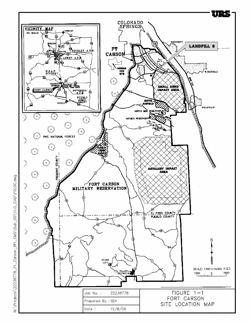
The proposed real estate transaction is to lease 18.1518 acres of Fort Carson property for the construction and operation of a 2 Megawatt (2 MW) solar photovoltaic (PV) plant. The legal description of the location is included in Appendix A. The 2 MW Solar Project will be located inside a fenced-in site at the southwest corner of Titus and Brown atop and adjacent to Landfill 9. The location of inactive Landfill 9 is shown on the Fort Carson area map (Figure 1-1). Inactive Landfill 9 is located southeast of the intersection of Titus Boulevard and Brown Road in the south 1/2 of the southwest 1/4 of the southeast 1/4 of Section 21 and in the north 1/2 of the northwest 1/4 of the northeast 1/4 of Section 28, both in Township 15 South, Range 66 West (Figure 2-1).
The project will consist of approximately 30,770 First Solar FS-65 65 watt photovoltaic modules, four 500 kVA inverters and two 1 MVA 480V-12.42 kVA step up transformers.
The scope of work to be performed includes: system engineering; site preparation; foundation construction; construction of the security fence; mounting system construction; module placement; trenchwork for conduit; pouring concrete pads for inverters and transformers; ; installation of the inverters and transformers; wiring and grounding of the array; physical interconnection to the Fort Carson grid at the Titus Substation; installation of the monitoring system; and system performance testing and commissioning (email communication, Kevin Christy).
2.0 SCOPE OF EBS
In general, an EBS is a study of the environmental conditions of Army controlled properties and proposed acquisitions, focusing on hazardous substances or other regulated hazards. The EBS determines if hazardous substances were stored, released into the environment or structures, or disposed of on the property selected for transfer or lease. The Army uses the EBS to determine whether or not use of the property poses a hazard to human health or the environment. The EBS will also include information regarding polychlorinated biphenyls (PCBs), petroleum products and their derivatives, asbestos, radon, lead-based paint, and unexploded ordnance (UXO).
1

3.0 HISTORICAL CHRONOLOGY
Following implementation of the Part B Permit in 1995 (CDPHE 1995), fieldwork activities were performed at inactive Landfill 9 between 1996 and 2005 to satisfy Part B Permit requirements to locate landfill boundaries and investigate environmental media in the vicinity for the presence of organic chemicals and metals in groundwater, surface water, and soil (Earth Tech, Inc., 2006). The remaining area was previously disturbed due to the activities in the area when the landfill was created.
4.0 DESCRIPTION OF PAST AND CURRENT ACTIVITIES ON THE PROPERTIES AND ADJACENT PROPERTIES
4.1 Background
Fort Carson is located in the east-central portion of Colorado at the foot of the Rocky Mountain Front Range. The Installation is approximately 8 miles south of downtown Colorado Springs and 75 miles south of Denver, and occupies 137,404 acres in El Paso, Fremont, and Pueblo Counties. Fort Carson borders Colorado Springs on the north, State Highway 115 on the west, private land on the south, and Interstate 25 on the east. Land use adjacent to the Installation includes municipal, residential, agricultural, industrial, and other privately held interests. The Installation measures from 2 to 15 miles east to west and 24 miles along the north to south axis. The 5,752-acre Cantonment Area is located at the northern tip of Fort Carson.
4.2 Historical Land Use
Fort Carson was established in 1942 during World War II. The original portion of Fort Carson includes the Cantonment Area. The area containing the subject property was acquired in 1942 and previously used for farming and ranching. In 1965, approximately 78,700 acres were acquired, increasing the size of the Installation to the current 137,404 acres. Presently, the Installation is an active military training facility for both weapons qualification and field training. Principal industrial operations have been the repair and maintenance of vehicles and aircraft. Industrial operations primarily occur on the east side (referred to as the banana belt) and north end of the Cantonment Area and at Butts Army Airfield (BAAF). Weapons qualification and field training take place south of the Cantonment Area (downrange).
The RCRA Part B Permit was implemented at Fort Carson on October 29, 1995. The Part B Permit allows Fort Carson to store hazardous waste in containers and requires compliance with all conditions of the Permit and the Colorado Hazardous Waste Act, C.R.S. Section 25-15-101-327. The Part B Permit also describes corrective action activities and the identified SWMUs at Fort Carson. A site summary and waste summary listing known or suspected hazardous constituents of concern is presented for each of the 170 SWMUs currently listed in the Permit.
For SWMU 9, the RCRA Part B Permit lists groundwater, surface water, and soil as media of concern; identifies the known or suspected hazardous chemicals as volatile organic compounds (VOCs), semivolatile organic compounds (SVOCs), pesticides, herbicides, and metals; and directs Fort Carson to sample the environmental media in the vicinity to determine if any contamination is present or has been released from the SWMU.
2

RCRADate Process Step Comment 1973 Pre-RCRA The landfill was closed in accordance with regulation at the time. May 1994 RFA First step in the RCRA process (SAIC 1994). Resulted in designating
inactive Landfill 9 as a SWMU and recommended an RFI for the site. June 1994 Pre-RCRA Preliminary Assessment (ETA 1994). September 1995 RFI Part B permit issued (CDPHE 1995). September 1996 RFI Relative Risk Groundwater Study conducted (Rust 1997b). March 2004 RFI Historical research and site reconnaissance. August 2004 RFI Final RFI Work Plan (Earth Tech 2004b) was submitted to CDPHE. October–November 2004 RFI Performed field activities. December 2004 RFI Completed geophysical survey of landfill boundaries. January 2005 RFI Completed trenching to verify geophysical survey. February 2005 RFI Completed installation and monitoring of soil gas probes. March 2005 RFI Completed collection of final seep surface water sample. (Earth Tech, Inc., 2006)
The inactive Landfill 9 site is an open field located at the southeast corner of Titus Boulevard and Brown Road. No operations are currently performed at the site.
Previous disposal of construction debris at SWMU 9 raised concerns regarding potential impact to the environment. The nature of potential contamination in the media of concern at SWMU 9 (groundwater, surface water, or sediment) was determined through evaluation of the RFI data. No chemicals of potential concerns (COPCs) were identified at SWMU 9, and no concentrations of organic or inorganic chemicals were detected in the most recent groundwater samples collected during October 2001 (Earth Tech, Inc., 2006).
The Corrective Measure Study Landfill Cover Evaluation Report completed February 2007 for Landfill 9 suggested a 30 inch cover to accommodate terrain. This action was completed in April 2007. The Colorado Department of Public Health and Environment will review and approve this action.
4.3 Land Use
The proposed lease area contains Inactive Landfill 9, which is 6.44 acres of the area 18.1518 acres to be leased. The remaining land is considered previously disturbed due to the activities in the area when the landfill was created. Future land use of the facility will remain the same with the addition of the solar plant on top of the landfill and on property adjacent if the lease is approved. The closest residential community to the inactive Landfill 9 site is the Fort Carson Ute Hill Senior Officer Family Housing, which is located approximately 500 feet north of the site (Earth Tech, Inc., 2006).
4.4 Historical Activities
Archeological and historical studies have been conducted on Fort Carson for the past 60 years. A comprehensive review of the work is contained in the Integrated Cultural Resource Management Plan (ICRMP) (Gene Stout and Associates, 2002). Prehistoric and historic National Register eligible sites are known to occur throughout the Installation. The CantonmentArea, including the subject property, has been surveyed for cultural resources and is generally devoid of prehistoric materials and sites. Two National Register of Historic Places (NRHP)
3

Districts are located in the Cantonment Area, the Old Hospital Complex and the Waste Water Treatment Plant and Incinerator Complex. The Old Hospital Complex is located south of Prussman Boulevard, while the Waste Water Treatment Plant and Incinerator Complex are near Gate 20. There are no restrictions on adjacent land use due to the NHRP Districts (Memorandum of Agreement with the Colorado State Historic Preservation Office, 2002).
4.4.1 Is the property within a historic district? ___X__NO __ __YES
4.4.1.1 Are surveys required? __X__NO ____YES
4.4.2 Are there any buildings over 50 years old on the property? __X__NO _____YES
4.4.3 Is coordination with the State Historic Preservation Office Required?
__X___NO ____YES
5.0 DESCRIPTION OF HAZARDOUS SUBSTANCES AND PETROLEUM PRODUCTS MANAGEMENT PRACTICES
5.1 HAZARDOUS SUBSTANCES
Numerous hazardous/toxic materials are used on Fort Carson. These include: petroleum fuels, oils, lubricants, paints, industrial chemicals, pesticides, herbicides, radiological materials and military ammunition, explosives and dangerous articles.
The principal industrial operations at Fort Carson are the maintenance and repair of vehicles and aircraft. The Consolidated Maintenance Facility (Building 8000) and the FORSCOM Contract Maintenance Facility (Building 749) perform specialized repair of tactical vehicles, heavy construction, and engineering equipment. Lower level vehicle maintenance is performed at the Unit motor pools. Aircraft maintenance is performed at Butts Army Airfield.
5.1.1 Hazardous Materials Storage
Are there or have there been any hazardous materials stored at the site? __X__NO ____YES
5.1.2 Petroleum Releases
Have there been any spills or releases into the environment on the site? __X__NO ___YES
See discussion below regarding storage tanks and solid waste management units.
5.2 HAZARDOUS WASTE
4

Hazardous waste generated at Fort Carson is transported to the Hazardous Waste Storage Facility (HWSF), Building 9248, for processing by personnel under the Directorate of Environmental Compliance and Management (DECAM). Generally, hazardous wastes are placed in the 90-day storage area and shipped off-site for disposal, in accordance with Large Quantity Generator (LQG) requirements of the Resource Conservation and Recovery Act (RCRA). However, Fort Carson’s RCRA Part B Permit allows for wastes to be stored for longer than 90 days in the Treatment, Storage, and Disposal Facility (TSDF) located adjacent to the 90-day area. The permit, issued by the Colorado Department of Public Health and Environment (CDPHE) also requires the investigation and remediation (if necessary) of over 160 solid waste management units (SWMUs).
Currently, there are five Satellite Accumulation Points (SAP) on Fort Carson for the collection and temporary controlled on-site storage of hazardous waste. Hazardous waste from the SAPs and all other hazardous waste generated on the Installation is moved to the HWSF by personnel that have received general awareness training in accordance with the Resource Conservation and Recovery Act (RCRA) regulations. Wastes from SAPs must be turned in once 55 gallons has been generated and all other wastes require immediate turn-in to the HWSF, i.e., within 24 hours of generation.
5.2.1 Are there any SAPs on or adjacent to the sites? __X__NO ___YES
5.3 STORAGE TANKS
Above ground (AST) and underground (UST) storage tanks are located throughout the Cantonment Area, at Butts Army Airfield (BAAF) and certain downrange locations. Storage tanks are used to store fuels and used oil. Most ASTs have double-wall construction while a few have other provisions for secondary containment. A program is underway to remove USTs from the Installation.
5.3.1 AST/UST Sites: Are there or have there been any state-registered aboveground or underground storage tanks on or adjacent to the subject property? __X__NO ____YES
5.4 INSTALLATION RESTORATION PROGRAM (IRP)
The purpose of Fort Carson’s IRP is to investigate for the potential of, and/or remediate contamination in the environment that resulted from past Army actions. In 1995, Fort Carson applied for a RCRA Part B Permit for the storage of hazardous wastes. This effort was undertaken to address the ability for “long-term” storage times that otherwise would exceed the Large Quantity Generator (LQG) allowed for hazardous wastes. As part of the permit requirement, Fort Carson had to perform a RCRA Facility Assessment (RFA) to identify former and current solid waste management units (SWMU’s) to determine if any contamination was released that could pose a threat to human health and the environment.
5.4.1 IRP Sites Identified On The Property
Are there or have there been any SWMUs with any remedial activities on the properties? ___ __NO __X__YES
5

A portion of the subject property contains inactive Landfill 9 (SWMU 9). The contents of the main debris disposal area include soil and construction debris based on observation of exposed wood, metal, wire, and concrete rubble at various locations. Previous disposal of construction debris at SWMU 9 raised concerns regarding potential impact to the environment. The nature ofpotential contamination in the media of concern at SWMU 9 (groundwater, surface water, or sediment) was determined through evaluation of the RFI data. No COPCs were identified at SWMU 9, and no concentrations of organic or inorganic chemicals were detected in the most recent groundwater samples collected during October 2001(Earth Tech, Inc., 2006).
5.4.2 IRP Sites Identified Adjacent To The Properties
Are there or have there been any SWMUs with any remedial activities on adjacent sites? __X__NO ___YES
6.0 RESULTS OF RECORDS REVIEWS
6.1 ASBESTOS CONTAINING MATERIALS (ACM)
No structures on site. Debris in the inactive landfill should not be disturbed during construction or operation of the solar plant.
6.2 LEAD BASED PAINT (LBP)
No structures on site. Debris in the inactive landfill should not be disturbed during construction or operation of the solar plant.
6.3 POLYCHLORINATED BIPHENYLS (PCBS)
No structures on site. Debris in the inactive landfill should not be disturbed during construction or operation of the solar plant.
6.4 RADON
Radon is a hazardous gas, arising from the natural decay of uranium in almost all soils, which may be present inside buildings. The Cantonment Area is classified by the EPA as Zone I, an area of high radon potential. Currently, there are no structures on the subject property.
6.5 PESTICIDES AND HERBICIDES
DOD approved pesticides and herbicides have been applied at Fort Carson to control weeds, insects, and other pests. Pesticide use has been in accordance with manufacturer’s directions and the Fort Carson Integrated Pest Management Plan. Since 1994, one insecticide release and one suspected herbicide release have been documented at Fort Carson. On January 6, 1995, an air release of an insecticide (Diazinon) at Building 1510 (the former Post Exchange) was reported to the National Response Center. On May 24, 2000, release of an unknown herbicide near the 2100 Area Barracks was suspected, but never confirmed. Both of these sites are located over a mile north of the subject property.
6

6.6 AIR PERMITS
Since September 1998 Fort Carson has operated under a Clean Air Act Title V Operating Permit (Permit # 95OPEP110) from the Air Pollution Control Division of the Colorado Department of Public Health and Environment (CDPHE). Fort Carson is a major source for carbon monoxide (CO), particulate matter (PM), nitrogen oxides (NOx), and volatile organic compound (VOC) emissions.
Any removal, replacement, or addition of any of the above listed or new air emission sources should be reported to the DECAM Air Program prior to being implemented to avoid potential compliance issues.
The licensee should be aware that the 1990 Amendments to the federal Clean Air Act prohibit the venting or release of Freon, or CFC and hydrochlorofluorocarbon (HCFC) refrigerant gases, from discarded appliances when they are disposed or recycled. CFCs and HCFCs must be removed from each appliance before they are disposed or delivered for recycling. The act provides for a $25,000 fine for each occurrence of intentional venting of CFCs. The final person in the chain must have a certificate showing the CFCs were recovered by a certified technicianusing a certified recovery machine.
6.7 RADIOACTIVE MATERIALS
There are no radioactive materials routinely stored or used on the subject property or within 0.5 miles of the subject property.
6.8 UNEXPLODED ORDNANCE (UXO)
The Army defines UXO as any explosive ordnance which has been primed, fused, armed, or otherwise prepared for action and which has been fired, dropped, launched, projected, or placedin such a manner as to constitute a hazard to friendly operations, installations, personnel, or material and remains unexploded either through malfunction or design or for any other cause. This definition does not include small arms rounds.
Observation of a partially buried, inert 105-millimeter practice artillery shell (dummy round) at an unspecified location within the SWMU 9 area was documented in a Preliminary Assessment of Fort Carson (Engineering Technologies Associates, Inc. [ETA] 1994). Dummy rounds are used for training exercises, contain no explosives, and are usually concrete filled. The exact location of the dummy round within inactive Landfill 9 cannot be determined from the information provided in the Preliminary Assessment. Since 1994, no additional dummy rounds have been found at SWMU 9 nor have any live rounds containing explosives or discarded casings from other spent rounds ever been found at SWMU 9 (Earth Tech, Inc., 2006).
6.9 HYDROLOGY
Fort Carson lies within the Arkansas River basin and nearby Fountain Creek is the major surface drainage feature. Several creeks and ditches cross the Installation and connect either with Fountain Creek or the Arkansas River. A 100-year floodplain is associated with drainages in the Cantonment Area.
7

Groundwater at Fort Carson occurs in both alluvial and bedrock aquifers. The alluvial aquifers are capable of providing well yields from 10 to more than 100 gallons per minute.
The nearest potential surface water receptor of runoff from the lease area is the intermittent unnamed stream channel located directly adjacent to the southwest side of the lease area. The intermittent unnamed stream channel joins with other main branches of Central Unnamed Ditch drainage approximately 6,500 feet to the southeast of inactive Landfill 9.
Groundwater samples collected from the CUD 4 monitoring well approximately 1,800 feet southeast of the inactive Landfill 9 site were analyzed for organic or inorganic chemicals during October 2001 and no detected concentrations exceeded regulatory screening criteria.
6.9.1 Floodplain: Are any of the subject properties located within the 100 year floodplain?
__ __NO This property is not located within the 100 year floodplain and does not fall under the purview of Executive Order 11988.
__X__YES This property is located within the 100 year floodplain and does fall under the purview of Executive Order 11988.
The southern end of the lease property is located within a 100 year floodplain. Floodplain area shown on Figure 3.
6.9.2 Wetlands: Will the proponent’s activities on the property result in a discharge of wastewater to an accumulation, collection, or drainage system? __ X___NO __ __YES
Can the existing wastewater collection system and treatment systemaccommodate such discharge without adverse operational or environmental impacts? __ ___NO __X__YES
Does the property contain wetlands regulated under Section 404 of the Clean Water Act (CWA) or fall under the purview of Executive Order 11990? __X__NO _____YES
7.0 VISUAL INSPECTIONS
7.1 OTHER OBSERVATIONS
Unusual Odors None observed Stained Soils None observed Stressed Vegetation/Unusual Dead or BareSpots
None observed
Leachate Seeps None observed Land Features related to human activities Silt fencing from recent widening of
Brown Road
8

Unauthorized dumping of trash/disposal Containers that may contain hazardous Substances?
Nothing observed; landfill debris covered by soil
8.0 RECORDS SEARCH
A review of various federal and state environmental databases was conducted for the subject property and surrounding area in order to obtain information on current or potential environmental liabilities in the land surrounding the property for lease. In addition, Fort Carson reports and records were examined in order to verify findings from the database search and to include the most recent information available.
There were no reports for the subject properties or for the specified radius search distance in the following Federal databases:
Federal National Priority List (NPL) sites within 1.0 miles Federal RCRA Treatment, Storage and Disposal (TSD) facilities within 1.0 miles CERCLIS for CERCLA sites within 0.5 miles
9.0 PERSONNEL INTERVIEWED
Stephanie Carter, DECAM Environmental Restoration Coordinator Mary Rosenthal, DPW Real Property Karen Downs, DECAM RCRA Coordinator
10.0 REFERENCES
32 CFR Part 651, Environmental Analysis of Army Actions; Final Rule, 20 March 2002
American Society for Testing & Materials, Philadelphia, PA, Standard Practice for Conducting Environmental Baseline Surveys, ASTM D 6008-96.
Army Regulation 200-1, Environmental Protection and Enhancement, 21 February 1997.
Army Regulation 405-80, Management of Title and Granting Use of Real Property, 10 October 1997.
Department of the Army Pamphlet 200-1, Environmental Protection and Enhancement, 17 January 2002.
Earth Tech, Inc. 2006. Final RCRA Facility Investigation Report Landfill 9 (FTC-013/SWMU 9) Fort Carson, Colorado. May.
Fort Carson Installation Action Plan, Fort Carson, CO, July 2002.
DECAM. Integrated Natural Resources Management Plan. April 2003.
Gene Stout and Associates, Loveland, CO, Environmental Assessment (Programmatic) for Military Installation Land Use at 7th Infantry Division and Fort Carson, Fort Carson, CO, March 2001.
9


APPENDIX A
LEGAL DESCRIPTION
11


FIGURES
14


100 Year Floodplains
1:5,000 Figure 3