urban studies alterations in scale: patterns of urban ... method for identifying and measuring the...
TRANSCRIPT
Article
Urban Studies2014, Vol. 51(16) 3383–3400� Urban Studies Journal Limited 2014Reprints and permissions:sagepub.co.uk/journalsPermissions.navDOI: 10.1177/0042098013519833usj.sagepub.com
Alterations in scale: Patterns ofchange in main street networksacross time and space
Sergio PortaUniversity of Strathclyde, UK
Ombretta RomiceUniversity of Strathclyde, UK
J Alexander MaxwellUniversity of Strathclyde, UK
Peter RussellUniversity of Strathclyde, UK
Darren BairdUniversity of Strathclyde, UK
AbstractThis paper presents a morphological study of 100 main street networks from urban areas aroundthe world. An expansion in the scale of main street networks was revealed using a unique heuristicvisual method for identifying and measuring the lengths of main street segments from each of thestudy areas. Case studies were selected and grouped according to corresponding urban designparadigms, ranging from antiquity to present day. This research shows that the average lengths ofmain street segments from networks of historic (i.e. ancient, medieval, renaissance, baroque andindustrial) and informal case studies are much smaller relative to those from networks of morecontemporary case studies (i.e. Garden City, Radiant City and New Urbanism). This study providesempirical evidence in support of prior, observational claims suggesting a consistent pattern in thesmaller scale of main street networks from traditional urban areas, termed the ‘400-metre rule’.Additionally, it makes the case for further empirical research into similarly recursive spatial patternswithin other elements of urban form (i.e. plots, blocks, etc.) that, if discovered, could aid in futureurban design efforts to help provide the framework for more ‘human-scale’ urban environments.
Corresponding author:
J Alexander Maxwell, University of Strathclyde,
Architecture, 75 Montrose Street, Level 3, James Weir
Building, Glasgow G1 1XJ, UK.
Email: [email protected]
by guest on March 5, 2015usj.sagepub.comDownloaded from
Keywords400-metre rule, main street network, main streets, urban morphology, urban theory
Received February 2013; accepted December 2013
Introduction
Cities are defined by a collection of bothphysical (e.g. streets, buildings and parks)and non-physical elements (e.g. history, cul-ture and politics). Some of the physical fea-tures change slowly throughout time, whileothers are subject to more rapid transforma-tions. This dynamic between various rates ofchange is vitally important in understandinghow urban form is able to adapt to fluctuat-ing economic, environmental and social cir-cumstances throughout time (Caniggia andMaffei, 2001; Conzen, 1960; Moudon, 1989;Slater, 1990).
As one of the more permanent features ofurban form, main street networks are vitallyimportant. Main street networks, repre-sented as intersecting systems of main streetsthat form unique main street segments(edges) and points of intersection (nodes),have been shown to share similar propertiesto those of other spatially complex networkssuch as power grids, mobile phone networksand neural networks (Barthelemy, 2011).Main street networks are also known toexert significant influence on people andtheir ability to navigate space (Hillier, 1996;Porta et al., 2010). Main streets have beenfound to remain central in the spatial organi-sation of urban areas throughout time acrosssignificant social, economic and environmen-tal changes (Strano et al., 2012). Similarly,many (Anderson, 1986; Jacobs, 1961; Mehtaand Bosson, 2010; Moughtin, 2003) havestated that careful concern should be givento the design of urban main street networksas dynamic vessels for human movementthat are intimately linked throughout time toboth physical and intangible elements ofplaces.
According to Mehaffy et al. (2010), thepattern of intersecting main streets, prior tothe advent of the automobile and the appli-cation of modern urban design paradigms,has followed a recurrent and consistenttrend, termed the ‘400-metre rule’. Accordingto this rule, urban areas comprised of qui-eter, mostly residential uses, also termed‘sanctuary areas’ after Appleyard (1981), arebordered by main streets that intersect atintervals that seldom exceed 400 metres.Intersections occur at the junction of two ormore streets, though not necessarily in theform of a rectilinear grid pattern. Main streetnetworks connect local urban areas withtheir regional context and have constitutedthe commercial and service backbone of cit-ies for many centuries, allowing non-residential uses to take advantage of morecentral locations at the local and regionalscale. The scale of this spatial pattern, or400-metre rule, reflects the limitations ofpedestrian movements and the self-organising logic of social urban life prior tothe advent of the automobile, highways sys-tems and the application of professionalurban design paradigms in the early 20thcentury.
Based on preliminary observations,Mehaffy et al. (2010) argue that significantalterations to the scale of contemporarymain street networks, starting at the dawn ofthe 20th century, have been accompanied bya loss of a consistent spatial pattern and anexpansion in the lengths of main street seg-ments. These changes to urban form areinfluenced by several, interrelated factorsincluding an increase in post-World War IIhousing demand, the rise of the automobileindustry and federal highway systems (in the
3384 Urban Studies 51(16)
by guest on March 5, 2015usj.sagepub.comDownloaded from
USA), the growth of middle-class consumersand changes in market preferences, and sev-eral other social and political factors, includ-ing the application of professional urbandesign paradigms. These paradigms includeEbenezer Howard’s Garden City (Howard,1902), Clarence Perry’s Neighbourhood Unit(Perry, 1929), Le Corbusier’s Radiant City(Le Corbusier, 1933), and continue with con-temporary place-making and New Urbanism(Calthorpe, 2002; Congress for the NewUrbanism, 2013; Duany et al., 2009; Farr,2008).
In an effort to test the observationalclaims behind the 400-metre rule, this paperpresents the morphological analysis of 100diverse main street networks from differenthistoric, geographical, social and economicsystems using a unique heuristic visualmethod. The data gathered in this studyoffers empirical evidence in support of the400-metre rule and makes the case for fur-ther empirical research into the structure ofurban form and patterns linked to mainstreet segments. This may reveal similaralterations in the urban fabric of cities corre-sponding to the physical application ofurban design paradigms and other socialfactors.
Methodology
Selection of case studies
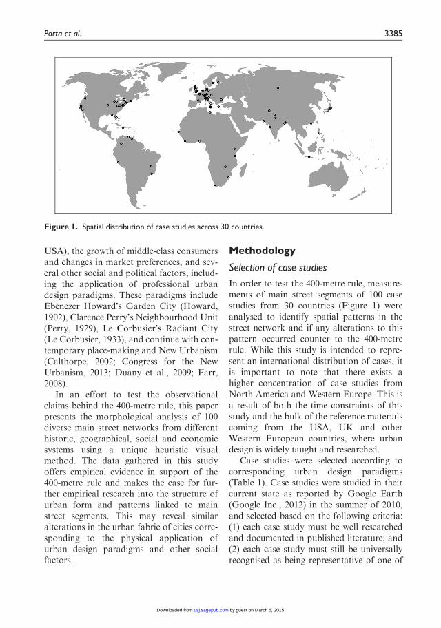
In order to test the 400-metre rule, measure-ments of main street segments of 100 casestudies from 30 countries (Figure 1) wereanalysed to identify spatial patterns in thestreet network and if any alterations to thispattern occurred counter to the 400-metrerule. While this study is intended to repre-sent an international distribution of cases, itis important to note that there exists ahigher concentration of case studies fromNorth America and Western Europe. This isa result of both the time constraints of thisstudy and the bulk of the reference materialscoming from the USA, UK and otherWestern European countries, where urbandesign is widely taught and researched.
Case studies were selected according tocorresponding urban design paradigms(Table 1). Case studies were studied in theircurrent state as reported by Google Earth(Google Inc., 2012) in the summer of 2010,and selected based on the following criteria:(1) each case study must be well researchedand documented in published literature; and(2) each case study must still be universallyrecognised as being representative of one of
Figure 1. Spatial distribution of case studies across 30 countries.
Porta et al. 3385
by guest on March 5, 2015usj.sagepub.comDownloaded from
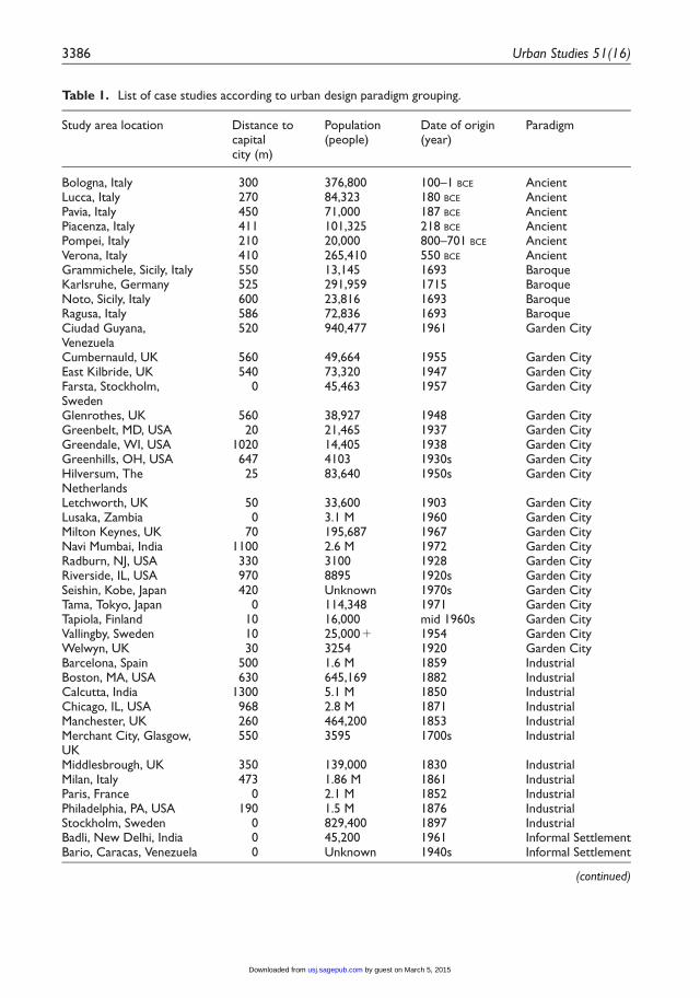
Table 1. List of case studies according to urban design paradigm grouping.
Study area location Distance tocapitalcity (m)
Population(people)
Date of origin(year)
Paradigm
Bologna, Italy 300 376,800 100–1 BCE AncientLucca, Italy 270 84,323 180 BCE AncientPavia, Italy 450 71,000 187 BCE AncientPiacenza, Italy 411 101,325 218 BCE AncientPompei, Italy 210 20,000 800–701 BCE AncientVerona, Italy 410 265,410 550 BCE AncientGrammichele, Sicily, Italy 550 13,145 1693 BaroqueKarlsruhe, Germany 525 291,959 1715 BaroqueNoto, Sicily, Italy 600 23,816 1693 BaroqueRagusa, Italy 586 72,836 1693 BaroqueCiudad Guyana,Venezuela
520 940,477 1961 Garden City
Cumbernauld, UK 560 49,664 1955 Garden CityEast Kilbride, UK 540 73,320 1947 Garden CityFarsta, Stockholm,Sweden
0 45,463 1957 Garden City
Glenrothes, UK 560 38,927 1948 Garden CityGreenbelt, MD, USA 20 21,465 1937 Garden CityGreendale, WI, USA 1020 14,405 1938 Garden CityGreenhills, OH, USA 647 4103 1930s Garden CityHilversum, TheNetherlands
25 83,640 1950s Garden City
Letchworth, UK 50 33,600 1903 Garden CityLusaka, Zambia 0 3.1 M 1960 Garden CityMilton Keynes, UK 70 195,687 1967 Garden CityNavi Mumbai, India 1100 2.6 M 1972 Garden CityRadburn, NJ, USA 330 3100 1928 Garden CityRiverside, IL, USA 970 8895 1920s Garden CitySeishin, Kobe, Japan 420 Unknown 1970s Garden CityTama, Tokyo, Japan 0 114,348 1971 Garden CityTapiola, Finland 10 16,000 mid 1960s Garden CityVallingby, Sweden 10 25,000+ 1954 Garden CityWelwyn, UK 30 3254 1920 Garden CityBarcelona, Spain 500 1.6 M 1859 IndustrialBoston, MA, USA 630 645,169 1882 IndustrialCalcutta, India 1300 5.1 M 1850 IndustrialChicago, IL, USA 968 2.8 M 1871 IndustrialManchester, UK 260 464,200 1853 IndustrialMerchant City, Glasgow,UK
550 3595 1700s Industrial
Middlesbrough, UK 350 139,000 1830 IndustrialMilan, Italy 473 1.86 M 1861 IndustrialParis, France 0 2.1 M 1852 IndustrialPhiladelphia, PA, USA 190 1.5 M 1876 IndustrialStockholm, Sweden 0 829,400 1897 IndustrialBadli, New Delhi, India 0 45,200 1961 Informal SettlementBario, Caracas, Venezuela 0 Unknown 1940s Informal Settlement
(continued)
3386 Urban Studies 51(16)
by guest on March 5, 2015usj.sagepub.comDownloaded from

Table 1. (Continued)
Study area location Distance tocapitalcity (m)
Population(people)
Date of origin(year)
Paradigm
Cemetery Squatters, Portau Prince, Haiti
0 100,000 1960 Informal Settlement
Dharavi, Mumbai, India 1140 1 M 1930 Informal SettlementHanna Nassif, Dar-es-Salaam, Tanzania
388 23,000 1960s Informal Settlement
Kakrail, Dhaka,Bangladesh
0 120,000 1980 Informal Settlement
Khayelitsha, Cape Town 1300 406,779 1957 Informal SettlementKibera, Nairobi, Kenya 0 1 M+ 1960s Informal SettlementKranidi, Greece 100 10,000 1970s Informal SettlementKricak, Yogyakarta,Indonesia
427 300,000 1950 Informal Settlement
Lagos, Lagos Island,Nigeria
530 209,000 1963 Informal Settlement
Las Colinas, Bogota,Columbia
0 10,000 1960 Informal Settlement
Lima, Hill Squatters, Peru 0 Unknown 1960s Informal SettlementMafalala, Maputo,Mozambique
0 22,000 pre 1975 Informal Settlement
Orangi Town, Karachi,Pakistan
1140 1.5 M 1965 Informal Settlement
Rocinha, Rio De Janeiro,Brazil
930 250,000 1970s Informal Settlement
Rufisque, Dakar, Senegal, 0 179,797 1987 Informal SettlementTondo, Manila, Philippines 0 630,000 900 Informal SettlementUrban Village, Shenzhen,China
1930 70,000 1980s Informal Settlement
West Point, Monrovia,Liberia
0 75,000 1980s Informal Settlement
Bremen, Germany 316 547,645 1032 MedievalLubeck, Germany 235 210,892 1143 MedievalNuremberg, Germany 380 503,600 1050 MedievalTripoli, Libya 0 1.06 M 1510 MedievalVerdun, France 220 19,624 1374 MedievalVienna, Austria 0 1.7 M 1440 MedievalBrentwood CA, USA 3700 4200 2005 New UrbanismCelebration FL, USA 1200 11,860 1990 New UrbanismCommunications Hill,Sacramento, CA, USA
3800 2800 units 2010 New Urbanism
Kentlands, Gaithersburg,MD, USA
30 2000 homes 1990 New Urbanism
Laguna West,Sacramento, CA, USA
3800 8414 1991 New Urbanism
Orenco Station, PortlandOR, USA
3700 .46,124 1997 New Urbanism
Poundbury, UK 186 6000 1993 New UrbanismRosemary Beach, FL, USA 1250 500 homes 1995 New Urbanism
(continued)
Porta et al. 3387
by guest on March 5, 2015usj.sagepub.comDownloaded from

the paradigms listed in Table 1 according toavailable literature. Historic cases (30) repre-sent main street networks that correspond toancient (6), medieval (6), renaissance (3),
baroque (4) and industrial (11) paradigms,while contemporary cases represent thoseselected from the Garden City (20), RadiantCity (20) and New Urbanism (10) models.
Table 1. (Continued)
Study area location Distance tocapitalcity (m)
Population(people)
Date of origin(year)
Paradigm
Seaside, FL, USA 1250 2000 1979 New UrbanismWindsor, Vero Beach, FL,USA
1286 350 homes 1989 New Urbanism
Akademgorodok,Novosibirsk, Russia
2800 65,000 1950s Radiant City
Barbican Estate, London,UK
0 4000 1969 Radiant City
Blue Area, Islamabad,Pakistan
0 530,000 1958 Radiant City
Brasilia, F.D. Brazil 0 2.6 M 1960 Radiant CityCabrini Green, Chicago,IL, USA
968 15,000 1942–2008 Radiant City
Chandigarh, India 230 900,000 1953 Radiant CityCo-op city, New York,NY, USA
330 55,000+ 1973 Radiant City
Cumbernauld, UK 560 49,664 1956 Radiant CityDrumul Taberei,Bucharest, Romania
0 63,000+ 1974 Radiant City
La Grande Borne, Grigny,France
22 26,790 1980s Radiant City
Le Mirail, Toulouse,France
580 27,500 1968 Radiant City
Marzahn, Berlin, Germany 0 102,398 1977 Radiant CityMilton Keynes, UK 70 195,687 1967 Radiant CityPendrecht, Rotterdam,The Netherlands
60 12,400 1953 Radiant City
Pruitt-Igoe, St. Louis, MO,USA
1146 2740 units 1954–1972 Radiant City
Regent Park, Toronto,ON, Canada
352 10,385 1940s Radiant City
Roehampton, London,UK
0 13,000+ 1950s Radiant City
Stuyvesant Town, NewYork City, NY USA
330 25,000+ 1947 Radiant City
The Grand Ensemble ofSarcelles, Paris, France
0 60,196 1960s Radiant City
Tsukuba Science City,Japan
50 207,000 1960s Radiant City
Freudenstadt, Germany 575 23,690 1599 RenaissanceNeuf Brisach, France 390 2219 1697 RenaissancePalmanova, Italy 450 5406 1593 Renaissance
3388 Urban Studies 51(16)
by guest on March 5, 2015usj.sagepub.comDownloaded from
Informal settlements were also examined asan exploding phenomenon that cannot bealigned with any of the paradigms of urbandesign mentioned above. Informal settle-ments are urban areas often characterised aspoor places lacking access to clean water,safe sanitation, secure land tenure or durablehousing. The form and development ofinformal settlements, like the historic cases,lack influence from contemporary, profes-sional urban design theories.
Mapping
Mapping of urban street networks was con-ducted using Google Earth web-based, ima-gery software (Google Inc., 2012), historicmaps as needed, and Adobe Creative Suite 5graphic design applications. Google Earthhas been recognised as a valuable urbandesign tool for spatial education (Patterson,
2007) and urban analysis (Clarke et al.,2010; Farman, 2010; Sheppard and Cizek,2009). For the purposes of this study,Google Earth was used to generate threemaps of varying scales:
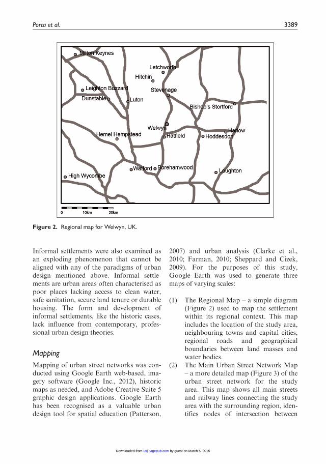
(1) The Regional Map – a simple diagram(Figure 2) used to map the settlementwithin its regional context. This mapincludes the location of the study area,neighbouring towns and capital cities,regional roads and geographicalboundaries between land masses andwater bodies.
(2) The Main Urban Street Network Map– a more detailed map (Figure 3) of theurban street network for the studyarea. This map shows all main streetsand railway lines connecting the studyarea with the surrounding region, iden-tifies nodes of intersection between
Figure 2. Regional map for Welwyn, UK.
Porta et al. 3389
by guest on March 5, 2015usj.sagepub.comDownloaded from
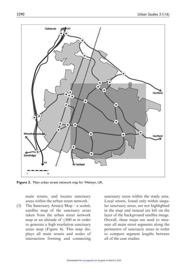
main streets, and locates sanctuaryareas within the urban street network.
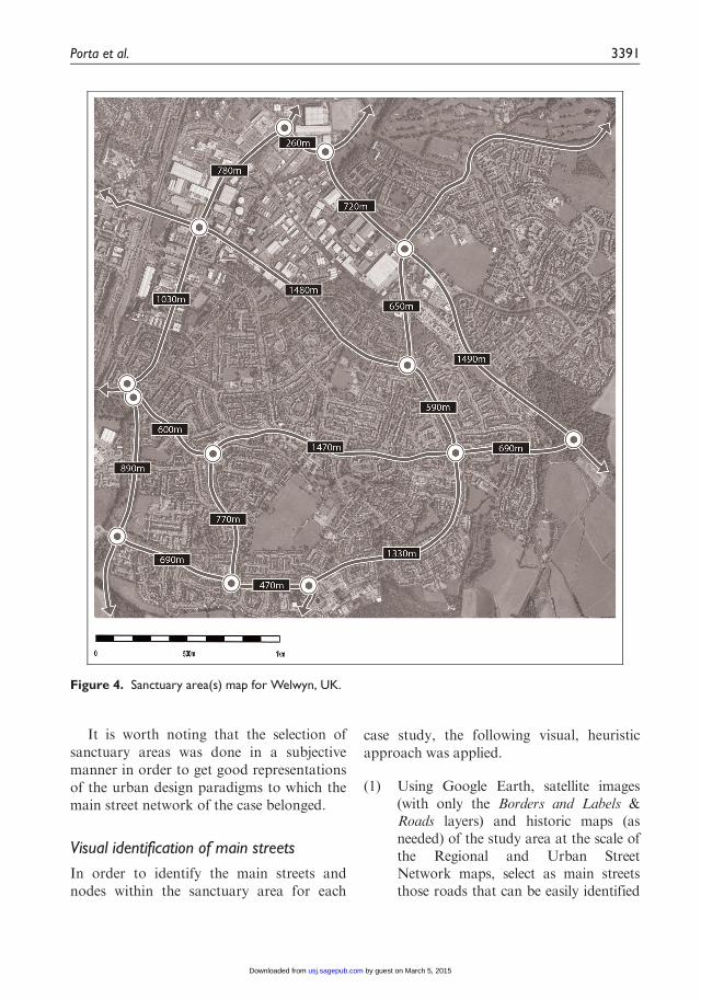
(3) The Sanctuary Area(s) Map – a scaled,satellite map of the sanctuary areastaken from the urban street networkmap at an altitude of �800 m in orderto generate a high resolution sanctuaryareas map (Figure 4). This map dis-plays all main streets and nodes ofintersection forming and connecting
sanctuary areas within the study area.Local streets, found only within singu-lar sanctuary areas, are not highlightedin the map and instead are left on thelayer of the background satellite image.Overall, these maps are used to mea-sure all main street segments along theperimeters of sanctuary areas in orderto compare segment lengths betweenall of the case studies.
Figure 3. Main urban street network map for Welwyn, UK.
3390 Urban Studies 51(16)
by guest on March 5, 2015usj.sagepub.comDownloaded from
It is worth noting that the selection ofsanctuary areas was done in a subjectivemanner in order to get good representationsof the urban design paradigms to which themain street network of the case belonged.
Visual identification of main streets
In order to identify the main streets andnodes within the sanctuary area for each
case study, the following visual, heuristicapproach was applied.
(1) Using Google Earth, satellite images(with only the Borders and Labels &Roads layers) and historic maps (asneeded) of the study area at the scale ofthe Regional and Urban StreetNetwork maps, select as main streetsthose roads that can be easily identified
Figure 4. Sanctuary area(s) map for Welwyn, UK.
Porta et al. 3391
by guest on March 5, 2015usj.sagepub.comDownloaded from
as connecting the study area to othertowns or cities. In Figures 2 and 3, themain streets are those roads that serveas the main connections between thetowns of Hertford, Hatfield, Sandridge,Oaklands and Wheathampstead.
(2) When a main street splits into two ormore directions, use visual clues suchas number of lanes, width of roads,and street names (e.g. High Street, M8,county road, etc.) to establish a hierar-chy of roads and determine the contin-uous path of the main street.
(3) Additionally, roads that traverse orserve as a connection across significantbarriers in the street network (i.e. rail-way lines, motorways, rivers, etc.) areselected as main streets.
(4) Nodes mark the intersection of two ormore main streets and serve as the end-points to the main street segments.Thus, main streets segments are definedas sections of main streets that origi-nate and end at nodes.
(5) In the case of squares and round-abouts, main streets can also be identi-fied as those streets that connect theendpoint nodes of other main streetsegments coming into the square orroundabout.
The heuristic approach is purely visual andbased on information that refers solely togeographical features and underlining con-siderations of connectivity of the street net-work. Other elements including traffic, landuse or demographics were not mapped ortaken into consideration during this study.
Method validation
The reliability of the visual identificationmethod was tested by conducting an exercisewith a group of fourth-year undergraduatearchitecture students. Students were selectedbased on their unfamiliarity with the
methods used in this study. During the exer-cise, each student was given a computer withGoogle Earth, a marker and a sanctuaryareas map from a set of ten study areas ran-domly selected to cover each of the urbandesign paradigm groupings. For example,referencing Table 2, five students were givenidentical maps of the Palmanova study area,while six students were given identical mapsof the Greendale study area and so forth.Given an hour, the students were theninstructed to follow the visual methoddescribed above to identify all main streetson the corresponding sanctuary areas mapusing a bold marker to mark all nodes andmain street segments. These results werethen compared with the main street seg-ments identified by the authors in order todetermine the number of similarly identifiedmain streets. These results are included inTable 2 below.
Overall, a total of 51 samples were col-lected from 25 students and 860 main streetsegments were identified. The percentage ofsimilarly identified main streets across all ofthe case studies used in this experiment was89%. When the samples included fewer mainstreets, the results from the student moreclosely matched those of the authors.
Statistical methods
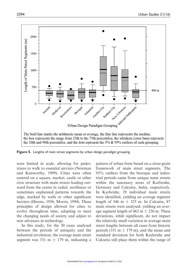
Descriptive statistics were calculated on themain street segment lengths for each of the100 case studies using SigmaPlot 10 (SystatSoftware Inc., 2006). These statistics werethen compiled to identify the means, stan-dard deviations, medians, minimum values,maximum values and outliers for eachperiod in the history of urban design andrepresented using a Tukey vertical box plot(Tukey, 1977) in order to make non-parametric comparisons in the resultsbetween each period in the history of urbandesign and determine the validity of the 400-metre rule (Figure 5).
3392 Urban Studies 51(16)
by guest on March 5, 2015usj.sagepub.comDownloaded from

Results
Both the mean and median can be used asmeasures of the central tendency of the sam-ple; however, while the mean values are pri-marily discussed below, it is important torepresent the median values, as the meanvalues can be affected by outliers as seen inthe Garden City, Radiant City and NewUrbanism cases. In these cases, the mediancan be used as a better measure of the mid-point of the sample. This graph (Figure 5)also shows the 400-metre mark to allow foreasier comparisons to be made in relation tothe 400-metre rule.
The average values for main streets fromancient, medieval, renaissance, baroque,industrial and informal settlement case stud-ies are 315 m 6 118 m, 299 m 6 146 m, 257m 6 127 m, 347 m 6 243 m, 343 m 6 185 mand 354 m 6 258 m, respectively. This sug-gests that most main streets from historicand informal settlement cases follow the400-metre rule. However, the mean valuesfor main streets from Garden City, RadiantCity and New Urbanism case studies varygreatly (1026 m 6 638 m, 843 m 6 714 mand 788 m 6 541 m, respectively) and arewell beyond the limit set by the 400-metrerule. This suggests that a change hasoccurred with the advent of professionalapproaches to modern and postmodernurban design, the spread of the automobileand other social forces mentioned above,causing the scale of urban street networks tobe altered.
Discussion
Historic cities
Since their inception, cities have been shapedby the environmental, economic and socialaims of communities (Hiorns, 1956; Morris,1994). Historic cities, formed in the absenceof automobiles, were designed according topractical principles with street networks thatT
ab
le2.
Res
ults
from
visu
alan
alys
isex
per
imen
t.
His
tori
cal
Gar
den
City
Rad
iant
City
New
Urb
anis
mIn
form
alSe
ttle
men
ts
Pal
man
ova
(A)
Lubec
k(B
)Le
tchw
ort
h(A
)G
reen
dal
e(B
)C
han
dig
arh
(A)
Dru
mul
Taber
el(B
)K
entlan
ds
(A)
Poundbury
(B)
Port
auPri
nce
(A)
Bogo
ta(B
)
Num
ber
ofsa
mple
s5
46
66
64
55
4N
um
ber
ofm
ain
stre
ets
per
sam
ple
628
27
19
814
23
917
22
Num
ber
ofm
ain
stre
ets
30
112
162
114
48
84
92
45
85
88
Perc
enta
geofsi
mila
rly
iden
tifie
dm
ain
stre
ets
100%
83%
87%
94%
100%
95%
83%
100%
86%
82%
Porta et al. 3393
by guest on March 5, 2015usj.sagepub.comDownloaded from
were limited in scale, allowing for pedes-trians to walk to essential services (Newmanand Kenworthy, 1999). Cities were oftencentred on a square, market, castle or othercivic structure with main streets leading out-ward from the centre in radial, rectilinear orsometimes unplanned patterns towards theedge, marked by walls or other significantbarriers (Hiorns, 1956; Morris, 1994). Theseprinciples of design allowed for cities toevolve throughout time, adapting to meetthe changing needs of society and adjust tonew advances in technology.
In this study, for the 30 cases analysedbetween the periods of antiquity and theindustrial revolution, the average main streetsegment was 331 m 6 179 m, indicating a
pattern of urban form based on a close-grainframework of main street segments. The95% outliers from the baroque and indus-trial periods came from unique main streetswithin the sanctuary areas of Karlsruhe,Germany and Calcutta, India, respectively.In Karlsruhe, 29 individual main streetswere identified, yielding an average segmentlength of 546 m 6 325 m. In Calcutta, 87main streets were analysed, yielding an aver-age segment length of 462 m 6 236 m. Thesedeviations, while significant, do not impactthe relatively small variation in average mainstreet lengths between all cases from historicperiods (331 m 6 179 m), and the mean andstandard deviation for both Karlsruhe andCalcutta still place them within the range of
Figure 5. Lengths of main street segments by urban design paradigm grouping.
3394 Urban Studies 51(16)
by guest on March 5, 2015usj.sagepub.comDownloaded from
the 400-metre rule. Overall, the evidencefrom these historic cases indicates a consis-tent pattern in the length of main street seg-ments that follows the 400-metre rule.
Responses to industrialisation
The industrialisation of cities built on aframework of close-grain street networksduring the late 18th and early 19th centuriesresulted in overcrowded, polluted and unsa-nitary living conditions (Hiorns, 1956;Morris, 1994). As a consequence, by the late19th and early 20th centuries, several newtheories of urban design were developed inan attempt to address these issues. Thisushered in a new era in the history of urbandesign focused on the generation of heal-thier urban environments based on severalimportant principles: improved efficiencythrough the use of modern transportationsystems and new building materials,separation of industry and other land usesto promote public health and the increasedinteraction of diverse demographicsthrough the better use of public open space.Ebenezer Howard’s Garden City (Howard,1902) and Le Corbusier’s Radiant City (LeCorbusier, 1933) were two of the most pro-minent of these new approaches to urbandesign based on the abovementioned theo-retical principles. It is also important tounderstand that they were realised asexpressions ‘sometimes, to be sure, almostunrecognisably distorted – of the ideas’(Hall, 2003).
Around the turn of the century, Howardproposed a relief to the urban conditions ofindustrial cities by envisioning cities thatwould provide access to country living. Inhis Garden City model, Howard designeddetailed diagrams of concentric garden citiesintended to fit on 600 acres of land andhouse 30,000 people, with an additional2000 living in the surrounding agrarian land.Boulevards, avenues and roads separated
residents from industry, which was placedon the edge of the cities, neighbouring farmsand forestlands. A series of greenbelts, masstransit systems and motorways were plannedto provide connection between neighbouringgarden cities and a central city of 50,000people. Theoretically, each Garden City wasdesigned to provide ample housing, jobs,manufacturing and access to open space(Howard, 1902).
While Howard’s Garden City modelserved as a logical alternative to the plightsof urban dwellers, it was never fully realisedin its original form. When the theoreticalprinciples of the Garden City model wereapplied, garden cities were sometimes trans-formed into diluted forms, conventionallyknown as garden suburbs, the kind analysedin the case studies from the Garden Citygrouping. Some of these cases includeCiudad Guyana, Venezuela, Greendale,USA and Letchworth, UK. These gardensuburbs, where activity is centred, industryis separated from residential areas and low-density residential development is clusteredtogether on the edges, while followingHoward’s principles, gave rise to the physi-cal manifestation now known as sprawl(Ward, 1992).
In the 30 cases studied from the GardenCity period, the average main street seg-ments measured 1026 m 6 638 m, more thandouble the 331 m 6 179 m of the 30 historiccase studies. This increase in segment lengthand the relatively high variability in theresults indicate an alteration in the scale ofthe urban street network counter to the 400-metre rule and the departure from tradi-tional spatial patterns.
Like Howard, Le Corbusier also soughtto improve public health, increase efficiencyand reconnect urban living with naturethrough his Radiant City model. LeCorbusier’s Radiant City was based on thetheoretical arrangement of high-density,residential skyscrapers connected through a
Porta et al. 3395
by guest on March 5, 2015usj.sagepub.comDownloaded from
series of aboveground highways on a recti-linear grid (Le Corbusier, 1933). In thismodel, traditional main streets became obso-lete, and were replaced with highways ele-vated above the ground. This left the groundplane to be given over to open space thatcould be used by pedestrians. Le Corbusierembraced the technological advances of theearly 20th century, principally the use of theprivate automobile as means of transporta-tion for the new masses of middle-classurbanities in the machine-age, while reject-ing appeals by others, including CamilloSitte (Sitte, 1889), to reinvestigate traditionalforms of urban design as a way to balancethe benefits of modern technology with theessential physical characteristics of historicurban forms (Le Corbusier, 1929).
Le Corbusier was able to fully realise oneRadiant City, Chandigarh, India. LikeHoward, his model was immensely influentialin informing, often literally and explicitly,innumerable others that have been con-structed according to similar principles.These are represented in the 20 cases selectedfrom the Radiant City grouping. These casesinclude Brasilia (Brazil), Regent Park,Toronto (Canada), and La Grande Borne,Grigny (France). While originally intended tobe arranged on a 400-metre framework, whenconstructed, Le Corbusier’s radiant citiesresulted in reformed grids of superblocks withmain street segments measuring up to 1065 m6 305 m as is the case in Chandigarh. Theaverage main street lengths for all of the casesfrom the Radiant City period measured 843m 6 714 m, more than double that of historicmain street segments. This again shows analteration in scale and loss of consistent pat-tern within the urban street network.
Overall, these two theories were based onprinciples that were designed to provideaccess to open space, set urban growthboundaries and deliver dense, transit-oriented communities. However, when fullyrealised, these theoretical approaches
contributed to unintended consequences thatinclude low-rise, residential sprawl, spatialand social segregation, decaying services andcommerce, declining public life and automo-bile dependence.
Response to the physical manifestations ofmodernist principles
Around the same time that Le Corbusierdeveloped his principles for the design of thecontemporary city, Clarence Perry suggesteda new way of organising and improvingupon the problems of industrial cities calledthe Neighbourhood Unit. NeighbourhoodUnits were focused on principles of walk-ability and were organised around signifi-cant, community structures, namely schoolsor churches, which would be accessible bypedestrians living no more than a 400-metreradius away from the centre (Perry, 1929).Main streets formed the perimeter of eachneighbourhood and were spaced in segmentsroughly 800 m apart, the same scale as thoseevident in the Garden City and Radiant Cityparadigms. Theoretically, this was meant toensure that a sense of community was devel-oped and that main streets were used toform the edges of neighbourhood sanctuaryareas (Ben-Joseph, 2005).
In response to the separation of land usesand sprawling designs resulting from theapplications of the modernist principles men-tioned above, New Urbanism was developedas a way to refocus urban design on creatingwalkable, mixed-use neighbourhoods built onthe principles of Perry’s Neighbourhood Unit(Congress for the New Urbanism, 2013).Started around the end of the 20th century,New Urbanism focuses on creating develop-ments based on a 400-metre radius whereessential services are located within a 400-metre walk of the neighbourhood centre.
In the 10 New Urbanism cases studied,the average length of main street segmentswas 788 m 6 541 m. Cases from this period
3396 Urban Studies 51(16)
by guest on March 5, 2015usj.sagepub.comDownloaded from
include the well-known developments ofSeaside, USA, Celebration, USA andOrenco Station, USA. These results reflectthe 800 m main street network that is a phys-ical manifestation of the 400-metre radius ofthe Perry’s Neighbourhood Unit. Like thecases from the Garden City and RadiantCity period, the New Urbanism cases alsorepresent a clear alteration in the scale of themain street pattern when compared withthose developed before the application ofprofessional theories in urban design.
Informal settlements
Interestingly, informal settlements representsimilar patterns to those of historic urbanstreet networks. The average main street seg-ment measured 354 m 6 258 m for the 20cases studied from this period, which is simi-lar to the 331 m 6 179 m average found in30 cases from historic cities. Cases from thisperiod included Badli, New Dehli (India),Kibera, Nairobi (Kenya) and Rocinha, RioDe Janeiro (Brazil). According to theseresults, in the absence of theoretical princi-ples of urban design, human settlementshave tended to organise themselves accord-ing to the 400-metre rule. This suggests thatinformal settlements can serve as contempo-rary examples of the self-organising logicthat was present in the patterns of historiccities.
Learning from the past: Towards urbansustainability
The scope of this paper is not to resort to thesimplistic notion that historic cities are spon-taneous and thus good, as opposed to con-temporary cities that are planned and thusbad. Instead, the focus of this study is tobring new evidence in support of the disci-plinary search for sustainable forms of urbandesign for the contemporary age. In mostcases, historic cities developed over time as a
result of both spontaneous and plannedefforts, similar to what can be observed incontemporary informal settlements, whichare often developed by non-institutional,sometimes illegal, local forms of authority.
With the increasing concerns over limitedeconomic and environmental resourcesgrowing more acute at the turn of the cen-tury, urban design practitioners havebecome increasingly interested in the diverse,close-grain street networks of historic citiesas a way to identify the essential characteris-tics of urban frameworks that providefor sustainability (Department of theEnvironment, Transport and the Regions(DETR) & Commission for Architectureand the Built Environment (CABE), 2000;Jones et al., 2007; Llewelyn Davies Yeang,2000; Tarbatt, 2012). Some of these charac-teristics include the ability of close-grainstreet networks to encourage alternativemodes of transportation, provide for well-connected, critical masses of customers tosupport local businesses, facilitate inclusionof diverse social groups in public places andcreate safe and attractive places for peopleto visit and live (Jones et al., 2007). Withinthe past several decades, New Urbanism andPlace Making have been developed as tworelated approaches based on these sameprinciples; however, this research shows thatwhen these principles become fully realisedinto physical urban forms, they share thesame alteration in the scale of main streetnetworks as other post-industrial, modernistdevelopments. This alteration in scale hasbecome a structural component of contem-porary urban landscapes with impacts to theway in which cities function. By identifyingconsistent patterns within the forms of moreresilient cities, practitioners will be betterequiped to make design decisions based onsound empirical evidence of what frame-works work throughout time and allow forprogressive adaptability as changing popula-tions continue to inhabit today’s cities.
Porta et al. 3397
by guest on March 5, 2015usj.sagepub.comDownloaded from

Conclusion
While this research is limited by the current
sample size, it does provide initial evidence
suggesting that main streets networks in his-
toric cities have predominantly followed the
400-metre rule. This research also suggests
that since the advent and application of pro-
fessional modern and postmodern urban
design theories at the dawn of the 20th cen-
tury, the distance between main streets in cit-
ies has roughly doubled. Therefore we assert
that an alteration in scale has occurred over
time in coincidence with the establishment of
modern and postmodern urban design para-
digms. However, the alteration in scale does
not appear in contemporary cities, which
have developed in the absence of more for-
mal planning and design (i.e. in informal
settlements).Explanations for the observations above
may vary, and the causal role of the historic
emergence of the automobile should be
taken into consideration as well as other sig-
nificant social and economic changes that
have occurred in step with the establishment
of urban design paradigms. However, all cit-
ies examined in this paper are contemporary
cities and therefore they all have cars. But,
only those built after the rise of the auto-
mobile and modern/postmodern urban
design paradigms had been planned for the
car by incorporating the neighbourhood unit
and other automobile-oriented designs.
Therefore, our conclusion is that the contri-
bution of urban design models to the unsus-
tainable, car-dominated city of today has
been, and continues to be, of crucial and
indeed generally underestimated importance.
This conclusion is further supported by the
final observation that contemporary cities,
when not formally planned, do not exhibit
signs of this alteration in scale.This important discovery requires further
research and has the potential to influence
the future efforts of urban designers as they
attempt to design today’s sustainable cities,
capable of reconciling the difference in time-
scales between the time required for urban
places to evolve and the time these places
are inhabited. The sudden increase in the
scale of the main street network could imply
a similar jump in the scale of other related
sub-structures of urban form (e.g. plots,
blocks, etc.). If this were the case, further
study of these urban elements could offer an
insight into different degrees of adaptability
between places and uses over time and
should prompt further research into more
time-sensitive design.The United Nation’s (UN) 2009 report on
global urbanisation prospects predicted thatthe global urban population will grow fromslightly over 50% of the total populationtoday to 70% by 2050, with developingregions contributing to the majority of thisgrowth (UN-Habitat, 2009). The magnitudeof this reality is such that the cost of reme-diating planning and design inadequacies willlikely be too great to bear from an economic,social and environmental point of view.Another UN report also suggests that themajority of urban growth is to take place insmaller settlements, of less than 500,000inhabitants, often lacking strong institutionalframeworks to enforce and implement devel-opment which is socially and environmen-tally sustainable (UN-Habitat, 2011). Farfrom advocating a no-planning approach,which would naively fail to address thenature of contemporary urban market, thispaper states that there is no better time thannow to identify and employ well-informeddesign principles to guide this development.This is rather a call for better urban designand planning, an evolved and more respon-sive discipline which would aim at the gener-ation of ‘a built-up area that keeps adaptingand transforming itself in unplanned neigh-bourhoods’ (Panerai et al., 2004: 159).
This paper serves as a call for furtherresearch into the essential logic and
3398 Urban Studies 51(16)
by guest on March 5, 2015usj.sagepub.comDownloaded from
principles of what generates a more adapta-ble, hence resilient, urban fabric. This essen-tial logic has to do with urban morphology:by better understanding the critical relation-ships between urban streets and plots, urbandesigners can begin to repair and developmore adaptable urban tissues, capable ofadjusting to changing demographics, econo-mies and cultures over time.
Funding
This research received no specific grant from anyfunding agency in the public, commercial, or not-for-profit sectors.
References
Anderson S (ed.) (1986) On Streets. London:
MIT Press.Appleyard D (1981) Livable Streets. London:
University of California Press, Ltd.Barthelemy M (2011) Spatial networks. Physics
Reports 499(1): 1–101.Ben-Joseph E (2005) The Code of The City: Stan-
dards and The Hidden Language of Place Mak-
ing. London: MIT Press.Calthorpe P (2002) The Urban Network: A New
Framework for Growth. Available at: http://
www.calthorpe.com/publications/urban-network-new-framework-growth, p. 6.
Caniggia G and Maffei GL (2001) Architectural
Composition and Building Typology: Interpret-
ing Basic Building (Fraser SJ, trans.). Florence:
Alinea Editrice.Clarke P, Ailshire J, Melendez R, et al. (2010)
Using Google Earth to conduct a neighbor-
hood audit: Reliability of a virtual auditinstrument. Health & Place 16(6): 1224–1229.
Congress for the New Urbanism (2013) Charter
of the New Urbanism (Talen E, ed.). London:McGraw Hill Education, LLC.
Conzen MRG (1960) Alnwick, Northumberland:
A study in town-plan analysis. Transactions
and Papers (Institute of British Geographers)
27: 122. Available at: http://www.jstor.org/stable/621094.
Department of the Environment, Transport andthe Regions (DETR) & Commission for
Architecture and the Built Environment
(CABE) (2000) By Design/Urban Design in the
Planning System: Towards Better Practice.
London: DETR and CABE.Duany A, Speck J and Lydon M (2009) The
Smart Growth Manual. London: McGraw-Hill
Professional.Farman J (2010) Mapping the digital empire: Goo-
gle Earth and the process of postmodern carto-
graphy. New Media & Society 12(6): 869–888.Farr D (2008) Sustainable Urbanism: Urban
Design With Nature. Hoboken, NJ: John
Wiley & Sons, Inc.Google Inc. (2012) Google Earth, ver. 7.0. Avail-
able at: http://www.google.com/earth/.Hall P (2003) Cities of imagination. In: Hall P
(ed.) Cities of Tomorrow: An Intellectual His-
tory of Urban Planning and Design in the
Twentieth Century. Third Edition. Oxford:
Blackwell Publishing, pp. 6–7.Hillier B (1996) Cities as movement economies.
Urban Design International 1: 41–60.Hiorns FR (1956) Town-Building in History: An
Outline Review of Conditions, Influences, Ideas,
and Methods Affecting ‘Planned’ Towns Through
Five Thousand Years. London: G.G. Harrap &
Company Limited.Howard E (1902) Garden Cities of To-Morrow.
London: S. Sonnenschein & Co., Ltd.Jacobs J (1961). The Death and Life of Great
American Cities. New York: Random House.
Jones P, Roberts M and Morris L (2007). Redis-
covering Mixed-use Streets: The Contribution
of Local High Streets to Sustainable Commu-
nities. Bristol: Policy Press in association with
the Joseph Rowntree Foundation.Le Corbusier (1929) The City of To-morrow and
Its Planning (translated by Frederick Etchells
from Urbanisme: 8th edition). London: John
Rodher.Le Corbusier (1933) La Ville Radieuse (The Radiant
City) (1967 Reprint edition). London: Faber.Llewelyn Davies Yeang (2000) Urban Design
Compendium. London: English Partnerships.Mehaffy M, Porta S, Rofe Y, et al. (2010). Urban
nuclei and the geometry of streets: The ‘emer-
gent neighborhoods’ model. Urban Design
International 15(1): 22–46.Mehta V and Bosson JK (2010) Third places and
the social life of streets. Environment and Beha-
vior 42(6): 779–805.
Porta et al. 3399
by guest on March 5, 2015usj.sagepub.comDownloaded from
Morris AEJ (1994)History of Urban Form: Before
the Industrial Revolutions. Essex: Pearson Edu-cation Limited.
Moudon AV (1989) Built for Change: Neighbor-
hood Architecture in San Francisco. London:MIT Press.
Moughtin C (2003) Urban Design: Street and
Square. Oxford: Architectural Press.Newman P and Kenworthy J (1999). Sustainabil-
ity and Cities: Overcoming Automobile Depen-
dence. Washington, DC: Island Press.Panerai P, Castex J, Depaule JC, et al. (2004)
Urban Forms: The Death and Life of The
Urban Block. Oxford: Architectural Press.Patterson TC (2007) Google Earth as a (not just)
geography education tool. Journal of Geogra-phy 106(4): 145–152.
Perry C (1929) The Neighborhood Unit: Ascheme of arrangement for the family life com-munity. In: Regional Plan of New York and Its
Environs, Volume VII. New York: Arno Press,p. 119.
Porta S, Latora V and Strano E (2010) Networksin urban design. Six years of research in multi-ple centrality assessment. In: Estrada E, FoxM and Higham DJ, et al. (eds) Network Sci-
ence. London: Springer, pp. 107–129.Sheppard SRJ and Cizek P (2009) The ethics of
Google Earth: Crossing thresholds from spa-tial data to landscape visualisation. Journal ofEnvironmental Management 90(6): 2102–2117.
Sitte C (1889) Der Stadtebau nach seinen kunstle-
rischen Grundsatzen (City Planning According
to Artistic Principles). Transl. by George R
Collins and Christiane Crasemann Collins.
London: Phaidon Press.Slater TR (ed.) (1990) The Built Form of Western
Cities: Essays for M.R.G. Conzen on the Occa-
sion of his Eightieth Birthday. Leicester: Leice-
ster University Press.Strano E, Nicosia V, Latora V, et al. (2012) Ele-
mentary processes governing the evolution of
road networks. Scientific Reports 2(296): DOI:
10.1038/srep00296.Systat Software Inc. (2006) Sigma Plot, ver. 10.
Available at: http://www.sigmaplot.com/prod-
ucts/sigmaplot/sigmaplot-details.php.Tarbatt J (2012) The Plot | Designing Diversity in
the Built Environment: A Manual for Architects
and Urban Designers. London: RIBA
Publishing.Tukey JW (1977) Exploratory Data Analysis.
Reading, MA: Addison-Wesley.UN-Habitat (2009) Global Report on Human Set-
tlements 2009: Planning Sustainable Cities.
London: Earthscan Ltd.UN-Habitat (2011) Global Report on Human Set-
tlements 2011: Cities and Climate Change.
London: Earthscan Ltd.Ward SV (1992) The Garden City: Past, Present,
and Future. Oxford: Spon Press.
3400 Urban Studies 51(16)
by guest on March 5, 2015usj.sagepub.comDownloaded from