urban renewal plan 072403arvadaurbanrenewal.org/wp-content/uploads/2016/05/ralstonfields... ·...
TRANSCRIPT
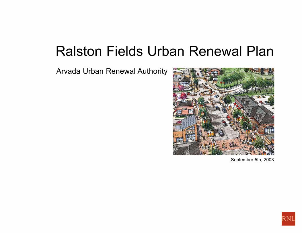
Arvada Urban Renewal Authority
Ralston Fields Urban Renewal Plan
September 5th, 2003
ACKNOWLEDGEMENTS
I
City of Arvada City CouncilKen Fellman, Mayor
Councilmember Don Allard, District 1
Councilmember Lorraine Anderson, District 3
Councilmember Aaron K. Azari, At-large
Councilmember Craig Smith, District 4
Councilmember Steve Urban, District 2,
Mayor Pro Tem
Councilmember Marc Williams, At-large
Arvada Urban Renewal AuthorityPhil Shell, Chairman
Mark Biere, Vice Chairman
Tim Geisler, Treasurer
John Boettiger
John Carpenter
David Kribs
Bud Smead, (Past Representative)
Steve Urban, City Council Representative
Timothy C. Steinhaus, Executive Director
Hazel Hartbarger, Deputy Director
Maureen Phair, Redevelopment Manager, Ralston Fields
Michael Polk, Legal Counsel
Pat Connelly, Executive Assistant
Cheryl Schauer, Administrative Specialist
Kelley Kraning, Intern
City of Arvada StaffMike Elms, Director of Community Development
Cheryl Drake-Holzhauer, Senior Planner
ConsultantsRNL DesignPatric Dawe, AIA, AICP, Project Manager
David Burczyk, Urban Designer
Trent Cito, Graphics
Cheryl Gouronc, Publication
Julie Roberts, Graphics
Jim Leggitt, AIA, Graphics
Felsburg Holt & UllevigDavid Hattan, PE
Holly Miller
BBC Research & ConsultingTom Pippin
Jim Carpenter
Martin/MartinWayne Harris, PE, PLS
Isaacson, Rosenbaum, Woods & Levy, P.C.Larry Kueter
Melinda Beck

Resolution No. _____________
A RESOLUTION APPROVING THE RALSTON FIELDS URBAN RENEWAL AND RELOCATION PLAN, AND MAKING CERTAIN FINDINGS OF
FACT.
FINDINGS OF FACT AND RESOLUTION:
The City Council of the City of Arvada, State of Colorado, having conducted a public hearing on the Arvada Urban Renewal and Relocation Plan,
which public hearing was duly published as required by 1973 C.R.S. 31-25-107 (3) (1977 Repl. Vol.),
FINDS AS FOLLOWS:
1. That a feasible method exists for the relocation of individuals and families who will be displaced by the Urban Renewal project in decent, safe
and sanitary dwelling accommodations within their means and without undue hardship to such individuals and families.
2. That the Urban Renewal Plan conforms to the Arvada Comprehensive Plan.
3. That the Urban Renewal Plan will afford maximum opportunity, consistent with the sound needs of the municipality as a whole, for the
rehabilitation or redevelopment of the urban renewal area by private enterprise.
NOW THEREFORE, BE IT RESOLVED BY THE CITY COUNCIL OF THE CITY OF ARVADA, COLORADO:
That the Ralston Fields Urban Renewal and Relocation Plan is hereby approved, and the Arvada Urban Renewal Authority is hereby authorized
to take any and all appropriate action as provided by said Plan.
PASSED, ADOPTED AND APPROVED, THIS _____ day of _________, 2003.
________________________
Mayor
ATTEST:
________________________
City Clerk
II
TABLE OF CONTENTS
III
Introduction.......................................................................................................
Goals & Purposes.........................................................................................
Urban Renewal Boundaries..............................................................................
Existing Conditions...........................................................................................
Development Plan.............................................................................................
Land Uses.........................................................................................................
Public Improvements........................................................................................
Streets & Roadways.........................................................................
Public Transportation...........................................................................
Water....................................................................................................
Sanitary Sewer.....................................................................................
Storm Sewer.........................................................................................
Recreation & Open Space................................................................
Building Requirements......................................................................................
Ridge Property Urban Renewal Plan................................................................
General Building Requirement..........................................................................
Prior Non-Conforming Uses.................................................................
Rehabilitation & Renovation.............................................................
Property Acquisition.............................................................................
Property Disposition.............................................................................
Redevelopment....................................................................................
Owner Participation..............................................................................
Demolition & Removal of Structures....................................................
Changes to & Variation from Plan....................................................
Timing & Phasing.............................................................................
Conformance with the Comprehensive Plan....................................................
Conformance with Zoning.................................................................................
Financing...........................................................................................................
Legal Description .............................................................................................
1
1
4
4
7
9
12
12
15
16
18
20
22
24
28
30
30
30
32
33
33
33
33
33
33
34
35
38
39
ILLUSTRATIONS
IV
List of Illustrations
Figure I Aerial Photo with Boundary.....................................................
Figure II Ralston Fields Context ..........................................................
Figure III Opportunities..........................................................................
Figure IV Urban Renewal Concept........................................................
Figure V Existing Land Use...................................................................
Figure VI Lands Use/Proposed..............................................................
Figure VII Street Improvements...............................................................
Figure VIII Water.......................................................................................
Figure IX Sanitary Sewer........................................................................
Figure X Storm Water...........................................................................
Figure XI Open Space............................................................................
Figure XII Triangle Urban Design Requirements....................................
Figure XIII Ridge Urban Design Requirements........................................
Figure XIV Existing Zoning.......................................................................
Figure XV Proposed Zoning....................................................................
Figure XVI Urban Renewal Map...............................................................
2
3
6
8
10
11
13
17
19
21
23
25
31
36
37
44
Ralston Fields Urban Renewal Plan 1
IntroductionThe Arvada Urban Renewal Authority initiated this Urban Renewal
Plan to provide an overall planning and implementation guide for
three adjacent areas in Arvada, collectively known as Ralston
Fields. The areas are the Ridge Property, the Lutz/Stenger Sports
Complex and the Triangle retail shopping district in the vicinity of
58th and Kipling in Arvada.
Meanwhile, the city intends that upgrades be made to the area
known as the Triangle, home to three retail centers and multi-
family housing. The Urban Renewal Area is close to Olde Town
Arvada and the retail shopping district on Wadsworth that has
developed as a result of the Arvada Urban Renewal Plan. The
proximity is so close as to create one functional center out of the
two separate areas, with shopping, recreation, housing
opportunities and public amenities within easy reach of sound
residential neighborhoods.
AURA previously commissioned a plan for the Ridge property,
which described a concept and implementation plan for that
property owned by the State Land Board. Since that plan's
completion, Melody Homes developed a single family residential
neighborhood on the ridge between the Ridge property and the
Lutz/Stenger Sports Complex.
Goals and Purposes of the Urban Renewal PlanThe Urban Renewal Plan is designed to provide a plan for the
following in the Urban Renewal Area:
· To create an Urban Center that meets DRCOG criteria as
described in the Metro Vision Update. It should do this through
higher densities and an employment base that meet DRCOG
criteria.
· Provide a mixed-use concept with mixed income and affordable
housing that supports the potential of a light rail station, as an
urban center and mixed-use area.
· Create a new image and identity for the area, including a new
name (Ralston Fields).
· Remove the blighting and economic obsolescence conditions
defined in the Existing Conditions Report.
· Revitalize and update the retail function in the triangle, while
keeping existing vitality, to strengthen Arvada's economic base
and facilitate the full economic development potential of the
Urban Renewal Area.
· Be self-sustaining financially, generating tax revenue that will
pay for needed improvements and programs.
· Create the focus for the community that people will want to
move close to and spend time in.
· Keep stability in the surrounding neighborhoods as they evolve,
providing service and attractions for the various types of user
groups in the neighborhoods.
· Upgrade the Stenger and Lutz athletic playfield complex and the
Recreation Center with needed amenities.
· Solve traffic, circulation and access problems, to facilitate the
benefits of the proposed Light Rail system station, and to
encourage pedestrian and bicycle modes.
· To implement the adopted Arvada Comprehensive Plan and the
Urban Renewal Plan and to assist in accomplishing the regional
growth for the Denver Metro Area by promoting the Arvada
Activity Center.
· To assure that development will be sensitive to, protect and
serve surrounding areas and prevent the spread of blight, and
that the relocation of existing residents and businesses will be
fair and equitable.
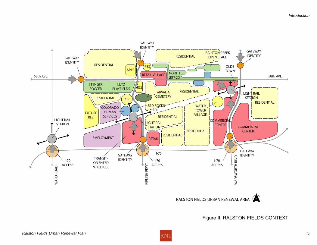
Arvada ContextRalston Fields at Kipling together with the Arvada Urban Renewal
Area at Wadsworth are the heart and urban center of Arvada. As
Figure II shows, these two areas are connected by 58th Avenue
and the proposed Gold Line; together they offer comprehensive
amenities for the surrounding neighborhoods. The attractions of
this area include playfields, shopping-power center, historic
downtown and urban village multi-family and single-family
neighborhoods, schools, and a planned future Light Rail system
with stops at Kipling and Wadsworth.
All this is connected along 58th Avenue, where City Hall and the
Post Office are located. Future features proposed for Ralston
Fields include new multi-family housing and village-scale retail
shopping, playfield improvements, and new power center
shopping. This is an urban center with potentials as a magnet for
new families and individuals seeking an urban neighborhood with
a small town lifestyle.
Introduction
Ralston Fields Urban Renewal Plan 2
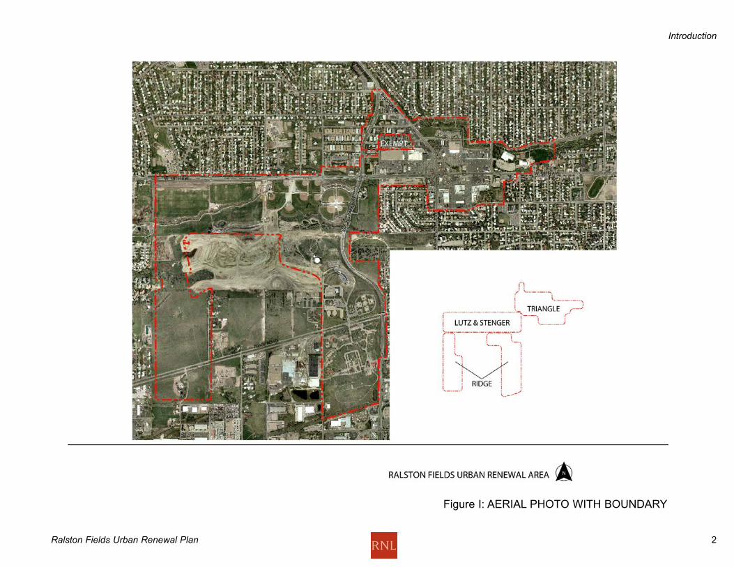
Figure I: AERIAL PHOTO WITH BOUNDARY
Introduction
Ralston Fields Urban Renewal Plan 3
Figure II: RALSTON FIELDS CONTEXT
Introduction
Ralston Fields Urban Renewal Plan 4
Urban Renewal BoundariesThe Ralston Fields Urban Renewal Area totals 543 acres including
streets and includes land in three connected areas of Arvada: the
Ridge Home property west of Kipling Parkway and south of Melody
Homes; the Stenger and Lutz playfields area, west of Kipling, south
of 58th and north of Melody Homes; and the Triangle, a largely retail
shopping area mixed with multi-family residential, north of 58th
between Kipling, Ralston Road, and Garrison Street. The map
(Figure I) illustrates the boundaries of the area.
Existing Conditions-The Case for RevitalizationExisting conditions in the Urban Renewal Area are documented in
the October 14, 2002 Arvada Triangle-Ridge Conditions Survey,
which has been adopted by the Arvada City Council. This report
constitutes the finding of blight for the Ralston Fields Urban
Renewal Area. This report is incorporated into this Urban Renewal
Plan by reference. Of the twelve statutory blight factors defined in
the Colorado Urban Renewal Law, this report states that ten of
these factors are present in the Urban Renewal Area, more than a
sufficient finding of blight. Specifically, conditions in each of the
three parts of the Urban Renewal Area are described as follows:
TriangleThe area is a group of three small shopping centers consisting of
aging retail stock that continues to serve the surrounding
community. Arvada Plaza was once the shopping destination for
much of Arvada. K-Mart, Safeway and King Soopers anchor the
group of centers, with smaller in-line and free-standing retail stores
and auto-oriented service establishments along 58th Street.
Remnants of the old Ralston Road that swung to the northwest from
58th still remain. Overall, the image of this area is faded and less
than desirable, and many of the stores have inadequate sightliness
from the street. Parking is adequate, but is awkward to navigate on
foot or by car. A substantial amount of retail space over a large
area of parking and streets lends to the lack of a positive image and
identity. Few street connections to the surrounding community
exist. The area is surrounded by neighborhoods with good housing
stock and an aging population, creating opportunities over the next
several years for younger families to locate here, near services and
activities that they need. The area needs to be made more
attractive to existing and new residents, and enlivened by the
addition of mixed uses, including residential development.
RidgeThe former human services center has discontinued at this site, and
much of the property has been sold. The Colorado Human Services
Division has bought back some of the property from the State Land
Board and is using the buildings to continue to provide services to
resident clients. Much of the land that has been sold has been
developed and is not included in the Urban Renewal Area, such as
the Skyline Estates, by Melody Homes on the ridge. Two parts of
the site remain and are subject to development. The western
portion, north and south of Ridge Road is vacant open area. The
eastern portion adjacent to Kipling Parkway is mostly vacant, but
some buildings remain from the Ridge era. These buildings and the
infrastructure and streets on the site are planned for removal to
create a cleared site for new development.
Topography sloping down to the south toward 50th Street limits the
development potentials of the site, although a light rail corridor is
planned with a station stop at Kipling and Ridge Road. Otherwise
the site is terraced into several potential development sub-areas
which lend themselves to commercial and mixed uses, some uses
related to the proposed light rail station.
The area is ready for development into commercial and mixed uses
that take advantage of the high level of access from I-70 and Kipling
Parkway.
PlayfieldsThe playfield complex offers multiple soccer, baseball and softball
fields, but has inadequate access and inefficient parking for larger
tournaments. It also lacks amenities for spectators, such as walking
paths to fields, sufficient bathrooms, food service areas and other
deficiencies such as a lack of shaded areas for waiting and resting
for spectators and players. The playfields should be more closely
related to the commercial and food services in the Triangle, but the
pedestrian connections are not adequate.
The Van Bibber flood control project will be located along the south
side of 58th Street, displacing three of the existing ballfields.
Previously, four new ballfields were built to replace the displaced
fields.
Existing Conditions
Ralston Fields Urban Renewal Plan 5
The four new ballfields at the Southwest corner of W. 58th and
Kipling were constructed to replace those three fields. The scope
of this project will require changes in the parking and internal
access patterns of the complex. Along with this, the Lutz soccer
fields could be laid out more efficiently, to create more playfield
opportunities and easier pedestrian access. Finally, new,
improved facilities such as new playfields, seating, amenities,
parking and access would help this area be more of a draw and
more useful for the Arvada and regional community, and more of
an economic engine for the stores and restaurants in the Triangle
area.
Existing Conditions
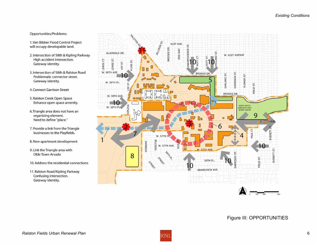
Ralston Fields Urban Renewal Plan 6
Figure III: OPPORTUNITIES
Existing Conditions
Ralston Fields Urban Renewal Plan 7
Development PlanThe Ralston Fields Urban Renewal Plan includes the Land Uses
(Figure V-VI), and the Public Improvements described in the text
and Figures VII - XI.
Principles of the Development PlanThe Urban Renewal Plan describes AURA's intention to create a
retail, residential and employment mixed use area as a center for
the established surrounding neighborhoods in Arvada. The
principles behind the Ralston Fields Urban Renewal Plan include
the following:
Create an attractive, pedestrian-oriented village center at the
Triangle. The vision for this area is a focal place for the surrounding
neighborhoods by offering retail shopping choices different than a
mall setting. A more compact, walkable retail district will be more of
a draw for the neighborhood. Conversion of some commercial land
to higher density residential is one way to create a more viable
setting for retail enterprise.
Use retail development in a walkable urban village on the Ridge
property to generate revenue for public improvements and other
assistance elsewhere in the Urban Renewal Area. Through tax
increment financing, early revenue-generating development can
fund later improvements. Later, development in the Triangle can
contribute to the revenue stream from the Urban Renewal Area.
Build on success of the Arvada Urban Renewal Area and Olde Town
Arvada. Complement the uses and market positions of URA and
Olde Town. Encourage retail uses and activities that complement
the Olde Town profile.
Create streetscape and activity connections between Olde Town
and Ralston Fields, including a streetscape program on 58th and a
transit linkage to Olde Town. The potential exists for joint
promotions and events that draw people to both areas at the same
time, benefitting both.
Establish entry gateways for identity of Ralston Fields-coordinate
with Olde Town. The streets that serve as entries into both these
should be positive visual experiences, and should communicate
something of the character of Arvada to approaching drivers.
Where possible, incorporate existing shops, stores and restaurants
into the retail pattern. Where it is necessary to introduce new
stores, shops and other enterprises, create attractive redevelopment
opportunities by working with the existing business and property
owners.
Connect the Village Center with the surrounding neighborhoods.
Walkways, street crossings and more pedestrian connections in the
Triangle will make it easier for neighborhood residents to walk and
bike to the Triangle, and easier to find their way once there. This
will enhance the business setting for the stores that locate there.
Mix housing and retail uses in Triangle area to activate the area.
Through conversion of some retail property to residential
development opportunities, the Triangle can be woven into the
neighborhood and additional market for the retail area can be
created. Mixed income and affordable housing will be part of the
development concept.
Make connections between the Lutz/Stenger Sports Complex and
the Triangle. Through development of the corner of 58th and
Kipling, a closer connection to the Sports Complex can be achieved,
bringing the benefit of the sports tournaments into the Triangle
because a direct visual connection is made. An opportunity for
affordable rental and ownership opportunities, including
improvements of existing multi-family housing are found in the
Urban Renewal Area.
Development Plan

Ralston Fields Urban Renewal Plan 8
Figure IV: URBAN RENEWAL CONCEPT
Development Plan
Ralston Fields Urban Renewal Plan 9
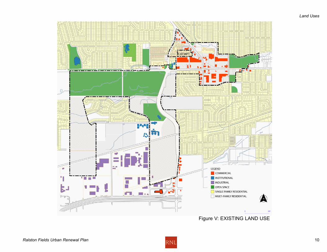
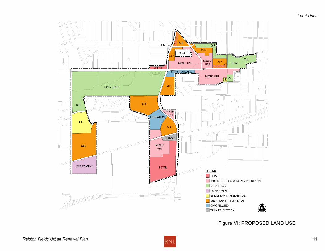
Land UsesExisting land uses are shown in Figure V and proposed land uses
are shown on Figure VI. The land use concept is to establish a
mixed use environment of retail, residential and employment that
offers flexibility to developers and the Urban Renewal Authority to
do both renovation and new development projects that reinforce
each other. The other land use objective is to accommodate
existing uses in place, and provide opportunities for new
development projects. Economic revitalization should be
successful as the area is developing, rather than having to wait
until all potential development is done before achieving results.
The plan leaves much of the existing retail development in place
while initiating new projects. Thus new projects can build on the
success of the existing in-place development.
Ridge Property: Retail use at the south end along Kipling accommodates larger
scale retail, while transitioning into mixed use accommodating
multi-family residential, office, showroom and other employment
development, such as flex office and transit use immediately
around the proposed Light Rail Station. North of Ridge Road,
multi-family housing of a town house density approximately 10-30
du/ac will relate to the Light Rail station, at such time as it is
developed.
On the west side of the Ridge property, employment uses may be
developed south of Ridge Road, while single-family and multi-
family residential can be developed north of Ridge Road. Single
family residential neighborhood development will relate in scale
and density to the existing single family residential development
on the ridge.
Playfields:This playfield park land use remains the same. Improvements
here are intended to create a more user-friendly parking and
access and amenities, and to increase the efficient use of the land
for recreation.
Triangle:The concept for this area is to create an urban village of
pedestrian-oriented and auto-oriented shopping mixed with multi-
family residential units. The Triangle will also provide an open
space linkage between the Lutz/Stenger Sports Complex and the
North Jeffco Garrison Street Sports Center and the Ralston Creek
open space corridor east of the Urban Renewal Area.
Retail use forms the core of the retail shopping area east of
Independence. Some retail uses bordering Garrison Street would
become higher density residential. The Meridian Retirement
Community anchors a multi-family district north of the grocery
stores. Mixed use residential and retail is proposed as a long-
term use on the north side of 58th east of Kipling. This mix of
uses would not be triggered until or unless the major retail uses
now there decide to relocate. The grocery store and K-Mart may
remain.
At the north end of the Triangle, the long-term future land use is
proposed as multi-family residential, building on the residential
already in this area. For the short term, the retail and restaurant
uses now in place may stay in place until they decide to relocate
or substantially renovate. Upon either of those triggers occurring,
the land use in this part of the Triangle would change to
residential, to support the commercial in the rest of the Triangle.
The multi-family residential uses in this area will remain.
The southeast corner of 58th and Kipling is shown as multi-family
residential for the entire parcel. As shown, the Van Bibber Creek
flood control project will occupy the south side of 58th Avenue as
a City-owned parcel in open space.
Land Uses
Ralston Fields Urban Renewal Plan 10
Figure V: EXISTING LAND USE
Land Uses
Ralston Fields Urban Renewal Plan 11
Figure VI: PROPOSED LAND USE
Land Uses
Ralston Fields Urban Renewal Plan 12
Public ImprovementsSome of the public improvements, streets and roads and
infrastructure, may be installed by the City of Arvada and some
may be installed by the developers of the properties in the URA.
All improvements shall be designed and installed to City of Arvada
standards and to all other applicable codes and ordinances to tie
into the existing systems.
Such improvements include but are not limited to sewer and water
facilities, streets, curbs and gutters, sidewalks, bikepaths, street
lights, telecommunication systems, parks, plazas and landscaped
areas and public transit facilities. These public improvements are
described and illustrated below, and described as to the
implementing body responsible for their design and installation.
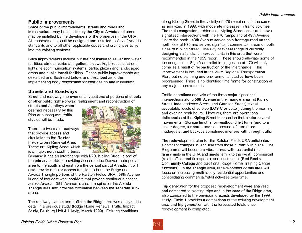
Streets and RoadwaysStreet and roadway improvements, vacations of portions of streets
or other public rights-of-way, realignment and reconstruction of
streets and /or alleys where
deemed necessary by this
Plan or subsequent traffic
studies will be made.
There are two main roadways
that provide access and
circulation to the Ralston
Fields Urban Renewal Area.
These are Kipling Street which
is a major, north-south arterial.
Because it has an interchange with I-70, Kipling Street is one of
the primary corridors providing access to the Denver metropolitan
area to the south and east from the central part of Arvada. It will
also provide a major access function to both the Ridge and
Arvada Triangle portions of the Ralston Fields URA. 58th Avenue
is one of two east-west corridors that provide continuous access
across Arvada. 58th Avenue is also the spine for the Arvada
Triangle area and provides circulation between the separate sub-
areas.
The roadway system and traffic in the Ridge area was analyzed in
detail in a previous study (Ridge Home Renewal Traffic Impact
Study, Felsburg Holt & Ullevig, March 1999). Existing conditions
along Kipling Street in the vicinity of I-70 remain much the same
as analyzed in 1999, with moderate increases in traffic volumes.
The main congestion problems on Kipling Street occur at the two
signalized intersections with the I-70 ramps and at 49th Avenue,
just to the north. 49th Avenue serves as a frontage road on the
north side of I-70 and serves significant commercial areas on both
sides of Kipling Street. The City of Wheat Ridge is currently
designing traffic island improvements in this area that were
recommended in the 1999 report. These should alleviate some of
the congestion. Significant relief in congestion at I-70 will only
come as a result of reconstruction of the interchange. This
improvement is included in the 2025 Regional Transportation
Plan, but no planning and environmental studies have been
programmed. There is no identified time frame for construction of
any major improvements.
Traffic operations analysis of the three major signalized
intersections along 58th Avenue in the Triangle area (at Kipling
Street, Independence Street, and Garrison Street) reveal
acceptable levels of service (LOS C or better) during the morning
and evening peak hours. However, there are operational
deficiencies at the Kipling Street intersection that hinder several
movements. Storage lengths for westbound left turns (and to a
lesser degree, for north- and southbound left turns) are
inadequate, and backups sometimes interfere with through traffic.
The redevelopment plan for the Ralston Fields URA anticipates
significant changes in land use from those currently in place. The
Ridge area will become a vibrant area with residential (multi-
family units in the URA and single family to the west), commercial
(retail, office, and flex space), and institutional (Red Rocks
Community College and traditional Ridge Home Training Center
functions). In the Triangle area, redevelopment of this area will
focus on increasing multi-family residential opportunities and
consolidating commercial/retail activities over time.
Trip generation for the proposed redevelopment were analyzed
and compared to existing trips and in the case of the Ridge area,
also compared to the previous forecasts developed by the 1999
study. Table 1 provides a comparison of the existing development
area and trip generation with the forecasted totals once
redevelopment is completed.
Public Improvements
Ralston Fields Urban Renewal Plan 13
Figure VII: STREET IMPROVEMENTS
Public Improvements

Ralston Fields Urban Renewal Plan 14
Public Improvements
Table 1 - Existing and Proposed Developed Areas and Trip
Generation
Location Area (s.f.) Daily Trips
Existing
Ridge 117,867 800
Triangle Tip 308,496 4,600
Triangle Core 715,592 30,600
Triangle Total 1,024,088 35,200
Proposed
Ridge 1,206,629 20,500
Ridge (99 Report 1,128,508 16,700
for similar area)
Triangle Tip 450,071 4,000
Triangle Core 971,525 24,600
Triangle Total 1,421,596 28,600
Table 1 shows that the Ridge area will experience significant
growth in the future, considering its currently underutilized status.
When comparing similar areas in the 1999 redevelopment
proposal, the amount of developed area will increase by
approximately seven percent while the amount of traffic is
expected to increase by approximately 22 percent (3,800 trips per
day). While the developed area in the Triangle is expected to
increase by approximately 400,000 square feet (almost 40
percent), the amount of daily traffic will decrease by 6,600 trips
(almost 19 percent). This reduction results from the conversion of
commercial land to multi-family residences. Residences generate
fewer daily and peak hour trips when compared to commercial
and retail uses. However, it is highly likely that background traffic
on both Kipling Street and 58th Avenue will continue to increase in
the future, at least at a nominal rate.
Based on the results of the trip comparison, the following
conclusions and roadway improvements should be considered in
the redevelopment planning for the Ralston Fields URA:
· 58th Avenue - Depending on the pace of redevelopment in the
Triangle area, only modest increases in traffic are foreseen.
The current street cross section east of Independence Street is
narrower than desired, and any replacement of adjacent
sidewalks should include widening of the street. West of
Independence Street, the street width is adequate with a nearly
continuous left-turn lane and westbound right-turn lane. As
there is redevelopment of the commercial area north of 58th
Avenue to residential, access points should be consolidated and
possibly a raised median could be constructed to break up the
wide expanse of asphalt. There are a number of right-in and/or
right-out only access points east of Independence Street on
both the north and south sides of the 58th Avenue.
Redevelopment plans should include consolidation of these
access points and consideration of right-turn auxiliary lanes at
major new intersections. Urban Renewal will be responsible for
installing the raised median and the City will be responsible for
the maintenance.
· Kipling Street - The basic four-lane sections on Kipling Street
north of 51st Avenue should be adequate for the forecasting
horizon. From 51st Avenue south, a number of improvements
were recommended in the 1999 Ridge Home study and all of
these are still applicable. The
City of Wheat Ridge is
currently designing the island
improvements along Kipling
Street north of I-70. Both the
Cities of Arvada and Wheat
Ridge should make
reconstruction of the I-70
interchange a priority for
regional roadway planning,
although improvements to I-70
are the responsibility of CDOT.
The Ridge redevelopment area will need full movement access
at both 50th Avenue (currently signalized) and 51st Place. A
new signal will be warranted at 51st Place.
· Access to properties from Kipling will be minimized to keep the
corridor flow steady without increasing delay time.
· The developer will be responsible for installing the signal at
51st., and for the North and South bound left turns. The City
will be responsible for maintenance of these items.

Ralston Fields Urban Renewal Plan 15
· 58th Avenue and Kipling Street - Although the number of
through lanes is adequate at this intersection, there should be
improvements to the auxiliary left turns to alleviate current
operational problems as well as anticipate whatever increases
in traffic there may be before redevelopment is complete. North
and southbound left turns at this intersection should also be
monitored in the future and appropriate left turn lanes
constructed if needed to accommodate volume or storage
requirements.
Public TransportationBusesThere are currently a total of five Regional Transportation District
(RTD) bus routes that serve the Ralston Fields URA. These
include three full-service routes that provide half-hour services
during the day. Routes #52 and #72 are east-west routes and
both run along 58th Avenue between Kipling Street and Olde
Town. Their schedules are coordinated so that there is a bus in
each direction every 15 minutes through the Triangle area. Route
#100 is a north-south route with hourly service through most of
the day and half-hour service during the morning and evening
peak hours. The route utilizes Ridge Road and Miller Street
through the Ridge area. Route 58x is an express route that
provides three buses in the morning and evening with direct
service along Kipling Street from the northwest to downtown
Denver. Route CC is a morning and evening peak hour service
between Coal Creek Canyon and the Olde Town Arvada Park-n-
Ride. There are four hourly buses in the morning peak period and
three in the evening. Through the Triangle area, CC buses follow
the route of the #72 buses (58th/Kipling/64th).
Shuttle service between Ralston Fields, City Hall, Post Office, Old
Town and Wadsworth and the neighborhoods in between could
have the effect of creating a unified draw in the area served by
these areas, and an element of unity between them.
Light RailThe Regional Transportation District is planning significant
changes to transit service in the Ralston Fields URA in the future.
RTD completed a Major Investment Study for the I-70 corridor in
2000 (I-70 Denver to Golden Major Investment Study, CH2MHill,
November 2000). The recommendation of the study (locally
preferred alternative or LPA) is the construction of a double-track
light rail transit (LRT) line from the Denver Union Terminal to Ward
Road. Through Arvada, the LRT would parallel the Burlington
Northern Santa Fe Railroad (BNSF) tracks that currently bisect
the Ridge area to provide service to the Coors brewery in Golden.
This alignment is commonly referred to as the Gold Line. Funding
and the timing of construction are dependent of the Fast Tracks
initiative that RTD will bring before the voters in the next several
years.
Transit service along the Gold Line will provide tremendous
opportunities for the Ralston Fields URA. Three stations are
planned in Arvada, and Ridge, near Kipling, would be the location
of the middle one. The current redevelopment plan (as well as
past plans) has been based on the accessibility opportunities that
this nearby station would provide. The pattern of development is
called Transit Oriented Development (TOD). The close proximity
of homes and businesses would mean that walking is a viable
option for many trips.
Construction of the Gold Line will also mean that RTD will add
local circulator services as well as reorient some of the local bus
service routes. The density of housing and commercial activity in
the Triangle area and the Ridge will enhance the opportunities for
transit service oriented to the Gold Line.
Public Improvements
Ralston Fields Urban Renewal Plan 16
No design decisions have yet been made on the location of the
light rail platform. Future determinations of passenger access will
be made, including passenger pick up and dropoff at the station.
The pedestrian crossing at Ridge Road at the station should
coincide with the intersection of Lee Street and Ridge Road.
InfrastructureThis project is under the jurisdiction of several districts and City of
Arvada, which are listed on the attached Table and as shown in
Figures IX, X, and XI. New infrastructure will be located in public
rights-of-way or dedicated tracts. These systems will be built on
to the existing infrastructure to the extent possible. Existing
services in areas to be renovated may need to be
removed/abandoned by the developer of the property to be
serviced.
WaterThe Urban Renewal Area is currently serviced by two (2) water
providers. The City of Arvada furnishes service to the north and
the Valley Water District serves the southern area. There is one
elevated water tower on the hill, which is owned and maintained
by the State of Colorado to serve the State buildings on the former
Ridge Home campus. The City of Arvada owns and maintains the
two on-ground water tanks. Water from these tanks will serves
the Arvada system or is pumped by the State into the elevated
tank.
In the Valley Water District the Developer will provide the Master
Planning and dedication of public right-of-way. The District will
then assemble all construction documents for the looped water
mains. The District will then solicit bids and manage the water
main construction. The Developer will be required to provide the
funds for the construction activity and inspection.
In the service area of the City of Arvada, the Developer will be
required to Master Plan his development and utilize looping to
provide adequate fire flows. The plans and specifications will be
prepared by the developer's engineer and then be reviewed and
approved by the City of Arvada. Construction activity will be
conducted by the Developer with periodic inspection and final
acceptance by the City.
In the Triangle Retail Shopping District some looped mains may
need to be abandoned and new loops designed. These lines may
be installed in the public right-of-way, or in utility easements
established by platting or separate document.
Public Improvements

Ralston Fields Urban Renewal Plan 17
Public Improvements
Figure VIII: WATER

Ralston Fields Urban Renewal Plan 18
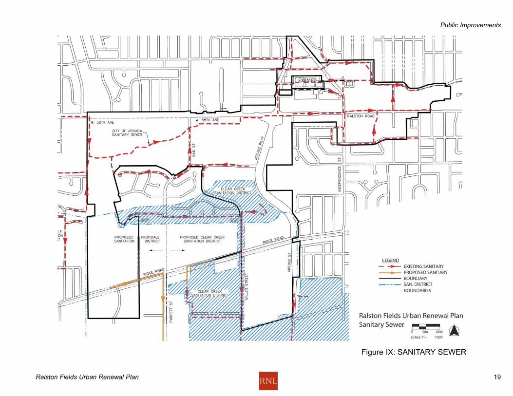
Sanitary SewerThe northern area of the site is served by the City of Arvada while
the southern portion will be served by the Fruitdale Sanitation
District and the Clear Creek Sanitation District. The Ridge
property will be served by the Clear Creek Sanitation District. The
western leg of the Urban Renewal Area could be served by either
District depending upon how the area north of Ridge Road
develops and what off-site mains are extended to the site.
Both Districts will design and prepare their own construction
documents for the sewer line extensions. Construction costs will
be paid for by the developer; however, the Districts will work with
the developer's contractors. Inspection and acceptance will be
conducted by each District. At the time of development, meetings
will need to be held with each District as their existing systems
have limited available capacities.
The City of Arvada has numerous trunk lines to serve this
development. As per the water main extensions the sanitary
sewer construction plans will be designed by the developer's
engineer and then reviewed and approved by the City of Arvada.
Inspection will be by the City; however, as-built plans must be
provided by the developer.
Public Improvements
Ralston Fields Urban Renewal Plan 19
Figure IX: SANITARY SEWER
Public Improvements

Ralston Fields Urban Renewal Plan 20
Storm SewerThe purpose of the storm sewer is to convey stormwater runoff
from developed areas to receiving channels or streams. All areas
are within the City limits of the City of Arvada and its jurisdiction.
All public storm sewers in public right-of-way will be designed by
the developer's engineer, reviewed and approved by the City of
Arvada and then constructed by the developer. The southern
portion of the site will also be reviewed by Urban Drainage as it is
included in the Columbine Basin Study.
A regional detention pond will be required at West 50th Avenue
and Kipling Street per the Columbine Basin Study. Developed
flows in this basin from each site will need to be detained on site
for the minor and major storm and water quality will need to be
addressed.
The proposed Regional Detention Pond near West 50th Avenue
currently has no outfall. The Columbine Basin Study indicates the
need for a drainage channel to be constructed. Currently the City
of Arvada and the City of Wheat Ridge are working toward this
goal.
The northern portion of the site drains into Van Bibber Creek and
then into Ralston Creek. A portion of Van Bibber Creek from Oak
Street to Ralston Creek is currently being upgraded. After
completion, the City will prepare a LOMR to remove the portion of
the Triangle west of Holland Street and some east of Holland from
the 100-year floodplain. Ralston Creek backup from Garrison
Street would still leave the area east of Holland subject to
flooding. Replacement of the bridge would remove the 100 year
flood plain for much of that area within the URA. No timetable
has been set for this redesign. Following this bridge
improvement, this area would then be suitable for redevelopment.
The retail area in the Triangle currently has no detention. The
City will work with the developer on maximizing detention
capabilities during renovation or redevelopment. Water quality
items must be addressed before discharging into the storm sewer
system.
Infrastructure Providers Relevant to Ralston Fields Urban
Renewal Plan
Clear Creek Valley Sanitation District
5420 Harlan Street
P.O. Box 156
Arvada, Colorado 80001
303.424.4194
Fruitdale Sanitation District
11460 West 44th Avenue
Wheat Ridge, Colorado 80033
303.424.5476
Valley Water District
12101 West 52nd Avenue
Wheat Ridge, Colorado 80033
303.424.9661
City of Arvada
Utility Administration
8101 Ralston Road
Arvada, Colorado 80002
720.898.7760
Public Improvements

Ralston Fields Urban Renewal Plan 21
FIgure X: STORM SEWER
Public Improvements

Ralston Fields Urban Renewal Plan 22
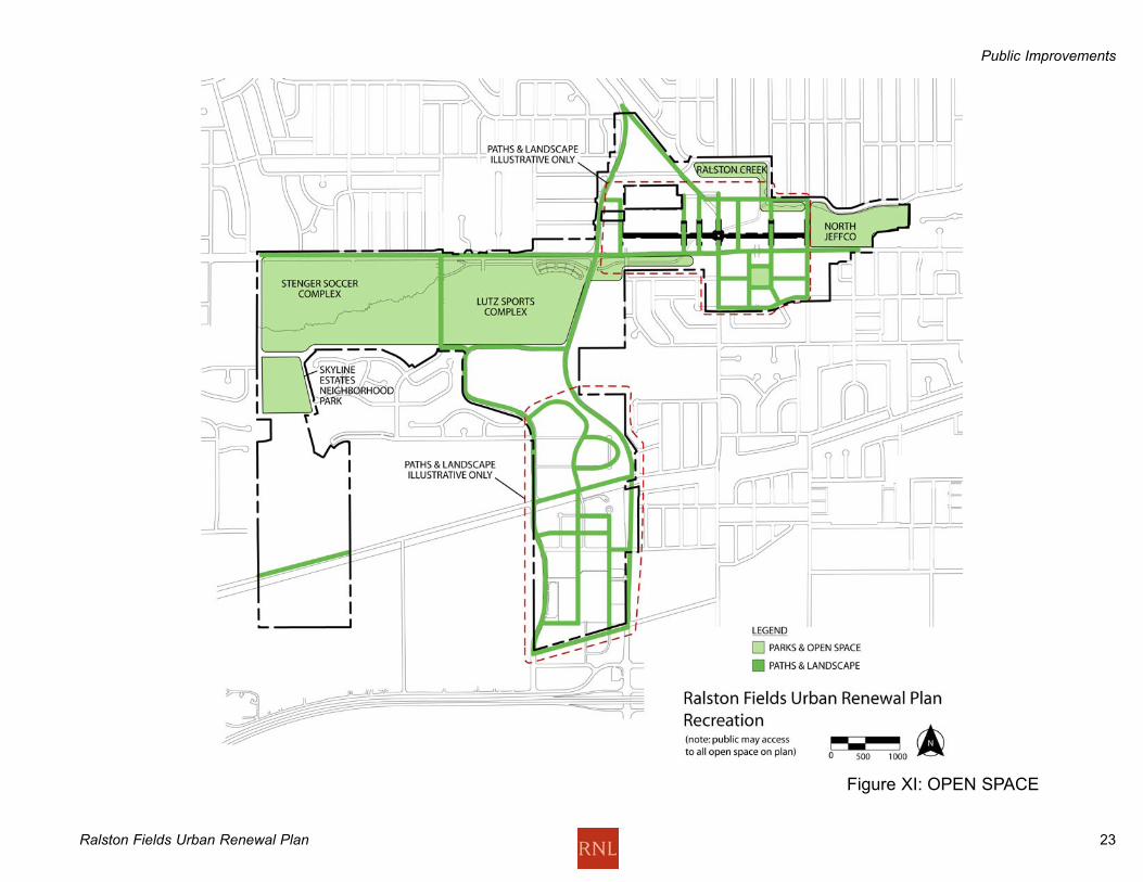
Recreation and Open Space The primary recreation facility in the Urban Renewal Area is made
up of the Lutz Sports Complex of ball fields and the Stenger Soccer
Complex, with several soccer fields, and the North Jeffeco Garrison
Street Sports Center. This complex is the focus of recreation
facilities in the immediate area, and it is a regional draw for sports
teams, who take part in tournaments drawing thousands of
participants.
The proposal for this complex is for parking and layout
improvements to the Stenger Soccer Complex, with the addition
and reorganization of parking and other amenities that will enhance
the performance of the sports complex.
Running through the Ralston Fields Urban Renewal Area is the Van
Bibber Creek, which is approved for a flood control project
involving channelizing the creek and creating landscaped side
slopes within a right-of-way along the creek, eventually running into
the Ralston Creek drainage east of the Urban Renewal Area
through an underground culvert. Along the path of this creek is the
Van Bibber Creek Primary Off-Street Trail in the City of Arvada
Parks, Trails and Open Space Plan. This trail, having regional
connections, will be maintained through the area to connect at
either end with the regional trail system. The North Jeffeco
Garrison street center and 58th Street will continue to be upgraded
and improved.
Two Community On-Street Trails, running north-south along Kipling
and west of Kipling, are incorporated into this plan. They both
connect to the Van Bibber Creek Trail.
Ridge Property: A grid of pedestrian-oriented streets and
pedestrian walkways, plazas, courtyards, landscaping and other
amenities is included in the plan for the Ridge Property, as shown
in Figure XIII. This street system is to be provided and improved
by the owner or developer of each property, subject to the
requirements of this plan.
The Triangle: A grid of pedestrian-oriented streets and pedestrian
walkways, plazas, courtyards, landscaping and other amenities is
included in the plan for the Triangle Property, as shown in Figure
XII. This street system is to be provided and improved by the
owner or developer of each property, subject to the requirements of
this plan.
Public Improvements
Ralston Fields Urban Renewal Plan 23
Figure XI: OPEN SPACE
Public Improvements
Ralston Fields Urban Renewal Plan 24
Building RequirementsGeneral RequirementsAny proposed development must conform generally with the
Comprehensive Plan and Land Development Code for the City of
Arvada and the Urban Renewal Plan for the Ralston Fields Urban
Renewal Area. The elements for a proposed development must
be arranged and designed to reflect the principles and objectives
of the development districts as described in the Comprehensive
Plan for the City of Arvada and the Arvada Land Development
Code, both of these as amended for consistency with the Urban
Renewal Plan.
AURA may, in conformance with the Urban Renewal Plan, impose
additional land use and design standards and controls and
architectural review requirements on any portion of the land
covered by this Plan, in addition to the building requirements
listed below.
In the event of inconsistencies between the Urban Renewal Plan
Building Requirements and the Land Development Code, the
Land Development Code standards shall prevail. Nothing in these
Building Requirements shall be construed as to conflict with or
nullify existing Building Codes and other regulations such as ADA,
related to the health, safety and welfare of the public.
Building Requirements are divided into the Triangle, Ridge and
Playfield areas, with requirements specific to each area.
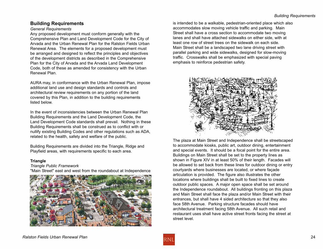
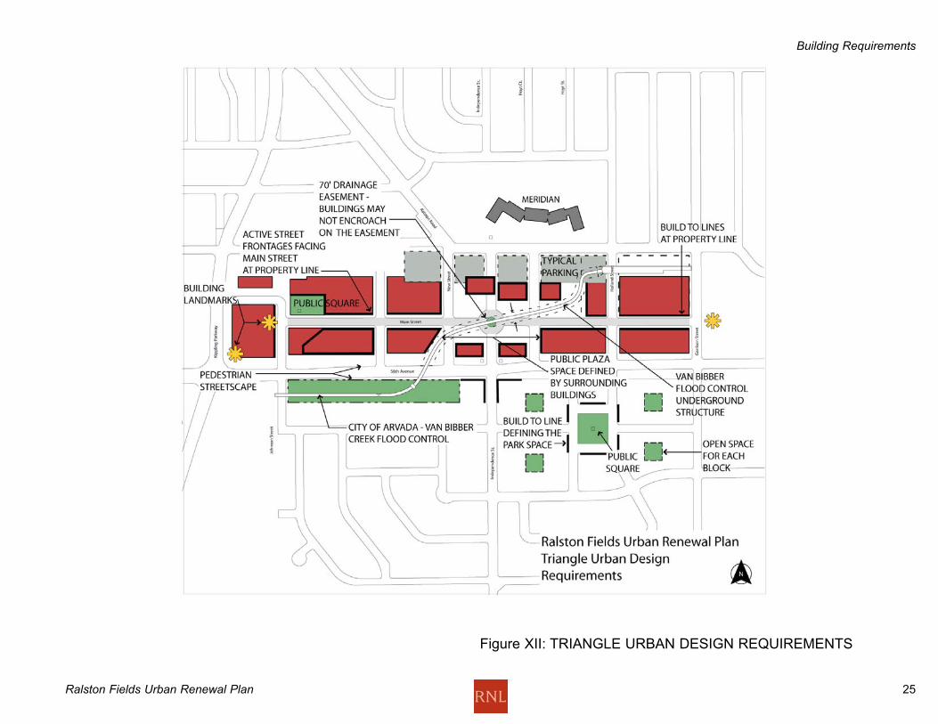
Triangle
Triangle Public Framework "Main Street" east and west from the roundabout at Independence
is intended to be a walkable, pedestrian-oriented place which also
accommodates slow moving vehicle traffic and parking. Main
Street shall have a cross section to accommodate two moving
lanes and shall have attached sidewalks on either side, with at
least one row of street trees on the sidewalk on each side.
Main Street shall be a landscaped two lane driving street with
parallel parking and wide sidewalks, designed for slow-moving
traffic. Crosswalks shall be emphasized with special paving
emphasis to reinforce pedestrian safety.
The plaza at Main Street and Independence shall be streetscaped
to accommodate kiosks, public art, outdoor dining, entertainment
and special events. It should be a focal point for the entire area.
Buildings on Main Street shall be set to the property lines as
shown in Figure XIV in at least 50% of their length. Facades will
be allowed to set back from these lines for outdoor dining or entry
courtyards where businesses are located, or where façade
articulation is provided. The figure also illustrates the other
locations where buildings shall be built to fixed lines to create
outdoor public spaces. A major open space shall be set around
the Independence roundabout. All buildings fronting on this plaza
and Main Street shall face the plaza and/or Main Street with their
entrances, but shall have 4 sided architecture so that they also
face 58th Avenue. Parking structure facades should have
architectural treatment facing 58th Avenue. All such retail and
restaurant uses shall have active street fronts facing the street at
street level.
Building Requirements
Ralston Fields Urban Renewal Plan 25
Figure XII: TRIANGLE URBAN DESIGN REQUIREMENTS
Building Requirements

Ralston Fields Urban Renewal Plan 26
Parking access shall be provided off Brooks Drive extended west, to
a series of parking areas behind the buildings. Parking access for
Main Street blocks shall be at the following places:
- North-South streets.
- The rear entrances of these blocks (i.e., off 58th at mid-blocks).
- No parking lots are allowed to front on Main Street.
Parking may be located in
these buildings, but not visible
from Main Street. Any parking
structures in the blocks along
Main Street shall be "wrapped"
with retail or office space, and
in the residential areas, the
wrap shall be residential units.
Sidewalks shall have a minimum clear width for walking of 10',
unobstructed by any permanent or temporary streetscape elements,
signs, displays or outdoor eating areas. Sidewalks may be used for
outdoor eating or retail sales, subject to approval by the City of
Arvada.
58th Avenue shall be streetscaped from Garrison to Kipling with
signage, lighting, landscaping, and clearly marked and accessible
entries into properties from 58th. The Van Bibber flood control
project will be landscaped on the south side of 58th.
Certain streets such as Holland and Garrison are to be extended
through the area to connect with neighborhoods on either side, both
for vehicles and pedestrians. Secondary streets shall have a
detached sidewalk on each side and shall meet all other applicable
design requirements adopted by the City for streets of a similar
classification.
Holland Street shall connect through from Brooks Drive to 56th
Place, south of the existing Arvada Plaza. A build-to street wall
shall be established around the neighborhood park at Holland
Street. Garrison Street shall be connected from 58th to 57th, with a
potential street connection from 57th straight west to the future
neighborhood park.
Triangle Land UsesRetail, restaurant and entertainment uses shall focus on the
immediate area of the plaza and be a compact, walkable area of 5-
8 minutes walking distance. It is not necessary or desirable for the
entire length of Main Street to be a commercial orientation. The
major focus of these uses should be the western two-thirds of Main
Street, especially the area of the plaza west to the end of Main
Street. The street east of here should be primarily residential in its
character with multi-family densities between 15 and 30 du/ac.
Safeway and King Soopers will be given an opportunity to remain in
their existing locations, but will be required to improve their stores to
create building frontages at the required build-to line. Main Street
runs in front of the existing buildings and the public open space
does not displace these buildings. These stores are also required
to attach active retail and food service uses or portions of their
stores accessible from the sidewalk to their facades to activate their
locations. The new Brooks Street as shown would not be built
unless Safeway re-configures its building or relocates. The precise
location of Brooks Street is to be determined.
K-Mart will be given an opportunity to remain or relocate elsewhere
in the Ralston Fields Urban Renewal Area and will be required to
improve their store. Main Street runs in front of the K-Mart building.
An active street frontage is required to reinforce the pedestrian
activity of Main Street. While existing stores are in place, Main
Street’s character will be as a low-speed driveway. Additional large
format retail stores are allowed in this area. If k-mart relocates, its
site should be converted to a public open space and retail space.
East and west of Independence, residential uses will prevail toward
the east and west ends of Main Street. These can be mixed uses
with retail or restaurant uses on the ground floors.
The Lutheran Church site, if redeveloped, shall have a
distinguishing architectural feature at the corner of 58th and Kipling.
It will face Main Street as well, and shall have a landmark feature
such as a tower or arch on axis with Main Street. The
Independence entrance to Main Street shall contain buildings that
are active on all four sides. There shall be a landscaped extension
of Independence extending north to the Meridian. It shall have
active storefront uses along this frontage.
Building Requirements
Ralston Fields Urban Renewal Plan 27
If a public building is developed in the future across Garrison Street,
it should emphasize the axis of Main Street by an architectural
feature, or location of its main entrance.
The block just east of the Lutheran Church shall have a setback
which allows views in from 58th to Main Street. The purpose of this
is to encourage the flow of pedestrians from the Lutz/Stenger
playfields to Main Street.
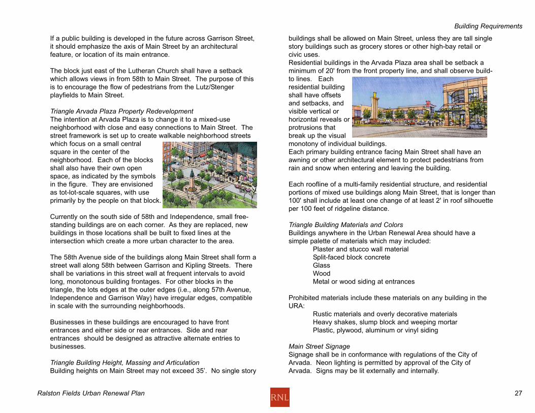
Triangle Arvada Plaza Property RedevelopmentThe intention at Arvada Plaza is to change it to a mixed-use
neighborhood with close and easy connections to Main Street. The
street framework is set up to create walkable neighborhood streets
which focus on a small central
square in the center of the
neighborhood. Each of the blocks
shall also have their own open
space, as indicated by the symbols
in the figure. They are envisioned
as tot-lot-scale squares, with use
primarily by the people on that block.
Currently on the south side of 58th and Independence, small free-
standing buildings are on each corner. As they are replaced, new
buildings in those locations shall be built to fixed lines at the
intersection which create a more urban character to the area.
The 58th Avenue side of the buildings along Main Street shall form a
street wall along 58th between Garrison and Kipling Streets. There
shall be variations in this street wall at frequent intervals to avoid
long, monotonous building frontages. For other blocks in the
triangle, the lots edges at the outer edges (i.e., along 57th Avenue,
Independence and Garrison Way) have irregular edges, compatible
in scale with the surrounding neighborhoods.
Businesses in these buildings are encouraged to have front
entrances and either side or rear entrances. Side and rear
entrances should be designed as attractive alternate entries to
businesses.
Triangle Building Height, Massing and ArticulationBuilding heights on Main Street may not exceed 35’. No single story
buildings shall be allowed on Main Street, unless they are tall single
story buildings such as grocery stores or other high-bay retail or
civic uses.
Residential buildings in the Arvada Plaza area shall be setback a
minimum of 20' from the front property line, and shall observe build-
to lines. Each
residential building
shall have offsets
and setbacks, and
visible vertical or
horizontal reveals or
protrusions that
break up the visual
monotony of individual buildings.
Each primary building entrance facing Main Street shall have an
awning or other architectural element to protect pedestrians from
rain and snow when entering and leaving the building.
Each roofline of a multi-family residential structure, and residential
portions of mixed use buildings along Main Street, that is longer than
100' shall include at least one change of at least 2' in roof silhouette
per 100 feet of ridgeline distance.
Triangle Building Materials and Colors Buildings anywhere in the Urban Renewal Area should have a
simple palette of materials which may included:
Plaster and stucco wall material
Split-faced block concrete
Glass
Wood
Metal or wood siding at entrances
Prohibited materials include these materials on any building in the
URA:
Rustic materials and overly decorative materials
Heavy shakes, slump block and weeping mortar
Plastic, plywood, aluminum or vinyl siding
Main Street SignageSignage shall be in conformance with regulations of the City of
Arvada. Neon lighting is permitted by approval of the City of
Arvada. Signs may be lit externally and internally.
Building Requirements
Ralston Fields Urban Renewal Plan 28
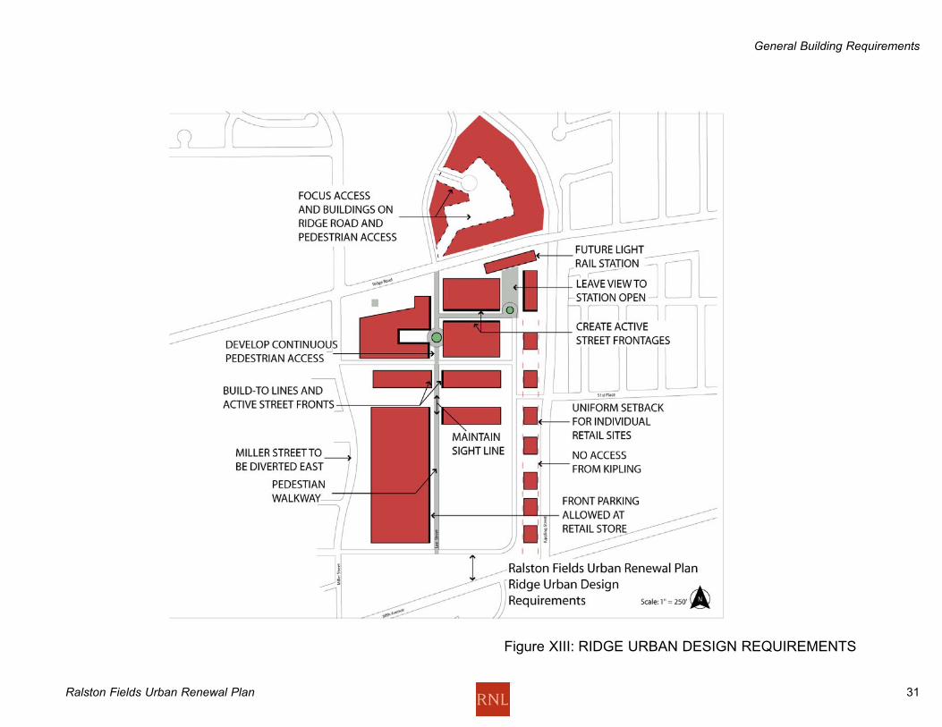
Ridge Property Urban Renewal PlanThe concept for the Ridge property between Kipling and Miller
Streets is a transit-oriented mixed use retail and residential area,
anchored by large footprint retail development. The Gold Line
light rail stop is expected to be located on the rail tracks along
Ridge Road between Kipling and Lee Streets in the future.
Therefore this area should orient itself to the future development
of the light rail station.
Ridge Public FrameworkThe framework of public streets shall form a north-south-east-west
grid facilitating pedestrian movement to the transit station, in order
to create a walkable, pedestrian-oriented place in the vicinity of
the station. The local streets shall accommodate slow moving
vehicle traffic and parking, balancing pedestrian and vehicular
access and convenience.
Two north-south rights of way shall connect the north and south
ends of the property, leading to the transit station and the crossing
of the rail tracks and Ridge Road:
A clear north-south visual corridor shall be established
along the commercial development
An internal street which
connects the freestanding
retail pads along Kipling,
and terminates at the
Light Rail station.
Crosswalks shall be emphasized
with special paving emphasis to reinforce pedestrian safety.
Buildings on the north-south walkway should be set to the
property lines as shown in Figure XIII for at least 50% of their
length if possible. The figure also illustrates the other locations
where buildings shall be built to fixed lines to create outdoor
public spaces. An open space shall be located at the Light Rail
station. All buildings fronting on this plaza and the adjacent
streets shall face the plaza and/or streets with their entrances. All
such retail and restaurant uses shall have active street fronts
facing the street at street level, when transit is in place.
Parking may be located in the buildings, but should not
predominate over pedestrian walkways. Any parking structures
near the transit station shall be at least partially "wrapped" with
retail or office space.
Secondary streets shall have a detached sidewalk on each side
and shall meet all other applicable design requirements adopted
by the City for streets of a similar classification.
If possible, Miller Street will be diverted to the east to allow for a
truck unloading area on the Coors Plant property. This alignment
will be determined between Coors and the developer of the Ridge
property.
Ridge Land UsesLarge box retail uses may be located at the south end of the
property only, attached to in-line smaller footprint retail buildings.
Parking for this group of retail stores may be in front of the
buildings.
Multi-Family Area North of Ridge Road The intention in this area is to establish a transit-oriented
residential neighborhood with close and easy connections to the
Light Rail Station. The street framework is set up to create
walkable neighborhood streets.
Building Requirements
Ralston Fields Urban Renewal Plan 29
Building Requirements
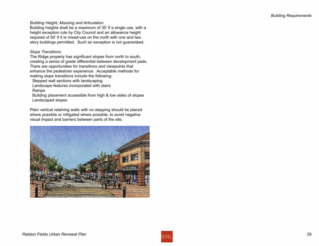
Building Height, Massing and ArticulationBuilding heights shall be a maximum of 35’ if a single use, with a
height exception rule by City Council and an allowance height
required of 50’ if it is mixed-use on the north with one and two
story buildings permitted. Such an exception is not guaranteed.
Slope TransitionsThe Ridge property has significant slopes from north to south,
creating a series of grade differential between development pads.
There are opportunities for transitions and viewpoints that
enhance the pedestrian experience. Acceptable methods for
making slope transitions include the following:
Stepped wall sections with landscaping
Landscape features incorporated with stairs
Ramps
Building placement accessible from high & low sides of slopes
Landscaped slopes
Plain vertical retaining walls with no stepping should be placed
where possible or mitigated where possible, to avoid negative
visual impact and barriers between parts of the site.
Ralston Fields Urban Renewal Plan 30
General Building Requirements Buildings anywhere in the Urban Renewal Area should have a
simple palette of materials including stone, brick or stucco.
Prohibited materials include these materials on any building in the
URA:
Rustic materials and overly decorative materials
Heavy shakes, slump block and weeping mortar
Plastic, plywood, aluminum or vinyl siding
Each roofline of a multi-family residential structure, and residential
portions of mixed use buildings that is longer than 100' shall
include articulation in the roofline.
Multiple tenant buildings should have a façade treatment and
articulation that depicts individual businesses, rather than one
long, uninterrupted building façade.
Automobile Parking StandardsAll development shall provide the minimum amounts of off-street
parking required by the Arvada Development Code.
Off-Street LoadingOff-street loading areas may not be located along the façade of
any primary structure facing a pedestrian walkway.
Screening and StorageMechanical equipment, ductwork, trash and storage areas shall
be shielded from view from any public right-of-way or adjacent
property by placement within buildings, or by enclosure within
opaque walls or fences not less than 5' in height, but in no case
lower than the items to be shielded. Wall and fence materials of
the enclosures shall complement the exterior building materials
and should have metal doors.
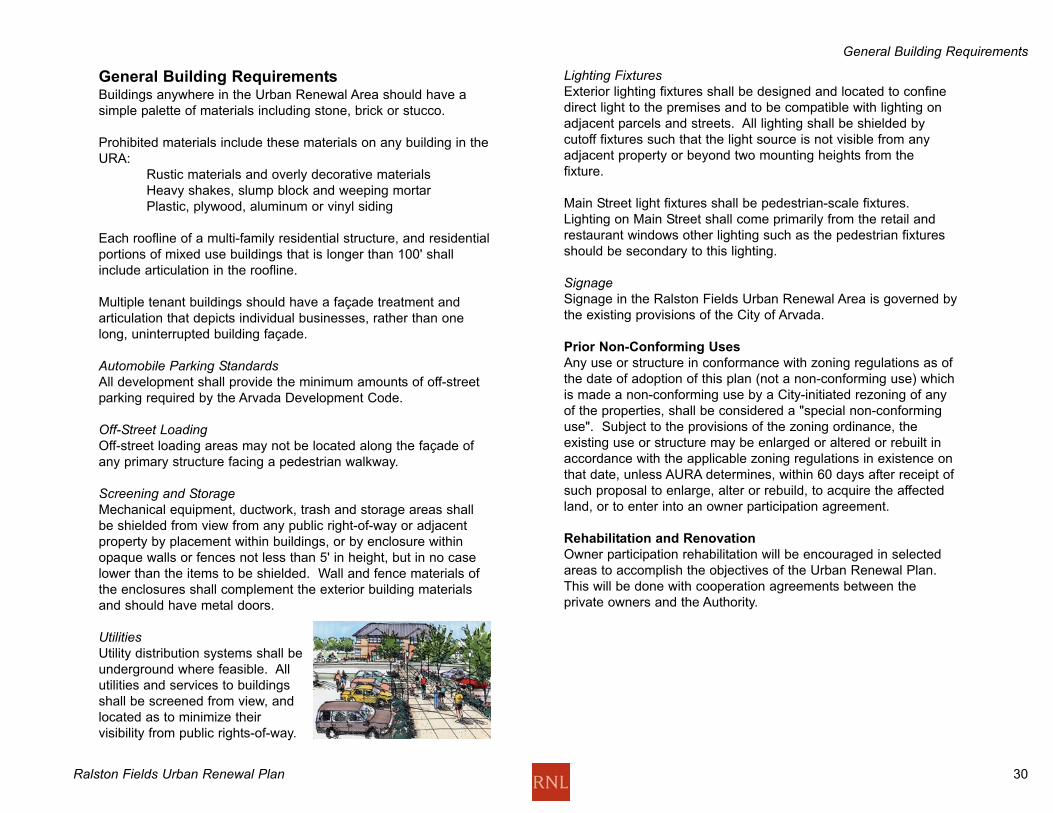
UtilitiesUtility distribution systems shall be
underground where feasible. All
utilities and services to buildings
shall be screened from view, and
located as to minimize their
visibility from public rights-of-way.
Lighting FixturesExterior lighting fixtures shall be designed and located to confine
direct light to the premises and to be compatible with lighting on
adjacent parcels and streets. All lighting shall be shielded by
cutoff fixtures such that the light source is not visible from any
adjacent property or beyond two mounting heights from the
fixture.
Main Street light fixtures shall be pedestrian-scale fixtures.
Lighting on Main Street shall come primarily from the retail and
restaurant windows other lighting such as the pedestrian fixtures
should be secondary to this lighting.
SignageSignage in the Ralston Fields Urban Renewal Area is governed by
the existing provisions of the City of Arvada.
Prior Non-Conforming Uses
Any use or structure in conformance with zoning regulations as of
the date of adoption of this plan (not a non-conforming use) which
is made a non-conforming use by a City-initiated rezoning of any
of the properties, shall be considered a "special non-conforming
use". Subject to the provisions of the zoning ordinance, the
existing use or structure may be enlarged or altered or rebuilt in
accordance with the applicable zoning regulations in existence on
that date, unless AURA determines, within 60 days after receipt of
such proposal to enlarge, alter or rebuild, to acquire the affected
land, or to enter into an owner participation agreement.
Rehabilitation and Renovation
Owner participation rehabilitation will be encouraged in selected
areas to accomplish the objectives of the Urban Renewal Plan.
This will be done with cooperation agreements between the
private owners and the Authority.
General Building Requirements
Ralston Fields Urban Renewal Plan 31
Figure XIII: RIDGE URBAN DESIGN REQUIREMENTS
General Building Requirements
Ralston Fields Urban Renewal Plan 32
Property Acquisition
General Building RequirementsAll property in the Urban Renewal Area except the City and
Recreation District is subject to purchase by the Authority.
However, it is the intent of the Authority not to purchase property
in the area described as the Triangle or Ridge areas except for 1)
rights-of-way which may be needed to implement the plan or 2)
selective property acquisition to enhance the Ralston Fields Urban
Renewal Plan. Certain properties may be exempted from
purchase as a result of approved development proposals in the
Urban Renewal Area.
Property may be acquired through purchase or condemnation, for
public or private uses in accordance with this plan, subject to
restrictions, conditions and covenants which may be imposed by
AURA. Such conditions may include architectural and design
controls, time limits on development and other building
requirements in addition to zoning and building code
requirements.
Upon acquisition of property by AURA, the property shall be sold,
leased or transferred at no less than its fair value as determined
by AURA. In determining the fair value AURA shall consider such
matters as the uses for the property as provided in the Plan, the
restrictions, conditions and covenants assumed by the purchaser,
and the objectives of the Plan related to the elimination and
prevention of blight.
AURA may temporarily operate, manage and maintain property
acquired in the Urban Renewal Area. Such property shall be
under the management and control of AURA and may be rented
or leased pending its disposition for redevelopment. This property
which is to be disposed to private interests should be disposed in
as rapid a manner as feasible to accomplish the purposes of the
Plan.
Except for the disposition of property for public uses, AURA shall
dispose of Urban Renewal property to private developers only
under such competitive procedures as AURA prescribes. Urban
Renewal Area property acquired by AURA may be used for any
public purpose, in accordance with the Urban Renewal Plan, or
transferred to the City of Arvada or any other public body for
public use, in accordance with the Plan, with or without
compensation and with or without regard to the fair value of the
property.
Other properties may be exempted from acquisition if the owner
participates with the Authority and with other developers or
property owners within the project in the implementation of this
plan, providing that acquisition of these properties is not essential
to carrying out the objectives of this Urban Renewal Plan. The
owner's participation shall consist of the execution of an owner
participation agreement with the authority together with
performance in accordance with the terms of the agreement.
Acquisition of land by the Authority in part or in total, may be
necessary to remove the blighted conditions and provide for the
assemblage of land to permit economic redevelopment, to provide
for public improvements and to carry out the intent of the Urban
Renewal Plan. Owner's participation shall consist of the
execution of an owner participation agreement with AURA,
together with performance in accordance with the terms of that
agreement.
General Building Requirements

Ralston Fields Urban Renewal Plan 33
Property Disposition
All property and interest in real estate, including air space,
acquired by AURA in the Project Area which is not dedicated or
sold to public entities, shall be sold or otherwise disposed of for
redevelopment in accordance with the provisions of this plan and
the Colorado Urban Renewal Law.
Redevelopment
All purchasers of property shall be obligated to develop the
property in accordance with the provisions of the Urban Renewal
Plan and any design standards and criteria established, to begin
and complete the development of the property within a period of
time which AURA fixes as reasonable, and to comply with such
other conditions as AURA deems necessary to assure the
achievement of the purposes of the Plan. AURA may enter into
agreements with developers under which the developer may
assist or participate in Authority functions such as acquisition and
clearing of property, relocation and construction of public
improvements.
Owner Participation
To implement the objectives of the Plan, the owners of properties
eligible for owner participation may execute an owner participation
agreement with the Authority within ninety days after written notice
to such owner or owners from the Authority offering such an
agreement for execution. If such an agreement has not been
executed within ninety days, acquisition activities by the Authority
with respect to such property may commence.
The owner participation agreements will allow owners of property
within a project area to redevelop or rehabilitate their property to
conform to the Urban Renewal Plan with the aid and supervision
of the Authority. In the case of a property concerning which the
owner has executed an owner participation agreement, the
Authority will suspend its acquisition proceedings. However, not
until completion of performance of the agreement by the owner
shall the property be exempted from acquisition.
Demolition & Removal of Structures
Buildings, structures and other improvements may be demolished
and cleared from property acquired by AURA. Such property shall
be prepared as necessary to provide sites for redevelopment in
accordance with the Urban Renewal Plan. AURA may, at its
discretion, assist a developer or owner in demolition of a
structure, if consistent with the intent and objectives of the Urban
Renewal Plan and Urban Renewal Law.
Changes to and Variation from the Urban Renewal Plan
This plan may be modified pursuant to the provisions of the
Colorado Urban Renewal Law governing such modifications.
Where a literal enforcement of the provisions contained in this
Plan would constitute an unreasonable limitation beyond the intent
and purpose of these provisions, AURA may in specific cases
allow minor variances from these provisions. Changes to the
Urban Renewal Plan must be adopted by the Arvada Urban
Renewal Authority, following appropriate public hearings and
adoption proceedings by AURA.
Timing/Phasing
This Urban Renewal Plan has a lifetime of 25 years from the date
of its adoption, during which time its powers can be used for the
purposes of the Urban Renewal Area. Phasing of the public and
private sector projects with the Urban Renewal Area shall be at
the discretion of AURA, to the benefit and for the interest of the
Urban Renewal Plan. Some projects, such as the Van Bibber
flood control project , are in progress as of the date of adoption of
this plan. Timing and phasing shall be done so that an orderly
and equitable process of relocation, removal, design and
development for businesses, properties, streets, landscaping and
other improvements is allowed.
General Building Requirements
Ralston Fields Urban Renewal Plan 34
Conformance with the Comprehensive PlanThe Urban Renewal Plan is consistent with the Arvada
Comprehensive Plan.
The Playfields The Comprehensive Plan shows this area as "Park", which is
consistent with the Urban Renewal Plan. This will remain as
playfields in the Lutz and Stenger portions of the property. The
City of Arvada Parks, Trails and Open Space Master Plan shows
a Primary Off-Street Trail running along the Van Bibber Creek
through this area. This will be maintained as a trail. The Van
Bibber Creek drainage improvement is planned to channelize this
stream through the playfields. The trail will be located within this
drainage plan.
General Building Requirements
Ralston Fields Urban Renewal Plan 35
Conformance with ZoningTo bring the zoning in the Ralston Fields Urban Renewal Area into
consistency with the objectives of the Ridge and Triangle districts
of the Urban Renewal Area, some changes are needed. The
changes incorporate standard zoning categories in use now in the
City of Arvada-no new categories are proposed. In the Ridge
property, the existing zoning is entirely PUD, and this is planned
to remain as is, except for residential zoning at the west end of
the Ridge property, north of Ridge Road. The Lutz and Stenger
C-1 zoning is proposed to remain the same as it is now.
The major changes in zoning are proposed in the Triangle part of
the Urban Renewal Area. The PUD zoning in this area will
remain, and several areas of B-2 zoning will be changed to PUD,
to allow mixed uses and flexibility in leaving some properties as is
and replacing some with new development consistent with the
overall concept.
These zoning categories will allow more flexibility for developers
and property owners, and also enable the City of Arvada to state
its intentions for the area more clearly in terms of design
guidelines.
PUD-BPR zoning is the Planned Unit Development Business
Professional Residential District, intended to fulfill the general
purposes of PUD's by encouraging alternative development
containing a creative mix of business, professional, and/or
residential uses. This is the most flexible of the PUD
designations.
PUD-R allows a wide mix of residential housing types and
densities, but not other uses.
Conservation-1 (C-1), which is the zoning now on the playfields,
and proposed as the zoning to remain in the Urban Renewal Plan,
is a conservation district, intended to preserve tracts of land from
urban development and to preserve land for parks, open space,
recreational areas, greenbelts, trails, waterways and flood plain
areas. In the Urban Renewal Plan, it is designated to preserve
the playfields.
P-1 is a professional office district, providing for a wide variety of
professional and business offices to satisfy community demand
for services.
Conformance with the Comprehensive Plan
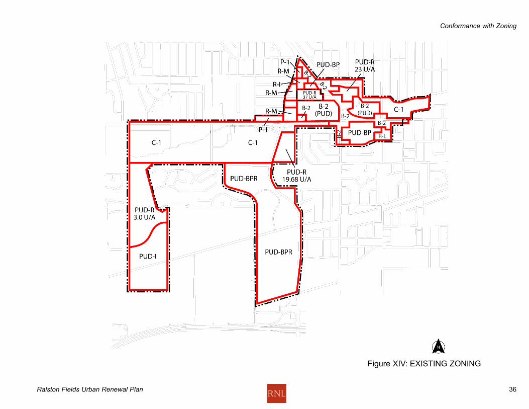
Ralston Fields Urban Renewal Plan 36
Figure XIV: EXISTING ZONING
Conformance with Zoning

Ralston Fields Urban Renewal Plan 37
Figure XV: PROPOSED ZONING
Conformance with Zoning
Ralston Fields Urban Renewal Plan 38
FinancingThe Arvada Urban Renewal Authority is authorized to finance this
project by any method authorized under the Colorado Urban
Renewal Law, which are now or will be in the future, approved by
City Charter or Colorado State Law.
AURA is authorized to issue notes and bonds in an amount
sufficient to finance all or part of this plan. The Authority is
authorized to borrow funds and create indebtedness in carrying
out this Plan. The principal and interest on such indebtedness is
to be paid from any lawfully available funds of AURA.
There are three main powers given to urban renewal authorities in
Colorado to assist them with urban renewal projects: tax
increment financing, the ability to issue bonds, and the power of
eminent domain. These are the likely tools that will be available to
AURA for the redevelopment of Ralston Fields.
Tax Increment FinancingThe primary funding mechanism available for urban renewal areas
is tax increment financing, also known as TIF. This mechanism
draws on incremental new revenues that are generated in an
urban renewal area. A base of current property and sales tax
revenues will be set at the time of approval of this Urban Renewal
Plan. This base consists of all property and sales tax revenues
that are collected from the urban renewal area by any public body.
Once that base is set, any revenues that are generated above the
base become available for urban renewal uses for a period of up
to 25 years, with adjustments for property reappraisals. These
"incremental" revenues can be used to fund improvements in the
area. Regardless of the amount of incremental revenues
generated, the base amount of revenue continues to flow to the
public bodies that were collecting it at the time of approval of the
urban renewal plan.
BondsDebt issues may include any bonds (including refunding bonds),
notes, interim certificates or receipts, temporary bonds,
certificates of indebtedness, debentures, or other obligations. It is
most common for debt to be backed by TIF revenues. An example
of this may be to issue a bond to finance the up-front costs of
redevelopment and to use the TIF dollars for repayment of the
bonds. A recent Colorado Court of Appeals decision states that
the Golden Urban Renewal Authority "is not a local government
and therefore not a district under TABOR". Given this opinion,
bonding with TIF revenues is a viable option.1
Eminent Domain Another tool available for the redevelopment of Ralston Fields is
the power of eminent domain. Eminent domain may only be used
when the sale or leasing of property for redevelopment are for
public and private uses pursuant to the Urban Renewal Plan.
Other Financing Options In addition to the financing and redevelopment options that are
explicitly available to AURA, there are numerous other tools that
may be used to support the Urban Renewal Plan. These include
special districts, working with the city on planning and zoning
changes and others. These will all be considered in implementing
the Urban Renewal Plan.
1. Colorado Court of Appeals, District V., Marian L. Olson v. City of Golden, City Council of the City ofGolden, Golden Urban Renewal Authority. It is the opinion of attorneys at Isaacson, Rosenbaum, Woods &Levy, P.C. that this decision addresses TABOR concerns around the issuance of TIF debt.
Conformance with Zoning

Ralston Fields Urban Renewal Plan 39
AURA
Ralston Fields
Site Description
September 2, 2003
THAT PART OF SECTIONS 9, 10, 15, AND 16, TOWNSHIP 3
SOUTH, RANGE 69 WEST OF THE SIXTH PRINCIPAL MERIDIAN,
CITY OF ARVADA, COUNTY OF JEFFERSON, STATE OF
COLORADO CONSISTING OF THE FOLLOWING, LOTS, TRACTS,
STREETS, UNPLATTED PARCELS AND ANNEXATION PARCELS:
1. A PORTION OF THE RIDGE HOME ANNEXATION PLAT
(RECEPTION NO. 85089854, RECORDED SEPTEMBER
19, 1985);
EXCEPT THAT PORTION LYING EAST OF THE WEST LINE OF
THE EAST 26 ACRES OF THE SOUTHEAST QUARTER OF THE
NORTHWEST QUARTER OF SAID SECTION 16 AND LYING
WEST OF THE WEST LINE OF THE NORTHEAST QUARTER OF
SAID SECTION 16 AND LYING SOUTH OF NORTH LINE OF THE
SOUTHEAST QUARTER OF THE NORTHWEST QUARTER OF
SAID SECTION 16;
AND
EXCEPT SKYLINE ESTATES FILING NO. 1 (RECEPTION NO.
F0988769, RECORDED DECEMBER 9, 1999);
AND
EXCEPT ANY PORTION OF WEST 54TH AVENUE LYING WEST
OF THE WEST RIGHT-OF-WAY LINE OF MILLER STREET.
2. A PORTION OF SKYLINE ESTATES FILING NO. 1
(RECEPTION NO. F0988769 RECORDED DECEMBER 9,
1999) CONSISTING OF: 1) TRACT L; 2) TRACT B; 3)
TRACT A: 4)TRACT D; 5) TRACT G; 6) TRACT H; 7)
TRACT I; 8) WEST 56TH PLACE RIGHT-OF-WAY; AND 9)
MILLER STREET RIGHT-OF-WAY.
3. ALL OF STENGER SPORTS COMPLEX ANNEXATION
PLAT (RECEPTION NO. F0630060, RECORDED JUNE 11,
1998).
4. A PORTION OF THE WEST 58TH AVENUE ANNEXATION
PLAT (RECEPTION NO. 87153423, RECORDED
DECEMBER 31, 1987) LYING WITHIN THE SOUTHWEST
QUARTER OF SAID SECTION 9 AND ADJACENT WEST
58TH AVENUE RIGHT-OF-WAY.
5. ALL OF THE SPORTS COMPLEX ANNEXATION PLAT
(RECEPTION NO. 925962, RECORDED OCTOBER 11,
1977) AND ADJACENT WEST 58TH AVENUE RIGHT-OF-
WAY.
6. ALL OF THE LUTZ BALL FIELD EXPANSION
ANNEXATION PLAT (RECEPTION NO. F0815833,
RECORDED MARCH 4, 1999).
7. ALL OF THE LUTZ BALL FIELD EXPANSION
ANNEXATION NO. 2 PLAT (RECEPTION NO. F0831610,
RECORDED MARCH 25, 1999).
8. ALL OF KIPLING /58 ANNEXATION PLAT (RECEPTION
NO. 87153424, RECORDED DECEMBER 31, 1987) AND
ADJACENT WEST 58TH AVENUE RIGHT-OF-WAY.
9. ALL OF WESTWARD LOOK ANNEXATION MAP
(RECEPTION NO. F1598837, RECORDED OCTOBER 31,
2002) AND ADJACENT WEST 58TH AVENUE RIGHT-OF-
WAY.
10. A PORTION OF SANDRA-TERRI SUBDIVISION
(RECEPTION NO. 665374, RECORDED DECEMBER 11,
1956) CONSISTING OF: 1) LOTS 1 AND 2, BLOCK 1; 2)
LOTS 1 AND 2, BLOCK 2; 3) LOTS 1 THROUGH 10,
BLOCK 3; AND 4) THE ADJACENT PORTIONS OF RIGHT-
OF-WAY OF WEST 53RD PLACE, WEST 53RD AVENUE
AND KIPLING STREET.
11. A PORTION OF SANDRA LYNN SUBDIVISION
(RECEPTION NO. 581419, BOOK 13, PAGE 12,
RECORDED JULY 29, 1954) CONSISTING OF THE
SOUTHWESTERLY PORTION OF LOT 29 AND 30,
(ACQUIRED AS PUBLIC RIGHT-OF-WAY BY RECEPTION
NO. 84037749 RECORDED APRIL 26, 1984 AND
RECEPTION NO. 84016264 RECORDED FEBRUARY 22,
1984) ALL OF LOTS 50 THROUGH 55, ADJACENT RIGHT-
Legal Description
Ralston Fields Urban Renewal Plan 40
OF-WAY FOR JUCHEM DITCH (RECEPTION NO.
84016265 RECORDED FEBRUARY 22, 1984) AND
ADJACENT RIGHT-OF-WAY FOR RIDGE ROAD.
12. A PORTION OF WANDA-ROSE (SUBDIVISION)
(RECEPTION NO. 728583 RECORDED SEPTEMBER 4,
1958) CONSISTING OF LOTS 1 AND 2, LOTS 32
THROUGH 37 AND THE ADJACENT RIGHT-OF-WAY
FOR KIPLING STREET, WEST 60TH AVENUE AND
ALLENDALE DRIVE (PLATTED WEST 61ST AVENUE).
13. ALL OF RALSTON PLAZA (SUBDIVISION) (RECEPTION
NO. 531875, RECORDED NOVEMBER 15, 1972) AND
ADJACENT WEST 59TH AVENUE RIGHT-OF-WAY.
14. ALL OF RALSTON VALLEY GARDENS (SUBDIVISION)
(BOOK 18, PAGE 31, RECORDED APRIL, 1958) AND
ADJACENT RIGHT-OF-WAY FOR WEST 59TH PLACE
AND KIPLING STREET.
15. ALL OF K-MART - McDONALDS SUBDIVISION
(RECEPTION NO. 82043097, RECORDED JUNE 23,
1982).
16. A PORTION OF GRANDVIEW HEIGHTS (SUBDIVISION)
ACCEPTED FOR FILING ON JULY 2, 1946) LOCATED
ENTIRELY IN THE NORTH 218 FEET OF THE
SOUTHWEST QUARTER, SOUTHWEST QUARTER,
SECTION 10, TOWNSHIP 3 SOUTH, RANGE 69 WEST,
AND ALSO LYING NORTH OF HIGHLANDS HOMES
SUBDIVISION (BOOK 14, PAGE 22, RECORDED APRIL
7, 1955) AND INCLUDING ADJACENT VACATED RIGHT-
OF-WAY FOR JOHNSON STREET, JELLISON STREET
AND IRIS STREET AND ADJACENT WEST 58TH
AVENUE AND KIPLING STREET RIGHT-OF-WAYS.
17. A PORTION OF HIGHLANDS HOMES SUBDIVISION
(BOOK 14, PAGE 22 RECORDED APRIL 7, 1955)
CONSISTING OF LOTS 84 THROUGH 89 AND
ADJACENT RIGHT-OF-WAY FOR WEST 57TH PLACE,
WEST 57TH AVENUE AND INDEPENDENCE STREET.
18. A PORTION OF ARVADA PLAZA (SUBDIVISION)
(RECEPTION NO. 862325, BOOK 22, PAGE 9
RECORDED JULY 10, 1961) CONSISTING OF TRACT A
AND RIGHT-OF-WAY FOR ADJACENT INDEPENDENCE
STREET, GARRISON STREET, WEST 58TH AVENUE
AND RALSTON ROAD.
19. A PORTION OF A REPLAT OF A PORTION OF ARVADA
PLAZA (RECEPTION NO. 031047 RECORDED
FEBRUARY 14, 1964) CONSISTING OF ALL OF BLOCK
1 AND ADJACENT WEST 57TH AVENUE.
20. A PORTION OF ARVADA SQUARE (SUBDIVISION)
(BOOK 17, PAGE 43, RECORDED JUNE, 1957)
CONSISTING OF BLOCKS 1 THROUGH 5 AND RIGHT-
OF-WAY FOR ADJACENT IRIS COURT (WEST 59TH
PLACE), HOLLAND STREET, BROOKS DRIVE,
GARRISON STREET AND RALSTON ROAD (AKA
STATE HIGHWAY 72). A PORTION OF SAID ARVADA
SQUARE WAS REPLATTED AS ARVADA SENIOR
APARTMENTS (SUBDIVISION) (RECEPTION NO.
86059835, BOOK 69, PAGE 39 AND 40, RECORDED
JUNE 4,1986) AND IS INCLUDED.
21. ALL OF SAFEWAY ADDITION TO CITY OF ARVADA
(SUBDIVISION) (RECEPTION NO. 881142 RECORDED
MAY 25, 1977) BEING A REPLAT OF PART OF BLOCK 2
AND ALL OF BLOCKS 3 AND 4 OF SAID ARVADA
SQUARE AND A PREVIOUSLY UNPLATTED PARCEL
NOW DESIGNATED AS LOT 3 AND LOT 4.
22. A PORTION OF FALK SUBDIVISION (BOOK 18, PAGE
24, RECORDED APRIL 21, 1958) CONSISTING OF LOT
11 AND ADJACENT RALSTON ROAD RIGHT-OF-WAY.
23. A PORTION OF RALSTON VALLEY GARDENS NO. 2
(SUBDIVISION) (BOOK 19, PAGE 58 RECORDED JUNE
9, 1959) CONSISTING OF ALL OF LOT 8 AND
ADJACENT RIGHT-OF-WAY FOR LEE STREET, WEST
59TH AVENUE, WEST 59TH PLACE AND KIPLING
PARKWAY.
Legal Description
Ralston Fields Urban Renewal Plan 41
24. A PORTION OF RALSTON VALLEY GARDENS NO. 3
(SUBDIVISION) (BOOK 20, PAGE 31 RECORDED
JANUARY 1960) CONSISTING OF THE NORTH HALF OF
LOT 10 AND ADJACENT LEE STREET RIGHT-OF-WAY,
THAT PORTION OF LOT 13 OBTAINED FOR KIPLING
PARKWAY RIGHT-OF-WAY, THAT PORTION OF LOT 11
RECORDED AT RECEPTION NO. 84100649 AND
ADJACENT RIGHT-OF-WAY FOR LEE STREET, WEST
58TH PLACE AND WEST 59TH AVENUE, THAT PORTION
OF THE NORTH HALF OF LOT 12 OBTAINED FOR
KIPLING PARKWAY RIGHT-OF-WAY, AND ALL OF LOT 15
AND ADJACENT RIGHT-OF-WAY FOR LEE STREET,
KIPLING PARKWAY AND WEST 58TH PLACE.
25. ALL OF A PARCEL AT 5810 MILLER STREET BEING A
PART OF THE SOUTH HALF OF LOT 12 OF SAID
RALSTON VALLEY GARDENS NO. 3 HAVING A
WARRANTY DEED - JOINT TENANCY RECORDED AT
RECEPTION NO. F0808958 AND ADJACENT MILLER
STREET RIGHT-OF-WAY.
26. ALL OF A PARCEL AT 10229 WEST 58TH AVENUE BEING
A PART OF THE SOUTH HALF OF LOT 12 OF SAID
RALSTON VALLEY GARDENS NO. 3 HAVING A
WARRANTY DEED - JOINT TENANCY RECORDED AT
RECEPTION NO. F1006516.
27. ALL OF A PARCEL AT 10203 WEST 58TH AVENUE BEING
A PART OF THE SOUTH HALF OF LOT 12 OF SAID
RALSTON VALLEY GARDENS NO. 3 HAVING A
WARRANTY DEED RECORDED AT RECEPTION NO.
88078644 AND ADJACENT KIPLING STREET RIGHT-OF-
WAY.
28. ALL OF AN UNPLATTED PARCEL AT 9901 WEST 58TH
AVENUE HAVING A SPECIAL WARRANTY DEED
RECORDED AT RECEPTION NO. F0636721.
29. ALL OF AN UNPLATTED PARCEL AT 9621 WEST 58TH
AVENUE HAVING A SPECIAL WARRANTY DEED
RECORDED AT RECEPTION NO. F1059279 AND
F0392828 AND ADJACENT INDEPENDENCE STREET
RIGHT-OF-WAY.
30. ALL OF AN UNPLATTED PARCEL AT 9611 WEST 58TH
AVENUE HAVING A SPECIAL WARRANTY DEED
RECORDED AT RECEPTION NO. F1059279.
31. ALL OF AN UNPLATTED PARCEL AT 5805
INDEPENDENCE STREET HAVING A WARRANTY DEED
RECORDED AT RECEPTION NO. 87045368 AND
ADJACENT INDEPENDENCE STREET RIGHT-OF-WAY.
32. ALL OF AN UNPLATTED PARCEL AT 9535 WEST 58TH
AVENUE HAVING A QUIT CLAIM DEED RECORDED AT
RECEPTION NO. F0316245 AND ADJACENT RALSTON
ROAD RIGHT-OF-WAY AND ADJACENT RIGHT-OF-WAY
RECORDED AT RECEPTTION NO. 79040797.
33. ALL OF A PARCEL AT 9255 WEST 57TH AVENUE HAVING
A WARRANTY DEED - JOINT TENANCY RECORDED AT
RECEPTION NO. F1297760 AND ADJACENT WEST 57TH
AVENUE RIGHT-OF-WAY.
34. ALL OF THE UNPLATTED PARCELS AT 5790 GARRISON
STREET HAVING DEEDS RECORDED AT BOOK 887,
PAGE 76 AND BOOK 956, PAGE 66 AND ADJACENT
WEST 57TH AVENUE RIGHT-OF-WAY.
35. ALL OF AN UNPLATTED PARCEL AT 9110 RALSTON
ROAD HAVING A WARRANTY DEED RECORDED AT
RECEPTION NO. F0312672 AND A QUIT CLAIM DEED -
JOINT TENANCY FILED AT RECEPTION NO. F0808278
AND ADJACENT RALSTON ROAD RIGHT-OF-WAY.
36. ALL OF A PARCEL AT 9205 WEST 58TH AVENUE HAVING
A WARRANTY DEED RECORDED AT RECEPTION NO.
F0954071 AND ADJACENT GARRISON STREET RIGHT-
OF-WAY.
37. ALL OF AN UNPLATTED PARCEL AT 9543 RALSTON
ROAD HAVING A WARRANTY DEED RECORDED AT
RECEPTION NO. F0087666 AND ADJACENT RALSTON
ROAD RIGHT-OF-WAY.
38. ALL OF AN UNPLATTED PARCEL AT 9545 RALSTON
ROAD HAVING A QUIT CLAIM DEED RECORDED AT
RECEPTION NO. 92148958 AND ADJACENT RALSTON
ROAD RIGHT-OF-WAY.
Legal Description
Ralston Fields Urban Renewal Plan 42
39. ALL OF AN UNPLATTED PARCEL AT 9555 RALSTON
ROAD HAVING A WARRANTY DEED RECORDED AT
RECEPTION NO. 93100750 AND ADJACENT RALSTON
ROAD RIGHT-OF-WAY.
40. ALL OF AN UNPLATTED PARCEL AT 9602 RALSTON
ROAD HAVING A WARRANTY DEED - JOINT TENANCY
RECORDED AT RECEPTION NO. 88010619 AND
ADJACENT RALSTON ROAD RIGHT-OF-WAY.
41. ALL OF AN UNPLATTED PARCEL AT 9601 RALSTON
ROAD HAVING A SPECIAL WARRANTY DEED
RECORDED AT RECEPTION NO. 90097444 AND
ADJACENT RALSTON ROAD RIGHT-OF-WAY.
42. ALL OF AN UNPLATTED PARCEL AT 9606 RALSTON
ROAD HAVING A WARRANTY DEED - JOINT TENANCY
RECORDED AT RECEPTION NO. F1208047.
43. ALL OF AN UNPLATTED PARCEL AT 9810 WEST 59TH
PLACE HAVING A SPECIAL WARRANTY DEED
RECORDED AT RECEPTION NO. 89085399 AND
ADJACENT WEST 59TH PLACE RIGHT-OF-WAY.
44. ALL OF AN UNPLATTED PARCEL AT 9660 RALSTON
ROAD HAVING A WARRANTY DEED RECORDED AT
RECEPTION NO. F1438233 AND A QUIT CLAIM DEED -
JOINT TENANCY RECORDED AT RECEPTION NO.
F1468282 AND ADJACENT RALSTON ROAD RIGHT-OF-
WAY.
45. ALL OF AN UNPLATTED PARCEL AT 9806 WEST 60TH
AVENUE HAVING A WARRANTY DEED RECORDED AT
RECEPTION NO. F0067735 AND ADJACENT RIGHT-OF-
WAY OF WEST 60TH AVENUE AND RALSTON ROAD.
46. ALL OF AN UNPLATTED PARCEL AT 9806 WEST 60TH
AVENUE HAVING A SPECIAL WARRANTY DEED
RECORDED AT RECEPTION NO. F0942551 AND
ADJACENT WEST 60TH AVENUE RIGHT-OF-WAY.
47. ALL OF AN UNPLATTED PARCEL AT 9999 WEST 60TH
AVENUE HAVING A DEED RECORDED AT RECEPTION
NO. 19490458.
48. ALL OF AN UNPLATTED PARCEL AT 9989 WEST 60TH
AVENUE HAVING A SPECIAL WARRANTY DEED
RECORDED AT RECEPTION NO. F0997497.
49. ALL OF AN UNPLATTED PARCEL AT 9809 WEST 60TH
AVENUE HAVING A SPECIAL WARRANTY DEED - JOINT
TENANCY RECORDED AT RECEPTION NO. F0145683
AND ADJACENT RALSTON ROAD RIGHT-OF-WAY.
50. ALL OF AN UNPLATTED PARCEL AT 9978 RALSTON
ROAD HAVING A WARRANTY DEED RECORDED AT
RECEPTION NO. F1519309 AND ADJACENT RIGHT-OF-
WAY OF RALSTON ROAD.
51. ALL OF AN UNPLATTED PARCEL AT 60TH AND KIPLING
HAVING A WARRANTY DEED RECORDED AT
RECEPTION NO. F1519309.
52. ALL OF AN UNPLATTED PARCEL AT 9998 RALSTON
ROAD HAVING A WARRANTY DEED - JOINT TENANCY
RECORDED AT RECEPTION NO. F1128340 AND THE
RIGHT-OF-WAY OF ADJACENT WEST 61ST AVENUE,
RALSTON ROAD AND KIPLING PARKWAY.
53. ALL OF AN UNPLATTED PARCEL AT 9195 RALSTON
ROAD HAVING A DEED RECORDED AT RECEPTION NO.
79100032 AND THE RIGHT-OF-WAY OF ADJACENT
GARRISON STREET AND RALSTON ROAD.
54. ALL OF AN UNPLATTED PARCEL HAVING A DEED
RECORDED AT RECEPTION NO. 594299 (BOOK 895,
PAGE 577) AND THE RIGHT-OF-WAY OF ADJACENT
GARRISON STREET, BROOKS DRIVE AND RALSTON
ROAD. THIS DEED INCLUDES AREA AT 9195 RALSTON
ROAD HAVING A DEED RECORDED AT RECEPTION NO.
70100032 (SEE ITEM NO. 53 ABOVE).
55. ALL OF LOTS 592 - 601 OF ALTA VISTA ADDITION
SUBDIVISION AND AN UNPLATTED PARCEL ALL
INCLUDED IN DEED RECORDED AT BOOK 954, PAGE
33 AND THE RIGHT-OF-WAY OF ADJACENT BROOKS
DRIVE AND RALSTON ROAD.
Legal Description

Ralston Fields Urban Renewal Plan 43
56. ALL OF AN UNPLATTED PARCEL AT 9101 RALSTON
ROAD HAVING A DEED RECORDED AT BOOK 1099,
PAGE 409, ADJACENT VACATED ESTES STREET
RIGHT-OF-WAY RECORDED AT RECEPTION NO.
80052119, THE RIGHT-OF-WAY OF ADJACENT
BROOKS DRIVE, ESTES STREET AND RALSTON
ROAD, AND AN UNPLATTED PARCEL RECORDED AT
BOOK 1410, PAGE 56.
57. FROM AND NOT A PART OF THE ARVADA RALSTON
FIELDS- PROJECT, ALTHOUGH ADJACENT TO ON ALL
FOUR SIDES, IS THE AMENDED FINAL PLAT OF
APPLECREEK (SUBDIVISION) (RECEPTION 86123256,
RECORDED OCTOBER 9, 1986).
58. EXCLUDED FROM AND NOT A PART OF THE ARVADA
RALSTON FIELDS PROJECT, ALTHOUGH ADJACENT
TO ON ALL FOUR SIDES, IS A PORTION OF RALSTON
VALLEY GARDENS NO. 3 (SUBDIVISION) (BOOK 20,
PAGE 31) CONSISTING OF THE SOUTH HALF OF LOT
10 EXCEPT THAT PORTION FOR KIPLING STREET
RIGHT-OF-WAY AS RECORDED AT RECEPTION NO.
89059788.
SAID RALSTON FIELDS SITE CONTAINING AN AREA OF 569
ACRES, MORE OR LESS.
PREPARED BY WAYNE W. HARRIS, P.E., P.L.S.
FOR AND ON BEHALF OF
MARTIN/MARTIN, INC.
12499 WEST COLFAX AVENUE
LAKEWOOD, COLORADO 80215
OCTOBER 21, 2002
REV. MARCH 26, 2003
REV. JUNE 4, 2003
REV. AUGUST 14, 2003
REV. SEPTEMBER 2, 2003
Legal Description
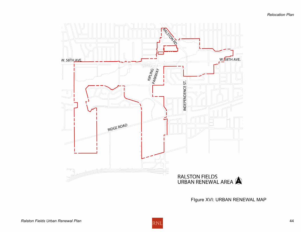
Relocation Plan
Ralston Fields Urban Renewal Plan 44
FIgure XVI: URBAN RENEWAL MAP