urban planning in sialkot - the urban unituu.urbanunit.gov.pk/documents/publications/0/117.pdf ·...
TRANSCRIPT

ADB PAK-7321
Government of Punjab Urban Unit
URBAN PLANNING IN
SIALKOT
Punjab Cities Improvement Investment Program
Final
January 2011 (J40252334)
GHK Consulting Ltd.

ADB PAK-7321
Government of Punjab Urban Unit
URBAN PLANNING IN
SIALKOT
Punjab Cities Improvement Investment Program
Final
January 2011 (J40252334)
GHK Consulting Ltd.

Urban Planning in Sialkot
Table of Contents
GHK Consulting Limited J40252334
Page i
TABLE OF CONTENTS
EXECUTIVE SUMMARY ...................................................................................................... 1
1.0 CITY PROFILE - EXISTING SITUATION .................................................................. 4 1.1. Character, Location and Natural Setting .................................................................... 4
1.1.1. Key Map ........................................................................................................ 4 1.1.2. Historical Retrospective ................................................................................. 4 1.1.3. Environment ................................................................................................... 5
1.2. Urban Socio-economy ............................................................................................... 7 1.2.1. Population and Demography .......................................................................... 7 1.2.2. Economy ........................................................................................................ 8
1.3. Urban Development .................................................................................................. 9 1.3.1. Urbanization – Historical Growth Patterns ...................................................... 9 1.3.2. Sialkot City – Land Use Patterns .................................................................... 9 1.3.3. Urban Infrastructure ..................................................................................... 12 1.3.4. Transport ..................................................................................................... 15 1.3.5. Urban Management ..................................................................................... 16
2.0 URBAN ANALYSIS – DEVELOPMENT CHALLENGES – OPPORTUNITIES AND CONSTRAINTS ...................................................................................................... 22
2.1. Regional and City Context ....................................................................................... 22 2.2. Urban Growth and Change ...................................................................................... 30
2.2.1 Patterns and Physical Features ................................................................... 31 2.3. Managing Growth and Change ................................................................................ 36
2.3.1 Outline Development Plan 1972 ................................................................... 36 2.3.2 Sialkot Master Plan 1996 ............................................................................. 36 2.3.3 Punjab Land Use Rules ............................................................................... 37 2.3.4 Current Initiatives ......................................................................................... 38 2.3.5 Key Reasons for Past Failures ..................................................................... 38
3.0 STRATEGIC DEVELOPMENT PLANNING FRAMEWORK .................................... 43 3.1. The Need for a Strategic Development Framework ................................................. 43 3.2. Approach to Preparing the SSD Framework ............................................................ 44
3.2.1 District Context and Sialkot ‗Planning Area‘ ................................................ 45 3.2.2 Population 2010 and Projections .................................................................. 47 3.2.4 Urban Land Requirements – Projected Built-up Areas ................................. 50 3.2.5 Proposed Planning Area - City Administrative Area ..................................... 52
3.3. The Strategic Planning Framework - Managing Growth and Change. ..................... 54 3.3.1 Development Vision ..................................................................................... 54 3.3.2 Future Development Scenarios .................................................................... 55
3.4. Planning Components of the Strategic Framework .................................................. 60 3.4.1 Transport System Planning .......................................................................... 60 3.4.2 Urban Corridor Planning .............................................................................. 61 3.4.3 Per-urban Planning ...................................................................................... 63 3.4.4 Commercial and Industrial Development Consolidation Planning ................. 65 3.4.5 Redevelopment Planning ............................................................................. 66
4.0 ACTION PLAN - ROAD MAP AND DELIVERY STRATEGY .................................. 70 4.1. Urban Planning Actions ........................................................................................... 70 4.2. The Next 5 Years .................................................................................................... 71 4.3. Planning and Capacity Building Action Plan ............................................................ 73
5.0 IMPLEMENTATION ................................................................................................ 80 5.1. Future Legislative and Administrative Framework ................................................... 80 5.2. Implementation Activities ......................................................................................... 81 5.3. Service Delivery ...................................................................................................... 84

Urban Planning in Sialkot
Table of Contents
GHK Consulting Limited J40252334
Page ii
A.1 POPULATION ESTIMATES AND FORECASTS .................................................... 92
TABLES
Table 1 : Monthly Climatic Information Sialkot ................................................................. 5 Table 2: Population figures for Sialkot City and Cantonment ................................................. 8 Table 3: Staffing of TO (P&C, TMA Sialkot) Office .............................................................. 17 Table 4: Divisions of Punjab Province ................................................................................. 22 Table 5: Punjab Districts Figure 5: Punjab Districts ......................................................... 24 Table 6: Population of Urban Settlements of Sialkot District ................................................ 26 Table 7: Population Projections for Urban Settlements of District Sialkot ............................ 46 Table 8: Population of Sialkot District, Tehsil and Urban Area 1972-2010 ........................... 49 Table 9: Population Projections for Sialkot Planning Area ................................................... 50 Table 10: Urban Population Projection for Sialkot City ........................................................ 50 Table 11: Projected Land Area Requirements ..................................................................... 51 Table 12: Priority Strategic Development Planning Activities – 2010-2015 .......................... 71 Table 13: Alternative Institutional Arrangements for Planning ............................................. 74 Table 14: Proposed Loan Project ........................................................................................ 77 Table 15: Proposed Plan Implementation Mechanisms ....................................................... 82 Table 16: Priority Projects 2010-18 - PCIIP Tranche 1 Projects and Base Costs .......... 84 Table 17: PCIIP Tranche 1 Consultancy Tasks and Base Costs ......................................... 85 Table 18: Summary of Outputs from Proposed Investments ............................................... 86 Table 19: PCCIP Tranche 1 Sub Project 2010-2012 Costs ................................................. 88
FIGURES
Figure 1: Sialkot Key Map ..................................................................................................... 6 Figure 2: Historical Growth of Sialkot City ........................................................................... 10 Table 5: Punjab Districts Figure 5: Punjab Districts ......................................................... 24 Figure 7: Sialkot Planning Area - A (Ex Municipal Committee) – ‗Core City‘ ........................ 28 Figure 8: Sialkot Planning Area – B (Ex Municipal Committee) – ‘Core City’ ............... 29 Figure 12: Projected Builtup Area ....................................................................................... 51 Figure 13: Proposed Planning Area ................................................................................. 53 Figure 14: Proposed Outline Development Strategy Plan ................................................... 57 Figure 15: Road Network Planning ...................................................................................... 62 Figure 16 : A Typical Peri-Urban Area – Before Planning Interventions .............................. 63 Figure 17: A Typical Peri-Urban Area – After Planning Interventions .................................. 64
TA 7321 – PAK Punjab Cities Improvement
Investment Program
Government of Punjab Urban Unit
URBAN PLANNING IN
SIALKOT
Executive Summary
January 2011
(J40252334)
GHK Consulting Ltd.

Urban Planning in Sialkot
Executive Summary
GHK Consulting Limited J40252334
Page 1
EXECUTIVE SUMMARY This report forms part of the Project Preparation Technical Assistance (PPTA) under the ADB Pakistan Investment Improvement Program (PCIIP). Under the auspices of this initiative provision is made for the procurement of contract services to undertake the comprehensive and detailed preparation of the Sialkot Strategic Development Plan (SSDP) which will constitute the Master Plan1 under the definition of GoP Local Government and Community Development Department‘s ‗Punjab Land Use Rules (2009). Furthermore, provision is also made for the preparation of an up-dated land use plan for the newly defined ‗planning area‘, city and peri-urban structure plans, outline development and/or action area plan(s) for the ‗core city ‘2 area that will also include the identification of ‗notified areas‘ and the preparation of appropriate land use redevelopment and reclassification plans .3 The proposed Strategic Development Planning Framework and Action Plan for Sialkot acts as a ‗pilot‘ initiative that will path the way for lessons learnt for adaptation and application in the other ten priority cities identified under the ADB PCIIP. This document aims to provide a springboard for further incremental action to be taken to drive the reforms and restructuring of the planning system to effectively manage the complex dynamics of future urban growth and change that Sialkot will experience. It should act as a catalyst, providing provocative views and partial answers to such questions as:- What are the trends that have shaped Sialkot today and what growth pressures will it face over the next twenty years? What can be pragmatically done to modify and redirect the future patterns of development to achieve the desired outcomes – the future ‗vision‘ for Sialkot What changes in the administrative area definitions and institutions need to be considered and adopted to effectively manage the process of growth and change? As such, it is a document that is not an end in itself. It is another step in the many that have preceded it to achieve convergence and ultimately consensus and commitment for concerted action by all stakeholders to join forces and make the planning system for Sialkot a worthy model for replication. It certainly does not profess to be a master plan or a blue print for the future, it is at best a tool that the District and Tehsil Administrations and other key stakeholders such as the Urban Unit, can use to pro-actively plan the future of the region. It is the result of a process that has sought to examine where the state of the urban development and land use management is today, where it might which to be in the future and how to get development onto the trajectory that will achieve the desired outcomes. As such its objective is to provide an integrated cross-sectional analysis of the existing situation and past trends derived from analysis of ground realities and consultations with different stakeholders. From this baseline understanding a synthesis of future options supported by recommended action and implementation measures are presented as a ‗framework‘ to be taken-up by the next stage of urban planning procurement under the ADB PCIIP. Broadly, the Sialkot Strategic Development Framework and Action Plan provides a strategic framework within which a more detailed set of plans can be elaborated and, with complementary and supportive administrative development and legislative reforms, will constitute a comprehensive planning and development management system that is able to deliver optimal benefits to today‘s and the future generations of Sialkot City.
1 Punjab Land Use Rules (2009): ‘Master Plan’ means a land use plan of an area and includes a structure plan, an outline
development plan, a spatial plan, peri-urban structure plan(s) and metropolitan plan. 2 Ex Municipal Committee Planning Area consisting of 16 Union Councils (ref Figs 7 and 8 3 Punjab Land Use Rules (2009): Ref. Chapters IV and V.
Urban Planning in Sialkot
Executive Summary
GHK Consulting Limited J40252334
Page 2
The framework developed recognises that the current forces of unbridled market forces cannot be harnessed in the short-term. Therefore, it aims to provide a pragmatic and strategic development framework within which the more detailed plans will be used to incrementally guide, manage and control future growth towards the creation of a city form that will function better as an urban economy and provide a more liveable city for its citizens. To this end, the model of development advocated is a poly-centric, metropolitan city that will have at its centre a core city with a distinctive identity, efficiently connected through an integrated concentric and radial highway network to secondary and tertiary sub-centres and associated commercial and industrial clusters built-on the competitive advantage of their local economic development profile strengths. It is foreseen that within this overarching structure, that the peri-urban centres and commercial/industrial clusters within the metropolitan planning area will be compact, enabling the release and reservation of interstitial lands as an inter-linked open space system containing recreation and low density metro-level education and health facilities. Two ‗grand plan‘ concepts are also advocated for consideration: i) the creation of a Regional Parkway between the Upper Chanab and Marala Ravi canals between the Siakot-Sambrial and Marala-Airport Roads, and ii) that both the Siakot-Sambrial and Marala-Airport Rod corridors are considered for the development of rapid transit schemes.

TA 7321 – PAK Punjab Cities Improvement
Investment Program
Government of Punjab Urban Unit
Part A
Section 1
CITY PROFILE - EXISTING SITUATION
January 2011
(J40252334)
GHK Consulting Ltd.
Urban Planning in Sialkot Part A – Section 1
City Profile - Existing Situation
GHK Consulting Limited J40252334
Page 4
1.0 CITY PROFILE - EXISTING SITUATION
1.1. Character, Location and Natural Setting
1.1.1. Key Map
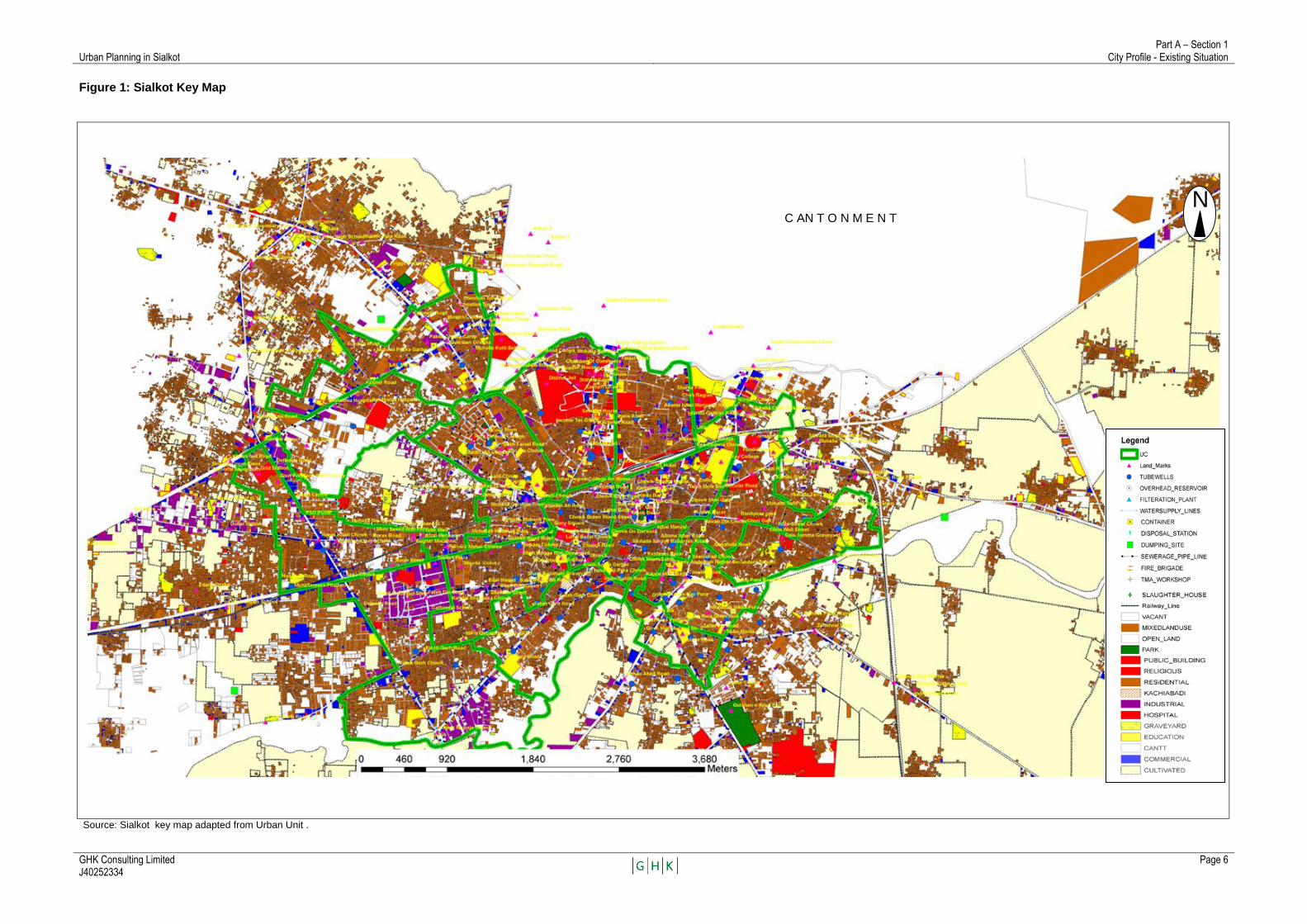
The key map is reproduced Figure 1 and presents a detail land use plan of the area known as the Ex-Municipal Committee urban area which excludes the Cantonment.
The official terminology for the key plan is Land Use Classification Plan as per the Punjab Land Use Rules4. This establishes the status quo in terms of land use at a particular time and acts as a benchmark to officially scrutinize, approve and notify proposed changes in land use.
Since the current version of the ‗key plan‘ only covers the Ex MC area (termed the ‗core city‘ in this report), it will need significant augmentation in its area coverage to provide this land use classification reference frame for the proposed new Sialkot Planning Area for which it is foreseen will in the next 20 years extend many times greater than what can be currently considered the Sialkot Planning Area5. Provision is made for the preparation of this, what is essentially a district-wide, extended Planning Area under the Punjab Land Use Rules – Ref Chapter III, article 36
―Preparation of a district planning map – A City District Government or a District Government shall prepare a district planning map by combining the notified planning maps of the Towns or Tehsils of the district‖
1.1.2. Historical Retrospective
There are various sources tracing the origins of the city of Sialkot but the authenticity of many of these sources varies. Excavations throughout the area have revealed large amounts of Greek coins, ancient Zoroastrian temples and several Buddhist stupas.
It is generally agreed that the history of Sialkot may be divided into eight eras: Vedic Era - when it is ruled by the Raja Sul (Sala a dynasty and founder of Sialkot (named Sakala) some 5000 years ago.
Persian Greek Era – the city was the eastern most outpost of Alexander the Great Hellenic Empire comprising Persians and Greeks. During 160 and 135 BC Sialkot acted as one of the capitals of Indo-Greek Empire.
Scythian Hun Era – when the city was ruled by Raja Sáliváhan who belonged to a caste named as ‗Sia‘, a jut clan of Scythian origins who built a fort and gave city a name of Sialkot. During the last quarter of 5th century Huns sacked the city. After that phase it is believed that it remained part of Jammu ruler named as Raja Bahram Deo.
Muslim Mughal Era - starts when Shahab-ud-Din Muhammad Ghauri conquered Punjab in 1011 and dissolved the city as a part of the Muslim Sultanate of Delhi. After that this city came under rule of Mughal Empire of India and was considered a part of Lahore Province. Afghan Pastuns Era - after the end of Mughal reign it came under the rule of Pastun families from Khandar and became part of the Afghan empire.
4 Government of Punjab, Local Government and Community Development Department, notified Land Use Rules (2009)
5 Ex Municipal Committee are (17 Union Councils), Cantonment, plus contiguous urban and associated peri-urban areas.
Urban Planning in Sialkot Part A – Section 1
City Profile - Existing Situation
GHK Consulting Limited J40252334
Page 5
Sikh British Era - Sikhs gain control of this city from pastuns and ruled for 40 years untill the Second Anglo-Sikh War in 1849 when Sialkot was captured by British.
Pakistan Movement Era - Allama Iqbal (national poet of Pakistan, born in Sialkot) spearheaded the movement for an independent country. In May 1944 the Sialkot Convention became the historic event that catapulted the All India Muslim League into prominence in the British-Indian Punjab.
Modern Era - Pakistan was founded during 1947 after which Sialkot has gradually become a major industrial city of Pakistan (ref. 1.2.2 Economy and industry).
1.1.3. Environment
Climate
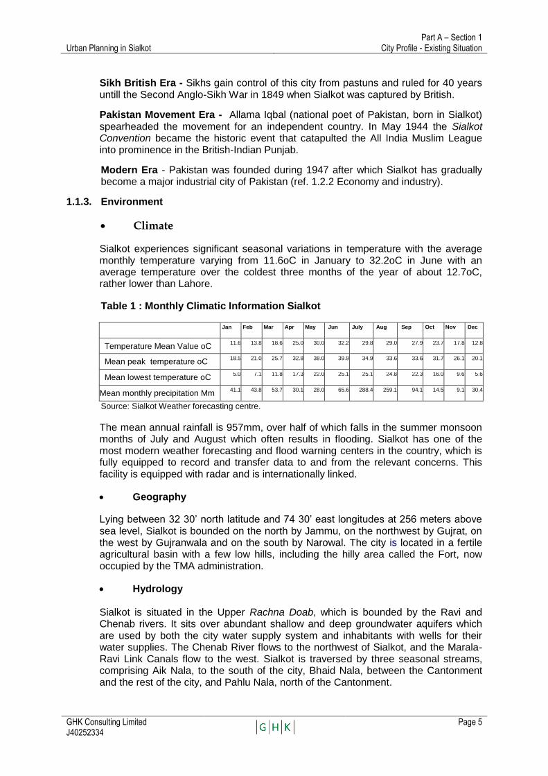
Sialkot experiences significant seasonal variations in temperature with the average monthly temperature varying from 11.6oC in January to 32.2oC in June with an average temperature over the coldest three months of the year of about 12.7oC, rather lower than Lahore.
Table 1 : Monthly Climatic Information Sialkot
Jan Feb Mar Apr May Jun July Aug Sep Oct Nov Dec
Temperature Mean Value oC 11.6 13.8 18.6 25.0 30.0 32.2 29.8 29.0 27.9 23.7 17.8 12.8
Mean peak temperature oC 18.5 21.0 25.7 32.8 38.0 39.9 34.9 33.6 33.6 31.7 26.1 20.1
Mean lowest temperature oC 5.0 7.1 11.8 17.3 22.0 25.1 25.1 24.8 22.3 16.0 9.6 5.6
Mean monthly precipitation Mm 41.1 43.8 53.7 30.1 28.0 65.6 288.4 259.1 94.1 14.5 9.1 30.4
Source: Sialkot Weather forecasting centre.
The mean annual rainfall is 957mm, over half of which falls in the summer monsoon months of July and August which often results in flooding. Sialkot has one of the most modern weather forecasting and flood warning centers in the country, which is fully equipped to record and transfer data to and from the relevant concerns. This facility is equipped with radar and is internationally linked.
Geography
Lying between 32 30‘ north latitude and 74 30‘ east longitudes at 256 meters above sea level, Sialkot is bounded on the north by Jammu, on the northwest by Gujrat, on the west by Gujranwala and on the south by Narowal. The city is located in a fertile agricultural basin with a few low hills, including the hilly area called the Fort, now occupied by the TMA administration.
Hydrology
Sialkot is situated in the Upper Rachna Doab, which is bounded by the Ravi and Chenab rivers. It sits over abundant shallow and deep groundwater aquifers which are used by both the city water supply system and inhabitants with wells for their water supplies. The Chenab River flows to the northwest of Sialkot, and the Marala-Ravi Link Canals flow to the west. Sialkot is traversed by three seasonal streams, comprising Aik Nala, to the south of the city, Bhaid Nala, between the Cantonment and the rest of the city, and Pahlu Nala, north of the Cantonment.
Urban Planning in Sialkot Part A – Section 1
City Profile - Existing Situation
GHK Consulting Limited J40252334
Page 6
Figure 1: Sialkot Key Map
Source: Sialkot key map adapted from Urban Unit .
C AN T O N M E N T
N

Urban Planning in Sialkot Part A – Section 1
City Profile - Existing Situation
GHK Consulting Limited J40252334
Page 7
The general slop of the land within the Doab is to the south-west and the area is an active flood plain, although floods are to a large extent controlled by irrigation and power generation works carried out on the Indian side of the border.
Geology and Ecology
Geology - he area is underlain by Pleistocene deposits to a depth of several thousand meters. The first 200metres of these deposits consist of approximately 70% silty sand interspersed with limited clay layers. The strata are generally heterogeneous with little vertical or lateral continuity. The historic centre of Sialkot is located between two seasonal watercourses, the Bhaid Nullah and the Aik Nullah. It occupies land that is elevated up to about 10 meters above the surrounding areas. Apart from the central area, the city is generally flat. Overall, there is an east to west fall, from around 253 meters in the east to about 245 meters in the west, an average fall of about 1 in 1000.
Ecology - the Sialkot District has been a part of the ecological zone called thorn forest but with the introduction of extensive irrigation network of canals for development of agriculture, industrial development and urbanization has changed its biological features. Most of the part of the district is now agriculture zone with human related or human dependent fauna and flora and for the most part of the district is now an agricultural zone.
About 2.17 % of the total area of the district is under human forest plantation of trees of economic importance like Shisham, Keeker, Mulberry that are used in construction and making sports goods and furniture. Other introduced species are Mesquite an invasive species and Safeda Sheesham Bohar and Bakain are also seen in and around the urban areas. The district Sialkot is the host of a variety of flora. The indigenous tress are Lasoora, Bairy, Siris, Keeker, Phali, Khajoor, Toot and Paper Mulberry These are commonly found along the edges of agricultural fields.
About 54 km2 of the Bajwat region in the Sialkot District is the Bajwat Game Reserve. About 16 km2 of the area around Marala Headworks is also protected within the game reserve and is of considerable importance for wintering waterfowl.
Fortunately, from a planning perspective all development activities foreseen under PCIIP will be far away from these environmentally sensitive areas and will therefore not be adversely affected by any of the proposed interventions.
1.2. Urban Socio-economy
Sialkot is located close to the Indian border some 125 km north of Lahore. It is a major industrial centre, specializing in leather products, surgical instruments, diesel engines, pharmaceuticals, steel rolling mills, textiles and sports goods. There are at least 264 tanneries, 244 leather garment producing units, 900 leather sports goods producing units, 57 rice husking mills and 14 flour mills in the city. These industries produce significant quantities of highly polluted wastewater.
1.2.1. Population and Demography
Census population figures for Sialkot City and Sialkot Cantonment are displayed in Table 2, together with the estimated growth rates.

Urban Planning in Sialkot Part A – Section 1
City Profile - Existing Situation
GHK Consulting Limited J40252334
Page 8
Table 2: Population figures for Sialkot City and Cantonment
Census population
Average growth rates (%)
Projected 2010
population 1972 1981 1998 1972 -81 1981 – 98
Ex MC area 204,000 258,147 358,376 2.65 1.95 471428
Cantonment 43.862 63,126 2.16 78990
Peripheral areas
362135
Combined 302,009 421,502 912,553
Source: District Census Report 1998.
The 362135 figure for peripheral areas relates to the population living beyond the pre-2001 municipal limits. It has been estimated on the basis of average population density and the extent of the built-up area beyond the city limits. The population of the Sialkot city (Ex MC area and Cantonment) is estimated to be about 550418 with an average population density of around 1160/km2. Historically the population growth rate at an average of 2.5% is relatively low compared to other urban areas of Pakistan. This is illustrated by the fact that in 1941, Sialkot was the 6th largest city in Pakistan (150,000) and in 1998 it was the 13th largest City. The population mainly consists of Punjabis, Kashmiris and Pashtuns and Punjabi is the main language of people. Sialkot has also attracted many laborers and other entrepreneurs many of whom hail from Pakistan's Federally Administered Tribal Areas (FATA), notably from Bajaur and Mohmand who have set up vibrant business throughout the area and the literacy rate is among the highest in Pakistan at 73% in urban areas and 54% in rural areas and employment in agriculture is only 19.5% and 32% in elementary occupations.
1.2.2. Economy
The history of industrialization of Sialkot is very old. The Damascene craftsmen of Sialkot (koftgars or koftars) were famous during the Mughal era for their fine swords and daggers. Papermaking in Sialkot dates back to the time of the Mughal Emperor Akbar which was famous all over the world. Brick making was another historic skill of the people of the Sialkot and those bricks were known as the "Sialkoti Bricks" throughout South Asia. Most of the states in the South Asian region relied on the slender but strong Sialkoti brickslanateer for the erection of forts, castles, monuments, public buildings, infrastructure construction, etc. Nowadays, Sialkot is famous all over the world because of its sports equipment and Surgical Instruments manufacturing industry. The most successful sports manufacturing firms now have international collaborations with the well-known sports brands like Adidas (Germany), Puma (Germany), Nexo Sports (Canada), Nike (USA), Dita (UK), Mikasa Sports (Japan) and Slazenger (UK). In the recent past, however, lack of modernization and allegations of child labor usage have resulted in a loss of market share to the new entrants in the business like Thailand, Korea and China. The Sialkot Chamber of Commerce and Industry has now almost controlled the incidents of child labor usage within the industry with the collaboration of the United Nations (ILO). Most of the companies have adopted the ISO standards. The facilities of a dry port and recently built airport have contributed significantly towards its economic growth and Sialkot is now the third largest economic hub in Punjab after Lahore and Faisalabad. It is commercially linked with the Lahore Stock Exchange through its Sialkot branch, known as the Sialkot Trading Floor (STF). The State Bank of Pakistan and the Export Promotion Bureau of Pakistan has branch

Urban Planning in Sialkot Part A – Section 1
City Profile - Existing Situation
GHK Consulting Limited J40252334
Page 9
offices in Sialkot. After Karachi, Sialkot is Pakistan's second largest source of foreign exchange earnings through its exports and remittances from the overseas manpower. For the past several decades, the manufacturers and exporters of the city have been awarded the annual National Exports Award by the Federation of Pakistan Chambers of Commerce and Industry. Sialkot has an Industrial Estate and an Export Processing Zone. Another Export Processing Zone is planned along the Sialkot Lahore Motorway. The per capita income of Sialkot is ranked among the highest in Pakistan.
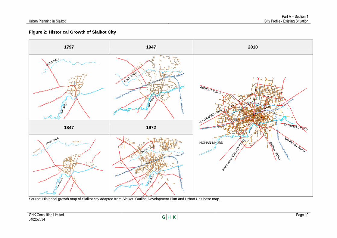
1.3. Urban Development 1.3.1. Urbanization – Historical Growth Patterns (Ref. Figure 2)
Around the year 1797 AD, Sialkot was a small settlement centered on the Fort just north of Aik Nullah. Over the next 100 years it expanded slightly to the north, and a railway was constructed which crosses the city from east to west. After partition in the year 1947 the city began to expand, mainly towards the north, as the Cantonment became more significant, and also towards the north-west in the direction of Bhaid Nullah. By the 1970s, the city had significantly densified and expanded up to Bhaid Nullah, and substantial development of the area north of Bhaid Nullah, centered around the Cantonment, had become much more pronounced. More recently, the city has grown in a westward direction along the major inter-city roads radiating out of Sialkot and along Defense Road.
1.3.2. Sialkot City – Land Use Patterns
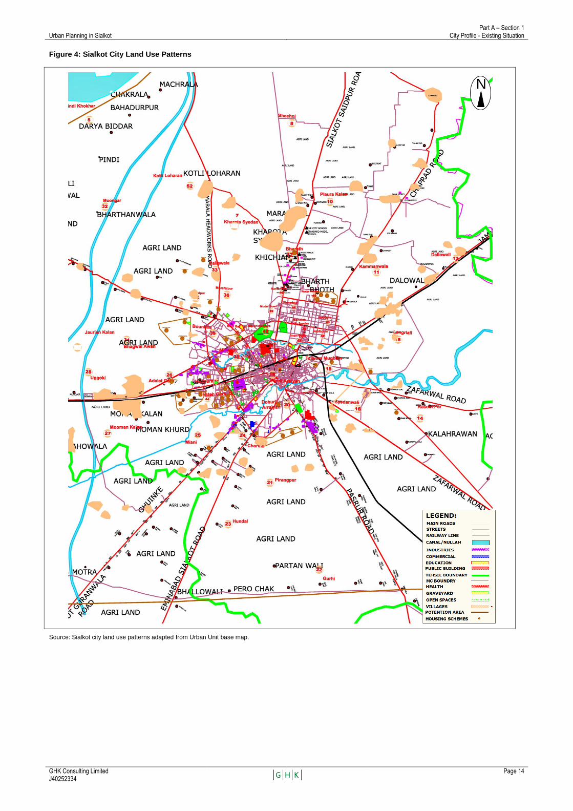
Land uses in Sialkot City are mixed, and in many cases incompatible. Sialkot would benefit from stronger land use controls, to prevent potentially harmful activities from being located near residential areas and vice versa. Sialkot has very few green areas or parks, with the most prominent being Gulshan-e-Iqbal park, off Narowal Road, a park in the Cantonment and the stadium. There is a need for more open spaces, more space for industrial activities and a better-defined road network, in both core city and contiguous areas. The main land use patterns of Sialkot City are displayed in Figure 3 on the following page. Eleven arterial roads radiate out from the Sialkot City centre and link it with surrounding agricultural areas, other cities and Sialkot International Airport which lies about 20 km to the west of the City Centre.
Industrial Land Uses Industries have developed in a ribbon pattern along all of the north, west and south radial roads, as have housing estates. Agricultural communities close to the roads and to industries are fast becoming urbanised. Whereas industrial land uses within the central city are scattered throughout the area in Wazirabad Road and in the small Industries estates along Haji Pura, Daska, Emanabad, Narowal, Defense, Kullowal roads and north of the Railway Station. Commercial land uses, once concentrated in the area around the fort, are now found in outlying areas such as Defense Rd., Paris Rd., Saddar in the Cantonment and along major roads.
Urban Planning in Sialkot Part A – Section 1
City Profile - Existing Situation
GHK Consulting Limited J40252334
Page 10
Figure 2: Historical Growth of Sialkot City
1797 1947 2010
1847 1972
Source: Historical growth map of Sialkot city adapted from Sialkot Outline Development Plan and Urban Unit base map.
AIK
NALA
BHED NALA
BHED N
ALA
AIK
NALA
BHARTH
ZAFARWAL ROAD
PASRUR R
OAD
EMIN
ABAD S
IALK
OT
ROAD
AIRPORT ROAD
ZAFARWAL ROAD
MOMAN KHURD
AIK
NALA
BHED NAL
A
WAZIR
ABAD ROAD
AIK
NALA
BHED NALA
BHED N
ALA
BHED NALA
AIK
NALA
BHED NALA
Urban Planning in Sialkot Part A – Section 1
City Profile - Existing Situation
GHK Consulting Limited J40252334
Page 11
There are about 3,000 large, medium and selected small industries in Sialkot District, some located in the central city areas and many along the arterial roads leading out of the city. Together, they employ about 22,300 persons. Industries located along Gujranwala Road include Redo factory, Micro Corporation, Europlus, Saga Sports, Taj Mahal Factory, Phonix Cutlery, Remix Factory, Tata Sports, Motor Bike Apparel, numerous leather goods factories, Awan Sports, Taylon Industries, Pakol Industry and many more. Sambrial Road has significant tanneries along it, particularly between the two canals, east of the Dry Port. On Pasrur Road, there are mixed land uses along the segment closer to Sialkot urban area, but there are many rice mills along the outer segments of this road. There are however no significant developments along Eminabad Road and Zafarwal Road outside urban limits. There is an industrial complex in Sambrial, in vicinity of the airport. This includes an export processing zone, a dry port and a number of industries around it and all along Wazirabad Road, which passes through Sambrial. These industrial developments, as stated earlier, are near the airport. An industrial estate for tanneries is also proposed near the airport. For this purpose, an area of 155 hectares (384 acres) has been acquired.
Commercial The city has a number of commercial areas including the area immediately north of the Fort. In addition to the older, more traditional areas high-end commercial, financial and related activities have been developed, making the city, once single-centered on the commercial areas around the fort, now multi-cantered.
Institutional Institutional land uses are also prominent, in areas such as Katchary Road, Beetshania Hospital, Allama Iqbal Memorial Hospital, the WAPDA offices and similar areas.
Sialkot has a fairly well-developed educational infrastructure that comprises a sub-campus of the Fatima Jinnah Women University, a sub-campus of the Virtual University of Pakistan, 8 Degree Colleges for Women, 5 Degree Colleges for Men, 2 Cadet Colleges, 6 Commerce Colleges, one Law College, one Medical College, one Homeopathic Medical College, one Nursing School, one Para-Medical School, one Poly-Technic Institute, with numerous Inter Colleges, Higher Secondary Schools and over 250 High Schools. The University of Engineering Sciences and Technology (UEST) was recently established in collaboration with the Royal Institute of Technology, Sweden on the Sialkot Lahore Motorway and will also incorporate the development of a Technology Park.
Open Space
Sialkot has very few green areas or parks, with the most prominent being Gulshan-e-Iqbal park, off Narowal Road, a park in the Cantonment and the stadium. As the urban population increases and along with that, urban densities, the need to aspire to setting open space standards and reserving lands to meet these ambitions, becomes increasingly urgent.
Urban Planning in Sialkot Part A – Section 1
City Profile - Existing Situation
GHK Consulting Limited J40252334
Page 12
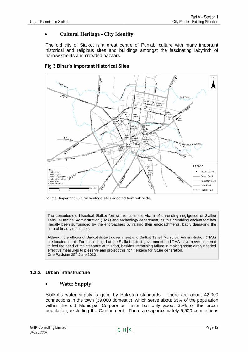
Cultural Heritage - City Identity The old city of Sialkot is a great centre of Punjabi culture with many important historical and religious sites and buildings amongst the fascinating labyrinth of narrow streets and crowded bazaars. Fig 3 Bihar’s Important Historical Sites
Source: Important cultural heritage sites adopted from wikipedia
The centuries-old historical Sialkot fort still remains the victim of un-ending negligence of Sialkot Tehsil Municipal Administration (TMA) and archeology department, as this crumbling ancient fort has illegally been surrounded by the encroachers by raising their encroachments, badly damaging the natural beauty of this fort. Although the offices of Sialkot district government and Sialkot Tehsil Municipal Administration (TMA) are located in this Fort since long, but the Sialkot district government and TMA have never bothered to feel the need of maintenance of this fort, besides, remaining failure in making some direly needed effective measures to preserve and protect this rich heritage for future generation. One Pakistan 25
th June 2010
1.3.3. Urban Infrastructure
Water Supply
Sialkot‘s water supply is good by Pakistan standards. There are about 42,000 connections in the town (39,000 domestic), which serve about 65% of the population within the old Municipal Corporation limits but only about 35% of the urban population, excluding the Cantonment. There are approximately 5,500 connections
Urban Planning in Sialkot Part A – Section 1
City Profile - Existing Situation
GHK Consulting Limited J40252334
Page 13
in the Cantonment, covering an estimated 38,500 people or about 47.5% of the civilian .population of the Cantonment. The TMA estimates that the existing distribution system covers about 70% of the area within the pre-2001 municipal limits. The available information on the extent of distribution mains suggests that the potential coverage within the pre-2001 municipal limits is close to 100%. The difference between the area and population coverage in this area suggests that there is scope to make new connections within it. There are currently no connections outside the pre-2001 municipal limits so there is greater scope for providing new connections in this area.
Sewerage, Drainage and Wastewater Disposal Sialkot is partly sewered and partly served by open and covered drains. The sewers are in poor condition and blocked in many places. The main system served the centre of the city and the area to the west, discharging to a 54‖ diameter trunk sewer along Roras Road. Unfortunately the main pumping stations serving the city centre system are no longer operationally effective and as a result much of the wastewater from the city centre is being discharged via a covered drain. Two further pumping stations are provided to pump wastewater into the Bhaid Nullah during monsoon conditions but it appears that these pumping stations are required infrequently. There is no separate storm system. Roadside drains along main roads are described as storm drains but actually carry both storm and foul flows.
Solid Waste Management
Sialkot‘s solid waste management (SWM) system is in a state of disarray. Of the 125,000 tons per year of municipal solid waste generated, only 25 percent enters the municipal waste system, leaving 75 percent of the population without waste collection. Practically all municipal waste is either burned, dumped or buried illicitly on vacant land throughout the city, causing significant environmental damage and posing a health hazard..
Urban Planning in Sialkot Part A – Section 1
City Profile - Existing Situation
GHK Consulting Limited J40252334
Page 14
Figure 4: Sialkot City Land Use Patterns
Source: Sialkot city land use patterns adapted from Urban Unit base map.
N
Urban Planning in Sialkot Part A – Section 1
City Profile - Existing Situation
GHK Consulting Limited J40252334
Page 15
1.3.4. Transport
Road Networks
Sialkot is about two hours from Lahore and four hours from Islamabad. Sialkot is linked with the National Highway N-5 through Gujranwala and Wazirabad. A dual carriage-way is available between Sialkot and Wazirabad. A new bridge on the Chenab River, called the Shahbazpur Bridge, is under construction these days which is located to the north-east of Gujrat. Once completed, it will connect Sialkot to N-5 at Gujrat. The Sialkot Lahore Motorway (M-11) is also under construction. All the bus and commuter coach stations are located on the Jail Road. A bus service operated by Daewoo Express is available from Sialkot to Rawalpindi, Lahore, Gujranwala and Multan
Public Transport
Recently, public transport has been launched in Sialkot on one route which circle around the city. SCCI Sialkot Chamber of Commerce & Industry has signed an MOU with American bus company FOTON to provide air-conditioned local transport to the citizens with CNG fuel. However main mode of transport within the city at present is the auto rickshaw. Although no proper taxi service exists in the city, there are many rent-a-car service outlets.
Traffic Management
Although the road network in the city is well developed and recently executed road improvements carried through joint efforts of Sialkot Chambers of Commerce and Industry (SCCI) and the Government has resulted in improved road surface conditions in most of city areas, the main problems lies in traffic management. Road junction layouts, utilization of road space, absence of pedestrian facilities, uncontrolled road side parking and absence of enforcement of traffic regulatory control measures result in congestion and . Additionally, irrespective of the public transit initiative referenced above, public transport overall is inadequately developed with only two formal bus routes operating in the city.
Rail Transport
Sialkot is served by Pakistan Railways through the Sialkot Junction. Sialkot used to be a junction in the British era with trains leaving for Jammu and Gurdaspur. Plans are under consideration to open the border for an international train between Sialkot and Jammu. Express trains to and from Narowal, Lahore, Rawalpindi, Faisalabad, Multan, Bahawalpur and Karachi are available daily. The Railway station is situated in the centre of the city. Other suburban train stations are Ugoki and Sambrial.
Air Transport
Sialkot International Airport is the first-ever private-sector airport of Pakistan managed by the SIAL consortium. It is located near Sambrial and is noted for having the longest runway in Pakistan. Direct flights are available from Sialkot International Airport to Karachi, Islamabad, Abu Dhabi Sharjah & London, Muscat Kuwait, Dubai & Jeddah. Pakistan International Airlines has plans to start non-stop flights from Sialkot to Manchester, London & Barcellona & Hajj flights have started from the Sialkot International Airport last year in 2009. Emirates is also expected to start flights in
Urban Planning in Sialkot Part A – Section 1
City Profile - Existing Situation
GHK Consulting Limited J40252334
Page 16
mid-2010 to Dubai. Airblue will operate on domestic routes to Islamabad, Multan and Karachi in mid-2010. A small Sialkot Cantonment Airport, located in the Sialkot Cantonment, is in use of the aviation wing of the Pakistan Army. This airport has also been used as a public airport by PIA for operating a Helicopter service from Sialkot to Islamabad in 1995-1996.
Dry Port Sialkot Dry Port carries the honour of being the first-ever private-sector dry port in Asia. It was established in 1986 near Sambrial, about 20 km from the Sialkot city under the control of the Sialkot Dry Port Trust.
1.3.5. Urban Management
The urban planning processes in Pakistan suffer from inadequacy of appropriate legislation covering all town planning issues. Existing planning documents and guidelines are rarely consulted and projects are approved without observance of planning principles and practices. As a result major cities are growing in an unplanned haphazard way.
Present Planning Framework
The growth of Sialkot has been since 1972 guided by the following planning interventions: • An Outline Development Plan and Zoning Plan, covering the period 1972
1987; • Building byelaws; • A ban on new industrial land within 5 km of the city centre; • A private housing act; and • Other actions such as permissions given by TMA for commercialization along
major roads. As described by the TO (Planning and Control), planning consideration of major schemes is now usually guided not by a plan but by a consideration of surrounding and adjoining land uses. When a request for planning permission is received, the TO conducts a survey of nearby developments and prepares a recommendation based upon maintaining compatible land uses and preventing potential land use conflicts. When a major scheme is not involved, the major control mechanism is the building permit. This involves first checking the setback, building height and other aspects of the lot layout against the byelaws and then reviewing the proposed construction of the building. The impact of the ban on development of new industries close to the city centre has been described above. In the absence of new industrial zones industries have chosen to locate along the major road corridors leading out of the city. There are, as far as is known, no planning permissions involved in the subdivision of properties, except where a scheme is involved prior to the application for a building permit. The result is that, in practice, planning controls are exercised very late in the land development process. Requests for permission are seldom turned down, and

Urban Planning in Sialkot Part A – Section 1
City Profile - Existing Situation
GHK Consulting Limited J40252334
Page 17
then only when it is expected that approval would result in a high risk of harm to the surrounding area or population.
Commercialization of land uses along major roads is subject to a fee of 20% of the commercial land value, and has become a major source of revenue to the TMA. However, there is little in the way of an objective basis for issuance of commercialization permits which are presently issued more with the objective of generating revenues than with the objective of achieving compatible land uses. Although TMAs are able to control some land uses proposed by private parties, those proposed by higher levels of government are usually beyond their control. Federal and provincial government agencies may ask for planning approval before undertaking projects, but this appears to be a voluntary rather than a mandatory requirement. It appears there is little or no true public consultation about either plans or planning decisions. Without such consultation, it will be difficult except in the most extreme circumstances to frame planning decisions that will have the desired impact on development. Unless public consensus underlies planning decisions, powerful investors will seek, and receive, special treatment, because decisions made based upon technocratic considerations will always be weaker than decisions based upon popular consensus of what constitutes the public good. The capacity of TMA Sialkot to prepare plans and implement planning decisions is extremely limited. The present staffing of the TO‘s office is severely limited to shown in Table 3. With a very limited staff, the TO (P&C) processes about 1,000 building permits and a half dozen or so housing estate permits a year. It has no capacity to prepare plans, and only very limited capacity to process permits. Particularly where these are for larger projects, or for more complex situations, the office is severely short-staffed.
Table 3: Staffing of TO (P&C, TMA Sialkot) Office
Position Sanctioned Filled Comment
Tehsil Officer Planning and Coordination 1 1 Na
Assistant Tehsil Officer Planning and Coordination 1 0 Open for six years
Building Inspectors 3 0 On loan from TO (I)
Draftsmen 2 1 Na
Senior Clerk 1 1 Na
Junior Clerk 1 1 Na
Patwari 1 1 Na
Surveyor 1 1 Na
Tracer 1 1 Na
Peons 2 2 Na
Total 14 9 Na
Source: Sialkot TMA schedule of establishment 2010-2011.
Planning is currently practiced by both the District and the TMA. However, the capacity of both units of government is severely limited. The TMA, for example, has only 1 planning officer and 3 building inspectors, all on loan from another department, to process about 1,000 building applications each year, and this leaves scant resources for any other activity.
Urban Planning in Sialkot Part A – Section 1
City Profile - Existing Situation
GHK Consulting Limited J40252334
Page 18
The ratio of planners to population in Sialkot is therefore about 1 per million persons, whereas in a typical city in the developed world6 it may be on the order of 1 per 10,000 persons, giving the developed world city 100 times the planning capacity of Sialkot. To present the issue of development control from another perspective, the city of Sialkot, with a 2010 population of 912553 persons and 129,000 households, growing at 3.4 percent per annum, and with many existing structures being rebuilt, generates a need for 4,000-5,000 building permits per year. Only about 20% of building projects are being submitted for review, further illustrating the limited capacity of the present system.
Current Legislative Framework
Under Section 69 of Pakistan Local Government Ordinance (PLGO) 2001 the concerned local council is required to draw a spatial/master plan for the area under its control. Under the provision (Section) 54-A preparation and enforcement of spatial/master plan is the function of the TMAs. Approval of the spatial/master plan is the function of City District Government, but every tier of City District Governments has the power to prepare the master plans. Therefore, there is a need to introduce Comprehensive Town Planning legislation that will clearly differentiate, authorize and empower different levels of Local Government to implement their plans within their respective jurisdictions. PLGO 2001 was designed to address four specific areas of concern including flawed urban-rural divide, bureaucratic control, out-dated urban development policies and lack of coordination. However after over 8 years experience indicates that the situation in each of these four areas under PLGO 2001 has actually gone from bad to worse7.
The most common comment with respect to spatial planning and controls is the multiplicity of same functions to all tiers of the city government resulting in overlapping jurisdictions and powers .But none have the capacity and capability of preparing and implementing spatial/master plans, in particular at the level of the TMAs.
Many agencies play both a policy-setting and service delivery role, leaving little room for effective oversight of their performance. Separating the role of policy-making and regulation from service delivery, and improving the political and institutional accountability of: (i) Urban Councils to the Provincial Government; (ii) Service Delivery entities to the Urban Councils; and, (iii) Urban Councils to the citizens is thus central to improving the performance of cities.
6 In 2007 in Scotland the average permanent full-time staff employed in local authority Planning and Economic
Development departments was 0.8 per 1,000 resident population or, pro-rata, 800 per million people. 7 Local Government and Community Development Department, Government of Punjab


TA 7321 – PAK Punjab Cities Improvement
Investment Program
Government of Punjab Urban Unit
Part A
Section 2
CITY PROFILE - SITUATION ANALYSIS
January 2011
(J40252334)
GHK Consulting Ltd.


Urban Planning in Sialkot Part A – Section 2
City Profile - Situation Analysis
GHK Consulting Limited J40252334
Page 22
2.0 URBAN ANALYSIS – DEVELOPMENT CHALLENGES – OPPORTUNITIES AND CONSTRAINTS
Until about three decades ago, Pakistan‘s cities were compact and cantered upon a civic administrative or commercial core. Now in Sialkot, as in other intermediate cities of similar sizes, industrial, commercial and housing developments are expanding and radiating out along major transport corridors. What were previously small rural settlements are becoming engulfed as contiguous areas to the cities built-up areas and the interstitial areas between the radials then coalesce to form extensive areas of urban sprawl. The predominance of central place functions becomes less dominant as mobility and spending power increase, economic linkages strengthen and newly emerging commercial, institutional and servicing functions emerge; incrementally making the urban form less cantered and more multi-nodal and metropolitan in character.
2.1. Regional and City Context
For the preparation of the Sialkot Strategic Development Framework and Action Plan It is firstly necessary to have an understanding of the different spatial and administrative references and contexts within which it will need to be considered. The dynamics of urbanisation in Pakistan at a macro-regional level have been profound and it is recognised that cities with the characteristics of Sialkot have the potential to be developed in a way which can help to alleviate the over burdensome growth of the mega cities of Pakistan.
As far back as 1998 the Pakistan Development Review under an article entitled 'urbanisation of everybody', institutional imperatives, and social transformation in Pakistan‘ wrote: .....two clusters of contiguous districts in Pakistan whose rural population densities are 400 persons or more per sq. kin. These are Pakistan's ruralopolises. The larger one is in Punjab spread across the eastern half of the province--from Sialkot to Multan, an area 55,738 sq. km. It is a densely settled region dotted with cities, towns and sprawled villages and hamlets. In this region, one can travel along any road and never be out of sight of a house, village or workshop. Towns and cities may be distant but the human settlement is always nearby. From Gujrat to Lahore and then onward to Multan, one is always in urban presence. Spatially this area is one extended urbanising region, one ruralopolis. The second ruralopolis is centred around Peshawar and extends across Peshawar Valley and beyond into the lower reaches of Swat Valley. Karachi to Hydrabad is already a corridor of urban settlements.
At the top of the hierarchy is Punjab as a Province of Pakistan. Punjab Province has 9 Divisional Administrative regions: (3rd tier of government)
Table 4: Divisions of Punjab Province
Division and Capital Area km2
Bahawalpur 45.588
Dera Ghazi Khan 38,778
Faisalabad 17,917
Gujranwala 17,206
Lahore 16,104
Multan 21,137
Rawalpindi 22,255
Sergodha 26,360
Sahiwal N.A. Source: Information adopted from wikipedia
At next level of the Punjab administrative structure are the districts. There are 36 districts in Punjab Province:

Urban Planning in Sialkot Part A – Section 2
City Profile - Situation Analysis
GHK Consulting Limited J40252334
Page 23
Urban Planning in Sialkot Part A – Section 2
City Profile - Situation Analysis
GHK Consulting Limited J40252334
Page 24
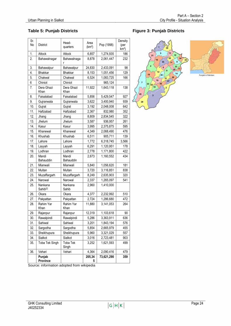
Table 5: Punjab Districts Figure 3: Punjab Districts
Sr. No.
District Head-quarters
Area (km²)
Pop (1998) Density
(per km²)
1. Attock Attock 6,857 1,274,935 186
2. Bahawalnagar Bahawalnagar
8,878 2,061,447 232
3. Bahawalpur Bahawalpur 24,830 2,433,091 98
4. Bhakkar Bhakkar 8,153 1,051,456 129
5. Chakwal Chakwal 6,524 1,083,725 166
6 Chiniot Chiniot 965,124
7. Dera Ghazi Khan
Dera Ghazi Khan
11,922 1,643,118 138
8. Faisalabad Faisalabad 5,856 5,429,547 927
9. Gujranwala Gujranwala 3,622 3,400,940 939
10. Gujrat Gujrat 3,192 2,048,008 642
11. Hafizabad Hafizabad 2,367 832,980 352
12. Jhang Jhang 8,809 2,834,545 322
13. Jhelum Jhelum 3,587 936,957 261
14. Kasur Kasur 3,995 2,375,875 595
15. Khanewal Khanewal 4,349 2,068,490 476
16. Khushab Khushab 6,511 905,711 139
17. Lahore Lahore 1,772 6,318,745 3,566
18. Layyah Layyah 6,291 1,120,951 178
19. Lodhran Lodhran 2,778 1,171,800 422
20. Mandi Bahauddin
Mandi Bahauddin
2,673 1,160,552 434
21. Mianwali Mianwali 5,840 1,056,620 181
22. Multan Multan 3,720 3,116,851 838
23. Muzaffargarh Muzaffargarh 8,249 2,635,903 320
24. Narowal Narowal 2,337 1,265,097 541
25. Nankana Sahib[2]
Nankana Sahib
2,960 1,410,000
26. Okara Okara 4,377 2,232,992 510
27. Pakpattan Pakpattan 2,724 1,286,680 472
28. Rahim Yar Khan
Rahim Yar Khan
11,880 3,141,053 264
29. Rajanpur Rajanpur 12,319 1,103,618 90
30. Rawalpindi Rawalpindi 5,286 3,363,911 636
31. Sahiwal Sahiwal 3,201 1,843,194 576
32. Sargodha Sargodha 5,854 2,665,979 455
33. Sheikhupura Sheikhupura 5,960 3,321,029 557
34. Sialkot Sialkot 3,016 2,723,481 903
35. Toba Tek Singh Toba Tek Singh
3,252 1,621,593 499
36. Vehari Vehari 4,364 2,090,416 479
Punjab Province
205,345
73,621,290 359
Source: information adopted from wikipedia

Urban Planning in Sialkot Part A – Section 2
City Profile - Situation Analysis
GHK Consulting Limited J40252334
Page 25
Sialkot District
Sialkot District (Zila) comes under Gujranwala Division and is one of 36 administrative districts within Punjab Province. The total population of the entire Sialkot District, which was 2.7 million in 1998, is estimated to be about 3.6 million in 2010, growing at 2.66% per annum.
Source: Adaptation of web site ma
Fig. 6 Sialkot District

Urban Planning in Sialkot Part A – Section 2
City Profile - Situation Analysis
GHK Consulting Limited J40252334
Page 26
Sialkot District is divided into the four Tehsils (administrative areas) of Daska, Pasrur, Sambrial and Sialkot. The present urban population of Sialkot Tehsil is estimated to be around 0.912 million, about 27% of the total for the District. The urban population of Sialkot District live principally in 10 urban centres including the Sialkot urban area. The other urban centres in Sialkot District include Daska, Sambrial, Pasrur, Chawinda, Jamke Cheema, Kotli Loharan, Bhopalwala, Kalaswala and Begowala. The population of the urban settlements of Sialkot District is presented in Table 6. There has been a marginal increase in the proportion of the urban population of Tehsil Daska (20.38% in 1998, 25..82% in 2010)and in Tehsil Pasrur (13.04% in 1998, 14.62% in 2010 and newly established Tehsil Sambrial 25% in 1998, 28.91 in 2010 ). However, in case of Tehsil Sialkot, where the functionally urban area population has been estimated, there has been a considerable increase from 29% in 1998 to about 32% in 2010 which signifies a on-going and rapid rate of urbanisation.
Table 6: Population of Urban Settlements of Sialkot District Tehsil Estimated
Tehsil Population
(2010)
Urban Settlements
Population of urbanSettlements
(2010)
Estimated Urban
Population (2010)
% Urban Population-
2010
% Urban Population-
1998
Daska 715000 Daska 158,923 184,615 25.82 20.38
Jamke Cheema
25,692
Pasrur 754000 Pasrur 68,013 110,256 14.62 13.04
Chawinda 29,315
Kalaswala 12,928
Sambrial 378000 Sambrial 81,690 109,268 28.91 25.06
Bhopalwala 18,997
Begowala 8,581
Sialkot 1588000 Sialkot 527427 550418 34.66 28.82
Kotli Loharan 22991
District Total
3435000 954557 954557 27.79 26.51
Source : Punjab Development Statistics 2010
Sialkot Tehsil
Sialkot Tehsil contains 50 Union Councils but has essentially only two urban centres i.e. Sialkot and Kotli Loharan and is estimated to have a population of about 1.58 million. However, Kotli Loharan is a small urban settlement with an administrative area population of only about 22991, implying that almost the entire urban population (0.912 million) of Tehsil Sialkot is concentrated into Central Sialkot (Sialkot Ex MC Planning Area, Cantonment and the immediate surrounding urbanised areas).
Urban Planning in Sialkot Part A – Section 2
City Profile - Situation Analysis
GHK Consulting Limited J40252334
Page 27
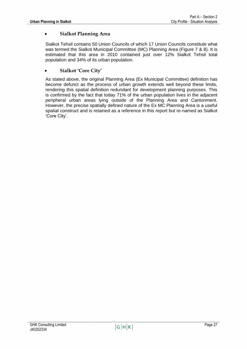
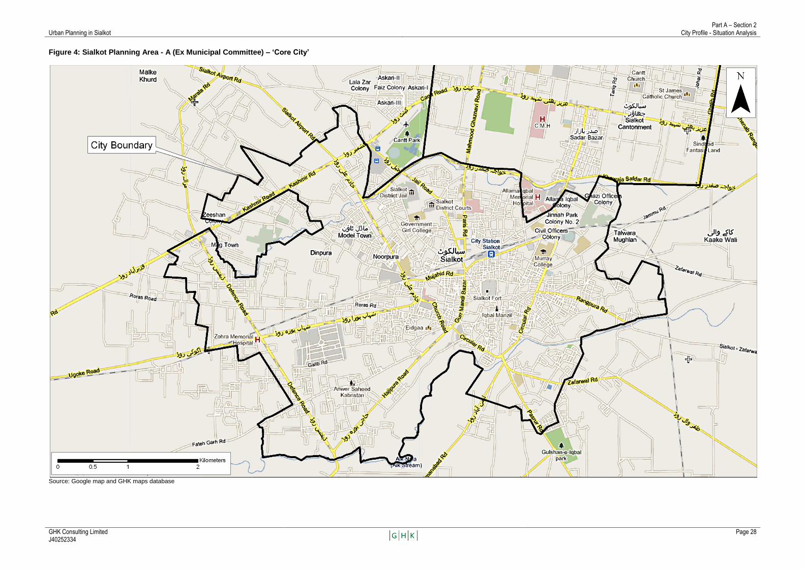
Sialkot Planning Area
Sialkot Tehsil contains 50 Union Councils of which 17 Union Councils constitute what was termed the Sialkot Municipal Committee (MC) Planning Area (Figure 7 & 8). It is estimated that this area in 2010 contained just over 12% Sialkot Tehsil total population and 34% of its urban population.
Sialkot ‘Core City’
As stated above, the original Planning Area (Ex Municipal Committee) definition has become defunct as the process of urban growth extends well beyond these limits, rendering this spatial definition redundant for development planning purposes. This is confirmed by the fact that today 71% of the urban population lives in the adjacent peripheral urban areas lying outside of the Planning Area and Cantonment. However, the precise spatially defined nature of the Ex MC Planning Area is a useful spatial construct and is retained as a reference in this report but re-named as Sialkot ‗Core City‘.
Urban Planning in Sialkot Part A – Section 2
City Profile - Situation Analysis
GHK Consulting Limited J40252334
Page 28
Figure 4: Sialkot Planning Area - A (Ex Municipal Committee) – ‘Core City’
Source: Google map and GHK maps database
Urban Planning in Sialkot Part A – Section 2
City Profile - Situation Analysis
GHK Consulting Limited J40252334
Page 29
Figure 5: Sialkot Planning Area – B (Ex Municipal Committee) – ‘Core City’
Source: Adopted from Urban Unit Sialkot base map.
N
Legend
UC Boundary Core City Boundary

Urban Planning in Sialkot Part A – Section 2
City Profile - Situation Analysis
GHK Consulting Limited J40252334
Page 30
Sialkot City
A more meaningful term: ‗Sialkot City‘, has been adopted for future planning purposes that encompass the Ex MC area, Cantonment and the immediate surrounding peripheral urban areas. The population for this area in 2010 is estimated to slightly in excess of 0.9 million. Meaning that about 57% of Sialkot Tehsil‘s total population is urban (34% of the District is urban), and almost all of this is concentrated in and within the adjacent urbanized area of the ‗Core City‘. Significantly, since 1998, the share of urban population for Sialkot Tehsil has increased far more rapidly compared to the other tehsils. This serves to illustrate that the rate of urbanisation into Sialkot City continues to be greater than other urban centres in the District.
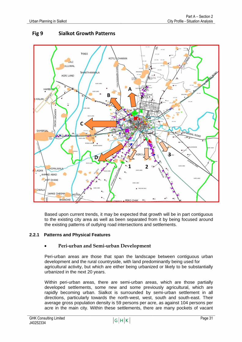
2.2. Urban Growth and Change (ref. Fig 9)
Until about three decades ago, Pakistan‘s cities were compact and cantered upon a civic administrative or commercial core. Now in Sialkot, as in other intermediate cities of similar sizes, industrial, commercial and housing developments are expanding and radiating out along major transport corridors.
Although Sialkot is expanding in all directions, the major thrust is towards north-west, west and south (Figure 10). The expansion towards north and east is restricted because of the Cantonment and the Indian border. Industrial expansion is extensive along major inter-City roads radiating out of Sialkot, though mainly in a sporadic manner, trapping fertile agricultural land in between.
The present growth trend of Sialkot is likely to continue, expanding more towards north-west and south-west, consolidating on the residential and commercial developments are already taking place in that direction. The ‗pull and push‘ forces created by the proximity to the Cantonment and the airport will encourage this trend to continue in future with most of the growth been absorbed in the following westerly corridors:
A. Kotli Loharan Road – Marala Road B. Marala Road - Airport Road C. Airport Road – Wazirabad Road. D. Wazirabad Road and Gujranwala Road
Although to a lesser extent than west, additional growth will also take place towards south in areas falling between the following roads:
1. Gujranwala Road-Eminabad Road 2. Eminabad Road-Pasrur Road 3. Pasrur Road-Zafarwal Road
Urban Planning in Sialkot Part A – Section 2
City Profile - Situation Analysis
GHK Consulting Limited J40252334
Page 31
Fig 9 Sialkot Growth Patterns
Based upon current trends, it may be expected that growth will be in part contiguous to the existing city area as well as been separated from it by being focused around the existing patterns of outlying road intersections and settlements.
2.2.1 Patterns and Physical Features
Peri-urban and Semi-urban Development
Peri-urban areas are those that span the landscape between contiguous urban development and the rural countryside, with land predominantly being used for agricultural activity, but which are either being urbanized or likely to be substantially urbanized in the next 20 years. Within peri-urban areas, there are semi-urban areas, which are those partially developed settlements, some new and some previously agricultural, which are rapidly becoming urban. Sialkot is surrounded by semi-urban settlement in all directions, particularly towards the north-west, west, south and south-east. Their average gross population density is 59 persons per acre, as against 104 persons per acre in the main city. Within these settlements, there are many pockets of vacant
A B
C
1 2
D 3
Urban Planning in Sialkot Part A – Section 2
City Profile - Situation Analysis
GHK Consulting Limited J40252334
Page 32
lands and hence potential for in-fill development. Although these pockets are predominantly agricultural at present, it can be anticipated that they will become semi-urban and then possibly urban as the city expands.
Agricultural communities have been distinguished from urban communities based upon their distance from major roads and employment centres, housing and infrastructure characteristics as read out from Google Earth. This delineation is preliminary and should be confirmed as planning for the city is continued and deepened in its content. A close examination of the semi-urban and peri-urban areas around Sialkot reveals that they generally suffer from a lack of a well-defined road network. They have grown organically, and hence the road network has extended in response to this growth.
Ribbon Development
There are extensive developments along major roads connecting Sialkot to other cities. A broad-brush land use survey along these roads was conducted by the Consultants during last week of March, 2010. These roads included Gujranwala Road, Sambrial Road, Eminabad Road, Pasrur Road and Zafarwal Road. Most of these roads have extensive developments along them, in some cases well beyond the tehsil limits of Sialkot. The land uses are mixed, particularly along the road segments closer to the core city, but industries dominate while moving further away from Sialkot.
Industrial Developments
It appears that industries are choosing outlying locations for several reasons: (i) there has been a ban on development of new industries within 5 km of the city centre; (ii) the land in outlying areas, even along major transport corridors, is less costly than land nearer the city centre; and (iii) such locations provide access to the road network for industry outputs, inputs and labour.
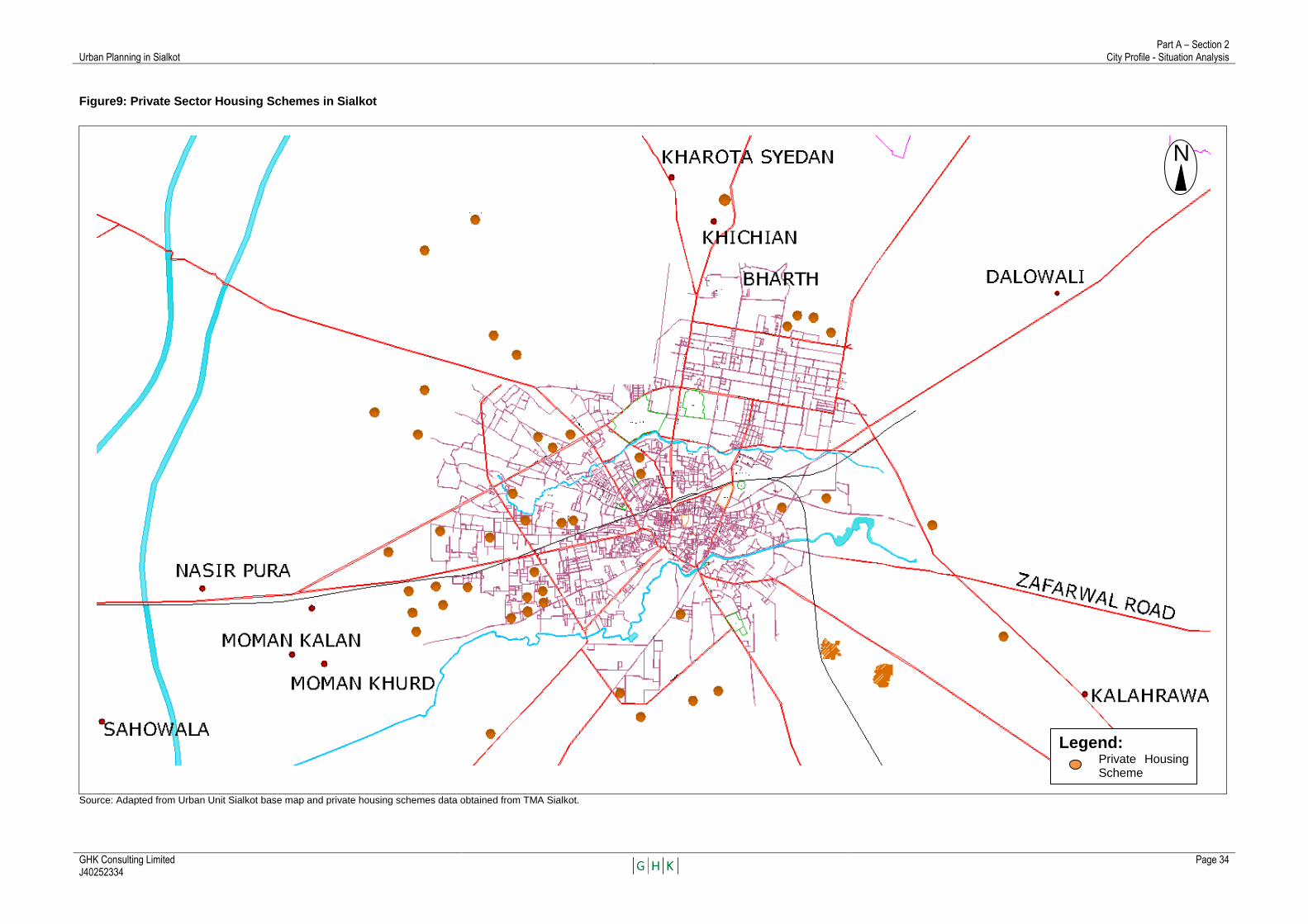
Private Sector Housing Schemes
Data obtained from TMA Sialkot shows that housing 56 private housing schemes are currently under development in the City (Figure 10) . The aggregate area under these schemes is 3,575 kanals, or about 447 acres, while the average area per scheme is about 64 kanals, or 8 acres. Most of these Schemes are located towards west of the existing city, along roads heading southwest, west and northwest of the city. They extend as far as the airport area. Assuming a gross density of 50 persons per acre, these schemes would only provide housing for 22,350 persons, about half of one year‘s growth of the city. Since the full development and occupation of these schemes will take 5-10 years, it may be judged that they will provide housing for only about 5-10% of the growth that is occurring. Most housing in the city is built individually, by the private individuals who will occupy it.
Among the 56 private schemes, the developers sought approval for only 26 schemes from TMA and for the remaining 30 schemes sought approval only from the Revenue Department. Among the 26 schemes with TMA, 4 have been approved, 2 have been given initial approval and final clearance for these 2 is awaited from TMA‘s Scrutiny Committee. Under the PLGO2001, approval of housing schemes is a function of TMA and not Revenue Department. Technically therefore, the 30 schemes with Revenue

Urban Planning in Sialkot Part A – Section 2
City Profile - Situation Analysis
GHK Consulting Limited J40252334
Page 33
must also be approved by the TMA to be considered ‗approved‘ in the sense of having gone through a planning decision process.
Urban Planning in Sialkot Part A – Section 2
City Profile - Situation Analysis
GHK Consulting Limited J40252334
Page 34
Figure9: Private Sector Housing Schemes in Sialkot
Source: Adapted from Urban Unit Sialkot base map and private housing schemes data obtained from TMA Sialkot.
Legend: Private Housing Scheme
N
Urban Planning in Sialkot Part A – Section 2
City Profile - Situation Analysis
GHK Consulting Limited J40252334
Page 35
2.2.2 Sialkot’s Urbanisation Dynamics
What were previously small rural settlements are becoming engulfed as contiguous areas to the cities built-up areas and the interstitial areas between the radials then coalesce to form extensive areas of urban sprawl. The predominance of central place functions becomes less dominant as mobility and spending power increase, economic linkages strengthen and newly emerging commercial, institutional and servicing functions emerge; incrementally making the urban form less centered and more multi-nodal and metropolitan in character.
Rural-urban linkages
Sialkot‘s rural-urban linkages are been increasingly strengthened. The city serves as a market for agricultural products and many of Sialkot‘s workers live in nearby small towns and agricultural villages, which are thereby becoming functionally urban. On the other hand, Sialkot tehsil contains very substantial agricultural areas, many of which will remain agricultural even as the city grows and expands.
Under PLGO 2001 the urban rural distinction was eliminated which resulted in amalgamation of the boundary between urban & rural areas, with consequential lack of focused attention on either of the two.
Limits to Growth The new growth pattern trends are well underway and presents both positive potentials and negative challenges:
On the positive side this ribbon-like, informal development brings onto the market land that is easily accessible and able to be developed at a relatively low cost. It takes advantage of the efficiencies offered by the new transport infrastructure.
On the negative side, ribbon expansion increases travel and infrastructure servicing costs. As development infills laterally, extensive areas of unplanned urban sprawl are created. Unless these forces of development are positively harnessed, their consolidation will result in extensive radial development that will be increasingly difficult to regularize and service.
The city has grown far past its historical limits, suggesting that the pre-2001 municipal boundaries are irrelevant for planning purposes. These arguments imply that to develop a comprehensive understanding of the spatial growth and dynamics of a city, an understanding of its hinterland, its population growth and its spatial expansion trends are required. The area within the pre-2001 municipal limits is mostly developed. One exception to this general rule is an area between Kashmir Road and the Bhaid Nullah, east of Defense Road and including the Mag Town development, which consists mostly of open plots.
Urban Planning in Sialkot Part A – Section 2
City Profile - Situation Analysis
GHK Consulting Limited J40252334
Page 36
2.3. Managing Growth and Change
Past efforts at planning in Sialkot have failed, and present capacity for planning and development control is limited and ineffective. Past efforts include:
2.3.1 Outline Development Plan 1972
In the absence of a newer plan, it is believed that the 1972 Outline Development Plan and Zoning Plan are still in effect. Although they were in many respects well-prepared, they were over-ambitious in its assumption that it would be able to effectively guide and control development. For example,
• The population projection of 248,000 persons by 1987 assumed growth at only 1.5% per annum, below the national population growth rate at that time; it was exceeded by 1980;
• The proposed ring road was only partly constructed and development leapfrogged over it;
• Proposed industrial zones were ignored;
• The only substantial park in Sialkot came up in a location not anticipated in the plan;
• Proposed greenbelt areas were not implemented;
• In many areas, proposed low density housing development in fact became high density development as market forces were dominant; and
• The Zoning Plan did not anticipate the commercial development that occurred and continues to develop along major roads.
In 1985, consultants prepared a Master Plan for Sialkot, but it appears neither to have been translated into a zoning plan nor to have been adopted. The 1972 Plan, therefore, stands as an example of how important it is to understand market forces, an example of how difficult it is to control development, and a warning that to attempt too much in the way of controls is to put the anticipated plan outcomes at risk.
2.3.2 Sialkot Master Plan 1996
The Master Plan of 1996 was prepared under World Bank Funded ‗Feasibility Studies and Urban Master Planning of Ten Cities of Punjab‘ The plan period was 20 years (1994-2019). The Plan aimed to maintain its cultural and industrial nature and its westward and southward growth. The plan proposed to exploit the scenic quality of Aik and Bher channels, supplement civic facilities and conserve the southern orchards (which then existed) and the central hillock as a historic core. The plan highlights mixed land uses which are quite pronounced in Sialkot, with haphazard residential, industrial, and commercial activities taking place in different
Urban Planning in Sialkot Part A – Section 2
City Profile - Situation Analysis
GHK Consulting Limited J40252334
Page 37
localities. The plan recommended the placement of functional uses on a natural growth axis to the south and west following a policy of concentrated growth rather than a possibly more costly policy of dispersed growth. A series of concentric roads were proposed to ensure continuity and encourage economic and compact city development. A new CBD was proposed between Lahore Road and Eminabad Road. A grain market exists along Pasrur bypass. New fruit & vegetable markets and other wholesale establishments were also proposed here under the 1996 plan. The fruit orchards along Eminabad Road were proposed to be preserved. A sports complex was proposed between Sahwala Road and Aik Nala. Two industrial estates were proposed, one along Lahore Road (822 acres) and the other along Wazirabad Road (277 acres).
In the Master Plan of 1996, both fertility and migration rates were expected to decrease and the outlying residential communities were anticipated to merge into the expanding municipal boundary. Accordingly, under the medium growth scenario, the population of Sialkot was projected to be 838,908 by the year 2019. Under the PCIIP project, however, the urban population of Sialkot by the year 2020 is projected to be around 1.28 million. This is understandable because the 1996 forecasts were only for the core area; in fact large tracts of land even within core area were vacant. As against that, at present the stated area has not only filled-up but there has been a hefty spill-over. Besides, population of cantonment has also been included. Thus for population forecasts, the 1996 Plan focused on core area, while the forecasts under PCIIP are for the entire Sialkot (core area, area urbanised outside the core area and the cantonment).
The Master Plan of 1996 was not adopted, though some of its recommendations are still valid. Sialkot, as envisaged in 1996 plan, continues to expand towards west and south. The fruit orchards along the Eminabad Road which were proposed to be conserved, are no more there. The proposed sports complex was not established, nor was the proposed industrial estates along Lahore Road and Wazirabad Road, nor was the proposed green belt along Defence Road.
The reasons for non-adoption of the Master Plan of 1996 are not fully known, but it is apparent from discussions with both city administrators and others that neither was the Plan extensively discussed in the public arena, nor was it followed by the more detailed studies necessary to move from a strategic plan to a plan upon which planning decisions could be based. An examination of actual development trends versus plan proposals reveals some of the core deficiencies of the process followed: the various plan prescriptions (a new CBD, industrial zones, a sports complex and open spaces) were so far-reaching, and so ambitious, that they required by their very nature extensive public debate and discussion, which did not occur; and even had this debate occurred, it is possible that they may have been beyond the financial resources of the city to implement them.
2.3.3 Punjab Land Use Rules
Recognizing the ineffectiveness of present urban planning practice in Pakistan, the Punjab Land Use Rules (2009) were prepared in an effort to learn from the past by creating a comprehensive system for the classification and reclassification of land use, formally introducing concepts such as plan maps, peri-urban local plans and road corridor plans, reclassification and redevelopment schemes, and linking the planning process with land use conversion permissions. The Rules have been

Urban Planning in Sialkot Part A – Section 2
City Profile - Situation Analysis
GHK Consulting Limited J40252334
Page 38
notified province-wide and are in use in Lahore. Training is being provided to staff of other cities in their use, and land use classification mapping is underway. Although the Rules, as intended, create a comprehensive planning system, they would, if fully implemented in the near future also require resources that are far in excess of those likely to be available in Sialkot. In later sections of this report, the consultants propose a carefully programmed implementation of the Rules, so as to make their application consistent with the human resources likely to be available in Sialkot over the next several decades.
2.3.4 Current Initiatives
In addition to the Rules, a number of other initiatives are underway, most of them developed by the Urban Unit. Satellite imagery has been collected for Sialkot and other urban centres, and topographic, land use and infrastructure maps are being prepared from the imagery. It is intended that this and other information will be assembled into a geographic information system (GIS) for each city. The consultants have been informed that the GIS system is fully funded. For purpose of land use classification, however, a land use survey should be organized at least every five years.
The Urban Unit has prepared maps of central Sialkot that show all land uses (residential, commercial, industrial, institutional, etc) plot by plot, and plot boundaries. It is expected that these will be used to identify non-conforming land uses, and as a basis for improved property taxation. This mapping is now being extended to cover the entire urban area.
Methods are being considered of improving urban property taxation, using the information collected through property mapping and land use surveys. If property taxation can be improved, it will serve as an important influence on property values.
It can be said that Sialkot currently operates under building byelaws and a private housing act that follows standard Punjab urban planning practice.
2.3.5 Key Reasons for Past Failures
It is worthwhile reflecting on some of the key reasons for the failure of past efforts as ‗lessons learnt‘ and an indication of where efforts will need to be focused to make this new initiative a success:
Rationalizing institutional framework still marred by overlapping jurisdictions and powers.
Streamlining legal provisions pertaining to the nature of plan, and plan approval, review and monitoring arrangements.
Developing institutionalised coordination mechanisms particularly to link the decision making processes about budgets, and infrastructure improvement and development with those of land management. This will also help ensuring transparency as well as accountability.
Capacity building of agencies responsible for implementation of the new Plan both, by deputing additional technical staff, and through periodic training of the staff.
Adoption of the strategy to first prioritize the proposals contained in the new Plan and then implement them accordingly.
The prioritization of proposals should be done keeping in view the real needs of the people of Sialkot resources available and capacity to implement them.
Urban Planning in Sialkot Part A – Section 2
City Profile - Situation Analysis
GHK Consulting Limited J40252334
Page 39
Availability of adequate financial resources particularly for smooth and timely acquisition of land for public sector development projects.
Generating political will to have due regard to the proposals of the new Plan through orientation/briefing to the elected representatives about the Plan and its role in achieving quality of life for the present and future generations, dissemination of progress of implementation of the plan, and creating awareness among the communities.
The pre-conditions cited above are not new but what now really needed is serious thought and sincere effort to ensure effective implementation.


TA 7321 – PAK Punjab Cities Improvement
Investment Program
Government of Punjab Urban Unit
Part B
Section 3
STRATEGIC DEVELOPMENT PLANNING FRAMEWORK
January 2011
(J40252334)
GHK Consulting Ltd.

Urban Planning in Sialkot Part B – Section 3
Strategic Development Planning Framework
GHK Consulting Limited J40252334
Page 43
PART-B: SSD FRAMEWORK & ACTION PLAN The Sialkot SDP Framework and Action Plan as the tile suggests is composed of two principle sections:
Strategic Development Framework - A vision and strategy to set the parameters as a basis to adjust and guide the physical development of the city in response to growth trends and the identification and evaluation of alternative growth strategies and definition of the spatial planning areas that are included under the Framework.
Action Plan - A program of action to conduct effective planning, sequenced in time, and defined in content, cost and funding.
The purpose of the first is to help get preparation of more detailed physical plans under the ADB PCIIP loan project off to a fast start. The purpose of the latter is to guide the necessary preparatory and supportive actions necessary for the planning of Sialkot. It is foreseen that this will act as a demonstration project for refinement and replication in the other 10 cities prioritised under the PCIIP.
STRATEGIC DEVELOPMENT PLANNING FRAMEWORK
2.4. The Need for a Strategic Development Framework Past efforts at planning in Sialkot have failed, and present capacity for planning and development control is limited and ineffective. The main reasons for these failures and shortfalls is the lack of public involvement in planning, unrealistic planning, lack of a governance system that engages the skills and knowledge of the private sector, and lack of implementation mechanisms consistent with the capacity of planning agencies. Many of the building blocks for an effective planning process are in place but they lack a framework within which they are able to be effectively integrated into a planning system. While efforts at public sector-led planning have proven ineffective, the Chamber of Commerce and Industry has successfully undertaken planning for major projects, including the international airport, a new industrial zone near the airport and other infrastructure including a road project. This indicates that it is neither lack of awareness of the need for planning, nor lack of capacity for planning in the population at large that underlie the lack of planning. Rather, it is the lack of a connect between public sector led efforts at planning, and of a governance structure for planning that would make use of the readily apparent skills and knowledge of the private sector. It is reasonable to conclude that it is timely for the success of the ADB PCIIP8 public sector service delivery initiative to engender greater public support and private sector engagement for the development process in Sialkot and the other target cities in the District. In turn, this will act as a stimulus to development, creating conditions that will need a complimentary and realistic strategic planning framework. As a first step to driving forward the process of preparing and implementing a new and more relevant
8 Punjab Cities Investment Improvement Program (PCIIP) aimed at promoting institutional reforms and
human resource development for improved service delivery and financial management
Urban Planning in Sialkot Part B – Section 3
Strategic Development Planning Framework
GHK Consulting Limited J40252334
Page 44
planning regime, this will be critical as a tool to motivate and guide development to deliver the desired outcomes. Without this initial planning framework, the danger is that development will accelerate and respond purely to market forces, exacerbating and compounding the negative urban impacts that are already apparent. That said, it would be totally unrealistic to imagine that a ‗plan‘ of any kind will have any affect on harnessing market forces in the short-term. The Sialkot Strategic Development (SSD) Framework aims to initiate the next stages of the plan-making process that will guide and control future development to shift it onto a trajectory that will incrementally achieve the desired short and medium-term goals and objects and ultimately the overarching ‗vision‘ for Sialkot. The SSDP does not attempt to propose a master plan or blueprint for the future development of Sialkot. That would neither be desirable nor possible given the limited time and resources available at this stage in the plan-making process. Master plans tend to be over prescriptive and inflexible in response to change. Time and resources far in excess of those available to the consultants are required for their preparation. Instead a more pragmatic approach has been adopted that builds on reviewing and understanding past trends and issues as a basis for the preparation of an outline strategic planning framework which includes recommendations for the preparation of a structure plan and an action plan for creating a new, more effective planning process and planning institutions.
2.5. Approach to Preparing the SSD9 Framework
The approach adopted for the preparation of the Sialkot Strategic Development Planning Framework is based around defining the future spatial envelopes that are likely to circumscribe the land that will be necessary to contain the population and related land use activities at certain future dates (2020 and 2030). The steps to doing this can be summarised as:
Existing Situation – past trends and the existing urban conditions are set out and described in Part A of this report as the baseline parameters for future projects and forecasts.
District Context and Sialkot ‘Planning Area’ - the rationale for the establishment of an overarching district-wide strategic context within which the Sialkot Planning Area is defined.
Population Growth - based upon past trend projections modified according to future forecasts of natural growth rates, urban settlement and migration patterns that are considered most likely to occur in different parts of the city.
Urban Land Requirements – necessary to accommodate the population growth in different parts of the city according to varying density assumptions.
Development Scenarios - distribution of the land required to accommodate the
population growth according to different spatial development scenarios based on the degree to which past ‗market force ‗trends are able to be modified to achieve specific planned objectives and in response to physical constraints and
9 Sialkot Strategic Development (SSD) Framework

Urban Planning in Sialkot Part B – Section 3
Strategic Development Planning Framework
GHK Consulting Limited J40252334
Page 45
opportunities (in particular economy of scale factors relating to access to infrastructure, and transport, agglomeration effects of urban economic competitive advantages, conservation of productive land, geo-physical factors and border security considerations).
Development Scenario and Selection of Preferred - taking into account urban management and administrative imperatives relating to balanced distribution of settlement growth patterns pre-existing administrative boundaries, land ownership and political prerogatives
3.2.1 District Context and Sialkot ‘Planning Area’
A necessary precondition is to define of what the most appropriate ‗Sialkot Planning Area‘ should be future planning purposes. This will, in-turn, determine the urban population catchment area as the basic parameter for forecasting the future populations that need to be planned for. As discussed earlier in this report the designated Planning Area, composed of 17 Union Councils, which came under the jurisdiction of the Sialkot Municipal Committee (MC) and is no longer relevant to the dynamics of urban growth which has for some time transcended this administrative boundary. The dynamics of urbanisation for the next 20 years cannot be understood or simulated within the confines as described by such restrictive administrative boundaries.
Overarching District-wide Strategic Context
Within the context of preparing this urban development framework, it is a fundamental pre-requisite to redefine the ‗Planning Area‘ concept within the context of a more strategic approach to urban planning and growth management.
The consultants recommend that the new ‗Sialkot Planning Area‘ definition should be set within an overarching district-wide context that relates more to a poly-centric metropolitan concept of development.
The total population of the entire Sialkot District, which was 2.7 million in 1998, is estimated will be nearly 3.4 million by 2010, growing at 2.46% per annum. The present 2010 urban population of Sialkot District is estimated to be around 1.32 million, about 38% of the total District population, living in 10 urban centres including ‗Sialkot City‘. Other urban centres in Sialkot District include Daska, Sambrial, Pasrur, Chawinda, Jamke Cheema, Kotli Loharan, Bhopalwala, Kalaswala and Begowala.
By 2020 it is forecast that the urban population of Sialkot District will increase by more than 1.2 million to reach almost 1.6 million and that the other urban centres (excluding Sialkot) will account for nearly 25% of this growth. Therefore, it is evident as Sialkot itself expands to coalesce with many of these towns, the nature of the growth and change synergies with the other settlements will play a significant role in determining the socio-economic performance of each urban centre and the district as a whole.
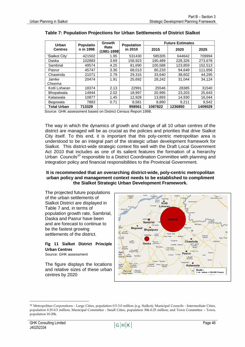
Urban Planning in Sialkot Part B – Section 3
Strategic Development Planning Framework
GHK Consulting Limited J40252334
Page 46
Table 7: Population Projections for Urban Settlements of District Sialkot
Urban Centres
Population in 1998
Growth Rate
(1981-1998)
Population in 2010
Future Estimates
2015 2020 2025
‗Sialkot City‘ 421502 1.95 531430 585305 644642 709994
Daska 102883 3.69 158,923 190,489 228,326 273,678
Sambrial 49574 4.25 81,690 100,588 123,859 152,513
Pasrur 45747 3.36 68,013 80,233 94,649 111,656
Chawinda 21071 2.79 29,315 33,640 38,602 44,295
Jamke Cheema
20474 1.91 25,692 28,242 31,044 34,124
Kotli Loharan 18374 2.13 22991 25546 28385 31540
Bhopalwala 14944 2.02 18,997 20,995 23,203 25,643
Kalaswala 10877 1.45 12,928 13,893 14,930 16,044
Begowala 7883 0.71 8,581 8,890 9,211 9,542
Total Urban 713329 958561 1087822 1236850 1409029
Source: GHK assessment based on District Census Report 1998.
The way in which the dynamics of growth and change of all 10 urban centres of the district are managed will be as crucial as the policies and priorities that drive Sialkot City itself. To this end, it is important that this poly-centric metropolitan area is understood to be an integral part of the strategic urban development framework for Sialkot. This district-wide strategic context fits well with the Draft Local Government Act 2010 that includes as one of its salient features the formation of a hierarchy Urban Councils10 responsible to a District Coordination Committee with planning and integration policy and financial responsibilities to the Provincial Government. It is recommended that an overarching district-wide, poly-centric metropolitan urban policy and management context needs to be established to compliment
the Sialkot Strategic Urban Development Framework.
The projected future populations of the urban settlements of Sialkot District are displayed in Table 7 and, in terms of population growth rate, Sambrial, Daska and Pasrur have been and are forecast to continue to be the fastest growing settlements of the district.
Fig 11 Sialkot District Principle Urban Centres
Source: GHK assessment The figure displays the locations and relative sizes of these urban centres by 2020
10 Metropolitan Corporations - Large Cities, population 0.5-3.0 million (e.g. Sialkot); Municipal Councils - Intermediate Cities, population 0.25-0.5 million; Municipal Committee - Small Cities, population 30k-0.25 million; and Town Committee – Town, population 10-20k.

Urban Planning in Sialkot Part B – Section 3
Strategic Development Planning Framework
GHK Consulting Limited J40252334
Page 47
The Sialkot Planning Area and Sialkot City
At the fulcrum of this overarching district-wide strategic development context, will be the development strategy for Sialkot urban area itself. It is foreseen that in the future Sialkot will increase its primacy in the district. In 2010 it is estimated that Sialkot accounts for a 66% share of the district‘s urban population. By 2020 it is forecast that this share will increase to over 76%. It is proposed that the new definition of ‗Sialkot Planning Area‘ should be adopted that implies a complex of urban settlements including not only the traditional Sialkot urban core city11 but also the Cantonment area, the rapidly growing adjacent urban areas that surround the ‗core city‘ and the outlying peripheral urban settlements and the interstitial rural areas that are likely to become contiguous through urban accretion growth during the planning period.
It is also recommended that a sub-set of the Sialkot Planning Area definition should be ‘Sialkot City’ consisting of the combined urban areas of the ‘core city, cantonment and the immediately adjacent ‘peri-urban’ areas that in 2010 were estimated to account for almost 42% of the total urban population (Table 7, line 7 ).
Sialkot is no more confined to core area limits. Because of limited land for in-fill development, congestion and higher densities in the city, there has been a substantial spill-over of population in areas outside the core area limits.
The Sialkot Planning Area includes the peripheral outlaying urban settlements that may not presently be contiguous but, under unbridled market force conditions, will become so within the next 20 years. This means that the boundaries of the Planning Area will need redefining at regular intervals to ensure that the ‘urban envelope’ circumscribes a land area that is adequate to meet future growth needs for the planning period under consideration. Ideally, this regular up-dating of what constitutes the Planning Area should coincide with a review and up-dating of the Sialkot Strategic Development Plan (SSDP) – say, on a 5 yearly basis. The importance of defining the Planning Area is that it aims to determine the planned limits to urban growth of Sialkot City within a specific timeframe. The degree to which development conforms to these limits will be a measure of success of the plans intent been implemented.
3.2.2 Population 2010 and Projections
Sialkot City and Planning Area 2010 Populations.
Three methods were used to estimate the 2010 population for Sialkot City and the Planning Area. For each method the following components were components:
Core City;
Cantonment;
Peri-urban urbanised areas; and
Peri-urban rural areas for the Planning Area.
11 The term has been used to identify the area under the jurisdiction of former Municipal Committee. Since MCs are no more there, the Consultants used the term ‘core city’ as a surrogate for the ex-MC area.
Sialkot City

Urban Planning in Sialkot Part B – Section 3
Strategic Development Planning Framework
GHK Consulting Limited J40252334
Page 48
The three methodologies used to establish the 2010 population for Sialkot City and the Planning Area were: 1. Projecting the 1998 population of the Core City (Ex MC area) and Cantonment
forward at the 1981-1998 growth rate, taken from the Census, plus applying an estimated average population density of 59 persons per acre12 was applied to the immediately adjacent peri-urban areas13.
2. The census map of Patwar circles was superimposed on a map of the built-up area. The 1998 population of each Patwar circle was then estimated as the proportion of the area within the 2010 built-up area boundary, multiplied by the 1998 population of the circle.
3. A hybrid of methods 1 and 2: the total census populations in 1981 and 1998 of the combined areas were projected to 2010. This was then broken down into functionally urban and rural populations, using the estimates of urban population described above and estimating the rural population based upon known trends in that sector.
The results of all three approaches were convergent and indicated the following:
The population of the Planning Area is about 0.912 million, growing at about 2.66% per annum;
The urban population (Sialkot City) of the Planning Area is about 0.550 million, growing at about 1.95% per annum; and
The rural population of the Planning Area is about 0.362million, growing at about 1.9% per annum.
Furthermore, the derived urban population growth rates were:
Core City: 1.95% (Source: Population Census Report, 1998)
Cantonment: 2.16% (Source: Population Census Report, 1998)
Adjacent per-urban built-up area: 8.6% at present incrementally slowing to 3.8% by 2040.
In summary, the population of the proposed Planning Area is about 0.912 million; of which 0.550million are urban and 0.362 million rural. The population of the area is growing at about 2.66 percent per annum, meaning that its population in 2020 will be approaching 1.25 million persons and in 2030 about 1.52 million. Within the Planning Area, the 2010 urban population is estimated to be 0.809 million of which Sialkot City urban area is estimated at about 0.550 persons and the peri-urban rural population nearly 0.276million. The populations of Sialkot District and Sialkot Tehsil have been growing at rates substantially above the national rate of about 1.9%. Sialkot District has grown from 1981 to 1998 at 2.46% per annum, while Sialkot Tehsil has grown at a higher rate of 2.64% per annum. This implies that there has been substantial migration into the District and Tehsil, and most of the latter can be assumed to have gone into Sialkot City.
12 The average density of Sialkot Core City plus the Cantonment. 13 The peri-urban built-up area was mapped using Google Earth and an average population density applied.
The areas determined were: Core City and Cantonment , 4,363 and 4,751 acres respectively and the peri-urban built-up area urbanised during the period 1998-2010 was estimated to be 6,479 acres with significant scope for further infilling.

Urban Planning in Sialkot Part B – Section 3
Strategic Development Planning Framework
GHK Consulting Limited J40252334
Page 49
Population Projections
Based upon 1981-1998 Census trends and more recent information on birth and death rates, the rate of natural increase for all of Pakistan is about 1.9%, and slowing. The same census data indicates that the average rate of urban population growth across cities of all sizes is 3.4%, about 70% above the rate of natural increase and about double the national rate of rural population growth of about 1.7%. An examination was made of the population growth rates of the largest cities in the country (Karachi, Lahore, Multan, Rawalpindi, Peshawar, Gujranwala and Faisalabad and it was found that these are also growing at about 3.4%. Hence the intermediate cities are also growing at an average rate of about 3.4%.
Table 8: Population of Sialkot District, Tehsil and Urban Area 1972-2010
Area 1972 1981 1998 2010
1. Sialkot District 1,509,424* 1,802,505 2,723,481 3,435000
% Growth to year 1.99% 2.46% 2.46%
2. Sialkot Tehsil 645,971 802,537 1,250,999 1,588000
% Growth to year 2.59% 2.64% 2.64
3. Sialkot Core Area 183,685 258,147 358,376 471428
% Growth to year 3.85% 1.95% 1.95%
4. Sialkot Cantonment 19,965 43,862 63,126 78990
% Growth to year 9.10% 2.16% 2.16%
5. Core Area + Cantonment 203,650 302,009 421,502 550418
% Growth to year 4.47% 1.98% 1.98%
6. Peri-Urban Areas (Urban) 286214 362135
% Growth to year 4.47% 1.98% 1.98%
7. Sialkot City (5+6) 707716 912,553
% of District Total Pop 22.3% 25.03%
% Growth to year 3.42%
8. Sialkot Planning Area ** 608,378 726090 1,332,246
% of District 34% 35% 37%
% Growth to year 2.7% 2.78%
** Approximately 913,000 urban and 49,693 rural Source: GHK assessment based on District Census Report 1998.
The rapid population growth rate of Pakistan‘s urban areas is occurring as a result of industrialization. Employment is growing more rapidly in manufacturing, finance, services, construction and trade than in agriculture, and this in turn is driving the growth of Pakistan‘s urban areas. Pakistan‘s urban population amounts to about half of the national total, indicating that Pakistan is in the middle of the urban population growth curve which may cover a period of 50-100 years. It may, therefore, be expected that the growth of Pakistan‘s cities will continue to be rapid for at least the next 25 years. It may be expected that the rate of natural increase will continue to slow as incomes increase, but even if this occurs the increasing rate of growth of per capita income will ensure that rapid urban population growth continues. The economies of Sialkot District and Sialkot Tehsil comprise both agricultural and non-agricultural activities, and it can be expected that both are growing somewhat above the national growth rate. However, of the two, the non-agricultural activities will be growing much more rapidly. Sialkot city is the home of the second-largest industrial complex in Pakistan. Its main industries, sporting goods, leather goods and surgical instruments, are all in high-demand sectors and have excellent potential for growth as both export industries and for home markets. The city is large enough to offer substantial business services but small enough to enable costs to be kept low. The city is close to the border with India and this is usually thought of as a liability. On the other hand, however, if peace prevails and the border is opened, the city would be well-positioned for even more rapid growth.
Urban Planning in Sialkot Part B – Section 3
Strategic Development Planning Framework
GHK Consulting Limited J40252334
Page 50
Having established the base population for 2010, and growth rates by city core, cantonment, peri-urban and rural components, the population of Sialkot Planning Area and the urban population of Sialkot City were projected using these baseline parameters on an exponential basis.
Table 9: Population Projections for Sialkot Planning Area
Population
Year Urban Rural Total % Urban
1981 352,009 256,370 608,379 0.58
1998 608,139 350,190 958,329 0.63
2010 912,553 419,693 1,332,246 0.68
2020 1110243 462,498 1572741 0.70
2030 1350801 486,150 1836951 0.74
Source: GHK assessment based on District Census Report 1998.
Table 10: Urban Population Projection for Sialkot City
City Area Population in Year
2010 2015 2020 2025 2030
Core Area 471428 519220 571857 629831 693681
Sialkot Cantt
78990 87898 97809 108839 121113
Peri-urban
362135 399434 440576 485955 536007
Total 912553 1006552 1110242 1224625 1350801
Source: GHK assessment based on District Census Report 1998.
During the next 20 years it is forecast that the economy of Sialkot will continue to grow, and to provide employment for a rapidly growing population, as employment in manufacturing, finance, trade, services and construction continues to grow.
As a result of continued growth of employment and in-migration of persons seeking jobs the population of Sialkot will grow at a rate of 3.2-3.4% per annum. The urban population of Sialkot City is expected to roughly double by 2030, to 1.35 million, and to reach 2.0 million by 2040, 20 years after project completion.
3.2.4 Urban Land Requirements – Projected Built-up Areas
The already existing pattern of industrial estate and housing society planning approvals will together with the growing income of the inhabitants be the key drivers of the future growth of the city. Based upon the population projections, and assuming a per capita real income growth rate of 2% per annum, it is projected that the area of the city will roughly triple over the next 20 years. This would comprise: 100% growth for the population effect, and 50% growth on 200% for the income effect. To examine the land requirements of the city from a different standpoint, the densities in existing built-up areas will continue to increase, but at a slowing rate. In parallel, the densities in semi-urban and peri-urban areas will be kept low as households with increasing incomes seek to buy land and construct houses on it. If, for example, the gross density of newly developing areas over the next 20 years is likely to be 59 persons per acre, the same density as the existing semi-urban areas. On this basis, it is projected that it would result in a 55% increase on the present urbanized area of15,600 acres, with the majority occurring in peri-urban development areas (see Table 11).

Urban Planning in Sialkot Part B – Section 3
Strategic Development Planning Framework
GHK Consulting Limited J40252334
Page 51
Table 11: Projected Land Area Requirements
Area Population (2030) Density (ppa) Land Area (acres)
Core City 693681 159 4,363
Cantonment 121113 26 4,751
Peri-Urban 536007 28 19,204
Total 1266582 48 28,318
Source: GHK assessment
Thus, even if the existing densities are maintained, the area of the city will double. However, it is more likely that over the next 20 years that average densities will decrease, in which case the area of the city could triple . On the following page Figure 12 displays the projected built-up area of Sialkot City under forecasted growth trends and reduced density assumptions
Figure 6: Projected Builtup Area
Urban Planning in Sialkot Part B – Section 3
Strategic Development Planning Framework
GHK Consulting Limited J40252334
Page 52
3.2.5 Proposed Planning Area - City Administrative Area
On the assumption that densities will decrease, as the city grows and expands during the next 20 years, it will triple in size, with most of the expansion occurring to the West and Southwest. Urban development will extend along Gujranwala Road to Daska, and along Wazirabad Road to Sambrial. Other major growth corridors will include to the Northwest, toward Kotli Loharan, and to the South, toward Pasrur. The contiguous urban area will cross the Tehsil Sialkot boundary between Daska and Sialkot and Sambrial and Sialkot. A metropolitan area will be emerging, which will encompass several urban areas. The continuing rapid spatial growth of the city will make it virtually impossible to encompass all the area of the city within the current administrative boundary of the city. Therefore, for purpose of effective city administration, it is recommended that the administrative boundary of the city be re-designated covering the area shown in Figure 13. As stated earlier ( ref: 3.2.1 Overarching District-wide Strategic Context) it is it is a fundamental pre-requisite to redefine the ‗Planning Area‘ concept within the context of a more overarching strategic approach to urban planning and growth management that takes account of the likely spatial form of Sialkot City over the next 20 years. Therefore, it is recommended that the new ‗Sialkot Planning Area‘ definition should be set within an overarching district-wide context that relates more to a poly-centric metropolitan concept of development. The Punjab Land Use Rules (2009) make provision for this – Ref Chapter III, article 36:
“Preparation of a district planning map – A City District Government or a District
Government shall prepare a district planning map by combining the notified planning maps of the Towns or Tehsils of the district”
This provision is also reflected in the Draft Punjab Local Government Act 2010 which features an administrative structure proposal to establish both Metropolitan and Municipal Corporations responsible at all levels of local government for municipal and devolved functions. In turn, through a District Coordinating Committee, headed District Coordination Officer (DCO), will have well-defined roles for integrating policy and planning coordination at the Provincial Government level.
If both of these statutes are implemented this should ensure that a legislative and institutional framework is in place to ensure alignment of all levels of local government in matters concerned with strategic plan preparation

Urban Planning in Sialkot Part B – Section 3
Strategic Development Planning Framework
GHK Consulting Limited J40252334
Page 53
Figure 7: Proposed Planning Area
Source: GHK assessment, Sialkot base map adopted from Urban Unit.
VEG
ETAB
LE
M
ARKET
TALWARA
KOTLI
JAURIAN KALAN
UGGOKI
MOOMAN KALAN
MIANI
HUNDAL
GURHI
SYEDANWALI
PIRANGPUR
FATEH
ADALAT
BHAGWAL
MUZAFARPURGOHADPUR
BOUNKAN
PINDI
RASOOL
LANGRIALI
DALLOWALI
BHARATH
BALLAWALA
PLAURA KALAN
KAMMANWALA
KHAROTA SYEDAN
KOTLI LOHARAN
MOONGAR
PINDI KHOKHAR
SHEEHNI
CHAPRAR
HED MARALA
GONDAL
HABIBPURA
MODEL
WORKS
SHAHABPURA
G U
J R
A
T
J A
M M
U &
PLANNINGBOUNDARY
MUGHLAN
ARAIYAN
PUR
BEHRAM
WATER
AWAN
GARH
GARH
(2030)
PLANNINGBOUNDARY(2020)
EXISTINGBUILT-UP AREA(2010)
TOWN
WATERWORKS
MUHAMMADPURA
NIKKAPURA
PURAHIRAN
AHMADPURAIMAM
SAHIB
SHAHSAYYADAN
SHAHABPURA HAJI
PURA
MUZAFFARPURA
MIANAPURA KARIM
PURA
DOBURJIARRAIYAN
CANTONMENT AREA
CHARIND
SIALKOTAIRPORT
LEGEND:
CORE BOUNDARY
EXISTING BUILT-UPAREA 2010
PROPOSED PLANNINGBOUNDARY 2020
PROPOSED PLANNINGBOUNDARY 2030
FIGURE:10 PROPOSED PLANNING AREA
TEHSIL BOUNDARY
K A
S H
M I
R
Urban Planning in Sialkot Part B – Section 3
Strategic Development Planning Framework
GHK Consulting Limited J40252334
Page 54
2.6. The Strategic Planning Framework - Managing Growth and Change.
The strategic planning framework aims to synthesis the knowledge from the retrospective insights gained from the existing situation and urban analysis. This established the baseline 2010 city and city region profile as the platform to understand the development forces at work, the problems and potentials emerging from the continuation of current trends. The Strategic Planning Framework must now present a foresight on what futures are possible, likely and desirable as a long-term development ‗Vision‘. How to achieve the Vision is then explored through a range of development scenarios that would seek to shift development onto a trajectory that will arrive at the long-term vision. The preferred development scenario is then elaborated to planned interventions could bring about the change that will achieve the desired development ‗Vision‘ for Sialkot‘s future.
3.3.1 Development Vision
The vision for the city is as follows:
Sialkot is more productive, efficient and competitive as a result of the improved effectiveness of urban planning and management reforms and interventions that results in a better utilisation of land, improved movement of goods and the overall improvement in the performance of the urban economy;
Sialkot citizens are satisfied with affordability and quality of urban service delivery, the continually improving quality of the urban environment and lifestyle for all sectors of society including vulnerable groups
Increased corporatisation of urban services and the overall participation in the private sector in the urban economy creates a sound and sustainable business environment that makes Sialkot one of Pakistan‘s most attractive cities for inward private sector investment.
Under Vision 202014, cities in Punjab should
be efficient and well-managed urban places;
be governed through effective institutional arrangements, development policy and strategic planning, and enhanced implementation and monitoring;
have well-managed, professionally-staffed utilities that provide a cost-effective, quality service for consumers;
have sound fiscal and financial management supported by successful public and private sector partnerships;
have proper regulatory and oversight arrangements; and where necessary
benefit from measurable, targeted and sustainable subsidies.
14
Punjab Provincial Government, Punjab‘s Vision 2020 Pre-Budget Policy Address of Chief Minister, Punjab, June 15, 2004

Urban Planning in Sialkot Part B – Section 3
Strategic Development Planning Framework
GHK Consulting Limited J40252334
Page 55
3.3.2 Future Development Scenarios
Sialkot has already established itself as a major industrial production centre and Pakistan‘s largest earner of foreign exchange. It is growing and urbanising rapidly and in doing so, changing its urban form. Industries, commercial and housing developments are radiating out along major transport corridors as more and more people use motorized transport. As stated earlier in this report, these new growth pattern trends are well underway and present both positive potentials and negative challenges. On the positive side, this ribbon-like, informal development brings onto the market land that is easily accessible and able to be developed at a relatively low cost. It takes advantage of the efficiencies offered by the new transport infrastructure. On the negative side, ribbon expansion increases travel and infrastructure servicing costs. As accretion development spreads laterally, extensive areas of unplanned urban sprawl are created. Unless these forces of development are positively harnessed, their consolidation will result in extensive radial development that will be increasingly difficult to regularize and service. Land uses in Sialkot City are mixed, and in many cases incompatible. Sialkot would benefit from stronger land use controls, to prevent potentially harmful activities from being located near residential areas and vice versa. There is a need for more open spaces, more space for industrial activities and a better-defined road network, in both core city and contiguous areas. Based upon the trends described above, the consultants have identified the following long term development options:
• Scenario 1. Continuation of Present Growth Pattern Trends:
Continued radial development, low priority for circumferential transport routes and unplanned per-urban accretion growth;
• Scenario 2. Modified Trend
Improved municipal planning and development control capacities together with urban management and reforms and improved municipal financial performance enables ribbon development along radial routes to be harnessed and in parallel, the incremental introduction of circumferential transport routes;
• Scenario 3. Cluster option:
higher priority for circumferential transport routes, combined with high priority for urban clusters separated by open spaces.
The advantages and disadvantages of each are briefly described below:
• Scenario 1.The continued radial development, low priority for circumferential transport routes (present trend continued) option would involve minimal investment levels, and minimal development controls (although improved over the present);
• Scenario 2. The continued radial development, high priority for circumferential transport routes would lead to a more efficient city, but involve higher levels of expenditure, particularly on road infrastructure; and
• Scenario 3. The continued radial development, high priority for circumferential transport routes with urban clusters separated by open spaces presents an interesting future possibility, but requires higher levels of expenditure, particularly
Urban Planning in Sialkot Part B – Section 3
Strategic Development Planning Framework
GHK Consulting Limited J40252334
Page 56
on road infrastructure, and significantly greater capacity to control development than is expected to exist even by the end of the project.
It is recommended, therefore, that the second and third options be considered during the more detailed planning to be undertaken under the project. The outcome of the two scenarios can be combined a as a hybrid future development ‗Vision‘ for Sailkot:
Vision – 2010 to 2030 – Sialkot Metropolitan Region
Short-term (2010-2015) – continued radial development + putting in place pre-conditions for incremental trend transformation and shift towards circumferential growth (Inner Ring Road corridor land use re-classification designation and land re-adjustment/acquisition). Medium-term (2015-2020) – circumferential growth priority through start of construction of Inner Ring Road and designation of Sialkot to Sambrial (Shab Pura+ Rail) ‗Mass Transit‘ Economic Development Corridor plus Outer Ring Road corridor land use re-classification designation and start of land re-adjustment/acquisition). Longer-term (2020-2030) - Radial growth pattern completely harnessed and under development control, existing Regional Park area expanded northwards between Upper Chanab Canal and Marala-Ravi Canal as the Sialkot Urban Parkway, Structure Plans for district urban cluster development + integrated public transit and utility delivery underpins the Sialkot Regional Metropolitan Strategy . The above sequential strategic ‗development ‗Vision‘ describes the transition from the radial – circumferential – decentralised concentration (i.e. a process of metropolitisation) in which the scenarios 1 and 2 are not mutually exclusive from one another but a continuum in a development process. A process of incremental transformation of current trends from radial to circumferential to the poly-centric metropolitan region and the achievement of the long-term ‗vision‘.

Urban Planning in Sialkot Part B – Section 3
Strategic Development Planning Framework
GHK Consulting Limited J40252334
Page 57
Figure 8: Proposed Outline Development Strategy Plan
Source: GHK assessment, Sialkot base map adopted from Urban Unit
VEG
ETAB
LE
M
ARKET
TALWARA
KOTLI
JAURIAN KALAN
UGGOKI
MOOMAN KALAN
MIANI
HUNDAL
GURHI
SYEDANWALI
PIRANGPUR
FATEH
HAJIPURAADALAT
BHAGWAL
MUZAFARPURGOHADPUR
BOUNKAN
PINDI
RASOOL
LANGRIALI
DALLOWALI
BHARATH
BALLAWALA
PLAURA KALAN
KAMMANWALA
SYEDAN
KOTLI LOHARAN
MOONGAR
PINDI KHOKHAR
SHEEHNI
CHAPRAR
HED MARALA
GONDAL
HABIBPURA
MODEL
SHAHABPURA
G U J R
A
T
SMALL INDUSTRIAL ESTATE
MUGHLAN
ARAIYAN
PUR
BEHRAM
AWAN
GARH
GARH
EXISTINGBUILT-UP AREA(2010)TOWN
WATERWORKS
MUHAMMADPURA
NIKKAPURA
PURAHIRAN
AHMADPURAIMAM
SAHIB
SHAHSAYYADAN
SHAHABPURA HAJI
PURAFATEHGARH
MUZAFFARPURA
MIANAPURA KARIM
PURA
DOBURJIARRAIYAN
CANTONMENT AREA
CHARIND
TO
HE
AD
MA
RA
LA
KALLU WAL ROAD
AB
IC R
OA
D
GHAZI ROAD
TO KALLU WAL
RO
AD
TO KAJLEY V
AL VIL
LAGE
CA
NT
T. R
OA
D
NULLAH AIKRANG PURA
TO BHAGO WALI
BHAGO WAL ROAD
TO KINGRAN
AIM
AN
AB
AD
RO
AD
TO WAZIR ABAD
RORAS ROAD
NULLAH AIK
TO FATEH
RORAS ROAD
DASKA R
OAD
TO D
ASKA
TO
AIM
AN
AB
AD
TO N
ARO
WAL
PA
SR
OO
R R
OA
D
RO
AD
DEFEN
CE
RA
ILW
AY
LIN
E
JAMMU ROAD
FAZAL ELHI
WAZIR ABAD ROAD
DEFEN
CE
RO
AD
HE
AD
MA
RA
LA
RO
AD
KASHMIR R
OAD
NULLAH
GOHADPUR R
OAD
SHAHAB PUR ROAD
ROAD
GARH
TO
NA
RO
WA
L
HE
AD
MA
RA
LA
KHAROTA
ROAD
TO
PIN
D S
IAD
PU
R
LEGEND:
COMMERCIAL
TANNERIES ESTATE
Figure 9: Proposed Outline Development Strategy Plan
ROADS
GROWTH DIRECTION
REGIONAL PARK
RESIDENTIAL
SIA
LKO
T
AIR
PO
RT
PROPOSED TANNERYINDUSTRIAL ZONE
REGIONALPARK
PROPOSEDLANDFILL SITE
AIRPORT R
OAD
Urban Planning in Sialkot Part B – Section 3
Strategic Development Planning Framework
GHK Consulting Limited J40252334
Page 58
Outline of Recommended Interventions
Based upon the experience to date, the policy initiatives underway and the anticipated capacity of the city planning agencies by the end of the project, it is proposed that the interventions used to influence and control the future growth of the city comprise, amongst others, the following:
Preparation of the Land Use Classification Plan as per the Punjab Land Use Rules15. To establish the baseline status quo in terms of land use at a particular point in time.
Using this Sialkot Strategic Development Plan (SSDP) Framework and Action Plan as a basis for the preparation of a complimentary Local Economic Development (LED) Strategy
Using the SSDP Framework and Action Plan plus the LED as a basis to prepare a comprehensive Sialkot Strategic Development Plan (SSDP alias Structure Plan) and within this the following sub-set of plans:
- A zoning plan protecting transport facility rights of way, industrial zones for potentially harmful or environmentally sensitive industrial activities, and spaces for other public facilities such as open spaces;
- Local area plans and zoning plans for declared road corridors and peri-urban areas, showing rights of way for roads and other public facilities, as well as the location of the industrial zones, commercial zones and other features of major importance, as described above.
- A land use reclassification scheme(s) and development scheme for two central city areas requiring urgent redevelopment (e.g. the central market area and the Jail Road area), these will act as ‗models‘ for replication elsewhere.,
A Transport Plan will be prepared under separate funding as an input to compliment the area wide SSDP and the Peri-urban Structure Plans;
Peri-urban Settlement Planning
Preparation of a ‗model‘ Local Economic Development (LED) Strategy for a Peri-urban settlement within the proposed Planning Area to provide the future strategic development ‗Vision‘ broken down into specific development goals, targets and related plans of action. This will act as a ‗model‘ development framework for the preparation of the Peri-urban Structure Plans and provide a basis for replication for the prepartion of additional LEDs and Structure Plans.
Within the LED framework prepare a ‗model‘ Structure Plan for a Peri-Urban Settlement Area and Declared Road Area Structure Plans and Redevelopment Schemes may be modified from time to time as necessary to ensure they reflect current trends and conditions in the areas covered;
15
Government of Punjab, Local Government and Community Development Department, notified Land Use Rules (2009)
Urban Planning in Sialkot Part B – Section 3
Strategic Development Planning Framework
GHK Consulting Limited J40252334
Page 59
Planning and Development Principles
Planning permissions extended to include not only the larger private housing schemes and industrial schemes, but all housing and industrial development projects for which building permits are required;
In case a planning permission is requested for an area for which the land is not classified, it will be considered on its merits as is currently being done;
Land use conversion permits will be extended to include not only commercial uses but also residential and industrial uses, as outlined in the Land Use Rules 2009;
Projects of central government, provincial government and local government agencies will be subject to the same planning review as projects of private parties; this will include infrastructure projects as well as building construction projects;
Ongoing land use classification and property mapping initiatives will be continued;
The staff of TO (P&C) will be increased from one Planner to one Planner and four Assistant Directors, to handle the increased planning workload;
A Planning Board or Planning Authority with substantial private sector representation will be created to make and enforce major planning decisions;
Enforcement mechanisms will be strengthened. Amongst others, consideration must be given to whether road and other infrastructure rights of way will be protected through land acquisition, declaration of rights of way or other mechanisms such as declaration of protected zones.
The above proposed interventions constitute a basic planning system framework and are derived from lessons learned in preparing this document and the application of the Land Use Rules 2009.
The implementation of these strategic interventions would serve to guide and rationalize the growth of the city whilst incrementally harnessing and guiding market forces to deliver more optimal outcomes.
The adoption of the principles and interventions would enable the positive aspects of urban ‗market-led‘ growth to be harnessed and managed whilst militating against the negative social and environmental impacts, while in parallel delivering the outcomes desired by key stakeholders and citizens.

Urban Planning in Sialkot Part B – Section 3
Strategic Development Planning Framework
GHK Consulting Limited J40252334
Page 60
3.4 Component of the Strategic Development Planning Framework
Within the context of the overarching Strategic Development Framework (3.3) a number of plans will be prepared in accordance with the statutory lists included under the Punjab Land Use Rules (2009) e.g. "master plan" means a land use plan of an area and includes a Structure plan, an outline development plan, a spatial plan, peri-urban structure plan and a metropolitan plan. The following outline descriptions of the SSDP component plans serves as a ‗primer‘ for the future preparation of the plans under the next tranche of PCIIP funding.
3.4.1 Overall Transport System Planning
The circulation system of Sialkot consists of a number of inter-city radial routes and the ring road connecting Pasrur Road with Wazirabad Road. Many radial routes converge at points within or close to the central business district (CBD) contributing to traffic delays and congestion. One of the main objectives of the strategic planning framework is to increase capacity of existing roads and junctions, opening up new development areas, traffic management in the existing downtown area, and decentralization different activities in the city centre which attract/generate large volumes of traffic. The following proposals may be considered for improving the circulation pattern in Sialkot: A series of concentric roads around Sialkot are needed to discourage through traffic entering and leaving Sialkot for different destinations and to reduce travel times between the suburbs and the city. Over the past two decades the tremendous spatial expansion of Sialkot has been accompanied by a proportionate increase in vehicular traffic which has placed great stress on urban roads leading to frequent traffic jams and increased pollution. In order to alleviate the negative quality of life impacts that this growth has imposed, concentric roads around Sialkot are proposed. It is anticipated that these will decongest the traffic flow on the existing major arterials and together with the planned restructuring of the settlements pattern around the City, will improve the connectivity and performance of the city. More specifically, the proposed roads will:
• Relieve congestion in inner parts of Sialkot. • Provide orbital linkages to radial arterial roads such as Zafarwal Road, Pasrur
Road, Eminabad Road, Gujranwala Road, Wazirabad Road and Airport Road etc.
• Create options for development of better located and well-connected housing schemes/satellite townships
• Provides quick access to the airport, dry port, export promotion zone, the under consideration site for tanneries etc. from strategic parts of the city
• Connect various industrial nodes located along the radial roads.
It is foreseen that the proposed concentric roads may include:
• An inner concentric road to encompass the built-up area of Sialkot. • An intermediate road • An outer concentric road, roughly coinciding with the boundary of ‗area of
influence‘ of Sialkot.

Urban Planning in Sialkot Part B – Section 3
Strategic Development Planning Framework
GHK Consulting Limited J40252334
Page 61
A schematic diagram of the proposed road system is in Figure 15. As the city grows, public transportation will become more and more important. A plan for development of public transportation should be prepared in near future, possibly following the preparation of the transport master plan. The Transport and Traffic Management Sector Action Plan preparatory activities under Tranche 1 of the PCIIP financing package is based on the following
Improve the functionality of current road network where major traffic circulation takes place through low cost improvements in junction layouts, signaling equipment, rationalizing road space usage equitably for pedestrians, NMT and public transport for increasing access to the transport system of the urban poor.
.
Improve road safety situation on road network with application of standard road signage and markings.
Improve the working of the Bus Station through improved layout for its organized working, space allocation to various terminal activities that shall ensure safety and comfort of the passengers and convenience of movement of buses.
Having carried out the preliminary organizational analysis we suggest to carry out further work and analysis before making recommendations for organizational improvements. However, for the execution of the first tranche of the program, institutional capacity building for TMA and office of the Sialkot Cantonment Executive Officer, responsible for Bus Terminal Building and road sections/ junctions falling under their jurisdiction will be a priority.
3.4.2 Urban Corridor16 Planning
Developing major road corridors are affected by rapid uncontrolled industrial, housing and commercial growth, much of it occurring in an uncontrolled and unplanned fashion, and without adequate infrastructure. Industrialists are adept at finding low-cost locations, and even with the best of intentions and information it is often difficult to predict these. With respect to road corridor plans and peri-urban plans, a road network hierarchy should be developed and applied to the plans, and to the extent possible a complete road network should be identified. If, however, it proves impossible (due to lack of information) to designate a complete road network, or if the road network cannot be confirmed due to land acquisition or other difficulties, then the intersection points on major roads should be identified and these and the normal rights of way of the roads should be protected through non-issuance of conversion permits.
16
Punjab Land Use Rules (2009) "industrial corridor‖ means a road or segment of a road, with not less than sixty feet right of way and has been reclassified as such by a competent authority

Urban Planning in Sialkot Part B – Section 3
Strategic Development Planning Framework
GHK Consulting Limited J40252334
Page 62
Figure 9: Road Network Planning
Source: Sialkot base map adopted from Urban Unit.
VEGETABLE
MARKET
TALWARA
KOTLI
JAURIAN KALAN
UGGOKI
MOOMAN KALAN
MIANI
HUNDAL
GURHI
SYEDANWALI
PIRANGPUR
FATEH
HAJIPURAADALAT
BHAGWAL
MUZAFARPURGOHADPUR
BOUNKAN
PINDI
RASOOL
LANGRIALI
DALLOWALI
BHARATH
BALLAWALA
PLAURA KALAN
KAMMANWALA
SYEDAN
KOTLI LOHARAN
MOONGAR
PINDI KHOKHAR
SHEEHNI
CHAPRAR
HED MARALA
GONDAL
HABIBPURA
MODEL
SHAHABPURA
G U J R
A
T
PROJECTEDBUILT-UP AREA
SMALL INDUSTRIAL ESTATE
MUGHLAN
ARAIYAN
PUR
BEHRAM
AWAN
GARH
GARH
(2030)
PROJECTEDBUILT-UP AREA(2020)
EXISTINGBUILT-UP AREA(2010)
TOWN
WATERWORKS
MUHAMMADPURA
NIKKAPURA
PURAHIRAN
AHMADPURAIMAM
SAHIB
SHAHSAYYADAN
SHAHABPURA HAJI
PURAFATEHGARH
MUZAFFARPURA
MIANAPURA KARIM
PURA
DOBURJIARRAIYAN
CANTONMENT AREA
CHARIND
SIALKOTAIRPORT
TO
HE
AD
MA
RA
LA
KALLU WAL ROAD
AB
IC R
OA
D
GHAZI ROAD
TO KALLU WAL
RO
AD
TO KAJLEY V
AL VILLAGE
CA
NT
T.
RO
AD
NULLAH AIKRANG PURA
TO BHAGO WALI
BHAGO WAL ROAD
TO KINGRAN
AIM
AN
AB
AD
RO
AD
TO WAZIR ABAD
RORAS ROAD
NULLAH AIK
TO FATEH
RORAS ROAD
DASKA R
OAD
TO D
ASKA
TO
AIM
AN
AB
AD
TO N
ARO
WAL
PA
SR
OO
R R
OA
D
RO
AD
DEFEN
CE
RA
ILW
AY
LIN
E
JAMMU ROAD
FAZA L E LHI
WAZIR ABAD ROAD
DE
FE
NC
E R
OA
D
HE
AD
MA
RA
LA
RO
AD
K AS HMIR R
OAD
NULLAH
GO
HAD
PUR RO
AD
SHAHAB PUR ROAD
ROAD
GARH
TO
NA
RO
WA
L
HE
AD
MA
RA
LA
KHAROTA
ROAD
TO
PIN
D S
IAD
PU
R
LEGEND:
CORE BOUNDARY
PROPOSED PLANNING
Figure:11 Planning Road Network
PRIMARY ROADS
SECONDARY ROADS
ROADS

Urban Planning in Sialkot Part B – Section 3
Strategic Development Planning Framework
GHK Consulting Limited J40252334
Page 63
3.4.3 Per-urban17 Planning – Short term Action Plan Measures.
Some of the newly urbanized areas adjacent to Sialkot City, due to organic/unplanned growth, do not have satisfactory street networks. It will be important ahead of the preparation of the proposed Peri-urban Structure Plans to prepare Action Plans to guide and control development with a view to ensuring that development does not further encroach on route corridors and thereby further jeopardising or pre-empting the possibility to make provision for proper circulation without recourse to costly land acquisition measures. A schematic diagram of a typical peri-urban area is displayed in Figure 12 while a schematic diagram of a peri-urban areas in which development is guided according to a simple structure plan are illustrated in Figure 16.
Figure 10 : A Typical Peri-Urban Area – Before Planning Interventions
Source: adopted from google
Punjab Land Use Rules: Land use in peri-urban areas.- A City District Government or a Tehsil Municipal Administration shall ensure that land use in a peri-urban areas are in accordance with the peri-urban area structure plan. As an integral part of peri-urban planning, it is recommended that a component should be the preparation structure plans for the proposed ‗cluster‘ areas that are featured as a key strategic concept of the recommended strategic development
17 Punjab Land Use Rules: A City District Government or a Tehsil Municipal Administration shall ensure that
the area that spans the landscape between contiguous urban development and rural countryside with low population density and is predominantly been used for agricultural activity and is likely to be urbanised in the next 20 years, is notified as a peri-urban area.

Urban Planning in Sialkot Part B – Section 3
Strategic Development Planning Framework
GHK Consulting Limited J40252334
Page 64
framework. Prior to undertaking the structure planning of the ‗cluster‘ areas it is recommended that a Local Economic (LED) Development Strategy is prepared that fully engages the private sector in the process of its preparation. Why is Local Economic Development (LED)important? With greater international multi-donor initiatives and developing country governments' emphasis on poverty reduction (Millennium Development Goals) and decentralization in recent years, there is increased responsibility being placed on municipal and/or local government to develop strategies to increase jobs and revitalise local and regional economies. The main aim of local economic development (LED) initiatives is to encourage local participation and consensus building to determine economic and social welfare initiatives for the locality and the community. The concept of local economic development is based on promoting local approaches that respond to local needs and conditions
lf the built-up area of two or more adjoining Tehsils is contiguous, the District Coordination Officer may constitute a joint committee of the Tehsil Municipal Administrations to prepare a consolidated peri-urban structure plan18.
Figure 11: A Typical Peri-Urban Area – After Planning Interventions
Source: adopted from google
18
Ref: Punjab Land Use Rules: rule 23 (4).
New Road
New Housing
Park
School Public Building
Local Road Primary Road
Legend:

Urban Planning in Sialkot Part B – Section 3
Strategic Development Planning Framework
GHK Consulting Limited J40252334
Page 65
3.4.4 Commercial19 and Industrial20 Development Consolidation21 Planning
Policies for the consolidation of industries should be carried out in a manner to ensure:
activities are only permitted to locate areas land use zoned for industry and preferably in a planned industrial estates;
environmental management agreements are applied as part of the development permit provisions with the aim of incentivising best practice environmental procedures.
Complementarity of activities with the aim of optimising economic cluster economic benefits.
Acknowledging that it is important to consolidate industrial development, it must also be recognized that the majority of new industrial and commercial development sites will occur spontaneously, without prior planning intervention. This being the case, a three-pronged approach is proposed to planning review of industrial sites:
Sites should be designated for potentially harmful industrial areas and potentially harmful industries should be required to locate in them.
When an application is made for industrial use of an area classified for residential or agricultural use, the case should be considered on its merits without prejudice simply for reason that the land is not classified industrial; if necessary, and if no harm results, a land use reclassification should be processed; this would not be allowable under the Rules as presently written; and
If upon consideration of an application for industrial development in an area classified for residential or agricultural use it is decided to allow the proposed industrial development, consideration should be given immediately thereafter to creation of an industrial zone in the area around the proposed development.
Although in the past consolidated industrial development areas have not been accomplished, another effort should be made at establishing such areas, commencing perhaps with the area around the Airport and on Gujranwala and Pasrur Roads. The Chamber of Commerce has already established an industrial zone there, and the consultants have proposed construction of a solid waste disposal site. The area could be developed as a mixed use area, and location for potential harmful or environmentally problematic industries. Discussions should be held with the Chamber of Commerce to determine how long the existing industrial zones can be expected to be adequate, and to identify any additional zones that may be necessary.
19 Ref: Punjab Land Use Rules – Section 8 permitted and permissible uses 20 Ref: Punjab Land Use Rules – Section 9 permitted and permissible uses 21 Punjab Land Use Rule (2009): A City District Government or a Tehsil Municipal Administration shall incorporate land use classification for an approved scheme and established built-up area on the satellite
imagery of the area which shall be known as consolidated land u se classification map.
Urban Planning in Sialkot Part B – Section 3
Strategic Development Planning Framework
GHK Consulting Limited J40252334
Page 66
3.4.5 Redevelopment22 Planning
City Centre Identity
The quality of the built and non-built environment and the spaces between buildings create the urban townscape that gives character and identity to urban centres. These are a bi-product of the inter-action between private sector and public sector initiatives and transactions to invest, incentivise, guide and control development.
Punjab Land Use Rules (2009) Land use in notified area.- A City District Government or a Tehsil Municipal Administration shall ensure that the following land use provisions under permitted, permissible and prohibited uses are strictly followed in a notified area:
historically significant area:
a competent authority shall ensure that land use in a historically significant area is in accordance with any special or general law:
Redevelopment23
Two core city areas are recommended for immediate land use redevelopment: i. The old market area near the Fort, and ii. The underutilized area near Jail Road.
In the case of the former, some modest improvements in infrastructure and infrastructure management should yield very substantial improvements in the environment and liveability of the area. In the case of the latter, a golden opportunity exists to redevelop the area into a modern complex of institutional and commercial entities, through a redevelopment project funded by private investors.
3.4.6 Land Use Reclassification24 Planning
Most of the core city area consists of closely placed, conflicting land uses which could be considered for reclassification in the near future. Identifying and prioritizing an urban block or group of urban blocks proposed for reclassification in accordance with the following criteria:
trend of changes in the existing land uses;
market demand for the change of land use in the area; compatibility with adjoining uses;
potential for up-gradation of serving road network; and prospects for redevelopment.
Prior to the reclassification planning a City District Government or Tehsil Municipal Administration shall prepare land use reclassification scheme after the notification of consolidated land use classification map.
22
Punjab Land Use Rules (2009) "redevelopment" means renewal, reconstruction or up-gradation of infrastructure and buildings in an area; 23 Ref: Punjab Land Use Rules (2009) – Chapter V Redevelopment Plan. 24 Ref: Punjab Land Use Rules (2009) – Chapter IV Land Use Reclassification.

Urban Planning in Sialkot Part B – Section 3
Strategic Development Planning Framework
GHK Consulting Limited J40252334
Page 67
Demonstration Project – TMA Office
It is planned that a new TMA office building be constructed in a location more accessible to the public transportation than the present one. When this occurs, consideration could be given to redeveloping the Fort area as a park, historical monument or zoo. Park space is limited in Sialkot, and the space currently occupied by TMA and other offices would be ideal for one of the purposed listed.
The Draft Punjab Local Governance Framework 2010 proposes a re-invented Urban Governance Model which would mean specialized treatment of Urban Centres within the local government framework.
Open Space Sialkot presently, with the exception of a few areas such as ‗Gulshan-e-Iqbal‘ lacks open spaces. This deficiency could be remedied through the creation of public parks and open spaces in each peri-urban area, and a regional park possibly adjacent to the two canals to the west of the city. A major component of the proposed SSDP Framework is the creation of a Regional Park area expanded northwards between Upper Chanab Canal and Marala-Ravi Canal creating a ‗green cordon‘ defining the limits of urban growth in the north-eastern arc and within which the Sialkot Urban Parkway as a major recreational facility could be developed.
TA 7321 – PAK Punjab Cities Improvement
Investment Program
Government of Punjab Urban Unit
Part B
Section 4
ACTION PLAN - ROAD MAP AND DELIVERY STRATEGY
January 2011
(J40252334)
GHK Consulting Ltd.


Urban Planning in Sialkot Part B – Section 4
Action Plan - Road Map and Delivery Strategy
GHK Consulting Limited J40252334
Page 70
3.0 ACTION PLAN - ROAD MAP AND DELIVERY STRATEGY
3.1. Urban Planning Actions
The bulleted list below sets out what are considered to be the key tasks that will need to be undertaken in the strategic plan-making process to meet the statutory requirements as set out in the Punjab Land Use Rules (2009). Each topic will need elaborating as a detailed programme of work with related resource requirements when procuring professional services under PCIIP.
A Plan Map prepared and notified not later than July 1, 2011;
A Structure Plan that is fully integrated with transport and other urban sector
service delivery plans prepared and notified not later than July 1, 2014;
Public and private transportation networks clearly designated and rights-of-way
safeguarded;
Lands for industrial estates and open spaces designated and zones
safeguarded;;
Potentially harmful industries located in compliance with best environmental
management practice.
Commercial development subject to best practice planning guidelines and
development controls enforced;
Plans for selected peri-urban areas and road corridors prepared and notified;
Land use reclassification and redevelopment program for selected city areas
underway;
Planning processes understood and supported by the general public; and
Planning institutions in effective operation, with necessary arrangements for
enforcement of plan provisions;
Good governance achieved through public consultation, participation and
awareness measures.

Urban Planning in Sialkot Part B – Section 4
Action Plan - Road Map and Delivery Strategy
GHK Consulting Limited J40252334
Page 71
3.2. The Next 5 Years Table 12 sets out what are considered to be the priority activities at activate the strategic development process and an estimate of the related resource requirements.
Table 12: Priority Strategic Development Planning Activities – 2010-2015
Activity Prerequisite
activity Method
Information required
Coverage (%)
No. of cases per
year
Staff days per case
Staff days required
Cost (Rs 000 per
annum)
Notify public rights of way Rights of way identified in plans, confirmed on ground
Planning, field investigation, mapping, legal
Plan maps including existing land use and topography
Na Na 130 130 (one time activity, repeated every 10 years)
170 (once every 10 years)
Monitor land subdivision and building activities including encroachments on public right of way
Rights of way identified on plan maps
Google Earth, field investigation
Encroachments shown on plan maps
100 5500 .02 110 144
Remove encroachments on public right of way
Encroachments identified and scoped
Legal action, followup police action
Encroachments shown, legal proceedings concluded
100 275 initially, declining over time
1.0 550 720
Consider land use conversion application: agricultural to residential or industrial
Existing land use mapping done
Administrative action
Existing land use classification
25% 1100 .1 110 144
Consider land use conversion application: residential to commercial (primarily major road corridors)
Existing land use mapping done along major corridors
Administrative action
Existing land use classification
50% 500 .1 50 65
Identify unauthorized conversions, and take necessary action
Ground truth Planning and administrative action
Existing land use classification
25% of all residential and industrial conversions
1100, declining over time
0 200 262
Consider housing estate land development applications
Housing society prepares development application
Planning review
Site visit, plans, public discussion
5% initially, increasing over time
10 6 60 79

Urban Planning in Sialkot Part B – Section 4
Action Plan - Road Map and Delivery Strategy
GHK Consulting Limited J40252334
Page 72
Activity Prerequisite
activity Method
Information required
Coverage (%)
No. of cases per
year
Staff days per case
Staff days required
Cost (Rs 000 per
annum)
Consider industrial land development applications
Industrial society or owner prepares development application
Planning review
Site visit, plans, public notice
25% initially, increasing over time
5 8 40 52
Monitor housing estate and industrial developments
Na Google earth, field investigation
Location of new activities
100% 5500 .004 22 29
Identify unauthorized developments, and take necessary action
Planning and administrative action
Location of unauthorized developments
100% 5 schemes 4 20 26
Consider building applications
House owner prepares building application
Building review
Designs, site visit, public notice
10% initially, increasing over time
220 initially, increasing over time
2 440 576
Monitor building activities Google earth, field investigation
100% 0 0 26
Identify unauthorized building, and take necessary action
Planning and administrative action
Location of unauthorized building
tbd 0 0 0
Monitor all land use changes
Google earth, ground truth
Planning activity
Existing land use classification
50-100% of residential and industrial conversions
5500 0.05 110 144
Total 1712 2267
Source: GHK assessment

Urban Planning in Sialkot Part B – Section 4
Action Plan - Road Map and Delivery Strategy
GHK Consulting Limited J40252334
Page 73
3.3. Planning and Capacity Building Action Plan
Implementation of the city vision, and achievement of the outcomes described above, will require implementation of a planning and capacity building action program that will focus on and greatly expand planning activities and institutions. The main features of the action plan are summarized below.
Launch the Planning Process This involves obtaining the funding required, defining the planning to be done, and mobilizing the human resources required, all in a well-sequenced series of actions covering the next 8 years. It is expected that a structure plan plus would be prepared for Sialkot, together with structure plans for selected peri-urban areas and road corridors. In addition, a redevelopment effort might be launched in the central city area. All of these need to be thought out in as much detail as possible before they are implemented, in order that the actual outcomes are consistent with the expectations of the program.
Creating the Institutional Framework
Under the Land Use Rules 2009, an institutional framework is to be created at the District level comprising a Plan Scrutiny Committee and an Industrial Scrutiny Committee. A district planning and design committee is to be constituted chaired by the District Commissioner with 13 members comprising city officials, representatives of provincial and federal government agencies, town planners and architects and representatives of the association of builders and developers and civil society. This is to be accompanied by an Industrial Area Scrutiny Committee. The two committees are responsible for scrutiny of the maps and plans prepared by the municipality. Although there is provision for private sector participation in both of these, both of them are basically dominated by government. It is proposed, therefore, that a bridge be built to the private sector by creating a City Planning Board, that would independently review the work of the TMA, and rule on major decisions reached by them, including on the structure plan plus and the structure plans for peri-urban areas and road corridors. The City Planning Board would therefore constitute a higher authority. It would comprise five representatives of the private sector, two representing the community at large, two representing the Chamber of Commerce and Industry, and one representing NGOs, with the Chairman being chosen by closed ballot amongst the five representatives. If a stronger institutional arrangement is desired, a planning authority could be established. Such an authority would have a governing Board with composition similar to that proposed above, It would have its own staff and sources of revenue, and be able to enforce conformance with land use reclassifications, land use conversion permits, building permits and other, similar activities. Regardless of whether a Planning Board or a Planning Authority is established, consideration could be given to contracting out plan enforcement activities. In this way they could be carriedout in accordance with a policy framework and kept more free of political considerations. Three alternative institutional arrangements are presented in Table 13, on the following page.
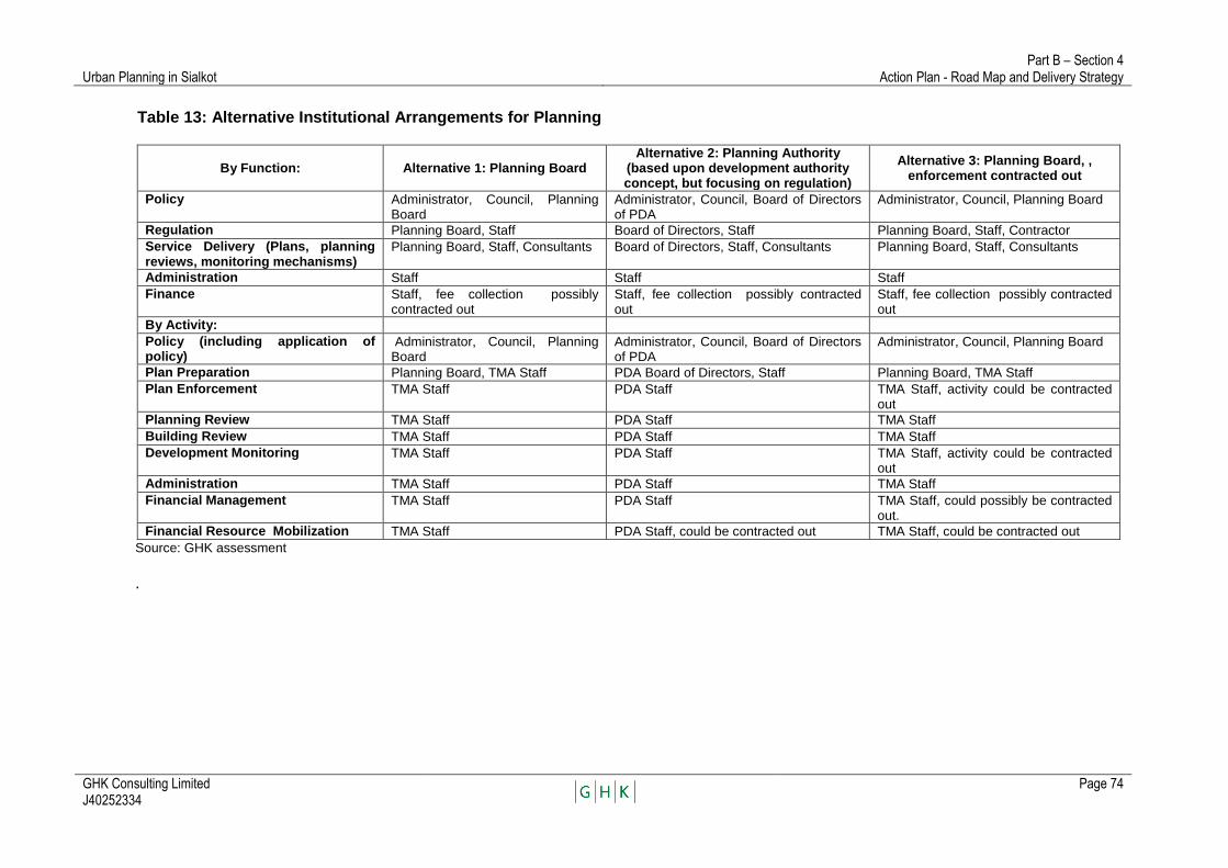
Urban Planning in Sialkot Part B – Section 4
Action Plan - Road Map and Delivery Strategy
GHK Consulting Limited J40252334
Page 74
Table 13: Alternative Institutional Arrangements for Planning
By Function: Alternative 1: Planning Board Alternative 2: Planning Authority
(based upon development authority concept, but focusing on regulation)
Alternative 3: Planning Board, , enforcement contracted out
Policy Administrator, Council, Planning Board
Administrator, Council, Board of Directors of PDA
Administrator, Council, Planning Board
Regulation Planning Board, Staff Board of Directors, Staff Planning Board, Staff, Contractor
Service Delivery (Plans, planning reviews, monitoring mechanisms)
Planning Board, Staff, Consultants Board of Directors, Staff, Consultants Planning Board, Staff, Consultants
Administration Staff Staff Staff
Finance Staff, fee collection possibly contracted out
Staff, fee collection possibly contracted out
Staff, fee collection possibly contracted out
By Activity:
Policy (including application of policy)
Administrator, Council, Planning Board
Administrator, Council, Board of Directors of PDA
Administrator, Council, Planning Board
Plan Preparation Planning Board, TMA Staff PDA Board of Directors, Staff Planning Board, TMA Staff
Plan Enforcement TMA Staff PDA Staff TMA Staff, activity could be contracted out
Planning Review TMA Staff PDA Staff TMA Staff
Building Review TMA Staff PDA Staff TMA Staff
Development Monitoring TMA Staff PDA Staff TMA Staff, activity could be contracted out
Administration TMA Staff PDA Staff TMA Staff
Financial Management TMA Staff PDA Staff TMA Staff, could possibly be contracted out.
Financial Resource Mobilization TMA Staff PDA Staff, could be contracted out TMA Staff, could be contracted out
Source: GHK assessment
.
Urban Planning in Sialkot Part B – Section 4
Action Plan - Road Map and Delivery Strategy
GHK Consulting Limited J40252334
Page 75
Once an institutional framework has been established, it will be necessary to create a consultation process with the public for each of the plans to be produced. Such a consultation process should be prepared before beginning implementation of any planning, and it should be detailed, time-bound and fully budgeted.
Create Plans
Preparation of the plans proposed, comprising an area wide structure plan plus, peri-urban and road corridor structure plans and a redevelopment plan, will be done primarily by consultants, closely and fully supported by staff of the TMA. Essentially the staff of the TMA will serve as the secretariat of the various planning exercises, while the Planning Board/Authority and Plan Scrutiny Committees will guide the work
Strengthen Plan Implementation Mechanisms Implementation of the plans prepared will require that planning reviews be extended to cover land development and building activities more fully, and at earlier stages of the development process. Consideration should be given to how, and where, such extensions will be made, necessary legislation prepared at an early date and a toolkit of planning procedures created to guide planning reviews.
The Land Use Rules provide for conversion of land from agricultural, residential and other uses into higher uses, with associated conversion fees. A continuous effort should be made to link together the planning review process with the requirements of the Rules for reporting on land use conversions.
Strengthen Property Taxation
Property taxation can be an important source of revenue for the TMA, and close linkages between property taxation and the planning system can help improve the former. It is suggested that efforts be made to modernize property taxation in the Sialkot area, through creation of a land cadastre, and that this be done as the planning system is strengthened.
Create Land Use Information Systems
Efforts are underway to improve land use mapping and to create land use information systems focused on Punjab‘s cities. This may begin with development of a land ownership cadastre and Include information on land use, utilities, topography, water and other resources. In the case of Sialkot a detailed land use classification has been prepared for the core city area. It should be extended to outlying areas and other parts of the information system developed as well.
Provide Capacity Building Support
Continuous efforts must be made to build capacity for planning—amongst the members of the Planning Board, the City Council, TMA staff and others involved in the planning process. To this end, a program of action is proposed comprising
Urban Planning in Sialkot Part B – Section 4
Action Plan - Road Map and Delivery Strategy
GHK Consulting Limited J40252334
Page 76
provision of (i) training and training instruments which might include familiarization with planning issues and procedures; implementation of the Land Use Rules 2009; manuals and guidelines; monitoring mechanisms and procedures; creation of computerized databases; use of GIS systems; planning record keeping and other, similar activities; (ii) learning from experience through visits to the planning offices of other cities in the region; and professional training for selected staff of planning offices of project cities in countries such as the United States, UK, Europe and Asia.
Increase Plan Preparation and Enforcement Activities There is no capacity to plan at present, and little capacity to review proposed land use changes. Over the next five years, it is proposed to prepare a structure plan for the city, and local area plans for selected peri-urban areas, central city areas and transport corridors. Issuance of land use conversion permits, processing of industrial development and housing development permits, processing of building permits and monitoring of compliance with plans and regulations are all to be enhanced. To accomplish this intensive work program and buildup of capacity, it is proposed that the planning staff of the TMA be enhanced by the addition of four planning officers and three building inspectors. In addition, it will be necessary to reframe and reissue various planning regulations. Perhaps one of the most important lines of action will be to consider how rights of way for public infrastructure, particularly roads, can be more effectively protected. The activities required to effectively implement the proposed strategic planning framework as described above and documenting the need for the additional staff proposed are described in detail in Appendix 9.
Budget The proposed subprojects to be financed under PCIIP Tranche 1 of the proposed loan project are set out in Table 14. It is proposed that plan maps, structure plans, peri-urban area plans, road corridor plans, reclassification schemes and redevelopment schemes be prepared in Sialkot and three other cities, with the first two structure plans being done with the assistance of international consultants and subsequent plans being done by domestic consultants. In addition, provision is made for the proposed capacity building program, willingness to pay surveys, provision of equipment and preparatory activities. The total proposed budget for PCIIP Tranche 1 is $4.2 million.

Urban Planning in Sialkot Part B – Section 4
Action Plan - Road Map and Delivery Strategy
GHK Consulting Limited J40252334
Page 77
Table 14: Proposed Loan Project
Subproject Ref
Description Base Cost
a
($ million) Responsibility
UU UU
Consultant
Project-specific
Contractor
SWCS/ Management Contractor
TMA
A Urban Sector and Municipal financial management
A-1 Provision of inputs for planning including aerial imagery, land use, topography and infrastructure systems mapping Sialkot and other cities
0.200 0.200 0 0
A-2 Preparation of plan maps and structure plans with major transport planning component for Sialkot and other cities
1.900 0 0 1.900
A-3 Preparation of peri-urban area plans and road corridor plans for Sialkot and other cities
.200 0 0 0.200
A-4 Preparation of central area reclassification plans and redevelopment plans for Sialkot and other cities
.175 0 0 0.175
A-5 Capacity building in urban planning and management: degree programs, exposure visits, system development and training
1.189 0 .1045 1.0755
A-6 WTP Surveys for 6 cities .240 0 0 .240
A-7 Provision of equipment for urban planning .300 .300 0 0
Total 4.204 0.5 0.1045 3.5905
Source: GHK assessment

TA 7321 – PAK Punjab Cities Improvement
Investment Program
Government of Punjab Urban Unit
Section 5
IMPLEMENTATION
January 2011
(J40252334)
GHK Consulting Ltd.

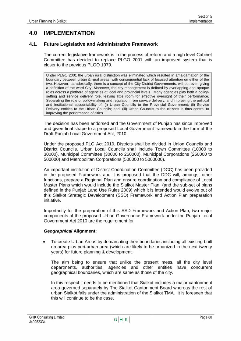
Urban Planning in Sialkot Section 5
Implementation
GHK Consulting Limited J40252334
Page 80
4.0 IMPLEMENTATION
4.1. Future Legislative and Administrative Framework
The current legislative framework is in the process of reform and a high level Cabinet Committee has decided to replace PLGO 2001 with an improved system that is closer to the previous PLGO 1979. Under PLGO 2001 the urban rural distinction was eliminated which resulted in amalgamation of the boundary between urban & rural areas, with consequential lack of focused attention on either of the two. However, paradoxically, there is a concept of the City District Governments, without even giving a definition of the word City. Moreover, the city management is defined by overlapping and opaque roles across a plethora of agencies at local and provincial levels. Many agencies play both a policy-setting and service delivery role, leaving little room for effective oversight of their performance. Separating the role of policy-making and regulation from service delivery, and improving the political and institutional accountability of: (i) Urban Councils to the Provincial Government; (ii) Service Delivery entities to the Urban Councils; and, (iii) Urban Councils to the citizens is thus central to improving the performance of cities.
The decision has been endorsed and the Government of Punjab has since improved and given final shape to a proposed Local Government framework in the form of the Draft Punjab Local Government Act, 2010.
Under the proposed PLG Act 2010, Districts shall be divided in Union Councils and District Councils. Urban Local Councils shall include Town Committee (10000 to 30000), Municipal Committee (30000 to 250000), Municipal Corporations (250000 to 500000) and Metropolitan Corporations (500000 to 5000000).
An important institution of District Coordination Committee (DCC) has been provided in the proposed Framework and it is proposed that the DDC will, amongst other functions, prepare a Regional Plan and ensure coordination and compliance of Local Master Plans which would include the Sialkot Master Plan (and the sub-set of plans defined in the Punjab Land Use Rules 2009) which it is intended would evolve out of this Sialkot Strategic Development (SSD) Framework and Action Plan preparation initiative.
Importantly for the preparation of this SSD Framework and Action Plan, two major components of the proposed Urban Governance Framework under the Punjab Local Government Act 2010 are the requirement for
Geographical Alignment:
To create Urban Areas by demarcating their boundaries including all existing built up area plus peri-urban area (which are likely to be urbanized in the next twenty years) for future planning & development.
The aim being to ensure that unlike the present mess, all the city level departments, authorities, agencies and other entities have concurrent geographical boundaries, which are same as those of the city.
In this respect it needs to be mentioned that Sialkot includes a major cantonment
area governed separately by The Sialkot Cantonment Board whereas the rest of urban Sialkot falls under the administration of the Sialkot TMA. It is foreseen that this will continue to be the case.
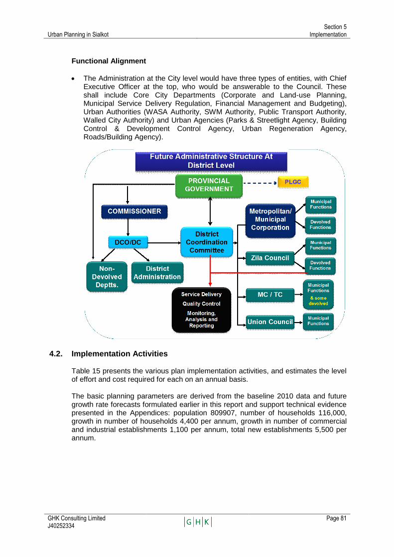
Urban Planning in Sialkot Section 5
Implementation
GHK Consulting Limited J40252334
Page 81
Functional Alignment
The Administration at the City level would have three types of entities, with Chief Executive Officer at the top, who would be answerable to the Council. These shall include Core City Departments (Corporate and Land-use Planning, Municipal Service Delivery Regulation, Financial Management and Budgeting), Urban Authorities (WASA Authority, SWM Authority, Public Transport Authority, Walled City Authority) and Urban Agencies (Parks & Streetlight Agency, Building Control & Development Control Agency, Urban Regeneration Agency, Roads/Building Agency).
4.2. Implementation Activities
Table 15 presents the various plan implementation activities, and estimates the level of effort and cost required for each on an annual basis. The basic planning parameters are derived from the baseline 2010 data and future growth rate forecasts formulated earlier in this report and support technical evidence presented in the Appendices: population 809907, number of households 116,000, growth in number of households 4,400 per annum, growth in number of commercial and industrial establishments 1,100 per annum, total new establishments 5,500 per annum.
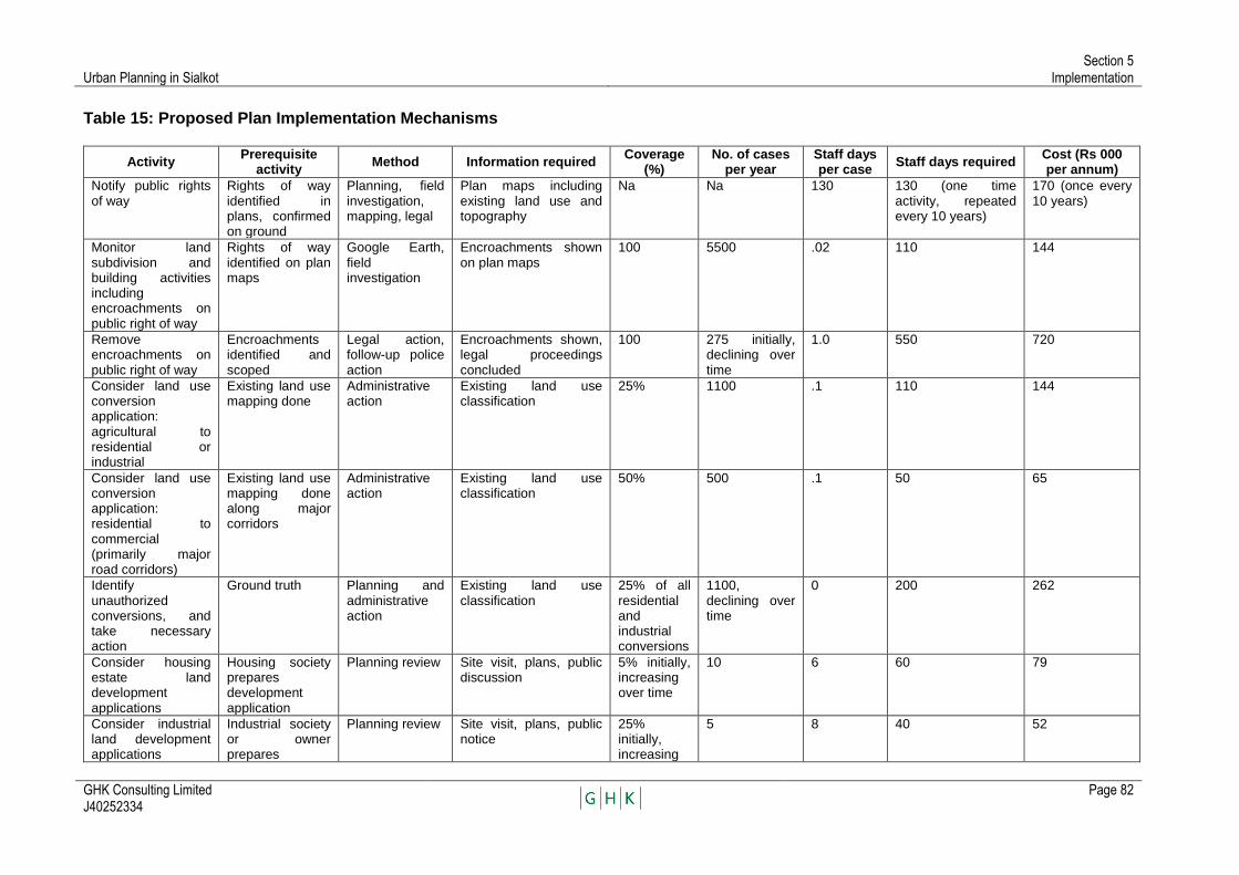
Urban Planning in Sialkot Section 5
Implementation
GHK Consulting Limited J40252334
Page 82
Table 15: Proposed Plan Implementation Mechanisms
Activity Prerequisite
activity Method Information required
Coverage (%)
No. of cases per year
Staff days per case
Staff days required Cost (Rs 000 per annum)
Notify public rights of way
Rights of way identified in plans, confirmed on ground
Planning, field investigation, mapping, legal
Plan maps including existing land use and topography
Na Na 130 130 (one time activity, repeated every 10 years)
170 (once every 10 years)
Monitor land subdivision and building activities including encroachments on public right of way
Rights of way identified on plan maps
Google Earth, field investigation
Encroachments shown on plan maps
100 5500 .02 110 144
Remove encroachments on public right of way
Encroachments identified and scoped
Legal action, follow-up police action
Encroachments shown, legal proceedings concluded
100 275 initially, declining over time
1.0 550 720
Consider land use conversion application: agricultural to residential or industrial
Existing land use mapping done
Administrative action
Existing land use classification
25% 1100 .1 110 144
Consider land use conversion application: residential to commercial (primarily major road corridors)
Existing land use mapping done along major corridors
Administrative action
Existing land use classification
50% 500 .1 50 65
Identify unauthorized conversions, and take necessary action
Ground truth Planning and administrative action
Existing land use classification
25% of all residential and industrial conversions
1100, declining over time
0 200 262
Consider housing estate land development applications
Housing society prepares development application
Planning review Site visit, plans, public discussion
5% initially, increasing over time
10 6 60 79
Consider industrial land development applications
Industrial society or owner prepares
Planning review Site visit, plans, public notice
25% initially, increasing
5 8 40 52

Urban Planning in Sialkot Section 5
Implementation
GHK Consulting Limited J40252334
Page 83
Activity Prerequisite
activity Method Information required
Coverage (%)
No. of cases per year
Staff days per case
Staff days required Cost (Rs 000 per annum)
development application
over time
Monitor housing estate and industrial developments
Na Google earth, field investigation
Location of new activities
100% 5500 .004 22 29
Identify unauthorized developments, and take necessary action
Planning and administrative action
Location of unauthorized developments
100% 5 schemes 4 20 26
Consider building applications
House owner prepares building application
Building review Designs, site visit, public notice
10% initially, increasing over time
220 initially, increasing over time
2 440 576
Monitor building activities
Google earth, field investigation
100% 0 0 26
Identify unauthorized building, and take necessary action
Planning and administrative action
Location of unauthorized building
0 0 0
Monitor all land use changes
Google earth, ground truth
Planning activity Existing land use classification
50-100% of residential and industrial conversions
5500 0.05 110 144
Total 1712 2267
Source: Plan proposed by PPTA team.

Urban Planning in Sialkot Section 5
Implementation
GHK Consulting Limited J40252334
Page 84
4.3. Service Delivery
The Draft Punjab Local Governance Framework 2010 proposes to strengthen local service delivery systems and operations though performance bench-marking and standard setting thus shifting from an input to an output-based regime. Also an important institution in the form of a District Coordination Committee (DCC) is provided for in the proposed Framework to perform the important function of enforcing service delivery regulations and putting in place an institutional framework for ensuring adherence to minimum service delivery standards for municipal services, as well as health and education. At a practical level this requires re-iterating the role of the Provincial Government as a policy-maker and financier of urban management, rather than a provider of individual services, with a clear mechanism of accountability for service delivery. Urban Councils require an expanded span of authority over service delivery and governance activities, but with also a clearly-defined arms-length relationship with service provision agencies.
5.3.1 Prioritization of projects by key urban service sectors
The key sectors are water supply, sewerage and drainage, solid waste management, transport and traffic management and the information presented is extracted from each of the Sector Strategy and Action Plans prepared by the consultants under the ADB PPTA PCIIP.
A. Water Supply, Sewerage and Drainage
Table 16: Priority Projects 2010-18 - PCIIP Tranche 1 Projects and Base Costs
Item no,
Description Estimated base cost ($ million)
Sialkot Water Supply
1 Rehabilitation of 99 existing tubewells, including provision of bulk water meter and pressure gauge, provision of new control panel including MCU unit, replacement of unsafe wiring, reinstatement/ repair of shaft lubrication arrangements, provision of chlorination equipment and repairs to the fabric of the pump-house as necessary. (This includes tubewells recently provided by PHED, some of which have yet to be commissioned but excludes 15 shallow tubewells to be replaced)
0.66
2 Replacement/deepening of 15 shallow or poorly performing tubewells 0.75
3 Distribution system changes to subdivide existing central distribution system into 3 – 4 zones, including purchase of portable flow meters, new interconnecting mains to allow transfers between zones during emergencies and new sluice valve (normally closed)
0.06
4 Water supply improvements in 3 zones, designed to improve pressures and reduce leakage, including installation of new PE water mains, removal/plugging of existing water mains and connections, provision of new PE connections (Replacing existing GI connections), installation of water meters and rehabilitation of existing elevated service reservoirs.
5.78
5 Measures to operationalize recently implemented PHED scheme in Gohadpur Road area, including provision of house connections, fitted with water meters, any necessary repairs to existing water mains, provision of bulk meters on tubewells, provision of MCU units as necessary.
1.12
6 New water supply scheme to serve three zones outside pre 2001 Municipal Boundary, including area west of Defence Road and north of railway, including areas on either side of Wazirabad Road (To be designed to incorporate existing TWs at mohallas Mumtaz Pura and Muzaffar Pura,
6.41
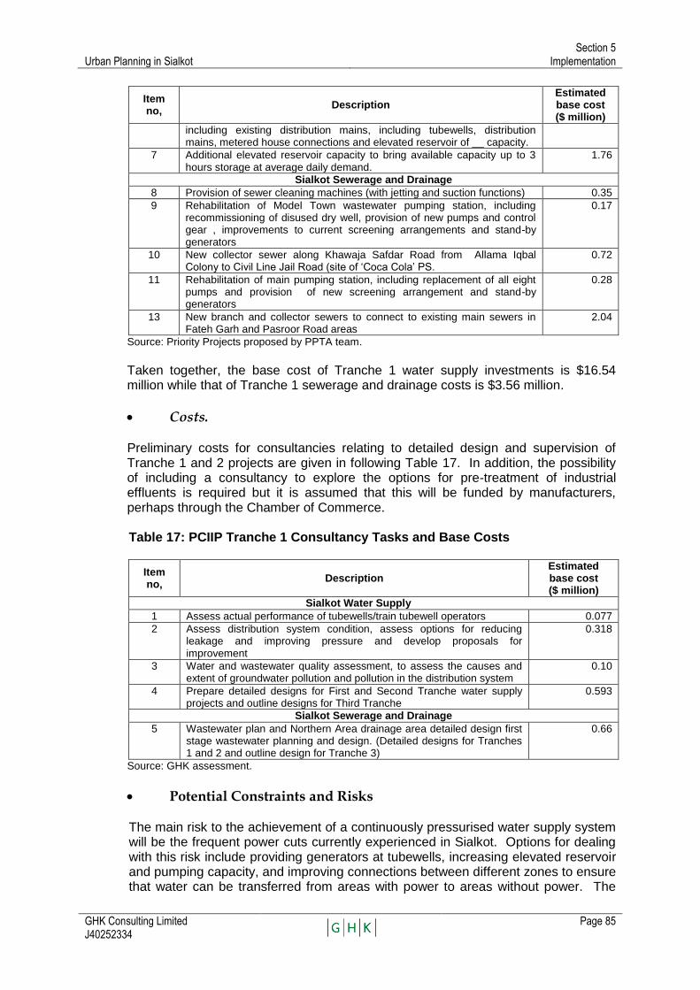
Urban Planning in Sialkot Section 5
Implementation
GHK Consulting Limited J40252334
Page 85
Item no,
Description Estimated base cost ($ million)
including existing distribution mains, including tubewells, distribution mains, metered house connections and elevated reservoir of __ capacity.
7 Additional elevated reservoir capacity to bring available capacity up to 3 hours storage at average daily demand.
1.76
Sialkot Sewerage and Drainage
8 Provision of sewer cleaning machines (with jetting and suction functions) 0.35
9 Rehabilitation of Model Town wastewater pumping station, including recommissioning of disused dry well, provision of new pumps and control gear , improvements to current screening arrangements and stand-by generators
0.17
10 New collector sewer along Khawaja Safdar Road from Allama Iqbal Colony to Civil Line Jail Road (site of ‗Coca Cola‘ PS.
0.72
11 Rehabilitation of main pumping station, including replacement of all eight pumps and provision of new screening arrangement and stand-by generators
0.28
13 New branch and collector sewers to connect to existing main sewers in Fateh Garh and Pasroor Road areas
2.04
Source: Priority Projects proposed by PPTA team.
Taken together, the base cost of Tranche 1 water supply investments is $16.54 million while that of Tranche 1 sewerage and drainage costs is $3.56 million.
Costs.
Preliminary costs for consultancies relating to detailed design and supervision of Tranche 1 and 2 projects are given in following Table 17. In addition, the possibility of including a consultancy to explore the options for pre-treatment of industrial effluents is required but it is assumed that this will be funded by manufacturers, perhaps through the Chamber of Commerce.
Table 17: PCIIP Tranche 1 Consultancy Tasks and Base Costs
Item no,
Description Estimated base cost ($ million)
Sialkot Water Supply
1 Assess actual performance of tubewells/train tubewell operators 0.077
2 Assess distribution system condition, assess options for reducing leakage and improving pressure and develop proposals for improvement
0.318
3 Water and wastewater quality assessment, to assess the causes and extent of groundwater pollution and pollution in the distribution system
0.10
4 Prepare detailed designs for First and Second Tranche water supply projects and outline designs for Third Tranche
0.593
Sialkot Sewerage and Drainage
5 Wastewater plan and Northern Area drainage area detailed design first stage wastewater planning and design. (Detailed designs for Tranches 1 and 2 and outline design for Tranche 3)
0.66
Source: GHK assessment.
Potential Constraints and Risks
The main risk to the achievement of a continuously pressurised water supply system will be the frequent power cuts currently experienced in Sialkot. Options for dealing with this risk include providing generators at tubewells, increasing elevated reservoir and pumping capacity, and improving connections between different zones to ensure that water can be transferred from areas with power to areas without power. The
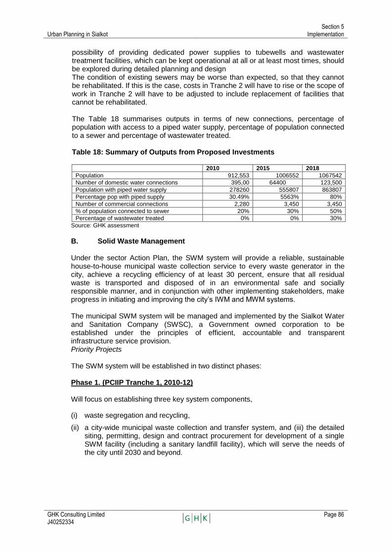
Urban Planning in Sialkot Section 5
Implementation
GHK Consulting Limited J40252334
Page 86
possibility of providing dedicated power supplies to tubewells and wastewater treatment facilities, which can be kept operational at all or at least most times, should be explored during detailed planning and design The condition of existing sewers may be worse than expected, so that they cannot be rehabilitated. If this is the case, costs in Tranche 2 will have to rise or the scope of work in Tranche 2 will have to be adjusted to include replacement of facilities that cannot be rehabilitated. The Table 18 summarises outputs in terms of new connections, percentage of population with access to a piped water supply, percentage of population connected to a sewer and percentage of wastewater treated.
Table 18: Summary of Outputs from Proposed Investments
2010 2015 2018
Population 912,553 1006552 1067542
Number of domestic water connections 395,00 64400 123,500
Population with piped water supply 278260 555807 863807
Percentage pop with piped supply 30.49% 5563% 80%
Number of commercial connections 2,280 3,450 3,450
% of population connected to sewer 20% 30% 50%
Percentage of wastewater treated 0% 0% 30%
Source: GHK assessment
B. Solid Waste Management
Under the sector Action Plan, the SWM system will provide a reliable, sustainable house-to-house municipal waste collection service to every waste generator in the city, achieve a recycling efficiency of at least 30 percent, ensure that all residual waste is transported and disposed of in an environmental safe and socially responsible manner, and in conjunction with other implementing stakeholders, make progress in initiating and improving the city‘s IWM and MWM systems. The municipal SWM system will be managed and implemented by the Sialkot Water and Sanitation Company (SWSC), a Government owned corporation to be established under the principles of efficient, accountable and transparent infrastructure service provision. Priority Projects The SWM system will be established in two distinct phases:
Phase 1. (PCIIP Tranche 1, 2010-12) Will focus on establishing three key system components,
(i) waste segregation and recycling,
(ii) a city-wide municipal waste collection and transfer system, and (iii) the detailed siting, permitting, design and contract procurement for development of a single SWM facility (including a sanitary landfill facility), which will serve the needs of the city until 2030 and beyond.

Urban Planning in Sialkot Section 5
Implementation
GHK Consulting Limited J40252334
Page 87
Phase 2(PCIIP Tranche 2, 2013-15)
Will include (i) construction and commissioning of the SWM facility, (ii) acceleration of waste segregation and recycling initiatives, and (iii) assisting industrial groups to develop and implement an IWM strategy and action plan25; and the Sialkot TMA to further evaluate Sialkot‘s MWM sector to develop an MWM strategy and action plan.
Costs Outline capital costs for Tranche 1 investments are estimated at US$ 4.364 million, and Tranche 2 investments are estimated at US$ 12.328 million. The SWM Department of the SWSC will be responsible to develop and operate the Sialkot SWM system. Solid Waste Action Plan
Tranche 1 (2010-12) Estimated Cost US$ 4.364 Million Duration 2010-12 Components Recycling System Support and Public Awareness
Program Waste Collection and Transfer System
Solid Waste Management Facility (Siting, Design and Procurement)
Tranche 2 (2013-15) Estimated Cost US$ 12.328 Million Duration 2013-15 Components Recycling System Support and Public Awareness
Program Solid Waste Management Facility (Construction and
Operation)
Strategy Development and Action Plan: Industrial and Medical Waste Management
C. Transport and Traffic Management
Action Plan
1. Road Infrastructure Urban transport management improvements relevant to road infrastructure usually referred as ‗Traffic Management Improvements‘ in Sialkot shall comprise of following sub-components;
i) Improvement of signalized crossings ii) Improvement of non-signalized crossings iii) Minor road side works iv) Road signage and markings Execution of the road related project components is aimed at improving the traffic conditions and circulation, passenger mobility and access to dominant land uses
25
The Chamber of Commerce has expressed interest to evaluate disposal options for the industrial wastes generated from their 5,400 member organizations. This will include surveys and analysis of all of Sialkot‘s industrial waste and development of an IWM strategy and action plan for future implementation by the private sector.

Urban Planning in Sialkot Section 5
Implementation
GHK Consulting Limited J40252334
Page 88
through improving the efficiency of 12 major road junctions, key sections of primary road network through implementation of traffic management schemes with emphasis on improving pedestrian facilities, road drainage and designated road space allocation for road side parking and relevant activities.
2. Improvement of Bus Terminal
New bus terminal with capacity to handle 2,000 bus departures and 120 thousand passenger transfers a day is intended to improve the passenger transfer activity, circulation and facility improvement of buses, passengers and local transit traffic. Construction of the bus terminal through performance based contract shall help share the risks through private sector participation.
3. Developing City Public Transport Services
Though not part of the financial package in the proposed first tranche of the program, it is recommended that priority should be given to organizing formal public transport (Bus) operations in the city and its suburbs including settlements within a radius of 15 to 20 km. The objective of initiating this component is to bring the informal operations under the umbrella of regulatory regime, provide support for making it more bus intensive and if need be include the sub-component for assistance through subsequent program tranche.
4. Organization Improvement Organizational improvements through establishing a local/ regional transport authority is a key program component intended to manage sector activities in a more professional manner. Further work is suggested on this issue; however, capacity building of TMA, Office of the Sialkot Cantonment Executive Officer and DRTA, DCO Office Sialkot would be required for smooth execution of this subcomponent. Additional engineering man power at managerial level is suggested in association with other project subcomponents. Intermittent and continuous specialists support is also suggested for these local organizations.
Costs
Table 19: PCCIP Tranche 1 Sub Project 2010-2012 Costs
Cost In USD (m)
1 Road crossings improvements 2.000
2 Road signage/markings 0.300
3 Minor road works 1.750
4 Bus Terminal 1.000
5 Signal Equipment 0.360
6 Sub: Total 5.410
7 Total cost (including consultancies (contingencies) 6.664.4
Source: GHK assessment

TA 7321 – PAK Punjab Cities Improvement
Investment Program
Government of Punjab Urban Unit
URBAN PLANNING IN
SIALKOT
APPENDICES
January 2011
(J40252334)
GHK Consulting Ltd.

Urban Planning in Sialkot Appendix A-1
Population Estimates and Forecasts
GHK Consulting Limited J40252334
Page 92
A.1 POPULATION ESTIMATES AND FORECASTS Methodology Population estimates and projections have been prepared for each of the 11 cities included in the Project. The methodology for these was as follows:
1) A review was made of relevant documents and information sources, including the 1981 and 1998 Censuses, the Vision 2030 document, various economic reports, and reports and studies of each of the cities in the project.
2) Maps were prepared identifying the present boundaries of the urban agglomeration, and these were overlaid on maps of administrative (Union Council) boundaries.
3) From these maps, and related 1998 Census data, the 1998 functional urban population of each city was determined, as described for Sialkot below.
4) A database was assembled for each city comprising the population of the District, the Tehsil, the pre-2001 city, the cantonment and the peri-urban area.
5) Analyses were prepared of the population growth trends for each administrative area, and
6) Projections were made of the population of each city, based upon national urban growth trends, the growth trend of the surrounding region and the economic base of the city.
Trends Analysis Based upon 1981-1998 Census trends and more recent information on birth and death rates, the rate of natural increase for all of Pakistan is about 2.0%, and slowing. The same census data indicates that the average rate of urban population growth across cities of all sizes is 3.4%, about 70% above the rate of natural increase and about double the rate of rural population growth of about 1.7%. An examination was made of the population growth rates of the largest cities in the country (Karachi, Lahore, Multan, Rawalpindi, Peshawar, Gujranwala and Faisalabad and it was found that these are also growing at about 3.4%. Hence the intermediate cities are also growing at an average rate of about 3.4%. The rapid population growth rate of Pakistan‘s urban areas is occurring as a result of industrialization. Employment is growing more rapidly in manufacturing, finance, services, construction and trade than in agriculture, and this in turn is driving the growth of Pakistan‘s urban areas. Pakistan‘s urban population amounts to about half of the national total, indicating that Pakistan is in the middle of the urban population growth curve which may cover a period of 50-100 years. It may, therefore, be expected that the growth of Pakistan‘s cities will continue to be rapid for at least the next 25 years. It may be expected that the rate of natural increase will continue to slow as incomes increase, but even if this occurs the increasing rate of growth of per capita income will ensure that rapid urban population growth continues. The population projections for the other PCIIP priority 11 cities had a population of 7.9 million persons, of which Sialkot had 912,500. By 2030, the population of the 11 cities will be 15 million, and by 2040 it will be 20.6 million. During the next 30 years the economy of Sialkot will continue to grow, and to provide employment for a rapidly growing population, as employment in manufacturing, finance,
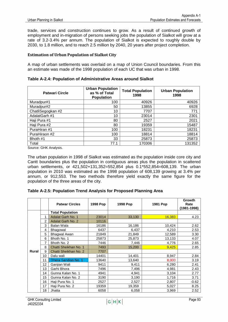
Urban Planning in Sialkot Appendix A-1
Population Estimates and Forecasts
GHK Consulting Limited J40252334
Page 93
trade, services and construction continues to grow. As a result of continued growth of employment and in-migration of persons seeking jobs the population of Sialkot will grow at a rate of 3.2-3.4% per annum. The population of Sialkot is expected to roughly double by 2030, to 1.8 million, and to reach 2.5 million by 2040, 20 years after project completion.
Estimation of Urban Population of Sialkot City A map of urban settlements was overlaid on a map of Union Council boundaries. From this an estimate was made of the 1998 population of each UC that was urban in 1998. Table A-2.4: Population of Administrative Areas around Sialkot
Patwari Circle Urban Population
as % of Total Population
Total Population 1998
Urban Population 1998
Muradpur#1 100 40926 40926
Muradpur#2 50 13855 6928
ChatliSegogkan #2 10 7707 771
AdalatGarh #1 10 23014 2301
Haji Pura #1 80 2527 2021
Haji Pura #2 80 19359 15487
PuraHiran #1 100 18231 18231
PuraHiraon #2 100 18814 18814
Bhoth #1 33 25873 25873
Total 77.1 170306 131352 Source: GHK Analysis.
The urban population in 1998 of Sialkot was estimated as the population inside core city and Cantt boundaries plus the population in contiguous areas plus the population in scattered urban settlements, or 421,502+131,352=552,854 plus 0.1*552,854=608,139. The urban population in 2010 was estimated as the 1998 population of 608,139 growing at 3.4% per annum, or 912,553. The two methods therefore yield exactly the same figure for the population of the three areas of the city. Table A-2.5: Population Trend Analysis for Proposed Planning Area
Patwar Circles 1998 Pop 1998 Pop 1981 Pop
Growth Rate
(1981-1998)
Rural
Total Population
1 Adalat Garh No. 1 23014 33,130 16,383 4.23
2 Adalat Garh No. 2 10116
3 Balan Wala 16186 16,186 10,424 2.62
4 Bhagowal 6437 6,437 4,210 2.53
5 Bhagwal Awan 21849 21,849 12,589 3.30
6 Bhoth No. 1 25873 25,873 13,133 4.07
7 Bhoth No. 2 7446 7,446 4,776 2.65
8 Chatti Sheikhan No. 1 7493 15,200 9,425 2.85
9 Chatti Sheikhan No. 2 7707
10 Dalu wali 14401 14,401 8,947 2.84
11 Dhera Sandian No. 1 13640 13,640 8,000 3.19
12 Ganjian Wali 9411 9,411 6,280 2.41
13 Garhi Bhora 7496 7,496 4,981 2.43
14 Gunna Kalan No. 1 4941 4,941 3,104 2.77
15 Gunna Kalan No. 2 3190 3,190 1,716 3.71
16 Haji Pura No. 1 2527 2,527 2,807 -0.62
17 Haji Pura No. 2 19359 19,359 5,027 8.25
18 Jhatta 6058 6,058 3,969 2.52

Urban Planning in Sialkot Appendix A-1
Population Estimates and Forecasts
GHK Consulting Limited J40252334
Page 94
Patwar Circles 1998 Pop 1998 Pop 1981 Pop
Growth Rate
(1981-1998)
19 Jhulki 17406 17,406 11,001 2.74
20 Jorian Kalan 11154 11,154 7,503 2.36
21 Kala Harawan 6886 6,886 4,472 2.57
22 Kandan Pur 6627 6,627 4,055 2.93
23 Kapuro wali 8915 8,915 5,553 2.82
24 Kotli Loharan 4414 4,414 2,968 2.36
25 Kaurowal 6899 6,899 1,926 7.79
26 Mainder Wal 4257 4,257 3,006 2.07
27 Malhu Chatt 15259 15,259 9,677 2.72
28 Markewal No. 1 13240 25,405 16,843 2.45
29 Markewal No. 2 12165
30 Mango Bahram 2463 2,463 1,766 1.98
31 Moman No. 1 8244 8,244 5,193 2.76
32 Moman No. 2 8219 8,219 5,145 2.79
33 Mandian Wala 12877 12,877 8,014 2.83
34 Murad Pur No. 1 40926 40,926 26,643 2.56
35 Murad Pur No. 2 13855 13,855
36 Ora No. 1 7121 15,965 11,071 2.18
37 Ora No. 2 8844
38 Pathan Wali 6390 6,390 4,080 2.67
39 Pucca Kotli 31105 31,105 17,597 3.41
40 Pura Hiran No. 1 18231 18,231 8,320 4.72
41 Pura Hiran No. 2 18814 18,814 10,540 3.47
42 Rasulpur 9063 9,063 6,137 2.32
43 Roras 4906 4,906 3,391 2.20
44 Ugoki 26921 26,921 12,731 4.50
45 Wandian Wala 4532 4,532 2,906 2.65
Total 536,877 306,309 3.36
Sialkot Core City 358,376 258,147 1.95
Sialkot Cantt 63,126 43,862 2.16
Sialkot Planning Area 958,379 608,318 2.71
Urban Population
Sialkot Core City 358,376 258,147 1.95
Sialkot Cantt 63,126 43,862 2.16
Peri-Urban Areas 186,687 50,000 8.06
Sialkot Urban Area 608,189 352,009 3.43
Rural Population 350,190 256,309 1.85
Data from Census
Estimated from land use data
Estimated from census data and land use data
Estimated as residuals
Estimated as sums
Source: GHK Analysis.

Urban Planning in Sialkot Appendix A-1
Population Estimates and Forecasts
GHK Consulting Limited J40252334
Page 95
Table A-2.5: Union Councils in Proposed Planning Areas:
Union Councils in Proposed Planning Area- close in Union Councils s in Proposed Planning Area-
further out
Union Council Population (2010)26
Union Council Population (2010)27
Bharat 38,693 Jaurian Kalan 37,646
Muzafarpur 37,646 Bhagwal Awan 37,646
Dhadpur 37,646 Uggoki 40,633
Baunkan 37,354 Moman Kalan 37,646
Adalat Garh 35,213 Pirangpur 37,646
Miani 37,646 Syed Wali 37,646
Charind 38,687 Rasulpur 37,646
Talwara Mughlan 27,719 Dallowali 37,646
Kotli Behram 37,646 Kamanwali 37,646
Doburj Arraiyan 37,646 Kharota Syedan 37,646
Nikapura 37,646 Ballawala 37,646
Total 403,542 Total 417,093
Grand Total 820,635
Source: GHK Analysis.
The present and projected population of the Planning Area is shown below. Table A-2.7: Population Projection for Sialkot Planning Area
Year Urban Rural Total % Urban Urban Rural Total
1981 352,009 256,370 608,379 0.58 na na na
1998 608,139 350,190 958,329 0.63 3.3 1.85 2.70
2010 912,553 419,693 1,332,246 0.68 3.43 1.5 2.78
2020 1110243 462,498 1572741 0.70 3.42 1 2.70
2030 1,350801 486,150 1836951 0.74 3.42 0.5 2.71
Source: GHK Analysis.
26 For those UCs whose populations is not readily available, average population (37,646) per UC has been put
in. 2727 The population given is of entire UC; parts of which could be urban, semi-urban or rural.
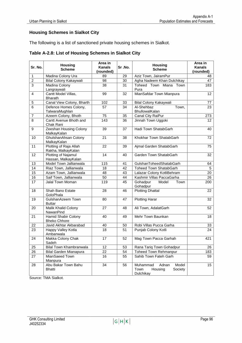
Urban Planning in Sialkot Appendix A-1
Population Estimates and Forecasts
GHK Consulting Limited J40252334
Page 96
Housing Schemes in Sialkot City The following is a list of sanctioned private housing schemes in Sialkot. Table A-2.8: List of Housing Schemes in Sialkot City
Sr. No. Housing Scheme
Area in Kanals
(rounded) Sr .No.
Housing Scheme
Area in Kanals
(rounded)
1 Madina Colony Ura 89 29 Aziz Town, JairamPur 48
2 Bilal Colony Kakaywali 98 30 Agha Nadeem Khan Dulchikay 47
3 Madina Colony Langraywali
38 31 Toheed Town Miana Town Pura
183
4 Cantt Model Villas, Bharath
99 32 MianSafdar Town Mianpura 12
5 Canal View Colony, Bharth 102 33 Bilal Colony Kakaywali 77
6 Defence Homes Colony, TalwaraMughlan
57 34 Al-Shehbaz Town, BhullowalKalan
23
7 Azeem Colony, Bhoth 75 35 Canal City RaiPur 273
8 Cantt Avenue Bhoth and Chak Rani
143 36 Jinnah Town Uggoki 12
9 Zeeshan Housing Colony MalkayKalan
39 37 Hadi Town ShatabGarh 40
10 GhulshanAhsan Colony MalkayKalan
21 38 Khokhar Town ShatabGarh 72
11 Plotting of Raja Allah Rakha, MalkayKalan
22 39 Ajmal Garden ShatabGarh 75
12 Plotting of Najamul Hassan, MalkayKalan
14 40 Garden Town ShatabGarh 32
13 Model Town Jallianwala 115 41 GulshanToheedShatabGarh 64
14 Riaz Town, Jallianwala 18 42 Toheed Town ShatabGarh 5
15 Azam Town, Jallianwala 48 43 Lalazar Colony KotliBehram 20
16 Saif Town, Jallianwala 50 44 Kashmir Villas PaccaGarha 26
17 Jalal Town Moman 119 45 Gohadpur Model Town Gohadpur
200
18 Shah Bano Estate GoloPhala
28 46 Plotting Dhattal 22
19 GulshanAzeem Town Buttar
80 47 Plotting Harar 32
20 Malik Khalid Colony NawanPind
27 48 Ali Town, AdalatGarh 52
21 Hamid Shabir Colony Bheko Chhore
40 49 Mehr Town Baunkan 18
22 Javid Akhtar Akbarabad 40 50 Robi Villas Pucca Garha 33
23 Happy Valley Kotla Ambanwala
18 51 Punjab Colony Kotli 24
24 Makka Colony Chak Sadeh
17 52 Mag Town Pacca Garhah 421
25 Bilal Town Khambranwala 12 53 Rana Tariq Town Gohadpur 26
26 Bilal Garden Mianapura 22 54 Toheed Town Rehmanpur 183
27 MianSaeed Town Mianpura
16 55 Sahib Town Fateh Garh 59
28 Abu Bakar Town Bahu Bhatti
34 56 Muhammad Adnan Model Town Housing Society Dulchikay
15
Source: TMA Sialkot.


GHK Consulting Limited Clerkenwell House, 67 Clerkenwell Road,
London, EC1R 5BL, United Kingdom Tel: +44 (0) 20 7611 1100 Fax: +44 (0) 20 7368 6960 E-mail: [email protected]
Internet: http://www.ghkint.com
GHK Consulting Limited House No 5, Officer Block,
Noor Pur Road, Muslim Town, Faisalabad, Pakistan
Tel. & Fax: +92 (0) 41 881 7644-45 E-mail: [email protected]
Internet: http://www.ghkpak.com