urban design - boulder, colorado · transit village area plan • boulder colorado 21 urban design...
TRANSCRIPT

Transit Village Area Plan • Boulder, Colorado 19
Urban Design
Chapter 3: Urban Design
The Urban Design Chapter consists of two parts: A. Character DistrictsB. Streetscapes.
A. Character DistrictsThe area has been divided into eight character districts, primarily based on futureland use. The guidelines that follow for each district are intended to promote plangoals related to urban design, public spaces and livability. They will be used by thecity to create new or revised standards for the area. They also will be used by theprivate sector to help understand how the plan vision applies to development.The guidelines will be considered in the Site Review process to ensure that newdevelopment will be compatible with the character established by this plan.
The future described for each character district will occur gradually, with the mostchange likely to occur first in the districts west of the railroad tracks and later, eastof the tracks.
The eight character districts within
the urban design framework for
the area include:
- Pearl Street Center
- Rail Plaza
- 30th Street Corridor
- Valmont Corridor
- Steelyards
- Old Pearl
- Pearl Parkway
- Wilderness Place
“Place-making is important.People will come to take atrain or a bus, and they willlike it while they are there.”
- Peter Albert, Director ofTransportation Planning,
San Francisco Municipal Railway,
May 2006 TVAP charrette
Character Districts
Inviting outdoor spaces of various sizes
and types will contribute to making the
area both livable and lively.

20 Transit Village Area Plan • Boulder, Colorado
Urban Design
General Guidelines
The following guidelines apply to all charac-
ter districts.
Building Placement and Design• Orient the main facade to the street and
provide an entrance on the street side ofthe building.
• Design buildings with pedestrian-scalematerials and architectural articulation,particularly on the first floor. Avoid largeblank walls. Along streets and sidewalksprovide pedestrian interest, includingtransparent windows and well-definedbuilding entrances.
• Consider opportunities to frame or pre-serve views of the Flatirons to the south-west.
Useable Open Space• Incorporate well-designed, functional open
spaces with tree, quality landscaping andart, access to sunlight and places to sitcomfortably. Where public parks or openspaces are not within close proximity, pro-vide shared open spaces for a variety ofactivities. Where close to parks, openspaces provided by development may besmaller.
Permeability• While the improved street network will
provide more frequent pedestrian connec-tions, also provide multiple opportunitiesto walk from the street into projects, thuspresenting a street face that is permeable.Also provide opportunities to walk withinthe interior between abutting properties.This is especially important where streetblocks are large, for example in theWilderness Place District.
Parking Structures• Design the ground level of a parking struc-
ture to be interesting and appealing forpedestrians, for example, by wrapping theground level with active uses, such asretail. Include pedestrian-scale façadearticulation, architectural detailing andquality materials.
• Where the ground level is open orexposed to interior drives, paths, or park-ing lots, screen it with a low wall and/orevergreen landscaping.
• If tuck-under parking or podium parking(half-level underground) is provided,locate it at the rear of the property orwrap with active uses if feasible.
• Where feasible, locate structureentries/exits on secondary, not primarystreets. Avoid locating entries/exits onmain pedestrian routes. Entries/exitsshould be carefully designed to ensuresafe, comfortable, and uninterruptedpedestrian flow on adjacent sidewalks.
Bus Stops• Include the following for bus stops adja-
cent to development projects: a shelter,benches, route and schedule signage.Additional enhancements are encouraged,such as pedestrian lighting, art, landscap-ing, and waste receptacles. Bike racksshould be provided at regional route stops.(Refer to the bus route and stop informa-tion on the Transit Map in the Appendix.See the Implementation Plan for fundinginformation.)
Junction Place• In addition to the street trees, sidewalks
and bike facilities specified by the JunctionPlace streetscape section, provide seating,planters, art, special pavement and lightingalong Junction Place. (See theImplementation Plan for information onfunding of the city share.)
• Where feasible, place active uses, such asretail or commercial services on the firstfloor of buildings along Junction Place.
• Provide way-finding features such as spe-cial pavements, signs, or art, to facilitatepedestrian movement between JunctionPlace,Rail Plaza, the rail platform andunder/overpass, the bus station, GooseCreek Greenway, Pearl, Valmont, 30thStreet and Wilderness Place. (See theImplementation Plan for funding informa-tion.)
Mixed-Use Buildings• The potential for conflicts between resi-
dential and non-residential uses withinmixed-use buildings should be minimizedthrough careful design and building systemplanning. Consider the compatibility ofspecific uses. Issues could include noise,vibration, privacy, and entrance locations.
New buildings should be designed to
provide pedestrian scale and interest.
Useable open space should sited to be
comfortable and inviting.
Artistic furnishings can transform a bus
stop into a distinctive public space.
Walkways from the street into the interi-
or are also opportunities for seating and
landscaping.
Willia
m H
olic
ky
LM
N A
rchite
cts

Transit Village Area Plan • Boulder Colorado 21
Urban Design
Stormwater Guidelines
• Low impact development techniques are designed to create a stormwa-ter management system which reduces runoff and removes urban pollu-tants. Low impact development techniques should be used whereverpossible to mitigate stormwater impacts. These techniques include: - Use of permeable materials such as modular block pavers to maxi-mize infiltration and minimize surface runoff where there are hardsurfaces;
- Green roofs should be used to minimize stormwater runoff and pol-lutant loading.
- Landscape areas are a key component of the system since theyenhance infiltration and support pollutant removal.
• Surface detention ponds should be minimized and avoided where feasi-ble through the use of runoff reduction techniques. Where surfaceponding is necessary, it should be designed to serve as an amenity suchas a pocket park or landscape buffer when not inundated. Techniquessuch as underdrains and subsurface sand filters should be utilized toexpedite infiltration.
• Subsurface stormwater treatment systems, such as proprietary waterquality manholes, should only be used where water quality require-ments cannot be fully addressed through the use of low impact develop-ment techniques. Devices should be used to supplement other tech-niques and not as the primary treatment method.
• Where projects include improvements to adjacent rights-of-way, tech-niques such as permeable paving materials and landscape infiltrationshould be utilized to the extent possible. These techniques should beused to mitigate the impacts of right-of-way improvements such asstreets and sidewalks and are not credited toward minimum require-ments for on-site treatments.

22 Transit Village Area Plan • Boulder Colorado
Urban Design

Transit Village Area Plan • Boulder Colorado 23
Urban Design
Junction Place Bridge over Goose CreekDesign Guiding Principles
GivensA series of incremental decisions coupled with existingconditions will directly influence the planned bridge overGoose Creek. These include:
1. The finished floor elevation of the Depot.2. The channel elevation of Goose Creek.3. Clearance requirements for the multi-use path along
Goose Creek.4. The existing overhead Xcel electric transmission line5. The street alignment for Junction Place6. The street cross-sections in the approved TVAP.7. Direction for a single span bridge.8. The budget is defined and the bridge design needs to
be in line with the budget
Guiding Principles1. Structure will be visible from a variety of vantagepointsThe bridge will be mostly visible from the Goose Creekpath, the new pocket park, and new housing. It will beless visible from motorists on 30th Street, Junction Placeand Pearl Parkway.
Consider all view corridors in designing the bridgeView from Goose Creek Path – especially eastboundView from DepotView from pocket parkView from nearby housingView from Junction Place – north and southboundView from 30th Street – up Goose Creek Channel
2. Structure should be light and airya. Minimize structure depth to greatest extent possible
considering cost/benefit and acceptable levels ofdeflection
b. Single span increases depth and doesn’t seem to beneeded due to proximity of 5 cell box culvert.Investigate further any flood limitation related to thepotential for supports in Goose Creek.
3. Bridge should reference AND be subordinate toDepota. can use materials found on the Depot, such as cut
stone and brickb. height of any elements should be lower than Depotc. vertical elements should not block key views of the
Depot, which appears to preclude tresses
continued...

24 Transit Village Area Plan • Boulder Colorado
Urban Design
4. Bridge should be contemporary in design – not anhistorical “replication”a. design of bridge can reflect design elements of the
Depot in a contemporary manner, such as propor-tions and geometry.
b. can reference historical materials such as weatheringsteel, stone and brick
c. can reference history of transportation activity in area(rail)
5. Transition to narrower street cross section should occursouth of the bridge to give users opportunity to “adjust”prior to reaching bridge.a. Bridge width should accommodate two 10 foot travel
lanes (shared vehicles and bikes) and two 12-15’pedestrian “zones” with some kind of separationbetween pedestrians and others (could be curb, bol-lards, other street furnishings).
b. Transition could occur immediately north of entryinto BRT facility and double as a raised crosswalk or“plaza” space on the street connecting the depot andthe park – cars are invited guests beyond this point.
6. Bridge should be “activated”a. Use street furnishings (benches, planters, lighting,
etc), detailing, and public art to create an interestingplace
b. consider views FROM bridge – mountains, GooseCreek, pocket park
7. Bridge should be part of the “wayfinding” system inBoulder Junction.a. bridge “elements” could extend north and south from
the bridgeb. public art, form, and choice of materials should
enhance the “sense of place”
8. Public art should be integral to the bridgea. art as “place” and not object more appropriate for the
bridgeb. art can take many different forms – vertical columns,
paving, abutment treatments, railings, site furnish-ings, etc.

Transit Village Area Plan • Boulder, Colorado 25
Urban Design
Pearl Street CenterDistrict Guidelines:
• Locate buildings and buildingentries along Pearl and 30thstreets, with parking behind thebuildings. Large buildings willlikely need multiple entrances.
• Along Pearl and 30th streets, pro-vide active first-floor uses, such asretail, where feasible.
• Look for opportunities to createcar-free or car-reduced zones.
• Work with the ditch company toremove concrete embankmentsalong the North Boulder Farmer’sDitch, re-vegetate the banks, andintegrate a new multi-use path.Do not underground the ditch.Preserve existing mature trees.
• Buildings adjacent to GooseCreek Greenway or the NorthBoulder Farmer’s Ditch shouldorient to the greenway or ditchamenity.
• Provide direct access from adja-cent properties to the future ditchpath and the existing greenway, ifthe grade difference can be rea-sonably mitigated.
• See also: General Guidelines,Pocket Park Design Guidelinesand Transit Facility Guidelines.
Pearl Street Center District
The Pearl Street Center District is centered on thecity housing/ RTD bus facility site, which is cur-rently mostly undeveloped. An industrial buildingand two vacant lots occupy the north side ofGoose Creek. The south side of Pearl Parkway isoccupied by two- to three-story office buildings,car dealerships and one-story service industrial andwarehouse uses. Surface parking lots predominate.
The Pearl Street Center District will become a high-intensity mixture of hous-ing and retail, capitalizing on its central location and the future regional busfacility. A significant amount of affordable housing will be constructed on thecity-owned portion of the site. Urban-format mid-box uses may be considerednear the busy, highly visible Pearl and 30th intersection, whereas neighbor-hood-serving retail could occur throughout the district. Any commuter-serv-ing commercial uses would locate as close as possible to, or perhaps within,the bus facility. A new pocket park on the city housing site will create a senseof neighborhood and also be used by passers-by on the adjacent Goose CreekGreenway.
Junction Place will be the spine through the district. It will include a bridgeover Goose Creek and a new traffic signal at Pearl Parkway. At the south edgeof the district, a new multi-use path along the North Boulder Farmer’s Ditch,with an underpass at 30th Street, will significantly improve pedestrian andbicycle access to Twenty Ninth Street and the Boulder Valley Regional Center.
Pocket Park Design Guidelines:
• Locate the park adjacent to GooseCreek to offer easy access fromthe greenway and the largest con-centration of housing in the area.
• Design the park to be welcomingand appealing to a diversity ofusers. Involve the neighborhoodsto the north in the park designprocess.
• Design the park to be approxi-mately 3/4 acre in size. Deter-mine exact size according toanticipated uses. At a minimum,include a playground, opportuni-ties for sitting, and an open,grassy area for use by nearby resi-dents if possible.
• Incorporate environmentallyfriendly features such as pervioussurfaces, bio-filter landscaping
beds, high-efficiency lighting, andsolar-powered amenities. Consideropportunities for environmentaleducation.
• Explore aquatic and riparian habi-tat and stormwater and aestheticenhancements to the adjacentGoose Creek channel. This couldinclude widening the channel,configuring the park along theupper terraces of the channel(with a playground above), andproviding a connection to theenhanced creek corridor. Formore information see theStormwater Section in Chapter 6:Facilities and Services.
• Mitigate the existing significantgrade drop to Goose Creek toensure a good flow of park usersbetween the greenway and thepark.
Pearl Parkway
30th
Str
eet

26 Transit Village Area Plan • Boulder, Colorado
Urban Design
Transit Facility Guidelines (Bus and Rail)1:
Access to Transit Facility fromSurrounding Area• Provide pedestrian access from multi-
ple directions. To be useful, pedes-trian connections to facility must beshort, direct and visually unobstruct-ed.
• Close to the facility, design roadwaysat a pedestrian scale and to controlvehicular speeds. Do not disruptmain sidewalks and crosswalks in theimmediate transit area with wideturning radii, driveways, or dedicatedturning lanes that require pedestrianrefuge islands.
• Ensure clear, unimpeded, signed bikeaccess to the transit facility from thelarger bike network. Locate bikeparking where it is highly visible andsheltered. It should be lighted andsecure.
• Provide a pedestrian underpass,rather than an overpass, for thetracks at the rail stop.
Bus Loading and Staging Areas• To avoid bus loading and staging
areas from becoming “dead space”in key pedestrian areas during off-peak hours, concentrate bus loadingand staging areas to minimize theirsize, even to the point of allowing“cramping” and spillover duringpeak times. Besides precluding deadzones, this will save valuable landand facilitate quick, close regionaltransit to local transit connections forpassengers.
• Provide pedestrian links betweentransit connections that are direct,
short and uninterrupted. Althoughfew transit connections are expectedbetween the regional bus station andthe train, regional-to-local bus con-nections will occur at the bus facility,and rail-to-local bus connections willoccur at the rail stop.
• In waiting/ boarding areas, providelighting, seating, service information(schedules, monitors, maps) andshelter from the elements.
Location of Transit Parking • Site any transit parking or park ‘n
ride facility so that it and associatedautomobile traffic do not impairpedestrian circulation between thetransit facility and surrounding area.This may entail siting the parking out-side the immediate transit area wherepedestrian activity is most intense. Ifthe walk to the transit facility is safeand pleasant, it may not be critical tolocate a park ‘n ride in immediateproximity.
• See also: Transit Parking sidebar inChapter 5: Transportation DemandManagement.
Facility Identity• Create a distinctive identity for the
transit facility that resonates with theidentity of the larger community.Select a theme that will be universal-ly valued by a diversity of users. Forexample, an identity may be cultivat-ed by incorporating art and/or anexisting natural or man-made featureunique to the area into the facility.Consider carrying the theme into theway-finding features discussed in theJunction Place and Civic DesignGuidelines.
Design for transit station access should be pri-
oritized based on travel mode. This diagram
illustrates the ideal access hierarchy. Design
for pedestrians should be given the highest
priority.
1These guidelines are based on BART Transit-
Oriented Development Guidelines 2003.
The rail stop will be located north of the RTD
regional bus facility due to the curve in the rail
tracks.
Regional Transit Facility Locations
BA
RT
Tra
nsit-O
rien
ted
De
ve
lop
me
nt G
uid
elin
es 2
00
3
Transit Village Area Plan • Boulder, Colorado 27
Urban Design
Rail Plaza District Guidelines:
• Locate buildings along the streetwith parking behind.
• Place active uses on the ground levelof buildings adjacent to Rail Plaza,for example, stores, restaurants,cafes, or commercial services, wherefeasible. They should have entrancesdirectly onto the plaza.
• Orient buildings to Junction Place(see Junction Place guidelines), aswell as to the tracks. If feasible,place active uses on the first floor.Consider making the track-sidefrontage a car-free zone with pedes-trian amenities.
• See also: General Guidelines, CivicPlaza Guidelines, and Transit FacilityGuidelines.
“It would be great to include thehousing developments north ofValmont in the planning process.Having a plaza or mercado wouldbe a great way to bring in the folksfrom across Valmont.”
- Rosemary Rodriguez, formerDenver City Council member,
May 2006 TVAP charrette
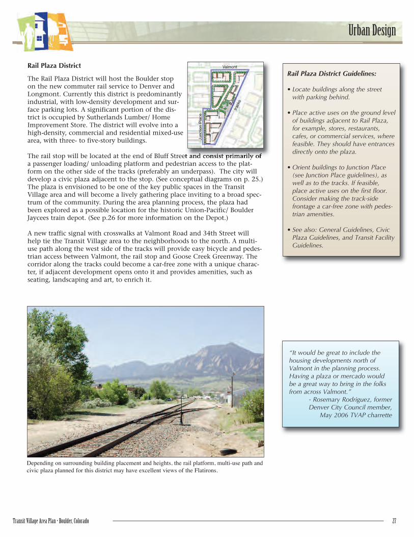
Rail Plaza District
The Rail Plaza District will host the Boulder stopon the new commuter rail service to Denver andLongmont. Currently this district is predominantlyindustrial, with low-density development and sur-face parking lots. A significant portion of the dis-trict is occupied by Sutherlands Lumber/ HomeImprovement Store. The district will evolve into ahigh-density, commercial and residential mixed-usearea, with three- to five-story buildings.
The rail stop will be located at the end of Bluff Street and consist primarily ofa passenger loading/ unloading platform and pedestrian access to the plat-form on the other side of the tracks (preferably an underpass). The city willdevelop a civic plaza adjacent to the stop. (See conceptual diagrams on p. 25.)The plaza is envisioned to be one of the key public spaces in the TransitVillage area and will become a lively gathering place inviting to a broad spec-trum of the community. During the area planning process, the plaza hadbeen explored as a possible location for the historic Union-Pacific/ BoulderJaycees train depot. (See p.26 for more information on the Depot.)
A new traffic signal with crosswalks at Valmont Road and 34th Street willhelp tie the Transit Village area to the neighborhoods to the north. A multi-use path along the west side of the tracks will provide easy bicycle and pedes-trian access between Valmont, the rail stop and Goose Creek Greenway. Thecorridor along the tracks could become a car-free zone with a unique charac-ter, if adjacent development opens onto it and provides amenities, such asseating, landscaping and art, to enrich it.
Depending on surrounding building placement and heights, the rail platform, multi-use path and
civic plaza planned for this district may have excellent views of the Flatirons.
Valmont
track
s
Junction P
lace

28 Transit Village Area Plan • Boulder, Colorado
Urban Design
Civic Plaza Guidelines2:
• Design the plaza to be approxi-mately a third of an acre. Err onthe side of smaller rather thanlarger.
• Frame the plaza with buildings,with one side open (or partiallyopen) to Bluff Street and/orJunction Place. The intent is tocreate a partially enclosed spacethat is both inviting and intimate.
• Provide flexible space to accom-modate a variety of public uses,such as a mercado3, farmers’market, and festivals. Also pro-vide flexibility for different usesduring different times of the day,week and year. Anticipated usesand associated maintenanceshould be an integral part of theplaza design, particularly layout,furnishings, materials and plantselection.
• Design the plaza so its use couldbe combined with temporary clo-sure of the east end of BluffStreet for special events.
• Include a variety of smaller“places” (activities or destina-tions) within the plaza. Thesecould be as simple as a vendorcart.
• Provide essential and “comfort”amenities such as bike racks, adrinking fountain, recycling andtrash receptacles, pedestrian-scale lighting, shade and soft sur-faces, in carefully chosen loca-tions.
• Provide an adequate amount ofseating and carefully consider itslocation, orientation, type andmaterials.
• Consider including active art andwater features, especially for chil-dren.
• Look for opportunities to incor-porate art into built elements,such as paving, railings, signage,seating or overhead structures.
• Incorporate environmentallyfriendly features such as pervioussurfaces, bio-filter landscapingbeds, high-efficiency lighting, andsolar-powered amenities (e.g.,bubble fountains). Explore possi-ble demonstration or educationalaspect for these features.
• Use high-quality, authentic mate-rials.
• Utilize trees and plants to softenthe space.
• Carefully design the new pedes-trian underpass (or overpass) atthe tracks so that it does not neg-atively impact the aesthetics orfunction of the plaza.
• Provide way-finding features,such as signage, special pave-ment and art, to direct people tothe plaza from 30th Street, BluffStreet, Valmont Road, JunctionPlace, and Pearl Parkway.
• Design the plaza to appeal toand attract a diversity of usersfrom throughout the community.Involve cultural groups and adja-cent neighborhoods in the plazadesign process, particularly resi-dents north of the area.
• Actively manage the plaza toensure on-going security, cleanli-ness and liveliness. Gear eventsto attract both existing users andnew users. Program uses tochange as the seasons change.
2 Some of these guidelines are based on “Ten
Principles for Creating Successful Squares”
by Project for Public Spaces.
3 The Spanish word for market, a mercado is
a public gathering place for buying and sell-
ing merchandise typically focusing on the
Mexican culture and/ or international wares.
Plaza Examples in Boulder• One Boulder Plaza - ice rink in the win-
ter, café seating and fountain the rest ofthe year, bordered by restaurants, cafésand offices; .25 acres
• Dushanbe Teahouse Plaza – used forBoulder County Farmer’s Market, adja-cent café seating; .16 acres
• Boulder County Courthouse Lawn –lawn and bench seating, fountain, pathnetwork, borders Pearl Street Mall; .65acres
• CU UMC/ Trumbo Fountain Plaza –stair seating enclosed by buildings onthree sides; .38 acres
Well-used One Boulder Plaza is framed by buildings
but also is accessible from three sides.
An interactive water feature can attract children and
families.
Transit Village Area Plan • Boulder, Colorado 29
Urban Design
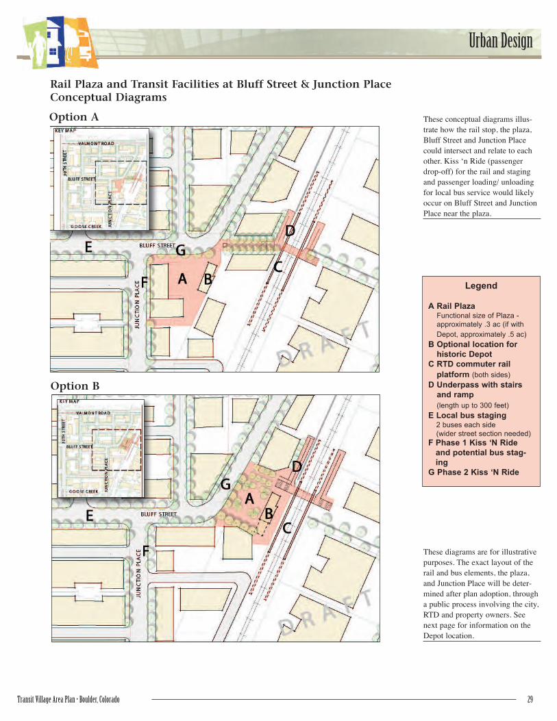
Legend
A Rail PlazaFunctional size of Plaza -
approximately .3 ac (if with
Depot, approximately .5 ac)
B Optional location for
historic Depot
C RTD commuter rail
platform (both sides)
D Underpass with stairs
and ramp
(length up to 300 feet)
E Local bus staging2 buses each side
(wider street section needed)
F Phase 1 Kiss ‘N Ride
and potential bus stag-
ing
G Phase 2 Kiss ‘N Ride
These conceptual diagrams illus-
trate how the rail stop, the plaza,
Bluff Street and Junction Place
could intersect and relate to each
other. Kiss ‘n Ride (passenger
drop-off) for the rail and staging
and passenger loading/ unloading
for local bus service would likely
occur on Bluff Street and Junction
Place near the plaza.
These diagrams are for illustrative
purposes. The exact layout of the
rail and bus elements, the plaza,
and Junction Place will be deter-
mined after plan adoption, through
a public process involving the city,
RTD and property owners. See
next page for information on the
Depot location.
Rail Plaza and Transit Facilities at Bluff Street & Junction PlaceConceptual Diagrams
Option A
Option B

30 Transit Village Area Plan • Boulder, Colorado
Urban Design
1890 Union-Pacific/ Boulder Jaycees Depot
In early 2006, the City Council indicated a preference for relocating thehistoric depot from the Crossroad Commons shopping center to theTransit Village area. Placing the Depot in proximity to the area's futuretransit uses would help recapture the historic significance of the Depot, adesignated city landmark. The exact location and future use, ownershipand management of the building will be determined through implemen-tation of the area plan.
The city housing site is likely to be the Depot's permanent location. Analternative location on the RTD site will be considered during masterplanning of the city/RTD site. A location near the bus facility or railroadtracks would more closely associate the building with its original transitfunction. During the area planning process, locations in the civic plazanear the rail stop to the north were explored (see diagrams on previouspage). However, they did not appear to be feasible at the time of planadoption, given the required schedule and available funding for relocatingthe Depot from Crossroad Commons.
Whether the Depot is permanently located on property owned by a publicentity, such as RTD or city housing, or owned by a private entity, the citywill compensate the landowner. Possible methods for the city to acquireDepot land include: direct purchase, dedication by the property owner inassociation with a development application, long-term lease, or trade forcity land elsewhere, or a combination of these methods.
Depot Guidelines:
• Ensure that the building's historicintegrity is restored and preservedfor future generations. Considerwhether funding and land shouldbe sought for restoration of thepavilion and porte-cochiere.
• Ensure that the building is anenriching centerpiece for the area,with a vibrant use, both day andnight. Ideas for uses include:restaurant or café; retail/entertain-ment; public meeting space, possi-bly in a basement; bike station; ortransit-related function. Other pos-sible uses may emerge. Two ormore uses could potentially becombined.
• Place the building in a highly visi-ble, easily accessible location, iffeasible given with surroundingland uses and programmaticneeds.
• Try to minimize storage time andrestore the building to active usesas soon as possible. Ensure thebuilding is stable, well-protectedfrom the elements and secure dur-ing movement and storage.
The Union Pacific/ Boulder Jaycees Depot was built in 1890
in Romanesque Revival style. See Appendix 6 for more histo-
ry on the building.
At the time of plan adoption, the most likely location for the Depot was the
east side of the city housing site.
Depot Location

Transit Village Area Plan • Boulder, Colorado 31
Urban Design
Valmont Corridor District Guidelines:
• Screen parking areas adjacent tothe street with landscaping and/orlow walls.
• Where additional access is provid-ed by new streets or alleys (seeChapter 4: TransportationConnections Plan), eliminate drive-way curb cuts on Valmont and30th streets or combine withadjoining properties.
• See also: General Guidelines.
30th Street Corridor District Guidelines:
• Locate buildings along the streetwith parking behind.
• To create a more pedestrian environ-ment and improve safety and trafficflow along 30th Street, eliminatedriveway curb cuts on 30th Streetwhen new streets and alleys aredeveloped in the vicinity. (SeeChapter 4: TransportationConnections Plan.)
• Provide pedestrian interest along30th Street by selecting activeground-floor uses, such as retail andcommercial services, where feasible.
• Provide street furnishings, such asbenches, planters, café seating, art,and pedestrian lighting.
• See also: General Guidelines.
30th Street Corridor District
Currently the 30th Street Corridor District ismostly zoned transitional business (BT1). Thewest side of 30th Street is predominantly auto-mobile-oriented retail or storage uses; the eastside of 30th Street is predominantly mixed-use,urban storefronts.
With a change to a mixed-use designation, thedistrict will evolve to take on the character setby the Steelyards project: a mixture of commer-cial and residential uses in two- tothree-story buildings located along thestreet, with parking behind, supportedby a network of new streets and alleys.The vision is to transform 30th Streetinto a business main street, withneighborhood and community-servingretail, restaurants, commercial servicesand offices. New transportation con-nections, wide sidewalks, first-floorstorefronts, pedestrian-scale architec-ture, street trees and furnishings, andon-street parking will help create amore pedestrian-friendly 30th Street.New housing will most likely be located internally to properties, awayfrom 30th Street, and will range from townhouses to higher-density apart-ments.
Valmont Corridor District
The Valmont Corridor District is cur-rently a service commercial district, theonly such district in town, with low-intensity retail and commercial uses,including a gasoline station, personalservices, offices, and small-scale manu-facturing. Most of the buildings are onestory in height.
The plan preserves the district’s existingservice commercial land use designationand zoning (BCS - Business CommercialServices). However, this zoning does allowmore density than currently exists, sosome expansions and intensification ofthe district are likely. For example, someone-story buildings may add a secondfloor.
The district’s current automobile orienta-tion -- surface parking lots in front ofbuildings and individual-property curb cuts along Valmont Road and 30thStreet -- is expected to continue. The major improvement recommendedfor the district is to enhance the Valmont and 30th streetscapes with streettrees and detached sidewalks. Better access to the neighborhoods to thenorth will be provided by three new crosswalks on Valmont Road.
Thirtieth Street will evolve into a busi-
ness main street.
Small businesses typify the Valmont
service commercial zone.
30th
Str
eet
Bluff Street
Mapleton Ave
Valmont
30th
Str
eet
Valmont Street

32 Transit Village Area Plan • Boulder, Colorado
Urban Design
Steelyards District
Most of the Steelyards District was recently devel-oped by the Steelyards project, a mixture of hous-ing, shops and small-scale service businesses. Theindustrial uses on the north side of Bluff Street willtransition to high-density residential, such as urbantownhouses. The southern part of the district ismixed-use industrial, one- to two-story live/workunits.
Thirty-third Street will be transformed into Junction Place by widening andimproving the existing right-of-waywith pedestrian and bicycle amenities,as described in Chapter 4:Transportation Connections.
Steelyards District Guidelines:
• Locate buildings along the streetwith parking behind.
• Look for opportunities to createcar-free or car-reduced zones.
• See also: General Guidelines.
Old Pearl District
The Old Pearl District currently hasmostly service industrial uses. Theproposed industrial mixed-use landuse will allow one- to three-storylight industrial or service industrialuses with residential or live/workunits. Over time, non-traditionalhousing will be developed incrementally, while retaining the present indus-trial character, resulting in an eclectic mix of uses. A higher intensity mixed-use industrial zone on the east edge of the district is intended to provide foradditional building heights to help buffer interior properties from FoothillsParkway traffic noise. This district may be a feasible location for a greentechnology park.
A new street and a bridge overGoose Creek will create a connec-tion to Wilderness Place. A plazaand/or sculpture at the western ter-minus of Old Pearl Street couldmark the historic significance ofthe street as a remnant of an earli-er “skewed grid” that once con-nected downtown Boulder to thetown of Valmont, and celebratethe current importance of PearlStreet.
Old Pearl District Guidelines:
• Locate buildings along the streetwith parking behind.
• For properties between Old Pearland the North Boulder Farmer’sDitch, orient the buildings to thestreet, but also take advantage ofthe ditch amenity.
• Orient buildings adjacent to theGoose Creek Greenway to thatamenity.
• If possible, place higher buildingsalong Foothills Parkway to helpbuffer traffic noise from residentialuses interior to the district.
• Work with the ditch company touncover the North BoulderFarmer’s Ditch where it’s currentlyunderground, re-vegetate thebanks, and integrate a new multi-use path. Do not underground theditch. Preserve any existing maturetrees.
• Provide direct access from adja-cent properties to the multi-usepaths along Foothills Parkway,Goose Creek and the ditch .
• See also: General Guidelines.
Housing surrounds a private park in the
Steelyards.
The mixed-use industrial land use proposed for
Old Pearl will allow live-work units.
Pearl Parkway Footh
ills P
ark
way
Junction P
lace
Bluff Street
Goose Creek
ditch
Old Pearl

Transit Village Area Plan • Boulder, Colorado 33
Urban Design
Pearl Parkway District Guidelines:
• Work with the ditch company touncover the North Boulder Farmer’sDitch where it’s currently under-ground, re-vegetate the banks, andintegrate a new multi-use path. Donot underground the ditch.Preserve any existing mature trees.
• Design buildings adjacent to theNorth Boulder Farmer’s Ditch totake advantage of that amenity.
• Provide direct access from adjacentproperties to the multi-use pathsalong the ditch and FoothillsParkway.
• See also: General Guidelines.
Wilderness Place District Guidelines:
• If possible, place higher buildingsalong Foothills Parkway to helpbuffer traffic noise from residentialuses within the interior of the south-ern portion of the district.
• Orient buildings adjacent to GooseCreek Greenway to that amenity.Provide direct access to the green-way.
• Provide direct access from adjacentproperties to the future multi-usepath along Foothills Parkway.
• Carefully design the pedestrianunderpass (or overpass) to minimizeits aesthetic and functional impacton nearby pedestrian areas.
• Provide way-finding features, suchas special pavements, signs andgraphics, to facilitate pedestrianmovement between WildernessPlace and the rail platform andunderpass (or overpass), Rail Plaza,Junction Place, Valmont, and theGoose Creek Greenway.
• See also: General Guidelines.
Wilderness Place District
Wilderness Place District is a stableemployment area, with a mixture of tech-nical offices and light industrial uses.Buildings range from one- story to four-stories. The proposed office-industrialland use will allow more density andgreater flexibility in types of office uses.This district (or Old Pearl or Pearl Parkwaydistricts) may be a feasible location for agreen technology park. In the longerterm, high-density residential may be devel-oped along Goose Creek.
A train platform and pedestrian underpass (or overpass) will be added atthe west edge of the district to serve the future commuter rail stop.Pedestrian walkways willconnect these toWilderness Place. A newstreet and bridge overGoose Creek will improveWilderness Place access tothe Old Pearl District andPearl Parkway and createan additional link fromthe south to ValmontRoad.
Pearl Parkway District
The Pearl Parkway District is industrialand functions as an extension of the EastPearl industrial area. Large warehousebuildings are located south of PearlParkway, and one- to two-story office andlight industrial buildings are locatednorth of Pearl Parkway. Parking is on sur-face lots. Two- to three-story office andindustrial uses are expected in thefuture. This district may be a feasi-ble location for a green technologypark.
Today the area of south of Pearl Parkway
has several large warehouse buildings.
The west edge of Wilderness Place District will have a
platform for the future rail stop.
Pearl Parkway
ditch
Valmont
Goose Creek
Footh
ills P
ark
way
Footh
ills P
ark
way
34 Transit Village Area Plan • Boulder, Colorado
Urban Design
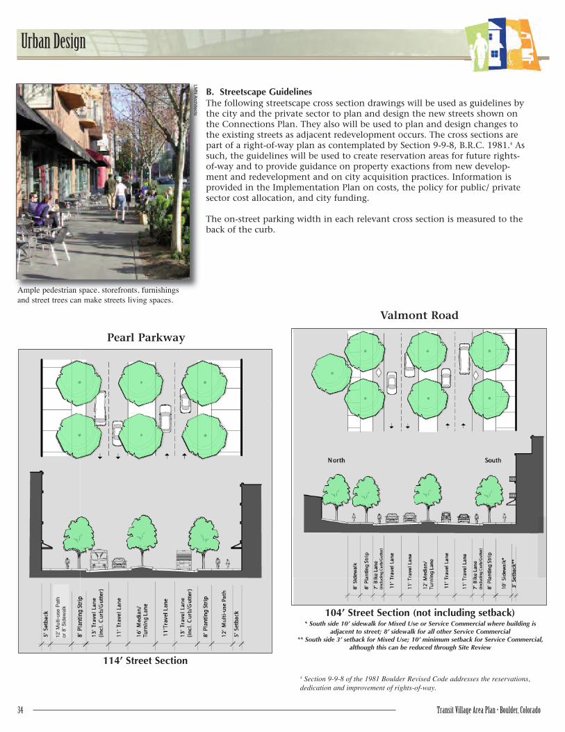
B. Streetscape GuidelinesThe following streetscape cross section drawings will be used as guidelines bythe city and the private sector to plan and design the new streets shown onthe Connections Plan. They also will be used to plan and design changes tothe existing streets as adjacent redevelopment occurs. The cross sections arepart of a right-of-way plan as contemplated by Section 9-9-8, B.R.C. 1981.4 Assuch, the guidelines will be used to create reservation areas for future rights-of-way and to provide guidance on property exactions from new develop-ment and redevelopment and on city acquisition practices. Information isprovided in the Implementation Plan on costs, the policy for public/ privatesector cost allocation, and city funding.
The on-street parking width in each relevant cross section is measured to theback of the curb.
Pearl Parkway
Valmont Road
104’ Street Section (not including setback)
114’ Street Section
Ample pedestrian space, storefronts, furnishings
and street trees can make streets living spaces.
12’ M
ulti-use P
ath
or
8’ S
idew
alk
* South side 10’ sidewalk for Mixed Use or Service Commercial where building is adjacent to street; 8’ sidewalk for all other Service Commercial
** South side 3’ setback for Mixed Use; 10’ minimum setback for Service Commercial,although this can be reduced through Site Review
4 Section 9-9-8 of the 1981 Boulder Revised Code addresses the reservations,
dedication and improvement of rights-of-way.
LM
N A
rch
itects
Transit Village Area Plan • Boulder, Colorado 35
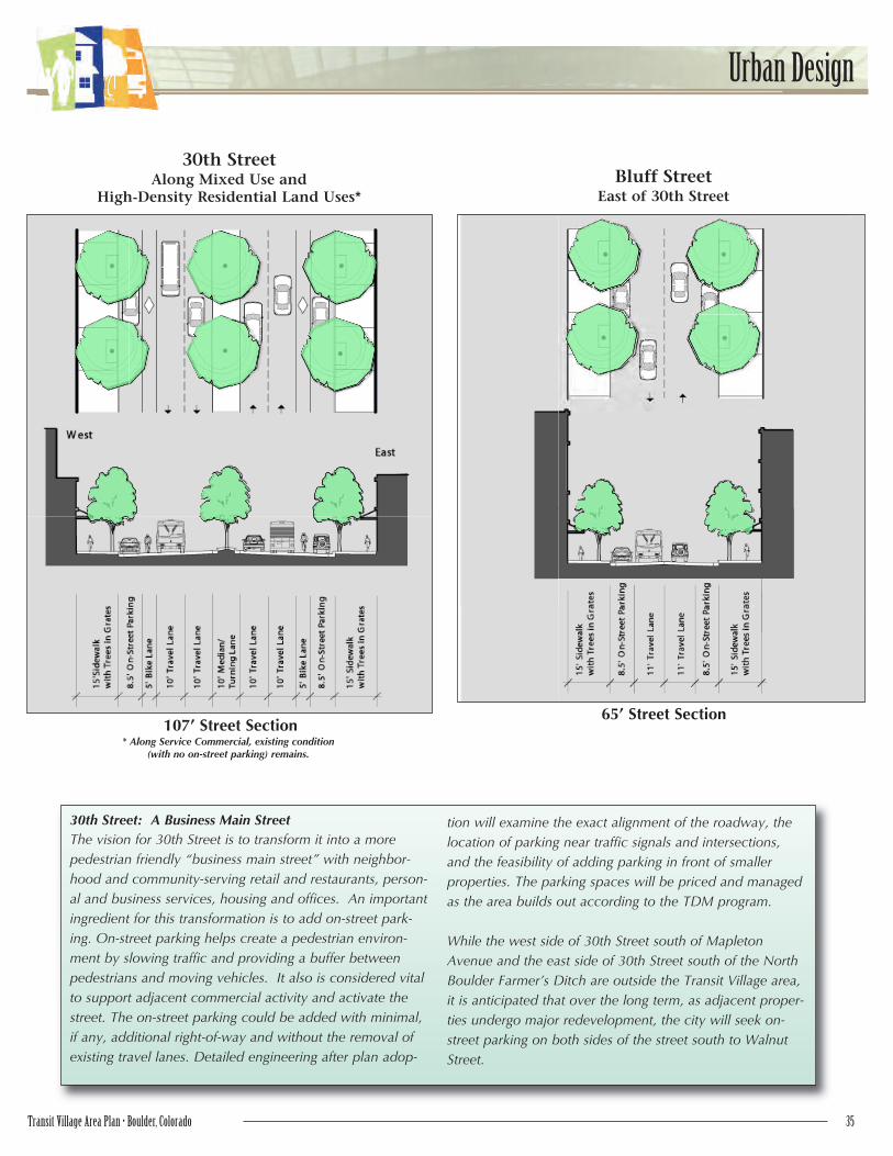
Urban Design
30th StreetAlong Mixed Use and
High-Density Residential Land Uses*Bluff Street
East of 30th Street
107’ Street Section65’ Street Section
* Along Service Commercial, existing condition (with no on-street parking) remains.
30th Street: A Business Main Street
The vision for 30th Street is to transform it into a more
pedestrian friendly “business main street” with neighbor-
hood and community-serving retail and restaurants, person-
al and business services, housing and offices. An important
ingredient for this transformation is to add on-street park-
ing. On-street parking helps create a pedestrian environ-
ment by slowing traffic and providing a buffer between
pedestrians and moving vehicles. It also is considered vital
to support adjacent commercial activity and activate the
street. The on-street parking could be added with minimal,
if any, additional right-of-way and without the removal of
existing travel lanes. Detailed engineering after plan adop-
tion will examine the exact alignment of the roadway, the
location of parking near traffic signals and intersections,
and the feasibility of adding parking in front of smaller
properties. The parking spaces will be priced and managed
as the area builds out according to the TDM program.
While the west side of 30th Street south of Mapleton
Avenue and the east side of 30th Street south of the North
Boulder Farmer’s Ditch are outside the Transit Village area,
it is anticipated that over the long term, as adjacent proper-
ties undergo major redevelopment, the city will seek on-
street parking on both sides of the street south to Walnut
Street.

36 Transit Village Area Plan • Boulder, Colorado
Urban Design
Junction PlaceSegment I
Southern Area Boundary to North Edge of Bus Facility Area
83’ Street Section
Junction Place as a Special Street
Junction Place will be a centralspine for the west side of the area.It will be designed to give priority topedestrians and keep vehicularspeeds low. Traveling the length ofJunction Place between PearlParkway and Valmont Road will bepossible but discouraged by thedesign and character of the street,as the street is not intended to func-tion as a through-street or north-south alternative to 30th Street.Rather, it is intended to provideaccess to the bus and rail facilitiesand adjacent neighborhoods fromnearby arterials.
For phasing and design purposes,Junction Place has been broken intothree segments. The exact alignmentfor each segment will be deter-mined at the time of redevelopmentof the adjacent properties throughSite Review. Comparative costs andimpacts to adjacent properties willbe considered. Phasing, funding andcost sharing for Junction Place isaddressed in the ImplementationPlan.
Junction Place will emphasize pedestrians and bicycles
over vehicles and will be enriched with amenities, such
as special paving.
Transit Village Area Plan • Boulder, Colorado 37
Urban Design
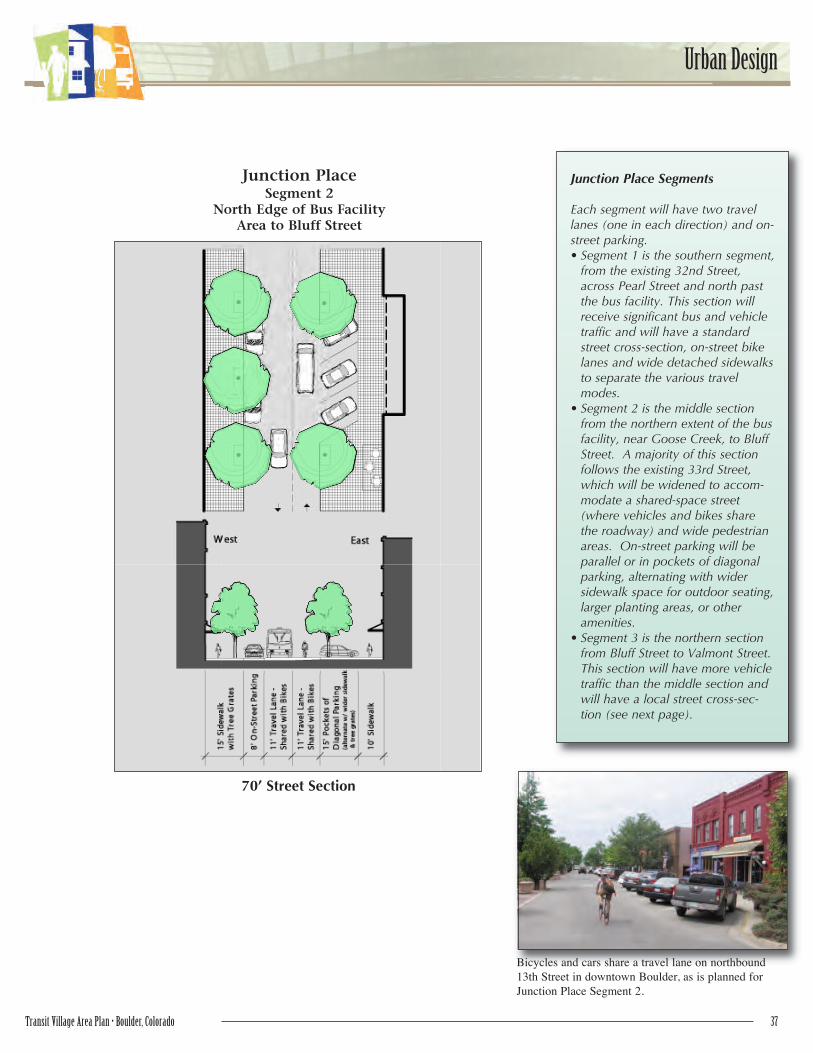
Junction PlaceSegment 2
North Edge of Bus Facility Area to Bluff Street
70’ Street Section
Junction Place Segments
Each segment will have two travellanes (one in each direction) and on-street parking.• Segment 1 is the southern segment,
from the existing 32nd Street,across Pearl Street and north pastthe bus facility. This section willreceive significant bus and vehicletraffic and will have a standardstreet cross-section, on-street bikelanes and wide detached sidewalksto separate the various travelmodes.
• Segment 2 is the middle sectionfrom the northern extent of the busfacility, near Goose Creek, to BluffStreet. A majority of this sectionfollows the existing 33rd Street,which will be widened to accom-modate a shared-space street(where vehicles and bikes sharethe roadway) and wide pedestrianareas. On-street parking will beparallel or in pockets of diagonalparking, alternating with widersidewalk space for outdoor seating,larger planting areas, or otheramenities.
• Segment 3 is the northern sectionfrom Bluff Street to Valmont Street.This section will have more vehicletraffic than the middle section andwill have a local street cross-sec-tion (see next page).
Bicycles and cars share a travel lane on northbound
13th Street in downtown Boulder, as is planned for
Junction Place Segment 2.

38 Transit Village Area Plan • Boulder, Colorado
Urban Design
Frontier/Wilderness Place
65’ Street Section 60’ Street Section
New or Upgraded Local Street
* A narrower roadway section - 32’ curb face-to-curb face, instead of 36’ curb face-to-curb face - may be allowed for land uses with lower density, lower intensity uses thanMixed Use-1 and -2, such as Mixed-Use Industrial-1 and High-Density Residential-1
Transit Village Area Plan • Boulder, Colorado 39
Urban Design
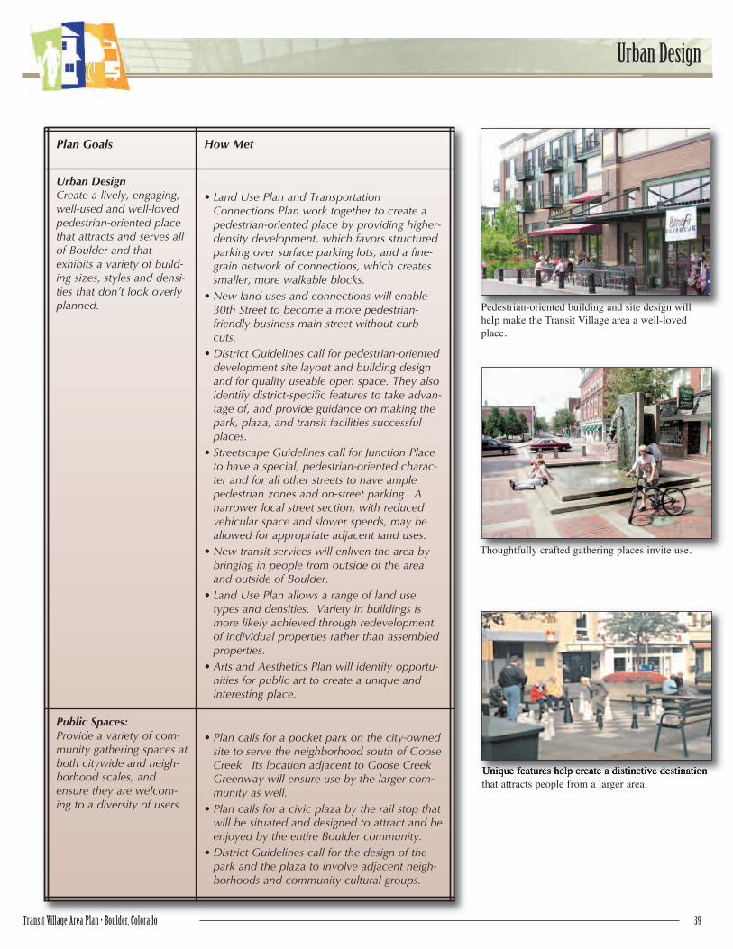
Pedestrian-oriented building and site design will
help make the Transit Village area a well-loved
place.
Thoughtfully crafted gathering places invite use.
Plan Goals How Met
Urban DesignCreate a lively, engaging,well-used and well-lovedpedestrian-oriented placethat attracts and serves allof Boulder and thatexhibits a variety of build-ing sizes, styles and densi-ties that don’t look overlyplanned.
• Land Use Plan and TransportationConnections Plan work together to create apedestrian-oriented place by providing higher-density development, which favors structuredparking over surface parking lots, and a fine-grain network of connections, which createssmaller, more walkable blocks.
• New land uses and connections will enable30th Street to become a more pedestrian-friendly business main street without curbcuts.
• District Guidelines call for pedestrian-orienteddevelopment site layout and building designand for quality useable open space. They alsoidentify district-specific features to take advan-tage of, and provide guidance on making thepark, plaza, and transit facilities successfulplaces.
• Streetscape Guidelines call for Junction Placeto have a special, pedestrian-oriented charac-ter and for all other streets to have amplepedestrian zones and on-street parking. Anarrower local street section, with reducedvehicular space and slower speeds, may beallowed for appropriate adjacent land uses.
• New transit services will enliven the area bybringing in people from outside of the areaand outside of Boulder.
• Land Use Plan allows a range of land usetypes and densities. Variety in buildings ismore likely achieved through redevelopmentof individual properties rather than assembledproperties.
• Arts and Aesthetics Plan will identify opportu-nities for public art to create a unique andinteresting place.
Public Spaces:Provide a variety of com-munity gathering spaces atboth citywide and neigh-borhood scales, andensure they are welcom-ing to a diversity of users.
• Plan calls for a pocket park on the city-ownedsite to serve the neighborhood south of GooseCreek. Its location adjacent to Goose CreekGreenway will ensure use by the larger com-munity as well.
• Plan calls for a civic plaza by the rail stop thatwill be situated and designed to attract and beenjoyed by the entire Boulder community.
• District Guidelines call for the design of thepark and the plaza to involve adjacent neigh-borhoods and community cultural groups.
Unique features help create a distinctive destination
that attracts people from a larger area.