urban catalyst
DESCRIPTION
Portfolio of Architectural Design Studio Spring 2009TRANSCRIPT

ANTONIONEVADAMARTINEZURBANCATALYSTSPRING09


ANTONIO NEVADA MARTINEZURBAN CATALYSTSPRING 09
Zhongjie Lin, Ph.DInstructor
CIUDAD MEXICO
CHARLOTTE, NC
Contextual Immersion + Urban Analysis
Precede
nt
Freedom Regional Library
Image of Southend
Site Analysis + Conceptual Design
Southend Regional Public Library
La UNAM LibrariesBiblioteca Vasconcelos by Alberto Kalach

5 km
5 km
Upon the rubble of the ancient Aztec Capital, thrives a rapidly growing metropolis in the tropical and volcanic highlands of Mexico. Aztec spirit remains rooted in the culture, but the spirit of colonialism still seeks to broaden the gap between the power and the native people of Mexico City. It thrives nonetheless, and people pour in hourly. Its area is the third largest in the world, and there is just under 20,000,000 people who are the blood of the transit system second in size to NYC. The Sistema de Transportive Colectiva (bottom) Metro is the least expensive rail to ride in the world, and free to those who are elderly or disabled. Because it is along a major trade and immigration route, the city is not free from automobile pollution, industrial waste, illegal activity, corruption and poverty. President Vicente Fox sought to remedy the desperation causing the previously mentioned social by products with a renovation of the public realm. This included expanding railway infrastructure, mainly to open up international trade and transportation. The main node is adjacent to the Mexican National Library dedicated by Fox in 2006 to philosopher Jose Vasconcelos (bottom right). It contained ample public space and resources, and is located directly next to the Estacion de Buenavista Metro stop. A historic beginning of the B-line, this station is within fifteen kilometers of anywhere in Mexico City. The library’s site is deep in a district of densely populated residential and exploding commercial growth. The heart beats loudly in this region of the world .
CIUDAD MEXICO

During spring break I travelled to Mexico City to explore an alternative urban context and visit the architecture department at the Universidad Nacional Autonomo de Mexico (La UNAM). This trip occurred in the middle of the semester, after doing a precedent study and examining the urban context of Charlotte, NC. In Mexico I was able to see how a pedestrian friendly city interacts with its inhabitants, which was a major part of the Urban Catalyst project. My colleague and I rode the STC Metro rail to every corner of the expansive city in one week. It was an enlightening experience in that we were able to see the multiple layers of urban fabric that occur at street level after I had done the urban analysis on the previous page. I was intrigued most by the courtyard spaces behind the building “edges” that acted as intermediate nodes between the dense urban fabric and the peoples dwellings. Also, Mexico City has a multitude of public spaces that are compltely free, as public space should be, compared to the retail based “public space” that exists in Charlotte. My project would later emulate this phenomenon.
Contextual Immersion + Urban Analysis

The Universidad Nacional Autonomo de Mexico was one of the gems in the city. The most recent revolution was borne here and the optimistic and active spirit of the people can be seen in the buildings on campus. The campus also has copious public space that is almost constantly being inhabited due to the warm climate which hovers around eighty degrees Fahrenheit year round. The first library I visited was near the main campus entry. I noted it for its transparent entry atrium and having the security at the 2nd floor, next to the vertical circulation. This allowed for the first floor to be free flowing and a transitional space into the functional spaces of the library itself. The former Biblioteca Nacional (bottom 4) was the second library I visited, and is not easily forgotten. The facade is a mosaic that represents the struggle of the native people against the European invasion and overtaking. Inside, there are twenty plus stories of functional space atop a double height main floor complete with study areas, an overhanging computer area, and massive circulation desk at the center.
CIUDAD MEXICO
Bibliotecas de la UNAM

The third and final library that I visited was the Architectural Resource Center. It is connected to a cafeteria and has a transitional gallery space before entering the secure area. There are several student and faculty projects on display as well as an artist’s arrangement of photographs and renderings. The top floor (top) has archival and staff offices with transparent walls and doors. It is accessible from a staircase next to the entrance. The main floor has stacks located underneath the offices with a double high reading and study area adjacent to the books. At the core is a book elevator and the circulation desk. Below that is another room full of general collections that is day lit by large courtyard windows, which the reading areas are situated directly adjacent to. This library uses its secondary spaces very creatively, especially the spaces under stairs, which are prime study and gathering areas.
Libraries of UNAM

CIUDAD MEXICO
Bibliotecas VasconcelosFor the first time in a century, Mexico announced an international competition for the design of its national library in 2006. The winning entry by Mexican architect Alberto Kalach was to be the largest in Latin America at 38 square kilometers. Oriented orthogonally along the sliver of space adjacent to the old Buenavista train station, the reinforced concrete + exposed steel “megalibrary” shares its site with a botanical garden. The uneven terrain is articulated by plant growth to provide ample courtyard space, fluid circulation, and an experience reminiscent of Tenochtitlan. All of the transitions down into the building are under an elevated forest plain (below), and the threshold into the temple of knowledge is most impressive axially (right). From entry level, one can see the entire length of the corridor. North facing sawtooth windows illuminate the vast expanse of bookshelves, which are suspended from the trusses. It has been deemed a “tomb for books” by several critics and controversially closed for 22 months, but now serves as an infrastructural node for thousands of gracious citizens who use the 750 free internet ports next to two rail terminals. Kalach was raised in the Distrito Federal, which is within walking distance of the crucial urban ventricle that became the context for his most ambitious project.

by Alberto KalachBiblioteca Vasconcelos
N
30
W
S
E
150210
330
300 60
120240
a.m.p.m.
10
20
30
40
50
60
70
80
90
quatorast
oonorth
7:06
7:25
6:59
18:54
19:33
20:18
0
mexico city19.5 N99 W

CHARLOTTE, NCFreedom Regional LibraryPlans
Circulation Diagrams
Spatial Hierarchy Diagrams1st Floor 2nd Floor

Freedom Regional LibraryThis library provided a lesson in programattic flexibility by having very little. I learned the importance of placing reading areas in well lit spaces, computer areas in darker ones, and properly lighting general collections and stacks. This library also forgot to account for bulletin space, but had a very clearly marked set of circulation and information desks.

CHARLOTTE, NC
Image of SouthendBased on Kevin Lynch’s book Image of the City, the following pages are an analysis of Charlotte’s Historic Southend District. The five categories of diagrams are Edges, Districts, Nodes, Paths, and Landmarks. The map to the left has a sunpath diagram overlaid to illustrate my ecological consciousness throughout the process.
N
30
1000 feet
N30
W
S
E
150
210
330
300
60
120
240
a.m.
p.m.
10
20
30
40
50
60
70
80
90
quatorast
oonorth
7:06
7:25
6:59
18:54
19:33
20:180
N30
W
S
E
150
210
330
300
60
120
240
a.m.
p.m.
Lagos: 5.5 degrees N
10
20
30
40
50
60
70
80
90
quatorast
oonorth
6:52
6:36
6:33
18:37
18:45
19:04 0
LAGOS NIGERIA
mexico city
19.5 N
99 W
N30
W
S
E
150
210
330
300
60
120
240
a.m.
p.m.
10
20
30
40
50
60
70
80
90
quatorast
oonorth
7:28
7:11
6:09
17:15
19:36
20:010
Charlotte, NC
35.2 N
80.8 W

EDGES
N
30
1000 feet
HIGHWAY 277 reinforced by uptown
LIGHT RAIL divides east from west
not always a solid edge
SUBURBIA darkness at night degrades
the sense of security
pedestrian traffic not supported
building typologyreinforces edge
IDEAL WAYREMOUNT ROAD
reinforced by lack of pedestrian traffic and
industrial presence

N
30
1000 feet
LOW DENSITY RESIDENTIAL
single family housing
low income in wilmorehigh income in dilworth
SOUTHENDCURRENT
DEVELOPMENThigh end retail, office, and residential space.
LOCALHISTORICAL
locally owned/operatedrestaurants, galleries, shops
retired or renovated evidence of industrial
charlotte
public buildings
INDUSTRIAL
HIGH END MIXED USElofts and condominiums
multifunctional office and retail spaces
corporate franchise
DISTRICTS

N
30
1000 feet
carson blvdbland street
east/west blvdLIGHT RAIL STATIONS (3)
URBAN ROOMS courtyards
squaresalleyways
C.A.T.S. STOPStryon st line 16
west blvd line 36midtown line10
gold rush trolley
3 min walk
automotivepedestrian
SUBSTANTIAL INTERSECTIONS
NODES

PATHS
N
30
1000 feet
LIGHT RAIL CORRIDORS. TRYON BLVD
core of district supportsall three forms of
transportation
pedestrian paths border and intersect with automotive
SOUTH BLVDdynamic pedestrian
circulation possibility
very distinctive building characteristics all along
LYNX BLUE LINECHARLOTTE TROLLEY
dynamic railcirculation possibility
historical trolleyadds nostalgic value
and sense of place

LANDMARKS
N
30
1000 feet
The Arlington Luxury Condos
THE PINK BUILDING
WATER TOWERCamden Square
Design Center of the Carolinas
SOUTHEND SMOKE STACK
Atherton Cotton Mills
Charlotte Trolley Station

The site is located in the heart of the Historic Southend district. It includes the Fowler building, which is a renovated masonry building with little historical significance, but is still useful. There are sufficient veiws to uptown to the northeast as well as further into southend to the southwest. Proximity to the Lynx Light rail Bland Street stop is probably the most significant aspect of the site’s urban context. There is also a five point intersection on the other side. These two nodes became the focus of my project. As an urban catalyst, a building should respond to its proximity to such nodes by creating a clear linkage and ample pathways between them.
CHARLOTTE, NC35.2 Noth Latitude80.1 West Longitude
URBAN CATALYST

These photographs were taken from the top of the Fowler building, and at ground level. They were to aid in establishing a visual context of the surrounding area. The top photo is to the north, then they move east 360 degrees.
Conceptual Design

CHARLOTTE, NC35.2 Noth Latitude80.1 West Longitude
URBAN CATALYSTThe focus of my project was to establish a clear pedestrian node at the Tryon + Camden intersection, where it was lacking one. Also, I wanted to link the new node with the light rail stop. The central core of the building was to serve as a node within, an urban “room”, and a courtyard space for public use. The central courtyard would be surrounded with vegetation to distribute daylight more evenly.

Conceptual DesignThree models used in analyzing sunlight penetration into the central courtyard.

CHARLOTTE, NC35.2 North Latitude80.1 West Longitude
URBAN CATALYSTThese sections were developed during the process of establishing structure and vertical circulation within the main courtyard.
Red indicates Primary Vertical Circulation Ramps
Structural Diagram with Tension + Compression

Conceptual DesignRenderings from the first iteration. It was abandoned due to the extreme nature of the structural system, which took away from the original idea of a purely open courtyard and first floor. The centerpiece was to be a polished metal sphere suspended by cables, all to counterbalance the tensile forces produced by suspending the outer planters.

CHARLOTTE, NC35.2 North Latitude80.1 West Longitude
URBAN CATALYSTThese photos were taken of the massing model in its site context.The top photo is from the north, above the light rail station. The bottom photo is in plan view

Southend Regional Public LibrarySite Plan

Southend Regional Public LibraryGround Floor1/16” = 1’

Southend Regional Public Library2nd Floor1/16” = 1’
3rd Floor1/16” = 1’

Southend Regional Public LibraryElevations :
from Tryon Street
from Lightrail Stop
from Uptown
from Southend
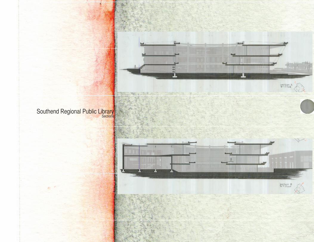
Southend Regional Public LibrarySections

Southend Regional Public LibraryFinal Model
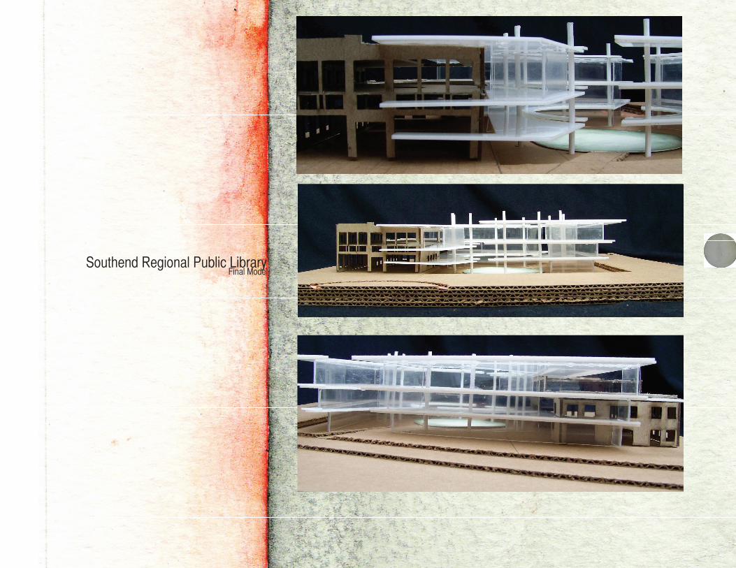
Southend Regional Public LibraryFinal Model

Southend Regional Public LibraryRenderings :
Approach
Entrance

Southend Regional Public LibraryRenderings:
Balcony
Courtyard
