upper rother valley - home – east sussex … park lake and lakedown trout lake at holmhurst manor....
TRANSCRIPT
© ESCC 2016
Upper Rother Valley
The East Sussex County Landscape Assessment The
High
Wea
ld
6© Crown copyright all rights reservedEast Sussex County Council1000196012004
FlimwellTicehurst
Wadhurst
Mayfield
Stonegate
A265
River Rother
Broad Oak
BurwashHolmhurst
Heathfield
Robertsbridge
A267
B2099
Burwash Common
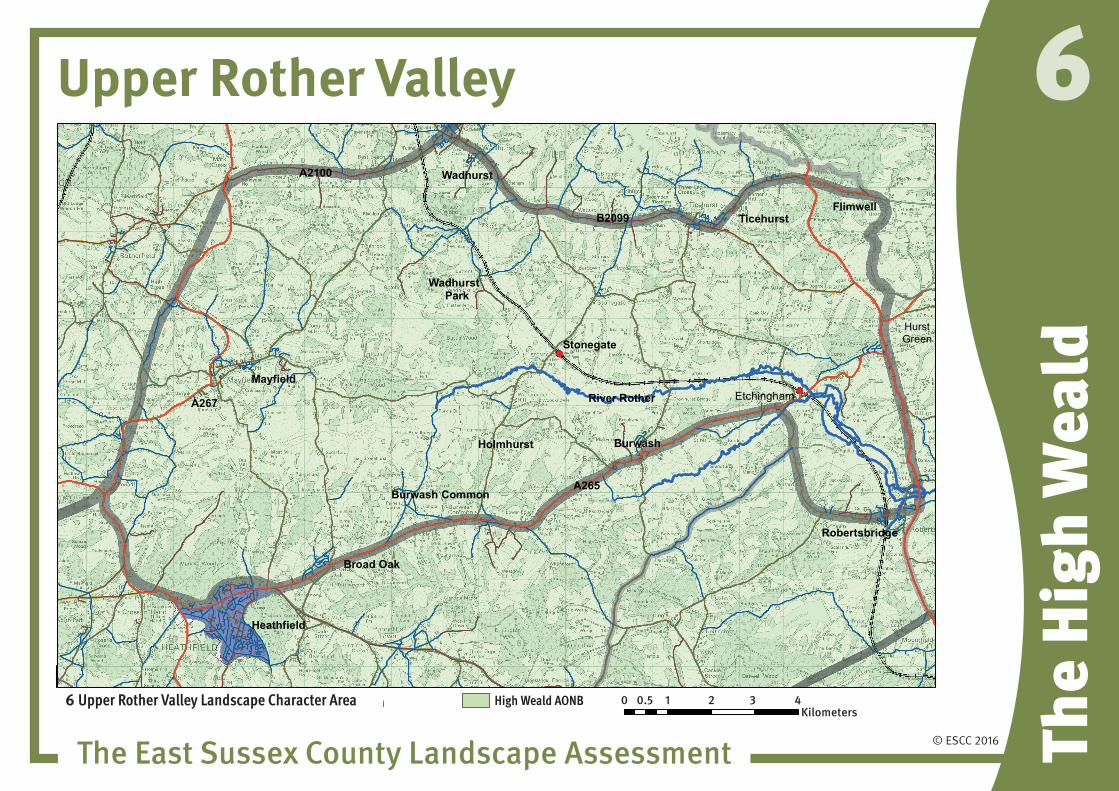
6 Upper Rother Valley Landscape Character Area
Wadhurst Park
A2100
Etchingham
High Weald AONB 0 1 2 3 40.5Kilometers
HurstGreen
6 Upper Rother Valley Landscape Character Area High Weald AONB 0 0.5 1 2 3 4Kilometers

© ESCC 2016
Upper Rother Valley
The East Sussex County Landscape Assessment The
High
Wea
ld
6
relatively open valley floorwith small, winding, partly tree-lined river
valley overlooked by spurs with ghylls and shaws fine views across valley
broad valley of Upper Rother broadens eastwards
designed landscapes and parkland
settlements and roads along ridges at edges of area
© ESCC 2016
Upper Rother Valley
The East Sussex County Landscape Assessment The
High
Wea
ld
6ContentsA. Landscape DescriptionB. Landscape EvaluationC. Vision and StrategyD. Guidelines for Managing Change
A Landscape Description Key Landscape characteristics
• ThelargersettlementsonhighgroundofMayfieldinthewest,WadhurstandTicehurstinthenorth,HurstGreenintheeastandBurwash to the south.
• Mayfield,RobertsbridgeandWadhurstarenucleatedvillageswhich have grown around a historic core.
• Othersettlementshavegrownasribbondevelopmentsstrungalong the main roads which follow the ridges on the boundaries of the area.
• ThevillageofRobertsbridgeonlowergroundadjacenttotheriverwasvulnerabletofloodinguntilrecentmajorfloodprotectionmeasures were constructed.
• ThebroadvalleyoftheRiverRotherdominatesthelandscapeand is overlooked by bold ridges and spurs.
• Stunningviewsacrossthevalleyfromtheenclosingridges,someofthefinestviewsintheHighWeald.
• TheupperhalfofthelargestvalleysystemintheHighWealdandthe catchment and source of the western river Rother.
• Rolling,richlywoodedlandscapecentredontheflatmainvalleywhich broadens in the east.
• Relativelyopenvalleyfloorwithsmall,winding,partlytree-linedriver.
• Largeintensivelygrazedorcroppedfieldsonthelowervalleyslopes and patterns of smaller medieval fields on the steeper slopes.
• TheRotherregularlyfloodsturningthewholevalleybottomintoahuge sheet of water.
• Astrongpatternoflinearghyllwoodsaswellasmanylargerwoods on the valley slopes.
• Extensiveareasofremotecountrysideandexceptionalremoteness especially in the valleys and larger woods.
• Thevillageshavegreatcharacterandvarietyoftenwithlandmarkchurches and other historic buildings.
• ‘Picturesque’farmsandcottagesandscatteredhistoricfarmsteadswhichareakeycharacteristicoftheHighWeald.
• Manyofthewoodsareancientsemi-naturalwoodlandwithextensiveareasreplantedwithchestnutcoppicemixedwithconifers.
• Characteristictreespeciesareofchestnut,larchesandpinesonthesandysoilsoftheAshdownbeds.
• Oak,hornbeamandashpredominateinthelargerwoodlandswithhazelunderstorey.
• Ancientcoppicestoolsofchestnutandhornbeamwhichhavenot been managed for many years.
• Othercharacteristicspeciesarefieldmaple,wildcherryandalder and willow in the river and stream valleys.
• Manyscatteredfarmpondsandlargerhammerpondsasrelicsoftheironindustrywhichthrivedinthisareae.g.WadhurstParkLakeandLakedowntroutlakeatHolmhurstManor.
© ESCC 2016
Upper Rother Valley
The East Sussex County Landscape Assessment The
High
Wea
ld
6• Aclosenetworkofwinding,sunkenlaneswithscattered
settlements and individual dwellings often strung out along them.
• Traditionalbuildingmaterialsfortheareaareredbrick,oftenlaid as Flemish bond with blued brick ends, red tiled roofs and tile hung upper stories are typical.
• Oaktimberframedandsandstonehousesreflecttheabundanceoflocallysourcedtimberandquarriedstone.
• TherearenomainroadscrossingtheareabuttheA265formsthesouthernboundaryandtheA267andA21crossthewestandeast edges respectively.
• TheHastingstoTunbridgeWellsrailwayfollowsthevalleyfromRobertsbridge to Wadhurst.
Cultural InterestsTheareawasthecentreoftheWealdenironindustrywhichthriveddue to the abundance of available timber and water and good transport routes to the sea.
Thisisreflectedinlocalplacenamesandthemanyforgesandmills.Manyofthefinehousesandlargeestatesintheareaalsogrewfromthewealthgeneratedbytheindustry.Thefinehouseswhichline the streets of the larger villages date from the time of the iron industry boom.
In the 18th century the area was known for smuggling of wool, silk andbrandyparticularlyaroundthevillageofMayfield.thiswasfacilitatedbygoodroadaccesstothecoastalportsofHastingsandRye.Theremoteandwoodedcharacteroftheareaprovidedhidingplaces for smugglers and their contraband.
ThemaintollroadfromHeathfieldtoBurwash,nowtheA265wasanotorious haunt for highwaymen.
BeforetheBeechingcutsMayfieldwasservedbytherailwayfromEastbournetoLondon,thetrackwasusedasthelineforthevillageby pass which was constructed in the early 1990s.
TherearemanyhistoricbuildingsscatteredacrosstheareaandsomeofthemorenotableonesareAbbotsHouse(1250)whichistheonlyremainingpartofRobertsbridgeAbbey.HaremereHallatEtchingham dates to the early 1600s.
Theareahasattractedmanyfamousandwealthyresidentsprobablydue to the relative remoteness and beauty of the area and ease ofaccesstoLondon.WadhurstParkishometotheTetraPacbusinessmanHansRausingandhislargecollectionsofraredeer.HolmhurstManorhasbeenhometoRogerDaltryoftheWhosincethe1970s.RobertSmith,leadsingeroftheCure,livesinBurwashand Jeff Beck the guitarist lives in Wadhurst.
OthernotableresidentswerethecricketerAlbertRelf(1874-1937)whowasborninBurwash.AndrewYoungthewriterandpoetwasvicarofStonegatefrom1941-1959.
Robertsbridge is known for the production of cricket bats founded byGray-Nichollsin1876andusinglocallysourcedwillowwood.
HMSEtchinghamwasnamedafterthevillageasallofthe93minesweepersbuiltbetween1954and‘59oftheham class which were designed for the shallow waters around our coasts were named after places ending in ham.

© ESCC 2016
Upper Rother Valley
The East Sussex County Landscape Assessment The
High
Wea
ld
6Table 1 Key positive Landscape Attributes
• ThebroadvalleyoftheRiverRotherdominatesthelandscape and is overlooked by bold ridges and spurs.
• Stunningviewsacrossthevalleyfromtheenclosingridges,someofthefinestviewsintheHighWeald.
• TheupperhalfofthelargestvalleysystemintheHighWeald and the catchment and source of the western river Rother.
• Relativelyopenvalleyfloorwithsmall,winding,partlytree-lined river.
• Extensiveareasofremotecountrysideandexceptionalremoteness especially in the valleys and larger woods.
• Thevillageshavegreatcharacterandvarietyoftenwithlandmark churches and other historic buildings.
• ‘Picturesque’farmsandcottagesandscatteredhistoricfarmsteadswhichareakeycharacteristicoftheHighWeald.
• Astrongpatternoflinearghyllwoodsaswellasmanylargerwoods on the valley slopes.
• Manyofthewoodsareancientsemi-naturalwoodlandwithancient coppice stools of chestnut and hornbeam.
• Manyscatteredfarmpondsandlargerhammerpondsasrelics of the iron industry which thrived in this area e.g. WadhurstParkLakeandLakedowntroutlakeatHolmhurstManor.
• Aclosenetworkofwinding,sunkenlaneswithscatteredsettlements and individual dwellings often strung out along them.
• Traditionalbuildingmaterialsfortheareaareredbrick,often laid as Flemish bond with blued brick ends, red tiled roofs and tile hung upper stories are typical.
• Oaktimberframedandsandstonehousesreflecttheabundanceoflocallysourcedtimberandquarriedstone.
© ESCC 2016
Upper Rother Valley
The East Sussex County Landscape Assessment The
High
Wea
ld
6B Landscape EvaluationTable 2 Current Condition
Thisisalargelyunspoiltandtranquilrurallandscapewithfewintrusivefeatures.Thelandscapeisingenerallygoodcondition and well managed as farmland with a strong historic structure.Thelackofmainroadsandlargesettlementsin the heart of the area means that it retains a relative remoteness.Agriculturalchangeanddiversificationhasledtosomefragmentationoffarmsteads.Thereisevidenceofcreeping suburbanisation around the villages and on country estateswhichdetractsfromlocaldistinctiveness.Aswithmost of the wealden landscape the historic field patterns of small fields and significant hedgerows remain intact, apart from in the wider more fertile river valleys where farming is more intensive. Woodlands have been affected by lack of traditional coppice management, rhododendron invasion and coniferisation.
Forces for Change impacting on positive attributes
Past / Current forces for change
• RibbondevelopmentandmodernhousingdevelopmentsontheHeathfieldtoBurwashridge.
• Creepingsuburbanisationandcumulativechangesinthe rural landscape, roads and villages which are not in sympathy with local distinctiveness or vernacular architecture.
• Developmentpressuresinthelargervillages.
• Erosionofpublicrightsofwaywhereusersavoidthemuddy areas making tracks increasingly wider.
• Agriculturaldiversificationtohobbyfarmsandhorsiculture.
• Changesinthetypesandfrequencyofgrazinganimalsin the countryside impacts on character as they are acharacteristicfeature.Lackofgrazingcangiveanunmanaged appearance to the landscape and reduce the biodiversity value.
• Lossofunimprovedspeciesrichpasturesandhaymeadows.
• ThepositivelandmanagementinitiativesassociatedwiththeHighWealdAONB.
• Areasoflargescaleintensivearablefarmingwithlossofhedge structure, especially on the wider valley floors.

© ESCC 2016
Upper Rother Valley
The East Sussex County Landscape Assessment The
High
Wea
ld
6• FarmEnvironmentPlans,manyfarmsareunderEntryLevel
StewardshipincludingextensiveareasintheRotherValleytotheeastofMayfieldandsouthofWadhurstincludingWadhurstParkandHolmhurstFarm.Somefarmsarefarmedorganically,notablyClaytonFarmsouthofMayfield.
• Intrusivemodernfarmbuildings.
• Lossofriversidetreesduetoagricultureandfloodmanagement engineering works.
• Coniferisationoflargerwoods.
• Lossoftraditionalcoppicinginwoodlandsandincreaseingame shooting.
• WoodlandGrantschemesarescatteredacrossthearea,notablyHawksdenParkandNewbridgewoods,reversingthe trend of poor woodland management.
• Increasingtrafficonthemainroadswhichcrossthenorthand south of the area and rat running on rural lanes.
Future Forces for Change
• Theneedtoprovidelocalhousinginthevillages,especiallythe larger service centres.
• Theassociatedinfrastructurerequiredfornewdevelopment such as waste water treatment works.
• Trafficandratrunningonnarrowruralroads.Erosionoftheedges of sunken lanes by increasingly larger agricultural and other vehicles.
• Demandsfortrafficcalmingandroadimprovementswhichcould introduce increasing urban clutter to rural roads, villages and lanes.
• Continuedagriculturalchangeduetochangingmarkets,economic pressures and response to climate change.
• Thespreadofsmallagriculturalholdings,hobbyfarming,paddocks, farm shops and allotments for local food production.
• Pressureforlocatingrenewableenergyfacilitiesforsolar,wind and bio energy.
• Pestsanddiseasesoftreeswhichcouldimpactsignificantly on the mature tree stock. E.g. phytophora of alderandAshdieback.
• Failuretocontrolinvasivespeciesofplantsandanimalsinwatercourses,suchasNewZealandPigmyWeed(Crassulahelmsii),ParrotsFeather(Myryophyllumaquaticum),MinkandEuropeanMarshFrog(Pelophylaxridibundus).Allof these impact on the native flora and fauna which are characteristic of the area.
• WaterqualityintheRiverRothercatchment.

© ESCC 2016
Upper Rother Valley
The East Sussex County Landscape Assessment The
High
Wea
ld
6Table 3 Potential Impacts of Climate Change
• Potentialchangesinwoodland/treespeciescompositionand accelerated growth of species such as birch and rhododendron.
• Changesingroundflorawhichproducedistinctiveseasonaldisplays.
• Increasedprevalenceofpestsanddiseasesduetowarmerweathere.g.PhytopheraofAlder.
• Changesinprecipitationandtemperatureswillchangethetypes of crops that farmers grow.
• Morefrequentandseriousfloodeventsinthevalleybottoms.
• Potentialimpactontheviabilityofgrazingsheep,dairyandbeef.
• Increasedtemperaturesandadeclineinprecipitationlevelsmay dry out wetland habitats and ponds and alter stream flows.
• Changesinwaterlevelsinditches,pondsandstreams

© ESCC 2016
Upper Rother Valley
The East Sussex County Landscape Assessment The
High
Wea
ld
6C Vision and StrategyTable 4 Vision
Aremote,tranquilandpredominatelyrurallandscapeofrollingtypical high wealden countryside. Secluded valleys with ghyll woodlandsandwindingnaturalriverchannels.Alandscapewith a scattered settlement pattern of historic farmsteads and astrongpatternofwoods,treesandhedges.Thecharacterofexistingsettlementsretainedandnewdevelopmentcontrolledwiththehighestqualityvernaculardesignandspatialplanning.
AsnotedinthecurrentLandscapeCharacterGuidance– ALandscapeStrategyidentifies“what change if any is desirable for any landscape character area as a whole?”
Landscape change and adaptation to meet the strategy requires:
1. PlanningfortheenhancementoftheRother,BredeandTillinghamWoodsBiodiversityOpportunityArea(BOA).ThisaimstorestorewetlandsintheRiverRotherfloodzone.Thefocus in the upper tributary valleys is woodland management throughtheRotherWoodsProject.
2. Protectionandmanagementofexistingwetlandhabitatsandplanning for restoration of ditches, riverside vegetation and tree cover to restore habitat linkages and continuity.
3. Protectionandenhancementoftheremotequalitiesoftheriver valleys.
4. Planningforthecreationofmultifunctionalgreeninfrastructuretomaximisetheopportunitiesforbiodiversityandrecreationofferedbytherurallanes,rightsofwaynetworkandextensivewoodland.
5. Considerthepotentialtoplanforrecreationalaccessinthischaracter area identifying areas where public access can be encouraged whilst protecting other areas where wildlife conservation is the priority.
6. Integrateproposedandexistingdevelopmentintothelandscape through planting of tree features and woodland to define the town and village boundaries with the countryside.
7. Ensurethatthedesignandlayoutofnewdevelopmentsrespectthecharacterandformofthelandscapeandexistingsettlements.
8. Control the spread of suburbanisation by minimising clutter of signage and other urban features in lanes and villages.
9. Conserve the setting of historic buildings and landscape features.
10. Protectandenhancehistoricdesignedlandscapesandfeatures of archaeological significance.
11. Consider appropriate species for new plantings to maintain landscape character and biodiversity having regard to adaptation to climate change influences.
12. Restore and strengthen tree and woodland structure, encouraging woodland grant and farm conservation schemes and positive woodland management.
13. Encouragescreeningoffarmgroupsasacomponentoftheseschemes.

© ESCC 2016
Upper Rother Valley
The East Sussex County Landscape Assessment The
High
Wea
ld
6D Guidelines for Managing Change Development considerations for housing and other development
ProposalswithintheHighWealdAONBneedtohaveregardforthecurrentHighWealdManagementPlan:http://www.highweald.org/downloads/publications/high-weald-aonb-management-plan-documents/1141-high-weald-management-plan-3rd-edition-2014-2019.html.
Themainpressuresfordevelopmentinthischaracterareawillbetoaccommodate housing for the populations in the rural settlements ofMayfield,WadhurstandBurwash.Therewillinevitablybeademand for local housing in the smaller villages.
Tourismisanimportantsourceofincometothisareaandthereislikely to be increasing demand for accommodation in hotels, bed andbreakfast,caravanandcampsites.Themoderntrendforluxuryandexoticcamping(glamping)isalreadyappearingintheguiseofteepees,treehousesandthelike.Therewillbedemandfornewfacilitiesandtoimproveorexpandexisting,someoftheseputtingpressureonancientwoodland.Anynewdevelopmentshouldrespect the key positive attributes in the landscape outlined in Table1above.
ProposeddevelopmentshouldconsideropportunitiesforproactivelymeetingtheLandscapeChangeStrategyaimsforthisLandscapeCharacterAreaassetoutin1-13above.

© ESCC 2016
Upper Rother Valley
The East Sussex County Landscape Assessment The
High
Wea
ld
6Table 5
Current issues offering opportunities for protection and enhancement
Landscape Management Guidelines Benefits delivered by Ecosystem Services for each area of interest
Countryside and FarmlandFarm environment plans relating to much of the farm land including organic farming.
Pressure for farm diversification and development of hobby farms, solar arrays, wind farms, waste recycling operations etc.
Expansion of camping and caravan sites as well as other holiday related development such as ‘Glamping’.
Land falling out of positive management and dereliction of farm buildings.
Loss of hedgerows and other traditional field boundaries.
Loss of traditional orchards, pasture and species rich meadows.
Localised flooding of farmland in the river valleys and floodplains.
Low water levels and poor water quality in some rivers and streams.
Deterioration of by ways and lanes due to erosion of un-surfaced routes by horses, bikes and 4 wheel drives.
Damage to verges on narrow country lanes caused by increasing size of farm vehicles and passing traffic.
Overstocking and arable production on some soils can result in soil erosion and reduce soil quality.
Countryside and FarmlandEncourage establishment of more farm conservation schemes to conserve the landscape structure of hedges, shaws, ponds and streams.
Conserve hedges, trees and ghyll woods. Maintain the mixed farmed character of the area.
Protect and manage historic field patterns and conserve boundary features.
Use tree and woodland planting to screen intrusive farm buildings and caravan sites.
Plan for and manage changes which may occur in the landscape due to changes in farm management brought about by economic influences and climate change.
Address existing flooding issues of farmland and properties through flood management and by identifying areas which can provide flood alleviation.
Enhance the biodiversity value of wet meadows, drainage and stream channels.
Conserve and enhance byways and rural lanes.
Reduce the risk and incidence of soil erosion by encouraging the restoration of arable land to pasture.
Apply best land management practices to prevent soil and fertiliser run off, thereby protecting surface and ground water.
Provisioning services
Water availability
Food production
Regulating services (water purification, air quality maintenance and climate regulation)
Water quality and protected aquifers.
Regulating water flow and preventing flooding
Soil conservation and erosion control
Habitat and species resilience to climate change
Carbon sequestration. Areas of peat in the river valleys, hedges, trees, reed beds and grassland regulate air quality by absorbing and retaining CO2.
Cultural Services Sense of Place and local distinctiveness.
Source of Inspiration
Sense of History
Tranquillity
Biodiversity

© ESCC 2016
Upper Rother Valley
The East Sussex County Landscape Assessment The
High
Wea
ld
6Current issues offering opportunities for protection and enhancement
Landscape Management Guidelines Benefits delivered by Ecosystem Services for each area of interest
Trees and Woodland Ancient woodland and tree belts are not in positive management.
Ghyll woodlands are not in positive management and are difficult to manage due to the steep and inaccessible nature of these woods.
Traditional management has stopped as it is not commercially viable e.g. pollarding of stream side willows.
Tree diseases.
Ancient parkland trees dying off and not being replaced.
Extensive areas of woodland are already in woodland grant schemes.
Pressure for glamping sites in woodland.
Invasive species competing with native flora and fauna e.g. Spanish Bluebell, Himalayan balsam, Japanese knotweed, rhododenrdron.
Trees and Woodland Actively manage trees and woodland through coppicing, pollarding of willows and replanting to create a diverse age structure.
Plant new small woods, wet woodland and tree belts to strengthen the landscape character and where this is appropriate habitat creation.
Consider the need to adapt to changes enforced by climate change, such as specific tree diseases and possible adaptation in species selection.
Replant parkland and individual hedgerow trees.
Plant trees and woodland to contain existing and new built development.
Encourage planting of trees along streams and ditches where appropriate for the habitat.
Provisioning Fuel (woodfuel for local communities from woodland management)
RegulatingCarbon sequestration, woodland absorbs and holds CO2.
Habitat and species resilience to climate change
CulturalTranquillity
Sense of Place and local distinctiveness
Cultural heritage (traditional woodland management)
Biodiversity
© ESCC 2016
Upper Rother Valley
The East Sussex County Landscape Assessment The
High
Wea
ld
6Current issues offering opportunities for protection and enhancement
Landscape Management Guidelines Benefits delivered by Ecosystem Services for each area of interest
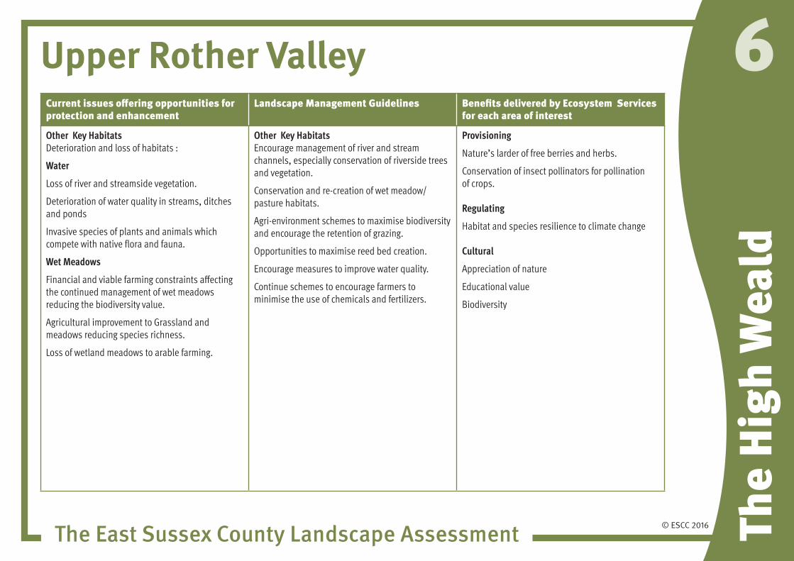
Other Key Habitats Deterioration and loss of habitats :
Water
Loss of river and streamside vegetation.
Deterioration of water quality in streams, ditches and ponds
Invasive species of plants and animals which compete with native flora and fauna.
Wet Meadows
Financial and viable farming constraints affecting the continued management of wet meadows reducing the biodiversity value.
Agricultural improvement to Grassland and meadows reducing species richness.
Loss of wetland meadows to arable farming.
Other Key Habitats Encourage management of river and stream channels, especially conservation of riverside trees and vegetation.
Conservation and re-creation of wet meadow/pasture habitats.
Agri-environment schemes to maximise biodiversity and encourage the retention of grazing.
Opportunities to maximise reed bed creation.
Encourage measures to improve water quality.
Continue schemes to encourage farmers to minimise the use of chemicals and fertilizers.
Provisioning
Nature’s larder of free berries and herbs.
Conservation of insect pollinators for pollination of crops.
Regulating
Habitat and species resilience to climate change
Cultural
Appreciation of nature
Educational value
Biodiversity

© ESCC 2016
Upper Rother Valley
The East Sussex County Landscape Assessment The
High
Wea
ld
6Current issues offering opportunities for protection and enhancement
Landscape Management Guidelines Benefits delivered by Ecosystem Services for each area of interest
Recreation, Green Infrastructure (GI) and ANGS Pressure on bridleways and byways as multi use, including cycling and 4 wheel drives increasing erosion.
Lack of funding to manage and enhance GI for improved access.
Need for better recreational linkages and improved sustainable transport corridors.
Extensive footpath and bridleway network
Need for improved access to natural green space for all users both close to homes and in the wider countryside.
Gentrification
Loss of tranquillity due to more cars and access.
Recreation, Green Infrastructure and ANGSWhere appropriate develop Green Infrastructure Strategies based on a county wide GI mapping.
Plan for and manage recreational pressure on the countryside which could be affected by the increase in population as well as the seasonal holiday makers.
Maximise opportunities for access away from sensitive habitats.
Consider opportunities to create new green corridors and improve existing as safe ideally motorised traffic free recreational routes.
Maximise opportunities for and manage water based recreational activities.
Consider sensitive traffic management on rural lanes.
Provisioning
Protected farmland.
Regulating
Habitat and species resilience to climate change
Water quality and protected aquifers.
Regulating water flow and preventing flooding
Carbon sequestration
Cultural
Recreation
Heritage assets and cultural heritage
Inspirational
Tranquility
Biodiversity

© ESCC 2016
Upper Rother Valley
The East Sussex County Landscape Assessment The
High
Wea
ld
6Current issues offering opportunities for protection and enhancement
Landscape Management Guidelines Benefits delivered by Ecosystem Services for each area of interest
Horse Keeping (‘horsiculture’) and small holdings
Deterioration of the character and quality of the landscape and loss of local distinctiveness.
Loss of historic field pattern where fences replace hedges.
Intensive grazing can cause soil erosion.
Horse Keeping (‘horsiculture’) and small holdingsEnhance the condition of areas of horsiculture and small holdings through the restoration of an intact, well managed hedgerow or ditch network and retaining a diverse grass sward by preventing overgrazing.
Encourage local food production and allotment provision in areas where this will not detract from local landscape character.
Provisioning
Grazing
Food production
Regulating
Habitat and species resilience to climate change
Cultural
Recreation
Heritage assets
Sense of Place and local distinctiveness
Biodiversity

© ESCC 2016
Upper Rother Valley
The East Sussex County Landscape Assessment The
High
Wea
ld
6Current issues offering opportunities for protection and enhancement
Landscape Management Guidelines Benefits delivered by Ecosystem Services for each area of interest
The character of the villages
Gentrification
Urbanisation
Development pressures
Gradual loss and deterioration of heritage features.
Fast traffic on rural lanes
Visitor pressure and cars detracting from local character and distinctiveness of the area in general.
Protect and Enhance the character of the villagesEncourage the production of Neighbourhood Plans which incorporate village design guides.
Plan for new development in the villages to ensure it is designed to a high standard to reflect local character and sense of place.
Establish defined development edges to villages with new tree planting.
Prepare village design guides and tree conservation plans.
Consider traffic management on rural lanes.
Provisioning
Local amenities and facilities.
Regulating
Use of sustainable materials
Habitat and species resilience to climate change
Water quality and protected aquifers.
Regulating water flow and preventing flooding
Cultural
Sense of Place and local distinctiveness
Heritage assets
Biodiversity

© ESCC 2016
Upper Rother Valley
The East Sussex County Landscape Assessment The
High
Wea
ld
6Current issues offering opportunities for protection and enhancement
Landscape Management Guidelines Benefits delivered by Ecosystem Services for each area of interest
Flood management and SUDS schemes?
Flash floods and run off.
Flooding of properties in low lying areas by river and ground water.
Flood management and SUDS schemes?Plan for flood management by conserving and enhancing the flood plains and managing water levels in ditches and drains.
Encourage the design of sensitive flood defence schemes which conserve and enhance the landscape and habitats including river channel restoration schemes
Conserve and enhance existing man made and natural drainage features.
Maximise opportunities for the creation of SUDs schemes which contribute to local amenity and habitat creation.
Provisioning
Water conservation
Regulating
Flood control
Protection of aquifers
Cultural
Heritage assets
Sense of Place and local distinctiveness
Tranquillity
Amenity and recreation
Biodiversity
© ESCC 2016
Upper Rother Valley
The East Sussex County Landscape Assessment The
High
Wea
ld
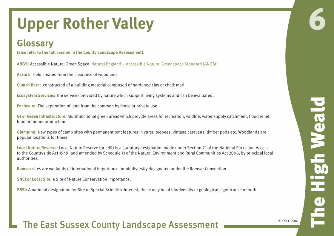
6Glossary (also refer to the full version in the County Landscape Assessment).
ANGS: AccessibleNaturalGreenSpaceNaturalEngland–AccessibleNaturalGreenspaceStandard(ANGSt)
Assart: Field created from the clearance of woodland
Clunch Barn: constructed of a building material composed of hardened clay or chalk marl.
Ecosystem Services:Theservicesprovidedbynaturewhichsupportlivingsystemsandcanbeevaluated.
Enclosure:Theseparationoflandfromthecommonbyfenceorprivateuse. GI or Green Infrastructure:Multifunctionalgreenareaswhichprovideareasforrecreation,wildlife,watersupplycatchment,floodrelief,food or timber production.
Glamping:Newtypesofcampsiteswithpermanenttentfeaturesinyurts,teepees,vintagecaravans,timberpodsetc.Woodlandsarepopular locations for these.
Local Nature Reserve:LocalNatureReserve(orLNR)isastatutorydesignationmadeunderSection21oftheNationalParksandAccesstotheCountrysideAct1949,andamendedbySchedule11oftheNaturalEnvironmentandRuralCommunitiesAct2006,byprincipallocalauthorities.
Ramsar sites are wetlands of international importance for biodiversity designated under the Ramsar Convention.
SNCI or Local Site:aSiteofNatureConservationImportance.
SSSI:AnationaldesignationforSiteofSpecialScientificInterest,thesemaybeofbiodiversityorgeologicalsignificanceorboth.