untitled - agriculture and agri-food canada
TRANSCRIPT


SOILSURVEYOF STORMONTCOUNTY
bY
B. C. MATTHEWS
I and
N. R. RICHARDS
Ontario Agricultural College, Guelph, Ontario
November 1954
REPORT NO. 20 OF THE ONTARIO SOIL SURVEY
Exfierimental Farms Service, Dominion Department of
Agriculture and the Ontario Agricultural College
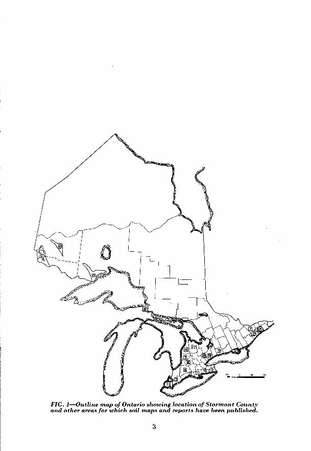
FIG. l-Outline map of Ontario showing location of Stormont County and other areas for which soil maps and reports have been published.
3

ACKNOWLEDGMENTS
The Canada Department of Mines and Technical Surveys, Surveys and Mapping Branch, supplied the base maps. The final copy of the soil map was prepared for lithographing by the Cartographic Section of the Division of Field Husbandry, Soils and Agricultural Engiheering, Central Experimental Farm, Ottawa.
Dr. P. C. Stobbe, Canada Department of Agriculture, assisted with the classification and correlation in the field and critically reviewed the manuscript. Much valuable assistance was provided by Dr. A. Leahey, Canada Depart- ment of Agriculture, during the course of this project.

TABLE OF CONTENTS PAGE
INTRODUCTION......................................................... 7 HOW SOILS ARE CLASSIFIED............................................ 7
Entire Soil Profile is Important. . . . . . . . . . . . . . . . . . . . . . . . . . . . . . 7 Well drained Soil Profiles. . . . . . . . . . . . . . . . . . , . . . . . . . . . . . . 8 Poorly drained Soil Profiles. . . . . . . . . . . . . . . . . . . . . . . . . . . . 10 Soil Type and Soil Series. . . . . . . . . . . . . . . . . . . . . 12
SALIENT FEATURES OF CLIMATE AND SOILS THAT AFFECT Il.4~~ USE IN STORMONT COVNT~.................................................... 13
Parent Materials. ....................................... . 13 Texture ................................................ . 13 Climate ................................................ . 15 Land Use Problems in Stormont County .................... . 15
PART I. GENERAL DESCRIPTION OF STORMONT COUNTY ................. . 19 Location, Area, Farms. .................................. . 19 County Seat and Principal Towns. ........................ . 19 Transportation and Markets. ............................. . 19 Population and Racial Origin. ............................ . 19
PART II FACTORSAFFECTINGTHE FORMATION AND DEVELOPMENTOF STORMONT COUNTY SOILS ................................... . 21
Geology of the Soil Materials. ............................ . 21 Relief .................................................. . 23 Climate. ............................................... . 25 Natural I'egetation ....................................... . 29 Age .................................................... . 29
1?4~T 111. CLASSIFICATION AND DESCRIPTION OF STORMONT COUNTYSOILS ............................................... 30
Summary of the Classification of the Soils of Stormont County. . 30 Description of Stormont County Soils. ....................... 33 Grenville Series. .......................................... 33 Earner Series. ............................................. 34 Matilda Series. ........................................... 35 LyonsSeries .............................................. 36 Wolford Series. ........................................... 37 Morrisburg Series. ......................................... 37 OsnabruckSeries .......................................... 39 KarsSeries ............................................... 39 Uplands Series. ........................................... 41 Rubicon Series. ........................................... 41 Granby Series. ............................................ 43 OsgoodeSeries ............................................ 44 CarpSeries ............................................... 45 North Gower Series ........................................ 46
Belmeade Series. .......................................... 4i ManotickSeries ........................................... 49 Mountain Series. .......................................... 50 Allendale Series. .......................................... 5 1 Marionville Series. ........................................ 51 Farmington Series. ........................................ 52
5

TABLE OF CONTENTS (Cont’d) PAGE
Bottom Land. . . . . . . . . . . . . . . . . . . . . . . . . . . . . . . . 53 Muck.................................................... 53
PART 11'. AGRICULTURE AND LAND USE.................................. 55 Early Settlement and Agricultural Development. . . . . . . . . . . . . 55 Present Agriculture and Land Use. . . . . . . . . . . . . . . . . . . . . . . . 55 Crop Adaptability Ratings and Land Use Management. . . . . . . . 57
APPENDIXES.. . . . . . . . . . . . . . . . . . . . . . . . . . . . . . . . . . . . . . . . . . . . . . . . . . . . . . . . . 70 MAP-Soil Map of Stormont County. . . . . . . . . . in pocket back of report.
TABLES NUMBER
1. Acreages and Salient Characteristics of the Soil Parent Materials. . . . . . . 13 2. Approximate Percentages of Coarse, Medium, and Fine Textured Soils in
Stormont County.. . . . . . . . . . . . . . . . . . . . . . . . . . . . . . . . . . . . . . . . 13 3. Classification of Stormont County Soils According to Natural Drainage. . 15 4. Analysis of Trenton Limestone. . . . . . . . . . . . . . . . . . . . . . . . . . . . . 21 5. Mean Monthly Temperature for Selected Points.. . . . . . . . . . . . . . . 28 6. Mean Monthly Rainfall in Inches for Selected Points. . . . . . . . . . . . . . . . . . 28 7. Stormont County Soils Grouped According to Texture, Parent Materials
andDraillage................................................. 32 8. Utilization of Occupied Land According to Township (1941 Census) . . . . . 56 9. Acreage of Different Crops According to Township (1941 Census). . . . . . 57
IO. Number of Livestock Population According to Township (1941 Census) . . 57 11. Crop Adaptability Ratings for Good cropland. . . . . . . . . . . . . . . . 60 12. Crop Adaptabilit,y Ratings for Good to Fair Cropland. . . . . . . . . . . . . . . . 62 13. Crop Adaptability Ratings for Fair Cropland. . . . . . . . . . . . . . . . . . 62 14. Crop Adaptabilit,y Ratings for Fair to Poor Cropland. . . . . . . . . . 64 15. Crop Adaptability Ratings for Poor Cropland. . . . . . . . . . . . . . . . . . . . . 65 16. Crop Adaptability Ratings for Submarginal Cropland.. . . . . . . . . . . . . . . 66 17. Summary of Crop Adaptability Groups with Acreages and Chief
Limitations. . . . . . . . . . . . . . . . . . . . . . . . . . . . . . . . . . . . . . . . . . . . . 67 18. Crop Adaptability Ratings for Selected Crops for the Soil Types of
Stormont County, Ontario.. . . . . . . . . . . . . . . . . . . . , . 68
FIGURES 1. Outline Map of Ontario showing location of Stormont County and other
areas for which soil reports have been published. . . . . . . . . . . . . . . . . . . 2 2. Relationship Between the Well Drained Great Soil Groups in Stormont
County....................................................... 9 3. Relationship Among the Soils Profiles of a Catena . . . . . . . , . . . . . . , . . . . . 12 -1. Soil Problem Areas in Stormont County. . . . . . . . . . . . . . . . . . . . . . . 14 5. Natural Drainage of Soils of Stormont County. . . . . . . . . . . . . . . . . . . . 16 6. Townships, Principal Centres, and Railways in Stormont County. . . . . . . . 18 7. Redrock Geology of Stormont County.. . . . . . . . . . . . . . . . . . . . . . . . . . . 22 8. Physiographic Divisions of Stormont County. . . . . . . . . . . . . . . . . . . 24 9. Natural Drainage Courses in Stormont County.. . . . . . . . . . . . . . . . . . . . . 26
IO. Areas and Distribution of Soils of Different Crop Adaptability Groups in Stormont County.. . . . . . . . . . . . . . . . . . . . . . . . . . . . . . 58
G

Soil Survey of Stormont County bY
B. C. MATTHEW and N. R. RICHARDSI
INTRODUCTION
The primary purpose of a soil survey is the classification and description of the soils of an area. Such features as colour, structure, texture, depth, and number of horizons as well as some chemical characteristics are described for the different soils. Finally, some recommendations for land use are suggested. In seeking information regarding the soils of the area, reference should be made to the map as well as to the report. THE M.kP-The map presents all the important features of the County such as cities, towns, railways, roads, post offices, lakes and rivers as well as the soils information. The different soil areas are delineated by solid black boundary lines and the soil type is identified on the map by the use of colours, letter combinations, and symbols, the key for which appears at the bottom of the map as well as in t,he report itself. In studying the map, it must be kept in mind that the scale of the map prohibits the presentation of sufficient detail to show variations of very small acreages (i.e. less than twenty-five acres). However, the map and report when properly used can furnish information of valuable assistance in estimating the productivity of the soil even in rather limited areas. THE REPORT-The report is divided into several sections as listed in the table of contents. Several tables of statistics in the text and, in the appendix, a t)able of physical and chemical analyses of samples of surface soils are presented to support statements made in the text of the report.
HOW SOILS ARE CLASSIFIED
The development of a soil from unweathered broken rock is an intriguing story. I-nder the influence of the vegetation, &mate, and drainage acting on the raw soil material, called parent material, different soil layers develop over a period of time. Accordingly in a vertical cut through the soil, two or more layers or horizons may be observed above the grey parent material. The different soil horizons from the surface down to the parent material make up the soil profile.
Entire Soil Profile is Important The entire soil profile must be considered in estimating the productivity of a
given soil. Two soils, for instance, may have similar surface layers but one may have a compact subsoil that restricts water movement and root penetration while the other may have an open porous subsoil that permits rapid water movement and easy root penetration.
In classifying soils, therefore, the entire soil profile is considered. In Stormont County, twenty-six different soils have been recognized and delineated on the map. These soils differ from one another in one or more of the following features of the soil profile: number, colour, thickness, structure, and chemical composition of t,he different horizons.
1 Head, Department of Soils, Ontario Agricultural College, formerly Senior mental Farms Service.
Pedologist , Experi-
7
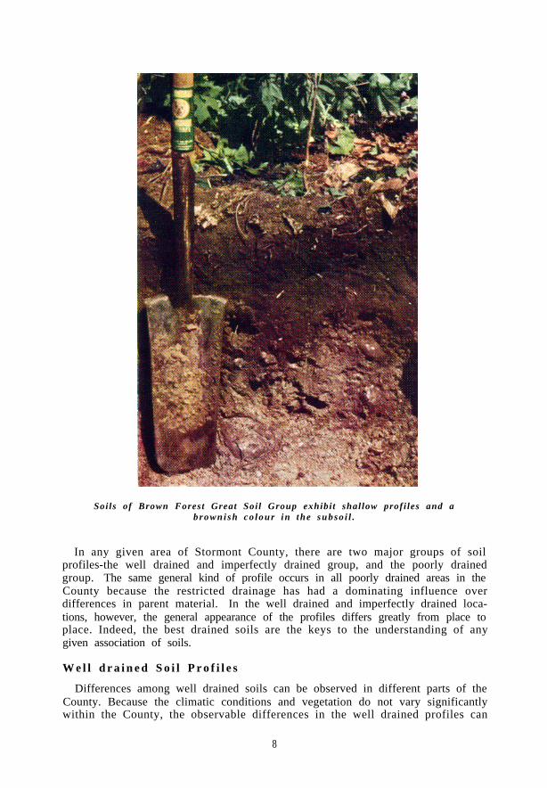
Soils of Brown Forest Great Soil Group exhibit shallow profi les and abrowni sh co lour in the subso i l .
In any given area of Stormont County, there are two major groups of soilprofiles-the well drained and imperfectly drained group, and the poorly drainedgroup. The same general kind of profile occurs in all poorly drained areas in theCounty because the restricted drainage has had a dominating influence overdifferences in parent material. In the well drained and imperfectly drained loca-tions, however, the general appearance of the profiles differs greatly from place toplace. Indeed, the best drained soils are the keys to the understanding of anygiven association of soils.
W e l l d r a i n e d S o i l P r o f i l e s
Differences among well drained soils can be observed in different parts of theCounty. Because the climatic conditions and vegetation do not vary significantlywithin the County, the observable differences in the well drained profiles can
8

usually be related to the parent materials, especially to the lime content. In Stormont County, there are three great groups of well drained profiles, namely Brown Forest, Grey-Brown Podzolic, and Podzol.
The differences among the three groups of profiles may be explained on the basis of age of the soil and the progressive loss of lime from the soil materials. Figure 2 shows the probable relationship between the three Great Soil Groups and indicates (1) the course of soil profile development as lime is lost in time, or (2) the differences in profiles resulting from different original lime contents of the parent materials.
The following is a description of a soil profile that represents the Brown Forest Great Soil Group in Stormont County*.
A0 - x-0 inches of matted leaf litter. A1 - O-5 inches of very dark grey loam; friable consis-
tency; medium crumb structure; few stones; medium
* For chemical analyses of a Brown Forest soil profile see Appendix Table 2.
Depth in
Inches
0
12
24
36
48
FIG. %-Relationships
Brown Forest Soils Grey Brown Podsolic Soils Podzol Soi Is
d-l PH PH
\
\
\ c
\
\ Parent Material \ \
\ \ \ \
\ \
8.0 7.2 \ ‘\
\ ‘, \ .
Loss Of Lime In Time >
Decreasing Original Lime Content 3
between the well drained Stormont County.
soil groups in

to high in organic matter; free carbonates may be present; pH-7.0. 5-10 inches of grey-brown loam; friable consistency; fine nuciform structure; few stones, free carbonates; pH-7.0.
lo-18 inches of very dark grey-brown loam; friable consistency ; medium nuciform structure ; stones and boulders; free carbonates; pH-7.2.
18-23 inches of grey-brown loam; friable consistency; very weak fine nuciform structure; stony; calcareous; pH-7.6. Grey or grey-brown loamy calcareous till; stony; somewhat compacted ; pH--8.0.
-
On a well drained site, where lime has been partially lost from the soil material (or where the material had only a medium lime content originally), the kind of profile that commonly occurs belongs to the Grey-Brown Podzolic Great Soil Group. The Kars gravelly sandy loam as described below is a good example of such a soil:
A0 - s-0 inches of leaf litter.
-iI - O-4 inches of dark grey-brown sandy loam; very fine crumb to single grained structure; few stones; pH-6.8.
AZ - 4-12 inches of yellow-brown sandy loam; single grained structure; few stones; pH-6.7.
B - 12-20 inches of dark brown loam or sandy loam; small nuc’iform structure; few stones; pH-7.0.
C - Rough unsorted gravel and sand; low in carbonates; stony; some boulders; pH-7.0.
111 well drained positions on materials that were originally low in lime or are so open in texture that leaching has rapidly removed the lime, a profile representa- tive of the Podzol Great Soil Group has developed. The follo_;ring is a description of a profile showing the characteristics of the Podzol group in Stormont County:
A, - 1-O inch of litter of twigs and needles.
A2 - O-2 inches of grey sand ; extremely friable consistency; single grain structure; pH-5.8.
B2 - 2-15 inches of dark brown sand; friable consistency; single grain to very fine nuciform structure; pH--6.4.
C1 - 15-22 inches of brownish yellow sand; friable COII-
sistency; single grain structure; pH-6.4.
CZ - Grey sand and gravel; non-calcareous; pH-6.6.
Poorly drained Soil Profiles For each well drained profile there is a drainage association of three profiles
representing three drainage conditions which are usually related to topography. The two best drained members are named in terms of one of the profiles described above. The poorly drained member, however, has a completely different set of horizons and is called a “glei soil”.
10

Commonly, the restricted drainage has far outweighed all other factors of soildevelopment so that the same general kind of profile occurs in the poorly drainedlocations throughout the County. The poorly drained profiles of Stormont Countyare classified in the Dark Grey Gleisolic Great Soil Group. A description of aDark Grey Gleisolic soil profile found in the County is presented below:
A0—½-0 inches of matted leaf litter.A1—0-6 inches of very dark brown clay; friable con-
sistency; crumb structure; high in organic matterwhich is well incorporated with the mineral fraction;no free carbonates; pH—6.8.
G1—6-10 inches of grey clay; mottled with rusty brown;plastic consistency ; massive structure ; pH—7.0.
G2—l0-30 inches of mottled rusty brown and grey clay;extremely plastic ; massive or very coarse blocky
Note profi le characterist ics of a Dark Grey Gleisol ic Soil–Surface soi li s d a r k g r e y c o l o u r ; s u b s o i l a d r a b g r e y w i t h r e d d i s h b r o w n m o t t l i n g .

Deptl
in
Inch@
24
36
48
Drainage Profiles
Well Drained I Imperfectly Drained
3rown Forest Soils I Brown Forest Soils
Grey Brown Grey Brown
Poorly Drained I
Dark Grey&?&sisolic 1
Black
1
Hatbrial + . \I,.\‘\)’
----- hver Limit Of Rust Mottling
FIG. S-Relationships among th,e soil pro$les of a Catena.
struchure; no free carbonates; pH-7.2. C - Grey clay; massive; plastic; pH-7.2.
The mottling that is evident in the “G” (glei) horizon is indicative of a fluctua- ting water table and the consequent alternat,e oxidation and reduction of the iron.
The differences in soils that are due to differences in drainage are usually observ- able within field or farm boundaries. Figure 3 shows the drainage associates of the Brown Forest soils and represents the kinds of profiles commonly found in sequence down a slope. Because of the fact that well drained, imperfectly drained, and poorly drained soils occur in close geographical association, it is convenient to use the term “catena” to designate two or more soil series developed on similar parent material but differing in drainage.
Soil Type and Soil Series The principal unit of soil mapping is the soil type. The soil type consists of a
group of soils with profiles having similar genetic horizons, developed from similar parent material.
In using the map, it is important to keep in mind that a given soil type may include a limited range in properties. The boundaries between soil types vary in sharpness. Between two soil types in the field there is a zone that includes some of the features of each type. Also within a given type, there are often discrete areas of other types too small to be shown on the soil map.
12

Soil types do not occur at random, nor is their nature a matter of chance. The factors that have determined soil type differences in Stormont County are discussed in Part II. If one knows the conditions under which a given soil type has developed, he will be able to obtain from the soil map a picture not only of the present character of the soil but also of the slope of the area where it occurs, the native vegetat,ion, drainage, and other factors that have affected its formation.
Two or more soil types developed on similar parent material, under similar drainage conditions, but differing in texture of the surface horizon are grouped together as a Soil Series.
In certain instances, soil of a certain type or series may possess certain features that limit its agricultural value; hence phases of a soil type or soil series are map- ped. For example, a physical characteristic such as stoniness or topography may drastically change the agricultural value of a soil without altering the profile characteristics sufficiently to place it in another soil type; hence phases of soil types have been mapped to delineate areas that have special problems for agricul- tural use.
SALIENT FEATURES OF CLIMATE AND SOILS THAT AFFECT LAND USE IN STORMONT COUNTY
A soil survey provides the only sound basis for any programme for improved land use and soil conservation. It is only with a clear broad understanding of a problem that any progress can be made toward its solution. All of the important factors of climate and soil are discussed later in the report. A brief resumh of these factors in relation to crop productiorl is presented here as an introduction to the soils of Stormont County.
Parent Materials The effect of parent material on the type of soil developed is discussed in Part
II. Parent material is a fixed factor which the farmer cannot alter. Hence it is an important factor in determining the agricultural value of a land area.
TABLE 1 ACREAGES AND SALIENT CHARACTERISTICS OF THE SOIL
PARENT MATERIALS
PARENT MATERIAL Glacial till
y0 TOTAL ACREAGE ACREAGE 114,900 45.0
Glacio-fluvial material 19,100 7.4
Outwash material 37,400 14.2 Lacustrine material 37,200 14.1
Organic 35,100 13.3 Alluvial 15,700 6.0
SALIENT CHARACTERISTICS OF SOIL
Medium fertility; tendency to be stony; some erosion susceptibility. Coarse texture; medium to low fertility; stony; subject to erosion. Coarse texture; low to medium fertility. Medium to fine texture; inadequate drainage; stonefree. Deep organic surface; poor drainage. Flood land along stream courses of variable texture and fertility.
The economy of production depends on the extent to which the farmer can adapt his cropping practices to the natural capabilities of his soil. Fortunately a large portion of Stormont County is till material that develops a good soil for
13

SOIL PROBLEM AREAS
ml Drainage and Fertility
Compact, Stony Subsoil
III \ ‘\ ’ Stoniness and Erosion
L&d El A~* Submarginal Cropland
FIG. P-Soil problem areas in Stormont County.
14
general farming which stresses dairying for replenishment of organic matter. This also creates a need for pasture which controls erosion on the slopes.
Texture There is a wide variation in texture of the surface soils of the County. For the
purpose of this discussion the soils may be grouped into three groups as in Table 2.
TABLE 2 APPROXIMATE PERCENTAGES OF COARSE, MEDIUM AND FINE
TEXTURED SOILS IN STORMONT COUNTY
TEXTI~RE yO TOTAL AREA Coarse 21.4 Medium 33.8 Fine 24.0
Soils of coarse texture usually contain fewer plant nutrients originally and they are less capable of holding nutrients than the fine textured soils. The open structure of the sandy soils promotes relatively rapid destruction of organic matter which must be constantly renewed.
The medium and fine textured soils have a relatively high fertility level but the latter tend to be inadequately drained.
Climate The climate of Stormont Count,y is suitable for general farm crops. The temper-
ature is usually too low in the winter months for the survival of winter wheat. However, the temperature and t)he amount and distribution of rainfall are usually adequate for the economical production of many common crops.
The three factors mentioned above cannot be altered by the farmer to suit his crop needs. However, there are several factors concerning the soil which can be altered; these, as described in following paragraphs, require special attention in order to make the best possible use of the land.
Land Use Problems in Stormont County No one knows the peculiarities of a particular parcel of land better than the man
who is concerned with making a living from it. The knowledge of soil management, in many instances, has been built up through generations by the system of trial and error. Soil scientists are now seeking to learn which management practices are good and why new ones should be adopted in some instances. This section is concerned with the mutable factors of the soil with no regard for factors foreign to the soil such as disease, economics, and weather. &MINAGE--This is a factor in soil productivity that is of great importance in Stormont County. Approximately 40% of the soils in the area have a drainage problem to some degree. One half of this area, however, consists of very poorly drained soils which are costly to reclaim for general farming. The remainder consists of fine textured lacustrine materials of high fertility. The natural drainage varies from fair to poor. Because of the comparatively impervious subsoil, the internal movement of water is slow even on those areas with a low water table. More open ditches should be installed and existing ones should be kept clean. Increased use of tile drainage should prove economical. The growth of deep rooted crops will improve those soils where inadequate drainage is a result of an impervious
15

NATURAL DRAINAGE
. . . . . . . .
El :* . . . . . . . . . . . . . . . . :a.. . . . . : Good
VA Fair
h\V Poor
ITI Very Poor
FIG. 5-ATatural drainage of soils in Stormont County.
16

subsoil. There is a need for investigational work to determine the most effective means of overcoming the drainage problem in Stormont County to improve the reliability and versatility of the soils.
TABLE 3
CLASSIFICATION OF STORMONT COUNTY SOILS ACCORDING TO NATURAL DRAINAGE
DRAINAGE CLASS Well drained
Imperfectly drained
Poorly drained
Very poorly drained
SOIL SERIES Wolford Earner Grenville Manotick Uplands Kars E;;;i;w
Rubicon Mountain Carp Lyons Osnabruck Granby Allendale North Gower Marionville Osgoode Belmeade Muck Bottom Land
k!REAGE yO OF TOTAL 112,200 42.8
43,900 16.7
53,800 20.5
52,300 20.0
Table 3 indicates that more than forty per cent of Stormont County is well drained. When these soils are interspersed with the inadequately drained soils, the latter become of greater value in producing pasture while the former soils produce the cereal grains. As a number of farms, however, have no well drained soils, drainage is an important problem.
FERTILITY-The natural fertility of the soils of Stormont County is medium. The fine textured soils are relatively higher in plant nutrients than the coarse textured soils. The fact that the coarse textured soils tend to be better drained and hence more highly cultivated has intensified their lack of fertility. Because organic matter oxidation and removal is rapid, constant addition of commercial fertilisers and barnyard manure is necessary for continued crop production.
The till soils which have a high lime content usually respond to phosphatic fertilizers. For certain crops, commercial nitrogen and potash may be beneficial.
The fine textured soils are usually well supplied with plant nutrients, phosphorus being particularly high when compared to similar soils in Western Ontario.
The most satisfactory beginning for any fertilizer programme is to obtain soil tests of individual fields as a basis for fertiliser recommendations. Facilities for such tests are provided at the Kemptville Agricultural School.
I)RAINAGE AND FERTILITY-SOme soils present a combination of drainage and fertility deficiencies. Coarse textured soils on level to depressional topography present a grave problem in land use. Usually the organic matter content is ade- quate in the natural state, but when drainage is improved and cultivation is begun the organic matter is lost rapidly. Hence, the fertility is depleted after a few years. Extreme care must be exercised in the utilization of such soils and even under the
17

DUNDAS
COUNTY
Qso 00 c
\
RUSSELL COUNTY
OSNABR CK y’
COUNTY
1 GLENGARRY
t HARRISON CORS. CORNWALL
ST. . ANDREWS
WEST
FIG. t+Townships, Principal centres and Railways in Stormont County.
18

best known soil management agricultural soils.
practices they never become better than mediocre
Stoniness and Erosion The problem of stoniness is a physical one which is especially important in the
south eastern part of the County. In many instances, the stones occur on soil types that otherwise would be good agricultural land. It is difficult to make a general statement as to the advisability of stone removal. The cost, of removing the stones must be charged against the resulting increase in returns. Parts of the area have been cleared of stones and are producing good crops. Even if the stones are not removed, the land can usually be used for permanent pasture product)ion.
The topography of Cornwall Township is rolling and as a result there are several slopes where erosion is a hazard. Care must be exercised in farming these soils. Contour cultivation and strip cropping may be advisable on some farms.
Submarginal Cropland Approximately 20 per cent of the land area of Stormont County consists of
slrbmarginal cropland. The bottom land along stream courses is generally devoted to permanent pasture and is especially valuable for this purpose during dry summer months. The major part of the submarginal land is muck. Muck soils are not delreloped agriculturally in the County. The distance to larger centres of popula- tioli minimizes the value of the muck land for the production of truck crops.
Only a very small part of the Count,y has no serious land use problem. Even in these areas, however, the farmer must exercise good management practices to protect his soil. Whenever man upsets the balance of nature by growing cultivated crops, he must proceed with caution.
19

PART I
GENERAL DESCRIPTION OF STORMONT COUNTY
Location, Area, Farms
The St. Lawrence River flows along the southern boundary of Stormont County; Dundas and Glengarry Counties border the west and east sides respectively; and adjoining to the north are Russell and Prescott Counties. From the city of Ottawa the nearest part of Stormont County is approximately 40 miles, while Montreal lies about 75 miles away from the southeast corner of the County.
The area of this Eastern Ontario County is approximately 263,680 acres (1941 Census) of which 238,208 acres are listed as occupied land. The remainder of the total area is taken up by roads, railways, and rivers. According to the 1941 Census of the Dominion of Canada, there are 2,215 farms in the County with an average area of 100 acres per farm. About 8% of the area of Stormont County still retains its native forest vegetation.
County Seat and Principal Towns
Cornwall, located on the banks of the St. Lawrence River, is the County seat and is the largest centre in the area, having a population of approximately 14,100. This bustling city has at least two important industries and is a well known port for the ships that ply the Great Lakes System. The Roosevelt International Bridge joins Cornwall and the surrounding area to New York State immediately across the river.
There are a few villages scattered throughout the County. Finch with a popula- tion of about 400 is the largest of these; Avonmore, Moose Creek, Newington, Monckland, Aultsville, Wales, and others are of lesser size.
Transportation and Markets
Stormont County is well supplied with transportation facilities. The main line of the Canadian National Railway traverses the southern part of the County closely paralleling the St. Lawrence River. The Canadian Pacific Railway from Toronto to Montreal runs across the central part of the County while the New York Cent)ral Railway from Ottawa to New York traverses the area from north to south to cross the St. Lawrence River via the international bridge. In addition to t)he railroads, there is a good network of roads throughout the County. No. 2 Highway traverses the County along the banks of the St. Lawrence River and three well kept County roads run northward from the highway. The Township roads are kept in a reasonably good state of repair.
The main markets for the agricultural products of Stormont County are at Montreal and Ottawa, In recent years, there has been considerable movement of dairy cattle to the United States as well. Transportation facilities are adequate for the rapid and efficient movement of goods to market.
Population and Racial Origin
According to the 1941 Census the total population of Stormont County is 40,905 or 1 .I% of the total population of Ontario. Classed as rural dwellers are 26,391 persons or 64.5y0 of the population while there are 14,514 urban dwellers, 14,117 of whom live in the city of Cornwall.
There are about equal numbers of people of British and French origins in the
20

County along with a small number of people of other origins and a few Indians on the I ndian Reserve.
TOTAL POPULATION....... Canadians of British Origin.
English. Irish. Scotch. Others L .
Canadians of French Ori&: Canadians of Netherlands Origin. Canadians of Indian Origin. Canadians of Other Origins.
40,905 17,762 5,422 5,270 6,969
101 18,56i 2,881
466 1,229
21

PART II
FACTORS AFFECTING THE FORMATION AND DEVELOPMENT OF STORMONT COUNTY SOILS
A knowledge of the soils of any area requires a knowledge of the fact,ors that cause soil differences and that are responsible for the various soil conditions. The more important of these factors are: (1) soil parent material, which determines the kind of material from which the soil has developed; (2) relief, which includes the surface features of the land, t,he drainage conditions, etc; (3) climate, which influences the kind and intensity of weathering and leaching of the soil material; (4) vegetat,ion which affects the content of organic matter in the soil; (5) soil age or length of time weathering forces have acted. In any given location, all the factors are operative but usually one factor is dominant over the others. Thus it is that the character of some soils is mainly determined by the character of the material from which they are derived, while at other places parent material is of minor influence and the properties of the soils are to a large extent governed by condi- t ions of relief.
-4 knowledge of the factors affecting soil formation will add greatly to our understanding of the soils in Stormont County.
Geology of the Soil Materials This part of North America was subject to af’ least three glaciations. However,
only the surface deposits or those of the last (Wisconsin) glaciation influence the soils of Stormont County.
The movement of the ice was generally in a north-south direction although in the southern part of the County the drumlins (elongated rounded ridges) roughly parallel the St. Lawrence River valley, indicating that the ice advanced locally from the northeasterly direction. Following the recession of the ice, an arm of the sea, named Gilbert Gulf, entered this area. During this period many of the fine particles were washed from the ridges leaving the boulders. As the ice retreated farther the land commenced to rise and eventually came above sea-level.
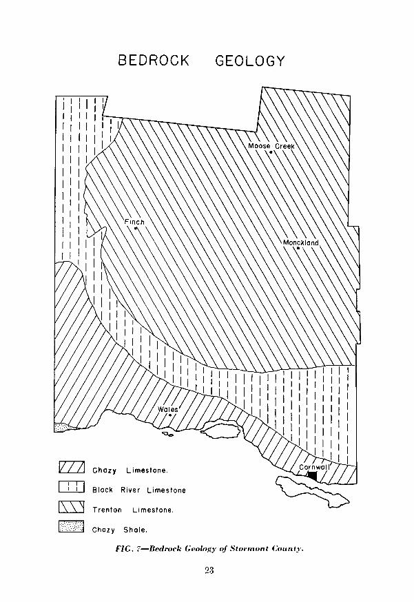
Most of Stormont County is underlain by Trenton limestone with some Black River and Chazy limestone in the southern part. The Trenton limestone is readily broken up and, therefore, is generally covered with a good depth of till. There is very little rock outcrop in the County.
A more complete report on the physiography of the area has been written by Chapman and Putnam*.
Although the soil materials have been transported, they do bear some relation to the surface rock formation. The Trenton limestone is dominantly calcium carbonate but has a rather high percentage of insoluble matter as shown in table 4.
The dominant chemical characteristics of the underlying bedrock is reflected in the soils which have a high content of calcium carbonate.
Another factor that affects the soil parent materials is the mode of deposition Mat)erials of two general groups occur in Stormont County: (1) unsorted tills laid down by ice, (2) sorted clays, silts, sands and gravels deposited by water. The tills are further differentiated on the basis of size and kind of stones and the killd of fine material between them. The water-laid materials are grouped according to the size of the particles.
*Chapman, L. J. & Putnam, D. F., The Physiography of Eastern Ontario, Soi. Agr. 20:7, 1940.
22

After the ice sheet disappeared from the area a deposit of till of varying depth remained over the Trenton limestone bedrock. Much of the till was left arranged in the form of long oval shaped hills (drumlins) whose long axis is roughly parallel to the direction of movement of the glacier. Soils developed on till are generally good agricultural soils characterized by rolling topography, with some stones throughout t)he profile.
TABLE 4 ANALYSIS OF TRENTON LIMESTONE**
Insoluble mineral matter. 6.4101, Ferric oxide. 0. 560j0 Alumina. . 0.24% Calciumcarbonate.‘:..‘.:.:. .‘:. 1. . ..I. .., 89.59% Magnesium carbonate. : 3.80%
TOTAL.. . . . . . . . ..lOO.SO% (Sample taken from old quarry 2 miles south of Apple Hill, Glengarry County.)
-4 large portion of the area consists of water-laid mat)erial, an indirect result of glaciation. During the recession of the ice, meltwaters rushed in streams through crevasses in the ice and deposited coarse gravel and sand that remain today as long narrow ridges called “eskers”. These ridges provide a good source of road gra\rel.
Extensive areas of medium sand materials also occur. Such material was deposited by mo\rillg water as it slowed down and flowed out over the area in front of the glacier. The topography is usually level to slightly undulating. As the ice receded a11d the waters of Gilbert Gulf and Champlain Sea co\Tered the area much sedi- ment was formed in the depths of these post-glacial waters. The sediment is fine textured, stonefree, and calcareous. It is less alkaline than the till and generally is illadequately drailled, partly because of its level topography.
I. Till Deposits The till deposits are made up of stones, dominantly limestone with some sandstone
alld Precambrain rocks, ranging in size from very fine grit to large boulders scat- tered throughout a matrix of sand, silt, and clay in varying proportions. The till area is characterized by drumlins particularly in the southeastern portion of the County where the topography is strongly undulating to rolling. The southern part of Stormont County lies in a lowland that was submerged by the glacial Champlain Sea. The stony crests of the drumlins and ridges are a result of the removal of fine materials from the crestIs t)o the valleys during the submergence. The water-laid materials among the t,ill deposit,s range in texture from clay to I-erv fine sand with a few deposits of gravel in close association with the till areas.
II. Gravelly Deposits The gravelly ridges are located for the most part on the height of land that
separates the South Nation River watershed from that of the Raisin River. The ridges consist of rough sorted gravel and coarse sand dominated by limestone fragments with some rocks of Precambrian origin.
III. Deposits of Water-laid Sediments Water-laid sediments range in texture from sand to clay and are typically
st onefree.
**Preliminary Report on the Limestones of Quebec and Ontario, Goudge, M. F. Canada, Department of Mines and Resources.
24

PHYSIOGRAPHIC DIVISIONS
ml Medium Textured TIII Plains
:; . . :. . . . El .,. .::::: :.,:*.*.e... Fluwo-glacial Ridges
Muck Plains
m Deltaic Sand Plains
IT--l Deltalc Fine Sand, Loam and Silt Loam Plains.
I/// Locustrine Clay Loam Plains
FIG. 8-Physiographic Divisions of Stormont County.
25

(a) Coarse textured material There is only a limited area of sand plains in Stormont County and they are associated with the gravelly ridges. The topography is level to strongly undulating. Stjones are found occasionally on the surface but do not occur within the profile. The parent material is coarse sand that is often water- logged because of a compacted subsoil or underlying heavy textured materials. The lime content and general fertility of the sand plains are low.
(1,) Medium textured materials Plains of medium textured materials occur in close association with the till plains. These water-laid materials apparently have been washed down from the till areas and have a variable composition indicating that they have been derived from several different kinds of rocks.
The topography of these plains is level but is broken by the till deposits that give an undulating effect to the general relief.
(c) Fine t ext)ured materials The largest area of clay materials is situated along the South Nation River in the northwest portion of the County. It represents an extension of the much larger clay plain in Dundas County. The subsoil is a grey and rusty mottled clay or silty clay that requires artificial drainage for maximum crop production. There are local areas in the clay plain west of Moose Creek ill which the parent materials are banded pink and grey clay similar to the Hearbrook series mapped in Russell County.
IV. Muck Deposits The surface layer of the muck deposit)s is largely of organic origin, the material
being in various stages of decomposition. In most instances, the muck is support’ing a scrub willow vegetation. The material underlying the muck deposits is commonly clay although grey sand or loamy till may be found in some areas.
Relief The relief of Stormont County is variable. The southeastern part is strongl)
uiidulating to rolling. The western portion is undulating to level while the north- eastern sandy areas are moderately undulating.
There is a height of land running in a northeasterly direction through the central part of the County. Land to the north of this divide is drained by the South Xation River and its tributaries. Immediately south of t.he divide, the Raisin River has its source near n’ewington in Osnabruck Township. This river flows in an easterly direction approximately parallel to the St. Lawrence River. The extreme southern portion of the County is drained into the St. Lawrence River by small creeks that have their source within five miles of the river.
The elelration is seldom higher than 325 feet above sea-level and the average is about 225 feet. The channel of the South Nation River is shallow and, hence, there is some danger of spring flooding. The Raisin River on the other hand has a relatively deep channel and floods only a limited area of lowland during periods of high raiiifall.
There are numerous depressional areas in which muck has accumulated, and, illdeed, is still accumulatiiig.
The surface drainage is facilitated by the large number of streams and creeks throughout the area. The internal drainage is influenced by relief and also texture and structure. Hence movement of water within the heavy soils is usually slow.

c
FIG. 9-Natural drainage courses in Stormont County.
27

The medium textured soils that are strongly undulating to rolling have goodinternal and external drainage.
C l i m a t eStormont County is in the Eastern Ontario climatic region of Southern Ontario
as classified by Putnam and Chapman.* The mean annual temperature is 42° ascompared with 44º at Guelph, 45.3° at Rrantford and 32º at Kapuskasing. Theextreme low temperature recorded for the area is -44° while the extreme high is104° giving a range of 144°. The average date of the last frost in the spring isMay 11-24 with 130 to 140 days in the frost-free period. The average length ofthe growing season is 191 to 197 days.
The precipitation varies from 34-40 inches annually. About 17-18 inches ofrain fall during June, July and August, an amount, which is usually adequate folmost, farm crops. Drought frequency is low.
*Putnam, D.F. and Chapman, L.J., The Climate of Southern Ontario, Sci. ,Agr. 18:8, April 1938.
P o s t - g l a c i a l l a k e w a t e r s h a v e r e m o v e d t h e f i n e r p a r t i c l e s f r o m t h etops of some ridges leaving a large number of boulders on the surface.
28

TABLE 5 MEAN MONTHLY TEMPERATURE FOR SELECTED POINTS
(Temperature in degrees Fahrenheit)
1 /
/PERIOD OF JAY RECORD A ’
Ottawa .......... , 52 I 11.8 Brockville. ’ ...... 22 ; 18 Morrisburg. ...... i 24 Pembroke.
/ 15.6 1 ...... 44
Guelph ....... 1 55 ki
FEB. MAR. APR.
12.7 18 15.2 14 19
24.7 30 26.8
2
41.4 43 40.0 41 54 64 42 j 53
/ 63
MAY JUNE JVLY AUG. SEPT. OCT. Nov. DEC. YEAR
54.9 64.6
gi.8 65 62.4
68.9
z2 69’ 68
66.3 68 64.9 66 66
---(---
58.5 46.2 60 49 62.7 46.6
ii 46 47
TABLE 6 MEAN MONTHLY RAINFALL IN INCHES FOR SELECTED POINTS
32.4
E.3
xi
17.3 22 19.9
ai
41.6 45 42.4 42 44
lp~~~“~ JAN. 1 FEB. ~ MAR. 1 APR. ~ MAY PERIODOF JAN RECORD . FEB. MAR. APR.
I ~ MAY JIiNE JULY AUG. SEPT. OCT. Nov. DEC. YEAR ! JIiNE / JULY 1 AUG. I SEPT. 1 OCT. 1 Nov. 1 DEC. 1 YEAR
---- _---~---- __- _ __-__ -~-- -~- I
2.98 2.98 2.40 2.40 2.65 2.65 2.32 2.32 ’ ’ Ottawa. Ottawa. . ......... E E
/ / 2.74 274 3:22
3.39 3.39 3.6'7 3.6'7 3.00 3.00 2.94 2.94 2.68 2.68 2.63 2.63 2.84 2.84 34.24 Morrisburg. Morrisburg. . ...... 3.69 3.69 2.97 2.97 3.09 3.09 3.28 3.28 3.22 3.20 3.20 3.12 3.12 3.34 3.34 2.85 2.85 3.42 3.42 3.35 3.35 3.09 3.09 38.60 Pembroke. Pembroke. ...... 44 44 2.31 2.31 1.96 1.96 2.25 2.25 2.19 2.19 ’ ’
/ / 2.92 2.92 3.26 3.26 3.50 3.50 2.86 2.86 3.52 3.52 2.96 2.96 3.15 3.15 2.53 2.53 33.41
Guelph Guelph.. . . ......... 55 55 2.35 2.35 l.i9 l.i9 1.88 1.88 2.30 2.30 2.80 2.80 2.89 2.89 3.24 3.24 2.87 2.87 2.67 2.67 2.39 2.39 2.48 2.48 1.99 1.99 29.65
34.24 38.60 33.41 29.65

Natural Vegetation During the time that it 1s becoming established, vegetation is dependent on
climate and soil conditions. However, when it is established, vegetation exerts a strong influence on the type of soil developed. The types of litter found under coniferous and deciduous forests are quite different in chemical composition, consistency, and ease of decomposition.
It is impossible to determine which features of the soils of Stormont County have been influenced by vegetation only, because all the other soil forming factors have been operating simultaneously. Indeed, it is difficult to determine the native vegetation on certain soil types because only about eight per cent of the area is wooded under present land use. Certain associations of trees, however, have been observed to occur on certain soil areas more often than others.
The Kpper St. Lawrence Section of the Great Lakes-St. Lawrence Forest Region as described by Halliday* includes the County of Stormont.
The general character of the tree cover is broad leaved but there is a fair rep- resentation of coniferous growth. The dominant association on well drained sites is sugar maple and beech with small numbers of birch, ash, and elm. Hemlock, white spruce and pine occur on the light soils. In poorly drained areas elm dominates along with tamarack, white cedar and black ash. Clumps of cedar are character- istic of stony sites.
Age The number of features that are developed in a soil and their intensity depend
to some extent on the length of time that the soil forming factors have been active. Hence, time itself becomes a soil forming factor.
Stormont County is in the area that was covered by ice during the glacial period. When the ice retreated the Champlain Sea submerged the area with marine waters. According to Antevs* the Champlain Sea receded about 6-10,000 years ago. Since that time, the soils of today have been developed.
*Halliday, IV. E. D., A Forest Classification of Canada, Forest Service Bulletin, No. 89. *Antevs, Ii‘,. Late Quaternayv ITpwarpings of Northeastern North America, Jour. of Geol. 37, 1930.
30

PART III
CLASSIFICATION AND DESCRIPTION OF STORMONT COUNTY SOILS
Although knowledge of the factors that have affected the development of the soils of Stormont County is interesting, it is of little help in planning the efficient use of the soils as they exist to-day. It is the purpose of this part of the report to present a detailed description of each soil type with regard to its profile features as well as to other features of significance to the agricultural use of the soil.
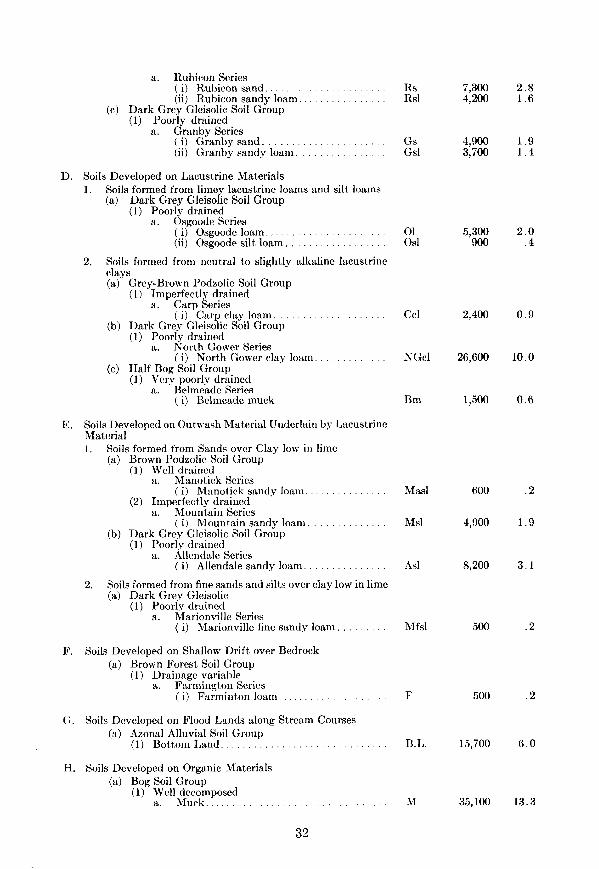
A summary key of soils of Stormont County is presented below along with the map symbol and total acreage of each soil type.
Summary of the Classification of the Soils of Stormont County
-4. Soils Developed on Till 1. Soils formed from loamy calcareous till
(a) Brown Forest Soil Group (I ) Well drained
Grenville Series ” (i) G renville loam. . . . . . Gl
(ii) Grenville loam-boulderv phase. . . Gl-b Y * b. Earner Series
( i) Earner loam. . . . El (2) Imperfectly drained
a. Matilda Series ( i) Matilda loam. . . . . . . . Ml
(b) Dark Grey Gleisolic Soil Group (1) Poorly drained
a. Lvons Series ( i) Lyons loam. . . . . . . . . . . . . IAl
2. Soils formed from fine textured calcareous till (a) Brown Forest Soil Group
(1) Well drained a. Wolford Series
( i) Wolford clay loam. . . . . . . . WC1 (2) Imperfectly drained
a. Morrisburp: Series ( i) Morriiburg clay loam. . . . . MC1
(b) Dark Grey Gleisolic Soil Group (I ) Poorly drained
a. Osnabruck Series ( i) Osnabruck clay loam. . . . . Obcl
MAP % SYMBOL ACREAGE TOTAL
47,700 18.1 1,800 .7
26,400 10.0
4,600 1.7
1,300 .5
13,000 5.0
20,500 7.7
3,400 1.3
B. Soils Developed on Roughly Stratified Sand and Gravel (a) Grey-Brown Podzolic Soil Group
(1) Well drained
‘* Kars Series ( i) liars gravelly sandy loam. . . . . . . . Kg 19,100 7.2
C. Soils Developed on Deltaic or Outwash Materials 1. Soils formed from deltaic sands
(a) Podzol Soil Group (1) Well drained
a. Uplands Series ( il Uplands sand. . (ii) Uplands sandy loam.
(b) Ground Water Podzol Soil Group (1) Imperfectly drained
. us 2,400 . . us1 1,200
31
a. Rubiron Series ( i) Rubicon sand. . (ii) Rubicon sandy loam.
(c) Dark Grey Gleisolic Soil Group (1) Poorly drained
a. Granby Series ( i) Granby sand. . . . (ii) Granby sandy loam.
El
Gs Gsl
7,300 2.8 4,200 1.6
4,900 3,700
1.9 1.4
D. Soils Developed on Lacustrine Materials 1. Soils formed from limev lacustrine loams and silt loams
(a) Dark Grey Gleisoiic Soil Group (1) Poorly drained
a. Osgoode Series ( i) Osgoode loam. . . . (ii) Osgoode silt loam. . . . . . . . .
5,300 900
2.0 .4
2. Soils formed from neutral to slightly alkaline lacustrine clays (a) Grev-Brown Podzolic Soil Groun \ I
(1) uImperfectly drained a a. Carp Series
( i) Carp clay loam. . . (b) Dark Grey Gleisolic Soil Group
(1) Poorly drained a. North Gower Series
( i) North Gower clay loam. (c) Half Bog Soil Group
(1) Very poorly drained Belmeade Series
a* ( i) Belmeade muck
Ccl 2,400 0.9
NGcl 26,600 10.0
Bm 1,500 0.6
E. Soils Developed on Outwash Material Underlain by Lacustrinc Material 1. Soils formed from Sands over Clay low in lime
(a) Brown Podzolic Soil Group (1) Well drained
Manotick Series a’ (i) M anotick sandy loam.
(2) Imperfectly drained Mountain Series
” ( i) M ountain sandy loam. . . (b) Dark Grey Gleisolic Soil Group
(1) Poorly drained a. Allendale Series
( i) Allendale sandy loam. . . I . .
2. Soils formed from fine sands and silts over clay low in lime (a) Dark Grey Gleisolic
(1) Poorly drained Marionville Series
” (i) M arionville fine sandy loam. . . .
Masl 600 .2
Ms1 4,900 1.9
As1 8,200 3.1
Mfsl 500 .2
F. Soils Developed on Shallow Drift over Bedrock (a) Brown Forest Soil Group
(I) Drainage variable Farmington Series
” (i) F arminton loam. . . F
B.L.
500
15,700
.2
6.0
c:. Soils Developed on Flood Lands along Stream Courses (a) Azonal Alluvial Soil Group
(1) Bottom Land. . . . .
H. Soils Developed on Organic Materials (a) Bog Soil Group
(1) Well decomposed a. Muck................................. M 35,100 13.3
32
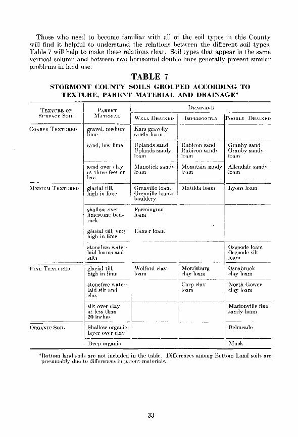
Those who need to become familiar with all of the soil types in this County will find it helpful to understand the relations between the different soil types. Table 7 will help to make these relations clear. Soil t,ypes that appear in the same vertical column and between two horizontal double lines generally present similar problems in land use.
TABLE 7 STORMONT COUNTY SOILS GROUPED ACCORDING TO
TEXTURE, PARENT MATERIAL AND DRAINAGE*
TEXTLRE OF SI-RFACE SO11 ,
- ('0.4~~ TEXTURED
FINE TEXTURFI) J
_____- ORGANIC Son
PARENT MATERIAL
gravel, medium lime
sand, low lime
__------ sand over clay at three feet 01 less
glacial till, high in lime
--~ shallow over limestone bed- rock
glacial till, very high in lime
----- stonefree water- laid loams and silts
glacial till, - high in lime
stonefree water- laid silt and clay
silt over clay at less than 20 inches
Shallow organic layer over clay
Deep organic
DRAINAGE
WELL DRAINEI)
Kars gravelly sandy loam
Uplands sand Uplands sandy loam
Manotick sandy Mountain sandy loam loam
Grenville loam Grenville loam- bouldery
Farmington loam
PIamer loam
Wolford clay loam
Rubicon sand Rubiron sandy loam
llntilda loam
JZorrisburg clay loam
Carp clay loam
POORLY DRAINED
Granby sand Granby sandy loam
Allendale sandy loam
Lyons loam
Osgoode loam Osgoode silt loam
Osnabruck clay loam
North Gower clay loam
Marionville fine sandy loam
Belmeade
Muck
*Bottom land soils are not included in t,he table. Differences among Bott,om Land soils are presumably due to differences in parc>nt materials.
33

DESCRIPTION OF STORMONT COUNTY SOILS A. SOILS DEVELOPED ON TILL
1. Soils formed from loamy calcareous till
The loam textured till materials found in Stormont County may be divided into two groups on the basis of the carbonate coment. The moderately calcareous till is derived from Black River limestone predominantly, while the highly calcareous till is underlain by Trenton limestone. An analysis of the Trenton limestone formation is presented in Table 3.
The Grenville catena includes the medium textured soils developed on those sections of the till plain underlain by Black River formation. The Grenville catena consists of the well drained Grenville series, the imperfectly drained Matilda series and the poorly drained Lyons series. The well drained soils developed on Trenton limestone materials are classified as the Earner series. The imperfectly and poorly drained associates of the Earner series have not been separated from the corresponding members of the Grenville catena.
Grenville Series (49,500 acres)
The Grenville series is developed from morainic material that, in Stormont County, is underlain predominantly by limestone of the Black River formation. The topography on which the series developed is undulating to slightly rolling. On the gentler slopes, areas of imperfect drainage having soil similar to Matilda loam may occur as a result of seepage from adjacent areas of higher elevat,ion. The Grenville series belongs to the Brown Forest Great Soil Group.
Grenville loam (47,700 acres) Grenville loam-bouldery phase (1,800 acres)
The following is a description of the Grenville loam as commonly found in uncultivated woodlots in Stormont County:
A, - s-0 inch of matted leaves and t#wigs. A1 - O-4 inches of very dark grey-brown (IOYR 3,/2) *
loam ; friable consistency; medium crumb structure; medium in organic matter; few stones; no free carbonates; pH-7.0.
B1 - 4-7 inches of light brown (1 OYR 6/3) loam; friable consistency; weak small nuciform structure ; very indistinct horizon ; pH-6.8.
Bz - 7-16 inches of dark grey-brown (10YR 4/2) loam; friable consistency; medium nuciform structure; few stones; no free carbonates; pH-7.0.
C1 - 16-26 inches of dark grey-brown (10YR 4/2) loam; stony; free carbonates; not compacted; pH-7.6.
C2 - Grey (1OYR 5/l) or grey-brown (10YR 5/2) loamy till; stony; slightly compacted; calcareous; pH-7.8.
The parent material consists of unsorted till dominated by limestone with some sandstone fragments.
Stones occur throughout the profile and, in some areas, boulders occur on the surface in sufficient numbers to interfere with cultivation. Such areas are mapped as the bouldery phase of the Grenville loam.
When cultivated, the surface soil becomes a grey-brown loam of medium organic
*Colour code numbers as taken from Munsell Colour Chart.
34

matter content. some elm.
The natural vegetation includes sugar maple, beech, ash, and
Agriculture Most of the Grenville loam is now cleared and used for agricultural purposes.
General farming and dairying are carried on to advantage as, corn, alfalfa, clover, and small grains thrive on this soil type.
The supply of plant nutrients and lime is medium. The type of agriculture that stresses dairying provides a good supply of barnyard manure for return to the soil. For the production of clovers and alfalfa, applications of potash and phosphorous prove profit,able; nitrogen should also be added for cereals and corn.
The fert,ility of the Grenville loam-bouldery phase is similar to the normal type but the stoniness hinders cult’ivation. If the boulders are not too numerous, it may be economical to remove them but, in most instances, the bouldery phase is used for pasture production.
In a few areas where drumlins are common, erosion may be a problem especially if row crops are grown. Xormal good management practices, however, usually suffice to control erosion on the Grenville soil type.
Earner Series (26,400 acres) Another group of soils developed on loamy till in Stormont County is the Earner
series. The soils of this series are well drained and are developed on till that, being derived from Trenton limestone, is higher in lime than the till of the Grenville series. The topography is strongly undulating to rolling resulting in greater sus- ceptibility to erosion than on the latter series.
The series includes only one type, Earner loam (26,400 acres). The profile characteristics exhibited are those of the Brown Forest Great Soil Group. A description of a virgin profile of Earner loam is presented below:
A,, - >&O inch of matted leaf litter. A1 - O-5 inches of very dark grey (IOYR 3/l) loam;
friable consistency; medium crumb structure; me- dium to high in organic matter; few stones; free carbonates may be present; pH-7.0.
RI - 5-10 inches of dark grey-brown (1OYR 4/2) loam; friable consistency; fine nuciform structure; few stones; free carbonates; pH-7.0.
Bz - lo-18 inches of very dark grey-brown (IOYR 3/2) loam ; friable consistency; medium nuciform struc- ture; stones and boulders; free carbonates; pH-7.2.
CI - 18-23 inches of grey-brown (1OYR 5/2) loam; slightly compacted ; very weak fine nuciform structure; stony ; calcareous ; pH-7.6.
C2 - Grey (1OYR 5/ 1) loamy calcareous till; stony; somewhat compacted; pH-8.0.
The parent material is characteristically stony but in some areas where eskeroid deposits are present it becomes excessively stony. The parent material has some tendency to be compacted but no hardpan layer is developed in this soil.
A number of boulders chiefly limestone with some granite erratics are scattered about the surface often in sufficient numbers to hinder normal cultivation.
The natural vegetation includes sugar maple, elm, and basswood. The internal and external drainage is good. When cultivated, the surface soil consists of a dark grey-brown loam of medium organic matter content.

N a t u r a l v e g e t a t i o n o n w e l l d r a i n e d s o i l s c o n s i s t e d o f m a p l e , b e e c h ,a sh , a s soc ia t i on .
A g r i c u l t u r e
The Earner loam is well adapted to general farm crops provided that the bouldersare not too numerous. It is well supplied with lime and is fairly well supplied withother available plant nutrients. Cereals, hay, especially alfalfa and clovers, andpasture thrive on this soil. Addition of phosphatic fertilizers may give profitableincreases in yields.
Because the topography is strongly undulating to rolling, there are many slopeson which erosion is a problem. On certain slopes, it may be advisable to break upthe sod only about once in five years to renew the hay and pasture.
M a t i l d a S e r i e s ( 4 , 6 0 0 a c r e s )
The Matilda series represents the imperfectly drained member of both theGrenville and the Earner catenas. It was not possible to differentiate between theinadequately drained members of the two catenas. Matilda loam, the only typein the series, is an imperfectly drained Brown Forest Soil. The profile horizonsare less distinct than in the well drained soils due chiefly to the imperfect drainage.The type occurs on undulating topography and on the lower slopes of drumlins.
The following is a description of a Matilda loam profile under cultivation:Ac—0-8 inches of greyish brown (10YR 5/2) loam; friable
consistency; medium crumb structure; few stones;medium organic matter content; no free carbonates;pH—7.0.
B1—8-15 inches of brown (10YR 5/3) loam; slightlymottled; friable consistency; fine crumb structure;pH—6.8.
B2—15-22 inches of brown (10YR 5/3) loam; mottled;friable consistency; weak nuciform structure; horizon
36

is relatively indistinct and not always present; pH-7.0.
C - Grey (IOYR 6/‘1) 1 oamy calcareous till; stony; free carbonates; pH-7.4.
The parent material varies in pH from 7.2 to 8.0. It tends to become compacted and to hinder the natural internal drainage. The relatively smooth relief contri- butes to inadequate external drainage.
In some areas, considerable water washing has mixed some lacustrine material \vith the till materials. Such profiles are irregular in occurrence in areas that are too small to delineate.
The natural vegetation consists of elm with some maple on the better drained sites.
When cultivated, the surface soil is a grey-brown loam of medium organic matter content.
Agriculture
In general, the Matilda loam is used for semi-permanent pasture and hay production. It is fairly well supplied with nutrients and lime. Where local drainage conditions are improved, it compares favourably with the Grenville loam as an agricultural soil.
Artificial drainage is of value in this soil provided that the number of stones does not make tile drainage impractical. Buckwheat is well adapted to this type and, with favourable weather at seeding time, some spring grains can be grown even without improved drainage.
Lyons Series (1,300 acres)
The Lyons series, which is the poorly drained member of the Grenville and Earner catenas, is represented in Stormont County by the Lyons loam. It belongs to the Dark Grey Gleisolic Group of soils. It exhibits the characteristics of that Great Group as evidenced by the profile description below:
With the exception of the AC, the profile horizons are poorly defined.
A, - O-10 inches of very dark brown (IOYR 2,/a) stony loam; high in organic matter; sometimes free car- bonates are present; pH-7.2.
G - lo-24 inches of mottled grey (IOYR 5/l) stony loam that grades into the parent material; pH-7.5.
C - Grey calcareous stony till; pH-7.8.
The entire profile is usually stony and makes artificial drainage impractical. The topography is depressional; hence there is often considerable seepage from adjoining uplands. A4s the amount of organic matter in the surface layer increases, the type grades into areas of muck.
Most of the soil of this t!ype is support,ing its natural vegetation of cedar, poplar, and elm.
Agriculture The surface soil is fairly well supplied with plant nutrients but the poor drainage
limits the type chiefly to the production of permanent pasture.
2. Soils formed f rom jine textured calcareous till
The bedrock formations of the southwestern portion of Stormont County are Chazy shale and Black River limestone. The morainic material developed on these formations is high in lime and has a clay loam texture. Hence, the soils developed
37

are highly calcareous and the parent materials tend to be compacted producing a hardpan layer at depths varying from 18 to 36 inches below the surface.
Only one catena, the Wolford cantena, has been recognized on these materials in Stormont County. All three members of the catena occur in the southwestern part adjoining Dundas County. The catenary members are the well drained Wolford series, the imperfectly drained Morrisburg series and the poorly drained Osnabruck series.
Wolford Series (13,000 acres) The Wolford series is developed from fine textured high lime till on undulating
to very gently rolling topography. The Wolford clay loam is the only type mapped in Stormont County and it represents the well drained member of the Wolford catena. The profile is typical of t,he Brown Forest soils. Brown is the dominant colour throughout the profile as evidenced by the description below:
A, - s-0 inch of matted leaf litter and dead grass. A1 - O-5 inches of very dark brown (1OYIt 2/2) clay loam;
friable consistency ; medium crumb structure ; numer- ous fibrous roots; medium in organic matter; occa- sional stones; free carbonates present; pH-7.2.
B1 - 5-8 inches of dark brown (10YR 4/3) clay loam; friable consistency; medium nuciform structure; few stones; free carbonates; pH-7.3.
BZ - 8-11 inches of very dark greyish brown (1OYR 3/2) clay loam; friable consistency; fine blocky structure; several stones; free carbonates; pH-7.3.
Bs - 11-15 inches of dark brown (10YR 4/3) clay loam; friable consistency ; coarse blocky structure ; several stones; free carbonates; pH-7.4.
C1 - 15-20 inches of light brownish grey (1OYR 6/2) clay loam till; stony; somewhat compacted; free car- bonates; pH-7.8.
Cz - Grey (1OYR 6/l) clay loam till; calcareous; quite compacted ; &ony ; pH-8.0.
The parent, material is usually more or less compacted. The weathered profile varies between 20 and 30 inches in depth. In some places, the type is found in close association with in the profile.
eskeroid material and the presence of some gravel is evident
The-Wolford clay loam usually occurs in sma inadequately drained members of the catena. maple and basswood.
11 areas within large areas of the The natural vegetation is elm,
The cultivated surface soil is a dark brown clay loam with a medium supply of orgariic matter and plant nutrients. Lime is present throughout the profile.
Agriculture When cleared, the Wolford clay loam is used to produce hay, corn, and small
grains. It is especially well suited to alfalfa growing. The soil is of medium fertility well supplied with lime. Because of the high
lime content, crops probably will respond well to applications of phosphorus as commercial fertilizer to this soil. The greatest hindrance to crop production, however, is the presence of the compacted subsoil. The undulating to gently rolling topography results in some erosion on the steeper slopes. Ordinary good farm practices will keep erosion in check in most instances.
38

Morrisburg Series (20,500 acres)The most extensive series found on the fine textured morainic till deposits is the
Morrisburg series. It is the imperfectly drained member of the Wolford catena.Morrisburg clay loam developed on undulating topography is the only type inthe series to be recognized in Stormont County. The imperfectly drained BrownForest Group profile of the Morrisburg soil is described as follows:
A0—½-0 inch of dark matted leaf litter.A1—0-6 inches of dark brown (10YR 4/3) clay loam;
friable consistency; medium crumb structure; fewstones; free carbonates; pH—7.2.
B1—6-10 inches of dark yellowish brown (10YR 4/4)clay loam; friable consistency; small nuciformstructure; slightly mottled; free carbonates; (horizonmay be mistaken for an indistinct A2); pH—7.3.
B2—10-15 inches of brown (10YR 4/3) clay loam;friable consistency; small nuciform structure; mot-tled; free carbonates; few stones; pH—7.4.
C—Grey (10YR 6/l) clay loam; compacted; stony;free carbonates; pH—8.0.
The profile may vary somewhat in depth but the average is about eighteeninches to the parent material where the compacted subsoil occurs. The stoninessof the profile increases in areas adjacent to eskeroid material. Appreciable amountsof sandstone, presumably originating from the Potsdam formation, are presentwithin the profile while granite erratics may be scattered about the surface. Thesoil appears to be shallow; the shallowness, however, is not due to the proximityof the bedrock but rather to the compacted layer. This condition is reflected inthe natural vegetation that consists of elm, soft maple and numerous cedars.
L e g u m e s a r e e f f i c i e n t s u b s o i l i m p r o v e r s a n dproduce good forage as wel l .
39

Under cultivation, the surface soil becomes a grey-brown clay loam organic matter content and is fairly well supplied with plant nutrients.
Agriculture
of medium
When cleared, the soil type is used for the production of cereal grains, and, even in wet seasons, it produces commendable crops of buckwheat. It is a fairly good soil for the production of alfalfa and clover which, in turn, tend to break up the compacted subsoil for improved drainage.
Art,ificial drainage would be of value but the cost of ilistallation is probably prohibitive in many instances.
Osnabruck Series (3,400 acres) Osnabruck clay loam, the only member of t,he Osnabruck series, is the poorly
drained member of the Wolford catena. It is developed in fine textured calcareous till on level to depressional topography. It belongs to the Dark Grey Gleisolic Great Soil Group. The general description of the profile is as follows:
A(, - thin layer of black leaf litter. -A1 - O-10 inches very dark brown (1OYR Z/2) clay loam ;
friable consistency; coarse crumb structure; high organic matter cont)ent ; few stones; free carbonates present; pH-7.4.
G - IO-16 inches light brownish grey (IOYR 6/2) clay loam ; plastic consistency ; massive structure ; heavily mottled ; free carbonates present; pH-7.6.
C - Grey (IOYR S/l) clay loam till; very stony; cal- careous; PI-I---8.0.
As a result of its topographic position, the profile often includes varying amounts of water-washed fine textured material deposited over the till.
Boulders often occur in considerable numbers on the surface. The organic matter content of the surface soil varies considerably and becomes greater nearer muck areas.
Agriculture The lack of drainage, both internal and external, seriously limits the usefuhiess of
the Osnabruck clay loam for production of general farm crops. The relatively large number of stones within the profile makes drainage improvement of doubtful economic value. Some areas have been cleared and are used for permanent pasture. One of the best uses for the type, however, is the production of its natural vegeta- tion of elm, cedar and willow.
B. SOILS DEVELOPED ON ROUGHLY STRATIFIED SAND AND GRAVEL (GLACIO-FLUVIAL MATERIAL)
As the last great ice sheet melted, streams of meltwater made their way through great crevasses in the ice and finally flowed out in front of the glacier. Rock debris which was originally held by t)he ice was carried by the streams, and was deposited in their beds. When the ice finally melted from the area, the beds of the glacial streams remained as long narrow ridges of coarse sand and gravelly material. As a result of t8he above mode of deposition the relief is hilly, a condition that, does not readily lend itself to general farming practices.
Kars Series (19,100 acres) All of the glacio-flu\4al material in Stormont County is classified in the Kars
series. This series is well drained. The remaining catenary members were not recognized in areas large enough to delineate in Stormont County.
40

The Kars series is represented by one soil type, the Kars gravelly sandy loam.The usual topographic form is one of long narrow ridges whose long axes areroughly parallel to the direction of ice movement. The profile is well drained and,in some instances, excessively drained. The profile characteristics identify theKars with the Grey-Brown Podzolic Group of soils.
A0—½-0 inch layer of leaf litter.A1—0-4 inches of dark grey-brown (10YR 4/2) sandy
loam; very friable consistency; very fine crumb tosingle grain structure; few stones; pH—6.8.
A2—4-12 inches of yellow-brown (10YR 5/6) sandy loam;very friable consistency; single grain structure; fewstones; pH—6.6.
B—12-17 inches of dark brown (10YR 4/3) loam orsandy loam ; friable consistency; small nuciformstructure; few stones; pH—7.0.
C—Roughly sorted gravel and sand; some free car-bonates; some boulders; pH—7.0, contains someshale fragments.
The above profile developed under well drained conditions. Wherever thedrainage is excessive, the horizon development is less distinct.
The natural vegetation is maple with some beech and pine. Elm may occur inslight depressions.
There were many small cobble stones scattered about the surface, under naturalconditions, but most of these have been removed from cultivated land and placedin stone piles. The cultivated surface soil is a light grey-brown sandy loam, lowin organic matter. It is also low in essential plant nutrients: hence fertilization isnecessary if the soil is used for general farm crops.
AgricultureThe suitability of the Kars series for general farming is limited by several factors.The stones that occur in the upper horizons may hinder the use of farm machinery.
The removal of the boulders from the surface increases the cost of bringing the
The parent materials of the Kars series are often used for roadb u i l d i n g . T h e c o a r s e t e x t u r e d m a t e r i a l s p r o m o t e r a p i d d r a i n a g e .
41

soil into production and as the inherent productivity of the soil is low, stone removal may not be economical.
For specialized early crops such as pot,atoes and small fruits, the type is well suited provided that commercial fertilizer is used.
The rolling topography is conducive to erosion. Hence, during cultivation, the control of erosion is a problem. In addition, the coarse open subsoil tends to cause the soil to be droughty although the B horizon, which is relatively heavy in texture, aids in retaining a favourable moisture relationship.
During wet seasons, the Kars gravelly sandy loam becomes one of the better soils in the County for general farm crops because of its good drainage.
C. SOILS DEVELOPED ON DELTAIC OR OUTWASH MATERIALS The parent materials of this group of soils were deposited by water as it flowed
out over the area in front of the glacier. As t,he rate of flow of the water decreased particles of sand and fine gravel settled out to form the outwash plains of to-day. The topography is undulating with some gullying along st,ream courses. The largest acreage of out,wash material occurs in Roxborough Township.
All outwash material that is three feet or more in depth is classified in the T_Jplands catena which includes the well drained Uplands series, the imperfectly drained Rubicon series and the poorly drained Granby series.
Uplands Series (3,600 acres) The Uplands series has developed on strongly undulating to rolling outwash
materials of sand or sandy loam texture. The Uplands sand and Uplands sandy loam are members of the series developed under good to excessive drainage condi- tions. The open nature of the subsoil and the low lime content of the parent material favours the development of a Podzol type of profile. The Uplands sand profile described below belongs to the Podzol Great’ Soil Group:
Uplands sand (2,400 acres) Uplands sandy loam (1,200 acres)
A, - O-3 inches of very dark grey (10YR 3/l) sand; extremely friable consistency; single grain structure; medium to low in organic matter; pH-6.0.
A2 - 3-5 inches of grey (IOYR 5/l) sand; very friable consistency; single grain structure; pH--5.8.
B - 5-17 inches of brown (IOYR 5/3) sand; friable con- sistency; single grain to weak nuciform structure; pH-6.4.
C1 - 17-24 inches of yellow-brown (1OYR 5/6) sand; friable consistency; single grain structure; pH-6.4.
C:! - Grey (1OYR 5/l) sand and gravel ; non-calcareous ; pH-6.6.
There are no boulders within the profile, although a very occasional one may be found on t,he surface. If the soil is unprotected, “blow out” spots t,end to develop. Coniferous forest is the common natural vegetation. The cultivated surface soil is very low in organic matter. Chemical tests indicate that the available plant nutrients also are in short supply.
Agriculture
A large proportion of the Uplands soil has been cleared and cultivated but has ilO\V been returned to pasture. The soil is not well suited to general farming because
42

of low fertility and a tendency to be droughty. With adequate fertilization,and potatoes can be grown during seasons of favourable moisture supply.
grain
The Uplands sandy loam is more useful than the Uplands sand because of itshigher fertility level. Also during wet seasons, the sandy loam is very usefulbecause the fine textured soils are hindered by excess moisture. Uplands sandyloam is well suited for specialized crops such as potatoes.
Rubicon Series (11,500 acres)The imperfectly drained member of the Uplands catena is the Rubicon series.
The two types, Rubicon sand and Rubicon sandy loam, are developed on undulatingtopography with numerous small knolls and depressions. The drainage conditionsvary within very short distances ranging from good drainage on the knolls topoor drainage in the depressions. The Rubicon series is classified as a GroundWater Podzol although on the better drained knolls an Uplands podzol maydevelop and in the poorly drained depressions the Granby series may occur.
The Up lands sand pro f i l e has ind i s t inc t hor i zons . Low f e r t i l i t y andsuscep t ib i l i t y t o w ind e ros ion l im i t the p roduc t i v i t y o f the so i l .
Rubicon sand (7,300 acres)Rubicon sandy loam (4,200 acres)
A description of an average profile under cultivation appears below:Ac—0-5 inches of dark grey (10YR 4/l) sand or sandy
loam; very friable consistency; single grain structure;pH—6.5.
A2—5-10 inches of ashy grey (10YR 7/l) sand; veryfriable consistency; single grain structure; pH—6.0.
B—10-20 inches of dark brown (10YR 4/3) sand or
43

sandy loam ; somewhat cemented ; compact ; pH-6.2 ; grades into mottled brown sand.
C - Grey (IOYR 5/l) sand sometimes stratified with silt or gravel; pH-6.8.
There are practically no stones throughout the profile nor on the surface. Under cultivat8ion the surface soil is a yellow-brown on the knolls and dark grey
in the depressions with streaks of ashy grey scattered throughout wherever the plow reaches the A:! horizon. The soil in the depressions is often closely similar to the Granby as described later. The soil is moderately acid and low in plant nutrients.
Agriculture The utility of this soil type is quite variable depending on the area of well drained
knolls in proportion to the area of inadequately drained depressions. The open nature of the soil materials renders the retention of moisture poor where the water table is low. The depressions usually require drainage but this draining only accentuates the problem of moisture control on the knolls. In areas where clay occurs relatively close to the surfaye (3-6 feet) drainage is frequently difficult to improve.
Some farmers carry on a general type of farming on the Rubicon sandy loam where the topography is relatively level and where the subsoil is eit’her calcareous gravel or clay. The sandy loam type is the more useful of the series and is valuable during wet seasons when finer textured soils fail to produce.
Granby Series (8,600 acres)
Depressional t)opography on sandy outwash material leads to the development of the poorly drained profile of the Granby series. The series includes the Granby sand and the Granby sandy loam.
Granby sand (4,900 acres) Granby sandy loam (3,700 acres)
Both types belong to the Dark Grey Gleisolic Soil Group and have profile characteristics as described below :
A, - 1-O inch of matted leaf litter. A1 - O-5 inches of very dark brown (IOYR 2/2) sand or
sandy loam; very friable consistency; single grain structure; pH-6.8.
G1 - 5-11 inches of grey (1OYR 5/l) sand; very friable consistency; single grain structure; pH-6.8.
Gz - 11-33 inches of grey (1OYR 5/l) sand mottled with rusty brown; friable consistency; single grain struc- ture; pH-6.9.
C - Grey (1OYR G/l) sand stratified with some clay and silt; no free carbonates; pH-7.0.
At a depth of three feet or more, clay may be present but it has no obvious effect on the profile developed nor on the productivity of the soil. The native vegetation is elm, soft maple, cedar, and spruce.
The natural surface soil is well supplied with organic matter that may be lost rapidly when the soil is drained and cultivated. The content of available plant nutrients is also low.
Agriculture The native vegetation has been removed from much of the area but when the
uselessness of the soil for farming was realized, the area was allowed to revert to
44

the production of scrub willow. The soil is one of the poorest types in the County and is probably serving its best purpose in producing trees. Fortunately there is only a small acreage of Granby in Stormont County.
If drainage and fertility are improved, good crops of hay and pasture can be produced. When drainage is improved, however, the soil tends to be droughty as a result of its coarse texture. The Granby sandy loam is somewhat better for agricultural purposes than the sand type although it possesses the same limitations to some degree.
D. SOILS DEVELOPED ON LACUSTRINE MATERIALS Lacustrine materials are of medium to fine texture having been deposited by
still or very slowly moving water. As the glacier receded, much of this eastern portion of Ontario was inundated by glacial Lake Champlain and Gilbert Gulf. The particles carried by the water flowing into the lake gradually settled t,o the lake bed. The farther retreat of the ice allowed the lakes to drain and so today only the beds of the lakes remain. The fine textured lacustrine plains represent the lake beds of late glacial times.
In general, lacustrine deposits are of fine texture ranging from a loam to clay, are stonefree, and usually are inadequately drained as a result of their level topography.
1. Soils formed from limy lacustrine loams and silt loams
The materials classified in this group are a mixture of clay sediments and coarser materials washed in from adjoining till and gravelly ridges. Great irregularity of layering of coarse and fine materials is found throughout the profile. This supports t,he belief that the mode of deposition had the dominating effect) on t’he texture of the materials. Only one catena has been mapped on these materials and the Osgoode series is the only member of the cat)ena to be recognized.
Osgoode Series (6,200 acres) The Osgoode series commonly occurs as a transition between areas of lacustrine
clay and areas of coarser materials (e.g. till and outwash). It appears to be a random mechanical mixture of sand and clay. The t)opography is level to depres- sional. Two types are included in the series that exhibits Dark Grey Gleisolic profile characteristics.
Osgoode loam (5,300 acres) Osgoode silt, loam (900 acres)
The following is a description of the loam profile under t’he original forest cover: A,, -- s-0 inch of matted leaf litter. A1 - O-6 inches of dark grey (IOYR 4/l) loam; friable
G *
GZ
Cl
-
-
consistency ; fiiie granular structure; stonefree; no free carbonates; medium to high in organic matter; pH-7.0. 6-9 inches of light brownish grey (1OYR C,/2) loam; friable consistency; weak medium nuciform struc- ture; some weak mottling; no free carbonates; stone- free; pH-6.8. 9-21 inches of grey-brown (1OYR 5,/2) loam ; weakly plastic consistency; massive structure; mottled; stonefree; no free carbonates; pH-7.0. Grey (1OYR 5/l) loam; plastic consistency; massive structure; mottled; free carbonates may be present; pH-7.4.
45

The parent material may have lenses or layers of sandy material intermixed with layers of clay but no stones are present.
The natural vegetation consisted of soft, maple, elm, and ash. Under natural conditions, the surface soil is fairly high in organic matter which it retains under cultivation if reasonably well managed.
Agriculture For the most part the Osgoode loam is farmed intensively. The fertility level is
medium but the restricted drainage is a limit,ing fact,or. The drainage problem can usually be overcome by installation of open ditches and tile drains. The t,ype does not occur in large areas; hence any one farm is not likely to be all Osgoode loam. Hay (red clover and alsike), pasture, and cereal grains are crops commonly grown on this soil. Osgoode loam in association with a well drained soil type is an ideal combination for dairy farming.
Osgoode silt loam This type has profile characteristics similar to those of the Osgoode loam except
that the surface soil is a silt loam. The finer texture provides slightly high fertility but the same use is made of the two types. The fine texture may increase the problem of drainage but this can be overcome fairly economically.
2. Soils.formed from neutral to slightly alkaline lacustrine clays
The Carp, North Gower, and Belmeade series have developed on grey clays and silts moderately high in lime. The largest area of such materials is found in Finch Township in the northwest part of the County along the South Nation River. In the remainder of the County, the poorly drained series occur in depressions between ridges of till or gravel.
The Carp catena includes all of the lacustrine clays in Stormont County. The Carp series is the imperfectly drained catenary member, the North Gower series the poorly drained, and the Belmeade series is the very poorly drained member.
Carp Series (2,400 acres) The Carp series includes those soils that are developed on neutral to slightly
alkaline, stonefree, lacustrine material under conditions of imperfect drainage. The areas of the Carp series are very limited and occurs close to stream courses. Some small areas of moderately well drained soils are included because such areas are too small to delineate. The Carp clay loam which is the only member of the series recognized is developed on gently undulating topography. It shows the profile characterist,ics of an imperfectly draiiied Grey-Brown Podzolic soil. The following is a description of the virgin profile of the Carp clay loam :
A, - ?$-0 inch of matted leaf litter. A1 - O-5 inches of dark grey-brown (IOYR 412) clay loam;
friable consistency; medium crumb structure; med- ium iii orgaiiic matter; stonefree; no free carbonates; pH-7.2.
AZ - 5-10 inches of light brownish grey (1OYR 6/2) loam or clay loam; friable consistency ; weak nuciform structure; stonefree; pH-7.0.
B1 - lo-17 inches of brown (1OYR 5/3) clay loam; very slightly mottled; hard consistency when dry; weak small blocky structure ; stonefree; pH-7.0.
Bo - 17-29 inches of grey (1OYR 5/l) clay loam; plastic
46

consistency; massive structure; mottled; stonefree:free carbonates sometimes present; pH—7.2.
C—Grey (10YR 6/l) silty clay loam; plastic consistency;massive structure; calcareous; pH—7.2.
The parent material is stonefree and fine in texture. The profile horizons arenot well defined but as drainage improves the horizon definition improves.
The topography is undulating and may become rolling as a result of erosion bysmall streams that have developed gullies. The gullies facilitate external drainagealthough the internal drainage is imperfect. Although the Carp clay loam is afine textured soil, its favourable structure greatly improves the internal drainageand the general productivity.
The natural vegetation was maple, elm and ash. The natural surface soil isfairly well supplied with organic matter which it retains under cultivation if thesoil is reasonably well managed. The supply of most plant nutrients is mediumto high.
AgricultureMost of the small acreage of Carp clay loam which occurs in Stormont County
has been cleared. It is a good agricultural soil being well adapted to the growingof small grains, corn, alfalfa, hay and pasture. Artificial drainage is usually requiredfor maximum production. The natural fertility is medium to high and may bemaintained by ordinary good farm practices. The management problems are lessserious on the Carp clay loam than on the poorly drained members of the catena.
North Gower Series (26,600 acres)The North Gower series occurs on materials similar to those of the Carp series
but is differentiated on the basis of drainage. The North Gower series includes finetextured soils of neutral to slightly alkaline reaction that are poorly drained.
Along the banks of the South Nation River in Finch Township, there are largeareas of the North Crower series and smaller areas occur in other parts of the County.The level to depressional topography promotes poor drainage. The North Gowerclay loam is the only member of the series mapped in the County. It belongs to
I n s t a l l a t i o n o f d e e p o p e n d i t c h e s a n d t i l e d r a i n s i s r e q u i r e don North Gower soils .
47

the Dark Grey Gleisolic Soil Group. A description of a virgin profile is presentedbelow :
A0—½-0 inch of matted leaf litter.A1—0-8 inches of very dark grey (10YR 3/l) clay loam ;
friable consistency; medium crumb structure; stone-free; medium to high in organic matter; pH—7.0.
Gl—8-12 inches of grey (10YR 5/l) clay loam; plasticconsistency; massive structure; mottled; stonefree;pH—7.0.
G2—12-26 inches of grey (10YR 5/l) clay loam; plasticconsistency ; massive structure ; intensely mottled ;stonefree; pH—7.2.
C—Grey (10YR 6/l) silty clay loam; plastic consistency;massive structure ; stonefree ; free carbonates present ;pH—7.4.
The parent material is usually stonefree although some grit may be present.The poor drainage results in horizons that are very indistinct and mottling oftenoccurs immediately below the dark coloured A1 horizon.
The natural vegetation consisted of elm, ash and soft maple. The organicmatter content of the surface soil is medium to high and it is well incorporatedwith the mineral matter. The cultivated soil is very dark brown in colour with amedium to high fertility. The phosphorus and potash contents of the NorthGower series are appreciably higher than those of comparable lacustrine depositsin Western Ontario.
AgricultureA large percentage of this type in Stormont County has been cleared and is
being used for permanent pasture prodution with no improvement in drainage.Cereal grains and some corn are grown, however, where ditches and tile drainshave been installed.
C e r e a l g r a i n s g r o w w e l l o n p o o r l y d r a i n e d c l a y s o i l s w h e n d r a i n a g ehas been improved art i f ic ial ly .

General farming and dairying are common especial ly where well drained t i l lareas occur in association with the lacustrine material. Cereal grains and alfalfamay be grown on the t i l l soi l while the poorly drained areas may be used forpasture and hay. The ut i l izat ion of the North Gower clay loam varies great lywith the season. The soil is naturally poorly drained and, therefore, during a wetseason i ts agricultural value is great ly decreased. Conversely, i f the season isdry, the fine textured soil holds moisture better than the coarser soils and bettercrops result.
Belmeade Series (1,500 acres)
Soils developed on materials of the Carp catena under conditions of very poor
Belmeade muck is a very poorly drained soi l . Note depth of muck overthe grey clay.

drainage are included in the Belmeade series. The topography is depressional. The Belmeade muck is the only member of the series and it exhibits the profile
characteristics of a Half Bog Soil. The profile that obtains under virgin conditions is described below :
A0 - O-15 inches of black (1OYR 2/l) layer of organic matter in varying stages of decomposition; pH-6.8.
G1 - 15-20 inches of grey (IOYR 5/l) clay; plastic con- sistency; massive structure; stonefree; pH-6.8.
GS - 20-36 inches of grey (10YR 6/l) clay; plastic con- sistency ; massive structure; mottled with rusty brown; stonefree; pH-6.8.
C - Grey (1OYR 6/l) clay or silty clay; plastic con- sistency ; massive structure ; stonefree ; occasionally free carbonates are present; pH-7.0.
The surface horizon under cultivation is quite variable. In some areas, the native forest has been removed and the organic surface layer partially burned in an effort to reclaim the soil for general agriculture. The effort has been successful in some areas and the organic matter remaining has been incorporated with the mineral soil. The surface layer then becomes a very dark grey clay or clay loam about G-8 inches deep very closely ressembling that of the North Gower series.
In many areas, however, the burning has been unsuccessful because the organic matter was completely burned and the grey subsoil low in organic matter has become the surface soil. This layer is difficult to handle because of poor aeration and low supply of available nutrients.
Agriculture Fortunately, the acreage of Belmeade muck in Stormont County is very small.
IMuch of the type is still in forest and natural pasture and probably is serving its best use in that state. Areas which have been cleared and prepared successfully for farming are used in the same manner as the areas of North Gower clay loam. ,4rtificially improved drainage allows the production of hay, pasture, buckwheat, and cereals in relatively dry seasons.
E. SOILS DEVELOPED ON OUTWASH MATERIALS UNDERLAIN BY LACUSTRINE MATERIAL
1. Soils *formed from sands and loams over clay
In some areas the lacustrine materials of the Carp catena are covered by a thin veneer of coarse textured material. The depth of the sandy overburden varies from six inches to three feet and in some places, the clay appears at the surface. In general, the profile is developed in the coarser materials although clay may occur in the B horizons and lower.
The Maliotick catena includes all areas of this sand-over-clay complex. The Manotick series is found on undulating topography where the drainage is good. The Mountain series is imperfectly drained and the Allendale series and IMarion- ville series are the poorly drained members of the catena.
Manotick Series (600 acres) The soil developed on an undulating well drained plain of sand underlain by
clay at three feet or less is called the Manotick series. The Manotick sandy loam is the only member of the series to be recognized.
The topography is moderately to strongly midulatiiig. External drainage is
50

good. The internal drainage through the sandy materials is good but when the water reaches the clay layer it is impeded. Provided that other factors are constant, the deeper the sandy overburden the better the internal drainage. The soil type belongs to the Brown Podzolic Great Soil Group. The following is a description of a cultivated profile:
A, - O-4 inches of grey-brown (1OYR 512) sandy loam; extremely friable consistency; tine crumb structure; stonefree; pH-6.6.
B1 - 4-15 inches of yellowish brown (IOYR 5/4) sandy loam; very friable consistency; single grain struc- ture; pH-6.4.
B2 - 15-27 inches of light yellowish brown (1OYR 6/4) sandy loam or loam: friable consistency; granular structure; occasionally somewhat cemented; pH-6.7.
C - 27-32 inches of grey (1OYR 6/l) sandy loam ; friable consistency; single grain structure; pH-6.8.
D - Grey clay layer occurs at 20” to 36” below the sur- face; plastic consistency; massive structure; stone- free; pH-6.8.
The underlying clay is not the parent material of the profile. The profile is developed within the coarse textured materials.
The natural vegetation consisted of pine and maple forest. The cultivated surface soil is a grey-brown sandy loam or loam with a medium to low organic matter content. The supply of available plant nutrients in the sandy materials is medium. As the clay approaches the surface, however, more of the plant roots can obtain nutrients from the clay and better growth results.
Agriculture There is only a small acreage of Manotick sandy loam in Stormont County.
Most of it has been cleared and is used for general farming. The sand-over-clay type has an advantage in that the sandy surface allows early spring cultivation while the fine textured subsoil has larger reserves of plant food and aids in moisture retention during dry periods. The nat,ural fertility is medium, but profitable crop response to applications of balanced fertilizer may be expected.
Mountain Series (4,900 acres) About! 2 per cent of the area of Stormont County consists of an imperfectly
drained sand-over-clay complex mapped as the Mountain series. It is the imper- fectly drained member of the Manotick catena developed on undulating t)opography similar to that of the Rubicon series. Hence, there are small areas of three to four feet, of moderately well drained sand-over-clay as well as small areas of one to two feet of moderately poorly drained sand-over-clay included in the areas mapped as the Mountain series. The only member of the series recognized is Mountain sandy loam which is an imperfectly drained Brown Podzolic soil. The description of the cultivated profile is presented below:
A, - O-4 inches of dark brown (IOYR 4/3) sandy loam; very friable consistency: fine crumb structure; medium organic matter content; pH-6.5.
AZ - 4-6 inches of grey (IOYR G/l) sand or sandy loam; very friable consistency; single grain structure; pH-6.0. (This horizon is often indistinct).

B, - 6-9 inches of pale brown (1OYR 6/3) sandy loam; sometimes weakly cemented; pH-6.2.
B, - 9-24 inches of pale yellow-brown (IOYR 6/4) sand or sandy loam; slightly mottled; friable consistency; single grain structure ; pH-6.G.
C - 24-32 inches of grey (1OYR 6/l) sandy loam; friable consistency; mot!tled; single grain structure; pH-6.8.
D -Grey (10 YR G/l) al c ag : plastic consistency; massive structure; stonefree; non-calcareous; pH-7.0.
The underlying clay is not the parent material of the profile although it has considerable influence on the moisture and fertility relationships of the soil.
The natural vegetation consisted of elm, pine and some poplar trees. The variability in the depth of the sandy overburden results in considerable variation in the fertility of the surface soil. In general, however, the surface soil is grey- bro\vIl in colour with a fair supply of organic matter.
Agriculture The Mount,ain sandy loam is used largely for general farming. The combination
of better drained knolls and more poorly drained depressions presents the same problem ill utilization that was discussed for the Rubicon series. Within the area, there are soil conditions suitable for specialized crops such as small fruits and tree fruits adapted t,o the climate. Chemical tests indicate that the quantities of available plant nutrients are only fair, and use of commercial fertilizer will probably bring good returns. A good structure and plant nutrient level can be maintained fairly easily under good tillage and manurial practices.
Allendale Series (8,200 acres) The Allendale series is the poorly drained member of the Manotick catena. The
topography is level to slight)ly undulating. The Allendale sandy loam is the onl? type recognized. The dept’h of sandy overburden varies somewhat resulting in variations ill the drainage conditions. The drainage is generally poor, both internal and external. The soil belongs to the Dark Grey Gleisolic Great Soil Group and exhibits profile characteristics described below:
A1 - O-6 inches of very dark brown (1OYR 2/2) sandy loam; fine granular struct)ure; very friable consis- tency; stonefree; high in organic matter; pH-6.4.
G, - 6-9 inches of grey (1OYR 6/l) sand or sandy loam; very friable consistency; single grain structure; some mottling; pH-6.4.
Gz - 9-25 inches of grey (10YR 6/l) sand; friable con- sistency; single grain structure; intensely mottled with rusty reddish brown; pH-6.5.
C - 25-36 inches of grey (1OYR 6/l) sand; friable con- sistency; single grain structure; non-calcareous; pH-6.8.
D - Grey clay or clay loam; plastic; massive structure; pH-7.0.
In common with the other members of the catena, the profile of the Allendale sandy loam is developed within the sandy materials. The clay material may have some influence on t)he moisture relationships.
52

The natural vegetation consisted of elm, ash, a,nd poplar. Much of the type is cleared, and remains as permanent pasture.
The organic matter is not well incorporated with the mineral fraction. In some areas, it has accumulated to such an extent that the soil is similar to shallow muck. Improved drainage and careful cultivat,ion result in a grey-brown surface soil of medium to low fertility. Agriculture
The common use for the soil type is the production of permanent pasture or trees. Some cereal grains, especially buckwheat, are grown to a limited extent.
Because of the proximity of the clay, the Allendale soil rates above the Granby series as far as crop production is concerned. The sand-clay complex makes arti- ficial drainage improvement difficult and renders a uniform method of tillage and management impractical since the better drained knolls require a different treat- ment from that of the poorly drained depressions. Even if drainage were improved, the problems of fertility and organic matter retention would be serious.
Where small areas of Allendale sandy loam occur within areas of better drained soils it is useful for pasture production, alsike clover being one of the important pasture species.
Marionville Series (500 acres) A very small acreage of the Marionville series occurs in the northwest corner
of Stormont County. It is a complex of twenty inches or less of fine sandy loam and silt materials over clay under conditions of poor drainage. The Marionville fine sandy loam is the only type mapped. The topography is level t,o depressional. The Marionville soil does not have its profile developed entirely within the over- lying deltaic material. It belongs to the Dark Grey Gleisolic Great Soil Group.
A1 - O-5 inches of very dark grey (IOYR 3/l) fine sandy loam or silt loam; friable consistency; crumb struc- ture; stonefree; medium in organic matter content; pH-7.0.
G1 - 5-l 1 inches of grey (1OYR 5/l) silt loam or very fine sandy loam; friable consistency; granular struc- ture; pH-6.8.
Gz - 11-19 inches of grey (1OYR 6/l) silt loam; weakly plastic consistency; weak blocky structure; intensely mottled; pH-7.0.
GB - 19-36 inches of grey (1OYR 6/l) clay loam; plastic consistency ; massive structure ; mottled with rusty brown (1OYR 5/3) ; pH-7.0.
C - Grey (1OYR 6/l) clay or clay loam; very plastic consistency ; massive structure ; non-calcareous ; pH- 7.2.
The C horizon is very similar to that of the North Gower series. It is difficult to determine the true parent material of this soil. The upper horizons are so coarse in texture (fine sandy loam) that it is unlikely that they were derived from the underlying C horizon material. The coarser material presumably is deposi- tional overburden that is too shallow to allow a complete profile to develop within it. Hence, the profile extends through the overburden into the underlying lacustrine material. The lower part of the glei horizon is developed in the fine material. The C horizon then is the parent material of t,he lower horizons but not of the surface horizons.
53

The natural vegetation was elm, ash and soft maple. The cultivated surface soil is a grey-brown fine sandy loam fairly well supplied
with organic matter. In some areas, the A2 horizon has become mixed with the A1 resulting in a lighter colour in the surface layer. Agriculture
Drainage is an important factor in the utilization of this soil type. The fine materials in the upper horizons hinder percolation and the clay at 12 to 20 inches practically prevents internal drainage. With the installation of deep ditches and tile drains, however, much of the area can be used for general farming.
The chief crops grown are hay and pasture with some acreage devoted to small grains. F. SOILS DEVELOPED ON SHALLOW DRIFT OVER BEDROCK
In a few isolated areas throughout the County, limest,one bedrock occurs within ten feet or less of the surface and indeed often is covered with less than three feet of soil.
Soils that are three feet or less in depth have been classified as the shallow phase of the series to which they are most closely related. The areas where the drift is one foot or less, however, have been mapped as Farmington series.
Farmington Series (500 acres) The Farmington loam is the only member of the series recognized in
Stormont County. The acreage of the type is very small. The topography is generally level and often broken by rocky outcrops. Natural drainage ranges from excessive in most places to poor where t)he bedrock restricts drainage. The natural vegetation consists of cedar and maple.
The following is a general description of the profile: A, - O-3 inches dark brown (IOYR 4/3) loam; limestone
fragments in the surface soil; pH-7.2. B, - 3-9 inches grey-brown (1OYIt 5/2) stony loam
grading into stony till immediately above the lime- stone bedrock; pH-7.8.
D - Limestone bedrock. Agriculture
The most common use and, indeed, the best use for the type is as forest and grazing land. The relatively small acreage found in the County demands no special attention in planning the land use of the area.
G. SOILS DEVELOPED ON FLOOD LANDS ALONG STREAM COURSES Bottom Land (12,600 acres)
The complex of soil conditions adjoining stream courses is called Bottom Land. Such land is subject to flooding and hence a great variety of alluvial material has been deposited. The reaction, texture, and profile characteristics are extremely variable. Agriculture
The chief use of t’he soil is for the production of permanent pasture.
H. SOILS DEVELOPED ON ORGANIC MATERIALS Muck (20,000 acres)
There is an appreciable acreage of organic soils in Stormont County, the largest, area being in the northwest portion. All areas that have eighteen inches or more
54

of organic material overlying the mineral soil have been classed as muck. Itbelongs to the Bog Great Soil Group.
D e s c r i p t i o n
10 inches or more ofdecomposed vegetativeline on the surface.
organic layer consisting of semi-material, usually neutral to alka-
Underlying material may be till, sand or clay.
A g r i c u l t u r e
Very little of the muck areas is used for general crops. The natural vegetationof elm, tamarack and cedar may be used for fuel but most of the area still remainsin the wooded condition. For agricultural production, muck soils require clearingand drainage and it is doubtful if the returns would warrant the expenditure fordevelopment under present economy.
Muck i s an o rgan ic so i l . Vo te the t op th ree f ee t con ta ins poor l yd e c o m p o s e d m a t e r i a l . M a t e r i a l b e l o w i s w e l l d e c o m p o s e d .

PART IV
AGRICULTURE AND LAND USEEarly Sett lement and Agricultural Development
Stormont County was entered and, to a large extent, settled towards the closeof the eighteenth century by United Empire Loyalists, who left New York andother States after the Revolution. The Town and Township of Cornwall wereboth entered in the year of the Declaration of Independence and are among theoldest settled portions of Ontario. Osnabruck township was entered in 1784 whilethe remaining townships of Finch and Roxborough were entered later. Settlementof the latter two townships was hindered by the lack of communication until arailway was built in 1860.
When the first settlers came to Stormont County, the country was an unbrokenforest of trees and impassable swamp land. The lumbering industry flourishedand much high grade timber found its way to Montreal for ship-building. Graduallythe land was cleared for cultivation. By 1881, only 30 per cent of the area wasstill timbered. According to the 1941 Census only 8 per cent of the County remainsin woodland.
Stock raising and dairying became important agricultural endeavours very soonafter settlement. Excellent butter and cheese were produced and a ready marketwas found in Morrisburg and Montreal.
The need for improved drainage in some areas was noted but very little actionwas taken in those early days. Stone removal was necessary in some areas especiallyin Cornwall township. Stone fences and stone piles remain today as evidence ofmany hours of back-breaking labour.
The climate was too cold for production of fall wheat although tree fruits,especially apples, were produced in quantity.
Several cheese factories and creameries sprang up to serve the expanding dairyindustry. Grist and saw mills as well as cotton and woollen mills began operatingin Cornwall, a centre that rapidly increased in size. The industrial and agriculturalprogress of Stormont County has been closely linked with the development of theSt. Lawrence River as a means of transportation to remunerative markets.
Present Agricul ture and Land UseDairy cattle still provide the major part of the income of the farmers of the
county. Much of the land is best suited for the pasture production that is so
D a i r y i n g i s a f a v o u r i t e s p e c i a l t y o f t h e f a r m e r s i n S t o r m o n t C o u n t y .
56

necessary for dairy farming. Many of the local cheese factories, however, have gone into disuse and the sale of fluid milk to condensories at Cornwall or to dairies at Montreal has become the important means of marketing.
There is some specialized farming. Some of the muck areas near Cornwall are used for market gardening. Orchard fruits, especially apples, are produced in the southern portion of the County along the St. Lawrence River.
Present Land Use (1951 Census) ACRES
Total Land Area. . y0 TOTAL
Occupied Land. . 263,680 100.0
Improved cleared land. 238,522 90.3 149,012 56.7
Unimproved cleared land. 87,510 33.6 Including:
Woodland. . Other.
27,720
No. of Farms. . 59,790
Average Acres per farm. . 1,908
111 Average Improved, Cleared Land Per Farm. 70
The utilization of the land in Stormont County is shown in Table 8 taken from 1941 Census.
TABLE 8 Utilization of Occupied Land According to Township (1941 Census)
TOWNSHIP
Cornwall. Finch. Osnabruck . Roxborough. . Indian Reserves. . .
TOTAL FOR COUNTY.
TOU’NSHIP
IMPROVED LAND
ALL ORCHARD FIELD FAI,LOW AND PASTURE CROPS VINEYARD
24,071 52 2 28,014
4,880 166
27,378 12,856
59 iOl 27,947
8,795 193
776 10,188
61 78 ___-- ____~ 108,186 531 103 36,797
UNIMPROVED LAND
TOTAL
29,889 42,115 37,099 36,694
1,009 __-__
149,806
WOODLAND NAT~JRAL MARSH AND PASTURE WASTELAND TOTAL
Cornwall. -I- 7,090 19,418 Finch.. 1,908
3,162 29,670 4,825
Osnabruck. . 1,123
6,914 11,011 7,856
Roxborough. . 10,038 5,014 22,939
15,875 978 Indian Reserves.
26,891 . 194 852 1,046
TOTAL FOR COUNTY.. 26,144 51,981 10,277 88,402
The preceding tables indicate that dairy cattle and field crop production comprise the important agricultural endeavours of Stormont County.
Crop Adaptability Ratings and Land Use Management Of the various factors that affect soil productivity, climate is one that cannot
be altered. Fortunately, the climate of Stormont County is suitable for t,he produc- tion of a wide range of crops. In addition to such general farm crops as oats,
57

58

ml Good Cropland.
I\\‘1 Good to Fair Cropland
liiii-iijiil Fair Gropland
y/n Fair to Poor Cropland
Poor Cropland
Submarginal Cropland
FIG. IO--,$reas and distribution of soils of diserent crop adaptability groups in Stormont County.
59
barley, alfalfa, timothy, hay and pastures, specialized crops such as apples are produced in some areas. The successful production of any crop depends on the suitability of the soil to produce that crop. The simplest method of soil conserva- tion and good land use management is the Eelection of crops that produce most efficiently and economically on the soil types available.
The potentialities and limitations of the soil types for crop production have been discussed in Part III. The comparative adaptability of individual soil types for selected crops grown in the area is a useful beginning for better land use manage- ment. The soil type is specific in character having more or less constant chemical and physical properties. Such features as topography, erodibility, and stoniness as well as organic matter content, texture, structure, reserve supply of nutrients and water are evaluated in determining the comparative adaptability of a soil for a certain type of crop production.
The limitations of such crop adaptability rating must be realized in the beginning. It is a theoretical rating based on a consideration of the natural fertility and productivity of the soil under the prevailing system of management in relation to the requirements of the crop concerned. The absolute rating of crop adaptability under specific management must be obt,ained from average yields over a significant number of years. The introduction of new varieties of crops, new management practices, market variations or other unforeseen factors may necessitate adjust- ments or changes in some of t,he ratings.
On the basis of the best information available from soil workers, agronomists, and farmers, as well as on observations made during the survey, the soils of the County ha\re been arranged into six adaptability groups and rated for nine crops commonly grown in the area. Because of the marked influence that the amount of rainfall exerts on the adaptability of the soils of the area separate ratings are presented for a normal and a wet season.
Group I-Good Cropland SOIL TYPE
Wolford clay loam. . Carp clay loam. . Earner loam. Grenville loam. Osgoodeloam . . . . .‘.‘... Osgoode silt loam. . . . North Gower clay loam.
yO TOTAL ACREAGE ACREAGE OF COUNTY
13,000 5.0 2,400 0.9
26,400 10.0 27,700 18.1
5,300 2.0 900 0.4
26,600 10.0
122,300 46.4
h large portion of Stormont County is classed as good cropland. The soils included in this group provide the most economical production of the common crops under the prevailing systems of management. The till soils of the group (Wolford, Earner and Grenville) have a general disadvantage in that they are susceptible to erosion when brought under cultivation. The Earner loam with its strongly undulating to gent<ly rolling topography has the most serious erosion hazard. Normal good management, however, with adequate crop rotation on the steeper slopes suffices to stabilize the soil. Stones on the Earner and Grenville loams may be so numerous that they must be removed to allow efficient cultivation.
The remainder of the soils of the group are stonefree, fine textured, and tend to be inadequately drained. The simple installation of open ditches and tile drains, however, allows good crop production in most seasons.
This group of soils has a naturally high fertility and organic matter content
60

TABLE 11 *CROP ADAPTABILITY RATINGS FOR GOOD CROPLAND
RED I 0~72 BARLEY 1 ALFALFA CLOVER i TIMOTHY 1 POTATOES FODDER
CORN PERMANENT
PASTURE 1 SOIL TYPE BUCKWHEAT
S.S. W.S. S.S. W.S. S.S. W.S. S.S. W.S. N.S. W.S. N.S. W.S. S.S. W.S. S.S. W.S.
F F-P F F-P
GTF F-P
F% ; F-P
F-P P
G G-F
: g:; G-F G-F
; ;I; F-P P
0 + Wolford clay loam. .
Carp clay loam. . . Earner loam.. . . . Grenville loam. . . . Osgoode loam. . . . . Osgoode silt loam. . . ;l;orth Gower Clay loam. .
G G G
G-F & F
:f g:;
G-F F G-F
F F_E;,
G F G?l? G-k G-F G-F
: G
G :
: :I; G-F G-F G-F G-F
: ;:g G F
N.S.-Normal Season.
W.S.-Wet Season.
*Crop adaptability ratings for each soil type as follows:
G-Good; G-F-Good to Fair; F-Fair; F-P-Fair to Poor; P-Poor.

that can be easily maintained. Parcels of land that include both well drained and inadtquately drained members of this group provide good returns for the operator who specializes in dairying.
Group II-Good to Fair Cropland yO TOTAL ACREAGE CHIEF
SOIL TYPE AC:REAGE OF COVNTY LIMITATIONS Morrisburg clay loam. . 20,500 7.7 compacted
subsoil Manotick sandy loam. 600 0.2 fertility Mat,ilda loam. . 4,600 1.7 drainage Marionville fine sanely loam. 500 0.2 drainage
~- ____- TOTAL........ . . . . 26,200 9 8
The soils of Group II are lower in fertility than the soils of the previous group. The Manotick sandy loam, in particular, requires the addition of some commercial fertilizer and care in the conservation of organic matter for good crop production. Some attention must, be paid to the compacted subsoil that tends to develop in the Morrisburg clay loam. The use of legumes and other deep rooted crops tends to break up the hardpan and thus to improve the moisture relationships of the soil. Improved drainage is necessary in the case of the last two soils of the group. In this respect, the Matilda loam has the disadvantage of being stony, a condition that makes drainage expensive and in some instances impractical.
The above limitations combine to increase the cost of crop production soils of the group thereby decreasing the net returns for the farmer.
on t,he
Group III- Fair Cropland yO TOTAL ACREAGE CHIEF
SOIL TYPE ACREAGE OF COI-NTY LIMITATIONS Kars gravelly sandy loam. 19,100 7.2 fertility and
erosion susceptibility 2lount ain sandv loam I . 4,000 I 9 fertility and
drainage Tiplands sandy loam. 1,200 0.4 fertility Rubicon sandy loam. 4,200 I .6 fertility and
/ ---- ~- drainage TOTAL...... 29,400 Il.1
The lack of fertility and adequate drainage is a rather serious hindrance to crop production. Hence, the soils of this group must be considered as only fair cropland.
All of these soils are coarse textured, generally of low fertility and lose organic mat tcr rapidly under cultivation. The Kars soil type is developed on rolling topography and hence has an erosion problem on the slopes.
Spwial attention must be paid to organic matter maintenance on the soils of this group. Fortunately, the dairy type of farming in the area provides material for the above purpose. The Kubicon and Uplands soils often respond to applications of lime.
The soils are well suited to potato production and are useful for cereal grain production during wet seasons when the finer textured soils have too much mois- ture. On the average, the yields of general farm crops from this group of soils are only fair under the management practices in common use in the area.

TABLE 12
*CROP ADAPTABILITY RATINGS FOR GOOD TO FAIR CROPLAND
SOIL TYPE ~ OATS BARLEY ALFALFA ~ C;zv;R I TIMOTHY I i
I ) 1 I I I I
Morrisburg clay loam. G-F Manotick clay loam. . . 1 G-F
F / G-F
Matilda loam. ’ (;-I? Marionville fine sandy loam. : i G-F
; 2F F F
I
N.S.-Xormal Season. W.S.-Wet Season. *Crop adaptabilitv ratings for each soil type as follows: G-Good: G-F-<:ood to Fair: F-Fair; F-P-Fair to Poor; P-Poor.
TABLE 13
.I
POTATOES BUCKWHEAT
S.S. W.S.
F-P P G-F G-F
$ ;I; F F F-P P G-F F
-1
*CROP ADAPTABILITY RATINGS FOR FAIR CROPLAND
SOIL TYPE j OATS BARLEY I
S.S. W.S. S.S. W.S.
1 _____
Kars gravelly sandy loam. Mountain sandy loam. .
./ F F F F F
Uplands sandy loam. F-P F F-P F Ruhicon sandy loam. F-P F-P F-P F-P
,iLFALFA TIMOTHY
N.S. W.S. S.S. W.S. N.S. W.S. : I
F F-P F-P F ; F-P F F-P F :
F-P F F-P P P P p” ; F
T POTATOES
N.S. W.S.
G-F G-F G-F
GTF : F-P
FODDER PERMANENT CORN PASTURE
S.S. W.S. / N.S. W.S.
G-F F G-F F : ;
F F-P G G-F F F-P G G
HVCKWHEAT
N.S. W.S.
F-P F-P
F?P F F F
N.S.-Normal Season. W.S.-Wet Season. *Crop adaptability ratings for each soil type as follows:
G-Good; G-F-Good to Fair; F-Fair; F-P-Fair to Poor; P-Poor.
FODDER PERMANENT CORN PASTURE
N.S. W.S. N.S. W.S.
----- ~____
G-F F-G F-P F-P
; F% F: : F-P P F-P F-P

Group IV-Fair to Poor Cropland yO TOTAI, ACREAGE CHIEF
SOIL TYPE ACREAGE OF COUNTY LIMITATIONS
Belmeade muck. . . . 1,500 0.6 drainage Granby sandy loam. . 3,700 1.4 drainage
and fertility Rubicon sand. 7,300 2.8 fertility and
drainage I,yons loam. . . . 1,300 0.5 drainage
and fertility Allendale sandy loam. 8,200 3.1 drainage
and fertility Osnabruck clay loam. . 3,400 1.3 drainage
---- TOTAL.............. 25,400 9 7
The soils of Group IV are moderately to poorly suited for the production of general farm crops. As a group, the lack of drainage is an important factor limiting the productivity of the soils. In the case of the lighter textured soils, when drainage has been improved, fertility becomes a limiting factor in production. The Lyons and Osnabruck soils have an added limitation-excessive stoniness that hinders attempts at artificial drainage as well as cultivation. The Belmeade muck soil has a deep organic layer that must be partially burned off and incorporated with the mineral soil for crop production. The above limitations and the cost of overcoming these limitations greatly increase the cost of production. Under the present system of management and at present agricultural prices, such soils must be classed as fair to poor cropland.
Group V-P oor Cropland yO TOTAL ACREAGE CHIEF
SOIL TYPE ACREAGE OF COUNTY LIMITATIONS
Grenville loam. 1,800 0.7 stoniness (bouldery phase)
Uplands sand. . 2,400 0.9 fertility and droughtiness
Farmington loam. 500 0.2 shallowness Granby sand. . 4,900 1.9 drainage
and fertility -___ --~-
TOTAL.... 9,600 3.7
Fortunately, there is only a small acreage of poor cropland in Stormont County. Also, each unit area of such land is generally small and in association with better crop land. Wherever the soils of this group occur, however, they create a problem in land use.
The bouldery Grenville loam defies cultivation unless the stones are removed. This is an expensive procedure and so usually the soil is left for pasture production. The IJplands sand is low in fertility, and organic matter, and tends to be droughty. In many instances reforestation is a sound practice. The Farmington loam produces fair pasture but it tends to be droughty as a result of its shallo\vness. The Granby sand is limited by lack of drainage and fertility for general farm crops. It often approaches the submarginal class of cropland.
Group VI-Submarginal Cropland yO TOTAL ACREAGE CHIEF
SOIL TYPE ACREAGE OF CO~JNTY LIMITATIONS Not tom Land. . . 15,700 drainage Muck. . 35,100 1;:: drainage
TOTAL. . . 50,800 19.3
64

.

SOIL TYPE
Grenville loam (bouldery phase). ... Uplands sand. .................. Farmington loam. ............. Granby sand. ............
TABLE 15 *CROP ADAPTABILITY RATINGS FOR POOR CROPLAND
OATS BARLEY ALFALFA
-___- -__
N.S. W.S. r\'.s. W.S. S.S. W.S.
P F-P F-P
RED CLOVER
N.S. W.S.
F-P F-P F-P F-P
E F-P F-P
:: P P ; P P
X.S.--Sormal Season. W.S.--Wet Season
*Crop adaptability ratings for each soil type as follows:
G-Good; G-F-Good to Fair; F-Fair; F-P-Fair to Poor; P-Poor.
TIMOTHY POTATOES
X.S. W.S.
T 1
-/-
BUCKWHEAT F~~~~ PERMANENT
PASTURE
_----- - -----/-- __---
X.S. W.S. N.S. W.S. l-s. W.S.
P PI P P/F F F-P
F

TABLE 16 *CROP ADAPTABILITY RATINGS FOR SUBMARGINAL CROPLAND
SOIL TYPE OATS
Bottom Land.. P I’ Muck.. . . . . . . . P P
HARLEY
S.S. 1Y.S.
RED ALFArAFA I CLOVER TIMOTHY
I I
K.S. W.S. i N.S. W.S. I 5.8. N’.S. I I
S.S.-Sormal Season.
W.S.-Wet Season.
*Crop adaptability ratings for each soil type as follows:
G-Good; G-F-Good to Fair; F-Fair; F-P-Fair to Poor; P-Poor.
POTATOES
S.S. W.S.
1’ :: 1’
BUCKWHEAT FODDER PERMANENT CORN PASTURE
S.S. W.S. / N.S. W.S.
:: 1’
: 1’ ::
N.S. W.S.
-/y - ,,, 7 I I 5 _ - ,-- -- -.
, ,>. d- , --- - --

A relatively large proportion of Stormont County is classed as submarginal cropland. The large number of meandering streams have a large acreage of bottom land associated with them. This land is subject to flooding during periods of high rainfall. Hence, permanent pasture production is the best use that can be made of such land. The muck areas which make up 13.3 per cent of the area are not used for general farming. The cost of drainage improvement and provision of irrigation facilit’ies for market gardening is so costly that commercial development of the muck soils will be confined to small and most favourably situated areas. The unimproved muck soils are of little agricultural value ‘.
TABLE 17 SUMMARY OF CROP ADAPTABILITY GROUPS
AND CHIEF LIMITATIONS
'% TOTAL ACREAGE ACREAGE
Group I.. . 122,300 46.4 Group II.. . 26,200 I) .8
Group III.. . . 29,400 Il.1 Group IV. . 25,400 9 ‘7
Group I’. 9,600 3.7
Group VI. . . . 50,800 19.3 ____-. .-
WITH ACREAGES
CHIEF LIMITATIONS
drainage compacted subsoil fertilit! drainage, fertility fertility, stoniness drainage
TOTAL................ 263, ‘700 100.0
68

TABLE 18 *CROP ADAPTABILITY RATINGS FOR SELECTED CROPS FOR THE SOIL TYPES OF
STORMONT COUNTY, ONTARIO
OATS BARLEY
__-- -~
N.S. W.S. N.S. W.S.
GOOD CROPLAND: Wolford clay loam. . . Carp clay loam.. . . Earner loam. . . . .
g Grenville loam. Osgoode loam . . . Osgoode silt loam. . North Gower clay loam.
G G-F G G-F
G-F G-F G-F G-F
G G-F G G-F G F
G G-F G G-F
G-F G-F G-F G-F
G G-F G G-F G F
GOOD TO FAIR CROPLAND: Morrisburg clay loam ............. G-F F G-F F Manotick sandy loam. .......... G-F F Matilda loam. .............. G-F F G% : Marionville fine sandy loam. ..... G-F F F F
FAIR CROPLAND: Kars gravelly sandy loam. ...... F Mountain sandy loam. .......... F ; : F Uplands sandy loam ............ F-P F F-P F Rubicon sandy loam. ............. F-P F-P F-P F-P
ALFALFA
N.S. W.S.
G G-F G G-F G G-F
G-F G-F F F-P F F-P
F-P P
G-F F G-F F
: F-c
; F-; F-P F
P P
RED CLOVER TIMOTHY
N.S. W.S. N.S. W.S N.S. W.S.
G G-F G G G G-F G G G G-F G G
F F-P F F-P F F-P
G-F F F F-P F F-P
F-P P
G G-F G G 3-F F G G G-F F G G 3-F F G G
3-F F G G F G-F G-F
F-c F F-G F-G F F G G-F
F-P F-P F F F F-P F F
F-P F F F P P F F
POTA- TOES
F-P P G G-F F F-P
F-P P
f-F G-F G-F F
G G-F F F-P
BUCK- CORN PERMA-
WHEAT FODDER NENT PASTURE
-~ N.S. W.S. N.S. W.S. N.S. W.S.
G G-F G G 2 G-F F
G G F-G F G% G% G G-F F G-F G-F
iii G-F G-F F G G G G-F G-F F G G
G-F F F F-P G G
G G-F G G-F G G-F G G-F G G-F G G-F G G-F
2-F G-F G-F F G G
; F G-F F G G
2-F F” F F-P G G-F F F-P G G
G-F F G-F F G-F F G-F F
F-P F-P G-F F-G F-P F F F
F-; ; ; F-% F-$ ; F-; ; F F F-P P F-P F-P F-P F-P
GENERAI SUIT-
ABILITY
N.S. W.S
AVERAGE SUIT-
ABILITY
N.S. W.S. --__

-- FAIR TO POOR CROPLAND: Belmeade muck. . . . . . . . . . . Granby sandy loam. . . Rubicon sand. . . Lyons loam. . . . . . . . . Allendale sandy loam. .
2 Osnabruck clay loam. .
POOR CROPLAND: Grenville loam (bouldery phase). . Uplands sand. . . . . . . . . . . . . . Farmington loam. Granby sand. . . . . . .
SUBMARGINAL CROPLAND: Bottom Land.. . . . . . Muck . . . . . . . . . . . . . . . . . . . :‘:.::
N.S.-Normal Season.
W.S.-Wet Season.
OATS ( BARLEY
I
N.S. W.S./N.S. W.S
F-F ; F ; F-; : F-5 ; F-P P P P P-F P P-F P
P P P P
ALFALFA
V.S. w.s
RED CLOVER TIMOTHY POTA-
TOES ----
F ; P P P P
F F-P F F-P
F-P F-P F-P F-P
P-$ ;
F F-P
z F P P
F-P F-P F-P F-P P F-P P F-P
: : ; E
E ; F F E E
P P
F F P P
BUCK- WHEAT
N.S. W.S
F-P P F F-P
F-P F-P F-P P
F F-P P P
.I _-
1
1
V.S. w.s N.S. W.S. N.S. W.S. N.S. W.S.
F-P P F F F F-P F-P F F-P F F-P F-P P F-P
F-P P F-P F-P F-P P F-P
:: P F-G F F-P P F-P
P z $ & ;I; f’ ;I;
P P F F F-P P P-F P F-P P F-P P F-P P-F
F PFFPPP P F-P P P P P
*The Crop Adaptability rating for each soil type as follows:
Good-Good ; G-F-Good to Fair; F-Fair; F-P-Fair to Poor; P-Poor.

APPENDIX TABLE 1 MECHANICAL ANALYSES, pH, CATION EXCHANGE CAPACITY AND ORGANIC MATTER CONTENT
OF SURFACE SAMPLES FROM STORMONT COUNTY, ONTARIO (1)
SOIL TYPE
Allendale sandy loam. ........
Carp clay loam. ........... Earner loam. .............
Grenville sandy loam. .......
Grenville loam. ..............
Kars sandy loam. ............
Morrisburg clay loam. ......
Mountain sandy loam. ......
SAMPLE No. -
LOCATION
TOWNSHIP LOT CON.
_- Finch Roxborough Finch Cornwall Cornwall Cornwall Cornwall Roxborough Osnabruck Cornwall Cornwall Osnabruck Osnabruck Cornwall Osnabruck Roxborough Roxborough Osnabruck Osnabruck Roxborough Cornwall
L
:z 4
ii 9
10 19
3; 33
6
3: 16 13
2
ii 18 5
&I VI V
%I III
; VI VII
:I
Err VII VI III II V II
SAND SILT CLAY
BOUYOUCOS HYDROMETER
PER PER CENT CENT
I-.OsMM. .05-.002MM.
71.4 17.4 78.0 14.0 28.2 43.0 41.6 43.2 43.8 35.2 36.8 43.0 42.2 39.8 46.0 34.8 40.0 36.8 42.8 40.8 54.6 33.0 52.6 31.6 56.4 30.0 41.6 36.2 44.0 36.0 65.6 20.8 74.4 14.8 29.0 37.0 41.0 36.2 51.6 32.4 64.6 26.4
- -
-
PER CENT
<.002MM.
11.2
2E 15:2 21.0 20.2 18.0 19.2 23.2 16.4 12.4 15.8 13.6 22.2 20.0 13.6 10.8 34.0 22.8 16.0
9.0
REACTION CATION ORGANIC PH EXCHANGE 1vAlTER (2)
GLASS CAPACITY %Cx ELECTRODE M.E./lo()GMS. 1.724
5.86 16.5 3.40 7.44 26.0 5.59 5.28 23.0 3.83 7.70 52.0 11.03 7.50 41.0 8.38 6.51 52.6 11.30 7.58 36.0 9.68 6.78 30.0 7.61 7.54 40.0 7.84 7.79 28.3 8.89 6.05 23.0 4.35 6.91 18.5 4.33 6.36 20.2 4.14 6.81 36.0 8.88 7.53 30.5 5.86 5.34 25.0 5.21 5.48 13.2 3.55 6.71 40.0 7.98 7.86 36.0 6.27 6.73 36.0 9.00 6.88 23.0 4.72

North Gower clay loam. .
Osgoode loam. 4 Uplands sand. . . . . . Uplands sandy loam. ‘. .
10 34
Wolford clay loam. . . . . . . 7 19
Finch Finch Finch Cornwall Osnabruck Finch Roxborough Cornwall Finch Osnabruck
i 18
: 10 16
is 27
KI 35.0 20.8
::: 18.0 17.6
II 31.6 : 84.0 57.6
iI1 54.2 46.2 II 43.2
31.0 50.4 48.4 57.6 34.4 23.4
3i.i 3412 35.6
34.0 7.40 28.8 6.98 34.0 6.04 34.4 6.12 34.0 5.35 19.0 7.73 6.2 5.44
12.8 6.26 19.6 7.10 21.2 7.68
33.5 53.4 40.0 38.0 31.4 54.0
2K 36:0 33.0
4.38 10.50 5.92 6.70 7.52 8.22 2.42 4.57 5.08 5.78
(1) Samples were taken during the course of the Soil Survey in 1948. Old pastures representative of the type were selected whenever possible. The analyses were made by A. B. Olding.
(2) The organic carbon was determined by the chromic acid method described by Allison, L.E., “Organic Soil Carbon by Reduction of Chromic Acid”- Soil Science, Vol. 40, 1935, p. 311. The organic matter data was obtained by applying the factor 1.724 to the per cent of organic carbon.
APPENDIX TABLE 2 TOTAL ANALYSIS OF WOLFORD CLAY LOAM PROFILE
A TYPICAL BROWN FOREST SOIL IN STORMONT COUNTY1
DEPTH IN LOSS ON HORIZON rNCHEs PH
;\;ITROGEN yo , IGNITX~N SiOt A1203 Fe203 CaO
% y MgO KzO NasO
0 % % % % % % ---a_ --~---- ~-----__ ----- -__-
iy YE ; iti
6:s
0.77 0.55 22.43 17.20 53.86 59.32 10.37 10.82 4.25 4.40 3.05 2.86 1.31 1.40 1.60 1.68 1.76 1.89
fit 6- 9-16 9 6.26 Z
0.16 0.13 ~Z
64.80 66.76 13.53 14.35 5.18 5.34 2.32 4.19 1.64 1.80 1.84 1.88 1.98 1.66 B2 16-19 0.13 58.36 12.27 4.59 9.22 1.68 2.00 1.93 2 22+ 19-22 ;:: 0.08 0.04 16.16 9:97 56.58 46.43 12.16 9.65 2.92 4.26 19.90 10.81 1.52 1.30 1.96 1.76 2.16 2.30
‘Location of profile-Con. IX, Lot 4, Osnabruck Township, Stormont County
P205 SiO2
% ALO~+Fe20~ __ ----__
0.27 0.26 ;2 0.23 6:7
0.35 0.35 E 0.28 6:5 0.21 6.85