unmanned surface vehicles - maritime...
TRANSCRIPT

UNMANNED SURFACE VEHICLESFOR BATHYMETRIC DATA ACQUISITION
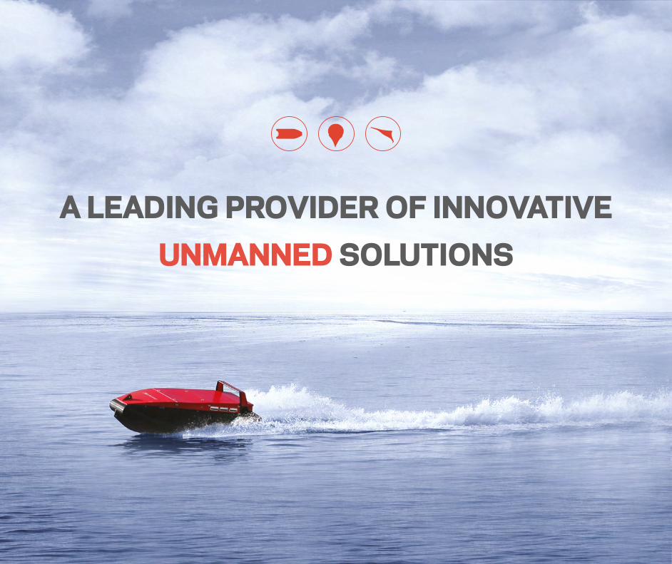
A LEADING PROVIDER OF INNOVATIVE UNMANNED SOLUTIONS

OUR SYSTEMS OPERATES UNMANNED IN THE AIR....Maritime Robotics is a leading provider of innovative Unmanned Vehicle Systems (UVS) for maritime operations in harsh environments.
Our Unmanned technologies and prod-ucts operate and collect data in the air, on the surface, and on the sea. Our products are within 3 main segments, Unmanned Aircraft Systems (UAS), Moored Balloon Systems (MBS) and Unmanned Surface Vehicles (USV).
With technology and products developed in cooperation with and on demand from civilian, governmental and military users, Maritime Robotics focuses on delivering high-quality system solutions and products that are cost-efficient, reduces HSE risk exposure and are highly deployable, in any conditions.
We believe that the future of maritime operations will enable more unmanned data acquisition, driving industry standards and broadening operational possibilities for these products.
Maritime Robotics´ headquarters are located in Norway’s technology capital Trondheim, staffed by a highly competent team of engineers and personnel. For our global clients and partners, our staff will at any time provide you with support and services, as well as assist you in finding the right solution for your maritime operations.
...AND ON THE SURFACE

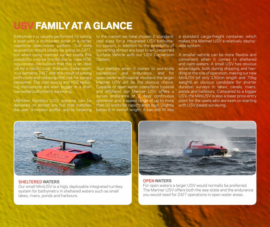
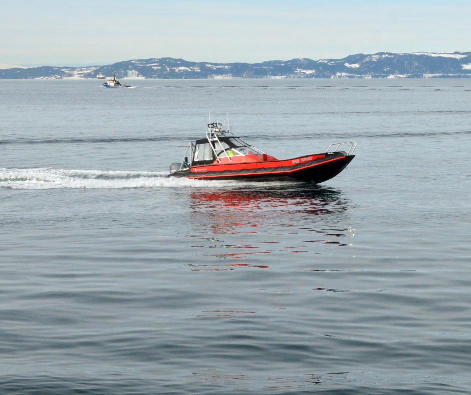
OPEN WATERSFor open waters a larger USV would normally be preferred. The Mariner USV offers both the sea-state and the endurance you would need for 24/7 operations in open water areas.
SHELTERED WATERSOur small MiniUSV is a higly deployable integrated turnkey system for bathymetry in sheltered waters such as small lakes, rivers, ponds and harbours.
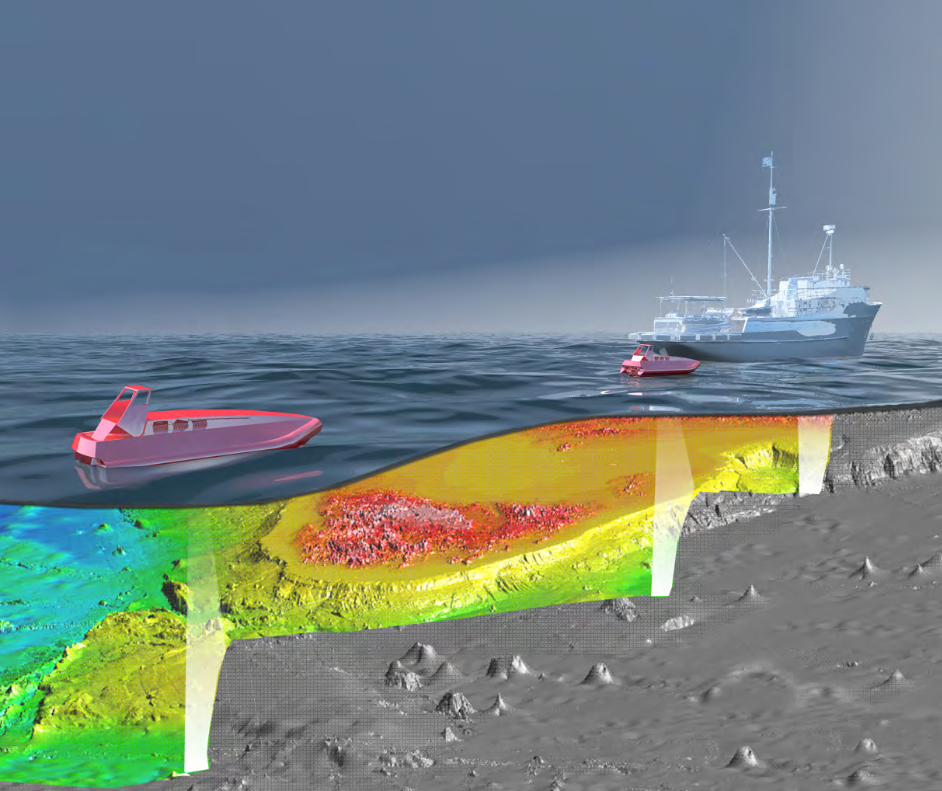
USV FAMILY AT A GLANCEBathymetry is usually performed by sailing a boat with a multibeam sonar in a rather repetitive lawn-mover pattern. The data acquisition should ideally be going on 24/7, but when using manned survey boats this possibility may be limited due to crew HSE regulations. We believe that this is an ideal job for a robotic boat, that sails these repet-itive patterns 24/7 with the result of saving both costs and reducing HSE risk for survey personnel. The cost-saving and HSE reduc-ing motivations are even bigger in a shal-low-water bathymetry surveying.
Maritime Robotics USV systems can be delivered on almost any hull that matches the user´s mission profile, and by listening
to the market we have chosen 2 standard-ized sizes for a integrated USV bathyme-try system, in addition to the possibility of converting almost any boat to an Unmanned Surface Vehicle with our USV Conversion System.
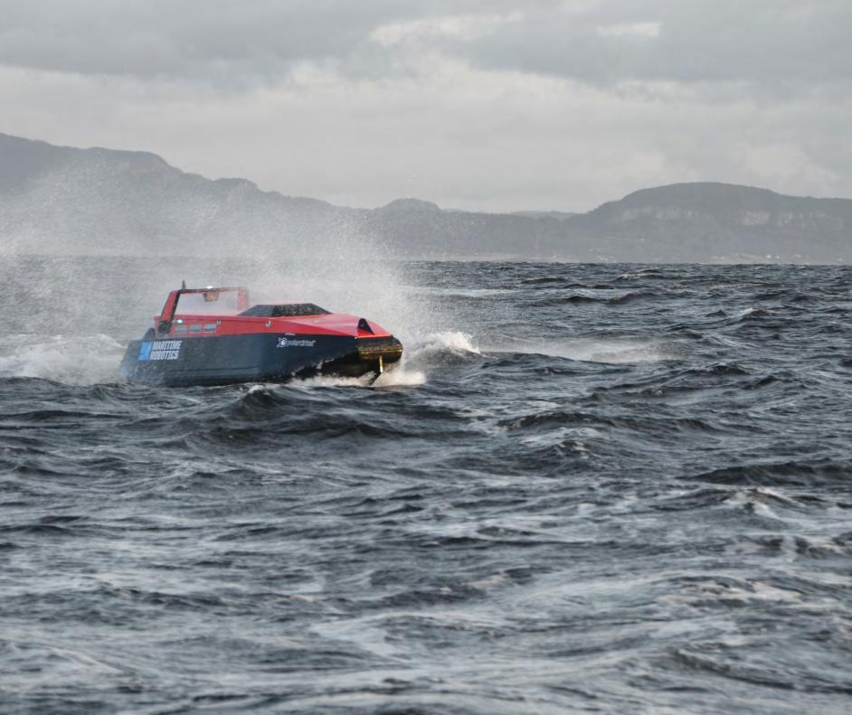
Size matters when it comes to sea-state capabilities and endurance, and for open-water and coastal missions the larger Mariner USV will be the obvious choice. Capable of open water operations (coastal and offshore) our Mariner USV offers a survey endurance of 2 days’ continuous operation and a speed range of up to more than 30 knots for rapid transit legs. Slightly below 6 m overall length, it can still fit into
a standard cargo-freight container, which makes the Mariner USV a relatively deploy-able system.
A smaller vehicle can be more flexible and convenient when it comes to sheltered and calm waters. A small USV has obvious advantages, both during shipping and han-dling at the site of operation, making our new MiniUSV (of only 150cm length and 70kg weight) an obvious candidate for shorter duration surveys in lakes, canals, rivers, ponds and harbours. Compared to a bigger USV, the MiniUSV is also a lower price entry point for the users who are keen on starting with USV based surveying.

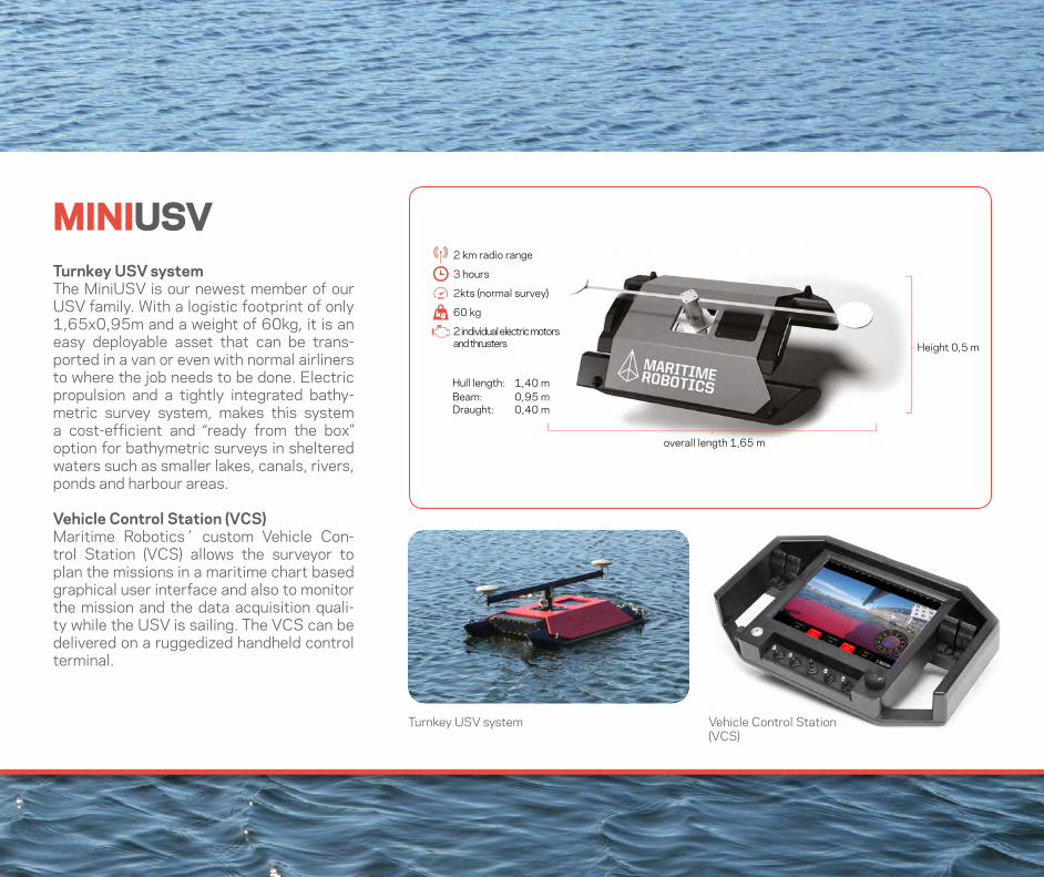
Turnkey USV systemThe MiniUSV is our newest member of our USV family. With a logistic footprint of only 1,65x0,95m and a weight of 60kg, it is an easy deployable asset that can be trans-ported in a van or even with normal airliners to where the job needs to be done. Electric propulsion and a tightly integrated bathy-metric survey system, makes this system a cost-efficient and “ready from the box” option for bathymetric surveys in sheltered waters such as smaller lakes, canals, rivers, ponds and harbour areas.
Vehicle Control Station (VCS)Maritime Robotics´ custom Vehicle Con-trol Station (VCS) allows the surveyor to plan the missions in a maritime chart based graphical user interface and also to monitor the mission and the data acquisition quali-ty while the USV is sailing. The VCS can be delivered on a ruggedized handheld control terminal.
MINIUSV
1 700 kg
50 hours + (5 kts)
> 30 knots max speed
Hamilton 241 waterjet
15 km range VHF/UHF radio. GPRS/Iridium (optional)
Volvo Penta D3 engine
EO/IR camera
Radar, CTD, ADCP, HPR
Echosounder & Sonars
Bow thruster proportional
Height 0,5 m
overall length 1,65 m
Hull length: 1,40 mBeam: 0,95 mDraught: 0,40 m
60 kg
3 hours
2kts (normal survey)
2 km radio range
2 individual electric motors and thrusters
Vehicle Control Station (VCS)
Turnkey USV system

Our Vehicle Control Station is created in coop-eration with industry designers. An important feature is the easy-setup and ergonomy.
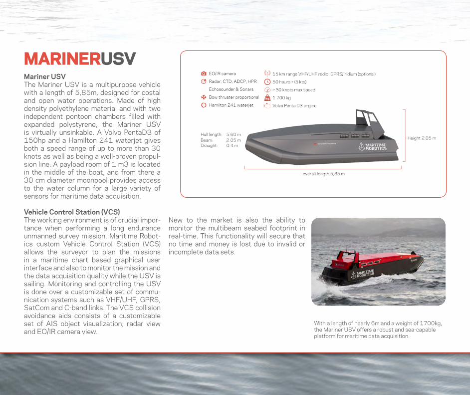
MARINERUSV
With a length of nearly 6m and a weight of 1700kg, the Mariner USV offers a robust and sea-capable platform for maritime data acquisition.
Mariner USVThe Mariner USV is a multipurpose vehicle with a length of 5,85m, designed for costal and open water operations. Made of high density polyethylene material and with two independent pontoon chambers filled with expanded polystyrene, the Mariner USV is virtually unsinkable. A Volvo PentaD3 of 150hp and a Hamilton 241 waterjet gives both a speed range of up to more than 30 knots as well as being a well-proven propul-sion line. A payload room of 1 m3 is located in the middle of the boat, and from there a 30 cm diameter moonpool provides access to the water column for a large variety of sensors for maritime data acquisition.
Vehicle Control Station (VCS)The working environment is of crucial impor-tance when performing a long endurance unmanned survey mission. Maritime Robot-ics custom Vehicle Control Station (VCS) allows the surveyor to plan the missions in a maritime chart based graphical user interface and also to monitor the mission and the data acquisition quality while the USV is sailing. Monitoring and controlling the USV is done over a customizable set of commu-nication systems such as VHF/UHF, GPRS, SatCom and C-band links. The VCS collision avoidance aids consists of a customizable set of AIS object visualization, radar view and EO/IR camera view.
New to the market is also the ability to monitor the multibeam seabed footprint in real-time. This functionality will secure that no time and money is lost due to invalid or incomplete data sets.

Some users want the option of using their survey boat in an unmanned mode, while still having the option of manned use. Oth-er users see a potential in using Unmanned Surface Vehicles, but are not yet ready to take the cost of investing in a custom USV platform. For those users the Maritime Robotics USV Conversion System offers a unique opportunity to take advantage of the possibilities for unmanned surface opera-tions.
The USV Conversion System includes the same Vehicle Control Station, Communica-tion and On-Board-Systems as the more in-tegrated Mariner USV system, but can also be highly customized for your special need and requirements.
For bathymetric survey we often see that many users have invested in custom-ized smaller manned survey boats. These users can now transform their boat into unmanned operations and thus achieving the HSE and cost-saving features of un-manned operation.
USV CONVERSION SYSTEM
The predecessor of the current Mariner USV was originally buillt around a converted PolarCirkel 560 with outboard engine.
Maritime Robotics has also converted conven-tional leisure crafts, such as this Viknes 830.
We have also converted military patrol-boats to unmanned operations. The conversion is normally done within 1-2 days.

For more than 5 years ago Maritime Robotics and the Norwegian University of Technology and Science (NTNU) demoed what we still claim was “the world´s first full-scale demo of unmanned formation con-trolled boats”. At that time, we clearly saw a potential, but did not yet have a clear view of all the possibilities this technology could open up for.
Since then, our internationally patented Formation Control System has been devel-oped into a ready-to-go product for users
who want to spread out sensor carrying boats over a larger water area, giving the possibility of controlling your fleet of multi-ple vessels like it was one single unit.
For multibeam bathymetry we have also improved the Formation Control System to use the information about the seabed foot-print of the multibeam as a direct guidance input for the formation. The surveyor can then decide the required multibeam over-lap that he wants, and then the Formation Control System takes care of the rest.
Our innovative Formation Control Sys-tem has been accepted with a US patent no.9151858 B2, EP patent no. 2198355 B1 and NO patent no. 327433.
FORMATION CONTROL
Maritime Robotics Formation Control System automatically adjusts the relative distance between the sensor carrying boats so that optimal coverage and no gaps in the dataset occurs.
Any existing bathymetry survey ship can be equipped with the Formation Control System, leading to great improvements in data collection per time unit.
The Formation Control System in use for shallow water bathymetry. The leader vessel typically sails over the shallowest part close to shore, and the unmanned ”slaves” then dynamically adapt their path for maximum efficiency.

NOTES
UNMANNED SYSTEMSCOST EFFICIENT AND RISK-REDUCING MARITIME DATA ACQUISITION
Brattørkaia 11 - Pirterminalen7010 Trondheim, Norway
+47 73 40 19 00www.maritimerobotics.com