university of groningen space syntax and volunteered
TRANSCRIPT

University of Groningen
Space syntax and volunteered geographic information for university campus planning anddesignMaciel de Brito Soares, Isabelle; Yamu, Claudia; Weitkamp, Gerd
Published in:Proceedings of the 12th International Space Syntax Symposium
IMPORTANT NOTE: You are advised to consult the publisher's version (publisher's PDF) if you wish to cite fromit. Please check the document version below.
Document VersionPublisher's PDF, also known as Version of record
Publication date:2019
Link to publication in University of Groningen/UMCG research database
Citation for published version (APA):Maciel de Brito Soares, I., Yamu, C., & Weitkamp, G. (2019). Space syntax and volunteered geographicinformation for university campus planning and design: Evidence from the Netherlands, Zernike CampusGroningen. In Proceedings of the 12th International Space Syntax Symposium (pp. 134.1–134.15).
CopyrightOther than for strictly personal use, it is not permitted to download or to forward/distribute the text or part of it without the consent of theauthor(s) and/or copyright holder(s), unless the work is under an open content license (like Creative Commons).
The publication may also be distributed here under the terms of Article 25fa of the Dutch Copyright Act, indicated by the “Taverne” license.More information can be found on the University of Groningen website: https://www.rug.nl/library/open-access/self-archiving-pure/taverne-amendment.
Take-down policyIf you believe that this document breaches copyright please contact us providing details, and we will remove access to the work immediatelyand investigate your claim.
Downloaded from the University of Groningen/UMCG research database (Pure): http://www.rug.nl/research/portal. For technical reasons thenumber of authors shown on this cover page is limited to 10 maximum.

Proceedings of the 12th Space Syntax Symposium
134
SPACE SYNTAX AND VOLUNTEERED GEOGRAPHIC INFORMATION FOR UNIVERSITY CAMPUS PLANNING AND DESIGN
Evidence from the Netherlands, Zernike Campus Groningen
ISABELLE SOARES University of Groningen [email protected] CLAUDIA YAMU University of Groningen [email protected] GERD WEITKAMP University of Groningen [email protected]
ABSTRACT The social, physical and psychological dimensions of wellbeing for public spaces between buildings and classrooms in university campus areas represent, for its users, multiple assemblages of material, cultural, emotional and social aspects (Atkinson, Fuller & Painter, 2012). There are a number of complexities that characterise the bonds between people-people and people-environment interactions, which are represented here by the possibilities of socialisation, sense of safety, stress relief and sense of belonging. Such possibilities should be considered in the design of the university campus public spaces, not only in cause of the continuous technological advancement, internationalisation and competitiveness, but also in order to achieve a healthy balance between work and recreational spaces. A variety of space syntax theories and methods have indicated with success the relationship between spatial configuration and pedestrian movement in diverse urban structures (Hillier et al., 1993; Hillier, Yang, & Turner, 2012; Sharmin & Kamruzzaman, 2018). Complementary to space syntax, VGI (Volunteered Geographic Information) participatory methods have helped researchers capture people’s perceptions of the environment representing it as geo-based information. Herein, a mixed-method approach involving space syntax analysis and VGI data collection through face-to-face interviews can be used as evidence for future campus planning and design. This experimental mixed-method was then applied to the case of Zernike Campus Groningen, in the Netherlands. The results obtained have shown that despite the fact that space syntax is very effective in forecasting pedestrian movement, the collected VGI data has the advantage of representing people’s perceptions and experiences of public spaces between buildings and classrooms. The results obtained in this paper found that there is a significantly low spatial correlation between pedestrian movement and the VGI data that the interviewees regarded as possible places of socialisation, sense of safety, stress relief and sense of belonging. The misfits in the correlation analysis contribute to our on-going investigation opportunities for critical reflection and further research; this includes the experimentation of another space syntax measures, modelling internal corridors in the campus and potential ways to collect VGI data.
Keywords: University campus design, wellbeing, volunteered geographic information (VGI), space syntax
1

Proceedings of the 12th Space Syntax Symposium
1. INTRODUCTION
The ongoing transformation of campus user needs and demands for research, teaching and learning is inevitably interwoven with the design of the campus. As a whole, university campus areas seem to experience changes in their social and spatial activities, as a result of technological development, internationalisation and competitiveness (den Heijer & Magdaniel, 2018; Magdaniel, 2016). The socio-spatial changes provoked by these processes should include the concept of wellbeing in order to enable creative activities. Previous research has shown that non-designated spaces, for instance public spaces at university campuses, play an important role in educational value as they contribute to the creation of a sense of community (Dugdale & Long, 2007). Marcus et al. (2016) adds that spatial composition can physically engage humans not only through locations for different physical activities and uses, but also mentally by providing opportunities for learning and creation of meaning. Therefore, in order to plan and design inclusive spaces, evidence-based design must address people-people and people-environment interactions to support the creation of public spaces that are capable of enhancing the wellbeing of its users. In this paper we address the concept of wellbeing as a positive state of people related to physical, social and psychological interactions.
Most Dutch science park campuses, such as Zernike Campus, adhere to the concept of modernism in a technical way in the sense that they separate humans and the environment they have built (Marcus et al., 2016). Such separations between humans and the environment in the modern era have shown undesirable side effects (Vining, 2003; Vining et al., 2008; Marcus et al., 2016). These side effects are the design of the public space network, which was implemented as an independent infrastructure from the immediate urban context (Magdaniel, 2016). Consequently, the lack of holistic logic between buildings and classrooms has meant that the important role of university public spaces for creating wellbeing and a sense of community has been ignored; thus, the full potential for creative activities has not yet been achieved. The design of the public spaces as an independent infrastructure also impacts the research, teaching and learning. Most importantly, the design often affects the development of attractive places that promote a balance between work and recreational spaces, since a healthy working and studying environment tend to decrease the feeling of stress (Schewenius et al., 2017).
Since the 1980s, Space Syntax as a syntactical analysis has demonstrated with success the relationship between spatial structure and movement (Hillier et al., 1993). However, what the analysis fails to incorporate is the multiple features of physical, social and psychological wellbeing, which cannot only be assessed only through syntactical analysis. This is because these aspects are ignored when abstracting the street section to an axial line and consequently the analysis neglects the people-people and people-environment interactions. Space syntax lines of movement do not take into account perceptual properties, as it only considers the way they connect to each other (Ratti, 2004; Pafka et al., 2018). Therefore, combining the space syntax method with Volunteered Geographic Information (VGI) enables the researcher to explore the user’s experiences and perceptions. VGI is a form of collaborative mapping that allows campus users to have a more active role in urban planning and design activities (Poplin et. Al, 2018; Goodchild, 2007).
Until now, the tools that have been developed to objectively assess wellbeing have taken into consideration spatial network properties, measures derived from primary field surveys (normally census-based), data sets and even the combination of multiple sources (Pacione, 2003). However, mixed-models that capture the user’s possibilities of movement (axial maps) and perceptual aspects of the environment (VGI), have not quite yet been explored. Importantly, the participatory data represented by VGI, considers both the city on the ground and the city in the mind. In other words, the combination of methods supports a holistic approach, taking into consideration activities location and perceptual attributes.
With this mixed-method approach, we contribute to the demand to grasp the complex relationships between spatial structure and people’s perceptions. In addition, this study aims to understand how a mixed-method approach can be used as evidence-based design tool for social, physical and psychological wellbeing of university campus areas. We contribute to space syntax studies by adding a complementary collaborative method (VGI) in order to link people’s perception to the distribution of movement through the street network. This meaningful combination of methods and therefore set of techniques, can be informative of how the spatial relationships represented as networks can relate to functional patterns such as movement or wellbeing.
2
Proceedings of the 12th Space Syntax Symposium
This article is divided into five parts. Firstly, following the introduction, in section 2 we give a literature overview that provides a synopsis of the space syntax application for university campuses, its limitations and the importance of complementary collaborative methods in an attempt to compensate for the limitations of the space syntax method. The importance of social, physical and psychological wellbeing for university campus planning and design is thus expounded. Secondly, in section 3, we describe the datasets and method that have been incorporated. Thirdly, under results in section 4, we apply and interpret the results of our case study at Zernike Campus in Groningen, the Netherlands. Finally, in section 5 we conclude the consolidation of the obtained results.
2. LITERATURE OVERVIEW
Space syntax is characterised by a set of theories and methods used for modelling and analysing cities, in which space is the fundamental generator of the city (Karimi, 2018). Space syntax consists of calculating configurative spatial relationships – cities as networks of space – in the built environment. It requires a set of techniques for observing how these networks of space relate to functional patterns, such as movement, land use, area differentiation, migration patterns and even social wellbeing and malaise (Aleksandrowicz, van Nes & Yamu, 2018).
In the field university campus planning and design, space syntax has been broadly used in diverse investigations such as the use of public spaces for the impact of spatial structure, the flow of technology focusing on students’,academic interactions and subjective perceptions (Greene & Penn, 1997), the relationship between campus life and collective spaces (Yaylali-Yildiz et al., 2013), socio-spatial aspects of informal learning (Wu et al., 2017), the location choices of “power places”, places that evoke positive feelings and place-making for a synthesis (Poplin et al., 2018).
In order to understand how to integrate wellbeing in university planning and design, we have to comprehend the concept of wellbeing and how it is linked to the built environment. Wellbeing is related to both positive or negative experiences that have developed over time, sometimes occurring without awareness (Brown & Perkins, 1992). Conradson defines wellbeing as a “holistic conception of positive human functioning” and “explicitly positive concept, in that it describes the presence of positive qualities and experiences rather than simply the absence of illness and disease” (Conradson, 2012, p.16). For the World Health Organization (WHO) (1997), wellbeing is compared as “quality of life”. The definition of “quality of life” is an expansive notion, which is affected in a complex way by the person’s physical health, psychological state, personal beliefs, social relationships and their relationship to salient features of their environment (World Health Organization, 1997).
Wellbeing has no form, expression or improvement without the consideration of place. The process of wellbeing or becoming, whether it is enjoying a balance between positive and negative effects, fulfilling potential, expressing autonomy or mobilising a range of material, social and psychological resources, is essentially and necessarily emergent in a place (Atkinson, Fuller & Painter, 2012). Therefore, a sense of place and place attachment have been classified by Eyles & Williams (2008) with three overlapping dimensions regarding wellbeing: 1) physical, e.g. the buildings, street network and open spaces (including green areas); 2) social, e.g. density of interactions between people and local institutions and 3) psychological, e.g. identity and attachment to the physical and or social attributes of the locality. Thus, a sense of place involves and interprets the perception of the environment and an emotional reaction to said environment (Hummon, 1992).
So, why are social, physical and psychological aspects of wellbeing important for university campus planning and design? It is because university campus areas are not mere container of experiences rather they are part of people’s lived experiences. These experiences enable sense of place that can be measured as rootedness, belonging, place identity, meaningfulness, place satisfaction, emotional attachment and physical environmental dimensions (Hummon, 1992). Such experiences, between people-people and people-environment in spaces between buildings and classrooms, have the power to enable knowledge-based and social activities. Thus, the possibility of sharing responsibilities and mutual support through social networks generates a feeling of belonging and security (Relph, 2016).
The complexities of social, physical and psychological wellbeing are understood as multiple assemblages of material, cultural, emotional and social constituting meaningful sites of living and encounter (Atkinson, Fuller & Painter, 2012). In an attempt to represent people’s perceptions regarding these assemblages, we assume that university campus’ public spaces between buildings and classrooms must allow possibilities of socialisation, a sense of safety, stress relief and a sense of belonging Yaylali-
3

Proceedings of the 12th Space Syntax Symposium
(Yildiz et al., 2014). Such possibilities correspond to the continuous transformation of campuses due to digitalisation (availability of information online), internationalisation and the increasing demand of careers with multidisciplinary skills. Technological transformations are not only changing user’s demands but also the way we engage with the campus community in the design process.
One important method to assess spatial relationships between spatial configuration and their effects on people’s wellbeing is Public Participatory Geographic Information Systems (PPGIS). PPGIS refers to spatially explicit methods and technologies that uses spatial information in processes of participatory planning and design (Brown & Fagerholm, 2015). Such spatial data can be collected and furthermore stored and analysed by digital mapping technologies. The general concept of “participatory mapping” can describe any process whereby individuals share the creation of a map and would include the concept of VGI. Goodchild (2007) explains that while collecting VGI of perceptual data, citizens act as sensors directly immersed in the situation where changes in the environment can be observed in a place-based scale and with local knowledge. In a VGI environment, the data can be stored just as GIS and can be related with other attributes, describing the characteristics of the subjects. The application of data collection through VGI can be offered on a PC or on mobile devices such as smart phones and tablets (Poplin et al., 2018).
The combination of VGI and space syntax methods have proven to be very efficient in understanding the implications of the spatial structure and people’s emotional reaction to spatial environment (Poplin et al., 2018). Insights about the built environment and its spatial possibilities (of socialisation, sense of safety, stress relief and sense of belonging) can be evidence for wellbeing in future campus planning and design. Thus, the combination of methods contributes to research debate involving space syntax and GIS Sciences, specifically on how to explore objectively people’s perceptions through VGI data.
3. DATASETS AND METHODS In order to answer the research question, we applied a combined method to address social, physical and psychological wellbeing for Zernike Campus Groningen. Our research method consisted of two parts: (a) a computational analysis using space syntax theories and method and (b) VGI data collection with face-to-face interviews through a web-based questionnaire. The empirical data represents people’s perceptions regarding the possibilities for socialisation, a sense of safety, stress relief and a sense of belonging. After gathering the two datasets, we combined, correlated and analysed how pedestrian movement related to such possibilities and how the mixed-method could be used as evidence for university campus wellbeing.
The mathematical street network model for the computational analysis was modelled based on OpenStreetMap (OSM) using the method of an axial map taking into consideration formal pedestrian paths and more specifically lines of movement. We conducted normalised angular integration (NAIN), normalised angular segment analysis of Choice (NACH). We applied the city-wide radius N and a local radius with 500m. Both measures have proven to show a consistent relationship with pedestrian movement (Sharmin & Kamruzzaman, 2018) because people tend to estimate the angular distance to reach a destination while walking through a neighbourhood (Hillier, 2009). In mathematical terms, NACH represents “betweeness” (trough movement) and NAIN represents “closeness” (to-movement).
Considering evidence from the meta-analysis of Sharmin & Kamruzzaman (2018), the NACH measures possessed the strongest and most consistent correlation with pedestrian movement compared to other conventional syntactic measures, such as integration (Al_Sayed, Turner, & Hanna, 2012; Hillier, Yang, & Turner, 2012; Sharmin & Kamruzzaman, 2018). Therefore, we gave special attention to NACH in the neighbourhood scale, since its values were relatively independent of network size (Hillier et al. 2009) and favoured the co-presence of different types of people (Legeby, 2013).
To complement the syntactical analysis, NACH was correlated with the collected empirical data, and the results were juxtaposed with VGI perceptual data for wellbeing. The empirical data was collected using the web-based application Maptionnaire (maptionnaire.com). The questionnaire addressed user’s interpretive perception of the environment and reactions to that environment. Such interpretive and perceptual aspects were the variables of possibilities of socialisation, a sense of safety, stress relief and a sense of belonging. Table 1 presents the definition of each one of the questions. For our data collection, we applied the ethical and data protection protocols of our institution.
4
Proceedings of the 12th Space Syntax Symposium
Questionnaire concept related to wellbeing Socialisation To create and foster a learning community in the campus (Chapman, 1999, 2006). Sense of safety Being co-present in public space and watching other people; one can produce the global
phenomenon of safety (Jacobs 1961), the notion of ‘eyes on the street’. Stress relief Meaningful encounters between people and contact with green spaces in public are are
beneficial for wellbeing since they provide relief from daily routines (Cattel et. al 2008).
Sense of belonging
Being part or being attached to a place "involves positively experienced bonds, that are developed over time between individuals and or groups and the socio-physical environment” (Brown and Perkins, 1992)
Table 1: Perceptual aspects of the environment
We conducted face-to-face interviews with 160 users including students, employees and visitors from diverse institutions (academic and not academic), during the weekdays in April 2018. To indicate how people perceive the spaces at the campus, the interviewees were asked to draw polygons where they felt there were possibilities for socialisation, a sense of safety, stress relief and a sense of belonging (Yaylali-yildiz et al., 2014). The data collected was a pilot study with an in-class experiment. Students who collected the data focused on the southern part of Zernike where all the academic institutions are located. This limitation was not set but appeared to the students naturally as this is the area of the campus they know and where the social activities take place.
VGI enabled reporting perceptual aspects of the environment, since the interviewee contributed with their own knowledge. The VGI data enters the system and is stored in vector format in a geographic database (Poplin et. al, 2017). The advantages of using Maptionnaire are that it enables the creation of web-based questionnaires with user-friendly interfaces providing the interviewees with multiple possibilities to report geographical referenced and map-based perceptions. When entered in a geographical database, the data can be used for a variety of spatial analysis, spatial queries and statistics. The questions were inspired by Yaylali-Yildiz et al. (2014) (Table 2):
Face-to-face interview questionnaire Socialisation Question 1:
Name and indicate on the map the open public space that provides the possibility of socialisation.
Sense of safety
Question 2: Name and indicate on the map the open public space that makes you feel safe the most (e.g. when walking at night).
Stress relief Question 3: Name and indicate on the map the open public space you feel relief from daily problems.
Sense of belonging
Question 4: Name and indicate on the map the open public space that makes you feel as an university student/employee.
Table 2: Questionnaire of the four perceptual aspects of open and public spaces
The correlation of the two aforementioned datasets was developed as follows. Firstly, we created an overall visualisation of the combined data of lines of movement (NACH 500m radii) with the VGI data for each question (socialisation, sense of safety, stress relief and sense of belonging). Secondly, we translated the NACH values into points using GIS because it could represent a clearer visualisation of the values distribution along the segments, thus facilitating the correlation with the VGI data. Such points were generated specifically in the area that “touched” the polygons that represented the four aforementioned questions. In other words, we determined a boundary, leaving the northern part of the campus out of the linear regression analysis due to lack of data collected in that area. Finally, we generated scatterplots to investigate the correlation between pedestrian movement and the real use of the spaces reported by the interviewees (see figure 4).
5

Proceedings of the 12th Space Syntax Symposium
4. RESULTS
4.1. CASE STUDY
Zernike Campus is located in Groningen, which is a university city in the North of the Netherlands. Academic institutions have always been part of its spatial development since 1600. Groningen is a mix between “town and gown” (Zillich, 2018). The main university buildings and a number of departments are scattered across the city centre, whereas Zernike Campus is constituted as a science park and is located on the edge of the city, characterised as an autonomous urban fabric (Magdaniel, 2016; Da Silva & Heitor, 2017; Da Silva et al., 2017). Zernike Campus was established in the late 1960s because of the need for a separated (or even isolated) space for the natural sciences for research and educational purposes. Such a separation was a very common reality in European cities around that time. Science parks were designed and implemented from scratch reproducing the logic of ‘life enclosed to buildings’. This logic is a repetition of the initial concept of European universities, which are typically cloistered and inward-looking (Gumprecht, 2009).
Zernike Campus’ spatial configuration can be described as a “pattern free” set of buildings in a green area, organised and “isolated” by a loose and maxi grid of high-speed arteries with different shapes. This design, common in modernistic science parks, often separated humans and the built environment in a technical way (Marcus et al., 2016). The spatial structure is a discontinuous street pattern and (almost) closed road network, which functions independent from the rest of the city context. Thus, public spaces between buildings and classrooms as a potential for enhancing wellbeing and creativity were not taken into consideration during the planning and mapping of the campus.
Figure 1 depicts the location of Zernike Campus and Figure 2 presents its land use. The campus land use is divided into the southern part, which is predominantly occupied by academic institutions (University of Groningen (RUG) and Hanze University of Applied Sciences) and the northern part, where knowledge-intensive and research-based companies are located. This spatial distribution already suggests a division of activities and therefore does not allow the potential for a mixed land use approach. Such loss of potential also superimposes the public spaces.
Figure 1: Groningen & Zernike Location
6

Proceedings of the 12th Space Syntax Symposium
Figure 2: Zernike Campus spatial layout including landuse.
4.1. ANALYTICAL RESULTS
The syntactical analysis was carried out using the DepthmapX 0.50 software (Varoudis, 2015). The integrated values are represented graphically in the axial map, using a scale of colours that range from red referring to highly integrated streets, to blue referring to the segregated streets. Figure 3 summarises the segment angular analysis featuring both global and local integration (NAIN Rn and NAIN 500m), as well as global and local choice values (NACH Rn and NACH 500m).
The NAIN N and NAIN 500m analysis highlights the spatial “spine”, which are Zernikelaan and the main distributors Kadijk and De Mudden (Figure 3); also, Zernikeplein as a public space has high values (see Figure 3, Table 3). In addition, for NAIN 500m the analysis also depicted De Deimten street. We found similar results for the NACH analysis. The NACH RN and NACH 500m analysis depicted high values for Zernikelaan, Zernikeplein, Blawborgje, Kadijk and De Mudden. For NACH 500m, which is equivalent to a 6 minutes walk, the highest values (Table 3) were found at De Deimten, Landleven, Kadijk and De Mudden. Furthermore, in the south of the Zernike Campus, the streets around the Mercator building (Faculty of Spatial Sciences) have high values, namely Blauwborgje, Landleven and Nettelbosje.
In summary, for cities where high integration values overlap with high choice values, a vital economic self-organisation takes place. This does not hold for the campus area as it is an artificially built environment.
7

Proceedings of the 12th Space Syntax Symposium
Figure 3: (a) NAIN Rn; (b) NAIN 500m; (a) NACH Rn; (b) NACH 500m of Zernike Campus
NAIN Rn NAIN 500m NACH Rn NACH 500m
System min. 2.498 2.451 - - System mean 2.858 2.930 0.564 0.575 System max. 3.291 4.465 1.567 1.702 01. De Mudden Street 3.195 3.356 1.463 1.406 02. Kadijk Street 3.213 3.286 1.449 1.322 03. Zernikeplein Street 3.201 3.201 1.344 1.308 04. Kapteynborg Building - - - - 05. Blawborgje Street 3.158 3.091 1.505 1.185 06. Landleven Street 3.052 3.175 1.385 1.414 07. Duisenberg Building - - - - 08. Zernikelaan Street 3.131 3.222 1.479 1.295 09. Mercator Building - - - - 10. Aletta Exam Hall - - - - 11. De Deimten Street 3.090 3.444 1.388 1.453 12. Supermarket - - - - 13. Nijenborgh Street 3.058 3.124 1.350 1.337 14. Energy Academy
Building - - - -
15. Nettelbosje 2.920 3.118 1.298 1.361
Table 3: Syntactical measures of key locations at Zernike Campus, Integration (NAIN) and Choice (NACH) Analyses
8

Proceedings of the 12th Space Syntax Symposium
As a result of the circumstances mentioned above (see section on datasets and methods), we have a rich dataset for the southern part of the campus but we lack data for the northern part of the campus where companies are located. Therefore, we only addressed the VGI data in the southern part of the campus. In Figure 4, we superimposed our space syntax analysis with the data from our questionnaire. This also added information on how participants mostly involved in academic activities perceive the campus area. The northern part, for most students and academic employees was not perceived as an integral part. In Figure 4, the pink colour represents the number of polygons drawn by the interviewees in Maptionnaire, where the darker the colour was the higher the possibilities of socialisation, sense of safety, stress relief and sense of belonging (see also colour key). Thus, the boundary line specifies the area that we applied for the linear regression analysis (Figure 7).
Figure 4: Normalised Angular Choice (500m) superimposed with VGI data for wellbeing
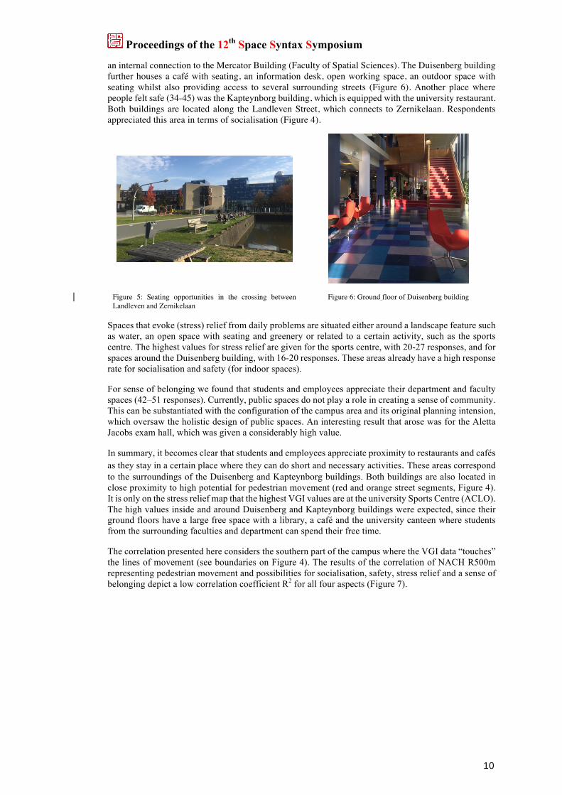
and boundary line determining area for correlation analysis In terms of socialisation, the participants mostly indicated areas close to restaurants and where seating opportunities were available inside and outside. They also signposted the only supermarket that there was on campus. One of the popular spaces for socialising was next to the water feature where Landleven Street connects with Zernikelaan. Further, the sports centre and the football field were also indicated as places where socialisation was possible. For Zernike Campus, socialisation was mostly linked to land use, landscape features and most important seating opportunities (example in Figure 5). This is also why there is a public transport stop nearby.
Regarding safety, the response shows that campus users feel safest inside one of the main buildings; namely the Duisenberg building with 34-50 responses (Figure 1). It hosts the Faculty of Economy with
9
Proceedings of the 12th Space Syntax Symposium
an internal connection to the Mercator Building (Faculty of Spatial Sciences). The Duisenberg building further houses a café with seating, an information desk, open working space, an outdoor space with seating whilst also providing access to several surrounding streets (Figure 6). Another place where people felt safe (34-45) was the Kapteynborg building, which is equipped with the university restaurant. Both buildings are located along the Landleven Street, which connects to Zernikelaan. Respondents appreciated this area in terms of socialisation (Figure 4).
Figure 5: Seating opportunities in the crossing between Landleven and Zernikelaan
Figure 6: Ground floor of Duisenberg building
Spaces that evoke (stress) relief from daily problems are situated either around a landscape feature such as water, an open space with seating and greenery or related to a certain activity, such as the sports centre. The highest values for stress relief are given for the sports centre, with 20-27 responses, and for spaces around the Duisenberg building, with 16-20 responses. These areas already have a high response rate for socialisation and safety (for indoor spaces).
For sense of belonging we found that students and employees appreciate their department and faculty spaces (42–51 responses). Currently, public spaces do not play a role in creating a sense of community. This can be substantiated with the configuration of the campus area and its original planning intension, which oversaw the holistic design of public spaces. An interesting result that arose was for the Aletta Jacobs exam hall, which was given a considerably high value.
In summary, it becomes clear that students and employees appreciate proximity to restaurants and cafés as they stay in a certain place where they can do short and necessary activities. These areas correspond to the surroundings of the Duisenberg and Kapteynborg buildings. Both buildings are also located in close proximity to high potential for pedestrian movement (red and orange street segments, Figure 4). It is only on the stress relief map that the highest VGI values are at the university Sports Centre (ACLO). The high values inside and around Duisenberg and Kapteynborg buildings were expected, since their ground floors have a large free space with a library, a café and the university canteen where students from the surrounding faculties and department can spend their free time.
The correlation presented here considers the southern part of the campus where the VGI data “touches” the lines of movement (see boundaries on Figure 4). The results of the correlation of NACH R500m representing pedestrian movement and possibilities for socialisation, safety, stress relief and a sense of belonging depict a low correlation coefficient R2 for all four aspects (Figure 7).
10

Proceedings of the 12th Space Syntax Symposium
Figure 7: Correlation of NACH R500m with VGI data of people’s perception.
The low correlation coefficient for all aspects confirms our problem statement about space syntax limitations. As mentioned in the introduction, syntactical lines do not take into account perceptual properties, rather they consider the way spaces connect to each other. For Zernike Campus area, potential through movement (NACH 500m) in terms of walkability has little to do with how people perceive the southern campus area (Figure 7). How people see possibilities to spend their time in the campus’ public spaces seems to be independent of how people perceive space. The highest correlation value was found for sense of belonging R2 = 0.011 and the lowest correlation was for safety with a value of R2 = 0.001. The rationale for the low correlation for safety is related to the face that people feel safest inside certain buildings. The axial map of the campus area does not take into consideration indoor movement; therefore, a holistic axial model incorporating public spaces both indoor and outdoor might lead to different results. Even though we determined the boundary for the correlation focusing on the southern part of the campus, lines of movement in the open public spaces did not determine how people perceived the environment. Therefore, we have identified a methodological challenge that need further testing for validation and consolidation in future studies. Nevertheless, in Figure 4, where the data was graphically superimposed, we can visually identify a partially high correlation of high NACH R500m values and perceptions in certain areas. This especially holds true for the streets around Duisenberg building and close to the water feature (Figure 2); namely ACLO (regarding socialisation and stress relief).
11

Proceedings of the 12th Space Syntax Symposium
5. CONCLUSIONS
This paper summarises our ongoing research that tries to answer how spatial configuration and people’s perception of the environment can be evidence to achieve social, physical and psychological wellbeing when planning and designing a campus. We applied a combined method using space syntax and VGI to understand pedestrian movement and people’s perceptions. We addressed user’s perception through VGI to represent the possibilities of socialisation, sense of safety, stress relief and sense of belonging. Although the overall correlation analysis shows very low relation between movement and perceptual data, the surroundings of Duisenberg and Kapteynborg have shown high potential for movement. Further, quite a high number of respondents seem to have some form of attachment to these places.
We conclude that the mixed-method approach applied in this paper has misfits, showing three main opportunities for further research. Firstly, the mixed-method approach needs a critical reflection for further testing on how other space syntax measures could be explored when combined with VGI data. For instance, exploring the relationship between Visibility Graph Analysis (VGA) and VGI. Secondly, there was also a necessity to develop a holistic syntactical model that incorporated both inside and outside paths, such as passages on the ground floor. Moreover, people’s activities inside and outside buildings do not only depend on the spatial configuration but also environmental conditions such as climate. Finally, we also noticed the need to collect additional data, mainly in the northern area of the campus, since there are a variety of other activities, especially at the Hanze School of Applied Sciences and companies located around the streets of De Mudden and Kadijk.
Through the results, it became evident that that people tend to see possibilities close to the places they are familiar with and areas that are easy to reach in terms of accessibility. Socialisation, sense of safety, stress relief and sense of belonging were noticed to be related to the density and diversity of activities. The current spatial and organisational structure, where buildings are specialised and isolated objects, reflects on the users’ perceptions of the environment and on the use of public spaces. In other words, people do not seem to explore the campus to its full potential. Through the results it became clear that in the case of Zernike, there is room for improvement in blurring spatial lines between faculties, and in the attempt to find a balance between work and leisure through the design of the campus.
12

Proceedings of the 12th Space Syntax Symposium
REFERENCES
Al_Sayed, K., Turner, A. and Hanna, S., 2012, January. Generative structures in cities. In Proceedings of the 8th International Space Syntax Symposium.
Aleksandrowicz, O., Yamu, C. and van Nes, A., 2018. Spatio-Syntactical Analysis and Historical Spatial Potentials: The Case of Jaffa–Tel Aviv. Journal of Interdisciplinary History, 49(3), pp.445-472.
Atkinson, S., Fuller, S. and Painter, J., 2012. Wellbeing and place (pp. 1-14). Farnham: Ashgate.
Brown, B.B., Perkins, D.D., 1992. Disruptions in place attachment. In: Altman, I., Low, S.M. (Eds.), Place Attachment. Plenum, New York.
Brown, G. and Fagerholm, N., 2015. Empirical PPGIS/PGIS mapping of ecosystem services: a review and evaluation. Ecosystem Services, 13, pp.119-133.
CATTELL, Vicky, DINES, Nick, GESLER, Wil, et al. Mingling, observing, and lingering: Everyday public spaces and their implications for well-being and social relations. Health & place, 2008, vol. 14, no 3, p. 544-561.
Chapman, M.P., 1999. The Campus at the Millennium: A Plea for Community and Place. Planning for Higher Education, 27(4), pp.25-31.
Chapman, M.P., 2006. American places: In search of the twenty-first century campus. Greenwood Publishing Group.
Conradson, D., 2012. Wellbeing: Reflections on geographical engagements. Wellbeing and place, pp.15-34.
Da Silva, l.c., Heitor, t.v. And Calvo-Sotelo, p.c., 2017. How exclusive do we want to be? Exploring the University Realm in the Contemporary Urban Territory. In Proceedings of the 11th International Space Syntax Symposium, Lisbon, iv-1–12. Retrieved from http://www.11ssslisbon.pt/docs/book-proceedings-29032018.pdf
DA SILVA, Luísa Cannas; HEITOR, Teresa Valsassina. Campuses as Sustainable Urban Engines—A Morphological Approach to Campus Social Sustainability. In: Handbook of Theory and Practice of Sustainable Development in Higher Education. Springer International Publishing, 2017. p. 259-276.
den Heijer, A.C. and Magdaniel, F.T.C., 2018. Campus–City Relations: Past, Present, and Future. In Geographies of the University (pp. 439-459). Springer, Cham.
Dugdale, S., & Long, P. (2007). Planning the Informal Learning Landscape. ELI Webinar, 12.
Eyles, J. and Williams, A. eds., 2008. Sense of place, health and quality of life. Ashgate Publishing, Ltd..
Greene, M. and Penn, A., 1997. Socio-spatial analysis of four University Campuses: the implications of spatial configuration on creation and transmission of knowledge.
Goodchild, M.F., 2007. Citizens as sensors: the world of volunteered geography. GeoJournal, 69(4), pp.211-221.
Hillier, B., Penn, A., Hanson, J., Grajewski, T. and Xu, J., 1993. Natural movement: or, configuration and attraction in urban pedestrian movement. Environment and Planning B: planning and design, 20(1), pp.29-66.
13

Proceedings of the 12th Space Syntax Symposium
Hillier, B., Turner, A., Yang, T. and Park, H.T., 2009. Metric and topo-geometric properties of urban street networks: some convergences, divergences and new results. Journal of Space Syntax Studies.
Hummon, D. H., D. M.M. (1992) 'Community attachment: local sentiment and sense of palce', in Altman, I. & Low, S. M. (eds.) Place attachment. New York: Plenum Press.
Jacobs, Jane. The death and life of American cities. 1961
KARIMI, Kayvan. Space syntax: consolidation and transformation of an urban research field. 2018.
Legeby, A. (2013). Patterns of co-presence: Spatial configuration and social segregation (Doctoral dissertation, KTH Royal Institute of Technology).
MAGDANIEL, Flavia Teresa de Jesús Curvelo. Technology campuses and cities: A study on the relation between innovation and the built environment at the urban area level. A+ BE| Architecture and the Built Environment, 2016, no 12, p. 1-476.
Marcus, L., Giusti, M. and Barthel, S., 2016. Cognitive affordances in sustainable urbanism: contributions of space syntax and spatial cognition. Journal of Urban Design, 21(4), pp.439-452.
Pacione, M., 2003. Urban environmental quality and human wellbeing—a social geographical perspective. Landscape and urban planning, 65(1-2), pp.19-30.
Pafka, E., Dovey, K. and Aschwanden, G.D., 2018. Limits of space syntax for urban design: Axiality, scale and sinuosity. Environment and Planning B: Urban Analytics and City Science, p.2399808318786512.
Poplin, A., Yamu, C. and Rico-Gutierrez, L., 2017. Place-making: an approach to rationale behind the location choice of power places. University campus Ames as a case study.
Ratti, C., 2004. Space syntax: some inconsistencies. Environment and Planning B: Planning and Design, 31(4), pp.487-499.
RELPH, Edward. Senses of place and emerging social and environmental challenges. In: Sense of place, health and quality of life. Routledge, 2016. p. 51-64.
SHARMIN, Samia et KAMRUZZAMAN, Md. Meta-analysis of the relationships between space syntax measures and pedestrian movement. Transport Reviews, 2018, vol. 38, no 4, p. 524-550.
Schewenius, M., Keränen, P. and al Rawaf, R., 2017. Dreams and Seeds: The role of campuses in sustainable urban development. Stockholm Resilience Centre och Metropolia University of Applied Sciences.
Vining, J. 2003. “The Connection to Other Animals and Caring for Nature.” Human Ecology Review 10: 87–99. doi:http://dx.doi.org/10.2307/3802153.
Vining, J., M. S. Merrick, and E. A. Price. 2008. “The Distinction between Humans and Nature: Human Perceptions of Connectedness to Nature and Elements of the Natural and Unnatural.” Human Ecology Review 15 (1): 1–11. http://biophiliccities.org/wp-content/uploads/2012/06/ DistinctionBetweenHumansNature.pdf.
Zillich, C., 2018. Coevolution of Town and Gown: The Heidelberg International Building Exhibition in Search of a Knowledge-based Urbanism for the Twenty-first Century. In Geographies of the University (pp. 461-475). Springer, Cham.
14

Proceedings of the 12th Space Syntax Symposium
YAYLALI-YILDIZ, Berna, CZERKAUER-YAMU, Claudia, et ÇIL, Ela. Exploring the effects of spatial and social segregation in university campuses, IZTECH as a case study. Urban Design International, 2014, vol. 19, no 2, p. 125-143.
Varoudis, T. (2015), ‘DepthmapX – Multi-platform Spatial Network Analyses Software’. Avaiable at: <https://github.com//varoudis/depthmapX>.
World Health Organization. (1997). WHOQOL Measuring Quality of Life. Geneva: World Health Organisation.
Wu, x., Law, s., Heath, t. and Borsi, k., Spatial configuration shapes student social and informal learning activities in educational complexes. In Proceedings of the 11th International Space Syntax Symposium, Lisbon, iv-1–12. Retrieved from http://www.11ssslisbon.pt/docs/book-proceedings-29032018.pdf
15