united states department of the interior u.s. …
TRANSCRIPT

UNITED STATES DEPARTMENT OF THE INTERIOR U.S. GEOLOGICAL SURVEY
Geology and Hydrocarbon Resources of Onshore Basins in Eastern China
byGregory Ulmishek*
c U.S. Geological Survey
Open-File Report 93-4
This report is preliminary and has not been reviewed for conformity with U.S. Geological Survey editorial standards (or with the North American Stratigraphic Code). Any use of trade, product or firm names is for descriptive purposes only and does not imply endorsement by the U.S. Government.
1 Denver, Colorado
1992
CONTENTSPage
Purpose and Scope of Study..................................................................................... 1Ordos Basin
Introduction................................................................................................................. 3Stratigraphy.................................................................................................................. 3Tectonics....................................................................................................................... 16Petroleum Geology and Potential Exploration Plays.......................................... 17
Sichuan BasinIntroduction................................................................................................................. 29Stratigraphy.................................................................................................................. 29Tectonics....................................................................................................................... 40Petroleum Geology and Potential Exploration Plays.......................................... 44
Songliao Basin....................................................................................................................... 47Introduction................................................................................................................. 47Stratigraphy.................................................................................................................. 47Tectonics....................................................................................................................... 51Petroleum Geology and Potential Exploration Plays.......................................... 57
North China BasinIntroduction................................................................................................................. 65Stratigraphy.................................................................................................................. 65Tectonics....................................................................................................................... 72Petroleum Geology and Potential Exploration Plays.......................................... 73
Nanxiang BasinIntroduction................................................................................................................. 99Stratigraphy.................................................................................................................. 99Tectonics....................................................................................................................... 103Petroleum Geology and Potential Exploration Plays.......................................... 103
Jianghan and Dongting BasinsIntroduction................................................................................................................. 110Stratigraphy.................................................................................................................. 110Tectonics....................................................................................................................... 115Petroleum Geology and Potential Exploration Plays.......................................... 118
Erlian (China) and Southeast Gobi (Mongolia) BasinsIntroduction................................................................................................................. 122Stratigraphy.................................................................................................................. 122Tectonics....................................................................................................................... 129Petroleum Geology and Potential Exploration Plays.......................................... 139
References............................................................................................................................... 142
ILLUSTRATIONSPage
Figure 1. Major petroleum basins of China............................................................... 22-19. Ordos basin
2. Location map of the Ordos basin................................................................. 43. Fades of the Cambrian-Ordovician section of the Ordos basin............ 54. Isopach map of Cambrian-Ordovician rocks ........................................... 65. Fades of Middle Ordovician rocks of the Ordos basin........................... 7
6-8. Isopach maps of the Ordos basin:6. Carboniferous-Permian rocks...................................................................... 97. Lower Triassic rocks....................................................................................... 108. Middle-Upper Triassic rocks........................................................................ 119. Jurassic paleogeography of the Ordos basin.............................................. 13
10-11. Isopach maps of the Ordos basin:10. Jurassic rocks.................................................................................................... 1411. Cretaceous rocks.............................................................................................. 1512. Paleostructural cross sections showing formation of the
foredeep in the western Ordos basin in Cretaceous time.................. 1813. Structure of the Ordos basin on base of the Yanan-6 member
of the Jurassic Yanan Formation............................................................ 1914. Cross section through the western thrust belt of the Ordos basin....... 2015. Isopach map of members 9 and 10 of the Jurassic Yanan Formation.. 21
16-18. Cross-sections through the Ordos basin:16. Zhiluo oil-gas field......................................................................................... 2217. Maling oil field................................................................................................ 2418. Tiachi gas field................................................................................................. 2519. Thermal maturity of upper Paleozoic rocks of the northern
Ordos basin.................................................................................................. 2620-30. Sichuan basin
20. Main structural units of the Sichuan basin.............................................. 3121. Isopach map of lower Paleozoic rocks of the Sichuan basin................. 3222. Subcrop geologic map of the pre-Premian unconformity..................... 35
23-27. Isopach maps (in meters) of the Sichuan basin:23. Upper Triassic rocks....................................................................................... 3624. Lower Jurassic rocks ...................................................................................... 3725. Middle Jurassic rocks..................................................................................... 3826. Upper Jurassic rocks....................................................................................... 3927. Cretaceous rocks.............................................................................................. 4128. East-west cross section through the Sichuan basin................................. 4229. Cross section through the thrust zone of the Longmenshan,
Sichuan basin.............................................................................................. 4330. Oil and gas fields of the Sichuan basin...................................................... 45
11

31-44. Songliao basin31. Columnar section of the Songliao basin showing main producing
reservoirs..................................................................................................... 4832. Isopach map of the Denglouku Formation.............................................. 4933. Thickness (in kilometers) of the middle Cretaceous section of
the Songliao basin...................................................................................... 5034. Depositional conditions of the lower Qingshankou Formation......... 5235. East-west cross section through the Songliao basin................................ 5336. Thickness (in meters) of the Upper Cretaceous Sifangtai and
Mingshui Formations............................................................................... 5437. Main structural units of the Songliao basin............................................. 5538. Location of the Daqing oil field within the Central depression
of the Songliao basin................................................................................. 5639. Prinicpal oil fields of the Songliao basin................................................... 5840. Oil pools in different types of traps in the Putaohua reservoir............ 5941. Fuyu-Xinli oil field......................................................................................... 60
42-44 Cross sections:42. The Fuyu field................................................................................................. 6143. Daqing oil field................................................................................................ 6444. Songfangtun oil field..................................................................................... 64
45-65. North China basin45. Main structural units of the North China basin..................................... 6646. Restored thickness of rocks of the North China basin........................... 6747a.Thickness of Upper Jurassic-Lower Cretaceous rocks............................. 7047b.Thickness of Neogene rocks......................................................................... 7148. Structural units and oil and gas fields of the Dongpu-Kaifeng
depression.................................................................................................... 7249-51. Cross sections, North China basin:
49. Dongpu-Kaifeng depression........................................................................ 7650. Wenliu oil-gas field....................................................................................... 7751. Weichen oil-gas field..................................................................................... 7852. Structural units and oil fields of the Jizhong depression...................... 8053. Distribution of Lower Tertiary source rocks and related oil
fields in the Jizhong depression............................................................. 8154. Types of oil and gas pools in the Langfang-Guan sag of the
Jizhong depression.................................................................................... 8255. Cross section through the Renqiu oil field............................................... 83
56-57. Structural units and oil and gas fields:56. Huanghua depression................................................................................... 8557. Jiyang depression............................................................................................ 8658. Facies of the Shahejie Formation............................................................... 8859. Oil field of the Shengli producing complex.............................................. 8960. Cross section through the Gudao oil field in the Jiyang depression... 9061. Oil field in onlapping strata of the Shahejie Formation....................... 9162. Structural units of the Bohai Gulf and drilled wells.............................. 93
in
Page63. Contour map and oil fields of the onshore part of the Liaohe
depression.................................................................................................... 9464. Cross section through the Liaohe depression.......................................... 9565. Fades of the third member of the Shahejie Formation......................... 97
66-73. Nanxiang basin66. Main structural units and oil fields of the Nanxiang basin.................. 10067. Tertiary stratigraphy and facies of the Biyang depression..................... 10168. Sedimentary facies of the third member of the Hetaoyuan
Formation in the Biyang depression..................................................... 10269. North-south cross section through the Biyang depression................... 10470. Contour map on top of the third member of the Hetaoyuan
Formation.................................................................................................... 10571-72. Cross sections of the Biyang depression:
71. Shuanghe oil field.......................................................................................... 10672. Xiaermen oil field........................................................................................... 10673. Thickness of source rocks and reservoir rocks in the third
member of the Hetaoyuan Formation.................................................. 10874-80. Jianghan and Dongting basins:
74. Main structural units of the Jianghan and Dongting basins................. 11275. Depositional facies of the Qianjiang Formation...................................... 11376. Extension of evaporites of the Qianjiang Formation............................. 11477. Cross section through the Qianjiang depression..................................... 11678. Salt domes in the Qianjiang depression.................................................... 11779. Oil fields of the Qianjiang depression........................................................ 11980. Contour map and cross section of the Zhongshi field........................... 120
81-91. Erlian (China) and Southeast Gobi (Mongolia) basins81. Late Mesozoic structure of the Erlian basin.............................................. 12482. Late Mesozoic structure of southeastern Mongolia................................ 125
83-86. Paleogeographic maps of eastern Mongolia83. Neocomian (Tsagantsab time)....................................................................! 12884. Early Cretaceous, beginning of Aptian-Albian time
(Khukhtyk time)........................................................................................ 13085. Early Cretaceous, end of Aptian-Albian time (Barunbayan time)....... 13186. Late Cretaceous time...................................................................................... 13287. Cross sections through the Saihantala graben......................................... 134
88-91. Lithology and thickness of formations in the Dzunbain field area:88. Tsagantsab Formation................................................................................... 13589. Bituminous subformation of the Shinhuduk Formation.................... 13690. Shale-sandstone subformation of the Shinhuduk Formation............ 13791. Khukhtyk Formation.................................................................................... 138
IV

TABLES
Table 1. Paleozoic-Triassic stratigraphy of the Sichuan basin.................................. 302. Stratigraphy of Mesozoic-Tertiary rocks of the Sichuan basin.................. 343. Stratigraphy of the North China basin........................................................... 694. Stratigraphy of the Jianghan basin.................................................................. Ill5. Stratigraphy of the Erlian basin....................................................................... 1236. Upper Mesozoic stratigraphy of eastern Mongolia...................................... 127

GEOLOGY AND HYDROCARBON RESOURCES OF ONSHORE BASINS INEASTERN CHINA
By Gregory F. Ulmishek
PURPOSE AND SCOPE OF STUDY
The report presented here covers the geology and petroleum resources of eastern China (fig. 1). Only onshore basins are considered except for parts of the Bohai Gulf that are described in the chapter on the North China basin. The petroleum resources of western China were analyzed for the U.S. Geological Survey World Energy Resource Program by Ulmishek (1984). A report on offshore basins of China, which also covers basins of southeast Asia, is now in preparation by K. Robinson.
The purpose of this study is to provide the reader with a review of the petroleum geology which underpins the assessment of undiscovered recoverable oil and gas resources made by participants of the World Energy Resource Program, as reported by Masters and others (1990). The report considers all significant basins of eastern China (Lee and Masters, 1988) except for the unexplored Hailar basin (fig. 1) for which no sufficient data have been found in published literature. Additionally, the report contains a description of petroleum basins in the Gobi region of Mongolia. Data on a few very small basins in the southeastern part of China are not included because their negligible resources cannot affect the resource assessment. Metric units, except for quantities of oil (barrels) and gas (cubic feet) are used throughout the report.

Figu
re 1
.-M
ajor
pet
role
um b
asin
s of
Chi
na.
Dot
ted
are
basi
ns a
naly
zed
in t
he p
revi
ous
stud
y(U
lmis
hek,
198
4).
Bas
ins
desc
ribe
d in
thi
s st
udy
are
hatc
hed.
Pe
trol
eum
bas
ins:
1,
Tar
im;
2,
Zhu
ngae
r; 3
, Cha
idam
u; 4
, Tul
ufan
; 5 J
iuqu
an; 6
, Zha
oshu
i; 7,
Lun
pola
; 8, O
rdos
; 9, S
ichu
an;
10,
Nan
xian
g; 1
1, J
iang
han;
12,
Nor
th C
hina
; 13
, Son
glia
o; 1
4, E
rlia
n; 1
5, S
outh
east
Gob
i; 16
, T
amts
ag;
17,
Hai
lar;
18,
Nor
th Y
ello
w S
ea;
19,
Sube
i -
Sout
h Y
ello
w S
ea;
20,
Eas
t C
hina
Sea
; 21
, Pea
rl R
iver
Mou
th;
22, B
eibu
Gul
f; 23
, Sou
th C
hina
Sea
.

ORDOS BASIN
INTRODUCTION
The Ordos (Eerduos, Shan-Gan-Ning) basin is located in the western part of the Sino-Korean (North China) craton. The basin is bordered by the Helanshan and Liupanshan on the west, by the Qinling Mountains on the south, by the Yinshan and Langshan on the north, and by the Shanxi plateau on the east (fig 2). Area ofthe basin is approximately 250,000 km2 - If the peripheral Tertiary graben system is included (see fig. 13), the area increases to 300,000-320,000 km2- The surface of the basin is a loess plateau with an altitude ranging from 800 to 1200 m.
The first cable-tool hole in China was drilled to a depth of 76 m in the Yanchang area of the Ordos basin in 1907. The well produced 60 barrels of oil per day (Meyerhoff, 1982). The peak of production before World War IE was reached in 1916 when 2700 barrels of oil were produced. At low level, exploration resumed in 1948 with the technical assistance of Soviet geologists. The exploration was intensified in the 1970's and a number of oil fields were discovered in Upper Triassic and Jurassic rocks. The Ordos basin is also noticeable for its rich coal reserves mainly concentrated in the Upper Triassic-Lower Jurassic section (Lee, 1986).
STRATIGRAPHY
The oldest sedimentary rocks that overlie the Archean-Lower Proterozoic basement of the Ordos basin are of Middle-Late Proterozoic age. These rocks are poorly known; supposedly they occur in an aulacogen (Jingshan aulacogen) in the eastern part of the basin and are slightly metamorphosed (Sun Zhaocai and others, 1989). Another aulacogen was located in the Helanshan area. Outside the aulacogens, Proterozoic sedimentary rocks are thin or absent.
Unconformably overlying Proterozoic rocks or crystalline basement is the Cambrian-Middle Ordovician (and possibly partly Upper Ordovician Sun Zhaocai and others, 1989) section (fig. 3). In the interior of the basin, the section is 200-600 m thick and is dominantly composed of shallow-water carbonate rocks (mainly dolomites). On the Dongsheng uplift, the section may be completely absent. The thickness increases abruptly on the western and southern margins of the basin toward the Qilian and Qinling geosynclines and the Helanshan aulacogen (fig.4) The increase of thickness is accompanied by the appearance of marine elastics in the section including turbidites and slump facies. This transition into more deep-water facies may also be seen in figure 5, which illustrates the facies distribution of the Middle Ordovician rocks. Dark graptolitic shales in the upper part of the Middle Ordovician (Pingliang Formation) impinge upon the platform slope and may reach 400 m in thickness (Guan and others, 1981). Carbonate reefs may be expected in the transition zone from shallow to more deep-water facies.

105 I
110
35
PLATEAU
40
Bo i n Boundar y
'35'
Figure 2. Location map of the Ordos basin

Plot form focies
Ptotform morgin
Tranftitioruil facit*
Rocks absent
Yonan Yon^hong \ -, * >Eugeosynclinal focies
\\\\Miog*osyndinal
Basin Boundary
Figure 3.-Facies of the Cambrian-Ordovician section of the Ordos basin. (After Sun and others, 1983.)

IO no
40*-
35
OON6SHEN6S Oongsheng
ORDOS PLATFORM Yulin
4O
75 150 £4O KM
80 sin Boundary
'35'
Figure 4.-Isopach map of Cambrian-Ordovician rocks of the Ordos basin. (After Zhang, 1982.)

IO5
40*-
35
4O'
Rock* obsent
~ Morine elastics
l_j_I Open-shelf fimestone
X/Logoonal dolomites
limestone s
'35'
-^ -^f* JJ^^I I f^^
IXion'
is- I10
75 150 £40 KM
Bos i n Boundary
Figure 5. Fades of Middle Ordovician rocks of the Ordos basin. (After Zhang and others, 1982.)
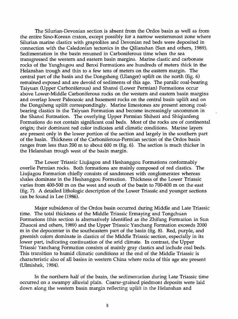
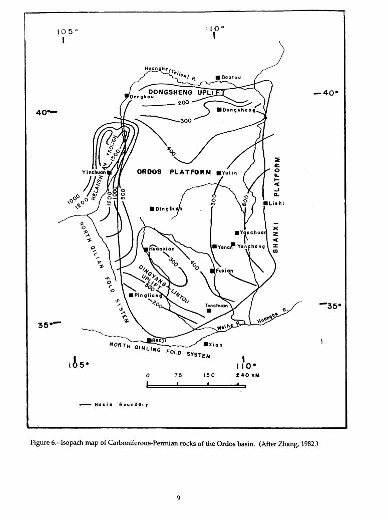
The Silurian-Devonian section is absent from the Ordos basin as well as from the entire Sino-Korean craton, except possibly for a narrow westernmost zone where Silurian marine elastics with graptolites and Devonian red beds were deposited in connection with the Caledonian tectonics in the Qilianshan (Sun and others, 1989). Sedimentation in the basin resumed in Carboniferous time when the sea transgressed the western and eastern basin margins. Marine clastic and carbonate rocks of the Yanghugou and Benxi Formations are hundreds of meters thick in the Helanshan trough and thin to a few tens of meters on the eastern margin. The central part of the basin and the Dongsheng (Ulanger) uplift on the north (fig. 6) remained exposed and are devoid of sediments of this age. The paralic coal-bearing Taiyuan (Upper Carboniferous) and Shanxi (Lower Permian) Formations occur above Lower-Middle Carboniferous rocks on the western and eastern basin margins and overlap lower Paleozoic and basement rocks on the central basin uplift and on the Dongsheng uplift correspondingly. Marine limestones are present among coal- bearing elastics in the Taiyuan Formation and become increasingly uncommon in the Shanxi Formation. The overlying Upper Permian Shihezi and Shiqianfeng Formations do not contain significant coal beds. Most of the rocks are of continental origin; their dominant red color indicates arid climatic conditions. Marine layers are present only in the lower portion of the section and largely in the southern part of the basin. Thickness of the Carboniferous-Permian section of the Ordos basin ranges from less than 200 m to about 600 m (fig. 6). The section is much thicker in the Helanshan trough west of the basin margin.
The Lower Triassic Liujiagou and Heshanggou Formations conformably overlie Permian rocks. Both formations are mainly composed of red elastics. The Liujiagou Formation chiefly consists of sandstones with conglomerates whereas shales dominate in the Heshanggou Formation. Thickness of the Lower Triassic varies from 400-500 m on the west and south of the basin to 700-800 m on the east (fig. 7). A detailed lithologic description of the Lower Triassic and younger sections can be found in Lee (1986).
Major subsidence of the Ordos basin occurred during Middle and Late Triassic time. The total thickness of the Middle Triassic Ermaying and Tongchuan Formations (this section is alternatively identified as the Zhifang Formation in Sun Zhaocai and others, 1989) and the Upper Triassic Yanchang Formation exceeds 2000 m in the depocenter in the southeastern part of the basin (fig. 8). Red, purple, and greenish colors dominate in elastics of the Middle Triassic section, especially in its lower part, indicating continuation of the arid climate. In contrast, the Upper Triassic Yanchang Formation consists of mainly gray elastics and include coal beds. This transition to humid climatic conditions at the end of the Middle Triassic is characteristic also of all basins in western China where rocks of this age are present (Ulmishek, 1984).
In the northern half of the basin, the sedimentation during Late Triassic time occurred on a swampy alluvial plain. Coarse-grained piedmont deposits were laid down along the western basin margin reflecting uplift in the Helanshan and
105 I
1 1C
35'
DONG3HEN6 UPLIDengkou
4O'
75i
150 240 KM
Bati n Bou ndary
Figure 6.-Isopach map of Carboniferous-Permian rocks of the Ordos basin. (After Zhang, 1982.)

40*-
35
is-75 i
150
II IO C£40 KM
4O
'35'
Bo « i n Boundary
Figure 7.-Isopach map of Lower Triassic rocks of the Ordos basin. (After Zhang, 1982.)
10

105 I
40*-
35'
DONGSHENG UPLIFT OS. -^
0.4 Dongshcnq
0.6
4O
'35'
^ B D««p lok«, source rockfactes in Upper Tnossic Hujiocun Formation (lower Yonchong)
80 « i n Boundary
Figure 8.-Isopach map of Middle-Upper Triassic rocks of the Ordos basin. (Compiled from Zhang, 1982, and Han and Yang, 1980.)
11
Liupanshan. The depocenter in the Tongchuan depression (fig. 8) was occupied by a lake. Periodically the lake deepened, anoxic conditions developed over the bottom, and bituminous black muds were deposited. Organic-rich black shales appear in the Middle Triassic Tongchuan Formation, but they become abundant in the Upper Triassic. These black shales are the main source rocks for oil fields of the Ordos basin.
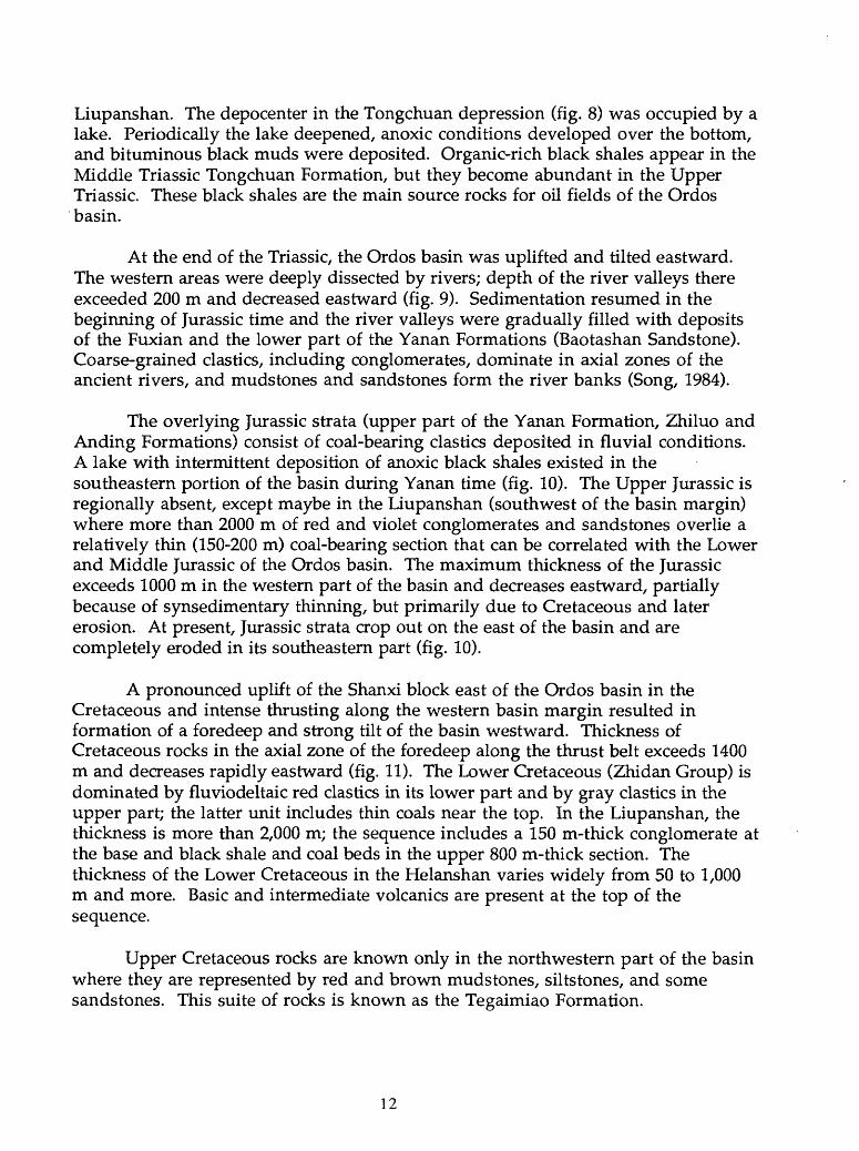
At the end of the Triassic, the Ordos basin was uplifted and tilted eastward. The western areas were deeply dissected by rivers; depth of the river valleys there exceeded 200 m and decreased eastward (fig. 9). Sedimentation resumed in the beginning of Jurassic time and the river valleys were gradually filled with deposits of the Fuxian and the lower part of the Yanan Formations (Baotashan Sandstone). Coarse-grained elastics, including conglomerates, dominate in axial zones of the ancient rivers, and mudstones and sandstones form the river banks (Song, 1984).
The overlying Jurassic strata (upper part of the Yanan Formation, Zhiluo and Anding Formations) consist of coal-bearing elastics deposited in fluvial conditions. A lake with intermittent deposition of anoxic black shales existed in the southeastern portion of the basin during Yanan time (fig. 10). The Upper Jurassic is regionally absent, except maybe in the Liupanshan (southwest of the basin margin) where more than 2000 m of red and violet conglomerates and sandstones overlie a relatively thin (150-200 m) coal-bearing section that can be correlated with the Lower and Middle Jurassic of the Ordos basin. The maximum thickness of the Jurassic exceeds 1000 m in the western part of the basin and decreases eastward, partially because of synsedimentary thinning, but primarily due to Cretaceous and later erosion. At present, Jurassic strata crop out on the east of the basin and are completely eroded in its southeastern part (fig. 10).
A pronounced uplift of the Shanxi block east of the Ordos basin in the Cretaceous and intense thrusting along the western basin margin resulted in formation of a foredeep and strong tilt of the basin westward. Thickness of Cretaceous rocks in the axial zone of the foredeep along the thrust belt exceeds 1400 m and decreases rapidly eastward (fig. 11). The Lower Cretaceous (Zhidan Group) is dominated by fluviodeltaic red elastics in its lower part and by gray elastics in the upper part; the latter unit includes thin coals near the top. In the Liupanshan, the thickness is more than 2,000 m; the sequence includes a 150 m-thick conglomerate at the base and black shale and coal beds in the upper 800 m-thick section. The thickness of the Lower Cretaceous in the Helanshan varies widely from 50 to 1,000 m and more. Basic and intermediate volcanics are present at the top of the sequence.
Upper Cretaceous rocks are known only in the northwestern part of the basin where they are represented by red and brown mudstones, siltstones, and some sandstones. This suite of rocks is known as the Tegaimiao Formation.
12

IO5
35'
is-
no
1I 10*
75 150 £40 KM
Basin Boundary
'35'
Figure 9.-Jurassic paleogeography of the Ordos basin. (After Sun and others, 1989.)
13

10 5
40'
35
40'
O*«p take. 9ource rock facie* in Iovr«r-middle Yanan Fm.
75 150 £4O KM
Bo « i n Boundary
Figure 10. Isopach map of Jurassic rocks of the Ordos basin (Compiled from Zhang, 1982, Sun and others, 1983, and Han and Yang, 1980.)
14

10 5'
i
35'
4O
'35'
05*
Xi Q n NORTH QINLING FOLD SYSTEM
75
i
150
II 10"£40 KM
Bo sin Boundary
Figure 11. Isopach map of Cretaceous rocks of the Ordos basin. (After Zhang, 1982.)
15

Cenozoic rocks of the Ordos basin are confined to grabens surrounding the basin on the north, west, and south (Hetao graben system, Yinchuan graben, and Weihe graben respectively see figure 13). The grabens are the westernmost part of the Shanxi rift system that stretches into eastern China. The rifting originated in middle Paleogene time and continued through the Quaternary. At present, the grabens control the position of the Yellow River (Huanghe) Valley and its tributaries. The lower part of the Cenozoic sedimentary section in the grabens is mainly composed of coarse continental clastic rocks; more fine-grained fluvial and lacustrine facies dominate in the upper part. Thickness of the section in the Yinchuan graben is almost 3 km, in other grabens it is probably less (Wang, 1969). An alternate assessment suggests significantly larger thicknesses of Tertiary rocks: 9,000 m in the Hetao graben and 6,000 m in the other two grabens (Zhang, 1982).
TECTONICS
In the view of Chinese geologists, the Ordos basin (as well as the Sichuan basin) occupies the intermediate position between the compression-dominated basins of western China and the extensional rifted basins of eastern China (Li, 1983a, 1990; Chen and Dickinson, 1986). The basin occupies the western part of a crustal block that was characterized by a stable tectonic regime during the Paleozoic and Mesozoic and was rifted in the Tertiary. The Qilian fold system southwest of the basin was formed during Caledonian orogeny at about the end of Silurian time. The Inner Mongolian fold system north of the basin and the Qilian fold system south of it were formed during late Hercynian-early Kimmerian tectonic events in the course of agglomeration of the Asian continent (Watson and other, 1987; Ji and Coney, 1985). During much of Paleozoic time, the stable block was separated from more western structures of the Sino-Korean craton (Alashan, Beishan) by the Helan aulacogen (fig. 6) which was structurally inverted and deformed probably during Triassic time in response to transpression along the north-south zone of dextral shearing (Watson and others, 1987; Sun and Liu, 1983).
The lower Paleozoic section of the basin unconformably overlies the Archean-Early Proterozoic crystalline basement rocks and Middle-Late Proterozoic quartzites and siliceous limestones occurring in grabens (Sun Zhaocai and others, 1989). Stable platform conditions characterized most of the basin; but along its southern and western margins, turbidites and other sediments characteristic of continental slopes on passive tectonic margins were deposited (figs. 3-5). A relative uplift occupied central and northern areas of the basin; the thickness increased toward the present Shanxi high.
During Silurian and Devonian time, the Ordos basin was uplifted along with the entire Sino-Korean craton. Only in a narrow zone of the western basin margin were Silurian marine deposits laid down. They were overlain by Devonian continental red bed molasse derived from the Caledonian orogen of Qilian.
16

A new stage of basin subsidence began in Middle Carboniferous time. The Hercynian structure is characterized by uplifts in the northern and southern parts of the basin and by depressions on the western and eastern margins (fig. 6). The latter depression clearly extended into the present-day Shanxi high. Beginning in Late Permian time, the sea regressed southward and continental sedimentation, characteristic of the rest of geologic history of the Ordos basin, was established.
The Early Triassic structure (fig. 7) resembles that of the Carboniferous- Permian, but the western basin margin was uplifted in connection with partial structural inversion of the Helanshan aulacogen. A significant tectonic reorganization occurred during Middle-Late Triassic time with formation of the deep Tongchuan depression that embraced a large southeastern portion of the basin (fig. 8). The depression continued eastward of the Ordos basin, along the foredeep of the Qinling fold system (Sun Zhaocai and others, 1989). At the end of Triassic time, the basin, together with the Shanxi platform, were uplifted and tilted northeastward. River valleys were deeply cut into Triassic sediments; the depth of erosion decreased eastward (fig. 9).
Thrusting along the western basin margin, formation of the western foredeep due to thrust loading, tilting of the basin westward, and uplift of the Shanxi block began in Late Jurassic time and continued into the Cretaceous (figs. 10-12). The eastern margin of the present-day Ordos basin was formed during this time as a result of erosional removal of thick older rocks from the Shanxi high. Tertiary rifting along the basin margins completed the tectonic development of the Ordos basin.
The present-day structure of most of the basin is a simple, almost unstructured homocline that dips westward toward the Liupanshan and Helanshan (fig. 13). The western basin margin is deformed by a series of imbricate thrust faults that have transported rocks eastward over a distance of 20-40 km (fig. 14). The thrust faults flatten with depth and are believed to merge in a nearly horizontal decollement zone in the Carboniferous coal measure (Guo and Zhang, 1989).
PETROLEUM GEOLOGY AND POTENTIAL EXPLORATION PLAYS
Oil has been produced for centuries from hand-dug wells in the Yanchang area (fig. 13). Drilling began in 1907 and the first well produced 60 b/d of oil from a depth of 76 m (Meyerhoff, 1982). However, significant exploration efforts did not begin until 1951. Since that time, a number of oil and gas fields have been found; most discoveries were made during the 1970s-1980s.
Most of the discovered oil fields are found in traps connected with an erosional unconformity and an incised paleodrainage system at the boundary between the Triassic and the Jurassic (fig. 15). These paleogeomorphic traps are variable; oil pools are found at the top of the Triassic in buried hills (fig. 16), in
17

W END OF ZHIDAN-3 AGE
KiZ4 YANWU CHENHAO-E. HUACHI-FUZIEN-GANQUAN
1200-
240X).END OF JURASSIC
BASE OF CRETACEOUS
600-
1200END OF YANAN
BASE OF ZHILUO FORMATION
500-
1000-
400-
eoa
0
400
END OF YANAN-9 AGE BASE OF YAN-8 STRATUM
BASE OF T3Y4END OF YANCHANG-3 AGE
meters0, 10 20 /° km.
Figure 12. Paleostructural cross sections showing formation of the foredeep in the western Qrdos basin in Cretaceous time. (After Song, 1984.)
18

05 I I 0
35*'
4O
is-
'35'
Basin boundary
Contour lines, meters
Erosional boundary of JurassicFaults
Oil and gas fields
Batin Boundary
Figure 13.-Structure of the Ordos basin on base of the Yanan-6 Member of the Jurassic Yanan Formation. (After Song, 1984.)
Oil and gas fields: \, Yongping; 2, Yanchang; 3, Yanan; 4, Maling; 5, Qizi; 6, Chenghao; 7, Zhiluo; 8, Nanliang; 9, Mafang; 10, Tianchi; 11, Qican
19

w0
2500-
50
00
-
7500-
(m)
K3 o
Figu
re 1
4.-C
ross
sec
tion
thro
ugh
the
wes
tern
thr
ust b
elt o
f th
e O
rdos
bas
in.
(Aft
er T
ang
and
othe
rs, 1
988.
) T
he p
ositi
on
of t
he c
ross
sec
tion
is n
ot i
ndic
ated
. T<
j - T
|2 a
re s
trat
igra
phic
uni
ts o
f th
e T
rias
sic
sect
ion.

o
0 8 16 24 32 km till j
,20' Isopach. m
OH Field
YANAN
FUXIAN
Figure 15.-Isopach map of members 9 and 10 of the Jurassic Yanan Formation. (After Song, 1984.) These two basal members of the Jurassic fill erosional relief, which was developed by incision of a river system at the Triassic/Jurassic unconformity. Numerous oil fields are controlled by paleomorphic traps.
21

50
0n
45
0
40
0
Juro
stie
Tri
ott
ie
Unc
onfo
rmity
Figu
re 1
6.-C
ross
sec
tion
thro
ugh
the
Zhi
luo
oil-
gas
fiel
d, O
rdos
bas
in.
(Aft
er S
ong,
198
4.)
The
se
stra
tigra
phic
poo
ls a
re i
n an
ero
sion
al h
ill i
n T
rias
sic
rock
s be
neat
h th
e T
rias
sic/
Jura
ssic
un
conf
orm
ity.

pinch-outs and drape structures over buried hills in basal Jurassic sandstones (fig. 17), and in sandstone lenses of various origin (bars, distributary channels, deltaic sand lenses). Reportedly, some hydrocarbon pools (mainly gas) have been recently found in Permian through Jurassic rocks in anticlinal traps of the western thrust belt (i.e. Majiatan field - Lee, 1986) and in upper Paleozoic rocks in stratigraphic traps on the north of the basin (Sun Zhaocai and others, 1989). No detailed data on these pools are available from the literature, and their precise position cannot be indicated.
Two gas pools (Tianchi and Qican, fig. 13) were recently found in Ordovician rocks of the basin. The pools are in simple structural traps (fig. 18). Gas was tested from the Permian Shihezi Formation and from the Lower Ordovician Majiagou Formation on the Tianchi structure at 2608-2618 and 3676-3959 m correspondingly. Both formations were tested simultaneously and produced 328,000 m3/day (12 MM cfd). Different isotopic compositions of gas from the two formations is interpreted to reflect different sources for gas: Carboniferous-Permian coals for the upper pay and lower Paleozoic carbonate rocks for the lower pay (Dai and Xia, 1990). Two more gas shows were obtained from wells east of the Qican structure.
Organic-rich shales deposited in lakes under anoxic conditions are potential petroleum source rocks of excellent quality. These shales are thickest in the Upper Triassic Yanchang Formation. They are also present in the Middle Triassic Tongchuan Formation and in the Middle Jurassic Yanan Formation. The distribution of these lacustrine deposits is shown in figures 8 and 10. However, oil/source rock correlation studies indicate that oil accumulations in both Upper Triassic and Jurassic rocks were derived from Triassic source rocks whereas Jurassic shales are immature (Huang and others, 1988; Song, 1984; Lee, 1986). Average TOC in Triassic black shales is 2.4%, and they contain 1060 ppm of hydrocarbons (Sun Zhaocai and others, 1989).
In the Paleozoic section of the basin, potentially rich gas source rocks are present in the widespread Carboniferous and Lower Permian coal-bearing formations, especially in the Taiyuan Formation. The coal-bearing formations cover more than 250,000 km2 of the basin area. Some oil shows are believed to be related to these source rocks (Wang and Liu, 1983). Carboniferous source rocks have been studied in the northern part of the Ordos basin (Sun and others, 1983; Zhu Zongqi and others, 1981). The rocks are in the oil window in a narrow zone along the northern and western basin margins; the maturity increases rapidly toward the basin center (fig. 19).
Ordovician and possibly older lower Paleozoic carbonate rocks are believed to be a source for gas in the Lower Ordovician Majiagou Formation (Dai and Xia, 1990). Geochemical data on these rocks are very limited. The average TOC content in 63 carbonate samples ranging in depth from 1139 to 3959 m from 12 wells in the Ordos basin is only 0.21%. However, this average concentration probably does not characterize the organic richness of all strata; for example, TOC values as high as
23
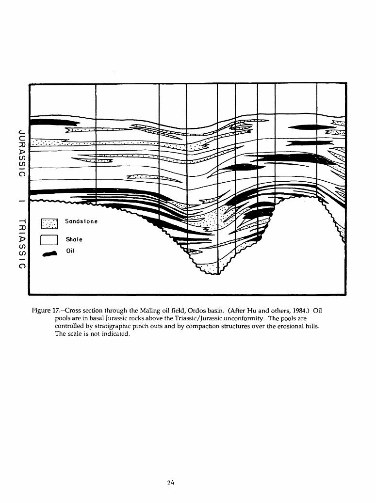
Figure 17. Cross section through the Maling oil field, Ordos basin. (After Hu and others, 1984.) Oil pools are in basal Jurassic rocks above the Triassic/Jurassic unconformity. The pools are controlled by stratigraphic pinch cuts and by compaction structures over the erosional hills. The scale is not indicated.
24

wsw ENE1500-
2000
2500
Tih-H
Figure 18.-Cross section through the Tianchi gas field, Ordos basin. (After Dai and Xia, 1990.) A gas pool in Permian rocks is not shown. C2b-Carboniferous Benxi Formation; PIS, Lower Permian
Shanxi Formation; Pj^sh, Lower-Upper Permian Shihezi Formation; P2S, Upper PermianShiqianfeng Formation; T, h +1, Lower Triassic Heshanggou and Liujiagou Formations. The scale is not indicated.
25
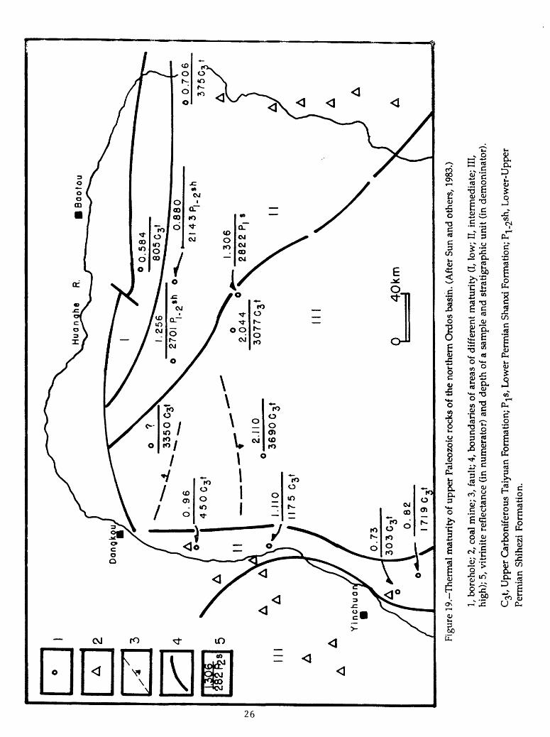
Figu
re 1
9. T
herm
al m
atur
ity o
f upp
er P
aleo
zoic
roc
ks o
f th
e no
rthe
rn O
rdos
bas
in. (
Aft
er S
un a
nd o
ther
s, 1
983.
)
1, b
oreh
ole;
2, c
oal
min
e; 3
, fau
lt; 4
, bou
ndar
ies
of a
reas
of
diff
eren
t m
atur
ity
(I, l
ow;
II, i
nter
med
iate
; II
I, hi
gh);
5, v
itrin
ite r
efle
ctan
ce (
in n
umer
ator
) an
d de
pth
of a
sam
ple
and
stra
tigra
phic
uni
t (in
dem
onin
ator
).
C^t
, Upp
er C
arbo
nife
rous
Tai
yuan
For
mat
ion;
PjS
, Low
er P
erm
ian
Shan
xi F
orm
atio
n; P
^sh
, L
ower
-Upp
er
Perm
ian
Shih
ezi
Form
atio
n.
0.64% have been recorded. Although oil-prone kerogen type II dominate in the rocks, the organic matter is strongly overmature. In a Qican field well, the R0 value at 2835 m is 2.31. Possibly, rocks with better source potential can be expected in the Middle Ordovician section deposited in the upper part of the continental slope on the basin margins and in the Helanshan aulacogen where graptolitic shales are present. However, the source rock potential of lower Paleozoic rocks of the basin is poorly known and more studies are necessary for a reliable evaluation.
The average thermal gradient in the Ordos basin is 2.75°C/100 m (1.5° F/100 ft) (Zhai and others, 1988). However, significant removal of strata, especially in the eastern areas of the basin, preclude the assessment of thermal maturity based on the geothermal gradient. Available assessments suggest that Triassic source rocks are in the oil window over most of the basin whereas Jurassic rocks are immature everywhere except probably in the western foredeep where Jurassic strata do not contain anoxic lacustrine source rocks.
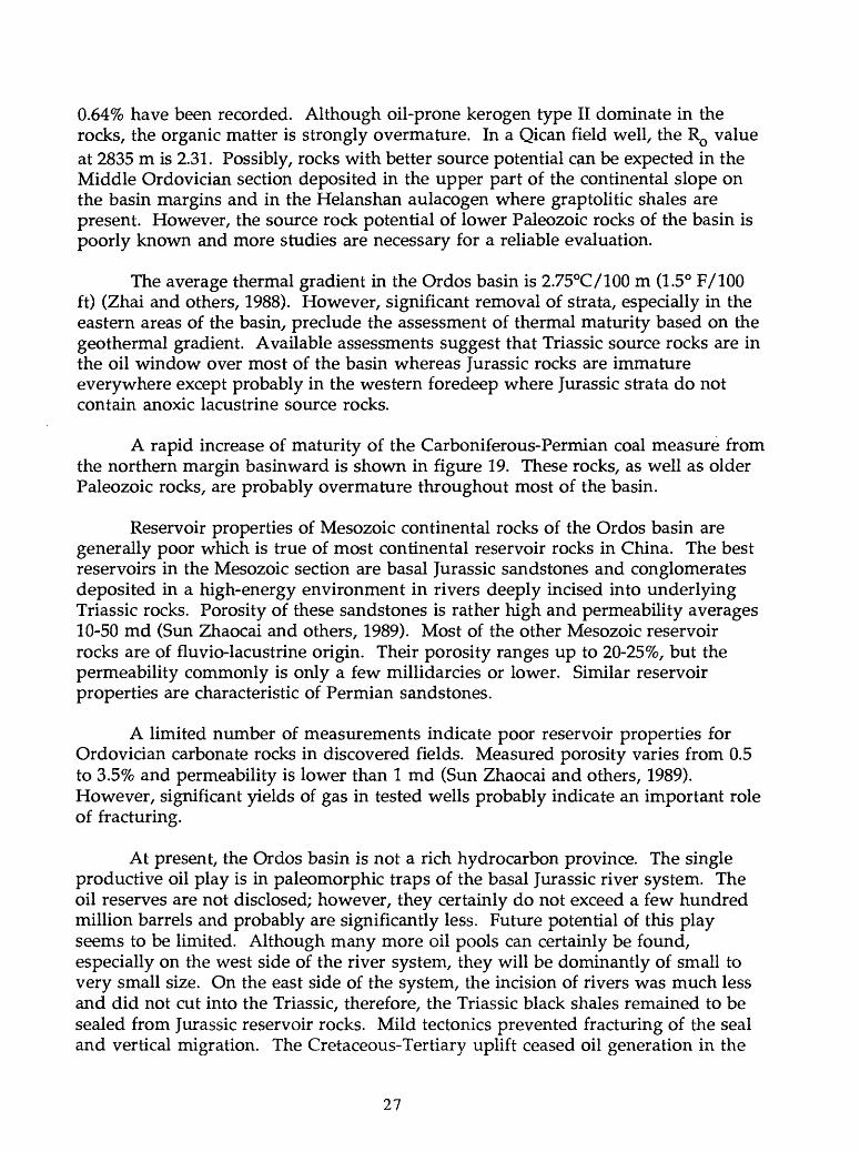
A rapid increase of maturity of the Carboniferous-Permian coal measure from the northern margin basin ward is shown in figure 19. These rocks, as well as older Paleozoic rocks, are probably overmature throughout most of the basin.
Reservoir properties of Mesozoic continental rocks of the Ordos basin are generally poor which is true of most continental reservoir rocks in China. The best reservoirs in the Mesozoic section are basal Jurassic sandstones and conglomerates deposited in a high-energy environment in rivers deeply incised into underlying Triassic rocks. Porosity of these sandstones is rather high and permeability averages 10-50 md (Sun Zhaocai and others, 1989). Most of the other Mesozoic reservoir rocks are of fluvio-lacustrine origin. Their porosity ranges up to 20-25%, but the permeability commonly is only a few millidarcies or lower. Similar reservoir properties are characteristic of Permian sandstones.
A limited number of measurements indicate poor reservoir properties for Ordovician carbonate rocks in discovered fields. Measured porosity varies from 0.5 to 3.5% and permeability is lower than 1 md (Sun Zhaocai and others, 1989). However, significant yields of gas in tested wells probably indicate an important role of fracturing.
At present, the Ordos basin is not a rich hydrocarbon province. The single productive oil play is in paleomorphic traps of the basal Jurassic river system. The oil reserves are not disclosed; however, they certainly do not exceed a few hundred million barrels and probably are significantly less. Future potential of this play seems to be limited. Although many more oil pools can certainly be found, especially on the west side of the river system, they will be dominantly of small to very small size. On the east side of the system, the incision of rivers was much less and did not cut into the Triassic, therefore, the Triassic black shales remained to be sealed from Jurassic reservoir rocks. Mild tectonics prevented fracturing of the seal and vertical migration. The Cretaceous-Tertiary uplift ceased oil generation in the
27
Triassic source rocks, and the generative potential of the Jurassic black shales has not been realized.
The western thrust belt is considered a highly potential play by Chinese geologists (Tang and others, 1988; Guo and Zhang, 1989). However, the reasons for the high expectations for this play are not obvious. Triassic and Jurassic black lacustrine shales do not extend into the thrust belt except for a small area in its central part (fig. 8). Alluvial facies of these strata can be expected to contain mainly terrestrial organic matter with gas-prone type HI kerogen. Gas source rocks are also characteristic of the Paleozoic section of the belt due to both organic matter type and overmaturation. Sealing conditions are an obvious problem in the highly faulted thrust sheets (fig. 14). Better sealing can probably be expected in the subthrust structures, but the tectonics is complex, the seismic resolution is poor, and the exploration is highly risky. In general, this play does not seem to be very promising and is clearly gas-prone.
A potentially rich gas play is associated with the Carboniferous-Lower Permian coal measure that is present over most of the Ordos basin. The best reservoirs are in the Upper Permian Shihezi Formation (Sun Zhaocai and others, 1989); interlayered and overlying shales provide the seals. Structural traps (drapes over basement highs) similar to that in the Qican field (Dai and Xia, 1990) are most promising, but their abundance remains to be demonstrated. Pinch-out zones of Middle Carboniferous marine elastics against the Dongsheng uplift and the paleohigh in the central part of the basin (fig. 6) may contain significant stratigraphic traps. This play has a greater potential in the north part of the basin where source rocks are at lower stages of thermal maturity.
Gas discoveries in Ordovician carbonates highlight the lower Paleozoic prospects of the basin. The problem with the play is the uncertainty in quality and distribution of source rocks. The interpretation that assigns organically lean Ordovician carbonates as the source rock for gas discoveries in this section (Dai and Xia, 1990) is suspect. The gas could have been sourced from upper Paleozoic coal- bearing rocks and migrated across the pre-Carboniferous unconformity into underlying carbonates. More data are needed to understand the importance of this unconformity in prospecting for gas in the basin. Structural drapes over basement highs, analogous to those in discovered fields, possess the highest potential.
The southern margin of the basin has a good potential for hydrocarbons in the Ordovician section, especially in the Middle Ordovician reef play. The paleogeographic situation (fig. 5) indicates the presence of basinal facies (Pingliang Formation) in the Qinling fold belt and on the craton edge, a narrow zone of open- shelf limestones, and lagoonal facies farther basinward. This situation suggests a high probability for the presence of reefs on the basin margin. Source rocks for this play may be present in lagoonal and basinal facies. The latter are now strongly deformed in the Qinling geosyncline, but they are also present in an unmeta- morphosed zone along the southern and southwestern slopes of the craton (fig. 3).
28
SICHUAN BASIN
INTRODUCTION
The Sichuan (Red) basin is located in the western part of the Yangtze craton in southern China (fig.l). The basin has a rhombic shape which was acquired after a series of compressional deformations that took place during Mesozoic and Tertiary time. Along all its perimeter, the basin is surrounded by mountain chains (fig. 20). The basin area is 230,000 km2 (88,000 mi2).
Wells with bamboo pipes were drilled in the basin for salt brine production thousands of years ago. Later, some wells were drilled for gas which was used for heating the brine and precipitating salt (Meyerhoff, 1982). One well reached the depth of more than 1000 m as early as in the early 19th century (Wang and others, 1989). Modern drilling began in 1937 on the Weiyuan structure, and during 1944- 1954, a number of other anticlines were involved in exploration with the technical assistance of Soviet geologists. At present, the basin is the major producer of gas in China, but the discovered amount of oil is small.
STRATIGRAPHY
The basement of the Sichuan basin in its central, northeast-trending zone consists of an Early Proterozoic metamorphic terrane. On the northwest and southeast, the upper Sinian through Tertiary sedimentary cover is underlain by diagenetically strongly altered lower Sinian elastics which may be considered an economic basement (Yin, 1985).
The upper Sinian (latest Proterozoic) section covers the basement rocks. Basal elastics, apparently of glacial origin, are present mainly on the east-southeast side of the basin. Overlying rocks are marine shales, chert, and algal (often vuggy) dolomite (Denying Formation). The dolomite is productive in several gas fields. The maximum thickness of the formation exceeds 1,000 m. Climatic conditions during deposition of the shales and carbonates were arid as indicated by inclusions of salt and gypsum in contemporaneous rocks of neighboring regions (Liu and others, 1973).
The lower Paleozoic overlies Sinian rocks with significant unconformity (table 1). The Cambrian, Ordovician, and Silurian are composed mainly of carbonate rocks with some shales, such as a graptolitic shale at the base of the Silurian (Johnson and others, 1985). Thickness of this section in the basin varies from 500 to 2,500 m. A flysch trough filled with as much as 10,000 m of lower Paleozoic rocks was located in the Longmenshan. Another trough with a 5-km thick lower Paleozoic section is found southeast of the basin (fig. 21).
Devonian and Carboniferous rocks are absent from most of the Sichuan basin. Only on the east side of the basin, thin (50-200 m) Upper Carboniferous sandy and vuggy dolomites and limestones are present and contain several gas fields
29
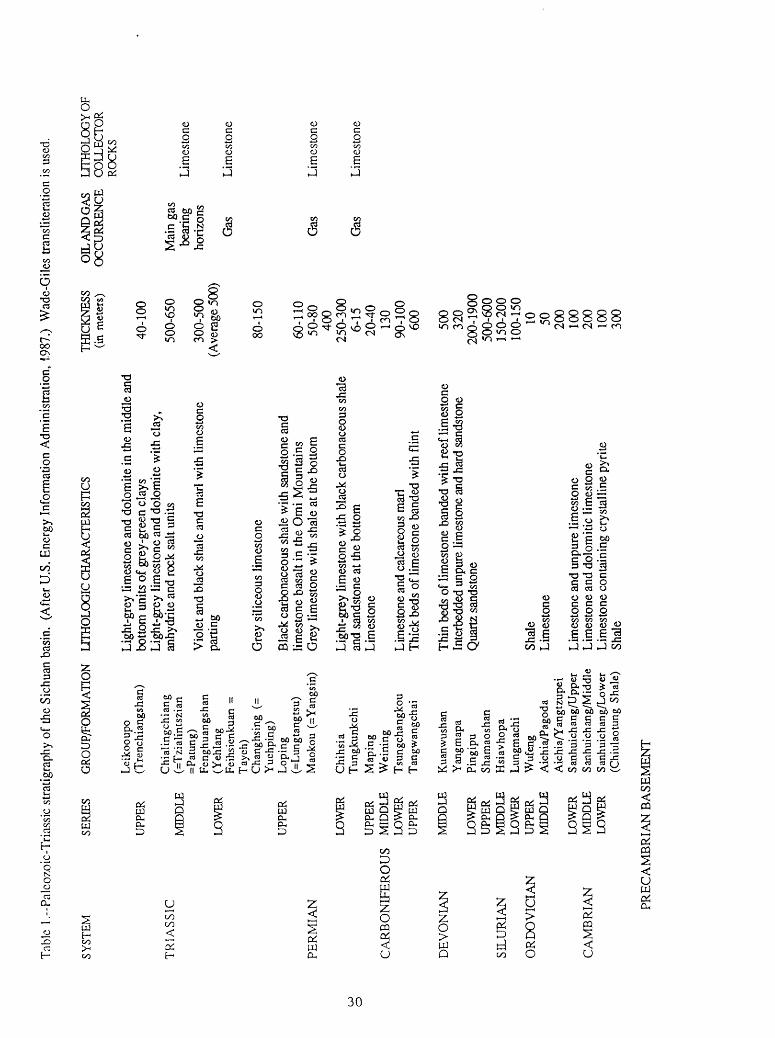
Tabl
e l.-
Palc
ozoi
c-T
rias
sic
stra
tigra
phy
of th
e Si
chua
n ba
sin.
(A
fter U
.S. E
nerg
y In
form
atio
n A
dmin
istra
tion,
198
7.)
Wad
e-G
iles
trans
liter
atio
n is
used
.
SYST
EMSE
RIES
G
RO
UP/
FOR
MA
TIO
N
LTTH
OLO
GIC
CH
AR
AC
TER
ISTI
CS
TR
IAS
SIC
PER
MIA
N
UPP
ER
MID
DLE
LOW
ER
UPP
ER
LOW
ERo
UPP
ERC
AR
BO
NIF
ER
OU
S M
IDD
LE
LOW
ER
UPP
ER
Lei
koou
po
(Tre
nchi
angs
han)
Chi
alin
gchi
ang
(=T
zial
ints
zian
=Pat
ung)
Feng
huan
gsha
n(Y
ehla
ngFe
ihsi
enku
an =
Tay
eh)
Cha
nghs
ing
(=Y
uehp
ing)
Lop
ing
(=L
ungt
angt
su)
Mao
kou
(=Y
angs
in)
Chi
hsia
Tun
gkun
kchi
Map
ing
Wei
ning
Tsu
ngch
angk
ouT
angw
angc
hai
Ligh
t-gre
y lim
esto
ne a
nd d
olom
ite in
the
mid
dle
and
botto
m u
nits
of g
rey-
gree
n cl
ays
Ligh
t-gre
y lim
esto
ne a
nd d
olom
ite w
ith c
lay,
an
hydr
ite a
nd ro
ck s
alt u
nits
Vio
let a
nd b
lack
sha
le a
nd m
arl w
ith li
mes
tone
pa
rting
Gre
y si
liceo
us li
mes
tone
Bla
ck c
arbo
nace
ous
shal
e w
ith s
ands
tone
and
lim
esto
ne b
asal
t in
the
Om
i M
ount
ains
G
rey
limes
tone
with
sha
le a
t the
bot
tom
Ligh
t-gre
y lim
esto
ne w
ith b
lack
car
bona
ceou
s sh
ale
and
sand
ston
e at
the
botto
mLi
mes
tone
Lim
esto
ne a
nd c
alca
reou
s m
arl
Thic
k be
ds o
f lim
esto
ne b
ande
d w
ith f
lint
DEV
ON
IAN
SILU
RIA
N
OR
DO
VIC
IAN
CA
MB
RIA
N
MID
DLE
LOW
ERU
PPER
MID
DLE
LOW
ERU
PPER
MID
DLE
LOW
ERM
IDD
LELO
WER
Kua
nwus
han
Yan
gmap
aPi
ngip
uSh
amao
shan
Hsi
avho
paLu
ngm
achi
Wuf
eng
Aic
hia/
Pago
daA
ichi
a/Y
angt
zupe
iS a
nhui
ch an
g /U
pper
Sanh
uich
ang/
Mid
dle
Sanh
uich
ang/
Low
er(C
hiul
aotu
ng S
hale
)
Thin
bed
s of
lim
esto
ne b
ande
d w
ith r
eef l
imes
tone
Inte
rbed
ded
unpu
re li
mes
tone
and
har
d sa
ndst
one
Qua
rtz s
ands
tone
Shal
eLi
mes
tone
Lim
esto
ne a
nd u
npur
e lim
esto
neLi
mes
tone
and
dol
omiti
c lim
esto
neLi
mes
tone
con
tain
ing
crys
talli
ne p
yrite
Shal
e
THIC
KN
ESS
(in m
eter
s)
40-1
00
500-
650
300-
500
(Ave
rage
500
)
80-1
50
60-1
10
50-8
040
0 25
0-30
06-
15
20-4
013
0 90
-100
600
500
320
200-
1900
500-
600
150-
200
100-
150
10 50 200
100
200
100
300
OIL
AN
D G
AS
LITH
OLO
GY
OF
OC
CU
RR
ENC
E C
OLL
ECTO
R
ROCK
S
Mai
n ga
s be
arin
g ho
rizon
s
Gas
Lim
esto
ne
Lim
esto
ne
Gas
Li
mes
tone
Gas
Li
mes
tone
PREC
AM
BR
IAN
BA
SEM
ENT

I05e
Tong jiong \ Depression
105
Figure 20.-Main structural units of Sichuan basin. (After Wang and others, 1983.)
31

105
IO5
Figure 21. Isopach map (in meters) of lower Paleozoic rocks of the Sichuan basin. (After Wang and others, 1983.)
32
(Chen, 1982). These carbonate rocks occur between two unconformities that enhanced their reservoir properties. They were deposited in a long and narrow bay that penetrated into the basin from the epicontinental sea of southern and eastern regions of South China (Li and Li, 1988).
In pre-Permian time, the Sichuan basin area was strongly uplifted and deeply eroded. Permian rocks unconformably overlie older rocks ranging in age from the Sinian to the Carboniferous (fig. 22). Carbonate rocks dominate in the Lower Permian section. Algal reef facies are widespread, and they are mainly concentrated around the ancient uplifts. Black and gray clayey limestones of the Yangxin Formation were probably deposited in more deep-water environments. These limestones are believed to be the major source rock for gas in the basin (Huang, 1984). Upper Permian rocks were deposited in paralic conditions, and the section is composed of carbonate and clastic beds with layers of coal. On the west and east, the section includes widespread basalt flows at the base (Emei Basalt).
Unlike in the North China domain, marine sedimentation in the Sichuan basin continued into Early and Middle Triassic time. Carbonate sediments were deposited in the eastern part of the basin during the Early Triassic. Westward, carbonate rocks pass into variegated shales and sandstones of the Feixianguan Formation (Sun Shu and others, 1989). The Middle Triassic is mainly composed of carbonate rocks on the periphery of the basin. Shallow-water algal banks and oolitic shoals are common. Dolomite, shale, gypsum, and salt dominate the Middle Triassic section in the central areas of the basin.
A marked change of depositional environments began in Late Triassic time. Marine sedimentation continued until Norian time in the northwestern part of the basin. Pre-Norian Upper Triassic rocks, that consist of reefal and oolitic carbonates and very thick deltaic and lacustrine elastics containing coals, unconformably onlap onto the uplifted southeastern basin area. At the end of the Norian, the Longmenshan was folded and uplifted and began to pour abundant coarse clastic material into the forming foredeep. In the foredeep, thickness of the Upper Triassic exceeds 3 km, and the section rapidly thins southeastward (fig. 23). Formation of the Longmenshan belt cut the connection of the Sichuan basin with the Tibetan sea and brought an end to marine sedimentation. This event started the formation of the Sichuan basin in its present-day boundaries.
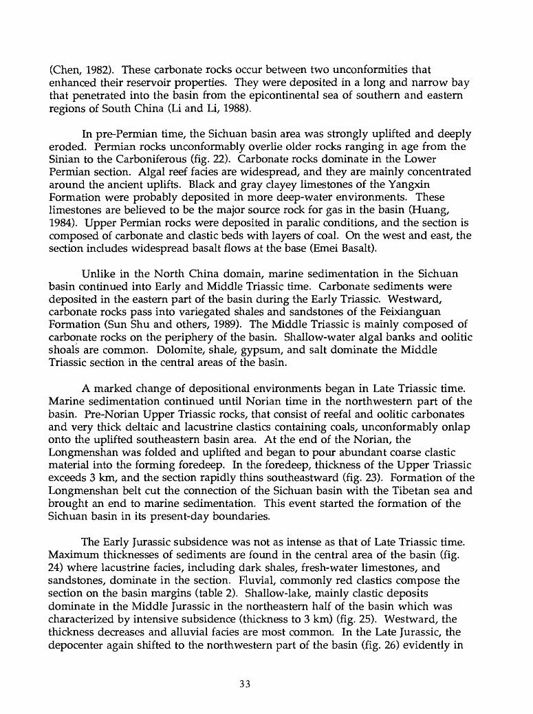
The Early Jurassic subsidence was not as intense as that of Late Triassic time. Maximum thicknesses of sediments are found in the central area of the basin (fig. 24) where lacustrine facies, including dark shales, fresh-water limestones, and sandstones, dominate in the section. Fluvial, commonly red elastics compose the section on the basin margins (table 2). Shallow-lake, mainly clastic deposits dominate in the Middle Jurassic in the northeastern half of the basin which was characterized by intensive subsidence (thickness to 3 km) (fig. 25). Westward, the thickness decreases and alluvial facies are most common. In the Late Jurassic, the depocenter again shifted to the northwestern part of the basin (fig. 26) evidently in
33

Tab
le 2
.-S
trat
igra
phy
of M
esoz
oic-
Ter
tiary
roc
ks o
f the
Sic
huan
bas
in.
(Aft
er Y
in,
1985
.)
SYST
EM
FORM
ATI
ON
Q
uate
rnar
y Pl
eist
ocen
e
Pale
ogen
e Eo
cene
Upp
er
Cre
tace
ous
Low
er
Upp
er
Mid
dle
Jura
ssic
Low
er
MEM
BER
THIC
KN
ESS
(m)
Tria
ssic
Upp
er
Mid
dle
Lus
han
Min
gsha
n
Gua
nkou
Jiag
uan
Gud
ian
Qiq
usi
Bai
long
C
angx
iPe
ngla
izhe
n
Suin
ing
Upp
er S
haxi
Low
er
Shax
imia
o Q
ianf
oya
Daa
nzha
i
Zili
ujin
g M
aans
han
(Bai
tianb
a)
Don
gyue
mia
o Z
honz
huch
ong
Upp
er
Xuj
iahe
M
iddl
e
Low
er
Xia
otan
gzi
Maa
ntan
g
>650
50
0-1,
200
400-
1,10
0
150-
800
>40-
150
200-
500
100-
400
200-
500
700-
1,50
0
300-
800
350-
2,90
010
0-70
0
100-
350
80-1
20
50-7
0 30
-60
100-
350
100-
500
0-1,
360
200-
650
0-90
0
0-45
0
Lei
koup
o
MA
TNLr
THO
LOG
Y
Yaa
n G
rave
l Bed
D
ayi C
ongl
omer
ates
Red
flu
vio-
lacu
stri
ne m
udst
one
and
silts
tone
X
R
ed f
luvi
o-la
cust
rine
san
dsto
ne, s
iltst
one
and
mud
ston
e in
terc
alat
ed w
ith
mar
lite
and
coar
seni
ng w
estw
ard.
Lac
ustr
ine
mud
ston
e, s
iltst
one,
mar
lite,
gyp
sum
, gl
aube
rite
etc
. in
Che
ngdu
ar
ea, a
nd re
d fl
uvio
-lac
ustr
ine
mod
erat
e-fm
e-gr
aint
ed s
ands
tone
in o
ther
are
as.
Fluv
ial
sand
-con
glom
erat
e ro
cks
Inte
rbed
s of
red
silts
tone
and
mud
ston
e, in
terc
alat
ed w
ith s
ands
tone
s an
d co
nglo
mer
ates
.G
reyi
sh g
reen
and
pur
plis
h gr
ey m
oder
ate-
grai
ned
sand
ston
e, s
iltst
one
and
mud
stone
, fin
ing
upw
ard
and
coar
seni
ng d
ownw
ard.
Cyc
loth
ems
cons
istin
g of
sand
ston
e an
d re
d m
udst
one
with
une
qual
thic
knes
s. M
issi
ve s
ands
tone
inte
rcal
ated
with
red
mud
ston
es.
Inte
rbed
s of
red
fluvi
o-la
cust
rine
sand
ston
es a
nd m
udst
ones
, tur
ning
into
flu
vial
san
d-co
nglo
mer
ate
beds
in f
ront
of L
ongm
en M
ts. (
i.e.,
Lian
huak
ou
Form
atio
n).
Red
mud
ston
e in
terc
alat
ed w
ith s
iltst
one
and
fine
sand
ston
e.
Red
flood
mud
ston
e in
terc
alat
ed w
ith fl
uvia
l san
dsto
ne.
Inte
rbed
s of
red-
gree
n flu
vio-
lacu
strin
e sa
ndst
one
and
mud
sto
to th
e to
p,
turn
ing
into
dar
k m
udst
one
and
shal
e.Re
d flu
vial
san
d-an
d-m
ud-s
tone
s in
the
sout
h, a
nd la
cust
rine
mud
ston
e an
d sh
ale
inte
rcal
ated
with
silt
ston
e an
d fin
e sa
ndst
one
in th
e no
rth a
nd in
the
east
. In
the
sout
h, r
ed a
nd g
reyi
sh g
reen
mud
ston
e in
terc
alat
ed w
ith s
helly
Is; i
n th
e m
iddl
e, d
ark
mst
and
sh
inte
rcal
ated
with
she
lly Is
. In
the
sout
h, re
d m
s in
terc
alat
ed w
ith s
s; in
the
mid
dle,
dar
k m
s an
d sh
. D
ark
grey
mis
t and
sh
inte
rcal
ated
with
she
lly I
s. In
the
sout
h an
d m
iddl
e, re
d m
s in
terc
alat
ed w
ith q
uartz
ose
silst,
thin
ning
no
rthw
ards
.In
the
low
er p
art,
mas
sive
san
d-co
nglo
mer
ate
rock
s; u
pwar
d, g
radu
ally
tur
ning
in
to s
s an
d m
st w
ith c
oal
stri
nger
s.C
yclo
them
s of
dar
k m
s and
sh,
and
qua
rtzos
e ss
inte
rcal
ated
with
coa
l str
inge
rs.
Feid
spht
hic
quar
tzos
e ss
and
pol
ymic
tic q
uartz
ose
ss, l
ocal
ly in
terc
alat
ed w
ith
cong
.; in
the
mid
dle
part,
inte
rcal
ated
with
arg
illac
eous
roc
ks.
Pred
omin
antly
mar
ine
clas
tic ro
cks,
inte
rcal
ated
with
con
tinen
tal s
iltst
, fin
e ss
an
d co
al s
tring
ers.
In th
e up
per p
art,
dark
gre
y sh
int
erca
late
d w
ith s
iltst
and
bio
clas
tic Is
; in
the
low
er p
art,
oolit
ic Is
and
bio
clas
tic Is
. Li
mes
tone
and
dol
omite
.

105' iio-
105
||| Devonian
^-v. Simon
" ""_ Ordovicion
m Combrion
_ Faults
'" &>££" Carboniferous
</>. Intermediates oc«dic inlrustves
f j Silurian
^ Basin boundary
^^: Pr«-Sinion
Figure 22.-Subcrop geologic map of the pre-Premian unconformity. (After Wang and others, 1983.)
35

105' 110'
30° 30 4
60 120km
105' 110°
Figure 23.-Isopach map (in meters) of Upper Triassic rocks of the Sichuan basin. (After Yin, 1985.)
36

30
105*T~ no <
0 60 120 km
30°
HO'
Limit of predominantly lacustrine facies
Figure 24. Isopach map (in meters) of Lower Jurassic rocks of the Sichuan basin. (After Yin, 1985.)

30'
O 60 l2Okm
105
........ Western limit of predominantly lacustrine facies
Figure 25.-Isopach map (in meters) of Middle Jurassic rocks of the Sichuan basin. (After Yin, 1985.)
38
105' 110*
30'
120km
105 I 10'
Figure 26.-Isopach map (in meters) of Upper Jurassic rocks of the Sichuan basin. (After Yin, 1985.)
39

connection with continuing thrusting in the Longmenshan. The rocks are mainly red fluvio-lacustrine sandstones, shales, and conglomerates.
Fluvial and, to a lesser extent, lacustrine clastic rocks compose the Cretaceous section (fig. 27). In the Early Cretaceous, deposition occurred mainly in the northern and western areas of the basin. Uplift of these areas in pre-Late Cretaceous time shifted the depocenter to the south. Paleocene-Eocene rocks are thick and are composed of similar lithologies. Maximum thicknesses of Paleocene-Eocene rocks occur in approximately the same areas as during Late Cretaceous time. At the end of the Eocene, the basin was uplifted and sedimentation resumed only in the Pleistocene with deposition of coarse clastic material.
TECTONICS
The Sichuan basin did not exist until Late Triassic time. Deposition of the upper Sinian-lower Paleozoic and Permian-Middle Triassic sequences occurred on the Yangtze craton near its western passive margin. Tectonic movements had a platform character with block-type basement-involved uplifts and depressions. Even the regional uplift at the end of Silurian time (probably related to compression and folding in the Cathasian belt) resulted in rather mild deformation with formation of a large gentle uplift in the western part of the basin (fig. 22). Massive eruptions of middle Permian Emei plateau basalts indicate regional tension and associated fracturing of the basement.
The first compressive deformation occurred in middle Late Triassic time in connection with folding and thrusting in the Longmenshan. This Indosinian deformation marks the collision of South China with the Songpan-Ganzi terrane on the northwest (Ji and Coney, 1985). A foredeep filled with thick Upper Triassic sediments was formed in response to loading by thrust sheets. The second episode of thrusting and formation of a foredeep probably occurred in the Dabashan in Middle Jurassic time (Bally and others, 1986). In pre-Late Cretaceous time, folding and regional uplift took place in the eastern Sichuan basin. Himalayan movements in post-Eocene time resulted in three episodes of folding in western Sichuan and thrusting and folding in eastern Sichuan (Wang and others, 1989). In the latter region, Tertiary (late Neocathasian) folding with strikes at 20° NE overprinted the earlier and gentler Late Jurassic-Cretaceous folds which strike 60° NE (Zheng, 1980).
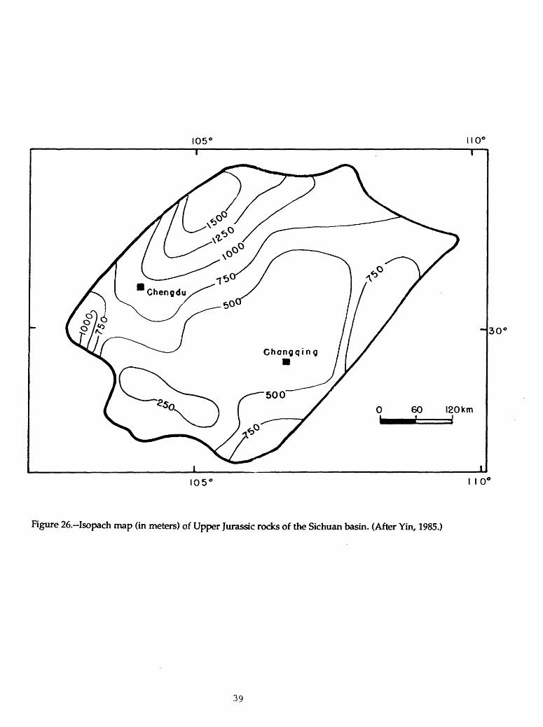
The present-day structure of the Sichuan basin is characterized by a generally uplifted central zone (Central and Weiyuan-Longnusi uplifts) and by a series of depressions along the basin margins adjoining the mountainous fold belts (fig. 20). The basement occurs at depths of 4-5 km on the uplifts and as deep as 7-10 km in the depressions. The northwestern and southeastern margins are most strongly deformed. The main mode of deformation is folding1 and thrusting with decollements at the basement level on the northwest and at the Silurian level on the southeast (figs. 28 and 29). A secondary decollement surface is probable in Triassic evaporites.
40

105 110
30*
0 60 120km
Limit of Cretaceous rocks
Figure 27.-Isopach map (in meters) of Cretaceous rocks of the Sichuan basin. (After Yin, 1985.)
41
NW
SE
OR
OG
EN
IC
FO
RE
DE
EP
B
EL
T
TH
RU
ST
BE
LT
CE
NT
RA
L
ST
AB
LE
A
RE
AM
OB
ILE
F
LA
NK
1 v'-i
BA
SE
ME
NT
SIN
IAN
-OR
OO
VIC
IAN
SIL
UR
IAN
DE
VO
NIA
N
&
CA
RB
ON
IFE
RO
US
PE
RM
IAN
- M
ID-T
RIA
SS
IC
UP
PE
R
TR
IAS
SIC
JUR
AS
SIC
CR
ET
AC
EO
US
ME
TA
MO
RP
HIC
Z
ON
E
Figu
re 2
8.
Eas
t-w
est
cros
s se
ctio
n th
roug
h th
e Si
chua
n ba
sin.
(A
fter
Wan
g an
d ot
hers
, 19
89.)
The
pre
cise
pos
ition
of
the
cros
s se
ctio
n is
not
indi
cate
d.

NW
2000-
40
00
-
6000
H
8000-
SE
Figu
re 2
9.~C
ross
sec
tion
thro
ugh
the
thru
st z
one
of th
e L
ongm
ensh
an, S
ichu
an b
asin
. (A
fter
Liu
, 198
6.)
The
pre
cise
po
sitio
n of
the
cros
s se
ctio
n is
not
indi
cate
d. S
ubsc
ript
s w
ith le
tter
T in
dica
te v
ario
us u
nits
of T
rias
sic
rock
.

PETROLEUM GEOLOGY AND POTENTIAL EXPLORATION PLAYS
The Sichuan basin is the largest gas producer in China. More than 60 gas fields have been found, most of them of small to medium size. The larger fields are shown in figure 30. The largest gas field is the Weiyuan field with reserves of about 1.3 TCP. Major gas production is from the Permian-Middle Triassic section; however, gas pools are present in several fields in the Sinian-lower Paleozoic carbonates. The Weiyuan field contains the largest pool in this lower carbonate section (Tang and Zhan, 1988). At least five gas fields were discovered in recent years in Carboniferous leached dolomites in the eastern Sichuan basin. The precise positions of these fields are not available.
Most of the oil fields in the basin are on the central uplifts. The largest of them (on Petroconsultants data) is the Lungnussu field (fig. 30) with initial recoverable reserves of 500-600 million barrels. The oil of the field is in Jurassic rocks at depths of 300 to 1,500 m. The oil is light, with a high paraffin content. Initial reserves of other fields range from 25 to 200 million barrels. It seems probable that these numbers are too high and that the reserves are overevaluated by Petroconsultants. The main oil production is from Upper Jurassic continental sandstones and from Middle Jurassic fresh-water limestones. Triassic rocks are also productive in at least two fields. Most of the oil fields were discovered in the 1950's and are now significantly depleted.
Little data on source-rock characteristics of the Sichuan basin are available from publications. Seemingly, the best source rock is in the Lower Permian Yangxin Formation. The formation is about 100 m thick and is composed of dark, clayey and siliceous limestones which were probably deposited in deeper parts of the carbonate shelf (Li and Li, 1988). The average value of TOC in these limestones is 0.97% and the average amount of chloroform-extracted bitumen is 0.07%. The organic matter is overmature throughout the basin area (Huang, 1980). Gas in the Carboniferous through Triassic section is thought to be sourced from this Lower Permian limestone (Huang, 1984). However, other authors believe that Upper Permian and younger coals also generated gas for the reservoir rocks (Xu and others, 1984).
Older Paleozoic rocks seem to be devoid of the source potential, except perhaps, for a thin graptolitic shale at the base of the Silurian (no geochemical data on this shale are available). A source rock for gas accumulations in the Sinian and lower Paleozoic carbonates is probably a stromatolitic dolomite of the Sinian Denying Formation (Tang and Zhan, 1988). The present TOC content in the dolomite is only 0.12%, but it is believed to be significantly reduced because of strong overmaturation (RQ > 3.0).
The only oil source rocks which are not overmature are lacustrine black shales, mainly concentrated in the Lower-Middle Jurassic section (figs. 24 and 25). Probably, these source rocks are responsible for oil pools in Mesozoic continental elastics and carbonates.
44

o
V
Basin Boundary Outlines of major Oil fields
Gas field
units
Figure 30.--Oil and gas fields of the Sichuan basin. List of hydrocarbon fields of the Sichuan basin(Wage-Giles transliteration)1. Yinshan 7. Chiliuchin2. Nanchung 8. Huanchiachan3. Lungnussu 9. Shengtengshan4. Penglaichen 10. Tengchingkuan5. Hochuan 11. Huangkuanshah6. Loutuhsi 12. Shihyoukou
13. ?14. Yenkaohsi15. Nahsi16. Chanyuanpa17. Kaomutin18. Khouba
19. Khaytanpu20. Louchuanching21. Hoerhkan22. Wutungchiao23. Shuichiatsao24. Weiyuan
45

The best reservoir rocks that contain most of oil reserves are basal Upper Jurassic sandstones characterized by high porosity (to 25%) and permeability. The porosity of the other oil reservoir, fractured fresh-water carbonates of Middle Jurassic age, is much lower (10-12%). Marine carbonates of the Sinian through Middle Triassic section contain many types of sufficiently good reservoir facies including fractured dolomites, reefs, detrital and oolitic limestones and dolomitic limestones. Distribution of gas in this section is controlled by the availability of seals rather than by the quality of reservoirs. Production in the lowest stratigraphic level (Sinian-lower Paleozoic) is controlled by Cambrian and basal Silurian shale seals (Tang and Zhan, 1988). Gas pools in the Carboniferous and Permian are sealed by the Upper Permian paralic section. Finally, gas accumulations in the Lower- Middle Triassic are capped by evaporites at the top of this section.
The Sichuan basin is strongly structured. Structural traps control all known hydrocarbon fields. No data on the presence of stratigraphic traps is available from the literature.
The basin is probably rather maturely explored. Most traps are young and easy to map. The majority of them have probably been tested during the decades of exploration history. Chances for very significant new discoveries (at least in Permian and younger rocks) in young (Himalayan) traps are slim. Sinian and lower Paleozoic carbonates are probably less explored due to great depths. The potential for new discoveries in these rocks, especially on paleouplifts of older (Caledonian and Hercynian) origin is higher.
The overthrust play in the Longmenshan is assessed highly by Chinese geologists. However, as it is true for any overthrust play, the integrity of seals and, thus, the trapping conditions may present a problem. Of certain interest may be traps hidden beneath decollements along Middle Triassic evaporites, especially in the eastern part of the basin. Stratigraphic traps in the basin are possible at various levels, especially under and above the main unconformities. However, in a strongly structured basin, such as the Sichuan basin, significant reserves in stratigraphic traps can hardly be expected.
46

SONGLIAO BASIN
INTRODUCTION
The Songliao basin (fig. 1) is located in the northeastern part of China just north of the Sino-Korean craton; the basin overlies the Paleozoic Tianshan-Xingan fold system and has an area of about 260,000 km2 (101,000 mi2). Along its periphery, the basin is surrounded by Hercynian ranges that consist of folded and metamorphosed Paleozoic rocks.
For over 20 years the Songliao basin has been the main oil producer in China. Deep drilling began in 1957, and in 1959, the super giant Daqing oil field was discovered. At present, the basin produces about a million barrels of oil per day from eighteen fields, but the Daqing field remains the major producer and contains the bulk of discovered reserves.
STRATIGRAPHY
The Hercynian basement of the basin is cut by a system of Jurassic rifts. The rifts are filled with volcanic rocks interlayered with coal-bearing continental elastics which are believed to be mainly or entirely of Late Jurassic age (Zhou and others, 1985).
Jurassic rocks in the rifts and basement rocks on some adjoining horsts are unconformably overlain by the Lower Cretaceous (Hauterivian-Barremian?) Denglouku Formation (fig. 31). The formation was deposited mainly in grabens in the central area of the basin, but its upper portion overlaps some low-standing horsts between the grabens (fig. 32). The formation consists of gray and variegated elastics ranging from conglomerates at the bottom to shales and sandstones higher in the section.
The sag stage of basin development began with deposition of dominantly red clastic rocks of the Aptian-Albian Quantou Formation (fig. 31). Maximum thicknesses of the formation reaching 1600 m are still confined to the underlying rift structures, but its upper members overlap the highest basement uplifts.
The overlying Upper Cretaceous (Cenomanian-Coniacian?) Qingshankou, Yaojia, and Nenjiang Formations constitute the upper portion of the sag sequence. During deposition of these formations, the sedimentation area constantly increased with time and reached its maximum of about 200,000 km2 (fig. 33). The formations compose the main oil-producing section of the basin. The section consists of gray and green clastic rocks in the Qingshankou and Nenjiang Formations and mainly red and brown elastics in the Yaojia Formation. The deposition occurred in a lake that varied from anoxic deep-water (first member of the Qingshankou Formation and first and second members of the Nenjiang Formation) to shallow and oxic.
47

System
SeriesSlooe
Quaternary
h/eo^e
Pa/eofene
3
Q
U
<C
O
LU
a a.
U/
o
Mops-
ion
Compa
nion
Coniacian
Turonion
Ceno-
monian
Alb
Apt
Barr
Haut
ion
ion
emian
erivwr
i
For-
nn o i i o n
TaikangDaon
Yion
Mmg-
shui
Sifang-
toi
Nen-j iang
Yaojio
Qing- shan-
kou
Quantou
Deng- louku
T
Mem ber
2
1
5
A
3
2
1
2+31
2 +3
1
A
3
2
1A
3
2
1
SI rali. - graphiccolurnn
0 x^^^^~>-
\^jT^i,~ ^, &,
O 0
-o-s^SxJLxX-^-V -^-i-.-~.
v ; / ._; ^=
-^ :' - '-~r.
=zd^z^i:
^r_ ^r^>3^^s~^r^ ^=.~-^-^=^-
,"
__T-^_ -3-
_ _
===L'_! L -.' i c=r^r±_^
tf'jjf * ' I- _* _
_. ̂_: .___
7~_ __
* . * *
. _ _._
- . . . - .
-=* ' -L-
- . -., ,
'
~= = :^ .... _ - ....
-
-
.- .«nun
&?c
- o . oJ«^
Thick ness (m)
O - 143
O - 165
O - 123
O -222
0 -333
0 -243
O -413
0 -355
155-334
47-131
50-252
27 -222
17 -14O
0-78
263 -503
36-131
65-126
451 -672
212-417
356-651
134-212
250-621
309-700
119-220
1OOO
Reser voir
Heidi- miao
Shaertu
Oil &.90S
i
.
o
Putaohua T *
Gaotaizi
FuyuYang- Dacheng
Nongan
rio
o i
Q
Pi
r COMMERCIAL OIL COMMERCIAL GAS
OIL SHOW GAS SHOW
Figure 31. Columnar section of the Songliao basin showing main producing reservoirs. (After Ma and others, 1989).
48

/2T
(27*
Figure 32. Isopach map (in meters) of the Denglouku Formation, Songliao basin. (After Zhou and others, 1985).
1, limits of the Denglouku Formation; 2, basin boundary
49

Figure 33. Thickness (in kilometers) of the middle Cretaceous section (Quantou through Nejiang Formations) of the Songliao basin. (After Zhou and others, 1985).
50

Shales dominate in the central area of the basin whereas deltaic sandstones occur primarily on the northern, southern, and western margins (fig. 34). Various kinds of sedimentary environments, including braided river, deltaic, littoral, and other environments, controlled the deposition (Tian and others, 1983; Xu and Wang, 1983).
The rest of the Upper Cretaceous section consists of the red-colored Sifangtai and mainly gray-colored Mingshui Formations (fig. 31). The sedimentation was restricted to the western part of the basin where the thickness exceeds 1000 m. Thin Tertiary rocks complete the sedimentary sequence.
TECTONICS
The Late Jurassic rifting in the Songliao basin is believed to be connected with a mantle plume that caused uplift and erosion during the Triassic-Middle Jurassic and subsequent fracturing of the crust. The rift system consists of three grabens and separating horsts trending north-northeast. An unconformity at the base of Cretaceous rocks that overlie folded Jurassic strata (Ma and others, 1989; Zhou and others, 1985) probably indicate a compressional episode at the end of the Jurassic.
The crustal extension resumed in the Early Cretaceous during deposition of the Denglouku Formation. The Early Cretaceous rifting followed the northeastern Jurassic trend; however, the Cretaceous structures did not coincide in detail with those of the Late Jurassic (fig. 35). In particular, Jurassic rifts developed over a much larger area than the Cretaceous rifts. The Denglouku Formation has a transitional character; its lower, conglomeratic part is dearly restricted to grabens whereas the upper part overlaps horsts suggesting the beginning of the sag development stage.
The principal sag stage, connected with crustal cooling, includes the time of deposition of the Quantou through Nenjiang Formations. The thickness of this section exceeds 3 km (fig. 33). The tectonic setting of the overlying Upper Cretaceous Sifangtai and Mingshui Formations is not clear. On the one hand, the thickness of this section is significant (more than 1000 m) despite the smaller depositional area (fig. 36); on the other hand, Chinese geologists indicate that deformation began during this time which suggests the transition to compressional regime (Ma and others, 1989). However, judging from the increase of closure and area of the Daqing central basin high (Yang, 1985), it seems that the main compression and deformation occurred during the Paleogene.
The present-day basin structure of middle Cretaceous and younger strata is rather simple and consists of a central depression surrounded by uplifted zones along the basin margins (fig. 37). The strata are gently folded forming a number of faulted synclinal and anticlinal structures. The largest of them is the Daqing arch in the northern part of the central depression (fig. 38). The trend of the majority of the structures is from south-southwest to north-northeast which is generally parallel to the long axis of the basin. However, the east-west trending faults are also present,
51

Figure 34. Dep>ositional conditions of the lower Qingshankou Formation which includes one of two main source rocks in the Songliao basin. (After Zhou and others, 1985.)
1, limit of the rocks; 2, basin boundary
52
o -
2. -
Figure 35. East-west cross section through the Songliao basin. (After Ma and others, 1989). Numbers on the cross section denote stratigraphic units.
1, Quaternary; 2, Mingshui and Sifangtai Formations; 3, Nerjiang Formtion; 4, Yaojia Formation; 5, Qingshankou Formation, 6, Members 3 and 4 of the Quantou Formation; 7, Members 1 and 2 of the Quantou Formation; 8, Members 3 and 4 of the Denglouku Formation; 9, Members 1 and 2 of the Denglouku Formation; 10, Jurassic.
53

Figure 36. Thickness (in meters) of the Upper Cretaceous Sifangtai and Mingshui Formations. (After Zhou and others, 1985.)
1, limit of the rocks.
54

Qi'qi'.kar$ / ,'^
Figure 37.-Main structural units of the Songliao basin. (After Ma and others, 1989.)
55

IZ4
46-
45'
46
Figure 38. Location of the Daqing oil field within the Central depression of the Songliao basin. (After Yang, 1985.)
1 7 oil-productive area; 2, gas productive area; 37 local depressions; 4, structural terraces.
Numbers on the map denoting separate pools of the Daqing field:
1, Lamadian pool; 2, Saertu pool; 3, Xingshugang pool; 4, Taipingtun pool, 5, Gaotaizi pool; 6, Putaohua pool; 7, Aobaota pool.
56

especially on the south. The main stage of formation of the structures was probably pre-Tertiary time. Tertiary rocks unconformably overlie the Upper Cretaceous. Judging from published cross sections (e.g., fig. 35), very few or none of the faults penetrate above the top of the Upper Cretaceous.
PETROLEUM GEOLOGY AND POTENTIAL EXPLORATION PLAYS
In 1985, 18 oil fields were in production in the Songliao basin. The main fields are shown in figure 39. The most important is the supergiant Daqing oil field that contains the majority of the basin's oil reserves. The oil accumulation of the field is in a structural trap on a large (2,800 km2) arch located in the northern part of the central basin depression. The arch comprises seven local anticlinal structures separated by structural saddles. All of the anticlines contain oil pools; in the northern part of the field, the pools are connected with one another through the structural saddles (fig. 38). The pays are in deltaic sandstones of the Qingshankou, Yaojia, and Nanjiang Formations (fig. 31). Most of the oil reserves are in the northern part of the field where the sandstones are thick. Some of the oil pools there have gas caps, but the gas reserves are insignificant (Yang, 1983). The thickness of reservoir rocks gradually decreases and the reservoir properties deteriorate southward where separate sandstones are only 1-3 m thick (Ma and others, 1989). Significant variations in permeability of sandstone reservoir rocks result in poor sweep efficiency of waterflooding which creates production problems (Xu and Wang, 1983). The producing sandstones are sandwiched between two main source rocks of the basin which are the first member of the Qingshankou Formation and the first member of the Nenjiang Formation (fig. 31). However, the source rocks are immature to marginally mature on the crest of the arch and thus, lateral migration from adjacent depressions needs to be involved to explain the formation of the giant field. The upper of the two source rocks is also a regional seal. Oil in the field is of medium gravity with high paraffin (23-26%), low resin (6-14%), and low sulphur contents (Yang, 1985).
The Songfangtun and Gaoxi fields located just south of the Daqing field (fig. 39) contain oil pools in the same deltaic complex. Production is from the Putaohua reservoir (figure 31), but the pools are controlled by pinch-outs of sandstones rather than by structures (fig. 40). The reservoir thickness is 50-60 m and the net pay is 5-10 m.
The Fuyu-Xinli oil field is possibly the second largest field in the basin (fig. 41). Oil pools of the field are in the top portion of the Quantou Formation just below source rocks of the first member of the Qingshankou Formation. The oil is trapped at updip pinch out of sandstones on a faulted structural nose (fig. 42). Oil pools in at least some adjacent fault blocks do not have a hydrodynamic connection.
57
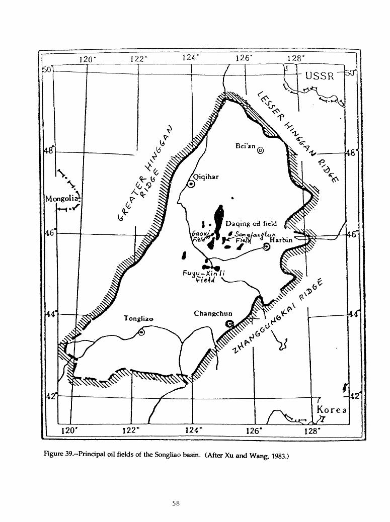
Figure 39.-Principal oil fields of the Songliao basin. (After Xu and Wang, 1983.)
58

Figure 40.-Oil pools in different types of traps in the Putaohua reservoir of the north-central Somdiao basin. (After Ma, 1985.)
1, structural contours; mb.sJ.; 2, structural pools; 3, combination pools; 4, stratigraphic pools.
59

Figure 41. Fuyu-Xinli oil field, Songliao basin. (After Ma and others, 1988.)
I, productive area; 2, structural contours; m b.s.l.; 3, fault.
60

',00 -
Figure 42. Cross section through the Fuyu field, Songliao basin. (After Ma and others, 1988.)
61

Source rocks of the basin are deep-lake deposits. They were extensively studied by Chinese geochemists as a prime example of source rocks of continental origin. Two main source rock intervals are in the lower Qingshankou Formation (member 1) and the lower Nanjiang Formation (member 1); they were deposited when the ancient lake reached its maximum depths and extents. Black anoxic shales are also present at some other stratigraphic levels, but they are only locally developed and are of secondary importance. The TOC content of the black shales commonly exceeds 2%. The kerogen is of mixed type, however, type I, rich in lipids, greatly predominates (Yang and others, 1985).
The present geothermal gradient in major oil-producing areas of the basin is high; it averages 4.2°C/100 m and decreases to 3.5°C/100 m toward the basin margins. The ancient geothermal gradient was even higher and reached 5.6°C/100 m based on vitrinite reflectance data (Ma and others, 1989). The high geothermal gradient resulted in a shallow occurrence of the oil window; the top of the oil window is found at a depth of 1100-1300 m and its bottom (top of the gas window) is at 2700-2900 m. The peak oil generation occurs at 1700-1900 m. Oil generation in the deepest depressions could have begun as early as time of deposition of the Nenjiang Formation (Yang and others, 1985), but the main oil generation probably took place during the latest Cretaceous. Some rocks of this age were probably removed by pre- Tertiary erosion.
Besides the middle Cretaceous sources, presently unstudied source rocks may be present in the Jurassic section that fills the rifts. Dark shales are present among Jurassic coal-bearing rocks and are believed to have an oil and gas-source potential (Ma and others, 1988,1989). The potential of these rocks as a source for oil is doubtful because of their coaly character and over-maturation throughout most of the basin. However, these rocks could have generated gas, and gas shows were recorded in some wells (fig. 31).
Reservoir properties of rocks in the main producing intervals of the middle Cretaceous vary significantly depending on facies characteristics of sandstones. The best reservoirs are associated with the main bodies of the progradational deltas deposited closer to the basin margins away from the area of source rock deposition. However, these sandstones are largely devoid of oil, probably due to the lack of seals and to flushing. Most oil production is from the transitional zone between the main part of a delta and the deep-lake source facies. Sandstones in this zone were deposited in distributary mouth bars, in channels, and as sand sheets in the delta front (Xu and Wang, 1983). Reservoir sandstones in this zone are interlayered by lacustrine shales that acted as seals and occur in contact or in close proximity to source rocks. Reservoirs are chiefly composed of feldspathic and graywacke sandstones. The loss of porosity with depth is significant and below 2-2.5 km, the reservoir properties are poor (Du and others, 1984). Farther into the paleo-lake, sandstone bodies are thin and erratically distributed; they are absent in central areas of the paleo-lake. Typical reservoir porosities in the oil fields are about 20% and permeabilities are a few tens to a few hundreds of millidarcies (Ma and others, 1988).
62

Oil pools in the main middle Cretaceous reservoirs are sealed by interlayered shales. However, the main regional seal is a shale in the second member of the Nenjiang Formation. This lacustrine shale, from 50 to 250 m thick, covers a variety of underlying fades over most of the basin area. The lacustrine shale that composes the first member of the Qingshankou Formation, one of the two major source rocks in the basin, also acts as a regional seal for the underlying Fuyu and Yangdachengzi reservoirs (fig. 31).
Structural traps control the majority of oil reserves of the basin, but many reservoirs are actually combination traps because extensions of oil pools in these reservoirs are controlled by lithologic changes. Fault planes also seal many pools as can be seen in the Fuyu (fig. 40) and Daqing (fig. 43) fields. Purely stratigraphic traps are also known, as, for example, in the Songfangtun field (figs. 39 and 44) in the Sanzhao depression east of the Daqing field (fig. 38).
The Songliao basin is a mature exploration area although data on the actual amount of exploration are not available. Many thousands of wells have been drilled and, although most are development wells, the number of wildcats is probably large. All significant structural traps in the middle Cretaceous section probably have been drilled and the largest fields have been found. However, the complex fades pattern of the delta systems presents numerous opportunities for exploration for stratigraphic traps outside of the structural uplifts. Most fields in these traps will be small, although their number may be significant. The total amount of reserves in these fields probably will not exceed several percent of those already discovered in the basin.
Published data suggest that there has been very little exploration for deeper Cretaceous reservoirs beneath the main producing intervals of the Qingshankou through Nenjiang Formations. Oil fields are known in the upper part of the Quantou Formation, but the oil migrated downward from the lower Qingshankou source rocks (Ma and others, 1988). Productivity of older stratigraphic units depends on the presence of deeper source rocks. It seems unlikely that significant oil-source rocks are present in the Lower Cretaceous section. Coal-bearing dastics in the Upper Jurassic rifts are probably adequate source rocks for gas, as confirmed by observed gas shows in wells. Probably, very little exploration has been done in these rifts, which occur at depths of 4-5 km and more. Poor reservoirs and especially the scarcity of seals are limiting factors that will affect the productivity of this section.
63
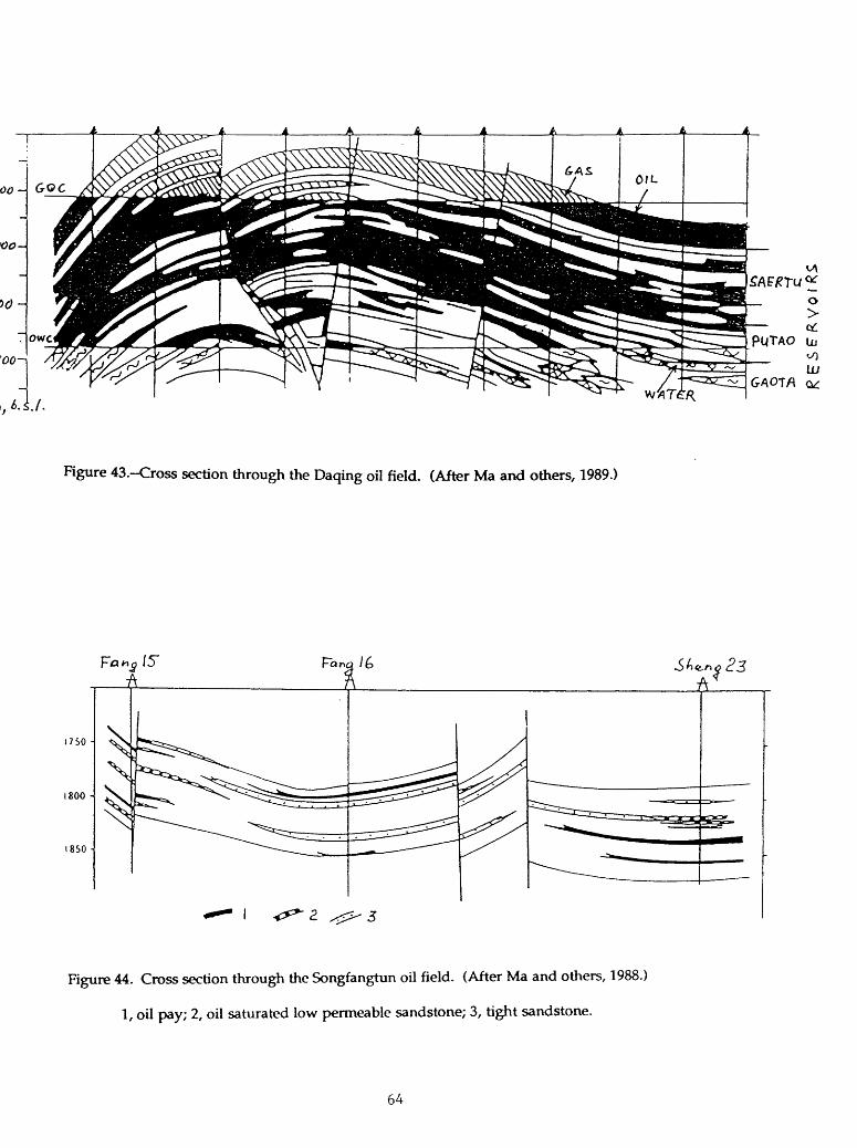
Figure 43.-Cross section through the Daqing oil field. (After Ma and others, 1989.)
1750 -
1800 -
1850 -
Figure 44. Cross section through the Songfangtun oil field. (After Ma and others, 1988.)
1, oil pay; 2, oil saturated low permeable sandstone; 3, tight sandstone.
64

NORTH CHINA BASIN
INTRODUCTION
The North China (Bohai Gulf, Bohaiwan) basin (fig. 45) is in the eastern part of the Sino-Korean craton. The basin area is 196,000 km2 (76,500 mi2). On the north, west, and south, the basin is bounded by the Yanshan foldbelt and the Taihang and Taikang uplifts respectively. The Luxi uplift flanks the southeast side of the basin. On the east, the basin boundary is a system of faults, including the large Tanlu strike-slip fault. The basin extends partly offshore, occupying shallow waters of the Bohai Gulf.
For many years, the North China basin has been a major oil producing basin in China, second only to the Songliao Basin. Oil was first discovered in the early 1960's in the Shengli productive area of the Jiyang depression. At present, this area is the second (after the Daqing field) largest producer in China; in 1989, it produced at a rate of 664,000 b/d. This constitutes about two-thirds of production from the North China basin.
STRATIGRAPHY
The Archean-Early Proterozoic basement is overlain by a poorly known Middle-Late Proterozoic sequence. Sinian carbonate rocks, consisting dominantly of stromatolitic dolomite, occur at the top of this sequence. Several hundred meters of these dolomites have been penetrated by wells drilled in depressions of the North China Basin.
The Paleozoic section of the basin is similar to the Paleozoic section of the western areas of the Sino-Korean craton. Lower Cambrian siliciclastic rocks unconformably overlie the Proterozoic and grade upward into Middle-Upper Cambrian shallow-water, partly oolitic carbonates. The Lower-Middle Ordovician is composed of limestones and dolomites containing gypsum beds in the upper part of the section. Sedimentation during early Paleozoic time occurred in platform conditions; thickness of these rocks reaches 1.5 km in the south part of the basin and decreases to a few hundred meters northward (figs. 46, A and B). Sinian and lower Paleozoic rocks, especially carbonates, constitute important reservoirs in the "buried hill" structures.
Uplift at end of Middle Ordovician time exposed the North China basin as well as the entire Sino-Korean craton to subaerial erosion. Sedimentation did not resume until Middle Carboniferous time. The Carboniferous-Permian section consists of a paralic coal measure that grades upward into red beds with some evaporates. Thickness of the upper Paleozoic section is commonly several hundred meters (figs. 46, C and D), but in places, it may reach as much as 1,500 m (Hu and others, 1989) mainly due to thickening of the red beds.
65

* , x / it -wt v l /s t__ /T
LQda
Teikang upland
EXPLANATION
Uplifted area
Basin boundary
Boundary of structural unit Dashed where approximately located, dotted where Inferred
0 100 200 300 KILOMETERS 1_______I_______I______|
Figure 45.-Main structural units of the North China basin. (After Lee, 1989.)
66

Figure 46.-Restored thickness of Cambrian (A), Ordovician (B), Carboniferous (c), and Permian Shihezi Formation (D) rocks of the North China basin. (After Li, 1983b.)'
67

The thick (to 1,000 m) Triassic section is known only on the southwest of the basin where it is composed of red elastics. Only a few wells penetrated thin Triassic rocks north of this area. Commonly, the Triassic is absent due to either nondeposition or later erosion (Zhang, 1985).
The Jurassic-Cretaceous stratigraphy is also poorly known because a very limited number of wells penetrated significant (several hundred meters) thickness of these rocks (Zhang, 1985). According to available data, the Lower-Middle Jurassic in different areas of the basin is formed by either coal-bearing, commonly tuffaceous, clastic rocks or thick volcanics (Hu and others, 1989). Structures in Upper Jurassic- Cretaceous rocks are different from those in the Lower-Middle Jurassic. The rocks are gray and dark-red elastics and abundant volcanics. The thickness of Upper Jurassic-Lower Cretaceous rocks varies greatly in different fault blocks and may be as large as 4 km (fig. 47a).
Regional uplift and erosion during the Paleocene preceded the Tertiary stage of rifting that began in Eocene time. A description of the Tertiary sedimentary Figure 47a succession is shown in table 3. The facies and thicknesses of stratigraphic subdivisions of the Eocene-Oligocene section are controlled by synsedimentary rift development. The entire sequence consists of continental rocks. Coarse-grained facies are mainly confined to flanks of the grabens where clastic fans and deltas were formed. Basinward, these facies grade into fine-grained rocks deposited in lakes and on alluvial plains. Deep lacustrine facies intermittently appear among lacustrine rocks; most of them are concentrated in the Shahejie Formation, especially in its third member. The deep lacustrine rocks are characteristically enriched by organic matter and are the main source for hydrocarbon accumulations. The preservation of organic matter was primarily controlled by water stratification in saline and brackish lakes. Interbeds of gypsum and salt are abundant in the Eocene-Oligocene section, and in places, they form diapiric structures (Wang and others, 1985). Detailed models of facies distribution in rift basins of eastern China are described by Chen and others (1984).
Intensive rifting during Eocene and Oligocene time was accompanied by significant volcanic activity. Tuffaceous material is widespread in sedimentary rocks of this age and thick basalt flows are common in the lower part of the Kongdian Formation. Basalts are locally present also in younger units of the Eocene-Oligocene section, especially in the northeastern part of the basin.
The Neogene Guantao and Minghuashen Formations unconformably overlie various older rocks both in rifts and on intervening horsts and form a sag over the Eocene-Oligocene graben system. The thickness of the formations is rather even (fig. 47b) and ranges from 1 to 2 km over most of the basin area and to 3 km and more in the Bozhong depression. Coarse clastic rocks dominate in the lower part of the Neogene sequence and grade upward into alluvial shales and sandstones. Quaternary sands and gravel, 100-300 m thick, form a blanket of sediment on the surface.
68

A*eSus- :«w
?*«1
<33
Of
>s
Js« I-
Serwi
Mloccne-Pbocene
Eocene Ollcocene
For-M«fjM
c3 >x«A c
<xZ
Is 0 ?-5*5
2E
CuinlJO
Dongying
4J
~!>'.c2.VO
Kongdbn
Me*>- b<*-
i
z
3
4
TAic fcne5S
120-
300
800-
1.200
300-
1.000
100-
1.200
ISO-
600
400-
1.000
200- 500
300- 1.200
60- 1.900
L t 6Ao-f?«* v
YcUov/ clay and pale fjcy, pcyuh ycUo^ wnd and ^f»vcl bcdi
e-rownith yellow clay rock interbcddcd with clutonc and sandy conglomerate
Upper part: reddish brown cby rock inter bedded with light brown and greyish white sandstone and sandy conglomerate, lower pan: greyish green, greyish white massive undstonc ind sandy conglomerate
Jlark brown, brownish red and greyish green mudstonc interbcddcd with pale brown and greyish green sandstone.
&ey mudslonc intercalated with yellowish brown oil ihxk. greyish white dolomite and biolithitc.
Upper pan: greyish white gypsum and rock alt intercalated with grey mudslonc. and a few dolomite. middle and lower part: inter beds of brownish red mudslorve and siltstonc. intercalated with brownish grey sandstone and sandy conglomerate.
.Jfcaik grey mudsXonc intercalated with yellowish brown oil ihaJc, grey marl and greyish white dolomite
Upper part: greyish white gypsum and rock salt (not extensively distributed) intercalated with dark grey mudstonc. dolomite and yellowish brown oil shale, middle and lower pan: inteibcds of dark grey mudstonc and sandstone.
Upper and lower pan: interbeds of red. brownish rod mudstone. argillaceous si It stone and sandstone, middle part: greyish black mudstonc intercalated with greyish white sUtttonc and fine sandstone
Table 3.-Stratigraphy of the North China \*sta(2Ji**9t
69

Figure 47a.-Thickness of Upper Jurassic-Lower Cretaceous rocks of the North China basin. (After Hu and others, 1989.)
70

Figure 47b.~Thickness (in kilometers) of Neogene rocks of the North China basin. (After Hu and others, 1989).)
71

TECTONICS
During the Paleozoic, the tectonic development of the area now occupied by the North China basin was very similar to that of the rest of the Sino-Korean craton. Gentle platform-type depressions and uplifts controlled the deposition. Long periods of non-deposition and subaerial exposure from Late Ordovician through Early Carboniferous time did not result in a significant angular unconformity and in change of the generally east-west structural trend.
The Early Kimmerian (Indosinian) deformation at the end of the Middle Triassic resulted in folding, local thrusting, and granite intrusions. The general structural grain of this phase of deformation had a northeast trend. The tectonic character of the following Late Triassic and Early-Middle Jurassic deposition remains unclear. Li (1983b) and Zhang and others (1983) suggest that rifting began during this time. However, a model of clastic and volcanic molasse deposition in post- deformational subsiding blocks and intermontane basins (Hu and others, 1989) seems more probable.
The tensional regime and widespread rifting began in Late Jurassic time and continued through the Early Cretaceous. The strike of the rift system was northeastern to north-northeastern, similar to the younger Tertiary rifts. The rifting event was not confined to the North China basin, but embraced large areas of Mongolia and southern Siberia (Zhang and Zhang, 1988). Volcanic material played an important role in sedimentary filling of the rifts.
The Late Jurassic-Early Cretaceous rifting apparently was not followed by a significant sagging stage. Possibly, the sagging could have begun in the Late Cretaceous. A few tens of meters of Upper Cretaceous clastic rocks unconformably overlie Lower Cretaceous elastics and volcanics. A deformation event in the Late Cretaceous (?)-Paleocene resulted in compression, regional uplift, and folding of Mesozoic rocks. Sinistral transpression and wrenching are believed to have resulted in echelon folding (Liu, 1986).
The Eocene-Oligocene rifting stage inherited the general northeastern structural grain of the Mesozoic rifts. However, particular Tertiary and Mesozoic grabens do not necessarily coincide. The rifting is believed to have been caused by a mantle plume, which seems to be confirmed by a high heat flow and thinned continental crust beneath the rift system (Lee, 1989). The Eocene-Oligocene rifting stage was followed by sag subsidence that began in Miocene time and evidently continues at present.
The present-day basin structure consists of more than 60 separate grabens. Most of them are half grabens (wedge-shaped, or dustpan-shaped depressions of Chinese geologists), but some are more or less symmetrical grabens with faults on both sides. Normal faults that control half grabens are synsedimentary and listric in shape. Facies characteristics of synrift sedimentary rocks may change from graben to
72
graben; actually, each graben represents a separate sedimentary and petroleum system. Seven depressions (subbasins), each consisting of a number of grabens, are recognized (fig. 45). Six of these depressions are productive; oil and gas have not been found only in the Linqing depression. The depressions are separated by uplifts on top of which the Paleogene section is absent. Smaller horsts with thin or no Paleogene rocks separate individual grabens.
PETROLEUM GEOLOGY AND POTENTIAL EXPLORATION PLAYS
The petroleum geology of the North China basin is complex because the basin consists of a large number of laterally disconnected petroleum systems. Despite many similarities in the structural development of the different grabens, local characteristics of sedimentary environments resulted in different facies and dissimilar distribution of both source rocks and reservoir rocks.
The main source rocks in the basin are deep-lacustrine shales deposited under anoxic or suboxic conditions on the lake bottom under a stratified water column. Both variations in salinity and temperature could have resulted in the stratification. The TOC content in the shales is not very high and averages about 2%; however, the kerogen in the organic matter is rich in hydrogen (dominantly of type I). High heat flow and geothermal gradient (average 3.4°/100m) enhanced the early maturation of organic matter at rather shallow (about 2,700 m) depth. Most source rocks are concentrated in the Oligocene Shahejie Formation and are mature. Geochemical data suggest that some gas could also have been generated from coaly source rocks of Carboniferous-Permian age (Zhou and others, 1988; Zhu and Xu, 1988).
Reservoir rocks in the basin are clastic rocks of various origin (fluvial, deltaic, lakeshore, clastic fans, turbidites) in the Eocene through Miocene section. Also productive in this section are fresh-water carbonates. Important production in the basin also comes from the weathered top portion of various pre-Tertiary rocks, from the Proterozoic to the Mesozoic, in the "buried hill" structures. Factors controlling reservoir properties of rocks in these structures are reviewed in Zhai and Zha (1982). Reservoirs of the basin are sealed by shales and evaporates in the Paleogene synrift sequence; however, the main regional seal that covers the entire basin area is the upper Miocene-Pliocene Minghuashen Formation composed of shales with some layers of coarser clastic rocks.
A variety of traps structural, stratigraphic, and a combination of these are productive in the basin. A review and classification of traps are provided by Li (1983b) who recognizes four main types: structural, combination, stratigraphic, and buried-hill traps. All trap types include a number of subtypes, each of which is controlled by a major structural and/or stratigraphic feature (e.g., roll-over anticline, updip pinch out, fault-sealed block, et cetera).
73
The following is a concise review of the six productive depressions (subbasins of the North China basin. The seventh, Linqing, depression does not contain oil and gas fields. The reasons for the lack of production in this depression are not clear beacase almost no data are present in the literature. Relatively thin and partially eroded Cenozoic rocks in this depression are underlain by thick Mesozoic sequences (Zhang, 1985).
The Dongpu-Kaifeng depression is in the southwest part of the basin (fig. 45). The depression is a horst-and-graben system about 7,000 km2 in area (fig. 48). In a cross section through the Wenliu field, the structure is basically formed by two grabens separated by a horst (fig. 49). Thickness of Tertiary rocks exceeds 5.5 km in the deepest grabens. The Tertiary is underlain by Mesozoic red beds about 1 km thick, by a Carboniferous-Permian coal measure, and by Cambrian-Ordovician carbonates (Zhu and Xu, 1988). The petroleum geology presented here is mainly after Lee (1989).
The main source rocks in the depression are shales and interlayered evaporites (salt and anhydrite) of the lower Shahejie Formation (Zhu and Xu, 1988). The thickness of the oil-generative part of the formation may reach 1,000 m. The oil window is located at a depth between 2,400 and 4,100 m. Based on isotopic data and thermal modeling, some dry gas in subsalt reservoirs in the Wenliu and Weicheng fields (figs. 50 and 51) is believed to have been generated by the Carbonifeous- Permian coal measure (Zhu and Xu, 1988; Zhou and others, 1988).
Reservoir rocks are sandstones in the synrift sequence, mainly in the two lower members of the Shahejie Formation. Oil and gas pools are sealed by evaporites. Most pools are controlled by faulted structural traps, but some of them seem to be located on monoclines and sealed by faults (Lee, 1989).
Gas dominates in hydrocarbon reserves of the Dongpu-Kaifeng depression. This may be due either to the additional charge of gas from Paleozoic coals or overmaturation of Tertiary source rocks in the deepest grabens where the base of the Shahejie Formation occurs at 5-6 km. Probably, the large amount of gas also is due to the presence of evaporite seals that prevented escape of gas through faults and fractures.
The largest fields are the Pucheng and Wenliu fields, both controlled by the central horst in the north-central part of the depression (figs. 48 to 50). Production from the Pucheng field was slightly less than 14 million barrels in 1983 (Lee, 1989).
No data on the amount of exploration in the depression are available. It seems likely that all significant structural traps associated with the central horst have been tested. Probably, much less exploration was targeted at stratigraphic traps, especially at pinch outs against the outer faults of the depression. The Baimiao gas field (fig. 48) is in a trap of this type. The southern part of the depression is reportedly less explored; gas is expected to dominate in undiscovered resources (Lee, 1989).
74

Linqing depression
Faulted boundary of primary sag
Secondary sag
Oilfield
Gas field
Oil and gas field
®Qingfeng
PuchenQ oil field
0 Puyang
Huzhuangj
10 20 X <0 KILOMETERS
Taikang upland
Rgure 48. Structural units and oil and gas fields of the Dongpu-Kaifeng depression, North China basin. (After Lee, 1989.)
75

w c
ME
TE
RS
Wenliu
oil
and
gas
field
E C'
2400
^-
Min
imu
m d
ep
th
for
ma
tura
tio
n
Oo
o
Figu
re 4
9.~C
ross
sec
tion
thro
ugh
the
Don
gpu-
Kai
feng
dep
ress
ion,
Nor
th C
hina
bas
in.
(Aft
er L
ee,
1989
.)
Loc
atio
n of
the
cros
s se
ctio
n is
sho
wn
in f
ig. 4
8. P
es 1
-4 s
tays
for
uni
ts 1
to
4 of
the
Pale
ogen
e Sh
ahej
ie
Form
atio
n. F
ed is
the
Don
gyin
g Fo
rmat
ion.

1000-
2000-
3000-
4000-
5000-
(M)
Figure 50.-Cross section through the Wenliu oil-gas field, North China basin. (After Zhu and Xu, 1988.)
Letter S with numbers indicate units and subunits of the Shahejie Formation. Ed is the Dongying Formation. 1, carbonate rocks; 2, evaporites; 3, coal-bearing rocks; 4, oil; 5, gas.
77

Figure 51.-Cross section through the Weichen oil-gas field, North China basin. (After Zhu and Xu, 1988.) For explanation see figure 50.
78

The Tizhong depression is in the northwestern part of the basin, just southeast of the Taihang uplift (Fig. 45). The area of the depression is 25,000 km2. The depression is an important oil producer; it contains the giant Renqiu oil field, the second largest field in the North China basin.
The depression consists of two chains of half grabens separated by the central uplifted zone (Fig. 52). Twelve individual grabens may be distinguished. All production is found in the southeastern zone of the grabens. The grabens northwest of the central uplift are nonproductive, supposedly because of the absence of adequate source rocks (Fig. 53).
Source rocks are deep-lacustrine shales with the TOC content varing from O.4 to a little more than 1 % and the hydrocarbon content of 250 to 700 ppm (Wu and Liang, 1988). Large thicknesses of source rocks reaching many hundreds of meters and a high expulsion efficiency owing to the close juxtaposition of source and reservoir rocks evidently make up for the relatively low richness of the source rocks. Most source rocks are concentrated in the third member of the Shahejie Formation, but they are present also in other parts of the section. Lower Cretaceous lacustrine shales (TOC 0.8-1.1%) and Carboniferous-Permian coal-bearing rocks are present in the pre-Tertiary sequence (Lee, 1989). Gas derived from the Carboniferous-Permian source rocks have been reported in some buried-hill pools, mainly in Ordovician carbonates (Dai and Xia, 1990).
Reservoir rocks in the depression are Tertiary elastics of various origin (deltaic fans, lakeshore beaches and bars, channel and turbidite sandstones). They are sealed by either shales or evaporites and are productive from a large variety of structural, fault-sealed, and stratigraphic traps (Wu and Liang, 1988; Li Disheng and others, 1988, Zha, 1984) (Fig. 54). Most petroleum reserves in the depression are in pre-Tertiary reservoirs in the buried-hill type structures. The best reservoir rocks are Proterozoic and lower Paleozoic carbonates (Zhai and Zha, 1982) with reservoir properties strongly enhanced by leaching, massive karstification, and fracturing (Fei and Wang, 1984). The two-billion-barrel Renqiu oil field produces from strongly fractured upper Proterozoic carbonates surrounded and overlain by source rocks of the Tertiary Shahejie Formation (fig. 55). Other lithologies at the eroded top of pre- Tertiary rocks have much poorer reservoir properties.
The Jizhong depression is maturely explored. At least 35 fields produce oil. The largest production is from the Renqiu field which produced more than 75 million barrels in 1985 (U.S. Energy Information Administration, 1987). A number of other buried-hill fields have been discovered. Although data on the amount of drilling are not available, it seems likely that the buried-hill play, as well as other structural plays in this depression, have been thoroughly explored.
79

Rgure 52,-Stmctural units and oil fields of the Jizhong depression, North China basin. (After Wu and Liang, 1988.)
1, limit of Lower Tertiary rocks; 2, oil field in Tertiary rocks; 3, oil field in pre-Tertiary rocks of buried hill; 4, fault.
80

Figure 53.-Distribution of Lower Tertiary source rocks and related oil fields in the Jizhong depression, North China basin. (After Wu and Liang, 1988.)
1, oil field; 2, outline of mature source rocks; 3, isolines of quantity of generated oil in 10,000 tons
per km2; 4, limit of source rocks; 5, fault.
81

v v - BasaK
Figure 54.-Types of oil and gas pools in the Langfang-Guan sag of the Jizhong depression, North China basin. (After Li and others, 1988.)
82

Figure 55. Cross section through the Renqiu oil field, North China basin- (After Yan and Zhai, 1981.)
Ek,Kongadian Formation; Es, Shahejie Formation; Ed, Dongying Formation; N, Neogene.
83

The Huanghua depression is in the central part of the North China basin, between the Jizhong depression to the northwest and the Jiyang depression to the southeast (fig. 45). The Huanghua depression consists of eight half-grabens. The northeastern area of the depression lies offshore in the Bohai Gulf (Fig. 56). Thickness of Tertiary rocks in the deepest grabens of the depression may exceed 8 km of which Paleogene rocks constitute about 5.5 km.
Principal source rocks in the depression are deep-water saline lake beds in the three upper members of the Shahejie Formation and near the base of the overlying Dongying Formation. The TOC conent varies from 0.5 to 2.8% and averages 1.26%. The maximum thickness of source rocks (to 1.5 km) is found in the Qikou and Bangiao grabens (sags in the terminology of Chinese geologists). The intervening Dagang uplift controls the principal oil fields in the depression known as the Dagong field complex. The complex consists of the Bangiao, Tangjiahe, Gangdong, and Gangxi fields shown in Fig. 56 (Lee, 1989). The combined oil productions from these fields exceeded 23 million barrels in 1985 (U.S. Energy Information Administration, 1987).
Tertiary silicilastic reservoirs contain the main oil reserves in the depression. Productive clastic rocks in the synrift Paleogene sequence are of various origin: clastic fans, turbidites, channel and beach sandstones. They are described in detail by Zhao and others (1988). They produce hydrocarbons from fault-block traps, rollover anticlines, erosional and synsedimentary pinch outs, and faulted anticlines with salt and/or mud-flow cores (Hu and Qiao, 1983). Important reservoirs are also present in post-rift Miocene rocks, especially in basal sandstones of the Guantao Formation, in drape structures over horsts. Smaller production is from lower Paleozoic carbonates in the buried-hill structures and from Paleogene bioclastic limestones.
The productive central depression area is densely explored. The absence of fields in the relatively shallow southwest part of the depression is probably due to the absence or poor development of source rocks. Some exploration offshore has been conducted by the Japan China Oil Development Corporation (JCODC), and by 1985, four wells had been drilled on the southern flank of the Qikou graben (Matsuzawa, 1988). One of these wells tested 2000 bid of oil from the Shahejie Formation at 2168-2184 m, but probably, the field has not been developed. The other three wells were dry.
The Tiyang depression is the principal oil producer in the North China basin. The depression is located southeast of the Huanghua subbasin, north of the Luxi uplift (fig. 45). The depression area is 17,000 km2 onshore and about half as much offshore. A system of central uplifts separates the deepest part of the depression, the Dongying sag (5,700 km2), on the southeast from the Zhanhua and Chezhen sags on the north and the Huimin sag on the west (Fig. 57). The Dongying sag is probaly the best studied structure in the North China basin. The sag is a half graben tilted northward toward the central uplifts. Thickness of the Tertiary sequence exceeds 7 km.
84

Van Shan (old bell
Secondary sag
Oilfield
Depression f^uU boundary
o
Linqing depression
Figure 56. Structural units and oil and gas fields of the Huanghua depression, North China basin. (After Lee, 1989.)
85

00
Upl
ift
Bur
ied-
hill
oil
field
Oil
and
gas
field
Fau
ltG
udao
oil
field
//W
e/
BO
H
A1
Pin
gfan
gwan
g oi
l an
d ga
s fie
ld
Box
ing
oil
and
gas
field
Figu
re 5
7.-S
truc
tura
l un
its
and
oil
and
gas
fiel
ds o
f th
e Ji
yang
dep
ress
ion,
Nor
th C
hina
bas
in.
(Aft
er L
ee,
1989
.)

The principal source rocks are located in the third and first members of the Shahejie Formation. The average geothermal gradient is 36°C/km and the oil window is at 2,200 to 3,000 m. Main production in the basin is from Tertiary elastics of both synrift (Paleogene) and postrift (Neogene) sections. Also productive are Tertiary carbonate bank limestones and Ordovician carbonates in the buried-hill structures. The distribution of source and reservoir rock facies in the Dongying sag is shown in fig 58. These facies are typical (with certain variations) of all Paleogene grabens of the basin.
The well known "Shengli field", the second largest oil producer in China (after the Daqing field), is in the Jiyang depression. Actually, the Shengli is not a field, but is a large producing complex which includes 59 oil and gas fields (Scott, 1990). Forty eight of these fields are on production; in 1989, they produced 664,000 b/d. Most fields are in the central and northern Dongying sag, in the Zhanhua sag, and on the flanks of adjacent uplifts (figs. 57 and 59). The largest fields of the complex are the Shengtuo (3.7 billion barrels), Gudao (2.5 billion barrels), and Gudong (1.6 billion barrels) fields. Probably, the numbers represent in-place resources. A major offshore discovery was reportedly made in 1988.
A large variety of trap types, both structural and stratigraphic, control the oil fields. Structural fields dominate; they contain about 77.5% of oil reserves of the Jiyang depression (Shaui and others, 1988). The structural traps are primarily tilted fault blocks and overlying drape anticlines (fig. 60). Anticlinal structures with a diapiric cores (shale or salt) are also important (Wang and others, 1985). Among stratigraphic pools, those that are found immediately below and above unconformites are the largest; these pools account for more than three-quarters of the reserves in stratigraphic traps. An example of a pool in strata overlapping the unconformity is shown in fig 61. Pools in other types of stratigraphic traps (seven of them are described in Shaui and others, 1988), including buried-hill pools, are far less important in the Jiyang depression.
The onshore portion of the Jiyang subbasin is probably very maturely explored. More than 2,000 wells are drilled annually, about 250 of them are exploratory holes (Scott, 1990). A large variety of stratigraphic traps, many of which are subtle (Ma and others, 1982), suggest that discoveries will continue for a long time. However, only a relatively small fraction of already discovered oil can probably be added to the reserve base. No data on the amount of offshore exploration are available. The offshore area of the subbasin is probably explored much less, and significant discoveries can be expected, especially in the offshore continuation of the Zhanhua sag in which the presence of rich source rocks has been proved.
The Bozhong depression is almost completely offshore in the Bohai Gulf. It is northeast of the Jiyang depression and is bounded on the southeast by the Tanlu fault system (fig. 45). The area of the depression is approximately 16,000 km2 .
87

oo 00
8
Figu
re 5
8.-F
acie
s of
the
Sha
hejie
For
mat
ion
in t
he D
ongy
ing
sag
of t
he J
iyan
g de
pres
sion
, N
orth
Chi
na b
asin
. (A
fter
Hu
and
othe
rs, 1
989.
) Sj
to
S4 d
enot
e m
embe
rs o
f th
e Sh
ahej
ie F
orm
atio
n.
1, g
ypsu
m;
2, m
icri
tic l
imes
tone
; 3,
det
rita
l lim
esto
ne;
4r d
eep
lake
; 5,
mod
erat
ely
deep
lak
e or
pr
odel
ta;
6, s
hallo
w l
ake;
7,
allu
vial
con
e; 8
, la
ke-f
loor
fan
; 9,
del
ta;
10,
dire
ctio
n of
tr
ansp
orta
tion
of c
last
ic m
ater
ial.

DAWANGZHUANG 7H,, AfjfiXiCHENGDONG 80/7a/GUff
WUHAOZHUANG
CHANGDI
GUNAN
GUDONG
HONGLIU
k XINTAN
Laizhou Bay
DONGXIN
,NGLI
_ WANGJIAGANG
QIA02HUANG
CHUNHUA
BOXING
LINPAN
WEIBEI
o Yucheng
o Jinan
Figure 59.-CH1 field* of the Shengli producing complex. (After Scott, 1990.)
89

NW
A
SE
A'
o
ME
TE
RS
0
1000
20
00
3000
40
00
5000
Gpdao o
il fie
ld
N
2200-*
-
Min
imu
m
depth
for
matu
ration
Figu
re 6
0.~C
ross
sec
tion
thro
ugh
the
Gud
ao o
il fie
ld i
n th
e Ji
yang
dep
ress
ion,
Nor
th
Chi
na b
asin
. (A
fter
Lee
, 198
9.)
PeSj
to
PeS4
den
otes
fir
st t
o fo
urth
mem
bers
of
the
Sha
hejie
For
mat
ion.
Lt>
ca.it<
>»
o[-t
u. c
ross
.scc
f»o^
U

A
I00(?
A'
Figure 61 .-Oil field in onlapping strata of the Shahejie Formation, S-G-S area of the Jiyang depression, North China basin. (After Shaui and others, 1988.)
91

Little information has been published on the geology of the Bozhong depression. By 1980, Chinese Bohai Oil Corporation had drilled about 40 wells in the Bohai Gulf. Since 1980, the offshore exploration was conducted by a joint venture, the Japan-China Oil Development Corporation (JCODC). By July of 1984, the JCODC had drilled 22 wells in the area, most of them in the Bozhong subbasin. The drilling results are described by Matsuzawa (1988). The main structural units offshore and locations of drilled wells offshore in the Bohai Gulf are shown in Fig. 62. The wells marked CFD in the northwestern corner of the map are in the Huanghua depression. The Chengbei field was discovered by Chinese in 1972. The field produces from a 25-m-thick sandstone in the Dongying Formation draping over a Mesozoic buried hill. It is not dear whether this field is located in the Bozhong or Huanghua depression.
The Paleogene Bozhong depression underlies the deepest part of the superjacent Miocene-Pliocene sag. Thickness of the sag sequence exceeds 3 km in the central trough (Bozhong depression of fig. 62). Therefore, the drilling was concentrated on the Bonan uplift where thickness of the Miocene-Pliocene section is approximately 2.5 km, and was targeted at buried hill structures. Among 12 drilled wildcats, oil was tested in 7, and 6 out of 10 appraisal wells yielded oil. All tests but one produced oil from Tertiary sandstones in drape anticlines over basement highs. Only the BZ-28-1 well tested oil from Cambrian-Ordovician carbonates of a buried hill. Yields of oil varied from 1,800 to 12,000 b/d.
Source rocks are located in the first and third members of the Shahejie Formation and also at the bottom of the overlying Dongying Formation. The oil window is in the depth interval of 2,000 to 4,700 m. Judging from high oil yields in the tests, the quality of the reservoir rocks is rather good.
The undiscovered petroleum potential of the Bozhong depression is probably high, but large drilling depths over much of the area will hamper exploration. A significant amount of gas may be expected in deeply buried traps because much of the source rocks should be overmature in the central areas of the depression.
The Liaohe depression, located northeast of the Bozhong depression, occupies the northeastern part of the North China basin along the lower reach of the Liao River and the adjacent Bohai Gulf (Liaodong Bay) (fig. 45). The area of the onshorepart of the Liaohe depression is 12,400 km2 . An area almost twice as large lies offshore. No information is available on this offshore portion of the depression, supposedly because of the lack of exploration.
A northeast trending central uplift marks the axis of the long (200 km) and narrow (65 km) onshore part of the depression (figs. 63 and 64). Archean granite underlies Tertiary rocks on the uplift. The Eastern and Western sags flank the uplift. The small (800 km2) Damintun sag is in the far northeastern corner of the depression.
92

lit'
Ta
ng
gu
OIK
OU
DE
PR
ES
SIO
N
Nan
bao N
AN
BA
O
DE
PR
ES
SIO
N
HA
IZH
ON
Q
UP
LIF
T
BO
ZH
ON
Q
SH
IJIN
TU
O
UP
LIF
T
/"
BO
ZH
ON
Q
DE
PR
ES
SIO
N
OIK
ouV
Chenobel"
""'
OIN
AN
U
PLIF
T
..,
O
ILF
Ield
J$,
£/1
.
9>
CH
EN
OZ
IKO
U
-..
^
.
. O
A "i
i*.
''
' U
PLIF
T
'-..
«J'o
.
8/J
Z-l
-l/t
BO
NA
N
°
/UP
LIF
T
-M
.
HU
AN
QH
EK
OU
" H
D
EP
RE
SS
ION
KE
ND
ON
O
UP
LIF
T
"o*
"'
0'
o°
! / M
IAO
XI
UP
LIF
T
vN^
Oil
W A
II
0
Dry
ho
lo
Figu
re 6
2.~S
truc
tura
l un
its o
f th
e B
ohai
Gul
f an
d dr
illed
wel
ls.
(Aft
er M
atsu
zaw
a, 1
988.
)
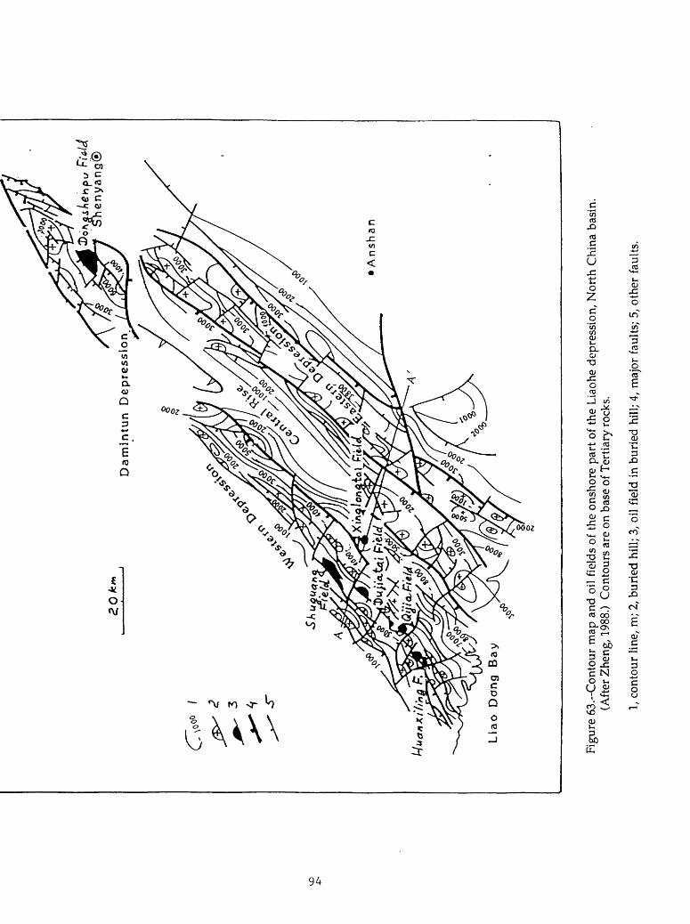
Dam
lntu
n
Dep
ress
ion
A
nsh
an
Lia
o
Don
g B
a
Figu
re 6
3.--
Con
tour
map
and
oil
field
s of
the
ons
hore
par
t of
the
Lia
ohe
depr
essi
on,
Nor
th C
hina
bas
in.
(Aft
er Z
heng
, 198
8.)
Con
tour
s ar
e on
bas
e of
Ter
tiary
roc
ks.
1, c
onto
ur li
ne,
m;
2, b
urie
d hi
ll; 3
, oil
fiel
d in
bur
ied
hill;
4,
maj
or f
aults
; 5,
oth
er f
aults
.

Sh
u
25
Gu
52
3X
lng
86
Leng
2
Figu
re 6
4.--
Cro
ss s
ectio
n th
roug
h th
e L
iaoh
e de
pres
sion
, N
orth
Chi
na b
asin
. (A
fter
Zhe
ng,
1988
.) L
ocat
ion
of th
e cr
oss
sect
ion
is s
how
n in
fig
ure
63.
My
deno
tes
Arc
hean
gra
nite
s; Z
, mid
dle
and
uppe
r Pr
oter
ozoi
c ro
cks;
Es
and
Ed a
re t
he
Shah
ejie
and
Don
gyin
g Fo
rmat
ions
cor
resp
ondi
ngly
.

Major oil reserves of the depression are in buried-hill structures. Tertiary elastics are also productive in stratigraphic traps along the northwestern margin of the depression and in drape structures over buried hills, but the reserves are significantly smaller. Reservoirs in the buried hills are weathered and fractured Archean granites, leached Upper Proterozoic carbonates and quartzites, and Jurassic- Cretaceous volcanics. A detailed description of the fields is available in Zheng (1988), Lee (1989), and U.S. Energy Information Administration (1987). Apparently, all the discovered fields are in the Western and Damintun sags. The reasons for lack of productivity in the Eastern sag and the offshore area are not clear; possibly, little exploration has been conducted in those areas. In 1985, a major new discovery (730 million barrels) in the Liaohe depression was announced (Oil and Gas Journal, 1985), but the location was not indicated. Probably, this discovery is not shown in figure 63.
Source rocks in the depression are mainly in the Shahejie Formation; as in the other depressions, they are deep lacustrine shales with the TOC content varying from 1.75 to 2.8%. The shales are present in all three sags onshore (fig. 65), and thus, the nonproductivity of the Eastern sag is not related to the absence of source rocks. The geothermal gradient in the Liaohe depression is higher than in otherdepressions of the North China basin, it varies from 33 to 46.5 °C/km (Lee, 1989). Therefore, the oil window is rather shallow; the zone of maximum oil generation occurs at 2,000-2,400m.
The Liaohe depression, especially its offshore part, seems to be less explored than the other depressions of the North China basin except for the Bozhong depression. From available data, the conditions of oil generation and entrapment seem to be good. Probably, the depression possesses a significant potential for undiscovered petroleum.
SummaryThe undiscovered petroleum potential of the North China basin is difficult to
evaluate based exclusively on published data. The difficulties are related to significant variations in stratigraphy (source rocks, reservoirs) and structure from one graben to another. Actually each graben (sag) is a separate petroleum system not connected with petroleum systems of the other grabens. Thus, stratigraphic, structural, and drilling data are needed for each graben to make a detailed resource assessment. These data are absent from the available literature.
The above discussion on six subbasins (depressions) of the North China basin suggests that four of these subbasins (Dongpu-Kaifeng, Jizhong, Haunghua, and Jiyang) are rather maturely explored. Probably, little oil remains to be found in large, easily mappable structural traps. Most of the future discoveries may be expected in subtle, chiefly stratigraphic, traps. Data on the most thoroughly explored Jiyang subbasin indicate that stratigraphic traps contain about one-quarter of its petroleum reserves. A part of these reserves in stratigraphic traps remains to be discovered in the other three subbasins.
96

Figu
re 6
5.--
Faci
es o
f th
e th
ird
mem
ber
of t
he S
hahe
jie F
orm
atio
n in
the
Lia
ohe
depr
essi
on,
Nor
th C
hina
bas
in.
(Aft
er
Hu,
198
5.)
The
dee
p la
cust
rine
fad
es is
the
mai
n so
urce
roc
k.
1, d
eep
lacu
stri
ne f
acie
s; 2
, sh
allo
w l
acus
trin
e fa
cies
; 3,
flu
vial
pla
in f
ac i
es;
4, l
imit
of r
ocks
of
the
thir
d m
embe
r of
the
Shah
ejie
For
mat
ion;
5, b
asin
bou
ndar
y.

The Bozhong and offshore Liaohe subbasins are probably very lightly explored. Significant new discoveries may be expected in both subbasins. No data are available on the geology of the Linqing subbasin. Apparently, no exploration is being conducted there. The lack of exploration and the absence of discoveries probably suggest that there is little or no petroleum potential in the subbasin. Original recoverable oil reserves in the North China basin are believed to be 13-14 billion barrels. Reserves of gas are comparatively small (about 8 TCP). Undiscovered hydrocarbon resources will probably amount to about 30-40% of those already discovered.
98

NANXIANG BASIN
INTRODUCTION
The Nanxiang basin is located in the southern Henan Province southwest of the North China basin and north of the Jianghan basin (fig. 1). On the northwest, northeast, and southeast, the basin is bounded by mountain ranges, the Qinling, Funiu, and Tongbai Mountains respectively (fig. 66). On the southwest, the Xinye uplift separates the basin from the shallow nonproductive Xiangfan and Zaoyang depressions.
The basin consists of two depressions (subbasins): the Biyang (in some publications, Miyang) depression on the east and the larger Nanyang depression on the west. The depressions are separated by the Tanghe uplift. Published data are limited to the Biyang depression which contains the bulk of the basin's oil reserves. Therefore, the following description concerns the Biyang depression; the geology and petroleum potential of the Nanyang depression are assumed to be similar to those of Biyang.
Exploration in the basin began in 1974 and the largest field of the basin, the Shuanghe field (fig. 66), was discovered in 1976. By 1979, the oil production in the basin reached its maximum of about 40,000 b/d (Hu, 1985)
STRATIGRAPHY
The basin's sedimentary fill is as thick as 8 km in the depocenter near the southern boundary fault. The Tertiary sequence is shown in figure 67; presently unknown Upper Cretaceous rocks may occur between the Proterozoic basement and the Tertiary (Li Chunju and others, 1988).
The Paleocene-Eocene section is 3-4 km thick and consists of fluviolacustrine red-colored elastics. Unlike in the Jianghan basin to the south, the Eocene does not contain organic-rich deep-lake facies. In the Biyang depression, these facies appear in the third member of the Oligocene Hetaoyuan Formation. This member contains both the source rocks and the major reservoirs of the basin. Paleogeography and depositional environments of the rocks were studied in great detail by Li Chunju and others, 1988 and by Zhu, Shuian and others (1981). The association of deep-lake black shales in the depression center and sandstone bodies of deltaic, turbiditic, and other origin on the margins (fig. 68) resulted in favorable conditions for oil entrapment.
Two younger members of the Hetaoyuan Formation and the overlying lower part of the upper Oligocene Liaozhuang Formation reflect gradual shallowing, shrinking, and final dessication of the lake. The rocks are various elastics of shallow lake to alluvial origin. Evaporites (mainly gypsum) in the upper Liaozhuang Formation indicate that deposition occurred in a brackish-water to saline lake.
99

Figure 66.-Main structural units and oil fields of the Nanxiang basin. (After U.S. Energy Information Administration, 1987.)
100

Brownish-yellou;
andothercolors
<£D I Calcareous sediments
Gypsum
Gypsum crystals in sediments
Gypsum vein
Figure 67.-Tertiary stratigraphy and fades of the Biyang depression. (After Li u cW dU&rs,
101

© Tangh*' ^ r. .7:.-'',<-'. x ' ' .,' * v, . y » . ° Xiaercnen.-.-/-. < .-y
.- /' W
\'/S) Anpeng'/ o Shuanghe^K^rv-:-. ^::;
; \^^-i»-.--Pi,,gzhi o-] ^ ^f~° , -
Yangqiao. ° Liyuan
Figure 68. Sedimentary facies of the 3rd member of the Hetaoyuan Formation in the Biyang depression. (After Li, Zhu, and Zhu, 1988.)
1, subaqueous fluvial fan; 2, subaqueous gravity-slide sediments, 3, sand sheet; 4, deltaic fan; 5, delta; 6, turbidites; 7, mudflow cone; 8, barrier bar.
102

Pre-Neogene uplift and erosion were strongly expressed in the Nanxiang basin. In the northern part of the Biyang depression, Neogene sediments unconformably overlie various older rocks up to the third member of the Hetaoyuan Formation. The Neogene sag sequence is only about 200 m thick and consists of loose sand and clay.
TECTONICS
The Nanxiang rift was initiated at the end of Late Cretaceous or in the beginning of Tertiary time. The rifting began earlier than in the Tertiary North China basin to the north and later than in the Late Cretaceous Jianghan basin to the south. Unlike the North China and Jianghan basins in which two consecutive stages of rifting occurred, the Nanxiang basin developed in a single stage of rifting. Supposedly, the basin was formed on a Proterozoic metamorphic terrane cut by Mesozoic granites. These rocks are exposed in the adjacent Tongbai and Funiu Mountains and are covered by thin Neogene sediments on the Tanghe uplift.
Structurally, the Biyang depression is a simple half-graben with a great (5-7 km) downthrow along the southern and eastern boundary faults (fig. 69). From the deepest part of the depression near the faults, the basement surface gently rises northward and westward. Basically, the same simple regional structure is seen in a contour map on the top of the third member of the Hetaoyuan Formation (fig. 70). A few structural noses and a single roll-over anticline complicate the monocline.
The southern boundary fault evidently continues into the Nanyang depression. Presumably, general structural characteristics of this depression are similar to those of the Biyang depression.
PETROLEUM GEOLOGY AND EXPLORATION PLAYS
Four oil fields have been discovered in the Biyang depression. Total reserves of the fields are reported to be 104 million tons (760 million barrels) (Ma and others, 1982). This number probably indicates in-place resources (judging from a production rate of about 40,000 b/d). The largest field of the depression is the Shuanghe field (fig. 66) that contains 78% of the total reserves. The field is in an updip shale-out stratigraphic trap on a structural nose (fig. 71). The productive area of the field is 30 km2 . The reservoir rocks are sandstones of a subaqueous alluvial fan in the third member of the Hetaoyuan Formation. The average thickness of the sandstone beds is 60-70 m. Reservoir properties of the sandstones are probably rather good because the initial yields of wells range from a few hundred barrels a day to as much as 6,600 b/d.
Oil in the Xiaermen field is in a structural trap (rollover anticline) near the southeastern boundary fault (fig. 72). The field area is 4.3 km2 . Productive sandstones of the third and second members of the Hetaoyuan Formation were deposited in a delta. Two other fields of the Biyang depression are small; their
103

Figure 69. North-south cross section through the Biyang depression. (After Li. Chunju Location of the cross section is shown in Figure 70.
104

Figure 70.-Contour map on top of the third member of the Hetaoyuan Formation, Biyang depression. (After Li Cfocty u~ a*# others ̂ (<?&&}
\, oil field; 2, fault; 3, drillhole.
105

H-J 135" 1 ' < MM Big
Figure 71. Cross section through the Shuanghe oil field, Biyang depression, (after L» C^un^u ^, 1988). Location of the cross section is shown in Figure 73.
Figure 72.-Cross section through the Xiaermen oil field, Biyang depression.(After #q; /WJ.
106

productive areas are 2.5 and 3.0 km2 . The Wangji field is not in production. No data on fields of the Nanyang depression are available. Probably, all three discovered fields (fig. 66) are small.
Oils in the Biyang depression are characterized by an extremely high paraffin content (19-42%) and a high pour point (to 43°C). This causes severe testing and production problems (Hu, 1985).
Source rocks of the Biyang depression are deep-water lacustrine shales in the third member of the Hetaoyuan Formation (fig. 73). Thickness of the shales ranges from several hundreds to 1,300 m (Li Chunju and others, 1988). Unlike in the Jianghan basin, no signs of high salinity of the lake water are present. The TOC content is relatively high; it averages 1.66% as indicated by Li Chunju and others (1988) or 1.18% as indicated by Hu (1985). The kerogen is of dominantly sapropelic type. The mass-balance calculations (Ma and others, 1982) show that 260 million tons of oil were expelled from the source rocks and from these 104 million tons were entrapped in the discovered fields. If these calculations are correct, the entrapment efficiency is 40% which is probably the highest known efficiency in the world. The geothermal gradient is high (41°C/km) and the threshold of oil generation is at a depth of 1800 m. Over 80% of the source rocks is mature (Li Chunju and others, 1988).
Reservoir rocks are deltaic and subaqueous alluvial fan sandstones. The main reservoir rocks are in the third member of the Hetaoyuan Formation, and thus, they are contemporaneous to, and interfinger with, source rocks. Such relationships resulted in the very high efficiency of entrapment. The sandstones are thickest on the depression margins, close to the sources of clastic material. The thickness decreases in the central area of the depression, in the deep-lake zone, where only fine-grained turbidite sandstones are present (fig. 73).
Due to the small size and simple structure of the Biyang depression, structural traps are uncommon. Only one such trap has been found (Xiaermen anticline). As a result, the main oil reserves are concentrated in stratigraphic traps.
The Biyang depression, considering its small size, is a very rich petroleum system. No data on the amount of drilling are available, but probably the depression is maturely explored. The stratigraphy and facies distribution are well studied, and the most potential areas for large stratigraphic accumulations have been tested. Some new stratigraphic pools can certainly be found, but their sizes will be small.
Almost no data are available for the Nanyang depression. Source rocks are obviously present as indicated by the discovered pools. It seems likely that the problem of this depression is the lack of reservoir rocks. Productive sandstones of the Biyang depression were derived from the metamorphic and granitic terrains of the Tonbai and Funiu Mountains. The sources of clastic material for the Nanyang depression only could have been the narrow Xinye uplift (assuming that the Xiangtan basin trapped clastic material from possible southern sources, figure 66),
107

o 00
Figu
re 7
3.~T
hick
ness
of
sour
ce r
ocks
and
res
ervo
ir r
ocks
in t
he th
ird
mem
ber
of t
he H
etao
yuan
For
mat
ion
in th
e B
iyan
g de
pres
sion
. (A
fter
Hu,
198
5.)
1, o
il fi
elds
; 2,
iso
pach
of
sand
ston
es;
3, i
sopa
ch o
f da
rk s
hale
s; 4
, dri
llhol
es;
5, d
irec
tion
of t
rans
port
atio
n of
cl
astic
sed
imen
ts.

and the Qinling Mountains. The latter are formed mainly by folded geosynclinal formations, such as volcanics and graywacke, that probably produced poor quality reservoir rocks in the Nanyang depression.
109

JIANGHAN AND DONGTING BASINS
INTRODUCTION
The Jianghan basin is located south of the North China basin in the Hubei Province (fig. 1). The basin is surrounded by exposures or shallow occurrences of pre-Cretaceous rocks (fig. 74). On the north, a shallow graben system connects the Jianghan basin with the previously discussed Nanxiang basin. The area of theJianghan basin is 28,000 km^. The Dongting basin (fig. 74) is about half as large. It is separated from the Jianghan basin by the Huayong uplift on the top of which the basement is exposed at the surface. Some authors consider the Dongting basin to be a part of the Jianghan basin (e.g., Lu, 1982). However, the stratigraphic successions in these two basins are different.
Drilling in the Jianghan basin began in 1959, and the first oil field (Wangchang) was discovered in 1961. In the Jianghan basin, all (or almost all)known oil fields are concentrated in the rather small (2,500 km^) Qianjiang depression. The oil production in the basin was about 30,000 b/d in 1985. No commericial discoveries have been made in the Dongting basin.
STRATIGRAPHY
The basement of the Jianghan basin consists of Precambrian crystalline rocks and of deformed and partly metamorphosed rocks of Sinian through Jurassic age. Lower Cretaceous rocks have never been drilled; supposedly, because thermal uplift and erosion occurred during this time (Xie and others, 1988).
Upper Cretaceous-Lower Paleogene rocks form the lower rift/sag complex. The Upper Cretaceous may be 3-4 km thick and mainly consists of red beds with gypsum and salt (table 4). The salt is interlayered with elastics and is no more than 400 m thick. The evaporite deposition continued into the Paleocene-middle Eocene Shashi, Xingouzui, and Jingsha Formations. The Xingouzui Formation (lower Eocene) includes organic-rich shales that are believed to be petroleum source rocks (Chen and others, 1988).
The second cycle of rifting and evaporite sedimentation began in early upper Eocene time (fourth member of the Qianjiang Formation). Thickness of this member exceeds 2,200 m and almost one-half of it is composed of salt. However, the areal extent of evaporites in this second cycle is much smaller; the evaporites are present only in the eastern depressions of the basin and reach their maximum thickness in the Qianjiang depression (fig. 74). The evaporites there are interlayered with deep-lake organic-rich shales that constitute the main source rocks of the basin (fig. 75). Northward and westward, evaporites grade into nearshore lacustrine elastics (fig. 76). The salt-bearing section reportedly contains a poor association of marine forams (Chen and others, 1989); this indicates that the lake had a connection
110

Sttiti graphic Sequence
System
Quaternary
.Neogenc
Eogenc
Crctaceoos
Scries
Holoccnc
Pleistocene
Pliocene
Miocene
Oligo-
ccnc
Eo-
ccnc
Upper
and
Middle
Lower
Upper
Middle
Lower
Palcocenc
Upper
Lower
Formation
Plain
Guanhuashi
Jtnghezhcn
Qianjiang
Jingsha
Xingouzui
Shashi
Member
1
Upper
Middle
Lower
2
3
4
Upper
Lower
Upper
Lower
Uthologic Character
Gray clay, sill, fine-grained sand, gravel
beds
Moolod oiudstonc with intercalated sand
stone and conglomerate
Dark -grey mudstooe and silutonc with
intercalated oil shale and glaubcritc-bcaring
mudstonc
Referred to as "mod-gypsum layer"; con
sists of gray to dark -gray mudjionc.
gypcum-fnudslonc. oil shale v/iih inter-
calatcd salt
Intercalation of gray mudnonc and silutonc
Intercalation of gypsum, salt, sandstone and
mudstonc. with some oolitic marlite
Consists of 24 rhythmic units, each com
posed of salt, gypsum -mudstonc. gjaubcritc
mudstone. oil-bearing mudstonc. marine
occasionally, silfy fine-grained sandstone
occurs at the bottoms of the units
Gray to dark-gray mudstonc, sDistonc and
oolitic marl lie; three rhythmic units and
two suites of sandstone
Consists of 14 rhythmic units, each com
posed of dark-gray mudstooe. gypsum -
mudstonc and salt, with some silry fine
grained sandstone
Gray and dark gray mudstone. glaubcritc-
mudstonc. salt, oil-bearing mudstonc and
silly fine-grained sandstone
Gray and dark-gray mudstone. gUubcriic-
mudstonc. salt, oil-bearing mudstonc
Brown-purple-red mudstonc. gypsum -
bearing mudstone and siltstone
Purple-rod and gray-green mudstonc. mud-
gypsum, gypsum -bearing siltsionc. oil-
bearing mudstone
Dark-gray and brown-red mudstonc. gyp
sum, gypsum-bearing mudstonc. siltstonc
Brown-purplc-rcd mudstonc. mud-gypsum.
salt, silutonc. gypsum, rod sandy mudstonc
with intercalated conglomerate
Thickncj!
(m)
5O-150
300-900
0-1000
12XM50
110-700
150-640
100-700
173-2218
600-1000
600-2000
200-1900
1200-2800
Table 4.-Stratigraphy of the Jianghan basin. (After Xie and others, 1988.)
Ill

Figure 74.~Main structural units of the Jianghan and Dongting basins. (After Lu, 1982.)
1, metamorphic basement rocks; 2, Sinian through Jurassic rocks; 3, Cretaceous-Lower Tertiary rocks; 4, Quaternary; 5, boundary of structural units.
112

Figure 75. Depositional fades of the Qianjiang Formation in the Jianghan basin. (After Chen and others, 1989.)
1, formation limits; 2, fault; 3, pinch out of sandstones; 4, deltas; 5, bay mudflat facies; 6, turbidites; 7, deep saline lake sediments; 8, fan and bar facies; 9, alluvial plain; 10, shallow saline lake shale; 11, shallow-lake nearshore shale; 12, banks and bars of shallow saline lake; 13, shallow-lake, fresh to brackish-water sediments
113

Figure 76.-Extent . of evaporites of the Qianjiang Formation in the Qianjiang depression. (After Xie and others, 198*.)
1, pinch out of sandstones; 2, direction of paleocurrent.
114

with the open sea on the east and suggests that influx of marine water was the source for the salt. Younger subdivisions of the Qianjiang Formation and the Oligocene section are thinner than the fourth member and are mostly formed by clastic rocks varying from alluvial plain to lacustrine in origin. Some evaporites are present throughout the sequence. This younger part of the upper Eocene-Oligocene section apparently contains organic-rich rocks only in its upper part.
Upper Tertiary and Quaternary rocks are thin in the Jianghan basin and form a flat-lying blanket unconformably overlying older faulted rocks.
The stratigraphy of the Dongting basin differs from that of the Jianghan basin in that only the lower, Upper Cretaceous-middle Eocene, rift/sag cycle is well developed. Evaporite rocks are apparently absent or thin. The cycle includes several tens to a few hundreds of meters of dark shales in the Paleocene Taoyuan Formation. Upper Eocene rocks are thin (a few hundred meters) as compared to the Jianghan basin. The Oligocene is absent in the Dongting basin, and the Eocene is unconformably overlain by thin Neogene and Quaternary sediments similar to those in the Jianghan basin.
TECTONICS
Both the Jianghan and Dongting basins were initiated during Late Cretaceous time as a rift system. The rifts formed on the heterogeneous terrane that consisted of basement rocks of the Yangtze craton and its Sinian through Jurassic sedimentary cover. The sedimentary rocks were significantly deformed at the end of Jurassic time. The rifts had a dominant northeastern trend that is similar to the trend of the Tertiary rifts of the North China basin. Downfaulting in the basins ceased by Eocene time; the lower Eocene Xingouzui Formation (and maybe the middle Eocene) fills a sag developed over this early rift system.
The second rifting event began in the middle or late Eocene. The rifting occurred only in the Jianghan basin and left intact the more southern area of the Dongting basin. The western to northwestern trends of faulting dominated at this second rifting stage, although northeastern elements were also present in the structural pattern (fig. 74). The rifting evidently continued to the end of the Oligocene. Miocene and younger sediments unconformably overlie Paleogene rocks in grabens and on horsts and fill a sag developed over the rift system.
The present-day structure of the Jianghan basin is dominated by the western to northwestern trend. The general structure of the basin is a half-graben with a steep faulted flank on the north and a monocline on the south (fig. 77). The basin is separated into several depressions by subordinate uplifts. The Qianjiang depression occupies the central position and is the deepest part of the basin. The basement occurs as deep as 10 km. Supposedly this Tertiary depression was formed over a Late Cretaceous depocenter (Lu, 1982). Salt flowage in the depression complicates its structure (fig. 78). The Dongting basin consists of a series of northeast-trending
115

Wan
gcha
nj?
salt
do
me d
\t\9
c\£*
uAV.
Figu
re 7
7.-C
ross
sec
tion
thro
ugh
the
Qia
njia
ng d
epre
ssio
n of
the
Jian
ghan
bas
in.
(Aft
er C
hen
and
othe
rs,
1989
.)

Figure 78.~Salt domes in the Qianjiang depression. (After Xie and others, 1988.)
1, salt domes; 2, syndines; 3, boundary of the depression, 4, fault
117
grabens and horsts that formed during the Late Cretaceous-Paleocene and remained basically unchanged during the Eocene-Oligocene tectonic stage.
PETROLEUM GEOLOGY AND EXPLORATION PLAYS
The commercial petroleum productivity of the Jianghan basin is largely, if not exclusively, confined to the Qianjiang depression with an area of only 2,500 km2. Several oil fields have been discovered in the depression and on slopes of the adjacent uplifts (fig. 79). The largest oil field is the Wangchang field which is controlled by a salt-dome structure. The oil is trapped in turbidite sandstones pinching out against the salt dome and in younger sandstones, in the draping structure over the salt. Productive stratigraphic traps are either updip pinch outs of sandstones (on the southern flank of the depression) or onlap on an unconformity surface (on the northern flank) (fig. 80). In addition, there is a number of oil pools (probably small) in fractured shale reservoirs (Ma and other, 1982), but detailed data are not available.
The oil in all commercial fields in the basin has been generated by upper Eocene source rocks, primarily in the fourth member of the Qianjiang Formation. The fields are in or just around the area containing these source rocks (fig. 79). The rocks were deposited in a deep part of the saline lake. Their thickness exceeds 2 km in the depocenter. The kerogen is of mixed sapropelic and humic types as indicated by biomarkers and microscopic examination (Xie and others, 1988). The TOC content is not particularly high and averages 0.61%; the content of hydrocarbons is 964 ppm. The geothermal gradient is low compared to other rift basins in eastern China because of the presence of thick salt; it varies from 23 to 30° C/km in evaporite sections and increases to 30-40° C/km in clastic formations (Xie and others, 1988; Jiang and Zhang, 1982). The threshold of oil generation is at a depth of 2,200 m and the peak of generation occurs at about 3,700 m.
Another source rock section may be present in the lower Eocene Xingouzui Formation, although references regarding the quality of these source rocks are contradictory (Chen and others, 1988,1989; Yuan and others, 1983) and no hard data are available. The possible presence of source rocks in the evaporite-bearing Upper Cretaceous section is suggested by Chen and others (1988), but has not been demonstrated by drilling. The presence of source rocks in the Dongting basin remains to be proven. Dark shales with TOC varying from 0.2 to 1.4% are known in the Paleocene Taoyuan Formation (correlative with the Shashi Formation of the Jianghan basin), but the hydrocarbon content is rather low (100-380 ppm). Some oil shows observed in the Dongting basin may be related to this source rock.
Similarly to other rift basins in China, oil in the Jianghan basin is produced from sandstone reservoirs of various origin. Most of the sandstones are concentrated in the northern part of the basin close to the sources of clastic material.
118

Figure 79.-CH1 fields of the Qianjiang depression. (After Zhai and others, 1988.)
1, main oil-generating area; 2, subordinate oil-generation area.
119
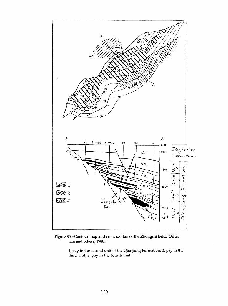
'1 2 16 4 17 60
Rgure 80.-Contour map and cross section of the Zhongshi field. (After Hu and others, 1988.)
1, pay in the second unit of the Qianjiang Formation; 2, pay third unit; 3, pay in the fourth unit.
in the
120

Deltaic, turbidite, alluvial plain, sand bar, and nearshore facies are present (figs. 75 and 76). Fractured mudstone reservoirs are known (Ma and others, 1982), but no further data are available.
The potential for significant new discoveries in the productive upper Eocene- Oligocene sequence of the Jianghan basin seems to be rather low. Although data on the amount of drilling are not available, one can suppose that the richest salt dome play in the Qianjiang depression has been thoroughly explored since the discovery of the Wangchang field in 1961. These structures have high closures (800 m in the Wangchang). They are relatively easy to map and are present in a limited area. Stratigraphic traps may be better exploration targets in the depression, but expected reserves should be small. The fields are less likely to be discovered on the southern basin margin because of the paucity of reservoir rocks.
Significant source rocks are absent from the upper Eocene-Oligocene sequence of the Jiangling depression (fig. 74) which is largely composed of alluvial elastics and does not contain salt. Thickness of this sequence in the Jiangling depression and also in the Xiaoban depression on the east is 1800-2200 m, which is probably insufficient for maturation (Xie and others, 1988). Only insignificant shows have been observed in exploratory holes in these depressions. The upper Eocene- Oligocene sequence is thin in the Dongting basin and does not have petroleum potential.
The petroleum potential of the Upper Cretaceous-middle Eocene sequence is more difficult to access. Probably, the sequence is significantly less explored than the younger rocks. The distribution, quality, and even the presence of adequate source rocks are uncertain. Source rocks may be associated with salt that is present over about one-half of the Jianghan basin. Maximum thickness, of the salt and probably the Cretaceous depocenter are situated in the Jiangling depression where salt tectonics is known. A few wells reportedly have produced oil flows in tests (Chen and others, 1989). Some source rocks are probably present in the lower Eocene.
Data on the reservoir quality of Upper Cretaceous-middle Eocene elastics are absent from the literature. Considering the molasse-type character of the red beds, rather poor reservoirs may be expected. Structural traps characteristic of rifts are prime exploration targets. The hydrocarbon potential of this sequence in the Dongting basin is probably lower. Evaporites are absent there and chances for the presence of adequate source rocks among the red beds are slim. Some oil shows were observed in tests in Paleocene rocks of the basin, but the geochemical characteristics of the possible source rocks (dark-gray shales of the Taoyuan Formation) seem to be poor.
Gas generation in deformed pre-Upper Cretaceous rocks (e.g., from Permian and/or Jurassic coals) and entrapment of gas below the Upper Cretaceous evaporite seal is possible, but highly speculative.
121

ERLIAN (CHINA) AND SOUTHEAST GOBI (MONGOLIA) BASINS
INTRODUCTION
The Erlian (Eren, Xiling) basin in northern China (fig. 81) and the Southeast Gobi (East Gobi) basin across the border in Mongolia (fig. 82) are two adjacent rift systems of Jurassic-Cretaceous age. Both basins developed on the Hercynian foldbelt north of the Sino-Korean craton. The area of the Erlian basin is approximately 220,000 km2, that of the Southeast Gobi basin is about half as much. Like other rift basins of China, both basins consist of a large number of individual grabens separated by horsts.
Very little data are available on the geology of either basin. Significant exploration efforts in the Erlian basin were probably undertaken in recent years, but almost nothing has been published. As reported by Oil and Gas Journal (1984), the undiscovered petroleum potential of the basin was believed to be rather high (7.3 billion barrels); since that article, at least two discoveries have been made (H.D. Klemme, personal communication).
Exploration for oil in the Southeast Gobi basin began in the 1940's in an area of surface seepages. The Dzunbain oil field was soon discovered. A state-owned oil company was formed in 1948. However, despite continuous exploration efforts, no new commercial discoveries have been made. Probably, very little exploration has been done during the last 15-20 years. At present, the Mongolian petroleum administration is trying to establish joint exploration enterprises with Western companies.
STRATIGRAPHY
A stratigraphic chart for the Erlian basin is shown in table 5. The Mesozoic section of the basin unconformably overlies various deformed and metamorphosed upper Paleozoic and older rocks of the Hercynian fold belt. The fold belt was formed by collision of the northern Mongolian Caledonian block with the Sino-Korean and Tarim cratons. No data on pre-Middle Jurassic Mesozoic rocks of the Erlian basin are available. In Mongolia, Mesozoic rifting began as early as in Late Triassic time, but rifts originating in the Early and Middle Jurassic are also known (Nagibina, 1970). The first stage of rifting was completed by the Late Jurassic. Thickness of the Upper Triassic- Middle Jurassic in rifts of eastern Mongolia ranges from 2 to 7 km. Continental lacustrine and alluvial, commonly coal-bearing rocks associated with volcanics dominate, but marine rocks are known in the extreme northeast part of the rift system. Early Mesozoic rifts are discordant to the trend of the late Paleozoic structure. The younger, Late Jurassic-Cretaceous, generation of rifts in Mongolia is also discordant relative to both late Paleozoic structures and early Mesozoic rifts. Large thickness of Middle Jurassic rocks in the Erlian basin, their occurrence outside the younger rifts directly on the Paleozoic basement (Fan and others, 1983), and the presence of volcanics in the lower part of the section may suggest their rift nature analogous to the early Mesozoic rifts of Mongolia; however, this supposition is not certain.
122

Table S.-Mesozoic and Cenojoic Stratigraphy of the Eriian Basin (Symbols are related to the local stratigraphic nomenclature)
LITHOLOGYTHICKNfcSS
(m) DISTRIBUTION
Sand, day, gravel, locally basalt 340
Mudslone, sandstone, conglomerate, Iccaty basalt 461 In depressions and party on uplifts
Mudslone, sandsione, ODngkxnerate 151 On (he west o< fie basin
Mudstone, sittstone, sandstone, conglomerate bads 274
Vihouguoto zone ot depressions
Basalt, andesite. tultaceous agglomerate 165-1215
Sandstone,conglomerate, sdtsione witnmudslone layers 392 675
Mudslone. sittsione, fine sandstone, localy coal beds 6061130
Widespread in the western pan ol the YftougUalei and HansharxJake toughs and adjacent area
Mudslone. siltstone, fine sandsione. nerbedsol conglomerate
32-540
IS Shale, interbeds ol coarse sandsione and conglomerate 465
s Shale, irterbeds ol oi shale, dolomite, sandstone, and gypsum 686
Sporadically present in the central and western parts ol the basin
Conglomerate with inlerbeds ol sandstone 417
Acidic tuft, tulfaceous agglomerate, zhyolite 187-2608
Basalt, andesite, basaltic tun 382-1129 widely
Acidic iu« with rnyolite and andesite 1470-3430
Sandstone, modstone, carbonaceous shale, coal beds 390
Sandsione and conglomerate 154
Sandsione. sdtsione, mudslone, coal beds 267
Sporadically distributed in the uplifted belt and on its margins
Conglomerate
Mudslone, shate. sandstone, thin beds ol marl >455
Mudslone, tuflaceous sandsione, lull, basalt 295Distributed in |he uplilleo Den and on its margins
TuH, coarse sandsione, silsione 328
Tutlaceous sandsione, sandsione. conglomerate, acidic tuft. Occurs unconlormabty on Permian granites
123
597

MONGOLIA
EXPLANATION
Boundaries of main structural units MAIN STRUCTURES:Main faultsGrabens I - Northern zone of upliftsShows in wells II - Yihuoquolei zone of depressionsShow on surface III - Central zone of upliftsDrilled wells V - Hunshandake zone of depressionIdentified deep-lake facies V- Southern zone of uplifts
Figure 81.-Late Mesozoic structure of the Erlian basin. (After Fan and others, 1983.)
124

Figu
re 8
2.--
Lat
e M
esoz
oic
stru
ctur
e of
sou
thea
ster
n M
ongo
lia (
Aft
er K
hasi
n an
d ot
hers
, 19
73):
1, la
te M
esoz
oic
and
Cen
ozoi
c de
pres
sion
s (1
-Tam
tsag
, 2-E
ast G
obi,
3-U
nege
tin, 4
-Dzu
nbai
n,
5-H
anbo
gdin
, 6-H
oloi
, 7-
Nem
eget
in, 8
-Sou
th G
obi,
9-D
linoo
zer)
; 2,
pre
-lat
e M
esoz
oic
rock
s,
part
ly b
enea
th U
pper
Cre
tace
ous
depo
sits
; 3,
dep
th t
o th
e fo
lded
bas
emen
t; 4,
are
as o
f C
enoz
oic
volc
anis
m; 5
, fau
lts in
upp
er M
esoz
oic
rock
s.
125

A new rifting stage in both the Erlian and Southeast Gobi basins began in the Late Jurassic and continued into the Cretaceous. In the Erlian basin, the early, volcanic, fill of the rift is very thick; it was formed during early Late Jurassic time (table 5). By late Late Jurassic time, the volcanic activity had largely ceased and continued subsidence in grabens was compensated by clastic deposition. The synrift clastic section of the Erlian basin consists of two formations, the Upper Jurassic Badalahu Formation and the Lower Cretaceous Bayanhua Formation. The formations are subdivided into members based mainly on the dominant grain size. Deep-lake organic-rich shales are abundant in the middle member of the Badalahu Formation and are also present in the upper member. They are associated with gypsum and some dolomites which suggest arid or semi-arid climate. In contrast, coals are widespread in the Bayanhua Formation indicating more humid environments.
Upper Cretaceous and younger rocks form the postrift sequence of the Erlian basin. They unconformably occur on various older rocks including the basement and are relatively thin. The maximum thickness (about 1,000 m) is known on the west of the basin. Basalt flows, locally rather thick, are common at the base of the section and are genetically connected with pre-Late Cretaceous uplift and erosion.
The Upper Jurassic-Lower Cretaceous synrift sequence of the Southeast Gobi basin overlies the Hercynian basement. Only on the northeast of Mongolia, in the Tamtsag basin (fig. 82), is this sequence underlain by Lower-Middle Jurassic coal- bearing elastics and volcanics of the Khamarkhuburin Formation. The synrift sequence of the Southeast Gobi basin begins with the Kimmeridgian-lower Valanginian (on other data Kimmeridgian-Tithonian - Shuvalov, 1969) Sharilin Formation (table 6). Coarse-grained clastic rocks dominate the composition of this formation. Finer-grained rocks including grayish-green lacustrine sandstones, effusive rocks, and basalt flows are present in the upper part of the section. Thickness of the formation may reach 1,500-2,000 m.
The upper Valanginian (or Tithonian-Valanginian) Tsagantsab Formation overlies the Sharilin red beds in grabens or basement rocks on flanks of the grabens and on horsts. The formation is to 1,000-1,200 m thick and is composed of volcanic material (basalt flows at the bottom and tuffs at the top) with interbeds of sandstones and shales. Sedimentation occurred in lakes and on alluvial plains in more humid climatic conditions (fig. 83).
Volcanics and elastics of the Tsagantsab Formation are conformably overlain by gray clastic rocks with a few volcanics of the Shinhuduk Formation (table 6). Decreased supply of clastic material at the beginning of deposition resulted in deepening of the lakes and widespread deposition of organic-rich bituminous shales (paper shales) in grabens. These paper shales are most probably the main source rock of the basin. Their thickness commonly does not exceed 100 m. Upward in the section, the paper shales pass into dark gray and gray shales with beds of sandstone
126

Tab
le 6
.-U
pper
Mes
ozoi
c st
rati
grap
hy o
f ea
ster
n M
ongo
lia.
UPPER
CRETAC.
00
D O LU CRETAC
LOWER
oo
oo cc ^
D
-f -5
_J
AG
E
AP
TI A
N-
ALB
IAN
HA
UT
ER
IVIA
N-
BA
RR
EM
IAN
UP
PE
R
VA
LA
NG
INIA
N
KIM
ME
RID
GIA
N-
L. V
ALA
NG
INIA
N
FO
RM
EA
ST
G
OB
I
NE
ME
GE
TIN
B
UR
UN
GO
IOT
B
AIN
SH
IRE
IN
SA
INS
HA
ND
IN
BA
RU
NB
AY
AN
KH
UK
HT
YK
SH
INH
UD
UK
TS
AG
AN
TS
AB
SH
AR
ILIN
KH
AM
AR
KH
UB
UR
IN
A
T
1 0
N
NO
RT
HE
AS
T
MO
NG
OL
IA
DZ
UN
BA
IN
SE
RIE
S
CH
OIB
AL
SA
N
SE
RIE
S
LIT
HO
LO
GY
Red
cl
ast
ic
rock
s
Gra
y an
d gre
enis
h
sandst
ones,
si
ltsto
ne
s,
shal
es
Gra
y sh
ales
an
d sa
ndst
ones,
b
itum
ino
us
pape
r
shal
es,
mar
ls,
few
vo
lcanic
ro
cks
Con
glom
erat
es
and
sandst
ones
at
base
, sa
nd
sto
ne
s an
d sh
ales
at
to
p; m
assi
ve
volc
anic
flo
ws
and
tuffs
noQ
C
Ocu
S 6
g
r a
1 n
6Q
C
laS
lIC
lO
CK
S,
a
I6W
yid
y
san
dst
on
e
and
shal
e be
ds
and
volc
anic
s at
to
p
Contin
enta
l g
ray,
co
ars
e-g
rain
ed
cla
stic
ro
cks,
co
al

Figure 83. Paleogeographic map of eastern Mongolia. Neocomian (Tsagantsab time) (After Martinson, 1982):
1-3, areas of denudation (1-low mountains, 2-hilly topography, 3-denudational plains); 4-6, areas of accumulation (4-lakes, 5-alluvial, lacustrine-alluvial, and lacustrine-proluvial plains, 6-volcanic relief, mainly basalt plateaus); 7, centers of volcanic eruptions; 8, thickness of sediments, m; 9, direction of sediment transportation (a-main, b-local); 10, inferred river valleys; 11, possible junction of lakes; 12, inferred channels; 13, fossil fauna; 14, fossil flora; 15, gypsum; 16, phosphorites; 17, oil.
128

and marl. These non-bituminous rocks constitute the bulk of the Shinhuduk Formation whose total thickness reaches 700-1,000 m.
Commonly, the Khukhtyk Formation (table 6) rests unconformably on older rocks. The formation consists of gray clastic rocks with rare coal and limestone layers. On flanks of the grabens, Khukhtyk lake deposits in places overlap pre- Neocomian rocks because of significant increases in lake areas (fig. 84). The Barunbayan Formation at the top of the Lower Cretaceous is characterized by an abrupt decrease in areas of lacustrine deposition and by the appearance of beds of red-colored elastics indicating a transition to arid environments of Late Cretaceous time (fig. 85).
Upper Cretaceous and Lower Tertiary rocks unconformably overlie elastics of the Khukhtyk and Barunbayan Formations in graben-rifts and basement rocks outside the grabens. Coarse red and variegated elastics alternate with less abundant shales. The Late Cretaceous deposition occurred mainly in numerous shallow- water oxic lakes (fig. 86). Based on dominant grain size and color, the Upper Cretaceous section is subdivided into four formations (table 6). Total thickness of the section does not exceed 500 m. Lower Tertiary sediments are thin and present locally.
A comparison of the stratigraphic successions of the Erlian and Southeast Gobi basins suggests certain similarities. In both basins, the rift development occurred during Late Jurassic-Early Cretaceous time. Upper Cretaceous and younger rocks occur near horizontally above the rifts and on intervening uplifts. The main difference is that the initial volcanic stage was expressed much stronger in the Erlian basin than in the Southeast Gobi basin and terminated earlier. However, this apparent difference may be due to uncertainties in the age determination of continental rocks.
TECTONICS
The late Mesozoic rifting stage began in Late Jurassic time in both the Erlian and Southeast Gobi basins. The rift system was formed on substrates that ranged from Hercynian basement to lower Mesozoic rocks. These latter rocks fill an earlier rift system in Mongolia (Khasin and others, 1973) and probably also in the Erlian basin of China judging from the abundance of volcanics in the Middle Jurassic section (table 5). Probably the Late Jurassic rifts were initiated simultaneously in both basins, but uncertainly exists because of difficulties in age determination. The initial stage of rifting was pronounced in the Erlian basin where basal volcanics are thousands of meters thick. Volcanism was more moderate in the Southeast Gobi basin and was preceded by dominantly clastic sedimentation (Sharilin Formation). The change from mostly volcanic deposition of the early rifting stage to clastic deposition of the late stage apparently occurred earlier (Late Jurassic) in the Erlian basin than in the Southeast Gobi basin (Valanginian).
129
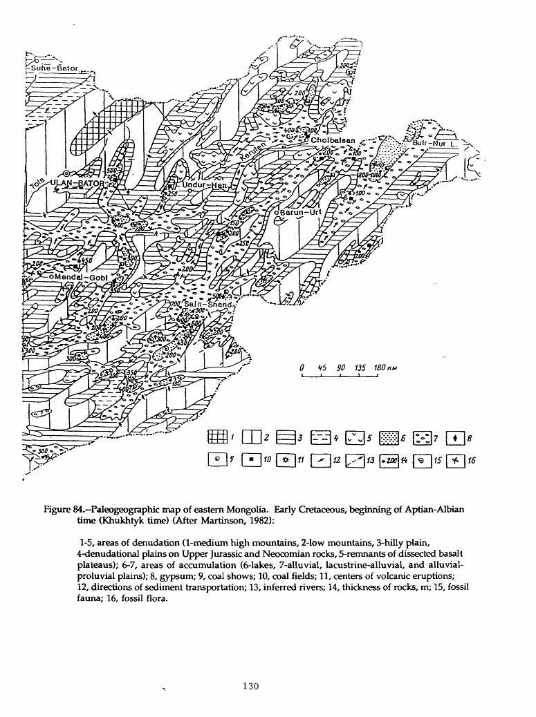
0 45 #7 735 750 A*
Figure 84. Paleogeographic map of eastern Mongolia. Early Cretaceous, beginning of Aptian-Albian time (Khukhtyk time) (After Martinson, 1982):
1-5, areas of denudation (1-medium high mountains, 2-low mountains, 3-hilly plain, 4-denudational plains on Upper Jurassic and Neocomian rocks, 5-remnants of dissected basalt plateaus); 6-7, areas of accumulation (6-lakes, 7-alluvial, lacustrine-alluvial, and alluvial- proluvial plains); 8, gypsum; 9, coal shows; 10, coal fields; 11, centers of volcanic eruptions; 12, directions of sediment transportation; 13, inferred rivers; 14, thickness of rocks, m; 15, fossil fauna; 16, fossil flora.
130

/"~">.
Cholbalsan jr^i:-' ~ :/ ' .".'~yY, r- -> /. -: - 100. .:. ;'0
0 4-5 Stf 135 180
1213
Figure 85.-Paleogeographic map of eastern Mongolia. Early Cretaceous, end of Aptian-Albian time (Bamnbayan time) (After Martinson, 1982):
1-4, areas of denudation (1-medium high mountains, 2-low mountains, 3-high denudational plains, 4-low denudational plains); 5-6, areas of accumulation (5-alluvial-proluvial plains, 6- lakes); 7', thickness of rocks, m; 8, volcanoes; 9, main directions of sediment transportation; 10, local sediment transportation; 11, inferred river valleys; 12, fossil fauna: 13, fossil flora.
131

12
Figure 86. Paleogeographic map of eastern Mongolia. Late Cretaceous time (After Martinson, 1982): 1-3, areas of denudation (1-low mountains, 2-hilly plains, 3-low denudational plains); 4-5, areas of accumulation (4-alluvial-proluvial plains, 5-lakes and lacustrine-alluvial plains); 6, gypsum; 7, thickness of rocks, m; 8, main directions of sediment transportation; 9, local sediment transportation; 10, inferred rivers; 11, fossil fauna; 12, fossil flora.
132

The termination of rifting was simultaneous in both basins and was obviously associated with a significant compressional event at the Early-Late Cretaceous boundary. In the Southeast Gobi basin, the compression brought about regional uplift, partial inversion, and moderate folding in the grabens, and deep erosion of underlying rocks (Nagibina and others, 1977). In the Erlian basin, the uplift resulted in partial erosion of upper members of the Bayanhua Formation (fig. 87) and eruption of plateau basalts. Folding and thrusting in grabens of the Erlian basin can be seen from the lower cross section in figure 87.
Because of pre-Late Cretaceous compression, a well developed postrift sag was never formed in the Southeast Gobi basin. Here, Upper Cretaceous-Lower Tertiary rocks are thin and have a platform character. They are not restricted to underlying rifts, but cover much wider areas. Beginning in the Oligocene, the basin experienced regional uplift and Upper Tertiary rocks are absent. The Late Cretaceous-Tertiary geologic development of the Erlian basin after eruption of basalts was similar. Only in the west part of the basin, the thickness of overlying elastics reaches several hundred meters whereas it is less on the east of the basin (Fan and others, 1983).
The present-day structure of the Erlian basin is shown in figure 81. The basin consists of about 40 individual grabens. It is subdivided into two major zones of depressions bounded and separated by uplifted zones. The largest and deepest grabens are found in the zones of depressions; with a few exceptions, grabens on uplifts are shallow and small. One of these exceptions is the Saihantala graben in the western part of the southern zone of uplifts (fig. 81). Cross sections of this graben in figure 87 indicate a typical half-graben structure with the boundary fault on the southeast. As discussed above, the lower cross section clearly indicates a compressional event which resulted in thrusting (probably along a pre-existing listric fault) and the formation of an anticline.
The Southeast Gobi basin (fig. 82) includes the Dzunbain and East Gobi depressions (subbasins), each of which consists of a number of half-grabens. The half-grabens are tilted to the south and southeast in the East Gobi depression and to the northwest in the Dzunbain depression (Martinson, 1982). The structure of one of the grabens in the Dzunbain depression is shown in figures 88-91. The main graben fill is the Tsagantsab Formation, the largest thickness of which is along the northern boundary fault. The Bain-Mongol-Tsagan-Els horst separates the narrow northwestern graben from the rest of the Dzunbain subbasin. The horst is reflected in thicknesses of all units of the sedimentary cover. The scale for figures 88-91 is not provided; probably the area shown is about 60-80 x 15-20 km and is located in the northwestern part of the northeastern Dzunbain subbasin. Unfortunately, cross sections of the Southeast Gobi basin are not available; judging from a description by Marinov and others (1977), a compressional anticline that controls the Dzunbain field is located near the northwestern boundary fault, northwest from the East Dzunbain field.
133

Figu
re 8
7.-C
ross
sec
tions
thr
ough
the
Sai
hant
ala
grab
en.
(Aft
er C
hen,
198
5.)
Loc
atio
n of
the
gra
ben
is
show
n in
fig
ure
81.
For
stra
tigra
phic
indi
ces,
see
tabl
e 5.
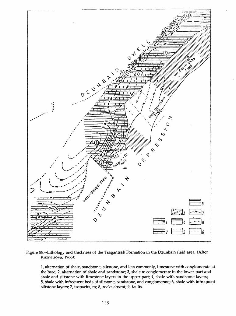
Figure 88. Lithology and thickness of the Tsagantsab Formation in the Dzunbain field area. (After Kuznetsova, 1966):
1, alternation of shale, sandstone, siltstone, and less commonly, limestone with conglomerate at the base; 2, alternation of shale and sandstone; 3, shale to conglomerate in the lower part and shale and siltstone with limestone layers in the upper part; 4, shale with sandstone layers; 5, shale with infrequent beds of siltstone, sandstone, and conglomerate; 6, shale with infrequent siltstone layers; 7, isopachs, m; 8, rocks absent; 9, faults.
135

Figure 89.-Lithology and thickness of the bituminous subformation (paper shale unit) of the Shinhuduk Formation in the Dzunbain field area. (After Kuznetsova, 1966):
1, alternation of siltstone, sandstone, marl, limestone, shale, and bituminous shale; 2, shale (dominant) and sandstone; 3, sandstone (dominant) and shale; 4, shale in the lower part, alternation of shale and sandstone in the upper part; 5, alternation of shale, siltstone, limestone, and sandstone; 6, isopachs, m; 7, rocks absent; 8, faults.
136

Figure 90. Lithology and thickness of the shale-sandstone subformation (above paper shales) of the Shinhuduk Formation in the Dzunbain field area. (After Kuznetsova, 1966):
1, shale with sandstone beds in the middle part of the section; 2, shale with infrequent sandstone and siltstone layers in the lower part and rapid alternation of shale, siltstone, and sandstone in the upper part; 3, shale and marl in the lower part, sandstone with shale layers in the upper part; 4, shale in the lower part, shale and sandstone in the upper part; 5, shale and sandstone with limestone and marl beds at the base; 6, shale with infrequent sandstone and siltstone beds; 7, shale with a few siltstone layers; 8, isopachs, m; 9, faults; 10, rocks absent.
137

Figure 91. Lithology and thickness of the Khukhtyk Formation in the Dzunbain field area. (After Kuznetsova, 1966):
1, alternation of shale, sandstone, and conglomerate; 2, alternation of shale and sandstone with conglomerate at the base; 3, shale and sandstone; 4, shale with infrequent sandstone and siltstone layers; 5, isopachs, m; 6, rocks absent, 7, faults.
138

The Tamtsag basin on the northeast is a continuation of the Hailar basin in northern China. Probably, the general geology of the Tamtsag basin is similar to that of the Southeast Gobi basin; however, no data are available in literature.
PETROLEUM GEOLOGY AND EXPLORATION PLAYS
The Dzunbain field, discovered in the 1940's, is the only field that produced oil in the Southeast Gobi basin. At its peak in 1955, the field produced about 400,000 b/year. In 1963, the production decreased to 140,000 b/year and was terminated soon afterwards. Data on the geology of the field are provided in Marinov and others (1977).
The field is controlled by an anticline about 10 x 4 km in dimensions. The steep (15-20°) limbs of the fold suggest a compressional origin for the structure. The northwestern flank is faulted down 500-600 m relative to the crest of the fold. Several transverse faults with a strike-slip component are present. The fold is mapped on Cretaceous horizons; a syncline underlies the fold at the level of the lower Tsagantsab Formation which is 750-1,200 m thick.
Production in the field is from sandstones of the Shinhuduk and the upper part of the Tsagantsab Formations. The latter contains about 30 pays at depths of 580-850 m and is the main producer. Each pay is from 1 to 11 m thick. Initial flows reached 100-140 b/d but decreased abruptly to a few barrels. The oil is paraffinic, and its gravity is 29-29.5° API. Original oil reserves of the field are about 15 million barrels, but because of low rates of production the field is apparently uneconomic. Porosity of the sandstone reservoirs is 10-24% and the permeability is only 0.2-0.5 md. Fracturing is significant. The low gas-oil ratio (30-40 ftVb) indicates that the field was subjected to degassing.
A few other discoveries in the basin are noncommercial, primarily because of very low oil flows. They include the Tsagan-Els and East Dzunbain fields (figs. 88- 91). Both fields are located on the Bain-Mongol horst and the reservoir properties of oil-saturated rocks there are worse than those in the Dzunbain field. Oil saturation averages only 5-10 % and nowhere exceeds 25-30%. In addition to noncommercial discoveries, several wells on different structures of the basin encountered sandstones saturated with heavy oil and bitumen.
Recent oil discoveries in the Erlian basin have not been described in the literature. Supposedly, they are significant and may amount to several million barrels of oil (H.D. Klemme, personal communication).
Source rocks in both basins are located in the lower part of the clastic section that overlies volcanics of the early rifting stage. In the Southeast Gobi basin, the source rocks are paper shales at the bottom of the Shinhuduk Formation. The source-rock section is 50-100 m thick (fig. 89); paper shales in the section alternate with sandstones and siltstones. Geochemical data are not available; however, the
139

lithological character of the shales and a high content of hydrogen in the organic matter (8.7%) indicate their excellent quality as a source rock. Evidently, the shales were deposited in anoxic deep-lacustrine conditions.
The main source rocks in the Erlian basin are deep-water lacustrine shales in the middle member of the Badalahu Formation. The TOC of the shales averages 2.8%, they contain 0.27% of chloroform extractable bitumen and slightly less than 1000 ppm of hydrocarbons (Fan and others, 1983). The organic matter is of dominantiy sapropelic type. Organic-rich (TOC 1.5%) shales are also present in the middle member of the Bayanhua Formation. However, this organic matter is coaly in character and should be far less important as a source rock.
No data are available on maturation of source rocks in the Southeast Gobi basin. Source rocks seem to be mature at rather shallow depths. Total thickness of the overburden calculated from figures 90 and 91 (plus a few hundred meters of Upper Cretaceous-Tertiary rocks) shows that lower Shinhuduk paper shales are mature at depths of not more than 1,000-1,300 m. A part of the Lower Cretaceous section was removed by pre-Late Cretaceous erosion; thus, maximum temperatures and maturation were most probably achieved by Late Cretaceous time. Basalt eruptions in the Erlian basin and the abundance of volcanic material in rocks of the Southeast Gobi basin suggest high heat flow and resulting shallow maturation depth. In the Erlian basin, the Badalahu Formation source rocks also achieved maturity at depths between 1,000 and 1,500 m (Fan and others, 1983).
Reservoir rocks in both basins are characterized by dirty lithologies due to their arkosic composition, poor sorting, and abundance of volcanic material. Typically, porosity of sandstones is not very low because of the relatively shallow depth of burial and moderate compaction, but permeability is commonly poor.
The main factor which greatly reduces the petroleum potential of the Southeast Gobi basin is poor development of the sag sequence over the grabens. Upper Cretaceous and Tertiary rocks are thin and sandy and apparently have low ability to hydrodynamically seal the highly faulted grabens. Relatively early, pre- Late Cretaceous, time of maturation and following uplift and erosion resulted in partial (Dzunbain and Tsagan-Els fields) or complete destruction of fields. From this point of view, exploration in highly uplifted compressional folds and horsts has little chance for success. Exploration in the basin was conducted by Soviet geologists and/or by Soviet-trained Mongolians and was directed toward targets of this type. Probably this was the reason for the lack of success. Stratigraphic updip pinch-out traps along boundary faults and other subtle types of traps in deeper parts of grabens probably bear significantly more potential. Application of high quality seismics to map deep structure of the grabens is critical; however, modern seismic surveys have never been conducted in Mongolia. Considering the poor quality of reservoir rocks and inadequate sealing of the entire petroleum systems, the petroleum potential of the Southeast Gobi basin is probably low to moderate.
140

The stratigraphic succession and structure of the Tamtsag basin on the northeast of Mongolia (fig. 82) are quite similar to those of the Southeast Gobi basin. Several drill tests (also on highly uplifted structures) did not find significant oil shows; only some inclusions of asphalt were recorded in cores (Marinov and others, 1977). Small oil fields were recently discovered across the border in China, in the Hailar basin (H.D. Klemrne, personal communication). The potential of the basin is probably similar to that of the Southeast Gobi basin.
Conditions for preservation of oil are probably significantly better in the Erlian basin. Although the postrift sag sequence is also poorly developed, thickness of the synrift elastics overlying source rocks of the Badalahu Formation is much larger (to 2.5 km) than this thickness in the Southeast Gobi basin. Thickness of the source-rock section in the Erlian basin is also significantly larger than that in the Mongolian basins. Widespread oil shows observed in the early 1980's are described by Fan and others (1983). Oil-saturated sandstones at shallow (less than 500 m) depths suggest that although sealing is not perfect, pools in deeper horizon have not been completely destroyed. No data on recent discoveries are available, but probably they are in hundreds of million barrels range (H.D. Klemme, personal communication). The available data indicate a significant undiscovered potential for the basin. Imperfect sealing suggests a high probability for dominance of oil in the resources.
141

REFERENCES
Bally, A.W., Chou I-Ming, Clayton, R., and others, 1986, Notes on sedimentary basins in China: U.S. Geological Survey Open-File Report 86-327,108 p.
Chen Binghua, 1985, Structural zones in the Saihantala depression of the Erlianbasin and their relation to oil and gas accumulation: Acta Petrolei Sinica, v. 6, no. 4, p. 41-45.
Chen Changming, Huang Jiakuan, Chen Jingshan, and Tian Xingyou, 1984, Depositional models of Tertiary rift basins, eastern China, and their application to petroleum prediction: Sedimentary Geology, v. 40, p. 73-88.
Chen Fajing, Dai Shizhao, and Pan Guoen, 1989, The Cretaceous-Paleogene salt- bearing basins in eastern China, in Zhu, X., ed., Chinese sedimentary basins: Elsevier, Amsterdam, p. 137-146.
Chen Heli, Jiang Jigang, Luo Xiaorong, and Wang Fengqin, 1988, Compaction of mudstone and oil-gas migration and accumulation conditions of the Xingouzui Formation in the Jianghan basin: Oil and Gas Geology, v. 9, no. 3, p. 268-277.
Chen Quanmao and Dickinson, W.R., 1986, Contrasting nature of petroliferous Mesozoic-Cenozoic basins in eastern and western China: American Association of Petroleum Geologists Bulletin, v. 70, no. 3, p. 263-275.
Chen Zongqing, 1982, The formation of Carboniferous gas pools in east Sichuan: Acta Petrolei Sinica, no. 1, p. 23-28.
Dai Jinxing and Xia Yinghe, 1990, Ordovician gas accumulations in eastern China: Journal of Petroleum Geology, v. 13, no. 1, p. 79-86.
Du Bomin, Xing Shunquan, and Zhou Shuxin, 1984, Characteristics of reservoirsand their diagenetic evolution in the northern part of Songliao basin: Oil and Gas Geology, v. 5, no. 2, p. 122-131.
Fan Shaoyi, Zhang Xiaozhi, Chen Renjiu, and Hu Juwen, 1983, A preliminary study of oil prospects in Xiling depression: Oil and Gas Geology, v, 4, no. 2, p. 192- 201.
Fei Qi and Wang Xiepei, 1984, Significant role of structural fractures in Renqiuburied-hill oil field in eastern China: American Association of Petroleum Geologists Bulletin, v. 68, no. 8, p. 971-982.
142

Guan Shicong, Qiu Dungzhou, Chen Xianqun, Yuan Fungten, Yan Huaiyu, Wang Shoude, Zhou Jingcai, and Chen Sioche, 1981, Geologic history of Late Proterozoic to Triassic in China, in Mason, J.F., edv Petroleum geology in China: Tulsa, Oklahoma, PenWell Publishing Company, p. 142-153.
Guo Zhongming and Zhang Jun, 1989, A discussion on the oil and gas potential of the structural belt on the west margin of the Ordos massif viewed from the thrust nappe tectonics: Acta Petrolei Sinica, v. 10, no. 2, p. 31-38.
Han Dexin and Yang Qi, eds., 1980, Coal geology of China: Beijing, Coal Industry Press, v. 2,415 p.
Hu Chaoyuan, 1985, Geologic characteristics and oil exploration of small depressions in eastern China: Geology, v. 13, no. 4, p. 303-306.
Hu Chaoyuan and Qiao Hanseng, 1983, Characteristics of oil and gas distribution in the North China basin and the adjacent seas: Eleventh World Petroleum Congress, Panel Discussion on Exploration in New Regions, Preprint: London, 9 p.
Hu Jianyi, Liu Shuxuan, Fan Chenglong, Xu Shubao, Zhang Jinquan, and TongXiaogang, 1984, Stratigraphic-lithologic oil and gas pools in continental basins, China: Beijing Petroleum Geology Symposium, Beijing, China, September 1984, Preprint, 27 p.
Hu Jianyi, Fan Chenglong, Zhang Jinquan, Liu Shuxuan, Xu Shubao, and TongXiaogang, 1988, Stratigraphic-lithologic oil and gas pools in continental basins, China, in Wanger, H.C., Wagner, L.C., Wang, F.F.H., and Wong, F.L., eds., Petroleum resources of China and related subjects: Circum-Pacific Council for Energy and Mineral Resources Earth Science Series, v. 10, Houston, Texas, p. 41-62.
Hu Jianyi, Xu Shubao, Tong Xiaoguang, and Wu Huayuan, 1989, The Bohai Baybasin, in Zhu, X., ed., Chinese sedimentary basins: Amsterdam, Elsevier, p. 89- 105.
Huang Difan, Shang Huiyun, and Li Jinchao, 1988, Latest advances in research on nonmarine oil generation in China, in Wagner, H.C., Wagner, L.C., Wang, F.F.H., and Wong, F.L., eds., Petroleum resources of China and related subjects: Circum-Pacific Council for Energy and Mineral Resources Earth Science Series, v. 10, Houston, p. 63-87.
Huang Jiqing, 1980, Some ideas on the oil and gas potential of Sichuan basin and Ordos platform downwarp: Oil and Gas Geology, v. 1, no. 1, p. 18-25.
Huang Jizhong, 1984, On the occurrence of oil and gas in the Yangxin limestone series in Sichuan basin: Acta Petrolei Sinica, v. 5, no. 1, p. 7-18.
143

Ji Xiong and Coney, P.J., 1985, Accreted terranes of China, in Howell, D.G., ed.,Tectonostratigraphic terranes of the Circum-Pacific region: Circum-Pacific Council for Energy and Mineral Resources Earth Science Series, no. 1, Houston, Texas, p. 349-361.
Jiang Jigang and Zhang Qian, 1982, The generation and evolution of petroleum in the saline Qianjiang Formation in the Jianghan basin: Oil and Gas Geology, v. 3, no. 1, p. 1-15.
Johnson, M.E., Rong Jia-Yu, and Yang Xue-Chang, 1985, Intercontinental correlation by sea-level events in the Early Silurian of North America and China (Yangtze platform): Geological Society of America Bulletin, v. 96, no. 11, p. 1384-1397.
Khasin, R.A., Borzakovsky, Yu. A., and Zonenshayn, L.P., 1973, Geology of the People's Republic of Mongolia (Geologiya Mongolskoy Narodnoy Respubliki), v. 2, Magmatism, metamorphism, and tectonics: Nedra, Moscow, 836 p.
Kuznetsova, M.M., 1966, New data on Lower Cretaceous rocks of the Dzun-Bain area in eastern Gobi, in Marinov, N.A., ed., Data on the geology of the People's Republic of Mongolia (Materialy po geologii Mongolskoy Narodnoy Respubliki): Nedra, Moscow, p. 65-73.
Lee, K.Y., 1986, Geology of the Mesozoic coal and petroleum deposits in the Ordos basin, China: U.S. Geological Survey Open-File Report 86-278, 63 p.
Lee, K.Y., 1989, Geology of petroleum and coal deposits in the North China basin, eastern China: U.S. Geological Survey Bulletin 1871, 36 p.
Lee, K.Y. and Masters, CD., 1988, Geologic framework, petroleum potential, andfield locations of the sedimentary basins in China: Map 1-1952, Miscellaneous Investigations Series, U.S. Geological Survey
Li Chunju, Zhu Shuian, and Zhu Shaobi, 1988, Sedimentary analysis and oil-bearing structures of the Biyang basin, southern Henan Province, China, in Wagner, H.C., Wagner, L.C., Wang, F.F.H., and Wong, F.L., eds., Petroleum resources of China and related subjects: Circum-Pacific Council for Energy and Mineral Resources Earth Science Series, v. 10, Houston, Texas, p. 297-310.
Li Desheng, 1983a, Tectonic types of oil and gas basins in China: Scientific Research Institute of Petroleum Exploration and Development: Beijing, China, Preprint, 21 p.
Li Desheng, 1983b, Geological structure and hydrocarbon occurrence of the Bohai Gulf oil and gas basin, in Petroleum Geology of China, Petroleum Industry Press, p. 180-192.
144

Li Desheng, Du Yonglin, and Hu Guonong, 1988, Petroleum geology of theLangfang-Guan basin, Beijing-Tienjing region, China, in Wagner, H.C., Wagner, L.C., Wang, F.F.H., and Wong, F.L., eds., Petroleum resources of China and related subjects: Circum-Pacific Council for Energy and Mineral Resources Earth Science Series, v. 10, Houston, Texas, p. 219-234.
Li Desheng, 1990, Recent acvances in the petroleum geology of China: Journal of Petroleum Geology, v. 13, no. 1, p. 7-18.
Li Xuehui and Li Tiesheng, 1988, Favorable oil- and gas-bearing fades of the Carboniferous and Permian Systems in South China in Wagner, H.C., Wagner, L.C., Wang, F.F.H., and Wong, F.L., eds., Petroleum resources of China and related subjects: Circum-Pacific Council for Energy and Mineral Resources Earth Science Series, v. 10, Houston, Texas, p. 121-134.
Liu Hefu, 1986, Geodynamic scenario and structural styles of Mesozoic and Cenozoic basins in China: American Association of Petroleum Geologists Bulletin, v. 70, no. 4, p. 377-395.
Liu Hungyun, Sha Chingan, and Hu Shinling, 1973, The Sinian System in southern China: Scientia Sinica, v. 16, no. 2, p. 266-278.
Lu Xichu, 1982, Review and discussion on discoveries in the Jianghan petroleum province: Oil and Gas Geology, v. 3, no. 2, p. 170-176.
Ma Li, 1985, Subtle oil pools in Xingshugang delta, Songliao basin: American Association of Petroleum Geologists Bulletin, v. 69, no. 7, p. 1123-1132.
Ma Li, Ge Taisheng, Zhao Xueping, Zie Taijun, Ge Rong, and Dang Zhenrong, 1982, Oil basins and subtle traps in the eastern part of China, in Halbouty, M.T., ed., The deliberate search for the subtle traps: American Association of Petroleum Geologists Memoir 32, p. 287-315.
Ma Li, Yang Jiliang, Ding Zhengyan, and Guan Zengmiao, 1988, Petroleum potential of part of the Quantou Formation, Songliao basin, northeast China, in Wagner, H.C., Wagner, L.C., Wang, F.F.H., and Wong, F.L., eds., Petroleum resources of China and related subjects, Circum-Pacific Council for Energy and Mineral Resources Earth Science Series, v. 10, Houston, Texas, p. 235-250.
Ma Li, Yang Jiliang, and Ding Zhengyan, 1989, Songliao basin an intracratoniccontinental sedimentary basin of combination type, in Zhu, X., ed., Chinese sedimentary basins: Amsterdam, Elsevier, p. 77-87.
Marinov, N.A., Khasin, R.A., and Khurts, Chv eds., 1977, Geology of the People's Republic of Mongolia (Geologiya Mongolskoy Naradnoy Respubliki), v. 3, Mineral resources: Nedra, Moscow, 283 p.
145
Martinson, G.G., ecL, 1982, Mesozoic lake basins of Mongolia (Mezozoyskiye ozernye basseyny Mongolii): Nauka, Leningrad, USSR, 210 p.
Masters, C.D., Root, D.H., and Attanasi, E.D., 1990, World oil and gas resources- Future production realities: Annual Review of Energy, v. 15, p. 23-51.
Matsuzawa, Arika, 1988, Oil and gas exploration in Bohai Bay, China, in Wagner, H.C., Wagner, L.C., Wang, F.F.H., and Wong, F.L., eds., Petroleum resources of China and related subjects: Circum-Pacific Council for Energy and Mineral Resources Earth Science Series, v. 10, Houston, Texas, p. 263-275.
Meyerhoff, A.A., 1982, Petroleum basins of the Union of Socialist Soviet Republics and the People's Republic of China and the politics of petroleum: Petroleum Exploration Society of Australia, Distinguished Lecture Series, 341 p.
Nagibina, M.S., 1970, Types of Mesozoic and Cenozoic structures in Mongolia and the trend of their development: Geotectonics, no. 5, p. 295-299.
Nagibina, M.S., Shuvalov, V.F., and Martinson, G.G., 1977, Main features of stratigraphy and history of development of the Mesozoic structures of Mongolia, in Zaytsev, N.S., and Yanshin, A.L., eds., Main problems of the geology of Mongolia (Oshovnye problemy geologii Mongolii): Soviet- Mongolian Geologic Expedition, Proceedings, v. 22, Nauka, Moscow, p. 76-90.
Oil and Gas Journal, 1984, International briefs, November 12, p. 78.
Oil and Gas Journal, 1985, International briefs, January 28, p. 84.
Scott, R.W., 1990, 138 rigs are operating in 59-field Shengli area: World Oil, v. 211, no. 2, March 1990, p. 69-75.
Shaui Defu, Qian Kai, Song Yongshen, and Ge Rong, 1988, Stratigraphic-
lithologic oil and gas pools in the Jiyang depression, China, in Wagner, H.C., Wagner, L.C., Wang, F.F.H., and Wong, F.L., eds., Petroleum resources of China and related subjects: Circum-Pacific Council for Energy and Mineral Resources Earth Science Series, v. 10, Houston, Texas, p. 329-344.
Shuvalov, V.F., 1969, Upper Jurassic continental red beds of Mongolia: Doklady Akademii Nauk USSR, v. 189, no. 5, p. 1088-1091.
Song Guochu, 1984, Geologic conditions of paleolandforms oil-field formation in Jurassic System for Shan-Gan-Ning basin: Beijing Petroleum Geology Symposium, September 1984, Beijing, China, Preprint, 22 p.
Sun Guofan and Liu Jingping, 1983, Helan aulacogen and front basin and their evolution: Oil and Gas Geology, v. 4, no. 3, p. 236-245.
146

Sun Guofan, Liu Jingping, and Miao Yongwang, 1983, Preliminary study onpetroleum potential of the upper Paleozoic in the northern Ordos basin: Oil and Gas Geology, v. 4, no. 1., p. 110-115.
Sun Shu, Li Jilang, Chen Haihong, Peng Haipo, Hsu, K.J., and Shelton, J.W., 1989, Mesozoic and Cenozoic sedimentary history of South China: American Association of Petroleum Geologists Bulletin, v. 73, no. 10, p. 1247-1269.
Sun Zhaocai, Xie Qiuyuan, and Yang Junjie, 1989, Ordos basin a typical example of an unstable cratonic interior superimposed basin, in Zhu, X., ed., Chinese sedimentary basins: Amsterdam, Elsevier, p. 63-75.
Tang Xiyuan, Guo Zhongming, and Wang Dingyi, 1988, The characteristics andevolution of the thrust nappe tectonic belt and its petroleum potential in the western Ordos basin: Oil and Gas Geology, v. 9, no. 1., p. 1-10.
Tang Zeyao and Zhan Shenyu, 1988, Origin of Sinian (Upper Proterozoic) gas pools in the Sichuan basin, China, in Wagner, H.C., Wagner, L.C., Wang, F.F.H., and Wong, F.L., eds., Petroleum resources of China and related subjects: Circum-Pacific Council for Energy and Mineral Resources Earth Science Series, v. 10, Houston, Texas, p. 359-370.
Tian Zaiyi, Chang Chengyong, Huang Difan, and Wu Chongyun, 1983, Sedimentary fades, oil generation in Mesozoic-Cenozoic continental basins in China: Oil and Gas Journal, May 16,1983, p. 120-126.
Ulmishek, Gregory, 1984, Geology and petroleum resources of basins in western China: Argonne National Laboratory Report ANL/ES-146,130 p.
U.S. Energy Information Administration, 1987, The petroleum resources of China, DOE/EIA-0501,90p.
Wang Jinqi, Bao Ci, Lou Zhili, and Guo Zhengwu, 1989, Formation anddevelopment of the Sichuan basin, in Zhu, X., ed., Chinese sedimentary basins: Elsevier, Amsterdam, p. 147-163.
Wang Shangwen, Zhang Wanxuan, Zhang Houfu, and Tan Shidian, 1983, Sichuan basin, in Petroleum geology of China: Petroleum Industry Press, Beijing, p. 285-293.
Wang Shaochang and Liu Yujin, 1983, Analysis of the geologic conditions offormation of natural gas related to coal forming in the upper Paleozoic of the Shan-Gan-Ning basin: Petroleum Exploration and Development, no. 1., p. 13- 23.
Wang Tzun-Cheng, 1969, Weiho graben: International Geology Review, v. 11, no. 2, p. 209-217.
147

Wang Xiepei, Fei Qi, and Zhang Jiahua, 1985, Cenozoic diapiric traps in easternChina: American Association of Petroleum Geologists Bulletin, v. 69, no. 12, p. 2098-2109.
Watson, M.P., Hayward, A.B., Parkinson, D.N., and Zhang, Zh. M., 1987, Platetectonic history, basin development and petroleum source rock deposition onshore China: Marine and Petroleum Geology, v. 4, p. 205-225.
Wu Huayuan and Liang Digang, 1988, Formation conditions of three oil fields in the Jizhong depression, China, in Wagner, H.C., Wagner, L.C., Wang, F.F.H., and Wong, F.L., eds., Petroleum resources of China and related subjects: Circum- Pacific Council for Energy and Mineral Resources Earth Science Series, v. 10, Houston, Texas, p. 311-328.
Xie Taijun, Wu Lizhen, and Jiang Jigang, 1988, Oil and gas fields in the Jianghan basin, Hubei Province, China, in Wagner, H.C., Wagner, L.C., Wang, F.F.H., and Wong, F.L., eds., Petroleum resources of China and related subjects: Circum-Pacific Council for Energy and Mineral Resources Earth Science Series, v. 10, Houston, Texas, p. 345-358.
Xu Shice and Wang Hengjian, 1983, Deltaic deposits of a large lake basin, inPetroleum geology of China: Petroleum Industry Press, Beijing, p. 202-213.
Xu Yongchang, Shen Ping, and Wang Xianbin, 1984, Isotopic geology of petroleumand natural gas in China: Beijing Petroleum Geology Symposium, September 1984, Preprint, Beijing, China, 15 p.
Van Dunshi and Zhai Guangming, 1981, Exploration practice in and prospects of the buried-hill oil fields in north China, in Petroleum geology of China: Petroleum Industry Press, Beijing, p. 92-100.
Yang Jiliang, 1983, Characteristics of oil pools in Daqing oil field and theaccumulation regularities of oil and gas in Songliao basin: Oil and Gas Geology, v. 4, no. 2, p. 171-180.
Yang Wanli, 1985, Daqing oil field, People's Republic of China: a giant field with oil of nonmarine origin: American Association of Petroleum Geologists Bulletin, v. 69, no. 7, p. 1101-1111.
Yang Wanli, Li Yongkang, and Gao Ruiqi, 1985, Formation and evolution ofnonmarine petroleum in Songliao basin, China: American Association of Petroleum Geologists Bulletin, v. 69, no. 7, p. 1112-1122
Yin Jiantang, 1985, Sichuan basin, in ESCAP atlas of stratigraphy IV, People'sRepublic of China, Economic and Social Commission for Asia and the Pacific Mineral Resources Development Series, no. 52, United Nations, New York, p. 63-69.
148

Yuan Bungcun, Chen Rongshu, Wan Jingping, Cai Xifen, Liu Anlin, and ZhaiChaiyu, 1983, Early Eocene sedimentary environment of Jianghan basin and its oil and gas potential: Oil and Gas Geology, v. 4, no. 4, p. 393-402.
Zha Quanheng, 1984, Jizhong depression, China its geologic framework, evolutionary history, and distribution of hydrocarbons: American Association of Petroleum Geologists Bulletin, v. 68, no. 8, p. 983-992.
Zhai Guangming and Zha Quanheng, 1982, Buried-hill oil and gas pools in theNorth China basin, in Halbouty, M.T., ed., The deliberate search for the subtle traps: American Association of Petroleum Geologists Memoir 32, p. 317-335.
Zhai Guangming, Wang Shenyan, and Li Gansheng, 1988, Characteristics and oil and gas potential of sedimentary basins of China, in Wagner, H.C, Wagner, L.C., Wang, F.F.H., and Wong, F.L., eds., Petroleum resources of China and related subjects: Circum-Pacific Council for Energy and Mineral Resources Earth Science Series, v. 10, Houston, Texas, p. 1-22.
Zhang Jinshan, 1982, Tectonic evolution of the Ordos basin and its oil and gas potential: Oil and Gas Geology, v. 3, no. 4, p. 304-315.
Zhang Jiazhen, 1985, Huabei-Bohaiwan basin, in ESCAP atlas of stratigraphy IV, People's Republic of China, Economic and Social Commission for Asia and the Pacific, Mineral Resources Development Series no. 52, United Nations, New York, p. 22-27.
Zhang Jisen, Fei Anqi, and Wang Zhihui, 1982, Paleogeographic features of Middle Ordovician sediments on Ordos continental shelf: Oil and Gas Geology, v. 3., no. 4, p. 360-368.
Zhang Wenyou and Zhang Kang, 1988, Mesozoic and Cenozoic basins andhydrocarbon prospects in China and adjacent offshore area, in Wagner, H.C., Wagner, L.C., Wang, F.F.H., and Wong, F.L., eds., Petroleum resources of China and related subjects: Circum-Pacific Council for Energy and Mineral Resources Earth Science Series, v. 10, Houston, Texas, p. 89-100.
Zhang Wenyou, Zhang Kang, Zhao Yonggui, Cai Xinping, Wang Xinhe, Xu Guizhong, Wu Haiwei, Han Beichuan, and Zeng Xiangshan, 1983, The Mesozoic and Cenozoic geotectonic characteristics and dynamic model of the lithosphere in North China fault block region: Acta Geologica Sinica, v. 57, no. 1, p. 33-42.
Zhao Xueping, Zhang Fumin, and Yang Huairan, 1988, Seismic reflection studies in the Huanghua depression, Bohai Bay basin, China, in Wagner, H.C., Wagner, L.C., Wang, F.F.H., and Wong, F.L., eds., Petroleum resources of China and related subjects: Circum-Pacific Council for Energy and Mineral Resources Earth Science Series, v. 10, Houston, Texas, p. 277-296.
149

Zheng Changming, 1988, A new exploration method for buried-hill oil fields, the Liaohe depression, China, in Wagner, H.C., Wagner, L.C., Wang, F.F.H., and Wong, F.L., eds., Petroleum resources of China and related subjects: Circum- Pacific Council for Energy and Mineral Resources Earth Science Series, v. 10, Houston, Texas, p. 251-262.
Zheng Zuyan, 1980, The compounding patterns of early and late Neocathasian tectonic units in the eastern Sichuan province and their control on the Permian and Triassic gas deposits: Oil and Gas Geology, v. 1, no. 2, p. 126-136.
Zhou Xingxi, Yuan Rong, Li Xuexin, Liu Wenli, and Ran Weili, 1988, Estimation of coal-generated gas using the geologic-thermal-evolution-sifting method in the North China basin, in Wagner, H.C., Wagner, L.C., Wang, F.F.H., and Wong, F.L., eds., Petroleum resources of China and related subjects: Circum- Pacific Council for Energy and Mineral Resources Earth Science Series, v. 10, Houston, Texas, p. 577-585.
Zhou Zhennan, Qiu Songyu, and Huang Changnian, 1985 Songliao basin, in ESCAP atlas of Stratigraphy IV, People's Republic of China, Economic and Social Commission for Asia and the Pacific, Mineral Resources Development Series no. 52, United Nations, New York, p. 13-21.
Zhu Jiawei and Xu Huazheng, 1988, Geochemical characteristics of natural gas in the Dongpu depression, North China, in Wagner, H.C., Wagner, L.C., Wang, F.F.H., and Wong, F.L., eds., Petroleum resources of China and related subjects: Circum-Pacific Council for Energy and Mineral Resources Earth Science Series, v. 10, Houston, Texas, p. 535-545.
Zhu Shuian, Xu Shirong, Zhu Shaobi, and Wang Yixian, 1981, Petroleum geological characteristics of the Biyang depression, Henan: Acta Petrolei Sinica, v. 2, no. 2, p. 21-28.
Zhu Zongqi, Lee Biqi, and Xie Qiuyuan, 1981, Maturity of organic matter and oil and gas potential of the Taiyuan Formation in the northern Ordos basin according to the vitrinite reflectivity: Oil and Gas Geology, v. 2, no. 3, p. 284-291.
150