united states agriculture forest service private
TRANSCRIPT

PRIVATE ENTERPRISE AND EARLY TWENTIETH
'CENTURY WATER RESOURCE DEVELOPMENT
ON OREGON'S SECOND LARGEST LAKE
A CULTURAL RESOURCE EVALUATION REPORT OF THE
KLOVDAHL TUNNEL AND HEADGATE STRUCTURE
WALDO LAKE, WILLAMETTE NATIONAL FOREST, OREGON
PAUL G. CLAEYSSENS
United StatesDepartment ofAgriculture
Forest Service
PacificNorthwestRegion
WillametteNational Forsst

PRIVATE ENTERPRISE AND EARLY TWENTIETH CENTURY
WATER RESOURCE DEVELOPMENT ON OREGON'S SECOND LARGEST LAKE
A CULTURAL RESOURCE EVALUATION REPORT OF THE
KLOVDAHL TUNNEL AND HEADGATE STRUCTURE
WALDO LAKE, WILLAMETTE NATIONAL FOREST, OREGON
Submitted by
Paul G. Claeyssens
Cultural Resource Specialist
Oakridge Ranger District
Willamette National Forest
Eugene, Oregon
May 1987
Carl M. Davis, Willamette National Forest, P0 Box 1060], Eugene9 OR 97440
OR.
a bNone
m
ci
(?P'-Y Ca&i £SAcC byOREStLSERVJCE
CONCUR
xxx
DO NOT CONCUR
structure as a 'hydro-engineering anomaly',and fact that construiicn was 'majorengineering ac}ylevern4nt of phe tine" would
lend credibi1iy/ to/a deterftinafion ofeligibility ur@drtbiteriio4 "C" also.
il'
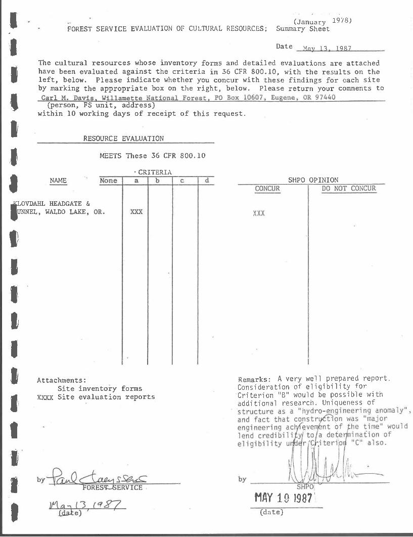
(January 1978)FOREST SERVICE EVALUATION OF CULTURAL RESOURCES; Summary Sheet
Date Mi 1 1Q$7
The cultural resources whose inventory forms and detailed evaluations are attachedhave been evaluated against the criteria in 36 CFR 800.10, with the results on theleft, below. Please indicate whether you concur with these findings for each siteby marking the appropriate box on the right, below. Please return your comments to
(person, FS unit, address)within 10 working days of receipt of this request.
RESOURCE EVALUATION
MEETS These 36 CFR 800.10
CRITERIANAME SHPO OPINION
OVDAHL HEADGATE &UNNEL, WALDO LAKE,
Remarks: A very well prepared report.Consideration of eligibility forCriterion "B' would be possible withadditional research. Uniqueness of
F1Y 19 1987(date)
II Attachments:
Site inventory forms
I Xxxx Site evaluation reports
IIII

S
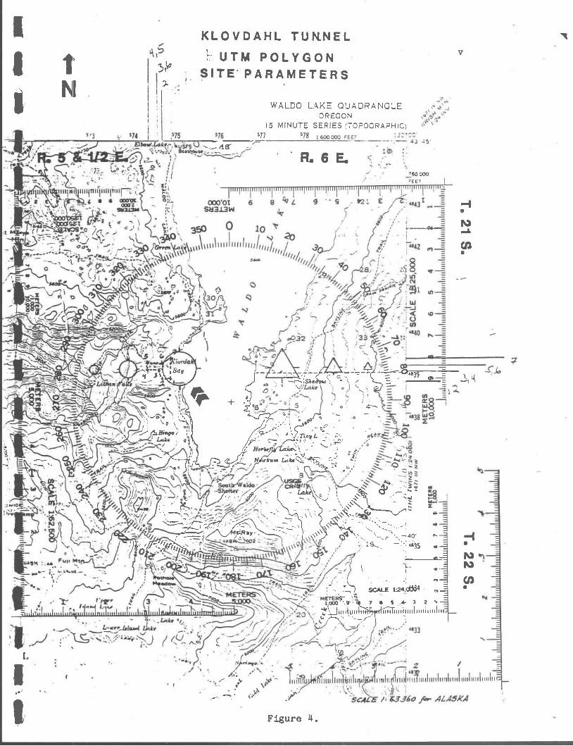
LEGAL DESCRIPTION
County Lane
Township 21 South
Range 5 and 1/2 East
Section 36
USGS Quad. Waldo Lake 15 Minute, 1956
UTM Zone 10
UTM Polygon Coordinates (See Figure 11)
Eastin&
Cover photograph is of the Klovdahl Headgate as seen from Waldo Lake, takenby an unknown photographer during an official Forest Service visit in 1939.
1. 575025 11838750
2. 5711800 11838750
3. 5711700 11839000
11. 5711500 11839000
5, 5711500 11839150
6. 5711700 11839150
7. 575025 11839300

'4
N4.
PORTLAND
SALEM
EUGENE
Forest Service U.S.D.A.Pacific Northwest RegionWillamette National Forest
STATE OF OREGON
WALDO LAKE
/
iflOS 1S3*4O4 1vNOLLYN
BJ.flod ;x'VLS
'I' N
/
I OAKRIDGERANGER DISTRICTI WILLAMETTE NATIONAL FOREST
$ VICINITY: MAP
2
L
$
IIII
II
I
-
0'
RANGER DISTRICT BOUNDARY
RANGER STATION
Folk
Mt SRay.t'Fuj1,) IMD, ,.
Figure 2.
I )c:KLOVDAHL TUN
t AND HEADGATE$
I1
iii
I r,p
a

II
*
.5&1/2E.Sr
25'k
300 t%Q
0
lovdahlBay
;i------Io w.
4NE
\ HnoaoaeflarOfl stan
31
01
0
tN
)i/Shadowy\T c
iv
Howcum Iake
iHrj 8I / Betty
R.6ES
-\r -SCALE - 4 1a'tiIC__
II
a-' vo1
a
r -
IBinq'oLake
I
'Jo
00
o Campgroundo II USDA FOREST SERVI
A
"i. & I \ TRI COMPARMENT AP
- - I
Shadow BaysCam pg rou
Bay-'(O)U t
Oe
0
'0Horsfly La/tL\
I \O
pnao?Lake
0 fI,J
i,,T'tnyL (R
-
" 12 cot ITW WAI flO / ,1
Figure 3. Waldo Lakes southern segment.
' icnI
£TboWL.gk' L.)
BO1L=z::_2. ; 0
I
OOOOt 6 8 L -- S *21- SL3Id
Lç'c : 0 i- i. ,-
/Ill'
- ; - /?.' i' A ;T''' "1-49'
= : 0_1
33j;s''_ $Hc-H I' \_ A
:,oC f
r M-ZjO2
Lrja1 L.ikeij
.-; a
1
c-4'38
M
/ 23
T1 '
5C4L
4j45
2 /1, II ii 1 itt flI pp pIIpIii
/ &'J6o ft.- ALA5XA
-
'SI
7875 76 6OQOOO 'EET
Th -
J
S
KLOVDAHL TUNNELUTM POLYGON
SITE PARAMETERS
577
T,18- j
WALDO LAKE QUADRANGLEOREGON
15 MINUTE SERIES (TOPOGRAPHIC)
4639- ___
R.6E.
Figure
o 4'-'
TinyL
(' Horie3yL1Ik.e¼. S
d-u,N
760 000FEET
a-
---
SCALE 124.4
7 6 6.- 2 %-
S
M1.
Cl)S
MANAGEMENT SUMMARY
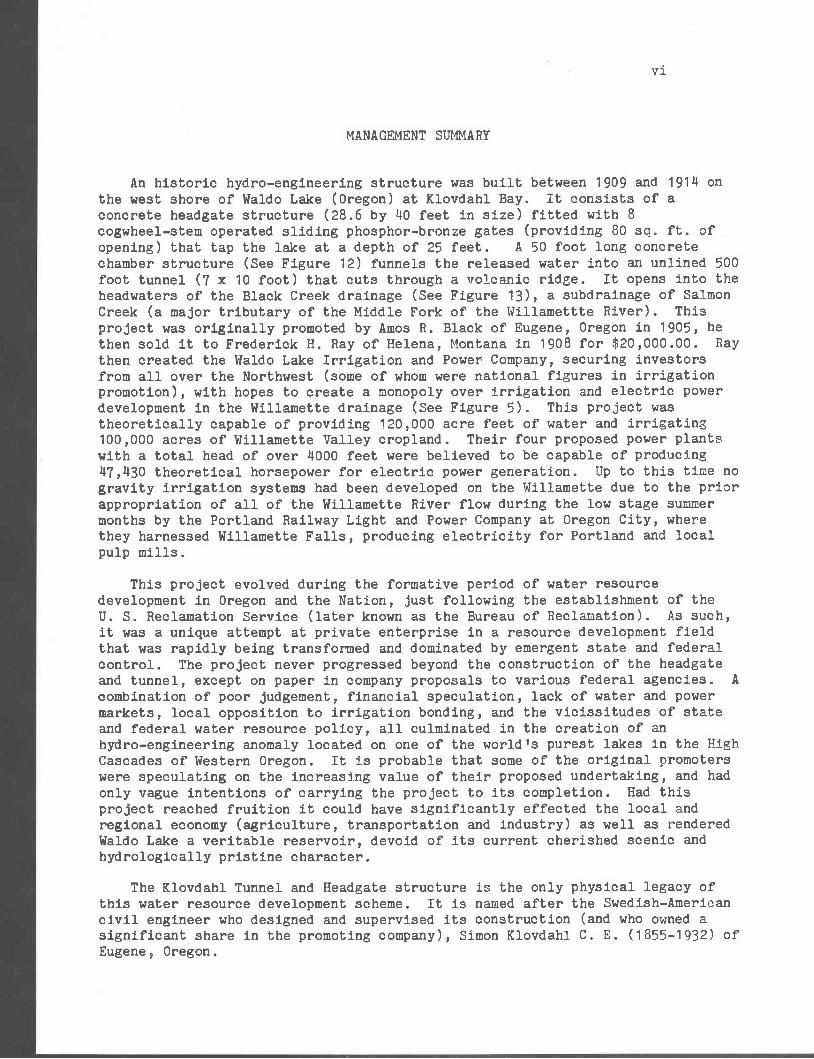
An historic hydro-.engineering structure was built between 1909 and 191k onthe west shore of Waldo Lake (Oregon) at Klovdahl Bay. It consists of aconcrete headgate structure (28.6 by 140 feet in size) fitted with 8cogwheel-stem operated sliding phosphor-bronze gates (providing 80 sq. ft. ofopening) that tap the lake at a depth of 25 feet. A 50 foot long concretechamber structure (See Figure 12) funnels the released water into an unlined 500foot tunnel (7 x 10 foot) that cuts through a volcanic ridge. It opens into theheadwaters of the Black Creek drainage (See Figure 13), a subdrainage of SalmonCreek (a major tributary of the Middle Fork of the Willamettte River). This
project was originally promoted by Amos H. Black of Eugene, Oregon in 1905, hethen sold it to Frederick H. Ray of Helena, Montana in 1908 for $20,000.00. Raythen created the Waldo Lake Irrigation and Power Company, securing investorsfrom all over the Northwest (some of whom were national figures in irrigationpromotion), with hopes to create a monopoly over irrigation and electric powerdevelopment in the Willamette drainage (See Figure 5). This project wastheoretically capable of providing 120,000 acre feet of water and irrigating100,000 acres of Willamette Valley cropland. Their four proposed power plantswith a total head of over k000 feet were believed to be capable of producingk7,130 theoretical horsepower for electric power generation. Up to this time nogravity irrigation systems had been developed on the Willamette due to the priorappropriation of all of the Willamette River flow during the low stage summermonths by the Portland Railway Light and Power Company at Oregon City, wherethey harnessed Willamette Falls, producing electricity for Portland and localpulp mills.
This project evolved during the formative period of water resourcedevelopment in Oregon and the Nation, just following the establishment of theU. S. Reclamation Service (later known as the Bureau of Reclamation). As such,
it was a unique attempt at private enterprise in a resource development fieldthat was rapidly being transformed and dominated by emergent state and federalcontrol. The project never progressed beyond the construction of the headgateand tunnel, except on paper in company proposals to various federal agencies. A
combination of poor judgement, financial speculation, lack of water and powermarkets, local opposition to irrigation bonding, and the vicissitudes of stateand federal water resource policy, all culminated in the creation of anhydro-engineering anomaly located on one of the world's purest lakes in the HighCascades of Western Oregon. It is probable that some of the original promoterswere speculating on the increasing value of their proposed undertaking, and hadonly vague intentions of carrying the project to its completion. Had thisproject reached fruition it could have significantly effected the local andregional economy (agriculture, transportation and industry) as well as renderedWaldo Lake a veritable reservoir, devoid of its current cherished scenic andhydrologically pristine character.
The Klovdahl Tunnel and Headgate structure is the only physical legacy ofthis water resource development scheme. It is named after the Swedish-Americancivil engineer who designed and supervised its construction (and who owned asignificant share in the promoting company), Simon Klovdahl C. E. (1855-1932) ofEugene, Oregon.
vi

MANAGEMENT SUMMARY (continued)
This structure is herein evaluated for its eligibility to the NationalRegister of Historic Places. Following the criteria of significance ascontained in 36 CFR 60 and elaborated in How to Apply the National Re&isterCriteria for Evaluation (National Park Service 1982 [Draft]) this documentaddresses the following prerequisites; integrity, historic context, level ofsignificance and specific criteria considerations. The Klovdahl Tunnel andHeadgate, sometimes referred to as the 'Klovdahl Dam', is determined to beeligible to the National Register of Historic Places. The rationale upon whichthis judgement was reached is presented in the accompanying report.
By way of summary this engineering structure is determined to be eligible tothe National Register for the following reasons:
The Klovdahl Tunnel and Headgate historic structure possesses integrity bothin its retention of original design, materials, engineering, character andlocation. Despite leakage occurring around the gates and portions of theheadgate structure, it is basically sound and will remain so for many yearsto come.
The historic context within which this hydro-engineering structure isevaluated, is the Reclamation Period of the Western United States. Thisperiod corresponds generally to the era after 189L within which the stateand federal governments took an active role in the promotion and developmentof' water resource projects. Reclamation was promoted to facilitate thegrowth of regional agricultural economies through irrigation and to supplythe power needs of nascent industrial and natural resource based economies.
The Klovdahl hydro-engineering structure is an extant representative of theinitial period of water resources development in the Western Cascades ofOregon. The structure and its related reclamation project was promoted byprivate interests during the time in which state and federal management ofwater resources was in its formative stage. This cultural resource is thusdetermined to be significant at the local level: It illustrates thecontentious relationship between private interest and national policy withregard to the management of water resources and their reclamation during theearly years of the twentieth century.
vii

4
NOYE$
J4i/do L (Ike I/(5(TYO/1
4
p.. o
WALDO LAKE IS 28 .iIn. diunni ko Mood. .1 No.d. Fo.I
70 rn.lon d..inou hon. Eonnn
84 .ndn. d..ion hon. jnouo..
88 n..Io. dni..ni hon. )1o,n.Lo.
114 n.lo. d...o4 horn Albony
.Aiap 3hoPviflj-aa.1 cl,iu,',e6 of sfrpa,ns (o co,,.tysfo,Yv$'c walcr (/ cflvuii ihoI/u twroim,ie a,ea' of lJpr )Vdlrii,,eI/v°J'tlley llrId heal tia,, 6e I1JYJaI(e'l/hb)e 11wriver. hJivcØk k.,v lepel v'e(i,a/s /
3ü.. ,7d,oA1. I
Einoot.o. .1 WoIdo LoI 5437 boni
Mouth ol N0,.h F.nL 10(0 Fni
Eo.on 433 Font
Junction 332 Font
H.oi,l,o, 32% Font
Athony 22.3 Font
PREFACE AND ACKNOWLEDGEMENTS
This determination of eligibility to the National Register of HistoricPlaces for the Klovdabl Tunnel and Headgate structure was initiated to complywith 36 CFR 800 and related federal resource laws and in response to theproposed repair to the structure. The Willamette National Forest is currentlyplanning to effect a long-term solution to a water leakage problem through theheadgate. This leakage, currently estimated at 300 gallons per minute (gpm),has plagued this structure since shortly after its original construction.During the late 1920's and again during the late 1950's leakage wassignificantly higher than at present, reaching 5,500 gpm in 1957. Two repairshave been previously executed, both of which relied on the replacement orapplication of additional concrete to the headgates to seal the leaks; oneperformed in 1929 by the Waldo Lake Irrigation and Power Company, and the nextin 1960 by the USDA Forest Serivce, Willamette National Forest. During theearly 1980's Wi].lamette National Forest engineers were directed to begininspections of the structure due to public concerns over increased leakage oflake water. Some patchwork was performed with hydraulic cement in 19814, andextensive analysis and planning for an eventual permanent repair was initiated.
Currently an environmental analysis in being conducted under the leadershipof David Murdough, Oakridge Ranger District watershed specialist, to select analternative that will effect a permanent water-tight seal of the tunnel. The EAprocess has identified the major concerns as; the prevention of an uncontrolledrelease of water from the lake through leaks in the headgate structure, loweringof the lake level as much as 25 feet thus severely effecting the lacustrineecosystem and scouring the Black Creek drainage, and protecting the historicresource values of this early twentieth century hydro-engineering structure.Dave Nordenson, Willamette National Forest Structural Engineer, is theengineering team leader and the author, Paul Claeyssens, is assigned to the taskof cultural resource assessment.
As in any such effort so many people and organizations contributed to thedevelopment of this document. The author wishes to extend his sincere gratitudeto the following persons for providing assistance, often on short order, so manyof whom showed such great enthusiasm for this site's history: Dave Nordenson,Willamette National Forest; Marty West, Lane County Historical Museum; F. GailThroop, USDA FS Pacific Northwest Region; Elizabeth W. Potter, State HistoricPreservation Office, Margaret Hollis, Willamette National Forest; GeraldWilliams, Umpqua and Willamette National Forests; Stephen D. Beckham, Lewis andClark College; Bob Cox, Lane County Historical Society; Tom McCallister, TheOregonian; Lewis L. MoArthur, Oregon Geographic Name Board and the OregonHistorical Society; Carl Davis and Jim Cox, Willamette National Forest; DougWilliamson, Willamette National Forest; Staffs of the University of OregonLibrary 'Oregon Collection', Montana State Historical Museum Library, MontanaSecretary of State Corporations Bureau, Eastern Washington State Museum Libraryand to others I have unknowingly omitted. The author also wishes to thank allmy co-workers and especially my family for their patience and support duringthis endeavor. As with the usual caveat, the author excepts fullresponsibility for the final product, including any potential errors foundherein.
P. C.
May 1987
ix

'C
TABLE OF CONTENTS
MANAGEMENT SUMMARY .........,........ ,......................... .vi
PREFACE AND ACKNOWLEDGEMENTS
TABLE OF CONTENTS................................0
...............x
LIST OF FIGURES xi
INTRODUCTION 1
ENVIRONMENTAL SETTING 3
HISTORIC CONTEXT ............................... ...........
HISTORIC SUMMARY.............. ..............7
ANALYSIS OF SIGNIFICANCE...............................17
Integrity of Structure ..................... . . ......... 17
Reclamation Theme 17
Association with Persons 18
CONCLUSION. 19
REFERENCES 20

LIST OF FIGURES
xi
Map of the State of Oregon. ...................... ...............ii.
Oakridge Ranger District area vicinity map. ....., ...............iii
Map of Waldo Lake, southern segment iv
14 USGS Waldo Lake 15 Minute Quadrangle map, 1956 v
Klovdahl's 1909 "Waldo Lake Reservoir" project map viii
Current view (west) of the Klovdahl Headgate, 1986 2
Current view (southwest) of the Klovdahl Headgate, 1986 2
Aerial view of Waldo Lake from the south, 1971 12
View of "Black Cut" at North Waldo outlet in 1913 12
Klovdahl Headgate and construction workers in 1913 13
Klovdahl Headgate, view from the cofferdam (west), 1913
Plan view of Headgate Chamber and Tunnel 15
Profile of Klovdahl Headgate/Tunnel System and ridge 16
INTRODUCTION
Picture back at the turn of the century a group of entrepreneurs eager tocapitalize on what was then perceived as a sound investment, returning 300%profit (Klovdahl N. D.), controlling a monopoly over the services rendered, andyou will begin to have a feeling for the enthusiam and faith these men had intransforming a great wilderness lake into a reservoir capable of irrigating100,000 acres of Willaniette Valley cropland and providing between 30,000 to50,000 horsepower of electrical generation, "without a_a" (Ibid, emphasisoriginal). This enterprise, first pursued in 1905 by A. R. Black of LaneCounty and later in 1908 by F. H. Ray and the Waldo Lake Irrigation and PowerCompany, became known as the Klovdahl Tunnel (and headgate) after SimonKlovdahl, a Eugene civil engineer involved in the project from its inception in1905. Due to the vagaries of economics and resource policy, and thequestionable viability of utilizing Waldo Lake as a reservoir, this project wasnever completed. The Waldo Lake Irrigation and Power Company under thesupervision of Klovdahl, was successful only to the point of tapping the lake bya 30 foot by ZØ foot concrete headgate structure to the headwaters of BlackCreek via a 500 foot tunnel through a narrow ridge. This was no easy task asequipment, supplies and construction materials had to be freighted by wagon roadfrom points east of the Cascades at Shaniko, some 90 miles distant (See Figure1), or hauled in by pack-string from Oakridge, some 26 miles west of the lake.To construct this structure under extremely isolated and remote wildernessconditions was in itself a major engineering achievement of the time.
Today, what remains is a hydro-engineering anomaly, a structural legacy of abusiness scheme that for many reasons never came to pass. This site is visiblefrom most parts of Waldo Lake, and is marked by the presence of a concreteheadgate structure located at the base of a volcanic ridge rising up from thelake margins (Figures 6 and 7). In such a location as Waldo Lake, known for itsscenic beauty, pristine character and proximity to the Waldo Wilderness, it is asurprise to encounter such a unique waterwork.
This document has one main objective, the determination of this structure'seligibility to the National Register of Historic Places: As such, this documentdoes not pretend to be a comprehensive site-specific historical study or anin-depth analysis of past water resource policy in the Pacific Northwest. It ishoped that a detailed historic treatment will follow this process, so thatinterested parties will have greater access to such regional historical data asrepresented by this cultural resource. The analysis involved in the presentevaluation report relies upon a three-tiered process; the establishment of thestructure's historic context, the examination of its specific history, and theapplication of the National Register criteria to the site as it exists today.Initially, however we must situate this historic cultural resource in itsenvironmental context.

FIgure 6. Current view (west) of the Klovdahl Headgate.Photo by Dave Nordenson, USDA FS, Wil].amette N. F., 1986
2
Figure 7. Current view (southwest) of the Klovdahl Headgate.Photo by Dave Nordenson, USDA FS, Willamette N. F., 1986

ENVIRONMENTAL SETTING
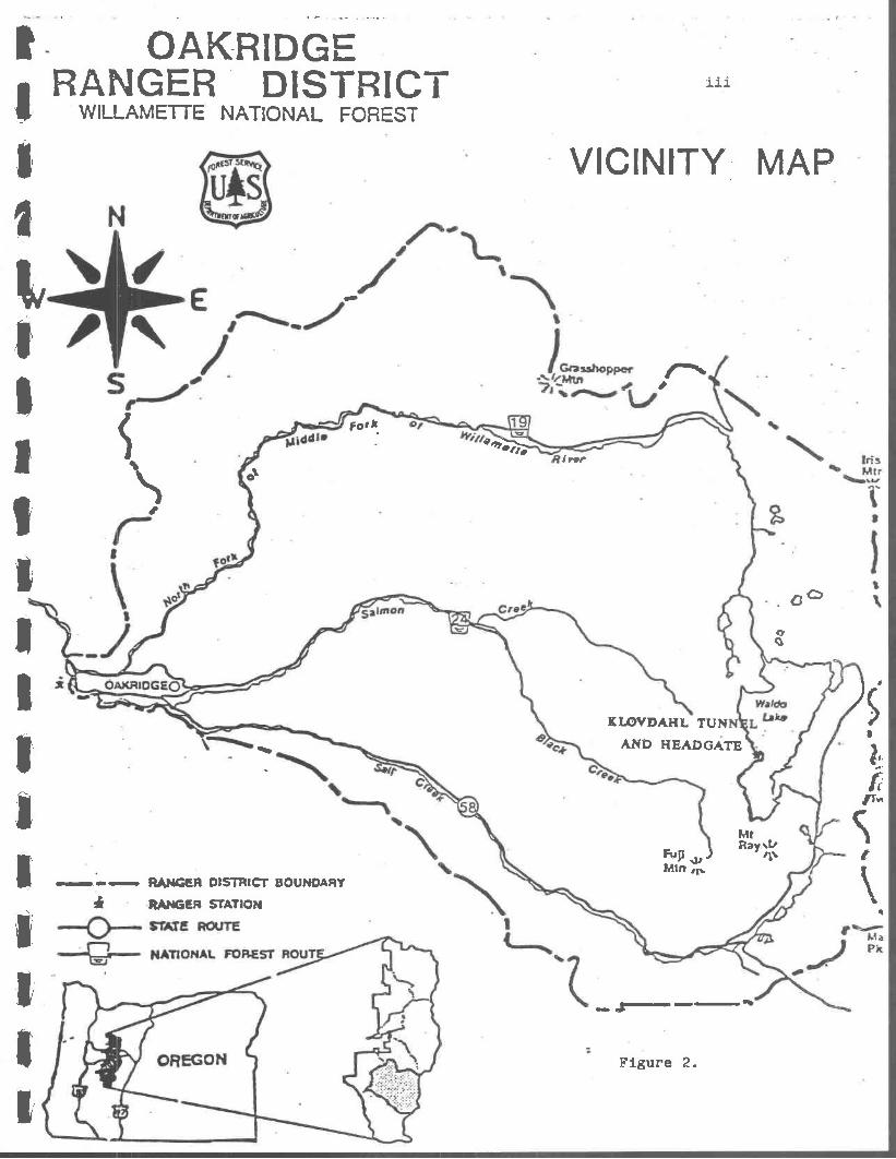
The Klovdahl Tunnel and Headgate is located at Waldo Lake, Oregon, on thewestern crest of the Cascade Mountains, roughly halfway between the state'snorth and south borders. It is approximately 63 miles east of Eugene, 75 mileswest of Bend and 165 miles from the Portland area See Figure 8). It is locatedin Township 21 & 22 South, Range 5 1/2 and 6 East, Willamette Meridian, at anelevation of 5ZI1Z feet (1640 m) above sea level and encompasses a total area of6700 acres (2680 hectares) (Figures 1 and 2). Waldo Lake is the second largest(natural) lake in the state of Oregon. It was named for Judge John BreckenridgeWaldo, an early advocate for wilderness in the central Cascade range of Oregon(MoArthur 19ZU: 629). This lake is considered one of the most oligotropic(pure) fresh bodies of water in the world (Powers et. al 1975). Since the early1960's many limnological studies have been conducted at Waldo Lake; according toMauleg et. al. (1972), Waldo Lake's "ultra-oligotropic" state has both greataesthetic value as a natural resource and significant scientific value as abaseline for worldwide limnological research.
The lake basin is the headwater for the North Fork of the Willamette River,the drainage area of the lake basin itself comprises 19,800 acres (7920hectares). It rests in a basin whose geologic origin is not well understood.P110-pleistocene glaciation and volcanic activity are likely both responsiblefor its current form. In any case, the lake is within the High Cascadesphysiographic province (Baldwin 1981, Franklin and Dyrness 1973). The soilmantle is less than one meter thick (Mauleg et. al. 1972) consisting ofmoderately weathered volcanic and glacial till, supporting a variety of mixedtimber stand communities comprised of Douglas-fir, Western white pine, variousAbles species, Western and Mountain hemlock, and Lodgepole pine. The many plantcommunities in the vicinity of the lake fall generally within the Abies amablis(Pacific silver fir, climax) coniferous forest zone (Franklin and Dyrness 1973);forming an intermediate zone between subalpine and temperate slopes of theWestern Cascades. Rainfall was recorded at 74 inches in 1914 (Frankland 1931:16) and estimated at 72 inches per year (1969-73) by the National Ocean andAtmospheric Administration (as quoted in Powers et. al. 1975:1). There are nopermanent influent streams; numerous small intermittent streams, unchannelledrun-off, probable spring sources and direct precipitation provide all of therun-off of said annual rainfall.
It has long been assumed that due to the porous nature of this volcanicregion that all of the theoretically available run-off of the drainage does notreach the lake itself (Cf. Culver 1964:2), Culver stated that, "It is estimatedthat it [the lake] would take 10 years for the lake to regain its normal levelif the water were drawn down 40 feet." (Ibid.). This fact was overlooked bothby the Waldo Lake Irrigation and Power Co. and initially by the federalgovernment, in computing the number of' acre feet available to draw-off on anannual basis. In a letter from J. C. Stevens, the USDA Forest Service District[Regional] Engineer, to Mr. F. H. Ray of Montana dated August 19, 1908, Stevensclaimed that 120,000 acre feet per annum were available based on data providedby the USDA Irrigation Branch of Experiment Stations (Klovdahl N. D.). The same
facts were contained in a document produced by the Cascade National Forest(Seitz 1909:4). A. R. Black, who filed the original appropriation of Waldo Lakewater initially claimed 100,000 acre feet with a right to store an additional150,000 (The Oregonian May 23, 1905; Klovdahl N. D.),

HISTORIC CONTEXT
The history of water resources development, specifically irrigation andwater power development, can only be traced over the last one hundred years inthe western United States. Irrigation was practiced prehistorically by NativeAmerican societies in the greater Southwest. Historically there had beenlimited irrigation as well as flood control efforts in the East, but it was notuntil the arid lands of the West were perceived as desirable for settlement,that large scale reclamation (irrigation) projects were undertaken. The federalgovernment took an active role, through the Homestead Act of 1866, to promotesuch western movement of settlers. As the Western conditions became betterknown through various federal survey reports (such as those by Major John WesleyPowell) and congresses of irrigationists, reclamation was heralded as thesaviour of the arid West, able to transform vast dry lands into profitablecroplands. Despite the efforts of politicians, reclamation promoters, andsettlers there emerged no national policy on irrigation. The federal governmentdeferred to the states the control over reclamation projects by the passage ofthe Act of July 26, 1866 (Golze 1961:16).
As early as the 1870's there were concerns expressed over the ability ofprivate enterprise to effectively develop and carry out reclamation projects.In 1873 George Peter Marsh stated that, "Such works will be seldom properly andsecurely constructed by private persons or bodies, and the management of them byindividuals and corporations, will always be liable to abuse and grosscorruption." (as quoted in Lampen 1930:19). The conservation movement had earlyfocused its attention upon the management of water resources. According to Hays(1959:5), the tension between the public interest and private enterprise wasperhaps best displayed in the water conservation movement of the latter part ofthe 19th Century. Yet, despite many attempts to develop a nationwide or Westernstates water policy, no such legal document was produced. It was not until18924, with the passage of the Carey Act (Act of August 18, 18924), that the
federal government became even indirectly involved in reclamation efforts.Whereas the Desert Land Act (Act of March 3, 1877) had provided 6240 acres ofpublic domain lands to those successful in reclaiming the land within threeyears through irrigation works, the Carey Act proceeded to grant up to onemillion acres of public domain to each desert-land state, including Oregon.This law gave the states control over the development of appropriatewater/reclamation law and the establishment of related programs and agencies.Most Western states enacted very similar laws establishing state water boardsthat reviewed the reclamation plans of private persons or corporations,forwarding approval to the Department of the Interior, who then withdrew thelands from entry, and if approved permanently segregated said lands from thepublic domain. The state board could then enter into contract with thecorporation or individuals to construct the reclamation project and oncecompleted, the alienated lands are then sold to farmers and settlers who haveentered into contractual arrangements with the reclamation company (Golze
1961:15-19).
The Carey Act was relatively ineffective in meeting the objective ofimplementing reclamation projects in the West. Direct federal involvement didnot come until 1902 with the passage of the Reclamation Act (32 Stat 388), whichamong other things establised the Reclamation Service, which later became the

Bureau of Reclamation (Goize 1961:2331, Hays 1959, Lampen 1930). Theincreasingly high costs associated with reclamation projects under the Carey Actforced private enterprises to seriously re-evaluate their financialcommitments. The Reclamation Act anticipated the fiscal limitations of stateand private promotors and initiated direct federal involvement in irrigationprojects (Goize 1961 op. cit.). The federal goal was still to turn over thedistribution of water resources to private, community or co-operative ownership,while providing federal funds to get necessary projects underway or completethose stalled for lack of money. As with the Carey Act there were provisions toprotect such projects arid distribution systems from land speculators. The
reader is reminded that this early reclamation period coincides somewhat withthe historic theme regarding land speculation and the role of the federalgovernment in Oregon's history (Cf. Minor et. al. 1982). The Eureau ofReclamation has been responsible for the development of much of the Nation'sirrigation and hydro-electric power projects since its inception, transformingarid lands into viable agricultural regions.
Various authors have suggested three general historic periods forreclamation in the West (Goize 1961, Lampen 1930, Hays 1959, Winch 1984):Development by ivate enterprise, up to 1890; State control, 1890-1902; andFederal reclamation, 1902-to the present. The Klovdahl project (190519314)falls generally within the state and federal periods, but was unique in thatfrom the start, it was wholly a private endeavor on public lands. Some
additional background information is necessary to explain this apparentcontradiction.
In the Act of 1866 the federal government gave to the states, theprerogative for establishing state water law, as stated above. Oregon, likemost other Western states, based its water law on "prior appropriation" (Cf.Hays 1959:16-17). Under Oregon Law, Section 6625 (Lord's Oregon Law 1905 C.228:IO1) a person, like A. B. Black could post public notice of waterappropriation, file it with the county clerk, and barring any objections,receive approval from the State Engineer for the development of the appropriatedwater resources so filed upon, in this case irrigation and power, free ofcharge.
Yet, despite the relative ease of acquiring water rights, the expenseinvolved in developing irrigation systems was quite high. Private developers,having reached the limits of their resources by the 1880's, turned to state andfederal government for help. The National Irrigation Congress, meeting in SaltLake City in September of 1891 resolved in favor of ceding all public domainlands to states and territories (Hays 1959:31), in part to aid in thedevelopment of reclamation, through the sale and disposition of those lands.During the Carey Act years debates in and out of Congress centered around theideas of such conservationists like Gifford Pinchot, Theodore Roosevelt andFredrick Newell, who sought tight federal control over such reclamationefforts.
When Roosevelt took over the Presidency in 1901 he made resourceconservation a national priority. He considered "IF]orests as naturalreservoirs" and that "...forest conservation is therefore an essential conditionof water conservation" (as quoted in Lampen 193O:iO). Furthermore, he believedthat the conservation of forests, and hence water, was a function of the federalgovernment not private interests (Ibid.). Pinchot and Roosevelt had long
advocated that reclamation should be controlled by the Department ofAgriculture, in fact the forestry movement had already taken up irrigation as aessential part of resource management. Other forces however were at work,particularly private interests, who saw that the newly created agency (U. S.Reclamation Service) was placed in the Department of the Interior, which wastraditionally far more sympathetic to utilitarianism rather than conservationisrri
(Hays 1959:2-260). Pinchot and Roosevelt did the next best thing; theypositioned their compatriot, Fredrick H. Newell, for appointment as Chief of theReclamation Service in 1902 (Ibid.:15, Golze:26). One point must be made clearhowever, Roosevelt's federal conservation policy was not against privateenterprise per se, only those who would unscrupulously squander and depletepublic resources for private gain. The policy of federal reclamation was totransfer the benefits of irrigation to the farms and homesteads of smalllandholders and thus strengthen the regional and national economies (Lampen
1930:k9).
Pinchot, successful in 1905 in having the vast Forest Reserves transfered tothe Department of Agriculture (where conservationism could be administered undercentralized and firm government control), sought to increase his new agency's(The Forest Service) power over reclamation efforts in lands under hismanagement. This presented tangible problems for the promoters involved in thedevelopment of Waldo Lake's reclamation potential. The Forest Service, havingjust established the Permit System in 1905, agreed only to the granting oftemporary permits for such private developments. This was a means by which to
protect the "public interest" against speculators and "looters of the publicdomain". In addition, this system required the charging of "conservation fees"for irrigation and power development (Hays 1959:7-75); a condition vehementlyobjected to by A. R. Black in his attempt to secure such as special-use permit(Seitz 1909, Klovdahl N. D.). This drama was enacted throughout the Westbetween potential permitees and the Forest Service (Hays op. cit.). Black andother promoters like him, felt that since the state had granted them freeappropriation, the federal government should grant them free use. Thissituation led Black to argue back-and-forth for over 26 months with the ForestService (1905-1908) in order to finally obtain a permit that both parties couldagree to; but it required a personal visit on Black's part to the Forester'soffice (to Pinchot and his assistant Adams) in January of 1908 (Seitz 1909,Klovdahl N. D., Cascade National Forest N. D.).
Two other items of historic context must be presented before treating theWaldo Lake project's specific history. It has already been noted thatreclamation was a relatively recent event in the history of Western states. The
development of hydro-eleetric power was even more so. It had to await thedevelopment of the science and application of electricity. It was not until the1870's that Edison's work (among other's) was recognized as having vastpotential as a practical energy source. The first commercial application ofthis process was the limited electric lighting of New York City in 1882 . By189J4 an electric hydro-power generating plant was in service at Niagara Falls,and in 1896 such power was delivered to the nearby city of Buffalo, New York(Encyclopaedia Brittanica 1981). Finally the development of effectivereclamation projects necessitated the engineering and construction of permanentand durable dams, spiliways and headgates. Modern structural concrete as usedin the Klovdahl Tunnel and Headgate, as well as most major reclamation projectsin the twentieth century, required the invention of' portland cement, an early19th Century development in the manufacture of artificial cements (Ibid.
V.10:1075).

HISTORIC SUMNARY
Back at the turn of the century, local and regional business interestslooked towards Waldo Lake as a natural and untapped reservoir with untoldpotential for economic success and regional development. Speculating onpotential monopolies over both irrigation and power development, A. H. Blackfiled notice of appropriation on 100,000 acre feet of water from the Waldo Lakedrainage basin under Oregon law in 1905 (The Oregonian May 19, 1905, Seitz 1909,Klovdahl N. D.). During that same year he applied to the Forest Service for aspecial-use permit to begin construction on a canal ("ditch") at the lake'snatural outlet, in the northwest corner (Seitz 1909, Frankland 1931, CascadeNational Forest N. D.). His stated purpose was to be able to control the lakelevel and impound additional water to provide irrigation to the WillametteValley (Ibid.). The Forest Service however suspected that Black was moreinterested in power development than irrigation and conducted a protractednegotiation with Black that lasted about 26 months (Cf. "Kent Report in CascadeNational Forest N. D.).
The actual permit was not signed until he journeyed back to Washington D.C.in January of 1908, wherein an agreement was finally reached and the permitapproved and signed by the Acting Forester, James Adams. The Forest Service wasaware that Black had applied to the City of Eugene and Lane County for anelectric street-car franchise in 190k and was denied; and that in 190-O5 he hadfiled water appropriation notices on Windy Creek near the city of Glendale,Oregon, the McKenzie River and the Willamette River for power development.Black continued to insist on the exemption from all "conservation fees" becausehis interests were initially purely for "beneficial use" and to serve as".. .demonstration works to show that the lake waters could be drawn off withthat method tditch/flashboards]" (Frankland 1931:4). The Forest Servicespecial-use files and related correspondence show that Black was attempting tosecure virtual free use regardless of his ultimate plans (Cf. Cascade NationalForest N. D.). The charge of "speculation" by the Forest Service was probablyjustified, especially considering that A. H. Black had secured no guaranteedmarkets for either irrigation or power (Ibid.).
During the years between 1905 and 1908 Black engaged the services of, SimonKlovdahl, a professional civil engineer from Eugene. By the summer of 1908 theyhad made surveys, constructed a 26 mile trail from Oakridge up Salmon Creek toWaldo Lake and had initiated the construction of the "Black Cut" at the NorthWaldo outlet (See Figure 9). Then, in July 1908, Black sold his water rightsand project to a F. N. Ray (from Helena, Montana) for the significant sum of$20,000 (Conveyance to Ray, June 22, 1908, Klovdahl N. D.). Black made asignificant profit on the sale of his "project" and in the said conveyance. He
also retained rights to 38,500 acre feet of the Waldo Lake appropriation forirrigation of his own lands in the Lowell area. Ray then sought to findinvestors in order to form a corporation to carry on the project (Ray toKlovdahl, Septemeber 1, 1908, Ibid.). In his solicitation letters he claimed tosecure with this project a virtual monopoly over irrigation and electric powerdevelopment for the Willamette Valley (See Figure 5), expecting 300% profit onceservices were delivered (80,000 acre feet of water to irrigate 60,000 acres ofcropland and I5_50,000 horsepower of power generation). Ray, Klovdahl and theirMontana and Eugene based associates probably had more in mind than simplyproviding a public service.

Waldo Lake Irrigation and Power Company was incorporated in December of 1908under the laws of the State of Montana (Personal communication, MontanaSecretary of State; Cascade National Forest N. D.). Klovdahl and Ray recognizedthat the physiography of a ridge along the western shore of Waldo Lake presenteda unique opportunity to re-direct their reclamation efforts. By 1909 theyreceived a new special-use permit from Supervisor C. Seitz of the CascadeNational Forest in order to "...construct[ing] a tunnel and headgate not lessthan 7 ft. high and 10 ft. wide on the bottom.. .for the purpose of partiallydraining Waldo Lake and storing flood waters therein...". The company againemployed the services of Simon Klovdahl to begin construction on a 500 foottunnel from the headwaters of the Black Creek drainage through this narrow ridgeof volcanic origin, connected to Waldo Lake by a concrete headgate "dam"structure. The company envisioned developing this "natural" reservoir"...without a dam" (Ibid.:1), and thus significantly reducing construction costsassociated with similar reclamation efforts. Work began in 1909. The remotewilderness location presented many difficulties for the project, chief of whichwas access and transportation. Pack string was used to keep the work campsupplied from Oakridge, 26 miles to the West (Klovdahl N. D.). Heavier
materials had to be freighted from Shaniko in Central Oregon, the nearestaccessible railhead. Shaniko at that time was considered the "Wool capital ofthe World" arid was connected to Portland and other railroad systems by theColumbia Southern Railroad (Winch 19814:3145). For K].ovdahl and his crew thisnecessitated the improvement and re-construction of existing primitive wagonroadsystems (including the building of bridges across the Deschutes and CultusRivers) over some 90 miles through Bend and on across the Cascade Crest(Klovdahl to Waldo Lake Irrigation and Power Co., April 1, 1911, Klovdahl N.D.). The existing wagonroad system had penetrated the North Waldo area prior tothe 1900's providing sheepherders access to the Western Cascades. Klovdahl thenhad to construct an additional wagonroad over 5 miles to the southeastern shoresof the lake, wherein using barges towed by a motorboat, the supplies wereferried over 1 1/2 miles across the lake to the tunnel and headgate project site(Ibid.).
Over great hardship, and the apparently tight financial conditions of thecompany, the "dam" was finally completed in 19114, with work often progressinginto the harsh winter months (See Figures 10 and 11). Sand for the cement hadto be acquired locally, which unfortunately was full of organic debris (despitewashing); this led to leakage problems, years later. Perhaps one of the mostsignificant feats was the transportation of the eight phosphor-bronze gates,forged in Eugene, to Bend (accessible by rail in 1912) and then over thewagonroad to Waldo Lake. Correspondence between Klovdahl and the companyindicates that frequently adequate funds were unavailable (deposited in theFirst National Bank of Eugene). It appears that in reality the Montana basedcorporation consisted of some financial speculators with no corporate office,who based all their operations out of Klovdahl's Eugene practice. For allintents and purposes Klovdahl's contributions between 1908/09 and 19114 producedthe only tangible evidence of corporate activity, other than a minor amount ofcompany correspondence.
The completed waterwork with its 8 bronze gates opening into a 7 x 10 foottunnel (See Figure 12), was theoretically capable of' lowering the lake by asmuch as 25 feet, once the cofferdam was removed (Frankland 1931). However,
after completion of the headgate and tunnel in 19114 no additional project workwas performed. What went wrong? How did so much human effort (the laborer's aswell as the engineer's) go to such waste. To partially answer these questionswe have to turn to some of the historical facts surrounding the corporation's"back office" dealings.
Ray had sought investors, not only to form the company and to raise capital,but to recoup his own money ($5000.00 to hold the deed of conveyance in escrow)invested in the project (Ray to Klovdahl, September 1, 1908, Klovdahl N. D.).Thus by forming the corporation Ray was relieved of any personal indebtednesswith regards to this project. His solicitation offered "equal" opportunity forthe initial investors to share in 1/10th ($25,000.00) of the necessarycapitalization and presumably in an equivalent share of the profits (Ibid.).Utilizing research conducted by A. P. Stover, then on staff at the USDAIrrigation Office at Oregon Agricultural College, that extolled the need andnecessity for irrigation in the Willamette Valley, Ray created an impressionthat the project was bound to succeed. The only factor in the way was ". . .themossback character of many land owners" in the valley (Ibid.). Ray indicates inthis document that he was "well acquainted with Mr. Stover" and has been forthree years anonymously promoting the development of irrigation in the valley(Ibid.). On a related note, in 1910 Samuel Fortier, then Chief of Irrigations,U. S. Department of Agriculture, sends the company a very laudatory letterpraising their proposed irrigation plans and stated that "...very large profitsmust accrue to the investor" (Fortier to W.L.I. & P. Co., May 18, 1910, Klovdahl
N. D.).
An examination of the company's shareholder records as of August 31, 1911shows that a certain S. Fortier holds 10 preferred shares and a Mrs. L. Stayer(of as yet unproven relation to A. P. Stover) holds 75 common shares (Op.cit.). The document also indicates that by this date the company had sold only526 and 1/2 shares of preferred stock, which valued at $100.00/share would haveprovided them with a working capital in the treasury of $52,650.00. Accordingto Ray's original solicitation, the preferred stock, which was to be use solelyfor acquiring A. H. Black's water rights and constructing the headgate, wasbarely adequate for the task (originally projected at $125,000.00). Indeed,
correspondence between Iclovdahl and the company during 1910 to 191k, indicatesthat the engineer's ability to secure supplies and make payroll was limited bythe availability of funds in the company's account (Klovdahl N. D.). By thesummer of 191z, just prior to the completion of the headgate and tunnel system(2 years behind schedule), Klovdahl resigned in part from going without salaryfor over a year, the depletion of company treasury, and the expenditure of hispersonal funds (Klovdahl to Abercrombie, August 1, 191k, Ibid.).
It appears that in 1912 Milton L. Bugbee, attempted to take over thecorporation. With the support of the other board members, he instigated thedecapitation of Ray from the Board of' Directors. Though the records areincomplete, it appears that Bugbee was successful, despite Ray's protestsagainst such a "Blue Sky" proposition (referring to the speculative nature ofBugbee's cut-rate acquisition of W. L. I. & P. Co. shares). According toKlovdahl's correspondence, there was a "falling out" between he and Ray during1912-191k. Ray died a broken man in 191k, suffering from a "nervous breakdown"(Helena Independent 191k). By 1915 a new group of investors came on the scene,with a Colonel W. H. Abercrombie, a pioneer settler of Spokane and a developerof Eastern Washington mining interests (Anonymous 1912), ascending to thepresidency. After 191k the reclamation project is basically dead in its tracks(Whistler and Lewis 1916:91). An article appearing the Oregonian in 1913creates the impression that the company was not releasing its future plans,"...[tjhe company has not specified any irrigation project.. .neither does itindicate a place for the sale of power..." (The Oregonian 1913). Besides theinternal battles with the corporate offices and tight financial conditions, twoother factors were responsible for the failure of the project.
10
The company had originally hoped that markets for its proposed electricpower generation could be found in local and interstate railway systems. Thecompany solicited the Southern Pacific Railroad in 1911 as a potential consumerfor their power, but were politely refused (Ray to Hood, June 29, 1911, KlovdahlN. D.). The Southern Pacific was extending its line between Natron and KlamathFalls, Oregon, through the Cascade Range at this time. However there was ahiatus in construction between 1912 and 1923 and so potential locally derivedsources of power were not then necessary.
The company's attempts to stir up Interest in irrigation, despite thesupport of certain influential government officials in the Department ofAgriculture, met with similar failure. There is evidence that the company hadintended to attempt to buy cropland in the valley near Eugene, develop it forirrigation, and sell it back to farmers at greatly increased prices. Earringthe cost prohibitive nature of that scheme, the secondary plan was to formirrigation districts that would then contract the company's services (Ray toKlovdahl September 1, 1908, Klovdahl N. Di. It appears that Ray and then after191Z, Bugbee continued such efforts until 1918, when a well organized group ofdemocrats and citizens formed the "Anti-Bonding Irrigation and Drainage League"in the Eugene area to oppose such efforts (The Oregonian 1918; Bugbee AffidavitAugust 19, 1927, Cascade National Forest N. D.). From existing documentaryrecords there appears to have been almost no activity after 1918, until the late
1920's. According to a letter from the State of Oregon Corporation Departmentto the Forest Service, the company failed to pay license fees after 1920(Cascade National Forest N. D., letter dated Oactober 12, 1926). An examinationof the special-uses file (Ibid.) indicates that the Forest Service and U. S.Senator George E. Chamberlain (Oregon) were conducting an investigation of theintents of the company to determine whether or not the permit should be revokedfor non-use. A "Memorandum for the Files" dated December 15, 1917 states thatthough the company has not been successful in finding a market for theirservices due to the "absence of a market", and since they have invested$93,000.00 thus far, their permit should remain intact given the fact that itmay be revoked if necessary at a later date (Ibid.).
Prior to 1918, as a result of reclamation investigations conducted undercooperative agreement between the State Engineer and the Bureau of Reclamationin 1916, the Waldo Lake project area was officially withdrawn by the State toprotect future reclamation development from entry (e.g. homestead, mining, etc.)
(Frankland 1931:9). The company was then forced to apply to the State Engineerand later the Federal Power Commission (after 1920) for the right and license tooperate its planned irrigation and hydro-power facilities. Part of therequirements for receiving such rights was to prove that the company couldprovide for "beneficial use" and could also financially see the project to itsfinal completion. The company made an exerted effort in 1927 to make good ontheir claims by petitioning the Forest Service to extend their special-usepermit (Cascade National Forest N. D.). The Forest Service had been concernedsince 1915 that the company would never be able to but their project to"beneficial use".

11
The Forest Service made an extension on their permit conditional upon therepair of the headgate structure which was by that time leaking badly. In 1927the company again hired the services of Simon Iflovdahl to effect the repair(Ibid.). The company performed its obligation satisfactorily and was granted anextension. However, because of the Federal Power Act of 1920, which created theFederal Power Commission, they were now faced with the need to pass over anotherbureaucratic hurdle. The company applied for a preliminary permit in 1927 tothe FPC. An application for preliminary permit was also filed by a competingbusiness interest from Los Angeles, California. The Waldo Lake Irrigation andPower Company made a concerted effort to develop plans for four power plantsites along Salmon Creek and the North Fork. They proposed miles of diversioncanals to channel waters from both drainages in order to harness the 10OO feetof head of water power. Their design called for the main power plant to belocated above Westfir near the Southern Pacific Railroad tracks and the WesternLumber Company mill site. They apparently had plans to ultimately develop apaper and pulp mill in the Westfir area utilizing their own power (WillametteNational Forest N. D.).
By 1933 the Federal Power Commission denied the Waldo Lake Irrigation andPower Company's application for a preliminary permit. In 1934 the ForestService terminated their special-use permit and the area reverted to ForestService jurisdiction. The company soon withered away and failed to file annualfinancial reports with the State of Montana after 1938 ( Montana Secretary of
State 1987). The Army Corps of Engineers still had plans of incorporating theWaldo project into the Willamette Basin plans up to the mid-1950's, when thepublic and the Forest Service was beginning to seek political and administrativeways to protect the lake's natural beauty and recreational potential (WillametteNational Forest 1926-6E$. However it was not until October 26, 1959 that theSecretary of the Interior, John H. Gutride, vacated the existing powerwithdrawals (No.'s 1039 and 1O'6) under Section 2 of the Federal Water PowerAct (Willamette National Forest 1971). This local chapter of the history ofreclamation in Western Oregon ended with barely a recollection of the Waldo LakeIrrigation and Power Company.
The bulk of the history of the lovdahl Tunnel and Headgate since 191I canbe found only in the form of primary and secondary historical documents. The
structure thus represents a tangible artifact of this project up to 191, andfrom thereafter as a symbol for the plans and aspirations of future commercialreclamationists. Today the the headgate and tunnel remains a tribute to theengineer and workers who struggled so hard to make the dreams of a fewwater-power speculators come true, and it is a tangible reminder that thebeautiful Waldo Lake area as we know it today could have been rendered a highlymodified ecosystem if the unfolding of history had taken a slightly differentcourse.

12
Figure 8. Aerial view of Waldo Lake from the south. Photo bySam Frear, USDA FS, Willaxnette N. F., 1971
Figure 9. View of "Black Cut" at North Waldo outlet In 1913.Photo, courtesy of the State of Oregon.

13
Figure 10, Klovdahl Headgate and construction workers in 1913.Photo, courtesy of the State of Oregon.
S

11
FIgure 11. K].ovdahl Headgate under construction in 1913, view from thecoff'erdam (west). Photo courtesy of the State of Oregon

I- 1'0R- FL..I (jOnctj
rk
If
.5?!/cMtLErE)c. C./AJ6D )
ftoVpA//L t,v4et
ttit
-1-
14
-3S
Figure 12.
Plan view of Headgate Chamber and Tunnel.
(,,(vP7,v4)

J
Figure 13.Profile of K
lovdahl Tunnel
zystem and volcanic ridge.
IIII
oo/,,,oo#.clb'QQ#Ivlb'OO'FtVoQtIvOOIII1
191C NOSVJVI71IM 0
KLOVDAHL TUNNEL and HEADGATE PROFILE
SOALI
0 40 IO
-
L) P IDO
SOCK NIDO .f VOLCANIC ONIGIN
TUNNEL - UNLINED tk-vn -
HEADGATE AND CHAMBER STRUCTURE
CONCRETE LINED - 50 FEET
H5300
-

ANALYSIS OF SIGNIFICANCE
Below, the Klovdahl Tunnel and Headgate Structure is evaluated for itseligibility to the National Register of Historic Places. This document has thusfar treated the structure's description and history for the purpose ofaddressing the specific criteria of significance as contained in 36 CFR 60 and
elaborated in How to .pplI the National Re&ister Criteria for Evaluation(National Park Service 1982 [Draft]. The following criteria elements arediscussed below; integrity, thematic representation, association withsignificant persons, and level of significance. The Klovdahl structure isdetermined to be eligible to the National Register by possessing integrity andmeeting Criteria A ("...associated with events that have made a significantcontribution to the broad patterns of our history..."), in its illustration ofthe Reclamation Period in the history of the Western states. In assessing thestructure's eligibility, the level of significance assigned to this culturalresource was local.
The Klovdahl Tunnel and Headgate structure was determined to have integrityin its retention of original design, materials, engineering, character andlocation. Despite the leakage located around the gates and portions of theheadgate structure, both historically and in the present, it is judged to bebasically sound and will likely remain so for many years to come. Currently theForest Service plans to effect a repair of the leakage as documented in theenvironmental analysis (Willamtte National Forest 1987, forthcoming). The
objective is to protect the original structure for ensuring the engineeringsuccess of the repair as well to provide for the future enhancement of thestructure as a cultural resource. Past repairs to the leakage problems in 1929,1960 and 198Z involved the application of cement repairs to the headgate walls.Most of this past repair has taken place below water level and has notsignificantly modified the structure In any visible way. It appears much like
it did upon completion in 1911, save for weathering of the concrete face, andheadgate controls (Cf. Figure 6 and 111). The tunnel is basically sound, thougha collapse of the unlined outlet had occurred during the 1930's, preliminary
engineering work in 1986 repaired the outlet and made the interior of the tunneland chamber-system accessible. The chamber-system (Figure 15) that channels thewater taken in by the gates into the tunnel appears on visual examination to beIn very good condition (Nordenson, Personal communication).
The structure is an extant representative of the Private enter2rise periodof the reclamation of Western lands. Of further importance is the fact thatthis project was developed and promoted well into the early twentieth centurywhen the role of private interests were being usurped by state and federalgovernments, specifically the State Water Board, Bureau of Reclamation and ArmyCorps of Engineers. There were concurrent reclamation efforts in Central andWestern Oregon but none in such a remote wilderness setting requiring such amonumental effort to both access and construct. There were two power plants inoperation on the nearby McKenzie River by 1916, one at Walterville supplyinghydro-electic power to the City of Eugene and a small plant on the mouth of BlueRiver that supplied the mining district in that area. Promoters had filed onClear Lake to effect a similar scheme to the Waldo Lake project but it never wasimplemented on the ground (Whistler and Lewis 1916:89-90).
17
18
The Tumalo Irrigation District surpassed the Klovdahl site in becoming anestablished reclamation project existing to the present day, despite its ownhistoric "booms and busts" (Winch 1981, 1985, 1986). Had it not been for the
failure of Willamette Valley farmers to wholeheartedly take up gravity fedirrigation (eventually relying instead on irrigation through pumping of groundwater), the untimely lack of guaranteed power markets, or the financial andmanagement problems of the Waldo Lake Irrigation and Power Company, this projectcould have become one of the most ambitious private reclamation efforts in thestate. The IClovdahl Tunnel and Headgate structure remains as an example of theattempt of private enterprise to acquire virtual free use of public naturalresources for reclamation purposes and the search for high profits, as well asan indirect testimony to the role of government (particularly the variousfederal agencies) in managing such public resources and reclamation efforts.
This historic structure is also associated with persons, both privateentrepreneurs as well as agents of the federal and state governments, who though.not infamous or well known by scholars, were nevertheless representative of theearly development of natural resources in the Western Cascades during the early20th Century. However in addressing Criteria B of the National Register, thisanalysis came to the conclusion that no individuals involved with this projectcould be identified as having reached significant standing in the history ofreclamation on account of' the Waldo Lake project. It is possible that thisproject was Simon Klovdahl's most important engineering achievement, howevermore biographical and related research would be needed to defend such a claim.The following data on the individuals involved is provided as biographicalbackground and information for future research.
Simon Klovdahl was a professional civil engineer from Eugene (1855-1932),for whom this headgate and tunnel was later named. An extensive document file,including many personal effects, is housed at the Lane County Historical MuseumLibrary (Klovdahl N. D.). To date no biographies could be located on him,however the historical community has an interest in him and his association withthe Waldo Lake area (Bob Cox, Tom MeCallister, and Lewis A. MeArthur, Personalcommunication). Fredrick H. Ray of Helena, Montana (the major stockholder andsecretary/treasurer of the company) was well known in hIs home state. He wasinvolved in various reclamation projects in Montana, created the office of"State Engineer" and the "Carey Land Act Board". By the time he becameinvolved in the Waldo Lake Irrigation and Power Co. he was Montana's Registrarof Lands (Sanders 1913:1103). Another member of the company's first board ofdirectors was H. W. Thompson, County Judge in the jurisdiction of Lane County,Oregon (History of the Bench and Bar 1910). After the "rebirth" of the companyin 191Z, the board shifted to Spokane, Washington. Colonel William H.Abercrombie (1857_1913) assumed the presidency in 1915, he was a well knownpioneer military man and settler of the nascent Spokane community in the late1800's. He was involved In both the military history of that area as well asresponsible for the development of the Metalline Falls mining district in thePend Orielle River country. As of 1913 he was the only living man to have amountain named after him, a 7200 foot peak in the vicinity of Locke, Montana,During World War I he served as Chief of Staff in the Panama Canal Zone (EasternWashington State Historical Society Biography files; History of the City ofSpokane and Spokane Country, Washington V. II 1912:100-105). The minorinvolvement of both Forest Service officials as well a such "irrigationists" inthe Department of Agriculture have already been noted.

19
There is also limited biographical information available on some of theother company officers, though none appear significant in either the history ofthis structure or the region as a whole. The author regrets that informationwas not thoroughly traced for Milton L. Bugbee, whose financial involvement andparticipation as an "engineer" from 1912 to 193k, no doubt would add a colorfulfootnote to this structure's history. Most of the biographical materialavailable on the other participants never once mentioned the Waldo Lakeproject. Of these people only Simon Klovdahl had most of his hopes and dreamswrapped up in this project. In the future, students of Lane County history maywant to expand this biographical treatment of Klovdahl, as he spent a good partof his professional life on this project and has been made a well-known legacythrough the structure and bay that bear his placename at Waldo Lake, Oregon.
CONCLUSION
Based on the National Register eligibility criteria (Criteria A) theKlovdahl Tunnel and Headgate at Waldo Lake is determined to be eligible. After
a thematic historic analysis of the history of reclamation in the WesternStates, and a consideration of the history of this cultural resource as itrelates to that theme, this hydro-engineering structure is found to possess:Integrity, to be a locally significant representative of private enterprise inthe history of the reclamation of water resources in the central WesternCascades of Oregon; and to illustrate the historic processes significant in thedevelopment of agriculture, industry and the regional economies of the Westernstates.
Unlike many historic sites this structure is as important for what it neverbecame. The Klovdahl Tunnel and Headgate was only to be an initial phase(albeit essential) in the development of an entire reclamation system along theUpper Willamette River Basin. This system would have employed miles of peristockand diversion canals, four hydro-power generating plants and untoldtransportation and related facilities. There is no doubt that if history hadunfolded more favorably for these private developers of publicly owned naturalresources, the Waldo Lake vicinity and indeed much of the Upper Willamettecountry would have been permanently effected. This would have had ramificationsin the area's economy, demography, social life and especially the naturalresources and beauty of the area that is so much in demand as an amenity valuetoday. The Klovdahl Tunnel and Headgate as a cultural resource site thus servesas a reminder of an earlier era, where the dreams and schemes of entrepreneursfocused to make their fortunes in the mountains amongst the multitude of naturalresources once thought by some to be purely commodities "for the taking". Todaythis cultural resource offers a unique opportunity to provide a non-commodityvalue to the public, through historic interpretation, repair and enhancement ofthe Klovdahl Tunnel and Headgate structure as proposed currently by theWillamette National Forest.

REFERENCES
Anonymous1910 Histo of the Bench and Bar, Portland, Or.: Historical Publishing Co.
1912 History of the City of okane and Sokane Country: Pictoral andBioghical Deluxe S2lement V.2. Spokane, Wa.: S. J. Clarke.
Baldwin, Ewart1976 Geology of Ore. Iowa: Kendall/Hunt.
Beckham, Stephen Dow1978 Identifying and Assessing Historical Cultural Resources in the Pacific
Northwest. Studies in Cultural Resource Mana&ement Mo. 2, USDA FS
Pacific Northwest Region,
Berkman, H. L. and W. K. Viscusi
1973 Daminin& the West: Rah Nader's Study Gro Rort on the Bureau ofReclamation. New York: Grossman,
Carey, Charles
1922 U LQre&on,_. Chicago: Pioneer Historical Publishing Co.
Cascade National Forest [Sic]N.D. Special-Uses File, Waldo Lake Irrigation and Power Co., 1905_314. On file
at Willamette National Forest, Eugene, Oregon.
Culver, D. H.196k Multiple Use Resource Values Within and Adjacent to Hydroelectric Power
Withdrawals at Waldo Lake. Report on file at Willamette National Forest,Eugene, Oregon.
Eastern Washington State Historical Society
1987 Biography Files. Personal communication.
Eckstein, Otto1958 Water-Resource DevelQ2.ment: The Economicpf Project Evaluation,
Cambridge: Harvard University Press.
Encyclopaedia Brittanica
198k Encyclopaedia Brittanica: Macraedia 15th Edition.
Frankland, James1931 Engineer's Report on the Application for Preliminary Permit on Salmon
Creek and North Fork, Cascade National Forest by Waldo Lake Irrigationand Power Co. On file at Willamette National Forest, Eugene, Oregon.
Franklin, Jerry and C. T. Dyrness
1973 Natural Veetation of Ore&on and Washinton. USDA General TechnicalReport PNW-8. Washington D.C.: GPO.
20
Conse GosneMovement i:12?.Q
he Progressive Conserv on
Goize, Alfred R.1961 Reclamation in the United States. Caidwell, Id.: Caxton Printers.
Hays, Samuel P.1959 rvation arid the 1 of Efficiency: T at I
Cambridge: Harvard University Press.
Helena Independent1911$ "Former Register [sic] of Land is Dead", July 7, 1914, p.6.
Johnsen, Julia1928 Federal and State Control of Water Power. The Reference Shelf, V. 5.9.
Mew York: H. W. Wilson.
Klovdahl, SimonN.D. Klovdahl Historic Documents File, Ms 235. Lane County Historical Museum
Library, Eugene, Oregon.
Lampen, Dorothy
1930 Economic and Social Aspects of Federal Reclamation. Johns HopkinsUniversittudies in Historical and Political Science, V. 8.1:v-125.
Lord's Oregon Law1905 Qreon General Laws.
Mauleg, K. W.1972 Limnological Observations on an Ultra-oligotropic Lake in Oregon, USA.
Verh. International Verein Limnolog, V. 18: 292-302.
McArthur, Lewis A.191$1$ Oregon Gerhic Mames 3d Edition. Portland: Binfords and Mort.
Minor, Rick and Audrey F. Pecor1977 Cultural Resource Overview of the Willamette Hational Forest, Western
Oregon. Universit! of Oregon Anthro2oloica1 Pacers, No. 12. Eugene,Oregon: Department of Anthropology.
Minor, Rick et. al.
1982 Prehistory and History of the Upper Willamette Valley, Oregon: ResearchQuestions and Approaches. Report to US Army Corps of Engineers, OregonDistrict, Portland Oregon.
Montana Historical Museum
1987 Personal Communication.
Montana Secretary of State1987 Personal Communication,
Moreell, Ben1956 Our Nation's Water Resources: Policies and Politics. Chicago: University
of Chicago Law School.
22
Myers, J. and A. Smith1982 Military_Census of Lane County Oreon, V. 1,2. Cottage Grove,
Oregon: Cottage Grove Genealogical Society.
National Park Service1982 [Draft] How to App the National Resister Criteria for Evaluation.
Washington D. C.: USD1 NPS.
Oregonian1905 May 26, 1905, p. 6.
1913 February 16, 1913, s. ll, p. 9,
1918 July 22, 1918, p. 3
Powers, C. F. et. al.1975 Waldo Lake. Report of Pacific Northwest Environmental Research
Laboratory EPA, Corvallis, Oregon.
Sanders, H. L.1913 A History of Montana. V. 3. Chicago: Lewis.
Seitz, C.1909 Report on Special Use Applications: Waldo Lake Irrigation and Power Co.
Permit. On file Willamette National Forest (Uses), Eugene, Oregon.
Stayer, A. P.1910 Irrigation Experiments and Investigations in Western Oregon. Bulletin
No. 226. USDA Office of Experiment Stations, Corvallis, Oregon.
Whistler, J. and J. Lewis1916 Ore&_Cerative Wor Rogue River Vally_Pro,ect and Willainette
Valley_investigations: Irriation and Drainage. USD1 Reclamation Serivceand State of Oregon. Denver, Co.: Smith Brooks.
Willainette National ForestN.D. Power Withdrawal File (2760), Waldo Lake, 1926-.196'L On file at
Willamette National Forest, Eugene, Oregon.
1971 North Waldo M. T. D. Land Use Study. Report on file at WillametteNational Forest, Eugene, Oregon.
Winch, Martin T.198Z Tumalo: Thirsty Land. Oreon Historical Quarterli, V. 85i: 31537U.
1985 Tumalo: Thirsty Land, Part 2. Ibid., V. 86.1:1679.
1985 Tumalo: Thirsty Land, Part 3. Ibid., V. 86. 2: 153-182.
1985 Tumalo: Thirsty Land, 1915-1919. Ibid., V. 86.3: 269-297.
1985 Tumalo: Thirsty Land, 1920-1931. Ibid., V. 86.: 371.1418.
1986 Tumalo: Thirsty Land, 1931-1981L. Ibid., V. 87.1: 21-66.