ultimate history of all things drones
TRANSCRIPT

New Directions in Risk and Safety
The A-Z Report on All Things Camera Drones

Prepared by: Drone with Camera Research Inc.
Definition: an unmanned aircraft system; remote-controlled pilot-less aircraft; flying thingy without people inside controlling it;
Drones

Prepared by: Drone with Camera Research Inc.
Why Fly Drones?
Aerial photography
Digital archeology
Environmental analysis
Agricultural analysis
Gas mapping
Coastal surveys
Film/media
Law enforcement
Drone racing/ first person view

Where Did the Term “Drone” come from?

The Queen Bee (DH.82B)
Gipsy Moth, one of the most common aircrafts in UK in 1929
1935 - Put radio controls on a de Havilland Tiger Moth, a successor to the Gipsy Moth
The Queen Bee (DH.82B) was one of the first returnable and reusable UAV - used as practice targets.
Aircrafts have commonly been named after insects
Prepared by: Drone with Camera Research Inc.

TDD-1 – Target Drone Denny 1
Reginald Denny career as actor and radio control model aircrafts
Contract signed with the Navy was for TDD-1
The first instance of a “ Black Drone” being associated with remotely piloted vehicle
Prepared by: Drone with Camera Research Inc.

What are Some Other Names of Drones?

What are Some Other Names of Drones?
Kettering Bug – 1918(Pre-dates the name ‘Drone’)
Radioplane - 1939
Prepared by: Drone with Camera Research Inc.

What are Some Other Names of Drones?
• Quadcopter Drone with Camera
• Multicopter
• Hexicopter
Prepared by: Drone with Camera Research Inc.

What are Some Other Names of Drones?
• Octorotor
• Hexarotor
Prepared by: Drone with Camera Research Inc.

What are Some Other Names of Drones?
• Unmanned Aircraft Vehicle - UAV
• Unmanned Aerial System – UAS
• Drones for Kids – DFK
• Best Camera Drone –BCD
• Cheap Drones with Camera –CDC
• Internationally known as Remotely Piloted Aircraft Systems (RPAS)
• UAS is the correct nomenclature for the FAA
Prepared by: Drone with Camera Research Inc.

Classification of Drones

Classification Diagram
Laws that affect aircrafts affect Model Aircrafts and Unmanned Aircrafts even for a hobby drone
Laws that affect Unmanned Aircrafts also affect Model Aircrafts
Prepared by: Drone with Camera Research Inc.

Classification of Drones
Drones classified by weight Small Drone Unmanned Aircraft System < 55 lbs
“micro” aka mini quadcopter < 4.4 lbs
Model Aircrafts classified by the purpose of only recreational Drone racing drone classified by size
Prepared by: Drone with Camera Research Inc.

Multirotor Classes for Drone Racing
Mini Multirotor Class (250 Class)
Micro Multirotor Class (180 Class)
Based on motor to motor measurement in millimeters
Prepared by: Drone with Camera Research Inc.

How Long do Drones Fly?
0
10
20
30
40
50
60
Solo IRIS+ DJI Phantom 3 DJI Phantom 4 SenseFly eBee Eagle Eye
Average Flight TimeTi
me
(Min
ute
s)
Prepared by: Drone with Camera Research Inc.

Flying Drones!

What Permissions are Needed to Legally Fly?
• Federal Aviation Administration (FAA) - must register vehicle with FAA and have authorization for drone flying
• Section 333 – any aircraft operation in national airspace requires a certificated and registered aircraft, a licensed pilot, and operational approval for flying drones
• Certificate of Waiver or Authorization (COA) - authorization by Air Traffic Organization for specific UA activity
• Part 107 (Proposed Law) - simplifies current laws, will be announced by end of JUNE 2016 for all types of drones
Prepared by: Drone with Camera Research Inc.

What Items Do You Need To Legally Fly?
• Recreational• License number registered with FAA displayed on aircrafts
• Registration fee $5 per person
Prepared by: Drone with Camera Research Inc.

What Items Do You Need To Legally Fly?
• Commercial• Section 333 Exception or Aircraft Certification
• Certificate of Authorization (COA)
• Aircraft Registrations and Markings
• Pilot Certificate
• Registration $5 per aircraft
Prepared by: Drone with Camera Research Inc.

What Items Do You Need To Legally Fly?
• As a public Agency• Certificate of Authorization (COA)
• Aircraft Registration and Markings
• Registration $5 per aircraft
Prepared by: Drone with Camera Research Inc.

What Items Do You Need To Legally Fly?
• As a UC Agent• Depending on purpose, either commercial or public
• Best to assume commercial, unless under specific purposesCommon Public Purposes
• Law Enforcement or Search and Rescue • Publically funded research on:
• Aerospace • Biological resource management • Geological resource management
Legal permissions to fly a UAS is not a trivial situation. Please contact UAS Safety for guidance!
Prepared by: Drone with Camera Research Inc.

23
Recreational/Class Curriculum
Recreational
• Cannot receive money or compensation
• Cannot be used in furtherance with a business or official duty
• Must be operated within a community-based set of safety guidelines and within the programming of a nationwide community-based organization
Education
• Students may build and fly a UAS as a component of a course curriculum or senior project
• UAS flights by students must be in accordance with Campus oversight.
• UAS flights in pursuit of research projects or university business are not considered recreational
Prepared by: Drone with Camera Research Inc.

24
Examples
• A student club is considered recreational
• A student that flies a UAS as part of a class on remote sensing techniques is considered recreational
• A student building and flying a UAS as part of a class on aerodynamics is considered recreational
• A student building and flying a UAS for a senior project is considered recreational
• A student club that is paid to perform at an event is not recreational
• A student flying a UAS under the direction of a faculty’s research is not recreational.
• A course where the primary objective is learning how to fly is not considered recreational.
• A student conducting sponsored research (faculty, company, student gov’t) is not recreational
Campus should still provide oversight!
Prepared by: Drone with Camera Research Inc.

25
Section 333 Exemption vs Public COA
Section 333 Exemption – Commercial
• Only FAA-approved Aircraft
• Requires a Pilot’s License drones with GPS
• Operations within 5 Miles of an airport requires further FAA authorization
• ~ 60 days
Public COA – Public Agency Operations
• Public Aircraft (owned by UC)• UC certifies Airworthiness
• Public Purpose• Law Enforcement, Search & Rescue,
Aerospace Research, Biological Resource Management, Geological Resource Management of drone RC
• Operations in Class G airspace can be authorized by the UC
• UC may petition for ANY UAS operation• Night Flying, Beyond Line of Sight, Delivery
Services, Above 400 ft
• Takes 3-8 months to approve
Both options have a nation-wide blanket authorization under certain conditions for immediate approval by the Center
Best for Research, Engineering and LEOs
Best for Facilities, Videography, Corporate Partnerships
Either option requires the UC to report all operations to the FAA!
Prepared by: Drone with Camera Research Inc.

26
Cheat Sheet (Also a handout)User Group/Purpose Model
Aircraft
Public
COA
Section
333
Part 107
Athletics - Over Game Currently not legally allowed
Athletics - Over Practice X
Athletics Promotional Video – Controlled
EnvironmentX
Campus Law Enforcement X X X
Campus Search & Rescue X X X
Campus Video Production X X
Construction Survey X X
Engineering Research Project (Faculty
Directed)X* X X
External Contractor X X
Flying over a access-controlled consenting
peopleX* X
Flying over non-participating people Currently not legally allowed
Flying within 5 NM of an Airport Requires Additional Clearance ^
Internal Service Provider X* X X
Research Project on Aeronautical Research X X X
Research Project on Agriculture X* X X
Research Project on Biological Resource
Management X X X
Research Project on Digital Archeology X* X X
Research Project on Geological Resource
ManagementX X X
User Group/Purpose Model
Aircraft
Public
COA
Section
333
Part 107
Research Project on Wildlife Monitoring X X X
Student Body X X X
Student Class Project X X X
Student Club X X X
Student Demonstration at Campus Event X+ X X
Student Dissertation Project X* X X
Student in an Aviation Class X X X
Student Journalist with Campus Media X X
Student Journalist with Student Government X X
Student Providing a Commercial Service X X
Student Research Project (Funded by External
Agency)X* X X
Student Research Project (Funded by Faculty) X* X X
Student Research Projected (Funded by
Student Gov’t)X* X X
Student Thesis Project X* X X
Video Production for Campus Showcase X X
Prepared by: Drone with Camera Research Inc.

UC User Flight Workflow
Flight RequestTo Center (UC form)
File special permission with FAA
Clear Airspace?
Where:When:Purpose:Pilot:Aircraft:
Aircraft Registered?
Licensed Pilot
File NOTAM (online system)
Flight Authorized
Flight Report (UC form)
Flight!
UC UAS Fleet Management System under development!
Prepared by: Drone with Camera Research Inc.

Where can we fly?

Where is it legal to fly? Where is it safe to fly?
Legal
• Class G airspace drone aerial photography
• Under 400 ft altitude
• Within Line of Sight
• Outside of 5 NM of an airport
• Other locations will require additional FAA authorization
Safe
• No flying over non-participants
• Area should be secured or very likely to have no incursions
• Spectators should be • 65 ft away for planes
• 25 ft away for multirotors (quadrotors)
Airspace mapping solutionwww.airmap.com
Prepared by: Drone with Camera Research Inc.

Airspace Classifications
Prepared by: Drone with Camera Research Inc.

UCI Airspace
• Class C
• John Wayne Airport
• Surrounded by helipads
Prepared by: Drone with Camera Research Inc.
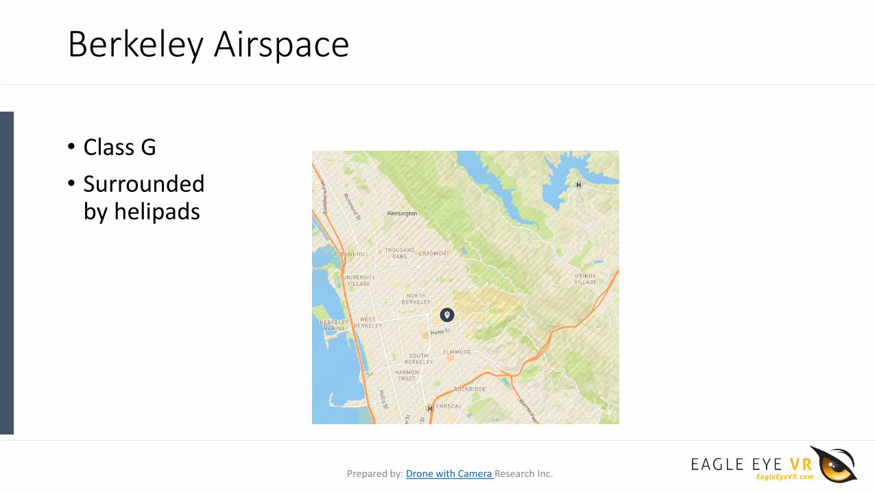
Berkeley Airspace
• Class G
• Surrounded by helipads
Prepared by: Drone with Camera Research Inc.

UCLA Airspace
• Class D
• Surrounded by helipads
Prepared by: Drone with Camera Research Inc.

UCSD Airspace
• Class B
• But also within 5 NM of an airport
• And also next to helipads
Prepared by: Drone with Camera Research Inc.

UCD Airspace
• Class G • But within 3 nautical miles
of Davis airport
Prepared by: Drone with Camera Research Inc.

California
• www.airmap.com
• Airspace in CA is more complicated than anywhere else in the US
• Metropolitan areas + National Parks
• 10% of all airports in the US are in CA
Prepared by: Drone with Camera Research Inc.

Quadcopter Anatomy(the simplest of the drone family)

Quadcopter Anatomy
Prepared by: Drone with Camera Research Inc.

Quadcopter Anatomy
A. Props B. Motors
• best drone with camera and props
typically consist of two puller and two
pusher props
• pushers rotate in opposite direction
of pullers to allow for flight•“standard” also used to describe puller
•Also known as propellers, rotors
•quadcopters use motors to turn
propellers •Brushed- cheaper but cheaper quality
•Brushless – typically higher quality;
more complicated;
Prepared by: Drone with Camera Research Inc.

Quadcopter Anatomy
C. Electronic Speed Controller D. Flight Controller/ Autopilot
•Needed to control the brushless
motors
•Abbreviated ESC
•Assists manual flights along with
some autonomous function
Prepared by: Drone with Camera Research Inc.

Quadcopter Anatomy
E. Airframe F. Battery Pack
•consists of the housing enclosing the
electronics, motor booms(arms), and
platform
•Also called “chassis”
•powers the quadcopters electronics
and keeps propellers turning•often Lipoly battery
Prepared by: Drone with Camera Research Inc.
Quadcopter Anatomy
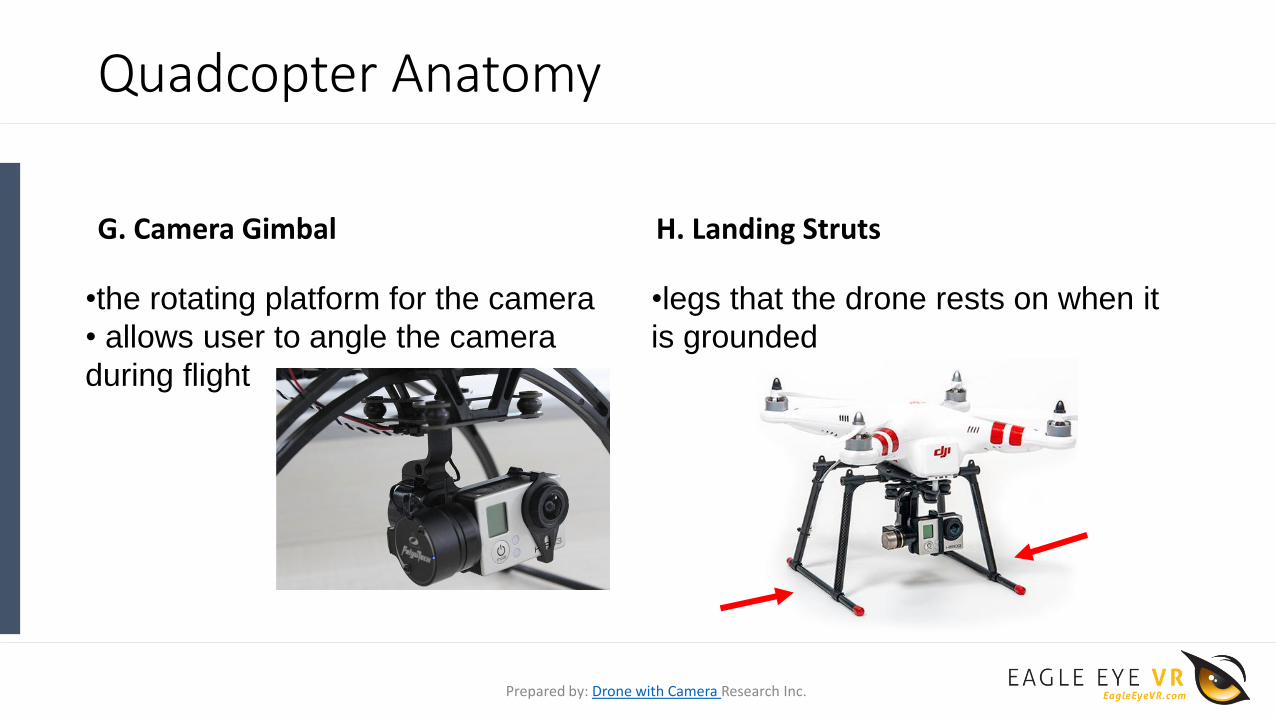
G. Camera Gimbal H. Landing Struts
•the rotating platform for the camera
• allows user to angle the camera
during flight
•legs that the drone rests on when it
is grounded
Prepared by: Drone with Camera Research Inc.

Quadcopter Anatomy
I. Front Indicator J. First-Person Video Camera
•operators use different methods to
indicate the front of the UAV such as• LEDs
•reflective material
•different colored props
•and so on
•camera that allows images to be
transmitted to the user
Prepared by: Drone with Camera Research Inc.

Quadcopter Anatomy
K. Receiver
•Translates the user’s instructions for
the flight controller
Prepared by: Drone with Camera Research Inc.

Quick Review!
• Many drones for sale with camera and GPS can be built from a kit of different motors and airframes
• LiPo batteries can explode and pose a minor fire risk
• The cost of the drone is fairly split between the• Batteries ($150 for a good one)
• Motors ($30 x 4)
• Flight controller ($60-$300)
• Camera gimbal ($60-250)
Kits make it easy to replace parts. Great for the end-user, challenging to keep track of
Prepared by: Drone with Camera Research Inc.

Inner Electronics of a Drone(What makes the Flight Controller Work)

Inner Electronics of a Drone
A. Microcontroller
• The microcontroller is the brains of the flight controller
• Collects measurements from all of its sensors (more on those later)
• Tells the motors what to do based on both the sensors and the user inputs (* also for RC predator drone with camera)
• Often connected to a ground station through a radio and connected to a human pilot through a remote control link (more on those later)
Prepared by: Drone with Camera Research Inc.

Inner Electronics of a Drone
B. Inertial Measurement Unit C. Global Positioning System
•necessary for autonomous flights
•Incorporates Accelerometer, Gyroscope, Compass
•Abbreviated IMU
•provides location and time information
•Abbreviated GPS
Prepared by: Drone with Camera Research Inc.

Inner Electronics of a Drone
D. Attitude & Heading Reference System
E. Transmitter for RTF Drone
•tells where the aircraft is moving and what orientation it is in
•Abbreviated AHRS
•Transmits the instructions to the receiver via radio waves
Prepared by: Drone with Camera Research Inc.

How to Operate a Drone

How to Operate a Drone
Visual Observer
Pilot in Command Ground Control Station
Crew Member
Control & Communication Link
RC & Safety Link PIC – Pilot in Command
Ground Control Station (GCS)
Visual Observer (VO)
Radio
Safety Link / RC Communication
Control & Communication (C2)
Prepared by: Drone with Camera Research Inc.
UAS Operation
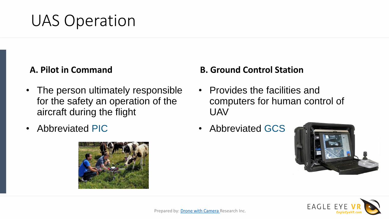
A. Pilot in Command B. Ground Control Station
• The person ultimately responsible for the safety an operation of the aircraft during the flight
• Abbreviated PIC
• Provides the facilities and computers for human control of UAV
• Abbreviated GCS
Prepared by: Drone with Camera Research Inc.

UAS Operation
C. Visual Observer
• Secondary person to watch the sky for intruding aircrafts and watch the unmanned aircraft
• Common practice to have a visual observer
• Abbreviated VO
Prepared by: Drone with Camera Research Inc.

UAS Operation
Control & Communication RC Link
Prepared by: Drone with Camera Research Inc.

UAS Operation
E. Control & Communication
• Flight controller used for control
• Communication between flight controller and ground station typically done by radio
• Abbreviated C2
F. Safety Link & RC Communication
• Safety Link typically RC transmitter link
• Could also be a different process, such as
• Radio signal
• Digital wifi
• Linked to RC Communication
Prepared by: Drone with Camera Research Inc.

Drone Rotational Motion
• Roll- rotation along the y axis
• Pitch- rotation about the x axis
• Yaw- rotation about the z axis
Prepared by: Drone with Camera Research Inc.

Common UAS Key Terms(Marketing terms, special features, add-ons)

UAS Operations Key Terms
A. Autonomous B. Altitude Hold Function
• acting independently; without human control – cheap drone
•UAV maintained at consistent altitude while roll, pitch, and yaw still changeable
Prepared by: Drone with Camera Research Inc.

UAS Operations Key Terms
C. Return to Home D. Waypoint Navigation
• Function used to sent the UAV back to the takeoff position
• UAV flies to GPS points this is my first drone and it worked perfect
Prepared by: Drone with Camera Research Inc.

UAS Operations Key Terms
E. Manual Control F. Payload
•Flies by Not Waypoint Navigation
•Someone is controlling the direct motion
•Equipment being carried, such as:
•Camera
•Air measurements
•Lasers
•And so on
Prepared by: Drone with Camera Research Inc.

UAS Operations Key Terms
H. Fly-Away ProtectionG. Geofence
• GPS tells drone to never go outside the GPS range
• Marketing Term used for
• Geofencing
• Autolanding
Prepared by: Drone with Camera Research Inc.

UAS Operations Key Terms
I. Intelligent Orientation Control J. Sense and Avoid
• The forward direction of the UAV is the same as the recorded nose direction, “home point”
•UAV uses sensors to maneuver around obstacles and avoid collision, can use:
•Cameras
•Ultrasonic sensors
•Lasers
Prepared by: Drone with Camera Research Inc.

UAS Operations Key Terms
K. Visual Tracking L. Fail-Safe
•Using cameras to control the roll, pitch, and yaw to track a moving object
•Prevents crash in the event of unsafe situation, such as:
•Loss of GPS signal
•Loss of Radio Control Signal
•Low Battery
Prepared by: Drone with Camera Research Inc.

UAS Operations Key Terms
M. Arming N. Ultrasonic Sensors
•Armed aircraft is ready to fly and motors will spin when throttle is applied cheap FPV drone
•Used as a safety mechanism
•Equipment used for range measurements by sending and receiving a signal
•Example:
•Bats
•Drone collision avoidance
Prepared by: Drone with Camera Research Inc.

UAS Operations Key Terms
O. Optical Flow P. Above Ground Level
• Used to improve stability using a camera to detect the direction of motion
•Indicates where the zero level or reference altitude is located
•Abbreviated AGL applies to large drones for sale too
Prepared by: Drone with Camera Research Inc.

UAS Operations Key Terms
Q. First Person View
•Drone racing
•Watch video it’s fun
Prepared by: Drone with Camera Research Inc.

UAS Operations Key Terms
R. Line of Sight S. Beyond Line of Sight
•Straight line along which the observer has unobstructed view
•Abbreviated LOS
• Operator and UAV too distant or obstructed
• Abbreviated BLOS
Prepared by: Drone with Camera Research Inc.

UAS Operations Key Terms
T. No Fly Zone U. Notice to Airman
•Designated area where aircrafts may not fly even using the best small quadcopter
•Abbreviated NFZ
•Notice filed to aviation authority to notify aircraft pilots of:
•potential hazards along flight route
•locations associated with the flight
•Abbreviated NOTAM
Prepared by: Drone with Camera Research Inc.

UAS Operations Key Terms
V. Air Traffic Control W. National Airspace System
•Directs aircraft traffic through controlled airspace
•Abbreviated ATC
• Airspace, navigation facilities and airports of the United States along with their rules and regulations
• Abbreviated NAS
Prepared by: Drone with Camera Research Inc.

UAS Operations Key Terms
X. Total Flight Restriction
•Occurs when the FAA shuts down airspace
•Announced by FAA
•Cannot be requested
•Can occur at times of
•Large stadium events
•President arriving in a city
•And so forth
Prepared by: Drone with Camera Research Inc.

What Can Go Wrong?

Things That Go Wrong
• Pilot Error!
• Too windy
• Loss of communication
• Fly-away – Automated system error
• Loss of GPS
• Loss of Altitude (IMU failure)
Prepared by: Drone with Camera Research Inc.
