udp (full text) - halton borough councilfulltext)prt.pdf · tp19 air quality tp20 liverpool airport...
TRANSCRIPT

1
HALTON UNITARY DEVELOPMENT PLAN
C.W.BroughOperational Director - PlanningEnvironment DirectorateHalton Borough CouncilRutland HouseHalton LeaRuncornCheshireWA7 2GWAdopted 7th April 2005www.halton.gov.uk/forwardplanning/haltonudp
2
HALTON UNITARY DEVELOPMENT PLANINTRODUCTION AND CONTEXT
FOREWORDThe Halton's Unitary Development Plan (UDP) playsan important part in achieving the community's visionfor the future of Halton that will be a thriving andvibrant borough where people enjoy a good quality oflife with:
Good health;
A high quality, modern urban environment;
Opportunity for all to fulfil their potential;
Greater prosperity and equality; and
Safe and attractive neighbourhoods.
Community involvement and participation has been atthe centre of the plan preparation process from thestart. The UDP reflects as far as possible the ambitionsand concerns of people for a good supply of new jobsand housing balanced by the protection andenhancement of Halton's built and natural assets.
The new Planning and Compulsory Purchase Act 2004has introduced a new development plans system.Although the Halton UDP policies will be 'saved'under the new Act, these changes mean thatdevelopment plans such as the UDP will progressivelybe superseded, not by a single revised plan but insteadby a Local Development Framework comprising anumber of different planning documents. The Councilhas now begun work on these new plans and willcontinue to plan for the future in partnership with thewhole community of Halton aiming to achieve thecommunity's vision for the future as set out in theCommunity Strategy.
Councillor Tony McDermott - Leader of the Council
Councillor Rob Polhill - Executive Board Member
HISTORY OF THEUDP PREPARATIONThe adoption of Halton's Unitary Development Plan(UDP) in April 2005 is a significant event in theCouncil's history since it became a unitary authority in1998. It now completes the Local Authority's strategicand local planning policy framework and replaces theplanning policies of the Halton Local Plan and theCheshire Structure Plan 2001.
A dedicated team of officers and councillors workingtogether has prepared the UDP. The officer's teamhas been led by Chris Brough (Operational DirectorPlanning) and Andrew Pannell (Divisional ManagerForward Planning). The Councillors have been led byCouncillor Tony McDermott, (Leader of the Council)and Councillor Rob Polhill, (Executive Board member).This team has worked hard to ensure that the Plan'spreparation has involved the participation of the wholecommunity of Halton.
Work began on the Unitary Development Plan withthe publication of a video and key issues report in1999 to stimulate public participation in shaping theaims, objectives and policies of the UDP. This wasfollowed by extensive periods of public consultationon the 1st Deposit Version published in September2000 and the 2nd Deposit Version published inDecember 2001.
The UDP was prepared in parallel with the RegionalPlanning Guidance or the North West (RPG 13), nowre-named Regional Spatial Strategy (RSS), which theSecretary of State approved in March 2003. TheCouncil has ensured that the UDP is in conformitywith the policies of RSS.
A local public inquiry into objections to the UDP washeld between January and July 2003. The Inspector'sReport of the Inquiry was received in January 2004 andthe following July the Council agreed a statement ofDecisions and Modifications to the UDP followingconsideration of the Inspector's recommendations.
A further period of public consultation on thedecisions and proposed modifications in response tothe Inspector's Report was held during September andOctober 2004. This resulted in further modificationsthat were subjected to more public consultation andthe results reported back to Council in March 2004.The Council finally resolved to adopt the UDP on 7thApril 2005 as the new statutory development plan forHalton.
C.W. Brough Operational Director - Planning

3
CONTENTSPage4 Index of Policies7 Preface8 Introduction and Context8 The Borough of Halton- History and Geography9 Social and Economic Characteristics10 Planning Problems and Issues14 Policy Context14 Background14 Regional Spatial Strategy for the North West14 Local Policy Context15 Sustainable Development Context
UNITARY DEVELOPMENT PLAN PART 118 Introduction19 Aims, Objectives and Indicators24 Spatial Strategy31 Strategic Policies (Part 1 Policies)
UNITARY DEVELOPMENT PLAN PART 251 Chapter 1 Regeneration63 Chapter 2 Built Environment91 Chapter 3 Green Environment123 Chapter 4 Pollution and Risk135 Chapter 5 Minerals and Waste Management153 Chapter 6 Transport171 Chapter 7 Leisure, Tourism & Community Facilities181 Chapter 8 Shopping and Town Centres199 Chapter 9 Housing223 Chapter 10 Employment238 Appendix 1 Transport Parking Standards240 Appendix 2 Housing Allocations (2002/2016)241 Appendix 3 The Town & Country Planning
(use classes order) 1987242 Appendix 4 The Town & Country Planning
(use classes order) 2005243 Appendix 5 Glossary
MAPS8 Map 1 Halton’s Location38 Map 2 New Crossing of the River Mersey 55 Map 3 Regeneration Action Areas77 Map 4 Environmental Priority Areas82 Map 5 Conservation Areas113 Map 6 Landscape Value118 Map 7 The Mersey Forest159 Map 8 Transport Proposals193 Map 9 Primary & Secondary Shopping
Frontages195 Map 10 Neighbourhood Shopping Centres213 Map 11 Proposed Housing Development Sites230 Map 12 Proposed Employment Development
Sites

4
HALTON UNITARY DEVELOPMENT PLANINTRODUCTION AND CONTEXT
INDEX OF POLICIESPolicy No. Policy NameS1 RegenerationS2 The Built EnvironmentS3 The Green EnvironmentS4 Pollution and HealthS5 Major Accident Land Use RiskS6 Reuse and Remediation of Previously
Used or Contaminated LandS7 Minerals and WasteS8 Sustainable Waste Management FacilitiesS9 Waste Management FacilitiesS10 Reducing Greenhouse Gas EmissionsS11 Renewable Energy SourcesS12 Areas at Risk from FloodingS13 TransportS14 A New Crossing of the River MerseyS15 Leisure and TourismS16 Retail HierarchyS17 Retail DevelopmentS18 Provision of Land for HousingS19 Provision of Land for EmploymentS20 Regional Investment SitesS21 Green BeltS22 Unallocated Land in Urban AreasS23 Open CountrysideS24 Sustainable Urban ExtensionsS25 Planning Obligations
Chapter 1 - RegenerationRG1 Action Area 1 - Southern WidnesRG2 Action Area 2 - Central WidnesRG3 Action Area 3 - Widnes WaterfrontRG4 Action Area 4 - Runcorn and Weston
DocklandsRG5 Action Area 5 - HalebankRG6 Action Area 6 - Castlefields and Norton
Priory
Chapter 2 - Built EnvironmentBE1 General Requirements for DevelopmentBE2 Quality of DesignBE3 Environment Priority AreasBE4 Scheduled Ancient MonumentsBE5 Other Sites of Archaeological ImportanceBE6 Archaeological EvaluationsBE7 Demolition of Listed BuildingsBE8 Changes of Use of Listed BuildingsBE9 Alterations and Additions to Listed
Buildings
BE10 Protecting the Setting of Listed BuildingsBE11 Enabling Development and the
Conservation of Heritage AssetsBE12 General Development Criteria -
Conservation AreasBE13 Demolition in Conservation AreasBE14 Outline Applications - Conservation
AreasBE15 Local List of Buildings and Structures of
Architectural and Historic InterestBE16 Alterations to and New Shop Fronts BE17 Advertising and Advertisements BE18 Access to New Buildings Used by the
PublicBE19 Disabled Access for Changes of Use,
Alterations and ExtensionsBE20 Disabled Access in Public PlacesBE21 Telecommunications ApparatusBE22 Boundary Walls and FencesBE23 Temporary Buildings
Chapter 3 - The Green EnvironmentGE1 Control of Development in the Green
BeltGE2 Hale Village Green BeltGE3 Extensions, Alterations and Replacement
of Existing Dwellings in the Green BeltGE4 Re-use of Buildings in the Green BeltGE5 Outdoor Sport and Recreation Facilities in
the Urban Fringe and Open CountrysideGE6 Protection of Designated GreenspaceGE7 Proposed Greenspace DesignationsGE8 Development within Designated
GreenspaceGE9 Redevelopment and Changes of Use of
Redundant School BuildingsGE10 Protection of Linkages in Greenspace
SystemsGE11 Protection of Incidental GreenspacesGE12 Protection of Outdoor Playing Space for
Formal Sport And RecreationGE13 Intensifying Use of Existing Outdoor
Sports and Recreation ProvisionGE14 Noisy Outdoor SportsGE15 Protection of Outdoor Playing Space for
ChildrenGE16 Protection of AllotmentsGE17 Protection of Sites of International
Importance for Nature ConservationGE18 Protection of Sites of National Importance
for Nature Conservation

5
HALTON UNITARY DEVELOPMENT PLANINTRODUCTION AND CONTEXT
GE19 Protection of Sites of Importance forNature Conservation
GE20 Protection and Creation of Local NatureReserves
GE21 Species ProtectionGE22 Protection of Ancient WoodlandsGE23 Protection of Areas of Special Landscape
ValueGE24 Protection of Important Landscape
FeaturesGE25 Protection of PondsGE26 Protection of HedgerowsGE27 Protection of Trees and WoodlandGE28 The Mersey ForestGE29 Canals and RiversGE30 The Mersey Costal Zone
Chapter 4 - Pollution and RiskPR1 Air QualityPR2 Noise NuisancePR3 Odour NuisancePR4 Light Pollution and NuisancePR5 Water QualityPR6 Land QualityPR7 Development Near to Established
Pollution SourcesPR8 Noise Sensitive DevelopmentsPR9 Development within the Liverpool
Airport Public Safety ZonePR10 Development within the Liverpool
Airport Height Restriction ZonePR11 Development of Sites Designated under
the Control of Major Hazards (Planning)Regulations 1999 (COMAH)
PR12 Development on Land SurroundingCOMAH Sites
PR13 Vacant and Derelict LandPR14 Contaminated LandPR15 GroundwaterPR16 Development and Flood Risk
Chapter 5 - Minerals and WasteManagementMW1 All Minerals and Waste Management
DevelopmentsMW2 Requirements for all ApplicationsMW3 Requirements for all Waste Management
ApplicationsMW4 Aggregate MineralsMW5 Protection of Mineral resources
MW6 AftercareMW7 Waste Recycling and Collection FacilitiesMW8 Aerobic Composting FacilitiesMW9 Anaerobic Digestion FacilitiesMW10 Wastewater and Sewage Treatment
FacilitiesMW11 Extensions to Wastewater Treatment
FacilitiesMW12 Recycling and Household Waste CentresMW13 Energy RecoveryMW14 IncinerationMW15 Landfill/Landrising of Non-inert WastesMW16 Landfill/Landrising of Inert WastesMW17 Waste Minimisation and RecyclingMW18 Energy from Non-fossil Sources
Chapter 6 - TransportTP1 Public Transport Provision as Part of New
DevelopmentTP2 Existing Public Transport FacilitiesTP3 Disused Public Transport FacilitiesTP4 New Public Transport FacilitiesTP5 Taxi Ranks and OfficesTP6 Cycle Provision as Part of New
DevelopmentTP7 Pedestrian Provision as Part of New
DevelopmentTP8 Pedestrian Improvement SchemesTP9 The Greenway NetworkTP10 The Trans-Pennine Trail and Mersey WayTP11 Road SchemesTP12 Car ParkingTP13 FreightTP14 Transport AssessmentsTP15 Accessibility to New DevelopmentTP16 Green Travel PlansTP17 Safe travel for AllTP18 Traffic ManagementTP19 Air QualityTP20 Liverpool Airport
Chapter 7 - Leisure,Tourism andCommunity FacilitiesLTC1 Developments of Major Leisure and
Community Facilities within DesignatedShopping Centres
LTC2 Developments of Major Leisure andCommunity Facilities on the Edge ofDesignated Shopping Centres
LTC3 Development of Major Leisure and

6
HALTON UNITARY DEVELOPMENT PLANINTRODUCTION AND CONTEXT
Community Facilities in Out-of-Centrelocations
LTC4 Development of Local Leisure andCommunity Facilities
LTC5 Protection of Community FacilitiesLTC6 Children’s Day Care ProvisionLTC7 The Proposed Halton Arts and Cultural
Centre SiteLTC8 Protection of Tourism AttractionsLTC9 Tourism DevelopmentLTC10 Water Based Recreation
Chapter 8 - Shopping and Town CentresTC1 Retail and Leisure AllocationsTC2 Retail Development to the Edge of
Designated Shopping Centres TC3 Warrington Road/Eastern Widnes Bypass
SiteTC4 Retail Development within Designated
Shopping CentresTC5 Design of Retail DevelopmentTC6 Out of Centre Retail DevelopmentTC7 Existing Small Scale Local Shopping
Facilities Outside Defined ShoppingCentres
TC8 Non-retail Uses within Primary andSecondary Shopping Areas
TC9 Non-retail Uses within NeighbourhoodCentres
TC10 Runcorn Mixed Town Centre Uses AreaTC11 Food and Drink Outlets
Chapter 9 - HousingH1 Provision for New HousingH2 Design and Density of New Residential
DevelopmentH3 Provision of Recreational GreenspaceH4 Sheltered HousingH5 Gypsy SitesH6 House ExtensionsH7 Conversions to FlatsH8 Non Dwelling House Uses
Chapter 10 - EmploymentE1 Local and Regional Employment Land
AllocationsE2 Priority Employment Redevelopment
AreasE3 Primarily Employment AreasE4 Complementary Services and Facilities
within Primarily Employment Areas
E5 New Industrial and CommercialDevelopment
E6 Daresbury LaboratoriesE7 Ditton Strategic Rail Freight Park

7
HALTON UNITARY DEVELOPMENT PLANINTRODUCTION AND CONTEXT
PREFACEHalton BBorough CCouncil bbecame aa nnew UUnitary AAuthority iin AApril 11998 aand tthis iis iitsfirst UUnitary DDevelopment PPlan ((UDP). TThe UUDP ccombines bboth sstrategic aand llocalplanning ffunctions aand ttherefore ccontains aall tthe pplanning ppolicies rrelevant tto HHalton.These ppolicies pprovide tthe gguidance, iincentive aand ccontrol ffor tthe ddevelopment aand uuseof lland iin HHalton uup tto aand bbeyond 22016.
1 The Unitary Development Plan (UDP)contains two parts. Part 1 consists of a writtenstatement of Halton’s strategic planningpolicies. This then forms the framework forthe detailed proposals for the use anddevelopment of land in Part II of the Plan.
2 The Halton Unitary Development plan wasadopted as the Borough’s StatutoryDevelopment Plan on 7th April 2005. Itreplaces the previous statutory developmentplan that was comprised of the Halton LocalPlan (adopted in April 1996) and the CheshireReplacement Structure Plan (1992), CheshireMinerals Local Plan (1987) and the CheshireWaste Disposal Plan (1987).
3 Under the transitional arrangements of thePlanning and Compulsory Purchase Act 2004the adopted Halton Unitary DevelopmentPlan will retain development plan status and itspolicies will automatically become ‘saved’ for aperiod of three years from adoption. Duringthe three-year period the Council will bringforward ‘local development documents’(which form the ‘local developmentframework’) prepared under the new Act toreplace saved policies. This will be done inaccordance with a programme for theproduction of ‘local development documents’known as the Halton Local DevelopmentScheme.
4 Where it can be demonstrated to theSecretary of State that that the saved policiesin the Halton UDP reflect the principles of‘local development frameworks’ and that it is not feasible or desirable to replace themwithin the three year period, it will be possibleto seek the Secretary of State’s approval toextend them as part of a review of the HaltonLocal Development Scheme.
5 The Halton UDP also conforms with theRegional Planning Guidance for the NorthWest (RPG13) that was published by theOffice of the Deputy Prime Minister in March2003 (now termed Regional Spatial Strategy).This describes the role that Halton will play inthe development and the regeneration of theregion as a whole. The UDP conformsgenerally with national planning guidance asinterpreted for the North West by RegionalSpatial Strategy.

8
HALTON UNITARY DEVELOPMENT PLANINTRODUCTION AND CONTEXT
HISTORY ANDGEOGRAPHY1 Halton Borough comprises the towns of
Widnes and Runcorn and surrounding villagesof Hale, Daresbury, Moore, Preston Brook andPreston on the Hill. It is a predominatelyurban area with a population of 118,208(2001 Census). The Borough straddles theRiver Mersey’s Upper Estuary, part of which isan area of international nature conservationimportance. The urban area forms part of the‘Mersey Belt’ between Liverpool andManchester.
2 Widnes developed during the 19th Centuryaround the pioneering early chemical industry.Although chemical manufacturing remainsimportant, the economy has now diversifiedinto a broad range of other manufacturing andservice industries. Unfortunately, the legacy ofthe early chemical industry, which is a powerfulexample of unsustainable development, hasleft the Borough with a problem of derelictand contaminated land, which limits the scopefor its re-development and regenerationthrough ‘brownfield’ development. This legacyhas however, provided an opportunity for thecreation of major new recreation uses onreclaimed land including a golf course andriverside parks and the successful expansion ofWidnes Town Centre.
3 Runcorn developed as a canal port during the19th Century and associated ship-building,tanneries, soapworks and chemical industrieswere developed. It is now home to one of theUK’s larger chemical manufacturing complexesand a number of successful modern businessand office parks.
4 Runcorn experienced rapid growth in the1960’s and early 1970’s following itsdesignation as a New Town in 1964. Duringthis time innovative public transport, shoppingfacilities and housing layouts were developed.Some of this infrastructure must now berenewed and adapted to meet future housing,shopping and business needs although theunique dedicated busway is well suited to
meet the need for integrated transport andthe need to reduce car usage.
5 The surrounding villages of Hale, Moore,Daresbury, Preston Brook and Preston on theHill are set in attractive countryside, much ofwhich in high grade agricultural land. The areais protected by Green Belt policy and ensuresseparation from surrounding towns.
6 The Borough is well served by rail andmotorway links. The M62 lies to the northand the M56 to the south. These are linkedthrough the Borough by new roads and animpressive yet congested bridge over theMersey (the Silver Jubilee Bridge), listed for itsarchitectural importance.
7 Runcorn has a main line railway station with
HALTON UNITARY DEVELOPMENT PLANINTRODUCTION AND CONTEXT
THE BOROUGH OF HALTON

9
HALTON UNITARY DEVELOPMENT PLANINTRODUCTION AND CONTEXT
direct inter-city links with Liverpool,Birmingham and London and local links withNorth Wales, Chester and Manchester.Widnes is on the main Liverpool – Manchesterline.
8 Halton’s social and economic fortunes areclosely linked with surrounding areas withinthe North West of England. It is:
at the hub of the North West’s motorwaynetwork;
almost equidistant between the region’stwo major conurbations;
within twenty minutes driving time of theregion’s two major airports;
within thirty minutes of the region’s majorseaport connections on Merseyside; and
at the centre of a market of over 7 millionpeople.
SOCIAL AND ECONOMICCHARACTERISTICS
1 The quality of life for many of Halton’sresidents is below average when measuredagainst many social and economic indicators.Despite the considerable investment inRuncorn during the 1960’s and 70’s when itwas developed as a New Town andconsiderable success in Widnes in reclaimingderelict land in the 1970’s and 1980’s, the areahas not enjoyed the levels of investment andprosperity that have benefited other areas ofthe UK in recent decades. This has resulted inhigher levels of social deprivation andunemployment than elsewhere.
2 The following material drawn from the “Stateof the Borough Report” by Halton BoroughCouncil November 2000, illustrate thissituation.
POPULATION CHANGE
1 Halton’s population is declining from a peak of124,900 in 1991 to 118,208 according to the2001 Census. It is projected to fall to 114,600by 2010. Most significantly it appears to be theyounger, more employable/mobile people ofworking age (16 - 44) who are leaving. Theproportion of older people is increasing (over
75s up 12.2% by 2011) as the ‘New Town’effect works its way through. The 5- 10 and 11-15 year age groups are expected to fall by14.8% and 17.8% respectively by 2011.
GENERAL DEPRIVATION ANDNEIGHBOURHOOD RENEWAL
1 The latest, improved Government Index ranksHalton as the 18th overall most deprived localauthority area in England and Wales, withresidents facing the complex, inter-linkedproblems of widespread poverty, and socialexclusion.
2 Within this picture of general deprivation, the‘Index’ shows Halton ranking particularlypoorly on health and a cluster of poverty-related indicators.
THE ECONOMY, INCOME ANDEMPLOYMENT
1 8 of Halton’s 21 wards rank in the lowest 10%nationally in terms of income and childpoverty. 10 Halton wards rank in the lowest10% for employment. Unemploymentamongst the under 25s (at 33.6% of totalunemployment the 2nd highest in England andWales) is a particular concern. Despite theserankings, Halton experienced the greatestimprovement in the North West in the 12months to July 2000. Halton residents,however, do not seem to be sharing fully inthe wealth being generated locally.Maintaining a good mix of quality employmentopportunities remains an important issue.
PERSONAL DEVELOPMENT, SKILLSAND TRAINING
1 On a number of measures that are closelylinked to life chances and opportunities forlocal people, Halton performs creditably tosimilar authorities but still falls below thenational averages. In primary schools pupils areimproving in literacy and numeracy faster thanthe national rate. In secondary schools 38% ofpupils gained 5 or more GCSE passes at A* -C in summer 2000 compared to the nationalaverage of 48%.
2 The local workforce generally also has a lowskills base/qualifications and, broadly speaking,experiences difficulty in securing/helpingattract better quality and more highly paidjobs. For a variety of reasons, Halton people

10
HALTON UNITARY DEVELOPMENT PLANINTRODUCTION AND CONTEXT
are not achieving their best, and aspirationsand prospects seem correspondingly low.
HEALTH
1 Halton has a very poor health position. Poorhealth and poverty/deprivation are closelylinked. Halton has the 2nd worst ‘all causes, allages Standardised Mortality Ratio’ (SMR) -basically how likely you are to die - amongst354 local authority areas in England andWales. It has the worst infant mortality and allcancer SMRs. 15 Halton wards are in theworst 10% nationally. Considerable scopeexists for Council services to impact on causesof ill-health in the Borough.
COMMUNITY SAFETY
1 Recorded crime in Halton is low by nationalstandards. Crime/community safety is,however, the top concern for the public -mentioned by 4 out of 5 survey respondentsas one of the three most important quality oflife factors, and by 60% as one of the threebiggest problems for Halton. ‘NuisanceYouths’ is the category of incident mostfrequently reported to the Police (16% oftotal). While crime is said to be considerably
under-reported, there is no objective evidenceavailable to indicate that this is greater inHalton than other comparable areas.
ENVIRONMENT – DERELICTION ANDCONTAMINATION
1 Environment/pollution was 2nd highest rankedproblem in the Borough by residents. This is abroad area and further analysis is needed.Issues such as pollution and protection ofgreen belt/open space were seen asimportant, with the Council influential as apolicy-maker and regulator. Halton’s history,however, has left an exceptional legacy ofdereliction and contaminated land that isbeyond the means of the Council alone toresolve. Highly visible areas remain blightedthat might otherwise be prime sites forregeneration and redevelopment that couldhelp lift the image of the Borough.
2 All these problems are being addressed on abroad front by the new Unitary Authority ofHalton Borough, and the UnitaryDevelopment Plan (UDP) must play a full partin the regeneration and economicdevelopment of the Borough.
3 The potential of Halton for social andeconomic regeneration in the future is good,given its locational advantages andenvironmental assets. Part of the role of theUDP will be to help to realise this potentialbut unlike the early chemical industry of thelast century, without cost to futuregenerations.
PLANNING PROBLEMS ANDISSUES
1 The history, geography, economy and socialmake up of Halton all contribute to theproblems and issues that have been identifiedand which are capable of being tackledthrough the implementation of the UnitaryDevelopment Plan.
2 Of particular significance for land use planningis the legacy of the chemical industry in Haltonthat has left very large areas of land so badlycontaminated that they are neither suitablenor commercially viable for development.Much of this land is either in the form ofchemical waste tips or in use for low valueindustrial uses such as open storage and scrap
HALTON UNITARY DEVELOPMENT PLANINTRODUCTION AND CONTEXT
Old Industrial Widnes

11
HALTON UNITARY DEVELOPMENT PLANINTRODUCTION AND CONTEXT
yards. This legacy presents a major disincentivefor development in the Borough and makes itimpossible to meet Government policyobjectives for most new development to takeplace on previously used land. This is becausethe location, unsuitability and costs of suchsites in Halton are far worse than is normal ofa typical urban area. This peculiar situation inHalton therefore has to be taken into accountwhen evaluating the Plan against nationalplanning policy.
3 Those problems and issues have beendescribed in a series of issues reportspublished by the Council and summarised in aKey Issues Report. The reports are as follows:
Examination in Public Issues Report (Issuesarising from the Panel Report on theCheshire Replacement Structure Plan,Cheshire 2011)
Strategic Options Issues Report
Transport Issues Report
Regeneration Issues Report
Retail Issues Study
Greenspace and Nature ConservationIssues Report
Minerals and Waste Issues Report
Halton Urban Capacity Study
4 Since the publication of the Key Issues Reportanother study has been completed. This is the‘Halton Housing Requirements Study’. Thisexamines the likely future amount of housinggrowth, where it should take place and thesizes and types of housing that should beprovided.
5 Taken together, these documents contain afull description of the planning problems andissues facing Halton. They also contain policyoptions on how many of them could betackled.
6 Many of the problems and issues are commonacross most planning authorities in Britain, butthere are some particular local circumstancesin Halton that present a particular challenge.These are:
POPULATION DECLINE
1 According to the 1996 based ONS populationprojections produced for Halton thepopulation of the Borough is projected to fall,if present trends continue, from 124.9thousand at the time of the 1991 census to109.5 thousand in 2021. In contrast Halton’stotal population remained fairly stablebetween the 1981 and 1991 census with onlya small fall of 0.4 per cent. Its stablepopulation during that period can mainly beattributed to the natural increase of its ratheryoung population. Halton, however has notbeen immune from population loss during theinter-census period. This has been due to highrates of net out-migration which are closer torates in deprived Merseyside. As the formerhigh birth-rate is likely to fall in the future thencontinued high rates of net out-migration willresult in a steady fall in population.
2 The consequences of continued net out-migration and population decline on the localeconomy will increase levels of deprivationand increase the concentration ofdisadvantaged people who have a greaterneed for social and welfare support.

12
HALTON UNITARY DEVELOPMENT PLANINTRODUCTION AND CONTEXT
3 Despite the projected population declinethere is still a demand for new dwellingsbecause the number of people per dwellingcontinues to fall due to social factors leading toa greater number of single person householdsfor example.
CONTAMINATED LAND
1 The large area and extent of landcontaminated by the past chemical industriesof the Borough, particularly in Widnes but alsoin older areas of Runcorn, imposes a strongconstraint to development. Much of this landcomprises of chemical fill and containspotentially dangerous and hazardoussubstances. It is extremely costly to reclaimfor beneficial use.
2 Local surveys indicate that there are still 190hectares of derelict land in Halton and it isestimated that 75% of this land iseconomically and environmentally beyondreclamation for a hard end use. Since 1974Halton Borough Council has beeninstrumental in bringing back into use 180hectares of derelict and contaminated land. Ofthis the majority (71%) is so badlycontaminated that it is only suitable for a green
end use. Of the 51 hectares reclaimed for ahard end use, 32 hectares (63%) is still vacantand undeveloped despite extensive marketing.
3 This shows that even after reclamation themajority of derelict land in Halton is onlysuitable for green after uses. The land that isreclaimed for hard end uses often remainsundeveloped because of low land values andother constraints.
4 The public expectation, that newdevelopment in Halton can be accommodatedon ‘brownfield land’ is clearly not possiblewithout major public subsidy on a far greaterscale than has been available in the past andeven then there would be no guarantee thatdevelopment would take place.
5 This is bound to put more pressure ongreenfield sites particularly for much neededemployment development.
MAJOR ACCIDENTAL RISKINSTALLATIONS
1 Some of the existing chemical industry in theBorough use toxic or dangerous chemicalsthat are potentially hazardous if accidentallyreleased. These chemical plants are a majorsource of local employment and prosperity,but storage of these chemicals could have ablighting effect on certain kinds ofdevelopment in the vicinity and impose slightlyincreased risk levels for nearby residents. Abalance needs to be struck between society’sconcerns about safety standards, the blightingeffect on development and the economicfuture of Halton’s important chemical industry.
THE MERSEY ESTUARY ANDBRIDGE CROSSINGS
1 The upper part of the Mersey Estuary runsright through the Borough, the wider westernpart of which is designated for specialprotection for its nature conservationimportance. The Estuary is both a major assetand a major problem for the Borough. Thescope for waterfront development andrecreation has yet to be fully realised andcould help regenerate the Borough, benefitingits poorest areas and most degradedenvironment. This potential benefit iscountered by the major barrier that theEstuary causes to transport between Runcorn
HALTON UNITARY DEVELOPMENT PLANINTRODUCTION AND CONTEXT

13
HALTON UNITARY DEVELOPMENT PLANINTRODUCTION AND CONTEXT
and Widnes and other parts of the sub region.The congestion on the existing single roadcrossing is a major constraint to the economicdevelopment of the area and to social andeconomic interaction within the Borough.
2 There is therefore a pressing need for asecond bridge crossing of the Mersey withinHalton built as part of an integrated transportplan. There are also unrealised opportunitiesfor waterside development. Implementationof these developments, whilst protecting andenhancing the nature conservation value ofthe Estuary are major issues for the UDP toresolve.
THE CHALLENGES
1 One of the greatest challenges for the UDPand other Council strategies is to implementpolicies and proposals that will reversepopulation decline through an holisticapproach to economic, social andenvironmental regeneration. The success ofthis will depend in large part on an increase ininvestment confidence in the Borough andRegion as a whole.
2 However these particular local circumstancesof population decline, contaminated land,major accidental risk installations and acongested bridge crossing of the Merseycombine to create a lower level of investmentconfidence than should occur given theBorough’s locational advantages.
3 The Unitary Development Plan can play a partin helping to generate increased investmentconfidence by allocating suitable sites fordevelopment of housing and growth industriesin locations where these constraints are notsignificant and through supporting andencouraging regeneration development onbrownfield and underused sites where feasible.
4 In view of the above local circumstances,national and regional planning policies musttherefore be tailored to these circumstancesby the UDP if its aims are to be fulfilled.
The Brindley Theatre and Arts Centre

14
HALTON UNITARY DEVELOPMENT PLANINTRODUCTION AND CONTEXT
POLICY CONTEXTBACKGROUND
1 The Halton UDP must take account ofnational and regional policies. National policiesare described in detail in each of the IssuesReports published with this UDP and there isno need to repeat them here.
REGIONAL SPATIAL STRATEGY(Previously termed Regional Planning Guidance).
1 The UDP also conforms with RegionalPlanning Guidance for the North West RPG13that was published by the Office of theDeputy Prime Minister in March 2003, nowtermed Regional Spatial Strategy (RSS).
2 The over riding aim of RSS is to promotesustainable patterns of spatial development.RSS’s seven key objectives are:
To achieve greater economiccompetitiveness and growth withassociated social progress;
To secure an urban renaissance in thetowns and cities of the North West;
To ensure the sensitive and integrateddevelopment and management of thecoastal zone, and secure the revival of thecoastal resort towns and other coastalsettlements;
To sustain and revive the Region’s ruralcommunities and rural economy;
To secure active management of theRegion’s environmental and cultural assets;
To secure a better image for the Regionand a high environmental and designquality; and
To create an accessible region, with anefficient and fully integrated transportsystem.
3 Halton forms part of the North West’sMetropolitan Area that is to be the focus fornew development and urban renaissanceresources.
4 RSS also determines the rate of house building
that should take place in Halton from April2002. It also proposes that there should be astrategic study of the green belt acrossMerseyside and Halton to determine whetherthere will be a need for changes in the broadextent and location of green belt boundariesto accommodate long term developmentneed to 2021 and beyond.
5 The Spatial Strategy explains in detail the linksbetween RSS and the UDP.
LOCAL POLICY CONTEXT“BUILDING A BETTER FUTURE”:HALTON’S COMMUNITY STRATEGYAND THE COUNCIL’S CORPORATEPLAN
1 The Council’s first Community Plan wasproduced in 1999, setting out the keypriorities for Halton for the period to 2002.This first Community Plan has been replacedby two distinct, though related documents:
a The Corporate Plan for Halton BoroughCouncil, which establishes for the Councilitself aims, objectives and improvementtargets in each of five priority areas:
Improving health standards
Promoting urban renewal
Enhancing life chances andemployment
Tackling poverty and deprivation
Ensuring safe and attractiveneighbourhoods.
The current Corporate Plan covers the period2001/2 to 2005/6.
b Halton Community Strategy, which is thewider community strategy and action planto be prepared under the auspices of theHalton Local Strategic Partnership (LSP) -a formal grouping of all the main agenciesand voluntary organisations working inHalton. The LSP was set up in April 2001,evolving from the long-established HaltonPartnership. In line with governmentthinking, the Community Strategyprovides an overarching “vision” for thearea and a framework within which the

15
HALTON UNITARY DEVELOPMENT PLANINTRODUCTION AND CONTEXT
more specialised agencies andprogrammes can operate.
2 The Halton Unitary Development Plan is asignificant example of a strategy and plan thatcomplements the Community Strategy andCorporate Plan.
HALTON’S REGENERATIONSTRATEGY
1 A Regeneration Strategy for Halton wasapproved in 1998. It was prepared in apartnership between the Council and theHalton Partnership. The purpose of theStrategy is as follows.
To build on the strengths and embraceopportunities;
To drive forward the regeneration of theBorough;
To create a thriving area in which peoplewill want to live, work, and invest; and
To revitalise Halton.
2 The Strategy identified both areas and themesfor regeneration. The UDP’s policies andproposals are a means of delivering theCouncil’s Regeneration Strategy. Action Areasare identified where land use policies canenable regeneration to take place tailored toparticular areas. More general policies of theUDP, that apply to the Borough as a whole,can help to implement the themes of theStrategy.
HALTON’S ECONOMICDEVELOPMENT STRATEGY
1 In 1999 the Council adopted an EconomicDevelopment Strategy as one of the keycorporate strategies developed by theCouncil. It sets out a series of key challengesand specific critical actions which need to beconsidered. The challenge to ‘enhance theBorough’s economic infrastructure’ is wherethe UDP can play a major part. The criticalactions which are addressed by the UDP areas follows:
Provision of a portfolio of sites andpremises to meet the needs of localbusinesses and potential inward investors.
As part of the Council’s UnitaryDevelopment Plan process, there is aneed to consider options for allocating anew greenfield site in north Widnes toprovide for new job growth.
Targeted environmental improvementand derelict land reclamation programmesin key employment areas to retain andattract industry and commerce into theBorough.
Developing co-ordinated programmes toincrease the vitality, viability and prosperityof the Borough’s Town Centres.
To work with developers, local companiesand public transport operators to facilitateimproved transport links to enable localresidents to access new job opportunitiesat the expanded employment areas ofWhitehouse Vale, Manor Park andDaresbury Park.
SUSTAINABLE DEVELOPMENTPOLICY CONTEXT
1 Since the 1992 “Earth Summit” in Rio deJaneiro the sustainability agenda hasincreasingly influenced public policy work of allkinds, at national, regional and local levels. TheUK government views the planning system ashaving a “vital part to play in promoting moresustainable land-use patterns, and has set newarrangements for appraising plans for theirsustainability credentials”.
2 The classic definition of sustainabledevelopment is that set out in 1987 by theBrundtland Commission on Environment andDevelopment: “development which meets theneeds of the present without compromisingthe ability of future generations to meet theirown needs.” In the UK this broad definitionhas been refined by the present Governmentinto four objectives which need to be metsimultaneously:
a Social progress which meets the needs ofeveryone;
b Effective protection of the environment;
c Prudent use of natural resources; and
d Maintenance of high and stable levels ofeconomic growth and employment.

16
HALTON UNITARY DEVELOPMENT PLANINTRODUCTION AND CONTEXT
3 The contribution to be made by the HaltonUDP to the new and still-emergingrequirements of sustainability must be viewedwithin a broad context:
UK LEVEL
1 In October 1998 the Government published aguidance document “Planning for SustainableDevelopment: Towards Better Practice”. Thissets out detailed advice on the production ofmore sustainable plans, including a suggestedmethodology for integrating sustainabledevelopment into development planpreparation.
2 In May 1999 the Government published anupdated strategy for sustainable developmentfor the UK under the title “A Better Quality ofLife”. This includes a range of “indicators”against which future progress towardssustainability will be judged - supplementingconventional measures of the state of theeconomy and society.
REGIONAL LEVEL
1 In July 2000 Government Office for the NorthWest and the North West Regional Assemblyacting on behalf of a wide-ranging partnershipof North West organisations and authorities,published “Action for Sustainability”, a RegionalSustainability Action Plan. It sets out regionaltargets and indicators for each of the mainthemes of sustainability and anticipates that allthe authorities making up the NWRA willensure that their various plans andprogrammes work towards those targets.
2 The revised RPG and the NW RegionalDevelopment Agency’s Regional Strategywere both subject to Sustainability Appraisals,carried out by the same external consultants.
LOCAL LEVEL
1 Local Authorities have (worldwide) beengiven the responsibility of preparing localstrategies for sustainable development, LocalAgenda 21 (LA21). In the UK, local authoritieswere asked to prepare their LA21 strategiesby the end of Year 2000. The scope andnature of the LA21 document is within thediscretion of the authority, but it is expectedto be prepared in consultation with the localcitizens and interest groups. The HaltonAgenda 21 strategy was adopted in December2000.
2 The Government recognises thatdevelopment plans can make a majorcontribution to the achievement of itsobjectives for sustainable development. Ittherefore requires local planning authorities toundertake a sustainability appraisal of theirdevelopment plans. The Council appointedconsultants to prepare an independent andobjective appraisal of the Draft UDP and thisincluded four elements.
Setting sustainability objectives andindicators;
Testing policy options against theseobjectives and indicators;
Testing draft policies against objectivesand indicators;
Preparing sustainability appraisal reportsto accompany each Deposit Draft UDP.
TARGETS AND INDICATORS
1 An important thread running through all theabove documents is that concerning themeasurement of progress towardssustainability. This entails the setting of agreedtargets (however broad or detailed) and thespecific indicators that will be used to monitorprogress towards those targets in the yearsahead.
2 The Halton UDP takes account of the work atnational, regional and local levels, and seeks toprovide a straightforward set of targets andindicators associated with relevant strategicaims and policy objectives. These indicatorsare set out below under the aims andobjectives. These will be revisited on a regularbasis, as part of the arrangements for the UDPAnnual Monitoring Report.

17
HALTON UNITARYDEVELOPMENT PLAN
PART ONE

18
INTRODUCTION
1 The main function of Part 1 of the UDP is tostate in broad terms the general policies andproposals of strategic importance for thedevelopment and use of land in Halton, takingaccount of national and regional policies andlocal circumstances. This then forms theframework for the detailed proposals for theuse and development of land in Part 2 of theUDP.
2 The UDP provides a strategic framework fordevelopment for a period of 20 years from1996 to 2016. Many policies however,including green belt protection, will endure fora longer period.
3 In accordance with the Town and CountryPlanning Act 1990, the UDP contains theCouncil’s policies and proposals for,
the development and use of land;
the conservation of the natural beauty andamenity of land;
the improvement of the physicalenvironment; and
the management of traffic.
Policies and proposals in the UDP have beendrawn up with regard to:
Regional Planning Guidance for the NorthWest;
national policies;
the resources likely to be available; and
social, economic and environmentalconsiderations.
STRUCTURE OF PART 1
1 Sustainability is the guiding principle informulating aims, objectives and policies. It isapplied to the UDP through a series of tests todiscover whether a particular aim, objective,policy or site allocation accords with theprinciples of sustainable development. Theresults of these tests are published in theSustainability Appraisal of the UDP.
2 The main strategic aims and objectives of theUDP have been updated from those of theHalton Local Plan (1996) in order to reflect:
a the priorities of the Council in itscommunity and corporate plan;
b its strategic planning responsibilities; and
c a greater emphasis on providing fornecessary sustainable development in amanner and in locations which do notcompromise the ability of futuregenerations to meet their needs.
3 The strategic objectives are the means ofachieving the strategic aims.
4 Where possible objectives are measurable andcontain indicators by which to measureprogress.
5 The spatial strategy describes the futurepattern of development and provides a broadframework for the site specific allocation ofsites. It describes areas of growth and areas ofrestraint including the extent of the green beltand open countryside. It also describes theareas for regeneration and the role of thetown centres.
6 Part 1 Strategic Policies are those which are ofstrategic importance for the development anduse of land in the area. They differ thereforefrom more detailed development controlpolicies and site allocations which are in Part IIof the UDP. The structure of Part 1 is shownbelow.
HALTON UNITARY DEVELOPMENT PLANPART ONE
DIAGRAM 1

STRATEGIC AIMS, POLICYOBJECTIVES ANDINDICATORS
1 The following are the strategic aims, which theUDP will endeavour to achieve through itsobjectives, policies and proposals. They are inno particular order of importance but fit withinthe framework of the Council’s CorporatePlan (aims are in bold text).
2 There are also objectives which relate directlyto the strategic aims of the UDP under eachtopic heading. Where relevant an appropriateindicator is added to aid monitoring andmeasurement .
MAIN STRATEGIC AIM
To transform the quality of Halton’senvironment and improve economicprosperity and social progress throughsustainable development.
ECONOMIC DEVELOPMENT
1 Aims
a To promote sustainable economicprosperity and create newemployment opportunities whichbroaden the economic base, reduceunemployment and are accessibleto local residents.
2 Objectives
a Allocate a sufficient quantity and variety ofmarketable sites in sustainable locationsfor business use, general industry andwarehousing and distribution uses, inequal balance between Runcorn andWidnes.
b Provide an operating environment whichis attractive to existing companies whichallows for their expansion needscompatible with the strategic aim ofcreating a safe, healthy environment.
c Identify opportunities for new retail andleisure developments in or on the edge ofHalton’s town centres.
d To promote schemes of economicimportance within the Borough including:the New Mersey Crossing, Widnes
Waterfront Economic DevelopmentZone, Ditton Strategic Rail Freight Parkand Daresbury Laboratory and DaresburyPark.
3 Indicators
a Take up rates of employment land inWidnes and Runcorn and as a % ofoutstanding planning permissions.
b Numbers of new jobs associated withnew development.
c Number and variety of sites available for arange of business needs.
d Quality of sites available.
e Proportion of people of working age thatare in work.
HOUSING AND POPULATION
1 Aims
a To achieve a reduction in the rate ofpopulation decline and an improvedbalance between the quality andlocation of jobs and residents in theBorough, by meeting housing needsand creating employment which isaccessible to local residents.
b To provide a sufficient amount andappropriate types of housing thatmeets the needs of the Borough’spopulation.
c To make residentialneighbourhoods more self sufficientand sustainable.
d To protect residential amenity.
e To protect and enhance greenspacewithin residential neighbourhoods.
f To provide an appropriate level ofinfrastructure and communityfacilities to support therevitalisation of local communitiesand attract new investment.
2 Objectives
a Allocate a sufficient quantity and variety of
19
HALTON UNITARY DEVELOPMENT PLANPART ONE

20
marketable sites, in sustainable locations,that ensure a readily available supply ofhousing that meets the needs of localpeople.
b Reserve suitable sites for new localcentres, protect existing local centres andallow other mixed use developments thatcreate sustainable neighbourhoods.
c Ensure a high standard of design, layoutand landscaping in new residentialdevelopment.
d Ensure that housing densities on new sitesallow for a variety of types of housing tomeet the needs of new and existinghouseholds in the Borough.
e Prevent other uses in residential areaswhich cause nuisance and loss of amenity.
f Control the design of house extensions toprotect the street scene, privacy and theamenities of neighbours.
g Undertake traffic calming measures toensure residential amenity, safety andopportunities for walking and cycling.
h Ensure that housing density on sites withinexisting neighbourhoods is compatiblewith the nature of the site and thecharacter of the surrounding area.
3 Indicators
a Population levels.
b Migration levels in and out of Halton.
c Levels of in and out commuting for work.
d Number of jobs in Halton by ‘standardindustrial classification’.
e Changes in housing stock types andtenure.
f Number of vacant residential propertiesand of homes judged unfit to live in.
g Average housing density on new sites.
h Affordability.(House price and incomelevels).
i Residents within reasonable walkingdistance of local centres.
j Number of complaints and enforcementcases to the Council concerningresidential amenity.
k Amount and distribution of greenspacewithin residential neighbourhoods.
l Housing completions compared tonotional annual provision.
m Housing completions against outstandingpermissions for housing.
n Housing gains and losses throughconversions.
o Number of off street car parking spacesper dwelling for completions andpermissions.
ENVIRONMENTAL AND CULTURALASSETS
1 Aims
a To protect and enhance the natural(land, air and water) environmentand man-made heritage.
b To maintain a sustainable balancebetween the needs of developmentand conservation by ensuringdevelopment shows a net gain ofenvironmental value to Halton’snatural and man-made heritageand to ensure that any significantlosses are mitigated orcompensated through associatedmeasures.
c To protect and improve recreation,leisure and cultural amenities.
d To protect and improve thetourism attractions of the borough.
2 Objectives
a Protect the best and most versatileagricultural land.
b Protect and improve access to the opencountryside.
HALTON UNITARY DEVELOPMENT PLANPART ONE

c Protect and improve sites and areas ofnature conservation and landscape value.
d Protect important trees, woodland andhedgerows and increase tree cover andwoodland planting.
e Conserve and enhance natural species ofplants and animals and their habitats.
f Protect and improve the natureconservation of rivers and canals inbalance with their recreational use.
g Protect and enhance the best aspects ofthe existing built environment as assets forthe image and appearance of the Borough.
h Encourage new community facilities.
i Protect important existing and potentialrecreation greenspace from development.
j Ensure adequate recreation greenspace,including playing space for sport andrecreation and children’s playing space isprovided in new housing developments.
3 Indicators
a Area of untreated contaminated land.
b Measures of air quality against national andinternational standards.
c Length of watercourses of good or fairquality.
d Number of listed buildings.
e Number of buildings in conservationareas.
f Populations of wild birds.
g Change and extent of protected natureconservation sites and woodland.
h Area of protected Greenspace.
i Level of investment in public open spaceand landscape improvement.
j Number of tourism attractions in theBorough and number of visitors.
ENVIRONMENTAL QUALITY
1 Aims
a To create a safe and healthyenvironment.
b To help reduce or counteractgreenhouse gas emissions.
c To help alleviate unavoidable effectsof climate change.
d To make contaminated land safeand bring it back into beneficial use.
e To enhance the built environment.
2 Objectives
a Transform areas of poor qualityenvironment where poor design,dereliction and inappropriate land usescreate an unattractive environment.
b Ensure that future development is of aquality of design that enhances the builtenvironment.
c Deal with the historical legacy of thechemical industry with its dereliction andcontaminated sites.
d Ensure that new development andsources of existing pollution do not createunacceptable pollution.
e Ensure that risk levels from developmentwith the potential to create majoraccidents are reduced.
f Encourage development of appropriaterenewable energy schemes.
g Encourage the use of energy efficientdesigns in all development.
h Ensure that inappropriate developmentdoes not take place in areas at risk fromflooding.
i Protect significant green corridors linkedto the Mersey Estuary to assist migrationand adaptation of species affected byclimate change.
j Ensure that unsuitable development does21
HALTON UNITARY DEVELOPMENT PLANPART ONE
22
not take place on or near to contaminatedland, sites with potential to pollute andsites with potential to create majoraccidents.
k Establish a network of off-road routes orgreenways for walking, cycling and horseriding.
l Provide safe off-road routes for cyclistslinking with the greenway network.
3 Indicators
a Days when air pollution is moderate orhigh.
b Number of sites designated under thecontrol of major accident hazardregulations 1999 (COMAH).
c Extent of COMAH consultation zones.
d Development on land liable to flood.
e Area of contaminated land treated, and(separately) the area of derelict andvacant land brought back into beneficialuse.
f Total annual tonnage of air pollutantsemitted by industry, and
g Total annual tonnage of carbon dioxideand other greenhouse gases emitted byindustry.
REGENERATION
1 Aims
a To regenerate and revitaliseHalton’s older industrial areas andencourage development for thebenefit of the community.
b To regenerate run down housingareas through new development.
c To regenerate and revitalise thewaterside environment of Halton.
d To increase the vitality, viability andprosperity of Halton’s TownCentres.
e To return previously used land tobeneficial use.
2 Objectives
a Prepare action area plans for regenerationof run down areas of Halton inaccordance with the Council’sRegeneration Strategy.
b Ensure that new development is relatedto and improves the environment of awaterside location where relevant.
c Enable recreation and tourism use of theBorough’s rivers and canals and theirenvirons.
d Ensure improved public access to thewaterside.
3 Indicators
a Area of development on previously usedland.
b Number of new dwellings on previouslyused land.
c Number of derelict or vacant nonresidential buildings.
d Area of vacant and underused land.
e Number of vacant shops inneighbourhood and town centres.
f Length of waterside with public accessand/or area of new residential andcommercial development with awaterfront.
TOWN CENTRES AND SHOPPING
1 Aims
a To increase the vitality and viabilityof Halton’s town centres.
b To ensure that no retaildevelopment is allowed in one towncentre that would seriously weakenthe trade of another.
c To ensure out of centre or edge ofcentre retail development does nottake place unless need for it hasbeen established, and the vitalityand viability of shopping centres inHalton would not be harmed.
HALTON UNITARY DEVELOPMENT PLANPART ONE

d To increase the range and quality ofthe shops and improve theshopping environment.
e To ensure that new retaildevelopment reinforces thestrength of the retail core of eachcentre and does not weaken it.
f To protect neighbourhood centres.
g To ensure that the location, scaleand nature of retail developmentsreflect the hierarchy of shoppingcentres in the Borough.
2 Objectives
a Concentrate new shopping developmentin or on the edge of Halton’s towncentres.
b Enhance the attractiveness of shoppingareas by further pedestrianisation andtraffic calming schemes.
c Increase access to town centres by publictransport, walking and cycling.
d Protect key shopping frontages andneighbourhood centres from non-retailuses.
e Promote leisure uses on appropriate sites.
3 Indicators
a Total number of outlets and amount ofconvenience and comparison floorspacein town centres.
b Number and diversity of othercommercial, leisure, cultural andentertainment activities.
c Number of retail multiple traders andindependent shops.
d Shopping rents and commercial yields onnon- domestic property.
e Proportion of vacant street level propertyin town centre primary and secondaryareas and neighbourhood centres.
f Pedestrian flows in shopping streets.
g Proportion of town centre, edge of centreand out of centre retailing.
h Accessibility, including provision of car andcycle parking, public transport andpedestrian and cycle routes.
TRANSPORTATION
1 Aims
a To provide an efficient and effectiveland use pattern and transportinfrastructure which will reduce theoverall demand for travel, and allowimproved accessibility by a varietyof transport modes.
b To develop safe, efficient andinclusive integrated transportsystems and infrastructure thatencourage sustainable economicgrowth and regeneration.
c To promote a new sustainablecrossing of the River Mersey.
d To encourage increased use ofwalking and cycling as modes oftransport.
2 Objectives
a Enable the provision of an integrated,seamless, Borough-wide public transportnetwork that is accessible to all and linkstogether the communities on both sidesof the River Mersey.
b Enable the increased use of cycling andwalking through the design of newdevelopment.
c Protect the extensive principal roadnetwork within the Borough and the roadlinks between the M62 and M56.
d Integrate land use and transport into asustainable transport network and toprovide linkages to and between keydevelopment sites in partnership withdevelopers.
3 Indicators
a Traffic volumes on main road routes.
23
HALTON UNITARY DEVELOPMENT PLANPART ONE
24
b Bus patronage levels as a percentage oftotal trips.
c Modal split.
WASTE
1 Aims
a To contribute to regional selfsufficiency in dealing with industrialand household waste disposal.
b To encourage sustainable wastemanagement within Halton.
2 Objectives
a Discourage landfill or landraising for noninert and inert wastes.
b Encourage facilities for waste minimisationand recycling.
3 Indicators
a Levels of household waste recycling.
b Number of waste recycling facilities.
SOCIAL INCLUSION
1 Aims
a To provide a policy framework thattakes full account of the needs ofthe disadvantaged section of theBorough’s population.
2 Objectives
a Create more job opportunities throughnew development and a more diversifiedeconomy.
b Provide for suitable access and facilities indevelopments for people with disabilitiesand people with young children.
c Protect greenspace from development.
d Protect local shops, recreation andcommunity facilities.
e Improve public transport.
f Provide safe and attractive pedestrianroutes and extend pedestrianisation oftown centres.
g Encourage a proportion of all new housesto be built suitable for the less mobile.
3 Indicators
a Index of social deprivation.(other indicators of social inclusion are listed
under other aims and objectives)
MONITORING
1 Government guidance requires that mattersthat are expected to affect development in aLocal Authority area should be kept underreview, to enable the development andimplementation of a sound policy framework,which will achieve the overall land useobjectives for an area.
2 It is recognised that monitoring plays a centralrole in providing a mechanism for evaluatingwhether the plan is achieving what it set out toachieve, and identifying where policies need tobe strengthened, maintained, changed ordeleted. Monitoring is also required to informnot only the Council, but also initiatives andpolicies of the ODPM and NWRA.
3 Part One of the UDP sets out the broadstrategic aims and objectives for thedevelopment and use of land in Halton. Thissection includes a number of indicators, whichare designed to aid and direct monitoring toevaluate the effectiveness of the plan policiesand changes in land use.
4 All monitoring will be based on the indicatorsset out under the Strategic Aims and will alsotake account of Government guidance.Monitoring will be undertaken on a regularbasis and will be reported in separatedocuments to the Unitary Development Planto allow for updating. The Reports will coverthe main land use issues, such as housing,employment, open space and previouslydeveloped land. Additional monitoringexercises will be undertaken when necessaryto ensure understanding can be gained ofother critical features on which the plan isbased, and to ensure that policies are effectivein shaping development.
SPATIAL STRATEGY
Regional Spatial Strategy for the North West
1 The spatial strategy of the Halton UDP must
HALTON UNITARY DEVELOPMENT PLANPART ONE

reflect the core strategy and spatial strategy ofthe Regional Planning Guidance (RPG) for theNorth West (Adopted March 2003), which isnow termed Regional Spatial Strategy (RSS)following commencement of the Town andCountry Planning Act 2004. The RSS iscurrently subject to a partial review, coveringissues relating to climate change, regionalparks, strategic views, transport, sustainableenergy, waste and minerals.
2 The overriding aim of the adopted RSS is topromote sustainable patterns of developmentand physical change and its core strategy is todeliver sustainable development to achievegreater economic competitiveness and growthwith associated social progress. It sets outprinciples for the prudent management of theregion’s environmental and cultural assets andprinciples to secure environmental quality.
3 In order to achieve these aims draft RPG hasfour policies on: economy in the use of land;enhancing the quality of life; quality in newdevelopment and promoting sustainableeconomic growth and competitiveness andsocial inclusion.
4 The first states that development plans shouldadopt a “sequential approach” to meetingdevelopment needs, taking account of localcircumstances. The sequential approach tomeeting development needs entails givingconsideration first to effective use/re-use ofexisting buildings, second to the use ofpreviously developed land and third toundeveloped land.
5 The second requires that development planscontain policies that protect against loss ofenvironmental, social and economic capitaland ensures that compensation, mitigation orsubstitution measures are in place to replacelost capital or provide alternative benefits.
6 The third ensures that creativity andinnovation in design are carried out to makebetter use of land to support sustainabledevelopment patterns.
7 The fourth ensures that development andinvestment will help to grow the Region’seconomy in a sustainable way; and produce agreater degree of social inclusion.
RPG (RSS) SPATIAL DEVELOPMENTFRAMEWORK
1 Halton is located within the North WestMetropolitan Area (NWMA) a large swathe ofurbanised land connecting the two majorpoles of Liverpool and Manchester. The RSSstates that a significant proportion of theRegion’s development and urban renaissanceshould be focused on the NWMA. Policy SD2states that wide ranging regeneration andenvironmental enhancement should besecured in Widnes and Runcorn and theemphasis here will be on regeneration tocomplement that in Merseyside and GreaterManchester.
2 Halton is also included within one of the RSS’s‘Regeneration Priority Areas’ whereregeneration must redress the balancebetween opportunity and need. Policy EC6states that the region must co-ordinateinvestment priorities towards RegenerationPriority Areas. This will help achieve urbanrenaissance in the Region’s towns and cities.
HALTON’S SPATIAL STRATEGY
1 The strategic aims of the UDP, described indetail in the previous section, concentrate onways to improve economic prosperity and areduction in the rate of population decline.The way in which these aims are translated inland use terms is through a linked strategy.This is:
Regeneration of worn out and unsuitableindustrial areas and deprived housingareas in both Widnes and Runcorndesignated as Action Areas; with
New sustainable development on theedges of Widnes and Runcorn
This strategy conforms to the policy SD1(Economy in the Use of Land and Buildings) ofRegional Spatial Strategy. This seeks economyin the use of land by adoption of thesequential approach to meeting developmentneeds, taking account of local circumstancesand the characteristics of particular land uses inHalton. In the sequential approach, previouslyundeveloped land (where meetingsustainability criteria) is the last stage inselection.
2 This linked strategy will provide the new
25
HALTON UNITARY DEVELOPMENT PLANPART ONE

26
housing and jobs required to meet local needsand to reduce population decline and helpstem out migration. It will help to stimulatenew investment for housing, employment andrecreation uses in the Action Areas.
3 Phasing policies will also be used to ensurethat new uncommitted greenfield housing sitesare only released for development after acertain area of brownfield and committed sitesare developed.
4 This linked strategy conforms to the preferredGreenfield and Brownfield Developmentscenario described in the Halton UDP KeyIssues Report, which was subject to broadpublic consultation. It represents a real andpractical way of ensuring the Council canencourage the best re-use of contaminatedbrownfield sites.
5 The very restricted supply of previously usedsites in Halton suitable for housingdevelopment due to the industrial legacy ofcontamination is described in the section onPlanning Problems and Issues.
6 It is recognised that the development ofpreviously undeveloped land in Halton wouldbe a loss of environmental capital in the formof open space and agricultural land. In order tocomply with the principle in policy DP2Enhancing the Quality of Life in RegionalPlanning Guidance (Regional Spatial Strategy)that development should, where possible,enhance the quality of life and not result in anet loss of key benefits and services, it wouldbe essential that this loss was replaced orcompensated. The UDP policies set out themeans, including planning obligations andconditions and the phasing of development, bywhich any necessary compensation, mitigationor substitution is to be achieved.
7 In addition to these measures, strategic policyS24 Sustainable Urban Extensions containsprinciples of development which will ensurethat woodland planting, buffer zones andrecreation open space and green way links willbe provided as part of development at NorthWidnes and East Runcorn. This will also helpto mitigate against the loss of farm land andother open land in these areas.
8 The linked strategy will contribute directly tothe Council’s second strategic priority in itsCorporate Plan “Building a Better Future”, of
‘promoting urban renewal’. It will help achievethe following key objectives within thatpriority:
a Improve the number of and availability ofjob opportunities for local people .
b Promote the sustainable development andregeneration of the Halton economy.
c Attract and secure additional investmentin Halton.
d Regenerate and revitalise Halton’s towncentres.
e Regenerate and revitalise Halton’swaterfront areas.
f Ensure that suitable housing is available tomeet the needs of people in the Borough.
g To gain approval and funding for a secondMersey crossing.
h To reclaim and make most productive useof derelict and contaminated land in theBorough.
9 A linked strategy, that is a combination of bothbrownfield and greenfield development isrequired, as it is recognised that a focus onregeneration of previously used land will noton its own secure the conditions necessary tohelp reduce population decline and stem outmigration or to attract private sectorconfidence and investment in Halton.
HOUSING AND EMPLOYMENTDEVELOPMENT
1 The selection of sites for housing andemployment development in Halton has takenaccount of the RPG core strategy policy onthe economy in the use of land which statesthat Development Plans should adopt asequential approach to meeting developmentneeds, taking account of local circumstances,the characteristics of particular land uses andthe locational principles set out in the spatialstrategy.
2 In deciding which sites to allocate for housing,their potential and suitability for developmenthave also been assessed against the criteria inparagraph 31 of Planning Policy GuidanceNote 3: Housing. These are as follows:
HALTON UNITARY DEVELOPMENT PLANPART ONE
The availability of previously-used sitesand empty or under-used buildings andtheir suitability for housing use.
The location and accessibility of potentialdevelopment sites to jobs, shops andservices by modes other than the car, andthe potential for improving suchaccessibility.
The capacity of existing and potentialinfrastructure, including public transport,water and sewerage, other utilities andsocial infrastructure (such as schools andhospitals) to absorb further developmentand the cost of adding furtherinfrastructure.
The ability to build new communities tosupport new physical and socialinfrastructure and provide sufficientdemand to sustain appropriate localservices and facilities.
The physical and environmentalconstraints on development of land,including the level of contamination,stability and flood risk, taking into accountthat such risk may increase as a result ofclimate change.
3 In addition to these factors all potentialdevelopment sites were appraised in relationto marketability, developability andsustainability to find out:
a whether a site was attractive to themarket;
b whether a site would realistically comeforward for development, and
c whether developing a site would have agenerally ‘positive’ impact in terms ofurban regeneration, protection of naturalassets and minimising environmentalimpact.
4 It was considered appropriate to seek a broadbalance of new sites identified for housing andemployment development between Runcornand Widnes. This recognises that thecongested Silver Jubilee Bridge across theMersey is a barrier to commuting between thetowns and that Widnes and Runcorn are twoseparate housing markets.
5 Priority was also given to the selected siteswithin or adjoining existing residential areas inorder to maximise housing availability andchoice for existing residents and therebysustain existing neighbourhoods.Unfortunately, the lack of realistically availablesites within existing neighbourhoods hasrestricted the allocation of such sites resultingin most of new housing land being allocated onthe edge of the urban area.
DEVELOPMENT AREAS
1 In accordance with the foregoing principlesnew development areas are allocated in theUDP. These are:
a North Widnes Development Area;
b East Runcorn Development Area; and
c Hale Bank Development Area.
2 These areas have a mixture of new andexisting employment areas that establish aclose relationship between homes and jobopportunities. Sites have been reserved forlocal centres for shops and communityfacilities. Through routes for public transportare available and land has been reserved fornew railway stations.
3 The North Widnes Development Areacomprises land primarily for housing that maybe required for development up to 2016. Theland allocated for new businesses will providesites of sufficient quality to encourage newemployment opportunities in Widnes that areaccessible to local residents. It seeks toredress the present imbalance between theavailability and quality of employment landbetween Runcorn and Widnes. It is alsonecessary because the problems of poorlocation and contamination of the existingemployment land supply in Widnes have ledto failure to attract much needed employmentto the town leading to continued outmigration, low economic prosperity andcontinued social deprivation. (Refer to theWidnes Employment Demand Study 2001).
4 The proposed East Runcorn DevelopmentArea creates a mixed housing andemployment area by introducing housing intoan area that is currently dominated byStrategic Regional Investment Sites atDaresbury Park and the Daresbury
27
HALTON UNITARY DEVELOPMENT PLANPART ONE

28
Laboratory. There is also scope in this area forintroducing new public transport links andcommunity facilities, with sites for a newrailway station and a local centre to bereserved.
5 The Hale Bank Development Area willaccommodate part of a rail freight andwarehousing development that will linkdirectly with the mainline railway. Togetherwith new housing in the Action Area this willprovide much needed employment andhousing to sustain this community and supporta new local centre.
6 Supplementary Planning Documents will beprepared to provide a more detaileddevelopment strategy for each of these areas.
REGENERATION
1 The spatial strategy of RPG (Policy SD2) statesthat the emphasis in Widnes and Runcorn willbe on regeneration to complement that inMerseyside and Greater Manchester.
2 In Halton, regeneration must include steps tosecure the diversification of the area’seconomic base and not just seek to channeldevelopment to achieve the re-use of urbanland. As has been explained above, thedevelopment of green field sites as part of alinked strategy is essential to the regenerationof Halton.
3 As described above, an essential part of theUDP linked spatial strategy is to ensure thatregeneration of the Borough occurs, intandem with allowing new development onthe edge of the urban area in new sustainablecommunities.
4 A number of ‘Action Areas’ are designated inthe UDP at:
a Southern Widnes
b Central Widnes
c Widnes Waterfront
d Runcorn and Weston Docks
e Hale Bank, Widnes
f Castlefields/Norton Priory, Runcorn
5 These Action Areas are designated inaccordance with the Town and CountryPlanning Act (1990) para. 12(8). This statesthat Part 2 of a unitary development plan maydesignate any part of the local authority’s areaas an action area, that is to say, an area theyhave selected for the commencement during aprescribed period of comprehensivetreatment by development, redevelopment orimprovement (or partly by one and partly byanother method) and if an area is sodesignated that Part of the plan shall contain adescription of the treatment proposed by theauthority. The Development Plan Regulations1999 state that the ‘prescribed period’ is 10years for Action Areas.
6 In accordance with the Act the RegenerationChapter in Part 2 sets out the acceptable usesand opportunities for new developmentwithin each Action Area. The Action AreaPlans will be will be prepared asSupplementary Planning Documents asdescribed in Planning Policy Statement 12:Local Development Framework (2004). Assuch they will be taken into account as amaterial consideration in assessing planningapplications.
7 The Central and Southern Widnes ActionArea Plans will help to stimulate newinvestment and revitalise the communities inthis area.
8 The Widnes Waterfront Action Area Plan willcontribute to the regeneration of thewaterfront of the Mersey Estuary bytransforming the legacy of contaminatedformer industrial land to new leisure, business,open space and recreation uses.
9 The Hale Bank Action Area will introduce newhousing, improved access and a new localcentre to revitalise this isolated residential andemployment area.
10 Runcorn/Weston Docks Action Area haspotential for new housing and a neweducation building in the north and a railfreight depot in the south on the site of thedisused Weston Docks.
11 Castlefields and Norton Priory Action Area isan area of predominantly social housing with asignificant concentration of deck access flatswith potential for reshaping of the estatelayout, improved access and a wider range of
HALTON UNITARY DEVELOPMENT PLANPART ONE

new housing and accessible local employmentopportunities.
12 The detailed policies for these areas are in Part2 Regeneration Chapter.
GREEN BELT
1 The Green Belt boundary around Widnes hasbeen amended to incorporate the proposedDitton Strategic Rail Freight Park and a smallsite between Cronton Road and NorlandsLane as a result of ‘exceptional circumstances’according to PPG 2 (Green Belts).
2 Any future changes to Halton’s Green Belt willnow have to await the outcome of thestrategic study of Green Belt acrossMerseyside and Halton required by policy SD5Green Belt of RPG13 (RSS). The findings willinform future reviews of RPG (RSS) and asubsequent review of the Halton UDP.
3 In the meantime the Green Belt boundary onthe Proposals Map is the statutory Green Beltfor Halton.
POST 2016 DEVELOPMENT
1 In order to comply with the sequential searchprocess for land to meet development needsbeyond 2016 in policy DP1 Economy in theUse of Land and Buildings in RPG13 (RSS), theCouncil will have to steadily increase theamount of brownfield housing developmentland available within the urban areas throughits regeneration strategy and particularlythrough development within the Action Areasproposed in the UDP. However it isanticipated that Greenfield sites will still berequired for post 2016 development.
2 The reason why Halton will continue to relylargely on greenfield sites for post 2016housing development is because the supply ofpreviously used (brownfield) land in Halton isunlikely to increase significantly in the future.This is due to the combined legacy of groundcontamination (particularly in Widnes) and therelatively recent infrastructure and layout ofRuncorn New Town. It is consideredtherefore that due to these specialcircumstances, much of the post 2016 housingdevelopment will require greenfield sites onthe edge of the urban area.
3 For employment purposes there will continue
to be a need for new sites to be availablebeyond 2016. It is assumed, based on theevidence of local experience, that thelocational and contamination problems inWidnes will continue to restrict the supply ofmarketable employment land beyond 2016. Inorder for economic development in Widnesto be sustained then it would be prudent toallow for continued employment developmentin Widnes post 2016.
THE GREEN ENVIRONMENT
1 The essential element of the urban structure,which binds it together, is the currentgreenspace network comprising all the greenopen land within the urban area. This will beextended and linked through policies in theUDP to provide amenity, recreation, walkingand cycling opportunities for local people andprotection for nature conservation. It will alsohelp enhance biodiversity and the ability of theBorough to respond to climate change.
2 The open countryside surrounding the urbanarea will be protected to support agriculture,nature conservation, prevent urban sprawl andenable open land recreation uses.
TRANSPORTATION
1 The sustainable economic development ofHalton and its social cohesion is beinghampered by the lack of a second bridgecrossing of the Mersey. This is an essentialpart of the Council’s Local Transport Plan andis reflected in the UDP.
2 New development on the edge of Widnesand Runcorn must be linked to the existingurban area through new road, public transport,walking and cycling links so they becomeintegrated into the existing towns. Detailedpolicies in Part 2 of the UDP are designed tominimise travel by car and to maximiseaccessibility.
SHOPPING AND TOWN CENTRES
1 Halton has three town centres at Widnes,Runcorn Old Town and Runcorn New TownCentre (known as Halton Lea). Each of theseprovides an essential service for thecommunity that it serves. The Council’sstrategy for these centres is contained in thedocument ‘Halton’s Town Centre, an OverallStrategy’ approved in March 1997. The
29
HALTON UNITARY DEVELOPMENT PLANPART ONE

30
strategic aims, objectives and policies in theUDP reflect this Strategy.
THE COAST
1 Due to its estuarine location and the numberof brooks which run into the Mersey Estuary inHalton, there are areas of Halton that are lowlying and have been identified by theEnvironment Agency as being at risk fromflooding. Some of these areas are amongstthe most important nature areas in Halton.There are therefore necessary restrictions ondevelopment in these areas and this isreflected in the policies of the UDP.
2 Total costs of future flood defences will beconsiderable. As general sea levels rise andwater pushes up against sea defences; theNorth West will see the loss of mudflats andsaltmarshes, resulting in serious environmentaldisruption for the internationally importantbird feeding grounds in the Mersey Estuary.
3 Plants and animals subjected to climatic changetend to migrate northwards or uphill in searchof a more suitable climate. Given the highlydeveloped nature of the North West, many ofthese local habitats and species in Halton arein isolated pockets which offer few naturalcorridors along which species can migrate.Continuing work on the Halton BiodiversityAudit and the Natural Assets Strategy,together with work by English Nature, will castfurther light on these requirements.
HALTON UNITARY DEVELOPMENT PLANPART ONE

STRATEGIC POLICIES (PART 1POLICIES)S1 REGENERATION
1 Action Area plans will be prepared forthe following areas as SupplementaryPlanning Documents.
Southern Widnes
Central Widnes
Widnes Waterfront
Runcorn and Weston Docklands
Hale Bank
Castlefields/Norton Priory
2 Development within these ActionAreas and throughout the Borough willbe expected to:
a Stimulate economic developmentand create jobs for local people;
b Provide housing to meet localneeds;
c Provide local facilities for thecommunity;
d Reclaim derelict and contaminatedland and bring such land back intobeneficial use;
e Protect and enhance the localenvironment.
JUSTIFICATION
3 The overall aim of the regeneration policiescontained within the UDP is to improvequality of life for the residents of Halton.
4 In particular, Action Areas have been identifiedthat require comprehensive development orredevelopment in order to achieveregeneration within the Borough. Each ActionArea has particular problems to be overcomeand opportunities to be taken. The ActionAreas are the subject of Part 2 policies in theRegeneration Chapter that set out the usesthat would be acceptable in each area and theprinciples of development. Priority will begiven to completion of the Acton Area Plan
preparation process during the early yearsfollowing adoption of the UDP.
5 It is recognised that the regeneration of Haltonraises much wider issues than can be providedfor just by the land use policies of the UDP.The Regeneration Strategy for Halton (1998)provides for regeneration in its wider context.
6 The UDP can help to achieve widerregeneration objectives by:
a Helping to create jobs for local people byallocating appropriate sites foremployment development;
b Ensuring a variety of means of access tothe new development so that local peopleare able to reach employmentopportunities;
c Allocating sites for new housingdevelopment to meet local needs. Thiswill mean providing a range of differenthousing sites for a variety of housing typesand tenures;
d Protecting existing local facilities for thecommunity and provide for additionalfacilities where a need is identified;
e Reclaiming derelict and contaminated landand bringing such land back into beneficialuse, which is an essential part of anyregeneration programme for Halton. Thisis due to the amount of contaminatedland in the Borough, which is a legacy ofthe early chemical industry. The UDPallocates this land for appropriate newuses. The larger areas of contaminationare covered by the Action Area policiesPart 2 of the UDP;
f Re-using vacant and underused buildingsto bring them back in to beneficial use;
g Protecting and enhancing the natural andhistoric environment, including openspaces and nature conservation areas,Conservation Areas and Listed Buildings;
h Creating a safer environment. In land useterms this relates to reducing crimethrough design, ensuring newdevelopments are safe for pedestrians,cyclists and other traffic, and ensuring airquality is maintained and improved;
31
HALTON UNITARY DEVELOPMENT PLANPART ONE
S1

32
i Helping to create an environment thathelps to stimulate and attract appropriatenew investment.
S2 THE BUILT ENVIRONMENT
1 A high quality built environment that issafe, attractive and accessible will bepromoted by:
a Requiring a high standard of designand landscaping in all newdevelopment;
b Protecting buildings, areas andfeatures of acknowledgedimportance;
c Conserving and enhancingbuildings and features of interest,and their setting.
JUSTIFICATION
2 The main strategic aim of the Plan is totransform the quality of Halton’s physicalenvironment and improve economicprosperity and social progress throughsustainable development. In part this involvesimproving the image of the Borough as a placeto live, work, invest and visit. There have beennotable improvements made to the builtenvironment of Halton over recent years butit is recognised that many parts of the Boroughstill have a poor quality physical environment.This policy is concerned with bringing aboutimprovements in the quality of the physicalenvironment.
3 It is recognised that by and large the public willjudge the effectiveness of achieving this aim bythe convenience and appearance ofdevelopments that occur. The emphasis ongood design of new development is enshrinedin national government policy as set out inPlanning Policy Guidance. Good design isessential to create attractive, functional spacesand buildings that are safe, accessible andenhance the quality of life of those that usethem. Good design is therefore fundamentalto the concept of sustainable development.
4 Conservation of the historic environment is byits very nature a key element of sustainability.The historic environment is irreplaceable andmust be given due consideration in newdevelopment proposals. Conservation andsustainable development should not be seen
as separate but as complementary objectives.Appropriate development can revitalise areas,buildings or features of acknowledgedimportance. Conservation plays a central partin promoting economic prosperity byimproving the quality of an area throughproviding an attractive environment for peopleto live and work.
5 The elements that constitute the historicenvironment are many and varied, and, asstated in PPG 15, the historic environment is‘all pervasive’. Buildings and features ofacknowledged importance are of greatestsignificance but other elements which addlocal character and identity are worthy ofproper consideration when assessing theimpact of a development. Archaeology is alsoan essential element of the historicenvironment and as stated in PPG 16, it formspart of our sense of identity and has value notonly for its own sake but also for its role ineducation, leisure and tourism.
S3 THE GREEN ENVIRONMENT
1 The open land including opencountryside, greenspaces and featuresof nature conservation and landscapeimportance, will be protected andenhanced by:
a Protecting sites, areas and featuresof interest through specificdesignations;
b Promoting linkages through theGreenspace Systems;
c Improving greenspace of poorquality;
d Creating new greenspace in areasof deficiency;
e Increasing the amount of tree coverin the Borough and preservingwildlife corridors.
JUSTIFICATION
2 This policy is concerned with the protectionand enhancement of all valuable open land inthe Borough. The UDP has an important roleto play in achieving a reasonable balancebetween the need to make adequateprovision for development within the urbanarea and the need to protect open land from
HALTON UNITARY DEVELOPMENT PLANPART ONE
S2
S3

development. The need for housing,employment, education and other land-useshave been assessed and taken into account inallocating land for essentially open uses.
3 At the edge of the urban area, the opencountryside provides both a buffer betweenagricultural and urban uses and an importantrecreational resource.
4 Within the urban area and villages, open landis also recognised as being an important land-use in its own right and is identified as‘greenspace’ in the Plan. The policies in thePlan seek to ensure adequate provision ofgreenspace in terms of quantity, quality anddistribution.
5 Much of the open land in the Borough is alsosignificant for its wildlife and landscape interest.The policies in the Plan seek to protectvaluable areas and features from developmentthat would damage or destroy them. There isa need to increase the amount of tree coverin Halton, particularly in the area identified inthe Mersey Forest Plan (1994). This will helpto improve air quality by filtering air pollutantsand absorbing carbon dioxide, thereby helpingto counter global warming. Tree planting willalso bring recreational, educational and wildlifebenefits.
S4 POLLUTION AND HEALTH
1 Development will not be permitted if itis likely to have an unacceptable effecton levels of air, surface water or groundwater pollution, or groundcontamination or noise or visualintrusion by artificial light.
JUSTIFICATION
2 Pollution relates to the release of substanceswhich are capable of causing harm to man orany other living organisms supported by theenvironment. Pollution can occur in air, water(including water courses and groundwater)and land.
3 This policy aims to prevent developmentwhich is likely to cause unacceptable pollution,contamination, noise or light intrusion. It isnecessary and justified for public health, localamenity and global environmental reasons. Itis aimed at the prevention of unacceptablelevels of pollution which are in particular likelyto:
a prejudice sustainable development;
b cause environmental harm;
c have an adverse effect on amenity;
d cause contamination or a nuisance;
e prejudice neighbouring land uses, or havean impact on urban regeneration;
4 Targets and standards for measurablepollution levels are set by European UnionDirectives, The Environment Agency, theHealth & Safety Executive and otherappropriate organisations. Local Authoritiesapply these standards where appropriate andas set out by national legislation and guidance.
5 The Borough contains a number of sitesidentified under Part 1 of the 1990Environmental Protection Act. Each site has aplanning consultation zone currently identifiedin PPG23, being 500 metres for developmentapplications near to sites regulated by theEnvironment Agency and 250 metres for sitesregulated by the Local Authority. These sitesand the associated consultation zones will beclarified in Supplementary PlanningDocuments.
S5 MAJOR ACCIDENT LAND USERISKS
1 Development will not be permitted if itis:-
a Near Liverpool Airport or COMAHSites and cannot satisfactorily co-exist with their operations; or
b Likely to significantly increasemajor accident risks to life or theenvironment, or to be undulyrestrictive to the development ofsurrounding land.
JUSTIFICATION
2 The Borough contains part of the Public SafetyZone (PSZ) for Liverpool Airport. It extendseastwards from the end of the runway into thecentre of Hale. National advice from theOffice of the Deputy Prime Minister (ODPM)is to refuse planning permission for newsignificant developments within a PSZ. Thedefinition is based upon international aircraftaccident information and policy judgements onthe acceptability of risk levels.
33
HALTON UNITARY DEVELOPMENT PLANPART ONE
S4
S5

34
3 National advice from the ODPM also exists torestrict the height of new developments inareas near to major airports in the interests ofthe safety of air travellers.
4 The Borough contains a number of sitesidentified under the Control of Major AccidentHazards (Planning) Regulations 1999(COMAH). Each site has a consultation zonenotified to the Council by the CompetentAuthorities. The Authorities are the Health &Safety Executive (HSE) and the EnvironmentAgency (EA).
5 Within each zone there is a requirement toconsult the Competent Authority on mostsignificant developments requiring planningpermission. Where there is a significantchance of a possible major accident causingaccidental death, injury or environmentalpollution there has to be a policy judgement asto whether development should be refused orapproved. These sites and the associatedconsultation zones will be identified inSupplementary Planning Documents. Thesezones are not defined on the proposals mapbecause:
a Significant restrictions on developmentexist only in extremely limitedcircumstances as set out in policy PR12.
b The very limited areas affected may alterover the period of the UDP.
6 This policy applies where appropriate to majoraccident hazard pipelines (as defined in thePipeline Safety Regulations 1996).
S6 REUSE AND REMEDIATIONOF PREVIOUSLY USED ORCONTAMINATED LAND
1 The reclamation of derelict,contaminated and previously used landfor safe and appropriate beneficialafteruses will be positively encouragedand permitted.
JUSTIFICATION
2 All derelict, contaminated and other previouslydeveloped (‘brownfield’) land which is notcurrently in safe and beneficial use will beassessed for its potential for uses, includinghousing, employment and open space uses,and will be allocated, reclaimed anddecontaminated as appropriate to ensure it
will contribute to the creation of a safe,healthy and prosperous economy,environment and society.
3 Uses should contribute to urban regenerationobjectives and implementation of ‘ActionPlans’ (see Regeneration Chapter).
4 Uses which contribute to urban regenerationincluding recreation, tourism, education,amenity, heritage and nature conservationfacilities, particularly those which alsocontribute to environmental initiatives such asMersey Forest, Mersey Basin Campaign andthe Council’s Urban Regeneration Initiativeswill be encouraged.
5 Previously used and contaminated land arewasted land resources, can be potentiallydangerous to health, create nuisance and helpcreate a poor image. This affects not only thehealth and overall quality of life of thecommunity but also the investmentconfidence necessary to bring about the urbanregeneration essential to the Borough as awhole. Previously used waste disposal sitesare the subject of a 250 metre consultationzone in PPG23. These sites and the associatedconsultation zones will be identified inSupplementary Planning Documents.
6 From 1st April 2000 the Council is required tomaintain a form of register of contaminatedland.
S7 MINERALS AND WASTE
1 Exploration for minerals, the winningand working of minerals, thedevelopment of waste treatment ordisposal facilities, and developmentassociated with either activity will notbe permitted where it would have anunacceptable impact on any of thefollowing:
a The natural heritage;
b Sites of geological or archaeologicalimportance;
c The best and most versatileagricultural land;
d Surface and groundwaterresources;
e Air quality;
HALTON UNITARY DEVELOPMENT PLANPART ONE
S6
S7

f The amenity of local people;
g The highway network; and
h Visual amenity.
JUSTIFICATION
2 This policy aims to protect the Borough’senvironmental resources, including theamenity of local people, from the potentiallyharmful effects of these developments, bothin the short and long term. It seeks to avoidany unacceptable impacts arising from aminerals development or waste managementfacility, whether during its development, itsoperation, or following restoration.
S8 SUSTAINABLE WASTEMANAGEMENT FACILITIES
1 The Local Planning Authority will seekto achieve sustainable wastemanagement. Regard will be given toall of the following when consideringapplications for waste managementfacilities :
a The best practical environmentaloption (BPEO);
b The waste hierarchy and the extentto which a proposal moves up thewaste management hierarchy;
c The desire to contribute toregional waste management self-sufficiency;
d The proximity principle;
e The extent to which sustainabletransport forms an integralcomponent of proposals;
f Whether development, restorationand after care are proposed to anappropriate standard.
JUSTIFICATION
2 It is considered that sustainable wastemanagement has a major role to play incontributing to the aim of raisingenvironmental standards throughout theBorough. National policy guidance requiresplanning authorities to make provision for anappropriate range of waste management
facilities to enable more sustainable wastemanagement to take place. Planningauthorities should seek to ensure that wastemanagement proposals constitute the BestPracticable Environmental Option (BPEO).This includes the aim of moving wastemanagement further up the waste hierarchy;taking account of the proximity principlewhereby waste is managed close to its source;and in making an appropriate contribution toregional self-sufficiency in terms of wastemanagement facilities.
3 The transportation of waste to facilities canhave major impacts, and more sustainabletransport methods can be an importantcontribution to reducing these effects. Wherewaste management facilities are operationalfor a temporary period, it is important toensure that the subsequent restoration of thesite is of such a standard to ensure no long-term legacy of potential future problems.
4 Further guidance on the Best PracticableEnvironmental Option (BPEO) is given inPPG10, and in the Minerals and WasteChapter in Part 2 of the Plan.
S9 WASTE MANAGEMENTFACILITIES
1 The development of wastemanagement facilities will only bepermitted where it can bedemonstrated that;
a There is a need for the site orfacility in terms of the source, typeor volumes of waste arisings;
b There is no reasonable existingalternative site or facility; and
c Proposals for waste managementfacilities should demonstrate long-term environmental benefits, interms of restoration and afteruse(where appropriate to theproposal) and/or in terms oflandscaping and otherenvironmental improvements. TheCouncil will seek to secure suchlong-term benefits through thenegotiation of S106 agreements.
JUSTIFICATION
2 In dealing with proposals for waste
35
HALTON UNITARY DEVELOPMENT PLANPART ONE
S8
S9

36
HALTON UNITARY DEVELOPMENT PLANINTRODUCTION AND CONTEXT
management facilities, the Local PlanningAuthority will wish to ensure that the releaseof land is balanced with a proven need for theparticular facility or type of facility.Applications will therefore be required todemonstrate the requirements set out in thisPolicy.
S10 REDUCING GREENHOUSEGAS EMISSIONS
1 The Council acknowledges that actionto reduce greenhouse gas emissions isa key aspect of society’s quest forsustainability. Active consideration willtherefore, be given to the ways in whichdevelopment proposals of all kindsmight be designed to help secure suchreductions. Applications for majordevelopment proposals will berequired to demonstrate how they willminimise greenhouse gas emissions.
JUSTIFICATION
2 The issues surrounding climate change and“global warming” are among the mostcomplex and problematic facing modernsociety world-wide. A key contributor toclimate change is the “enhanced greenhouseeffect” resulting from emissions to atmosphereof a number of gases, most notably carbondioxide, methane, nitrous oxide, and thehydrofluorocarbons. The biggest growingsource of carbon dioxide has been thecombustion of fossil fuels, especially in energygeneration and transport needs. A majorsource of methane has been thedecomposition of biodegradable wastes sentto landfill sites.
3 A number of international treaties are in placeobliging national governments to take actionto reduce emissions of the greenhouse gases.In responding to these obligations, the UKgovernment has set a target of reducingcarbon dioxide emissions by 20% below 1990levels by the year 2010.
4 The government is concerned to ensure thatthe planning system plays a full part in meetingthese various reductions:
through locational policies which help toreduce the need for travel by car;
through policies which both encourageenergy efficiency and facilitate the
development of new and renewablesources of energy;
facilitating the necessary changes in wastemanagement, thereby reducing emissionsof methane.
5 The UDP policies and proposals have beensubject to an independent sustainabilityappraisal, including the issue of climate change.The appraisal concluded that in many casesthe contribution to sustainability will dependstrongly upon the way the details of adevelopment are worked out. Prospectivedevelopers therefore have a crucial part toplay in this matter. UDP Part 2 Policy BE 1,General Requirements for Development,explains the factors that applicants will need totake into account in preparing their schemes.
S11 RENEWABLE ENERGYSOURCES
1 In view of the general environmentalbenefits associated with harnessingrenewable energy sources, thedevelopment of renewable energyschemes will be supported providedthat it can be shown that suchdevelopment would not causedemonstrable harm to interests ofacknowledged importance.
2 The Council will likewise givefavourable consideration to proposalsdesigned to secure significantefficiency improvements related toexisting non-renewable energyproduction facilities.
JUSTIFICATION
3 The Government’s policy is to stimulate thedevelopment of new and renewable energysources wherever they have prospects ofbeing economically attractive andenvironmentally acceptable, in order tocontribute to:
a diverse, secure and sustainable energysupplies;
b reduction in the emission of pollutants;
c encouragement of internationallycompetitive industries.
4 The Government has published Planning
HALTON UNITARY DEVELOPMENT PLANPART ONE
S10
S11
Policy Guidance on renewable energy (PPG22) together with technical annexes, which setout in more detail the particular issues thatlocal authorities should consider indetermining such proposals.
5 The review of Regional Planning Guidancecommits the North West Region to workingtowards the national target of 10% ofelectricity generation from renewable sources,requiring development plans to includeappropriate policies.
6 The Council acknowledges that new andrenewable energy sources can potentiallycontribute to energy needs in a significant andsustainable way. Renewable energy sourcesoffer the hope of increasing diversity andsecurity of supply, and of reducing harmfulemissions to the environment.
7 The Council also acknowledges that, over thePlan period, contributions to sustainability mayarise from improved technical efficiency atfossil fuel power plants. Improvements of thisnature will generally be supported providedno significant harm is caused to the localenvironment.
S12 AREAS AT RISK FROMFLOODING
1 The Council acknowledges that sealevels are set to rise in the medium-term irrespective of success inreducing carbon dioxide emissions.Supplementary Planning Documentswill be prepared for the control ofdevelopment in those areas at riskfrom flooding.
JUSTIFICATION
2 Experts now agree global warming willhappen: 15 of the world’s hottest years, sincerecords began, have occurred since 1979.Climate change is already a fact of life in theNorth West of England. Sea levels atLiverpool have been rising by 1cm per decadeand average temperatures taken at points suchas Manchester Airport have been increasingconsistently since the 1960’s. Levels of winterrainfall have been increasing and there is a realneed to prepare for an uncertain future.Studies for the UK Climate ImpactsProgramme have suggested that by the 2050’saverage sea level could be between 20 to80cm higher than today’s level – a far greaterrate of increase than previously observed. The
studies also suggest that the frequency of hightidal events could increase by factors ofbetween 3 and 10.
3 Greenhouse gas emissions resulting fromhuman activities will add to the naturalvariability in climate to ensure that the NorthWest’s climate will continue to changedramatically over the next 100 years. Overthe lifetime of this UDP it is necessary to takeaccount of these continuing effects and takepreventative measures to limit theconsequences of predicted sea level rises onthe lower lying parts of the Borough. Thenecessary measures will be further identified indiscussion with the statutory agencies anddrawn up in Supplementary PlanningDocuments which will be subject to publicconsultation. Reference should also be madeto the policy PR16 ‘Development and FloodRisk’.
S13 TRANSPORT
1 Safe, efficient and inclusive integratedtransport systems and infrastructurewill be developed in Halton. Prioritywill be given to measures which: -
a Promote an integrated transportsystem;
b Stimulate sustainable economicgrowth in sustainable locations;
c Improve accessibility for all toeveryday facilities;
d Create a safer living environment;
e Protect and enhance theenvironment.
JUSTIFICATION
2 In land use terms, the location of differenttypes of development relative to transportprovision and the fostering of developmentswhich encourage walking, cycling and publictransport use will help to reduce the need totravel by car. The objective and prioritymeasures identified in this policy will help toachieve this aim.
3 The transport policies in Part 2 of the UDPaim to fulfil one or more of the prioritymeasures. The policies have been grouped bypriority measure but are not mutually
37
HALTON UNITARY DEVELOPMENT PLANPART ONE
S12
S13

38
exclusive and one policy may have an effectover a number of measures. Other policies ofthe Plan, for example, the location of newshopping development will also reflect thepriority measures.
4 The priority measures will provide the basis oftransport policy for Halton. Land use planningcan help to achieve a fully integrated andsustainable transport system but othertransport measures and policy will be essential,particularly the Local Transport Plan (LTP).This policy reflects the aims and objectivescontained within the LTP.
S14 A NEW CROSSING OF THERIVER MERSEY
1 A scheme for a new crossing of theRiver Mersey, east of the existing SilverJubilee Bridge will be promoted torelieve congestion on the existingbridge as part of an integratedtransport system for Halton and thewider regional transport network. Anyproposed route of the new crossing willbe the subject of an environmentalassessment.
JUSTIFICATION
2 The existing severely congested Silver JubileeBridge is considered a constraint on theeconomic development of the Region andseverely restricts the development of anintegrated transport strategy for Halton. Astrategic aim of the Council’s Local TransportPlan (LTP) and Part 1 of this UnitaryDevelopment Plan is therefore to pursue theprovision of a new, sustainable crossing of theMersey. (See Map 2 for possible alignments).
3 The Silver Jubilee Bridge carries road trafficover the River Mersey and the ManchesterShip Canal, linking the two towns of theBorough, Widnes and Runcorn. Traffic flowsexceed capacity at peak times and this is aconstraint on the development of the localand sub-regional economy as well as impedingintegrated transport strategies. Thecongestion on the bridge is a majorcontributor to the air quality hotspots thathave been identified in the adjacent areas. It isseriously congested with sub-standard lanes,poor facilities for pedestrians and no safefacilities for cyclists.
4 Traffic flows over the Silver Jubilee Bridge haveincreased by 17% over the past seven years,
almost double the average growth across thecountry. The current traffic flow on the bridgeis in the order of 80,000 vehicles eachweekday [Source: O & D Survey November1999]. These flows are significantly in excessof the design capacity for the four sub-standard 3.05m wide lanes, and at the samelevel as traffic flows on the M56 motorway inthe area. Future growth in traffic flows seekingto cross the bridge would force trips on toalternative routes, impacting on the MerseyTunnels and the M6 motorway, particularly atthe Thelwall Viaduct.
5 Origin and destination surveys undertaken onthe Bridge in November 1999 showed that80% of traffic on the bridge is making tripsacross the region. 41% of all trafficmovements are trips across the region butwith either their origin or destination in theBorough of Halton. 39% of all trafficmovements are using the bridge entirely as athrough route across the region. Only about20% of traffic movements across the bridgeare purely local, i.e. between Runcorn andWidnes. The impact of short term, temporaryclosures caused by traffic accidents thereforeextends far beyond the local areas of Runcornand Widnes.
6 In 1999 the Minister for Transportacknowledged that there is a case for a newcrossing and made it clear that the way
HALTON UNITARY DEVELOPMENT PLANPART ONE
S14

forward is to develop a scheme for inclusion inthe full 5-year Local Transport Plan. TheMinister requested that other options shouldbe considered within an integrated strategy.The other options could be at a low levelcarrying local traffic, bus lanes, cyclists andpedestrians.
7 A number of studies have been conductedfocussing on the options for crossing on aneastern alignment. The studies have been setin the context of an integrated transportstrategy with full consideration given to thepotential for public transport, walking andcycling. The results of these studies will forman important input into the local transportplan and consequential applications for powersto construct any new crossing. Theenvironmental impact of any proposed routeis an important issue due to its locationcrossing the Mersey Estuary, which isimportant for its nature conservation value.Any scheme would be subject to anenvironmental impact assessment and
separate statutory procedures.
8 In addition to pursuing proposals for a secondriver crossing, the Local Transport Planincludes a Bridge Management Strategy for theexisting crossing the Silver Jubilee Bridge. Thisaims to:
a ensure availability of the crossing route
b ensure effective traffic management
c reduce unnecessary trips
d increase use of public transport
9 This policy is consistent with the inclusion ofthe scheme for a new crossing in RegionalSpatial Strategy, as a Regionally SignificantTransport Study.
S15 LEISURE AND TOURISM
1 Halton’s leisure and tourism industry
39
HALTON UNITARY DEVELOPMENT PLANPART ONE
S15
encourage the use of sustainableintegrated transport
location of developmentrelative to transport
provision
fostering development toencourage walking, cyclingand public transport use
sustainableeconomicgrowth
safety for all
accessibilityfor all
protect andenhance theenvironment
integratedtransport
Othertransportpolicies
sustainableeconomicgrowth
DIAGRAM 2 TRANSPORT PRIORITY MEASURES

40
HALTON UNITARY DEVELOPMENT PLANINTRODUCTION AND CONTEXT
will be promoted and encouraged by:
a Supporting developments thatpromote leisure and tourism inappropriate locations;
b Improving the environment inareas where it is unsatisfactory;
c Conserving buildings and featuresof interest through specificdesignations;
d Promoting a Greenway Networkfor pedestrians, cyclists and horseriders;
e Improving access to the opencountryside.
JUSTIFICATION
2 The aim of this policy is to promote andencourage the Borough’s leisure and tourismindustry. This industry has the potential tomake an important contribution to the localeconomy, and to the regeneration of theBorough generally, and will be promoted inparticular through conserving and improvingenvironmental quality, encouraging new leisureand tourism related facilities, and improvingaccessibility to greenspaces and the opencountryside.
3 Areas of the Borough where environmentalquality is low have been identified in the Planas ‘Action Areas’ and ‘Environmental PriorityAreas.’ The policies in the Plan will seek toimprove the environmental quality andattractiveness of these areas throughregeneration and high quality development.An attractive environment is essential topromote and encourage tourism in theBorough.
4 More specifically, the Plan will ensure that allnew development in the Borough is of a highstandard of design and quality, which at leastmaintains environmental quality. Newdevelopment, including that relating to leisureand tourism, will be encouraged, but only inappropriate locations. New developmentshould not erode the very features that makethe Borough attractive for tourism.
5 It will also be important to protect existingfacilities and attractions on which tourismdepends. The Plan contains specific policiesrelating to the protection of buildings andfeatures of interest.
6 Leisure and tourism do not just relate to thebuilt environment. Part 2 of the UDP containspolicies to promote accessibility throughoutthe green environment through theestablishment of a Greenway Network thatwill link greenspaces in the urban area with theopen countryside on the edge of the urbanarea.
S16 RETAIL HIERARCHY
1 The following hierarchy of shoppingcentres will be maintained andenhanced in order to provide access toa wide range of shops and associatedservices for all sections of thecommunity:
a Town Centres at Widnes, RuncornOld Town and Runcorn New TownCentre (Halton Lea).
b Local Neighbourhood Centres
Alexander Drive, WidnesAscot Avenue, RuncornBancroft RoadBarrows Green, WidnesBechers, WidnesBrook Vale, RuncornCastle RiseCastlefieldsCronton Lane, WidnesDitchfield Road, WidnesFarnworth, WidnesGreenway RoadHale Bank, WidnesHale Parade, HaleHale Road, WidnesHalton Brook, RuncornHalton Lodge, RuncornHalton Road, RuncornHalton View Road, WidnesHalton Village, RuncornHough Green, WidnesLangdale RoadLiverpool Road, WidnesMoorfield Road, WidnesMurdishaw Centre, RuncornPalacefieldsPicton Avenue, RuncornQueens Avenue, WidnesRussell Road, RuncornThe Grange, RuncornWarrington Road, WidnesWest Bank,
HALTON UNITARY DEVELOPMENT PLANPART ONE
S16

Weston Point,Windmill Hill, Runcorn
S17 RETAIL DEVELOPMENT
1 No major retail development will bepermitted in one town centre thatcould seriously harm the vitality andviability of another in Halton.
2 Retail development will be directed toallocated sites listed in Policy TC1 andsites within the Primary ShoppingAreas of Widnes Town Centre, RuncornOld Town Centre and Runcorn NewTown Centre (Halton Lea) and must beappropriate in scale and character tothe town centre.
3 Out of centre or edge of centre retaildevelopment will not be permittedunless need for the facilities has beenestablished, and harm to the vitalityand viability of any designated towncentre or neighbourhood centre inHalton would not occur.
JUSTIFICATION FOR POLICIES S16AND S17
4 In accordance with the national governmentguidance as set out in PPG 6 policies S16 andS17 establishes the hierarchy of shoppingcentres in the Borough and the locationalrequirements for new retail development tomaintain and enhance the retail hierarchy. Theaim of these policies is to secure the town andneighbourhood centres as prosperous andattractive centres that will continue to offer aservice and focus for the community and asource of employment.
5 The unique circumstances of Halton’s pasthave culminated in the establishment of threetown centres, which is unusual for acommunity of its size. Initially Widnes andRuncorn town centres expanded to meet theneeds of two towns separated by the Mersey.Halton Lea (formerly Shopping City) was builtin the 1960’s as the centre of Runcorn NewTown which was developed to house the overspill population of Liverpool.
6 All three town centres are now firmlyestablished at the heart of the localcommunities they serve and the Council iscommitted to ensuring that each centre
develops and prospers. Furthermore theBorough has 34 neighbourhood centres whichprovide a valuable service for localcommunities particularly the elderly and thosewithout access to a car.
7 Although primarily these shopping centreshave a retail function they have an importantrange of other complementary roles that avibrant retail sector supports. They provide afocus for business, leisure activities and theprovision of administrative services and socialfacilities.
8 It is clear that decisions on the nature, size andlocation of new retail development need to becarefully considered in order to maintain andenhance the current retail hierarchy.
9 As such all major retail developments will bedirected to the town centres to maintain andenhance their role in the communities theyserve. It is also vital that new retaildevelopment in one town centre does notadversely affect the vitality and viability of anyother town centre in the Borough.
10 Moreover out of centre retail developmentwill only be permitted if it is demonstrated thatit would not undermine or damage theprospects of enhancing the vitality and viabilityof the town centres.
11 Subsequent Part 2 Shopping and TownCentre Policies aim to maintain the currenthierarchy whilst facilitating appropriate retaildevelopment in terms of its size, nature andlocation.
12 In preparing the Plan, the Council undertookan assessment of need for additional retaildevelopment up to 2016. This research iscontained in the ‘Retail Issues Report’ (January1999) as updated by the ‘Review of the UDPRetail and Leisure Issues’ (October 2002).The assessment of future capacity for retaildevelopment within the plan period providedthe justification for identifying sequentiallysuitable sites for retail development that arelisted in Policy TC1. The quantitative capacityfor additional retail floorspace may changeover the lifetime of the plan commensuratewith changes in market conditions, population,expenditure levels or the levels ofcommitments of new retail floorspace. Theseaspects will require regular monitoring toestablish an accurate assessment of need for
41
HALTON UNITARY DEVELOPMENT PLANPART ONE
S17

42
additional floorspace. In relation to retailwarehousing facilities, studies have established,as of 2002, the capacity for an additional13,450 sq.m of floorspace selling bulky goodsup to 2016. Land at Venture Fields (northernpart of Action Area 3, WarringtonRoad/Eastern Widnes Bypass (Ref. TC3) andat Chapel Street, Runcorn are considered tobe the best opportunities for retailwarehousing to accommodate extra capacity.In aggregate, their potential significantlyexceeds the identified capacity for additionalfloorspace.
S18 PROVISION OF LAND FORHOUSING
1 2,477 dwellings have already beenprovided 1996-2002. From April 2002onwards land will be provided for newdwellings in line with the building rateset by RPG13 (2003) (now RSS) of 330dwellings per annum (net ofclearance). Provision will be made inline with the ‘Plan, Monitor andManage’ approach set out in PPG3(2000). RPG13 (RSS) Policy UR4identifies a target for Merseyside andHalton (excluding Liverpool) that onaverage 65% of new dwellings will bebuilt on previously-developed (PDL orbrownfield) land. For the Plan periodthe target is that at least 55% of newhousing in Halton will be built on PDL.
2 Housing provision in the period 2002-2011 will comprise;
a) windfall sites and allocated PDLsites within the urban areas ofWidnes & Runcorn;
b) commitments in the form of siteswith planning permission; and
c) greenfield allocations at UptonRocks (Widnes) and Sandymoor(Runcorn) which form large areasof ongoing comprehensivedevelopment where there is a needto complete the schemes ofinfrastructure and provision ofcommunity, recreation and localcommercial facilities for thegrowing communities.
3 Housing provision in the period 2011-
2016 will comprise;
(i) windfall sites and allocated PDLsites within the urban areas ofWidnes & Runcorn;
(ii)greenfield allocations within the:
North Widnes Development Area
East Runcorn Development Area
JUSTIFICATION
4 The strategic aim of the Plan is to achieve areduction in the rate of population decline andan improved balance between the quality andlocation of jobs and residents. This will beachieved by making adequate provision forhousing requirements and creating newemployment opportunities that are accessibleto local residents, which will help to stem netout-migration from the Borough.
5 In relation to housing requirements, thepolicies in the Plan will ensure that adequatedwelling provision will be made availableduring the period 2002-2016 toaccommodate around 4,620 dwellings.
6 Currently Halton suffers from a steadilydeclining population and unless there is a shiftin policy to stem the flow, it is forecast that thiswill continue into the foreseeable future. TheCouncil are confident that policies to improveeconomic growth in the Borough throughimplementation of the Regeneration Strategyand a range of local initiatives, including theemployment policies of the UDP, will helpstem net out-migration. This will result in ahigher demand for housing in the Boroughthan currently forecast.
7 Site allocations are identified specifically inPolicy H1 and on the Proposals Map, and willbe supplemented by development on windfallsites.
8 A specific allowance (of around 966 dwellings)has been made in the Plan for future potentialbrownfield windfalls on the basis of anexamination of past trends (1996-2002) andan assessment of potential capacity. Thesupply of land from allocations and windfallswill be closely monitored over the Plan periodto ensure that there is adequate provision forhousing to achieve the key aim of the Plan.
HALTON UNITARY DEVELOPMENT PLANPART ONE
S18
9 The commitments and allocations aredistributed fairly evenly between Runcorn andWidnes, and are located in four general areas.In Widnes, the commitments and allocationsare concentrated at Upton Rocks and in theNorth Widnes Development Area, includingland at Norlands Lane, Lunts Heath, MoorfieldRoad and Barrow’s Green Lane. In Runcorn,the commitments and allocations areconcentrated at Sandymoor and in the EastRuncorn Development Area, including land atWharford Farm and Delph Lane. In additionto these general areas, a number of infill siteshave been allocated within the urban areas ofRuncorn and Widnes. The detailed siteallocations are contained in Policy H1 in theHousing Chapter of Part 2 of the Plan.
10 In order to comply with Policy UR4 (SettingTargets for the Recycling of Land andBuildings) in RPG13 (RSS), a target of at least55% of new housing on previously developedland is set. This falls below the 65% target inUR4 as it takes account of the localcircumstances in Halton that constrain theamount of PDL suitable for housingdevelopment, particularly the legacy ofcontaminated industrial land. This target willbe kept under review and will be revised , ifnecessary in a future review of this policy.
S19 PROVISION OF LAND FORLOCAL EMPLOYMENT
1 Adequate land will be made availableduring the period 1996 to 2016 toaccommodate around 208 hectares foremployment uses, including business,general industrial, storage anddistribution development.
2 Sites are made available in thesegeneral locations:
a The Southern Widnes EmploymentAreas
b Manor Park, Runcorn
c Whitehouse, Runcorn
JUSTIFICATION
3 The Housing and Population Aim 1 of the Planseeks to achieve a reduction in the rate ofpopulation decline and an improved balancebetween the quality and location of jobs andresidents in the Borough. This will be achieved
by making adequate provision for housingrequirements and creating new employmentopportunities that are accessible to localresidents.
4 The Plan will ensure, therefore that adequateland will be made available during the period1996 to 2016 to accommodate around 208hectares for local employment uses.
5 The total employment land provision for theBorough in the period of the Plan (1996-2016) is 334 Ha. This consists of 88 Ha. ofLocal Employment Sites, 126 Ha. of RegionalInvestment Sites, in addition to 120 Ha. ofemployment land completions recordedbetween May 1996 and May 2003 (detailscontained in the Employment Land MonitoringReport October 2003). For further referencePolicy E1 contains details of all the allocatedlocal and Regional Investment sites. Thisquantity of employment land will be sufficientto meet the forecast demand for employmentland within the plan period but also willprovide the Borough with a balanced portfolioof development opportunities which will meetthe quantitative and locational needs ofmodern businesses and the needs of theHalton workforce.
6 The continuing need to create prosperity inthe Borough makes it essential that qualityemployment sites are made available to meetthe needs of modern industry and business. Assuch, the Plan makes provision for a range ofsites in term of their size and attractiveness oflocation.
7 The Urban Capacity Study (Pieda 1997)reviewed all identified employment sitesweighting them against a range ofdevelopability and marketability factors toobtain a true picture of the availability ofemployment sites in Halton. As such theavailable supply of existing employment land inthe Borough was considered to beapproximately 190 hectares (this figure isbroadly comparable with the figure proposedin the Draft Cheshire Replacement StructurePlan 2011). However additional sites of qualityhave been identified for employment use,particularly in Widnes, because the qualitativedeficiencies of the existing employment land,given the locational requirements of modernindustry, would limit the opportunities tosecure new employment investment in thetown, particularly in the B1 and B8 sectors.
43
HALTON UNITARY DEVELOPMENT PLANPART ONE
S19

44
HALTON UNITARY DEVELOPMENT PLANINTRODUCTION AND CONTEXT
8 Also highlighted in the study was theinequitable distribution of employment land inthe Borough, with Widnes providing onlyapproximately 18% of the 190 hectares ofavailable employment land. Moreover,employment land take up in Widnesrepresented only 34% of the totalemployment land taken up between 1990 and1997. Inequalities in job creation betweenRuncorn and Widnes are also found between1990 and 1996, where 145 jobs were createdin Widnes compared to 760 in Runcorn.
9 To redress this imbalance a portfolio of sitesbetween the towns is required to enableWidnes to compete with Runcorn and thesurrounding area on an equitable basis. Assuch there is a need to identify qualityemployment land in Widnes in addition to theavailable supply of existing employment land,identified by the Study, which will proveattractive to both indigenous business andsmall-scale inward investment.
10 The allocations have been distributed fairlyevenly between Runcorn and Widnes, and arelocated in three general areas. In Widnes, theallocations are concentrated in the SouthernWidnes employment areas, to the south-eastof Widnes Town Centre. In Runcorn, theallocations are concentrated at Manor Parkand Whitehouse. The detailed site allocationsare contained in Policy E1 in the EmploymentChapter of Part 2 of the Plan. S20 allocatessites for ‘strategic regional investment’.
S20 REGIONAL INVESTMENTSITES
1 The following clusters of sites areprovided to meet the needs ofeconomic sectors that are consideredsignificant in raising thecompetitiveness of the economy of theNorth West region:
RUNCORNDaresbury ParkDaresbury Laboratory
WIDNESDitton Strategic Rail Freight Park
2 Development of these sites must be toa high standard of design andlandscaping, to create a goodenvironmental setting.
JUSTIFICATION
3 This policy takes account of guidancecontained in Regional Spatial Strategy (March2003) for the North West, and in theNWDA’s Regional (Economic) Strategy(March 2003).
Policies EC1, EC3, EC4 and EC5 of RPG(RSS) set a framework for DevelopmentPlans of individual authorities to play theirpart in increasing the competitiveness ofthe regional economy in targeting the keybusiness sectors identified in the Regional(Economic) Strategy and in promotingsustainable development patterns.
Policy EC4 requires Development Plans toconsider the potential for promotion of“Business Clusters” that meet both theregion’s sectoral priorities – encouragingthe clustering of businesses operating inthe same or complementary sectors,including the knowledge-based sectors.
Policy EC5 sets out the Regional(Economic) Strategy’s requirement toidentify Regional Investment Sites andrequires Development Plans of therelevant authorities to reserve these sitesfor uses that support the region’s sectoralpriorities. The list of sites identified in theRegional (Economic) Strategy published inMarch 2003 includes Runcorn, DaresburyPark and Widnes, Ditton.
4 The growth target sectors identified in theRegional (Economic) Strategy (and inparagraph 4.7 of RSS) are:
Environmental technologies
Life science industries (biotechnology andpharmaceuticals)
Medical equipment and technology
Financial and professional services
Tourism
Computer software and service internetbased services
Creative industries, media, advertising andpublic relations.
HALTON UNITARY DEVELOPMENT PLANPART ONE
S20

5 Attention needs to be focused on developingclusters of activities in these growth targetsectors to improve the competitiveness of theregion and achieve prospects for growth.
6 The Regional (Economic) Strategy has formallydesignated 25 strategic regional sites. The aimwas to ensure the ready availability of aportfolio of major sites, well-suited to thedevelopment of the identified growth targetsectors. The delivery of the 25 sites over thenext 20 years is considered critical to theeffective implementation of the Regional(Economic) Strategy
7 Two sites within Halton are included withinthe list of regional strategic sites, which areDaresbury Park and Daresbury Laboratories inRuncorn and Ditton Strategic Rail Freight Parkin Widnes. These sites are considered to becritical to the implementation of the RegionalStrategy.
8 These sites should act as flagshipdevelopments for the North West and hencestandards of building design, energyconservation, landscaping and urban designshould be particularly high and make a positivecontribution to environmental quality andsustainability. The Council will be seekinginnovative and quality architectural designsolutions on all the sites.
9 There are exceptional circumstances forremoving land from the Green Belt for theDitton Strategic Rail Freight Park, as follows:
a The special nature of the rail infrastructurein this location.
b Its juxtaposition with the road and railnetwork.
c Its existing rail freight profile.
d Ability to deliver critical mass.
e Ability to provide full Intermodal facilities.
S21 GREEN BELT
1 A Green Belt is designated around theurban areas of Runcorn and Widnesand washes over the villages of Moore,Daresbury and Preston on the Hill.
2 Within the Green Belt and ‘washedover’ villages planning permission will
not be granted for inappropriatedevelopment, except in very specialcircumstances.
JUSTIFICATION
3 The Halton Green Belt accords with thepositive purposes of Green Belts as set out inthe Government’s Planning Policy Guidanceon Green Belts (PPG2). In particular, it willhelp to safeguard the surrounding countryside,protect agricultural land and assist in urbanregeneration.
4 In the Green Belt there is a generalpresumption against inappropriatedevelopment. Such development should notbe approved, except in very specialcircumstances. Policy GE1 in Part 2 of theUDP is the main policy that controlsinappropriate development in the Green Belt.
5 Moore, Daresbury and Preston on the Hill are“washed over” by the Green Belt where nonew building beyond that permitted by PolicyGE1 will be allowed.
6 The process by which need, if any, for changesin the broad extent and location of Halton’sGreen Belt boundaries is set out in Policy SD5The Green Belt of Regional Spatial Strategy(RSS). It states that in Merseyside and Haltona strategic study of Green Belt is required todetermine the need, if any, for change in thebroad extent and location of Green Beltboundaries to accommodate likelydevelopment requirements to 2021 andbeyond. The policy sets out what the strategicstudy should involve and matters it shouldhave regard to. The findings of this study willinform the next review of RPG (RSS) and willbe taken into account in the next review ofthe Halton UDP, as part of the LocalDevelopment Framework.
S22 UNALLOCATED LAND INURBAN AREAS
1 On land not coloured on the proposalsmap which is currently in urban use, itis assumed that present uses willcontinue as this land is not subject toany site specific policies which proposea change of use. Any proposals forchanges of use will be judged inaccordance with the relevant policiesof the Plan.
45
HALTON UNITARY DEVELOPMENT PLANPART ONE
S22
S21

46
JUSTIFICATION
2 Not all land within the Borough is subject to asite specific policy. Most of the land in urbanuse is either primarily employment, primarilyresidential or greenspace. In areas wherethese policies do not apply or are notallocated for new development, then it isassumed that the present use will continue. Ifchanges of use are proposed then they will beassessed against the general policies in thePlan.
S23 OPEN COUNTRYSIDE
1 On land between the urban areas andthe Green Belt boundary shown on theproposals map as open countryside,new development will not bepermitted unless it is essential foragriculture, forestry, outdoorrecreation or for other purposesappropriate to a rural area.
JUSTIFICATION
2 Most of the land outside the urban area isprotected in some way by the Green Beltpolicy and/or various landscape protection andnature conservation policies. The aim of thispolicy is to preserve the openness and ruralnature of the remaining undeveloped land thatfalls between the urban area and the GreenBelt.
S24 SUSTAINABLE URBANEXTENSIONS
1 Proposed urban extensions at NorthWidnes and East Runcorn must beplanned to follow the principles ofsustainable development as set out inRegional Planning Guidance (nowknown as Regional Spatial Strategy).The extensions must, if required,include the following elements as partof a comprehensive and coherentdevelopment.
2 Landscape
a Creation and/or reinforcement ofthe landscape on the edge of thedevelopment by planting of bufferzones and re-enforcement of GreenBelt boundaries where relevant.
b Reinstatement and/or reinforcementof landscape structure in outlying
areas where land ownershippermits or by contributions to theMersey Community Forestinitiative.
c Provision of accessible recreationareas, if required, including playingfields where there is a demand, onareas where land is fragmented, oragriculture is no longer viable.
3 Transport
a Provision of bus, cycle andpedestrian routes that link theurban extension directly with theexisting urban area.
b Safeguarding of land for new orimproved railway stations atBarrows Green Lane and Ditton,Widnes and at Red Brow Lane, EastRuncorn.
4 Education, Community and ShoppingFacilities
a Safeguarding of land for school (ifrequired), community facilities andlocal shops, accessible by publictransport, on foot and cycle from allparts of the new development.
5 Recreation Facilities
a Provision of informal open spaceand children’s play areas inaccordance with policies in Part 2of the UDP.
6 Housing
a A variety of types and mix ofhousing.
b Imaginative design and layoutswhich make more efficient use ofland without compromising thequality of the environment.
7 Employment
a Employment development shouldcontribute to the mix of land uses,contribute to regional and localemployment and create a betterbalance between employment andhousing.
HALTON UNITARY DEVELOPMENT PLANPART ONE
S24
S23

b Employment development should becompatible with and not adverselyaffect the amenity of adjoiningresidential areas.
8 The Borough Council will seek toenable, by use of planning obligations,that all the necessary elementsdescribed above, are implemented aspart of the comprehensivedevelopment of urban extensions.
JUSTIFICATION
9 Given the low quantity and poor quality ofmuch previously used land in Halton due to itsindustrial legacy, much new housing andemployment development in Halton will beaccommodated on the edge of the urban area.However these new development areas mustnot result in unplanned sprawl, unrelated tothe existing urban area or be dependent oncar based travel. Therefore the proposeddevelopment areas at North Widnes and EastRuncorn must be planned and developed assustainable urban extensions where there isgood access to shops, schools, community,recreation and employment facilities via publictransport, walking and cycling. It is alsoessential that where these developmentscreate the need for new infrastructure, social,recreation and community facilities, that theseare provided, either though planningconditions or planning obligations as part ofthe development.
10 As these areas are on the urban edge it is alsoessential that landscaped areas areimplemented as part of the development toenhance the urban fringe and whereappropriate create a landscaped edge to thedevelopment to reinforce green beltboundaries.
11 Master plans will be prepared to guide thedetailed development of the urban extensionareas and adopted as Supplementary PlanningDocuments. This will be used to assessplanning applications and the need for planningcontributions and planning conditions.
12 The circumstances where planning obligationswill be required are described in Policy S25.
13 The most challenging area for the creation ofa sustainable urban extension is at EastRuncorn, where most of the socialinfrastructure will need to be created as part
of a phased programme of new development,linked to established employment areas atDaresbury Park and Daresbury Laboratory.
14 East Runcorn will include a mix ofemployment and housing development, a localcentre incorporating local shops and social,recreational and community facilities, andpublic open space. In order to reduce relianceon car travel the area will also require theprovision of a high quality of public transportincluding a site for a new railway station, busroutes and safe, attractive and convenientpedestrian and cycle routes.
15 The following principles of developmentshould be addressed by a masterplan for thearea.
(I) Landscape & Open Space
a Creation and/or reinforcement oflandscape features along the outerboundaries of the development in orderto maintain, and where desirable, enhancethe quality of views from Chester Roadand the Daresbury Expressway.
b The preservation of Keckwick Hill as animportant local landscape feature.
c Provision of informal open space andchildren’s play areas in accordance withPolicy H3.
d Provision of accessible recreation areasincluding playing fields.
(II) Transport
a Provision of bus, cycle and pedestrianroutes that provide linkages between thevarious elements of the urban extensionand connect it effectively with the existingbuilt-up area..
b Safeguarding of land at Red Brow Laneand/or potentially at Delph Lane for newrailway stations.
(III) Education, Community and Shopping Facilities
a Creation of a new local centre,incorporating local shops and recreational,social and community facilities. Thecentre should be accessible by public
47
HALTON UNITARY DEVELOPMENT PLANPART ONE

48
transport, foot and cycle from all parts ofthe new development.
b Provision of land for a new schoolaccessible to the residents from thehousing development.
(IV)Housing
a A variety of types and mix of housing.
b Imaginative design and layouts which makeefficient use of land without compromisingthe quality of the environment.
c Provision of accessible recreation areasincluding playing fields.
S25 PLANNING OBLIGATIONS
1 Development that would:
a Create or markedly exacerbatesignificant deficiencies ininfrastructure or social,recreational or communityfacilities, and/or
b Result in the net loss ofenvironmental, social andeconomic capital, will only bepermitted subject to conditions or,if more appropriate, to anagreement under Section 106 ofthe Act, to ensure that thosedeficiencies or losses arecompensated for, adequatelymitigated or substituted beforedevelopment is begun or occupied.
JUSTIFICATION
2 New development can generate demand fornew infrastructure or social, recreational orcommunity facilities which would not havearisen had the development not taken place.It can also have a wider impact involving theloss of environmental, social and economiccapital, which are the sources of the benefitswe receive from the environment, society andthe economy.
3 The Halton UDP Sustainability Appraisal (WSAtkins, August 2000) gives some definitions of‘assets’ or ‘capital’ for the purposes of assessingthe impact of development. The concept ofthe Quality of Life Capital approach has also
been developed by the Countryside Agency,the Environment Agency, English Nature andEnglish Heritage as a tool identifying thoseelements necessary for sustainabledevelopment and with an impact on quality oflife. In order to identify important elements ofenvironmental, social and economic capitalthat may be affected by development, impactassessments of development on these matterswill be required as appropriate. By thesemeans, the elements of capital affected by thedevelopment can be quantified and anynecessary compensation, mitigation orsubstitution measures can be devised.
4 Planning conditions and where necessary,planning obligations, will be used to ensurethat these compensation, mitigation orsubstitution measures are implemented.
5 In Halton the reliance largely on greenfields toaccommodate new housing and employmentdevelopment will have an impact, particularlyon open countryside, agricultural land andlandscape. Planning conditions and planningobligations can be used to mitigate andcompensate within the area to be developed.
6 The linked strategy of the UDP, is described inthe spatial strategy of sustainable urbanextensions on the urban fringe linked toregeneration of the urban area.
7 Development on the urban fringe shouldtherefore not just be sustainable within itself, itshould also contribute to the objective ofsustainable developments for the wholecommunity, particularly the objectives of urbanrenewal. The Council will seek to achievethese contributions by a process ofnegotiation with developers to achieve widerbenefits to the Borough’s needs.
HALTON UNITARY DEVELOPMENT PLANPART ONE
S25

49
HALTON UNITARY DEVELOPMENT PLANINTRODUCTION AND CONTEXT

51
HALTON UNITARYDEVELOPMENT PLAN
CHAPTER 1REGENERATION

AIMS AND OBJECTIVES
1 The Strategy of the Unitary Development Plan(UDP) is to promote social, economic andenvironmental regeneration in order toimprove quality of life throughout theBorough. Although the UDP’s focus relates tothe development and use of land, it also hasregard to these environmental, economic andsocial considerations. For example, the UDPmay allocate land for community uses with thejustification for this being a social needidentified in the Regeneration Strategy.
2 The UDP can help the regeneration of Haltonby:
a acknowledging and responding to statedregeneration objectives;
b providing policies for areas that requireredevelopment and regeneration;
c allocating specific sites for newdevelopment, for example allocatinghousing sites to meet housing need in theBorough;
d protecting the natural and builtenvironment;
e protecting and enhancing existingcommunity facilities such as local centresand schools;
f ensuring health and safety issues areconsidered when planning for newdevelopment.
3 The majority of the policies in this chapter ofthe UDP relate to the identification of ActionAreas requiring redevelopment andregeneration and provides for land use changewithin these areas. Other policies in the Planwill help in tackling other regeneration issues.
BACKGROUND
1 The Borough has significant economic andconsequent social problems. It ranks highlyamongst all North West districts on the indexof social deprivation, displaying characteristicsakin to many inner city metropolitan areas.The latest Government Index ranks Halton asthe 18th overall most deprived authority areain England and Wales.
2 In addition to the social and economicproblems, there are also physical problems,which hinder development and investment.The most serious of these is the early chemicalindustry’s historical legacy of highlycontaminated land. This combines with otherproblems within the Borough to affectinvestment confidence within the establishedbuilt up areas.
3 The Council has played a vital role in reducingthe physical problems arising from industrialchange. For example, over 180 hectares ofderelict and contaminated land has beenreclaimed since 1974, using Government andEuropean funding. This includes the site onwhich the Green Oaks shopping developmentin Widnes now stands. In addition to theseinitiatives, unfit housing has been improved,Council houses have been improved and newpublic open space has been created.
4 The regeneration process is a continuing oneand whilst great strides have been madetowards solving problems in Halton, much stillneeds to be done. The Council, through theRegeneration Strategy 1998, is now taking aholistic approach to tackling the problemswithin the Borough. The UDP can help in this
52
HALTON UNITARY DEVELOPMENT PLANCHAPTER 1 REGENERATION
Widnes Waterfront

process by promoting social, economic andenvironmental regeneration in order toimprove quality of life throughout theBorough.
THE REGENERATION STRATEGY FORHALTON
5 The Regeneration Strategy was adopted byHalton Borough Council and all members ofthe Halton Partnership in 1998. The purposeof the Strategy is:
a to build on strengths and embraceopportunities;
b to drive forward the regeneration of theBorough;
c to create a thriving area in which peoplewill want to live, work and invest; and
d to revitalise Halton.
6 The Strategy identified both ‘areas’ and‘themes’ for regeneration. It definedgeographical areas within which regenerationis needed, while the ‘themes’ relate to thewhole of the Borough and are applicable to allareas, for example crime and communitysafety, community development andsustainable economic development andemployment.
7 The Strategy provides the context for otherstrategies and plans for Halton. The UDPtherefore seeks to implement, whereappropriate the objectives of the RegenerationStrategy as land use policies and proposals.
ACTION AREAS
8 These are areas within which wider Councilenabled regeneration efforts will be aided byflexible land use policies, allowingopportunities for old redundant land uses(particularly industry) to be replaced by newuses such as open space, housing and newcommercial development. In the Halton LocalPlan, the designation of ‘Primarily Employmentand Residential Areas’ assumed that these useswould continue. This assumption has nowbeen removed within the Action Areas toallow for more mixed- use development.
9 These Action Areas are designated inaccordance with the Town and CountryPlanning Act 1990 para. 12(8). This states thatPart 2 of a unitary development plan maydesignate any part of the local authority’s areaas an Action Area. An Action Area is an areathey have selected for the commencement,during a prescribed period, of comprehensivetreatment by development, redevelopment orimprovement (or partly by one and partly byanother method). If an area is so designatedthat Part of the plan shall contain a descriptionof the treatment proposed by the authority.The Development Plan Regulations 1999 statethat the ‘prescribed period’ is 10 years forAction Areas.
10 In accordance with the Act, the Action Areapolicies set out the acceptable uses andopportunities for new development withineach Action Area. The Action Area plans willbe prepared as ‘Supplementary PlanningDocuments’ (SPDs).
11 Each Action Area is identified on theProposals Map but only a few land useproposals are shown within them where adegree of certainty exists. Some areas worthyof protection are also shown. Whereboundaries of new development areuncertain, the policy lists a range ofopportunities for new development and theclasses of development, according to theTown & Country Planning (Use Classes)Order 1987, that would be allowed inprinciple.
12 In order to make sure that the period ofuncertainty for those areas is minimised, eachAction Area will be subject to a study that willidentify sites for new development,opportunities for improved access,environmental improvements and other landuse proposals. These studies will take place aspart of wider corporate initiatives toimplement the Council’s RegenerationStrategy and will therefore take account ofother social and economic developmentpolicies outside the scope of the UDP.
13 The Action Area Plans will have the status of‘Supplementary Planning Documents’ asdescribed in Planning Policy Statement 12:Local Development Frameworks (2004), thatwill supplement the policies and proposals ofthe plan itself. As such it will be taken into
53
HALTON UNITARY DEVELOPMENT PLANCHAPTER 1 REGENERATION

account as a ‘material consideration’ inassessing planning applications. Each ActionPlan will be subject to consultation with thegeneral public, businesses and other interestedparties and will be the subject of a Councilresolution to adopt it as a supplementaryplanning document.
14 The boundaries of the Action Area Plans arepurely land use based and may be different tothose areas identified in the Council’sRegeneration Strategy wherein a broaderrange of actions to promote regeneration willbe undertaken.
REDEVELOPMENT ON PREVIOUSLYUSED LAND
15 During the Plan period, opportunities forredeveloping larger areas of derelict andcontaminated land may come forward throughthe Action Area policies of the Plan. Since it isnot certain where and when theseopportunities may arise, it was not consideredpossible to include an estimatedredevelopment figure within Policy H1.However, the policies in the Plan are flexibleenough to enable the Council to react toredevelopment opportunities. The phasedapproach to the release of housing land inPolicy H1 places priority on the developmentof previously-used (brownfield) land over thedevelopment of greenfield land. In accordancewith Policy H1, development of brownfieldland within the existing urban area will bepermitted, provided that it is in compliancewith the policies in the Plan, irrespective ofwhether or not the land is allocated in thepolicy.
16 Regular monitoring of housing land take-up,including land not specifically allocated in thePlan, will enable the Council to review theneed for further development on greenfieldsites in Phases 2 and 3. Should the supply ofpreviously-used (brownfield) land greatlyexceed the estimated provision in Policy H1during the early years of the Plan, it may notbe considered necessary to release all of thegreenfield sites identified in Phases 2 and 3.The plan, monitor and manage approach willenable the Council to be flexible in reacting tothe changing circumstances. Site allocationswill be reviewed and up-dated as the Plan isreviewed. Further guidance on the phased
approach to the release of housing land iscontained in the Housing Chapter of the Plan.
MIXED USE AREAS
17 Government Planning Policy Guidance forHousing (PPG3) 2000, states that localauthorities should promote development thatcombines a mix of uses. The Governmentconsiders that it is important not only toaccommodate new households but also tobring new life to our towns and cities. It statesthat local planning authorities should facilitatemixed use developments by identifyingappropriate sites in development plans,preparing development briefs for sites,assembling sites for redevelopment and byadopting a flexible approach to planningstandards.
18 It is considered that this approach would helpto stimulate regeneration in Halton in suitableareas. Action Areas policies have thereforebeen designed to facilitate mixed usedevelopments as advocated by PPG3.
54
HALTON UNITARY DEVELOPMENT PLANCHAPTER 1 REGENERATION

PART 2
POLICIES ANDPROPOSALSACTION AREASRG1 ACTION AREA 1 SOUTHERNWIDNES
1 The Southern Widnes Action Area isproposed as an area of mixed uses,including housing. The following useswill be acceptable:
Business uses (B1);
General industry (B2), providedthat there is no detrimental affecton residential amenity;
Residential institutions (C2);
Dwelling houses (C3);
Community facilities (D1);
Shops (A1), that serve the localcommunity provided that UDPretail policies are complied with;
Food and drink outlets (A3)serving the local community;
Recreation and leisure facilitiesserving the local community (D2);
Open space and public spaces.
PRINCIPLES OF DEVELOPMENT
2 There should be a mix of housing andemployment uses to provideopportunities for people to workwithin walking or cycling distance ofhome.
3 A variety of housing types in terms ofsize and tenure will be required.
55
HALTON UNITARY DEVELOPMENT PLANCHAPTER 1 REGENERATION
RG1

4 A variety of employment uses shouldbe provided for, including provision forsmall businesses.
5 The car should be safelyaccommodated without encouragingits use in preference to other means oftransport. Parking standards will beassessed in the light of the detailedimpact of development proposed.
6 The layout of streets, buildings andspaces should be designed to minimisejourneys by car and encouragemovement by foot or bicycle.
7 The visual quality of the built andnatural environment should beenhanced.
8 The quality of design of any newdevelopment should enhance itssurroundings in order to raise theoverall image and appearance of thearea.
9 Public spaces should be included as anintegral part of the design of schemeswithin the Action Area.
JUSTIFICATION
10 Southern Widnes is the old Victorian heart ofWidnes where an unhealthy mixture of heavyindustry and poor quality housing has largelydisappeared. An Action Area Plan prepared inthe 1970s by the Council has been successfullyimplemented with new light industry, new andimproved housing, reclaimed land for ariverside park at Spike Island and the CatalystMuseum tourism attraction.
11 Despite these efforts the migration of peopleto more attractive suburbs, the physicalisolation of the area and the lack of sustainedprivate investment has resulted in continuingsocial deprivation and a poor environment.However the Southern Widnes area remainsan area of mixed industry and housing with astrong community identity in West Bank. Theindustrial and commercial area has a mixtureof small and large businesses creating a vibrantemployment community.
12 The Regeneration Strategy for Haltonconcludes that, ‘This is an area in need of
investment in its social and physicalenvironments. The advantages of a closecommunity are being eroded by a lack of apositive vision and investment in the area.There is still a need to instil confidence in thearea to make it a more desirable place to live.’
13 There is therefore a pressing need forregeneration within the Area particularlyinvestment in the current housing stock,redevelopment of derelict and contaminatedsites and improving the overall living andworking environment.
14 The aim for this Action Area is therefore toprovide a convenient, efficient and pleasingplace, within which people can live, work andpursue their daily lives.
15 In order to stimulate regeneration it is essentialthat the existing residential community ismade more sustainable. Planning policies canassist this process by encouraging thedevelopment of additional housing and localshopping, leisure and community facilities.New employment opportunities can alsobe encouraged by development orredevelopment of land for new businessesthat are compatible with a mixed-use area. AnAction Plan for the area will identify sites fordevelopment opportunities, for environmentalimprovements and improved access to, fromand within the area.
16 Regeneration opportunities, which will beconsidered in the Action Plan, are as follows:
a Open space and sports facilities on vacantand derelict sites;
b Housing on suitable infill sites;
c Neighbourhood shops;
d New passenger railway station;
e Conservation area enhancement at WestBank Promenade;
f Tourism development based on SpikeIsland and Catalyst Museum;
g Water based recreation facilities;
h Relocation of bad neighbour uses.
17. The UDP directs large-scale retail and leisure56
HALTON UNITARY DEVELOPMENT PLANCHAPTER 1 REGENERATION

development to the Town Centres andallocated sites. Therefore, any retail, food anddrink or leisure provision within this ActionArea should be to serve the local communityonly, in the interests of sustainability.
RG2 ACTION AREA 2CENTRAL WIDNES
1 The Central Widnes Action Area isproposed as a mixed-use area for usessupporting and enhancing the vitalityand viability of Widnes Town Centre.The following uses will be acceptable:
Financial and Professional Services(A2);
Food and Drink (A3);
Business uses (B1);
Hotels (C1);
Residential Institutions (C2);
Dwelling Houses (C3);
Non-residential institutions (D1);
Assembly and leisure (D2);
Shops (A1) that serve the localcommunity, provided that UDPretail policies are complied with.
PRINCIPLES OF DEVELOPMENT
2 New development should be wellrelated to the Town Centre and shouldbe designed to allow ease of pedestrianaccess within the Area as a whole andto and from the Town Centre.
3 The quality of design of any newdevelopment should enhance itssurroundings in order to raise theoverall image and appearance of thearea.
4 Housing development should be of ahigher density of greater than 50dwellings per hectare which isappropriate to the central andaccessible location.
5 Parking provision lower than themaximum contained in policy TP12 willbe expected in order to accommodatehigh density residential developmentand to reflect the edge of centrelocation and the opportunity forshared use parking areas.
6 It incorporates bus routes and busstops that enable maximum access bypublic transport as close as possible tothe development. (See policy TP1)
7 Development should not be unsightlynor a source of noise, dust, odour orpollution that is considered to bedetrimental to the future regenerationprospects of the area as set out in theAction Area Plan.
JUSTIFICATION
8 In the past this area was the main shoppingarea for Widnes. Over time the Town Centrehas migrated northwards and the area hasbeen in decline. Many small shops andbusinesses have disappeared, leaving behindrun down and neglected buildings throughyears of under-investment.
9 The Area continues to fulfil a role withinWidnes, with a concentration of civic andpublic buildings, offices and a leisure centre.The aim therefore within this Action Area is toachieve regeneration by building upon thisrevised role.
10 A wide range of uses will be acceptable withinthe Central Widnes Action Area includinghousing. This is to allow flexibility fordevelopment proposals in the area. The useshowever should be related to the TownCentre both in terms of the type of use and inthe actual design and development of theproposed use. For example by building flatsabove new commercial premises andconversion of existing buildings for mixed uses.
11 There are opportunities for small-scale retaildevelopments within the area to complementthe main shopping centre but not to competewith it. Therefore this development mustconform to the plan’s general retail policies. Itis expected that new retail developmentshould take place through redevelopment ofexisting worn out buildings unsuitable for
57
HALTON UNITARY DEVELOPMENT PLANCHAPTER 1 REGENERATION
RG2
modern retailing uses in order to aidregeneration.
12 Parking provision to the maximum levels willnot be expected in this area due to the natureof the area and the edge of centre location. Inhigh density residential areas there is often atrade-off between density and parking. Inachieving other residential opportunities, e.g.living over the shop, parking may not beachievable or appropriate. Other uses equallywill not need to achieve maximum car parkingand may utilise shared use parking and publicparking facilities. The accessible location closeto the town centre and public transportfacilities will offset these lower parking levels.
RG3 ACTION AREA 3WIDNES WATERFRONT
1 Within the Waterfront Action Area thefollowing uses will be acceptable: -
Employment uses (B1, B2 & B8);
Residential uses (C2 & C3);
Leisure uses (D2) where theycomply with Policy TC1(2);
Open space;
Food and Drink (A3); and
Bulky goods retail warehousingwithin Class A1, where it complieswith Policy TC1(2).
PRINCIPLES OF DEVELOPMENT
2 The nature and design of newdevelopment should take advantage ofthe waterside location beside the St.Helens Canal and Mersey Estuary.
3 A significant improvement should bemade to the waterside environment.
4 Provision should be made for increasedpublic access to the waterside.
5 Access into the area should beimproved particularly in relation topublic transport access.
6 The visual quality of the built andnatural environment should beenhanced including along routes intothe area.
7 Development should not prejudice theoverall objective of securing a furthercrossing of the Mersey east of theexisting bridge.
8 Development should not be unsightlynor a source of noise, dust, odour orpollution that is considered to bedetrimental to the future regenerationprospects of the area as set out in theAction Area Plan.
9 Provision should be made for improvedpedestrian links from the Action Areato Widnes Town Centre.
JUSTIFICATION
10 The declining employment area used to be amajor location for the chemical industry inWidnes. Various plant closures have takenplace leaving behind a legacy of contaminatedland. This forms a large and wide band ofvacant land and a disused chemical tip,adjacent to the Mersey Estuary.
11 The opportunity exists to take advantage ofthe waterside location and regenerate thewhole area. This may be by reclaiming thecontaminated land for employment or openspace uses, and for housing where this ispossible. The creation of new waterside openspaces in this area will help to compensate foropen land that will be lost to development inthe area allocated for housing and businessuses in the proposed North WidnesDevelopment Area.
12 The Review of UDP Retail and Leisure Issues[Final Report Oct.2002] identifies capacity foradditional retail warehousing in Widnes overthe period up to 2016 in excess of that likelyto be accommodated within the defined towncentre. On the basis of a sequential approach,the Widnes Eastern Bypass site and thenorthern part of this Action Area (north of thesafeguarded Shell Green rail route) are seen asWidnes’ best long- term opportunities for theexpansion of bulky goods retail warehousingto accommodate this quantitative need. Thisparticular form of retail development would
58
HALTON UNITARY DEVELOPMENT PLANCHAPTER 1 REGENERATION
RG3

be likely to complement the current role andperformance of Widnes town centre. Acondition of planning permission will be usedto restrict the use to the sale of bulky goods.This would be subject to the proposals beingwithin walking distance of Widnes TownCentre and improved pedestrian and publictransport links with the town centre. Thedevelopment of the Venture Fields area formixed retail warehousing, leisure andemployment will enable the Widneswaterfront to be linked to the existing towncentre.
RG4 ACTION AREA 4 RUNCORN & WESTON DOCKLANDS
1 The Runcorn and Weston Docks ActionArea is proposed as an area primarilyfor the development of freight handlingand storage and distribution activities.The following uses will be acceptable: -
Business (B1);
General Industry (B2);
Storage and Distribution (B8);
Open space;
Uses ancillary to an employmentarea;
Education and housing.
PRINCIPLES OF DEVELOPMENT
2 Part of the Area should be developedas appropriate for a rail freight facility.
3 Provision should be made for thecommercial dock to continue andwhere possible enhanced; howevershould this not be commerciallypossible other compatible uses in linewith this policy would be allowed.
4 Existing rail links should be enhancedwithin any new development.
5 Road access should be improved toencourage development and removetraffic from adjoining residential areas.Road access away from residential
areas should be in place before any newdevelopment becomes operational.Any development should not prejudicethe possibility of creating an additionalaccess into the area from Picow FarmRoad or the improvement of PercivalLane.
6 The line of the Bridgewater Locksshould be safeguarded. Developmentin that area should be planned to assistthe future reopening of the navigableconnection between the BridgewaterCanal and the Ship Canal.
7 The visual quality of the built andnatural environment should beenhanced.
8 The quality of design of any newdevelopment should enhance itssurroundings in order to raise theoverall image and appearance of thearea.
9 Advantage should be taken of thewaterside location within any newdevelopment.
10 Provision should be made for increasedpublic access to the waterside wherethis is compatible with continuingcommercial use of the waterway, whilstensuring public safety.
11 Advantage should be taken of thelocation of the Weaver Navigationwithin the area, both commercially andas a leisure and tourism facility.
12 Development should not be unsightlynor a source of noise, dust, odour orpollution that is considered to bedetrimental to the future regenerationprospects of the area as set out in theAction Area Plan.
JUSTIFICATION
13 This is predominantly an area of employmentuses and includes commercial docks, generalindustry, storage and distribution uses, alongwith a large amount of derelict and underusedland.
14 Whilst Runcorn Docks continues as a freight
59
HALTON UNITARY DEVELOPMENT PLANCHAPTER 1 REGENERATION
RG4

handling facility, other parts of the area havebeen in decline due to increased carriage ofgoods by road. The legacy of previous usesincludes large worn out buildings with fewservices, and large areas of derelict land. Roadaccess is poor, with a history of conflictbetween heavy goods traffic and localresidents. The general image and appearanceof the area is poor.
15 There is now an opportunity to reverse thisdecline and build upon the strengths of theArea for the handling and storage of freight,and the location of the area on theManchester Ship Canal and with links to theWest Coast Main Line. The redevelopment ofthe area for employment uses will providemuch needed employment for Halton.
16 On an area of land adjoining the Dukesfieldhousing area there is an opportunity forbuilding a new education building for HaltonCollege. Alternatively this area would besuitable for waterside housing. Developmentin this area should take full account of thehistoric features, including Bridgewater Houseand the former Bridgewater Locks.Development should actively assist the goal ofreopening for recreational navigation theconnection between the Bridgewater Canaland Ship Canal. Recreational navigation on theShip Canal is only practical on a limited andcontrolled basis.
17 In building on the strengths of the Area, theweaknesses of derelict land, access, servicesand poor image and environment should beovercome.
RG5 ACTION AREA 5 HALEBANK
1 Within the Halebank Action Area, thefollowing uses will be acceptable: -
Business uses (B1);
Residential institutions (C2);
Dwelling houses (C3);
Community facilities (D1);
Shops serving the local community(A1);
Food and drink outlets serving thelocal community (A3);
Recreation and leisure facilitiesserving the local community (D2);
Open space and public spaces.
PRINCIPLES OF DEVELOPMENT
2 There should be a mix of housing andemployment uses to provide adequateopportunities for people to workwithin walking or cycling distance ofhome.
3 A variety of housing types in terms ofsize and tenure will be required.
4 A variety of employment uses shouldbe provided for including provision forsmall businesses.
5 The car should be safelyaccommodated without encouragingits use in preference to other means oftransport. Parking standards will beassessed in the light of the detailedimpact of development proposals.
6 The layout of streets, buildings andspaces should be designed to minimisejourneys by car and encouragemovement by foot or bicycle.
7 The visual quality of the built andnatural environment should beenhanced.
8 The quality of design of any newdevelopment should enhance itssurroundings in order to raise theoverall image and appearance of thearea.
9 Public spaces should be included as anintegral part of the design of the ActionArea.
10 Community facilities should beprovided within the Area including alocal shopping centre to serve theneeds of the community.
11 Road and public transport to the area60
HALTON UNITARY DEVELOPMENT PLANCHAPTER 1 REGENERATION
RG5

should be improved including thesafeguarding of Ditton railway stationto enable its re-opening.
JUSTIFICATION
12 The aim within this Action Area is to providea convenient, efficient and pleasing placewithin which people can live, work and pursuetheir daily lives.
13 Halebank is currently an isolated residentialarea adjoining a mixed quality employmentarea, home to a variety of small businesses.There is a need for regeneration within theArea particularly in relation to theredevelopment of vacant and derelict sites,improving housing in the area, providingcommunity facilities and improving the overallliving and working environment.
14 On the edge of the residential area is a largefood supermarket in older premises whererelocation and redevelopment is anticipated.This currently acts as a neighbourhood centrefor the local community as well as serving awider catchment area. Its relocation will meanthat local people without a car will not haveconvenient access to a local food store.Redevelopment of this site should thereforeallow for replacement neighbourhood shops,including a food store either on this site orelsewhere within the Halebank area.
15 Uses acceptable within the Area are thoseappropriate to a mixed residential andemployment area.
16 New housing development is proposed in theAction Area to provide a more balanced mixof housing types and tenure in line withGovernment policy. In order to ensure thatthis expanded neighbourhood is moresustainable, new housing development willhelp to support local facilities such as shops,school and public transport services.
17 A new or improved road link to the main roadnetwork will make the area less isolated andmore attractive to businesses and create morelocal employment opportunities.
18 An Action Plan will be prepared for the Areain close co-operation with the localcommunity. This will explore the followingopportunities:
a The development of a newneighbourhood shopping area.
b Additional housing development throughredevelopment of land currently orpreviously used for business whereground conditions and location arefavourable.
c Improved road and public transportaccess using the railway and possible newroad links to the A562 Speke Road.
d New woodland planting on the urbanfringe.
RG6 ACTION AREA 6 CASTLEFIELDSAND NORTON PRIORY
1 Development within this area for newhousing, open space and communityuses will be permitted:
2 Where it is required for thereplacement of existing housing andcommunity uses which may becomeredundant ; and
3 To allow for the restructuring of theexisting housing and open space areasto accommodate new housing andcommunity facilities.
JUSTIFICATION
4 The Castlefields / Norton Priory area isproposed for designation as an Action Area toprovide a flexible planning policy framework toaccommodate any major developmentproposals that may arise from:
a A joint study by the Housing AssociationsLHT and CDS into the future of theCastlefields Estate. This will include anyprospective reshaping of the estate layout(currently serving a significantconcentration of deck access flats, whichare difficult to let);
b The review by Halton Borough Council, asLocal Education Authority (LEA), ofsecondary and post-16 educationprovision in Runcorn and takes intoaccount the potential of the formerNorton Priory School (now demolished)
61
HALTON UNITARY DEVELOPMENT PLANCHAPTER 1 REGENERATION
RG6

and its associated playing fields toaccommodate new uses.
5 The overall aim is to help facilitate aprosperous and sustainable community.
6 The overall development of an Action Areawill be guided by a development frameworkwhich:
a Takes account of any restructuring of thearea formulated by the HousingAssociations in consultation with theirtenants and stakeholders;
b Takes account of any restructuring arisingfrom the proposals of the BoroughCouncil as LEA and as provider of leisureservices;
c Provides for a range of alternative housing,business, community or recreational usesfor any sites or buildings that may becomeredundant;
d Considers the relationship of the existingand new built development with the locallandscape and amenities including theTown Park, Bridgewater Canal and theNorton Priory and Walled Garden;
e Considers the fuller utilisation of thesevisitor attractions and the need forassociated facilities (for example, visitorcentre, accommodation for touringcaravans, etc);
f Sets the framework for improved accessarrangements (for example, measures toincrease the usability of the Buswaysystem, improved road linkages withadjacent neighbourhoods and withNorton Priory Museum, etc).
62
HALTON UNITARY DEVELOPMENT PLANCHAPTER 1 REGENERATION
63
HALTON UNITARYDEVELOPMENT PLAN
CHAPTER 2THE BUILT
ENVIRONMENT

AIMS AND OBJECTIVES
1 The policies within this Chapter look toachieving the aims and objectives contained inPart 1 of this Unitary Development Plan(UDP). The built environment aims relate toprotecting the man-made heritage of theBorough by ensuring that development doesnot result in a net loss of environmental value.In addition to protecting the builtenvironment, the UDP also aims to enhancethe built environment through transformingareas where there is poor quality of design andwhere there is dereliction.
INTRODUCTION
PROMOTING A QUALITY BUILTENVIRONMENT
1 The quality of the built environment is often astrong determining factor in people’s overallperceptions of an area. An unattractive builtenvironment often serves to reinforce visitors’attitudes about other things. A neglected,unattractive, or poor quality urban fabric isoften associated, whether correct or not, witheconomic and social malaise.
2 In other words the success or failure of a townis often assessed on the quality of its builtenvironment. This emphasises the importanceof an attractive built environment forencouraging inward investment. This isreflected in many aspects of governmentpolicy, including the work of the government’sUrban Task Force and their report “Towardsan Urban Renaissance”.
3 The built environment is constantly changingas a result of land and buildings changing useand falling out of use, through developmentand redevelopment schemes and due to thegeneral ageing of the urban fabric. The UDPprovides the opportunity to influence thequality of the built environment throughpolicies which control and influence changeand advocate enhancement initiatives.
URBAN DESIGN: INFLUENCINGQUALITY OF DESIGN
4 Planning Policy Guidance Note 1 ‘GeneralPolicy and Principles’ (PPG 1, Feb 1997)recognises the importance of designconsiderations in the planning process. AtAnnex A, Handling of Design Issues, it advisesthat development plans should set out designpolicies against which development proposalsare to be considered. These should be basedon a proper assessment of the character of thesurrounding built and natural environment,and should take account of the definingcharacteristics of each local area, for examplelocal or regional building traditions andmaterials.
5 It also notes that plan policies “should avoidunnecessary prescription or detail and shouldconcentrate on guiding the overall scale,density, massing, height, landscape and accessof development in relation to neighbouringbuildings and the local area more generally.”
6 Development which incorporates such designmatters in a way which exploits positivefeatures of the site, respects any positivecharacteristics of the surroundingenvironment, and which properly considershow the development fits into its context islikely to be of a high design quality comparedto the usual off-the-peg design solution whichis applied irrespective of context. The need torespect the local context is particularlyimportant. Development proposals must
64
HALTON UNITARY DEVELOPMENT PLANCHAPTER 2 THE BUILT ENVIRONMENT
Victoria Square

respect the historical character and vernacularof an area if an attractive and harmonioustownscape is to be created. The Council willexpect all development proposals to be of aquality of design which at least maintains andwhere necessary improves the character andappearance of the local environment.
SUPPLEMENTARY PLANNINGGUIDANCE
7 To supplement the policies and explanatorymaterial contained in this chapter, the Councilhas published a number of “SupplementaryPlanning Guidance Documents” (SPGs):
House Extension Guidance (2001)
Shop Fronts and Signs (1999)
New Residential Developments (1999)
Securing The Boundaries (1999)
Children’s Day Nurseries (1999)
8 The Council also prepares planning briefs formajor development sites within the Borough.They may also be prepared for smallersensitive sites such as those in ConservationAreas, where this would help to raise thequality of development. The Briefs will bebased upon the general requirements setdown in the Policies in this and other Chaptersof the UDP, and will assist developers ininterpreting those policies in the particularcircumstances of each site.
AREA-BASED IMPROVEMENT
9 A combination of badly designeddevelopment, poor quality construction,inappropriate land uses, the ageing of thebuilding stock and neglect of the appearanceof areas has left the physical environment inparts of the Borough in need of improvement.These problems are closely related to theblighting effect of past industry and presentinappropriate industrial uses.
10 The UDP provides the opportunity to identifyEnvironmental Priority Areas - those areas inthe Borough most in need of environmentalimprovement. The main purpose of identifyingsuch areas is to ensure that development is ofa quality of design that raises environmental
standards in these areas. This area-basedapproach is vital to improving the mostenvironmentally degraded parts of theBorough and in achieving enhancement toboth the built environment and the overallimage of the Borough.
ENVIRONMENTAL PRIORITY AREAS
11 Within these areas the Council will expectthat development proposals should contributeto the enhancement of the character andappearance of the area. The EnvironmentalPriority Areas cover mainly industrial areas butalso include some commercial and retail areas.
12 There are also a number of main transportcorridors running through the EnvironmentalPriority Areas where there is a concentrationof adjacent land and buildings in a poor,unattractive and neglected condition.
the A562 from Liverpool to the SilverJubilee road bridge
the Liverpool to London railway line fromDitton junction to Runcorn station.
13 Problems along these major transportcorridors include vacant and scruffy land, pooror no landscaping, unsightly advertisementhoardings, derelict and neglected buildings andin some cases a general lack of boundarydefinition.
14 This leaves a strong negative impression forpeople travelling these routes. To help raiseenvironmental quality the Plan will require thatall development that front onto, or are visiblefrom, these main routes are of a very highquality of design and appearance withappropriate screening and landscaping usedwhere needed.
15 The East Widnes By-pass opened up anumber of unattractive areas to view and theCouncil will continue to seek to achievesignificant environmental improvements toareas adjacent to and visible from this newmajor transport route through the Borough.
16 Environmental Priority Areas will also providea suitable focus for other or area-basedimprovement initiatives. This could involve:
improvement schemes involving land,65
HALTON UNITARY DEVELOPMENT PLANCHAPTER 2 THE BUILT ENVIRONMENT

buildings and landscaping using internaland external funding and grant-aid.
use of enforcement action to deal withproblem developments and unauthorisedland uses.
use of other statutory powers to ensurethe removal of eyesores and dangerousstructures
requiring owners of neglected land toproperly maintain it by use of Section 215Notices (under the 1990 Planning Act)
refusing advertisement consent for, or useDiscontinuance Notices against hoardings,signs or other advertisements which byreason of their size or location detractfrom the amenity of main transportcorridors.
RELATION TO OTHER AREA BASEDSCHEMES
17 Environmental Priority Areas are primarily aplanning-instrument for ensuring a quality ofdesign for developments within their
boundaries that significantly enhances theappearance of the area.
18 The boundaries of these areas do notnecessarily match the boundaries of otherarea-based Council initiatives such asregeneration, derelict land and housing estateimprovement programmes. These initiativeshave a wider remit than the planning-basedarea initiatives contained in this section.
19 The UDP area initiatives will therefore notconstrain or create inflexibility for theoperation of wider area-based Councilinitiatives. However the possibility of gaininggrant aid and funding for schemes withinEnvironmental Priority areas may be increasedby such designation.
THE BUILT HERITAGE:ARCHAEOLOGY, LISTED BUILDINGSAND CONSERVATION AREAS
20 The built heritage of any area is of vitalimportance for a number of reasons - culturaland aesthetic, educational, environmental andeconomic. The various aspects of the builtheritage reflect the area’s ancient and recenthistory, and provide many of the key elementsthat go to make up the area’s attraction andlocal distinctiveness.
21 National planning policy guidance is containedin PPG 15 (Planning and the HistoricEnvironment) and PPG 16 (Archaeology andPlanning), supplemented by a range ofguidance notes produced by English Heritageand other government and statutory agencies.
22 Effective conservation of the built heritagerequires specialist knowledge and advice. TheCouncil, as a new Unitary Authority, hasresponded to the government’s request toprepare a management statement showinghow such advice will be obtained.
23 Halton has a significant inventory of heritageassets:
7 Scheduled Ancient Monuments
141 sites in the Sites and MonumentsRecord (SMR)
152 Listed Buildings10 Conservation Areas
66
HALTON UNITARY DEVELOPMENT PLANCHAPTER 2 THE BUILT ENVIRONMENT
Norton Priory

24 The policies set out in this chapter aredesigned to safeguard this heritage, and workcurrently underway will help to ensure that theavailable information is kept up to date. Thework includes Appraisals of the 10Conservation Areas and work funded byEnglish Heritage on Historic Towns inCheshire (undertaken by Cheshire CountyCouncil and including work in HaltonBorough).
ARCHAEOLOGY
25 Archaeological artefacts and remains are afinite and non-renewable resource and inmany cases are highly fragile and vulnerable todamage. The Plan’s policies on Archaeologyand their implementation throughdevelopment control will be especiallyimportant in securing the future ofarchaeological remains.
26 Under the legislation the Secretary of Statemaintains a national Schedule of AncientMonuments (SAMs) which have statutoryprotection against damaging works anddevelopment. Locally, this is supplemented bya Sites and Monuments Record (SMR) relatingto sites and features which are of recognisedsignificance. In the case of Halton Borough, theSMR is maintained by Cheshire CountyCouncil. The County also provides expertadvice to the Council on developmentproposals affecting such sites.
27 Understanding of our archaeological heritageis constantly evolving: English Heritage’sMonuments Protection Programme iscontinuously reviewing and refining theSchedule of Ancient Monuments, while thescope and content of the County SMRchanges as new sites are identified and newinformation comes to light about known ones.There is increasing recognition of the “addedvalue” of networks of heritage features -where the setting, group value and associationof a number of such features may form ahistoric landscape.
LISTED BUILDINGS
28 The 152 listed buildings in Halton representonly a very small proportion of the totalbuilding stock but are a vital part of the area’scharacter and history. They are attractive, add
variety to the urban fabric and are animportant cultural and historic link in Halton’sheritage.
29 Because of their importance, Governmentadvice in PPG 15 (Planning and the HistoricEnvironment) sets a strong presumption infavour of the preservation of listed buildingsunless a strong case can be made otherwise.They should be protected from demolition,unsympathetic alterations and extensions, andunsuitable changes of use. Planning Permissionand Listed Building Consent are needed inmost cases for such works.
OTHER POWERS
30 The Council will also use powers at its disposalto ensure that buildings of architectural orhistoric importance are not demolished or donot fall into an unacceptable state of disrepair.This could include using Urgent RepairsNotice, Repairs Notices, Building PreservationNotices, and general enforcement powerswhere applicable.
31 The Council will also continue to support and
67
HALTON UNITARY DEVELOPMENT PLANCHAPTER 2 THE BUILT ENVIRONMENT
Halton Castle
encourage the improvement and repair oflisted buildings through raising awareness ofsources of advice and funding available.
32 It is important that the buildings in theBorough are kept in a good standard ofmaintenance and any repairs are carried outusing materials and techniques which do nothave an unacceptable effect on the characterand appearance of the Building. Sometimesrepairs carried out on listed buildings will bemore expensive. The Council will thereforeencourage owners unable to afford to repairlisted buildings to use available grant aid.Grant aid may be available from EnglishHeritage. Some limited funding may also beavailable from the Council’s Conservation andListed Buildings budget.
33 Advice on suitable materials and techniques torepairing a listed building can be obtained fromEnglish Heritage or from the Council.
CONSERVATION AREAS
34 Conservation Areas are areas of specialarchitectural or historic interest designated bythe Council. Within a Conservation Areathere is a statutory duty to pay “specialattention” to “the desirability of preserving orenhancing its character or appearance”.TheCouncil also has a duty to consider from timeto time to determine whether to designatenew Conservation Areas and review existingones.
35 There have been 10 Conservation Areasdesignated in Halton to date:
Victoria Square, Widnes
Hale Village
Hale Road, Hale
West Bank, Widnes
Higher Runcorn
Halton Village, Runcorn
Weston Village Runcorn
Moore Village
Daresbury Village
Hale Bank
36 Attention to preserving or enhancing theappearance of Conservation Areas can beachieved in two main ways:
Controlling development
Enhancement schemes
CONTROLLING DEVELOPMENT
37 Appropriate development in ConservationAreas is to be encouraged - such areas mustnot stagnate. However, very carefulconsideration needs to be given to the natureof the development and the quality of design.The Conservation Area policies outlined inthis chapter set out the criterion to beconsidered when determining proposals toensure that development preserves orenhances the quality of its environment.
38 The character of a Conservation Area couldalso be unacceptably affected by an unsuitablechange of use of land or buildings e.g. throughnoise or traffic generation. This is an importantconsideration in determining applications.
39 Conservation Area policies BE 12 to BE 14 willapply to the 10 designated in Halton, asoutlined above, plus any other onesdesignated within the period of the Plan.Applicants will also be referred to the detailedgovernment guidance that exists regardingdevelopment in Conservation Areas.
40 The Council will also consider the use ofArticle 4 Directions to ensure that similarcriteria can be applied to minor developmentsthat would otherwise be classified as“permitted development” and not subject tonormal planning control. Detailed appraisals ofthe Borough’s Conservation Areas haveindicated that putting in place Article 4Directions would be desirable to stem theprogressive depreciation in the quality of thevisual environment in most of theConservation Areas through the use ofinappropriate materials. In particular the use ofUPVC windows and doors as a substitute fortimber and the use of non-traditional materialssuch as stone cladding and concrete tiles.
ENHANCEMENT SCHEMES68
HALTON UNITARY DEVELOPMENT PLANCHAPTER 2 THE BUILT ENVIRONMENT
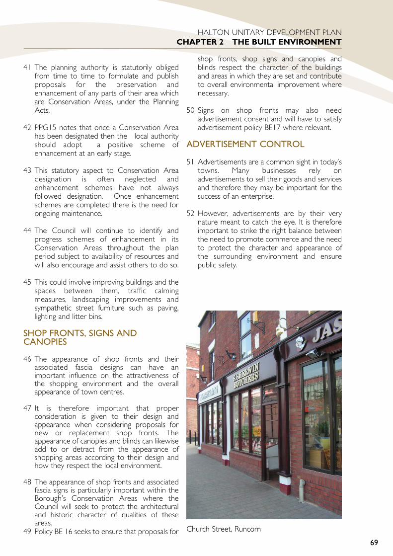
41 The planning authority is statutorily obligedfrom time to time to formulate and publishproposals for the preservation andenhancement of any parts of their area whichare Conservation Areas, under the PlanningActs.
42 PPG15 notes that once a Conservation Areahas been designated then the local authorityshould adopt a positive scheme ofenhancement at an early stage.
43 This statutory aspect to Conservation Areadesignation is often neglected andenhancement schemes have not alwaysfollowed designation. Once enhancementschemes are completed there is the need forongoing maintenance.
44 The Council will continue to identify andprogress schemes of enhancement in itsConservation Areas throughout the planperiod subject to availability of resources andwill also encourage and assist others to do so.
45 This could involve improving buildings and thespaces between them, traffic calmingmeasures, landscaping improvements andsympathetic street furniture such as paving,lighting and litter bins.
SHOP FRONTS, SIGNS ANDCANOPIES
46 The appearance of shop fronts and theirassociated fascia designs can have animportant influence on the attractiveness ofthe shopping environment and the overallappearance of town centres.
47 It is therefore important that properconsideration is given to their design andappearance when considering proposals fornew or replacement shop fronts. Theappearance of canopies and blinds can likewiseadd to or detract from the appearance ofshopping areas according to their design andhow they respect the local environment.
48 The appearance of shop fronts and associatedfascia signs is particularly important within theBorough’s Conservation Areas where theCouncil will seek to protect the architecturaland historic character of qualities of theseareas.
49 Policy BE 16 seeks to ensure that proposals for
shop fronts, shop signs and canopies andblinds respect the character of the buildingsand areas in which they are set and contributeto overall environmental improvement wherenecessary.
50 Signs on shop fronts may also needadvertisement consent and will have to satisfyadvertisement policy BE17 where relevant.
ADVERTISEMENT CONTROL
51 Advertisements are a common sight in today’stowns. Many businesses rely onadvertisements to sell their goods and servicesand therefore they may be important for thesuccess of an enterprise.
52 However, advertisements are by their verynature meant to catch the eye. It is thereforeimportant to strike the right balance betweenthe need to promote commerce and the needto protect the character and appearance ofthe surrounding environment and ensurepublic safety.
69
HALTON UNITARY DEVELOPMENT PLANCHAPTER 2 THE BUILT ENVIRONMENT
Church Street, Runcorn
ACCESS FOR ALL
53 Good planning and design of developmentshould help create a more accessibleenvironment for all people. Good accessshould be provided into, between, and aroundall buildings whether they be places of work,shops, public buildings, community facilities orother places to which the public have accesswhether as workers, visitors or customers.
54 The provision of facilities, access and parkingparticularly for people with restricted mobility,should be designed into a development at anearly stage. Design ‘added on’ at the lastminute is rarely as effective and can be muchmore costly.
55 Ensuring adequate access for people withdisabilities in developments is a responsibilityunder two main professional areas within theCouncil:
building control
planning
The respective roles and responsibilities aresummarised below.
ROLE OF BUILDING CONTROL:
56 Building Control controls access within newbuildings, covering issues such as internal layoutand circulation and the location and detaileddesign of such things as ramps, stairs, doors andsanitary conveniences. The Local PlanningAuthority has no control over these issues.
ROLE OF PLANNING:
57 Ensuring that people have adequate access tonew buildings is a material consideration andmust be taken into account in determiningplanning applications.
58 Planning can seek to ensure that considerationis given to the provision of adequate access fordisabled people in the preparation of sitelayouts and in the relationship betweenbuildings and their car parking areas and otherpublic access points. Planning can also seek toensure suitably designed and located disabledparking provision and adequate sign-posting.
NEED FOR JOINT WORKING:
59 There is a degree of overlap in theresponsibilities; of building control andplanning staff in ensuring reasonable provisionfor disabled access. It is therefore importantthat a co-ordinated approach is taken.
60 The Council will therefore encouragedevelopers to contact planning and buildingcontrol staff at an early stage to agreeacceptable provision.
TELECOMMUNICATIONS
61 The Government’s planning policy ontelecommunications is set out in PlanningPolicy Guidance Note 8(Telecommunications) as revised. It notes thatmodern telecommunications are an essentialand beneficial element in the life of the localcommunity and the national economy andthat modern, reliable communications canattract business to an area, help firms remaincompetitive and benefit the environmentthrough reducing the need to travel. For thesereasons the Government wishes to facilitatethe growth of new and existing systems.
62 PPG8 also notes that the Government is firmlycommitted to environmental objectivesincluding well established national policies forthe protection of the countryside and urbanareas. It notes that planning authorities shouldconsider the wider environmental impact oftelecommunications development and takeaccount of the advice on the protection ofurban and rural areas in other planning policyguidance notes with particular mention givento SSSI’s, the Green Belt and areas or buildingsof architectural or historic importance.
63 Policy BE 21 reflect this dual commitmentto encouraging the growth oftelecommunications whilst seeking to protectthe environmental quality and amenity of theBorough’s urban and rural areas.
70
HALTON UNITARY DEVELOPMENT PLANCHAPTER 2 THE BUILT ENVIRONMENT

PART 2 POLICIES ANDPROPOSALSPROMOTING A QUALITYBUILT ENVIRONMENTBE 1 GENERAL REQUIREMENTSFOR DEVELOPMENT
1 Development will be permittedprovided that the following criteria aresatisfied, where appropriate:
2 ENVIRONMENTAL QUALITY
a It must be of a high quality ofdesign that respects or wherenecessary creates localdistinctiveness.
b It must contain proposals for acarefully designed landscapescheme that reflects the essentialcharacter of the area and the use ofthe new buildings.
c It must avoid unacceptable loss ofamenity to occupiers or users ofadjacent land or buildings, by virtueof, noise disturbance, noxiousfumes, and dust or trafficgeneration. Adjacent residentialuses should not suffer unacceptableloss of amenity throughoverlooking, overshadowing oroverbearing appearance.
d It must be compatible with existingand proposed surrounding uses.
e It must be designed in such a waythat minimises the fear and risk ofcrime.
f It must not cause unacceptablelevels of pollution or nuisance.
3 ACCESSIBILITY
a Proposals for the design and layoutof roads, footpaths, accesses andservicing areas must comply withthe Council’s standards.
b It must make adequate provisionfor, and be easily accessible by,pedestrians (including those withrestricted mobility), cyclists, publictransport and should have easyaccess to the existing rail networkwherever possible in compliancewith the Council’s standards.
c It must not overload the capacity ofthe surrounding highway networknor be detrimental to highwaysafety.
d New buildings where the public willhave access must have adequateprovision for people withdisabilities or restricted mobility,particularly in terms of signage,access, facilities and car parking.
e It must not prejudice access ontothe identified Greenway Network,and where appropriate, shouldimprove or enhance greenwaylinkages.
4 CONSERVATION OF THE NATURALAND HISTORIC ENVIRONMENT
a It must ensure the retention,conservation, enhancement andintegration of sites and features ofparticular historic, archaeological,landscape, ecological or amenityvalue.
b It must ensure the retention,conservation, enhancement andintegration of features within andadjoining the site if they haveintrinsic value or make a valuablecontribution to the character oramenity of the site or surroundingarea.
c It must not result in theunacceptable loss of designatedgreenspace or other importantamenity open space.
d It must not use the best and mostversatile agricultural land grades1,2, and 3a, and if any agriculturalland is used the impact onagricultural viability and
71
HALTON UNITARY DEVELOPMENT PLANCHAPTER 2 THE BUILT ENVIRONMENT
BE1
productivity should be minimised.
5 INFRASTRUCTURE
a It must include adequate provisionfor any necessary improvements toutilities and services resulting fromthe development. It must not resultin unacceptable public expenditureto secure necessary improvementsin infrastructure.
b It must meet the Council’s on sitedrainage requirements and wherethere are off-site drainageproblems this must be dealt with tothe Council’s satisfaction.
6 MANAGEMENT OF RESOURCES
a It must not prejudice the planneddevelopment of a larger site or areafor which comprehensive proposalshave been approved or are inpreparation.
b It must take in to account the needfor energy efficiency by means ofbuilding orientation, site layout andby use of passive and active energysaving designs.
c It must maximise the use ofrecycled materials within thedevelopment.
d It must minimise the amount ofwaste produced duringconstruction and subsequentoperation of the development.
e It must ensure that adequate on-site provision is made for wastestorage and collection, in a suitablyenclosed and screened area.
f It must promote means to reducethe demand for water, by makingthe best use of current resource.
g It must take into account the needand potential for sustainabledrainage techniques.
JUSTIFICATION
7 This policy acts as a checklist of the maincriteria to be taken into account whendetermining the acceptability of developmentproposals.
ENVIRONMENTAL QUALITY
8 The enhancement of the built environment isa primary aim of the Plan. This in turn has aninfluence on other objectives of the Plan suchas promoting economic prosperity and urbanregeneration. Ensuring that development is ofa high standard of design is a means ofachieving these objectives.
9 Promoting local distinctiveness is a furtherobjective of the Plan, which is given support inPPG 1, paragraph 18. Local distinctiveness canbe described as “the sum of points ofconnection between the place and theperson” or about “the unique quality of placesand their particular cultures”. To respect localdistinctiveness, the design of newdevelopment proposals need to acknowledgethe unique character and appearance of aplace or locality. Generating localdistinctiveness in areas where it is consideredappropriate may be achieved through originaland innovative design that would add strongeridentity to those areas.
10 The Council will seek particularly highstandards of design from development locatedin an Environmental Priority Area (See policyBE 3) or other high profile or sensitivelocations.
11 In determining whether a developmentproposal is of a high quality design thatmaintains or enhances the character andappearance of the surrounding area theCouncil will have regard to the urban designprinciples set out in policy BE 2 Quality ofDesign.
12 The quality of the built environment can begreatly enhanced by considered site planningand the integrated use of hard and softlandscape treatments. Landscape design needsto be fully considered at an early stage in thedesign process in relation to the arrangementof space together with the use, access, andsafety and circulation factors as well as theoverall location of the development. It will
72
HALTON UNITARY DEVELOPMENT PLANCHAPTER 2 THE BUILT ENVIRONMENT

generally be required that landscape schemesare submitted to the Council with a reservedmatters application.
13 A generic landscape scheme (as part of anyproposed development) should include thefollowing information, in the form of text anddrawings at an appropriate scale:
Landscape Survey: an accurate recordof all existing landscape features on thesite, including (as appropriate): landform;hard landscape features; trees, shrubs,hedges and other vegetation; otherhabitats which are of importance towildlife; water bodies and water courses;important views into and out of the site;and physical and visual links with adjoininglandscapes.
Protection of landscape features tobe retained: details of how suchlandscape features will be protectedduring construction.
Design details: explaining the designphilosophy and concepts, and showing thelayout of the landscape proposals, andhow they relate to the proposeddevelopment and the adjoining landscape.
Hard Landscape Proposals: details ofboundary structures, hard surfacing,drainage, lighting, play equipment, sitefurniture etc, including information onheight and materials, and an outlinespecification for installation.
Soft Landscape Proposals: details ofplanting, seed mixes etc, including sizes,planting densities, and an outlinespecification for ground preparation,planting, seeding, aftercare, etc.
14 The Council is committed to improving thequality of life of its residents and workers andas such development needs to respectadjoining users, particularly residents.Development needs to be appropriately sitedso that unacceptable nuisance or loss ofamenity to adjoining users is avoided.
15 The design and layout of development candirectly reduce opportunities for crime such astheft, assault and burglary, as well as reducingthe fear of crime. Development can be
designed and laid out to provide for thesurveillance of open spaces, houses can be setout so that the main living areas look out overthe access and adequate lighting can providefor surveillance at night. The relationshipbetween buildings, and between buildings andspaces, can influence the sense of communityfelt by inhabitants that in turn can increase thedegree of neighbourly concern for adjoiningresidents and property. Designing againstcrime aims to reassure the public by makingcrime more difficult to commit, increasing therisk of detection and providing people with asafer and more secure environment. Adviceon the issue is given in Circular 5/94 PlanningOut Crime. The local Police ArchitecturalLiaison Officer may be consulted in relation toproposed developments.
ACCESSIBILITY
16 Concentration of development close toexisting urban centres provides the bestopportunity to reduce the need to travel,encourage increasing use of public transport,cycling and walking and mitigate the widerenvironmental damage brought about bydependence on the private car. Developmentshould be sited where it can contribute tominimising travel demand and where thepotential for walking and cycling is optimisedor where public transport systems can serve iteffectively. Providing accessibility for all peoplemeans planning for people with disabilities andrestricted mobility.
17 The Council is committed to the developmentof a network of largely car free off road routesin the Borough, that will connect people withfacilities and greenspaces within the urban areaand to the countryside. Development will notbe permitted if it would prejudice thisobjective. However appropriate developmentwill be required to consider measures toimprove the Greenway Network .
CONSERVATION OF THE NATURALAND HISTORIC ENVIRONMENT
18 Conservation of the Borough’s wildlife,landscape, productive farmland, historic andarchaeological features, trees, woodlands,hedgerows and open spaces is an essentialelement of sustainability and serves tomaintain the quality of life for the Borough’sresidents and employees.
73
HALTON UNITARY DEVELOPMENT PLANCHAPTER 2 THE BUILT ENVIRONMENT

19 In the natural and built environments, thereare some irreplaceable assets that can not berecreated or relocated. These include habitatssuch as ancient woodlands, important treesand hedgerows, significant historic buildingsand monuments. The Council aims to protectall such critical assets from inappropriatedevelopment that could irreparably harm theirlocation or setting. In addition there are manyfeatures that do not have protected statusthat nevertheless make a valuable contributionto the character of a site or locality that shouldbe retained and conserved in the interests offostering local distinctiveness. For instance onlya small proportion of significant trees arecurrently protected by Tree PreservationOrders, Conservation Areas or felling licencerequirements. Most trees are not protectedbut this does not necessarily mean that theyare of lesser value to the environment, onlythat their status has not been formallyrecognised to date. Whatever the feature it isimportant to ensure that it is properlyintegrated into the development to prevent itbecoming an isolated or dysfunctional elementof the development.
20 To identify critical assets in and adjoining thesite and to include features that have intrinsicvalue or make a valuable contribution to thecharacter of the site and its surroundings, theCouncil will encourage applicants to undertakeproper site planning and land survey workprior to the formulation of a developmentlayout. For instance an arboricultural surveyundertaken at an early stage in the designprocess, in accordance with British Standard5837;1991 will identify trees that are essentialor desirable to retain, as individuals or groups.This type of survey information shouldinfluence the proposed layout of thedevelopment and the methods of protectionneeded to be to enable the trees to beretained in a good condition.
21 The Unitary Development Plan (UDP) seeksto ensure adequate provision of greenspacesin the Borough in terms of quantity, quality anddistribution. There is a presumption againstthe loss of greenspace in recognition of theimportant role it plays in the improving thequality of life of residents. There are, however,limited circumstances where loss ofgreenspace will be permitted and this is setout in policy GE 6.
22 The Plan also seeks to protect the mostproductive farmland which if built upon will belost forever. Quality agricultural land is a scareresource and needs to be protected for futuregenerations.
INFRASTRUCTURE
23 New development can generate additionaldemand for utilities and services. To ensurethat development is properly integrated intothe existing infrastructure provision, theCouncil’s requirements for services should bemet and an appropriate contribution to thecost of such services will be sought from thedevelopment.
24 Discussions with United Utilities and theEnvironment Agency will be necessary toensure water infrastructure is or will be inplace to serve development proposals. Whereimprovements are planned or need to bemade development will be phased accordingly.This will be to ensure proposals have beenassessed regarding their suitability in terms ofbeing served by an adequate means of watersupply and foul drainage systems are notoverloaded or contribute to or cause furtheramenity or water pollution problems.
MANAGEMENT OF RESOURCES
25 Efficient management of the environment andresources is a fundamental aspect ofsustainability. Land is a scare resource requiringappropriate management of its use. As such,development proposals that conflict with plansor proposals for a comprehensive approach toland use planning of an area or a large site willbe refused.
26 The commitment to controlling climatechange through the reduction in global and UKgreenhouse gas emissions, to below existinglevels, is likely to require the following:
Significant changes in energy production;
The cutting of road traffic emissionthrough fuel efficiency and reducing theneed to travel by car;
Improvements in energy efficiency ofindustrial processes, homes, & offices.
27 As such development must demonstrate how74
HALTON UNITARY DEVELOPMENT PLANCHAPTER 2 THE BUILT ENVIRONMENT

energy efficiency has been considered in theoverall design.
28 All development proposals will generatewaste, both in the development process andwhen in subsequent use. As part ofencouraging sustainable waste management,the Council will wish to ensure that alldevelopment proposals illustrate how this hasbeen addressed. This can be done bymaximising the use of recycled materials in thedevelopment, and by designing developmentsso that the amount of waste generated by thedevelopment itself is minimised. Oncecompleted and operational, the Council willwish to see developments which operateeffectively in terms of on-site wastemanagement, ensuring that waste arisings aresecurely and tidily housed within the site priorto collection. This can have wider benefits interms of reducing litter generation, and canalso reduce the incidence of crime andvandalism.
MATTERS INFLUENCINGOVERALL DESIGN
BE2 QUALITY OF DESIGN
1 The quality of design of a developmentproposal will be assessed byconsidering it against the followingmatters that influence overall design:
Layout;
Density;
Scale;
Massing;
Height;
Materials;
Landscape;
Access;
Accessibility;
Public realm issues e.g. open space,squares etc.;
Topography and site levels;
Local distinctiveness & character;
Energy conservation.
2 In considering a development proposalagainst the above matters particularregard will be had to the followingguiding principles. Development shouldbe designed to:
a Respect and utilise any positivecharacteristics of the site.
b Respect and relate well to existingadjacent buildings and features oftownscape value.
c Optimise the relationship andintegration of buildings, and thesurrounding hard and softlandscape.
d Respect the nature and characterof the surrounding area includingits established arrangement andalignment of streets, buildingfrontages, any architectural orhistorical characteristics, otherstructures and landscape featuresand their interrelationship.
e Create visual interest, particularlyat street level, by attention todetailing such as decoration,pattern, use of colour andmaterials, lighting and landscaping.
f Provide an attractive built frontagewith quality facing materials if it iseasily visible from a road, footpath,open space, canal or railway.
g Maintain and protect views whichare important to the character andvisual amenities of the area.
h Be of a height, massing, density andlayout that respects human scale.
3 Development should also take thefollowing factors into account:
a Original and innovativearchitecture will be encouragedprovided that it respects thecharacter and appearance of itssetting.
75
HALTON UNITARY DEVELOPMENT PLANCHAPTER 2 THE BUILT ENVIRONMENT
BE2

b Developments which create alandmark or focal point will beacceptable where they will createan attractive ‘reference point’ orhelp to create identity in an arealacking character or attractiveness.
c Where the existing area has littlecharacter or clear form thendevelopment should be designed togive a stronger identity to thatarea; developments of more thanone building should have a co-ordinated overall design withconsideration given to properprovision of access into andbetween the various elements ofthe scheme.
d The provision of public art and theintegration of art and craftworkinto the design of the developmentscheme.
External Appearance and Style
4 Planning permission will not begranted for development that wouldhave an unacceptable effect on thecharacter of the surrounding areabecause of its external appearance andstyle.
JUSTIFICATION
5 This policy aims to ensure that developmentproposals properly consider the importantissues of design which influence design quality.A development of high design quality shouldbe both functionally efficient and visuallyattractive. These requirements are closelyinterrelated.
6 Applicants are encouraged to liase with theplanning authority prior to the submission of aplanning application to discuss design mattersat an early stage before schemes are firmedup. An important aim of the Council is to assistthe applicant in progressing developmentproposals in a successful manner.
7 PPG 1 Annex A paragraph A4 emphasises theimportance of applicants being able to showhow their development proposals have takenaccount of the need for good design. As suchall development proposals other than straight
forward or small scale proposals not involvingsensitive sites will be required to submit adesign statement along with illustrativedrawings showing the plan and elevationdetails, photographs of the site and itssurroundings and perspective views of thescheme. The design statement should refer toall the matters listed in point one of the policy.
8 If it is proposed to change existing site levelsthen information on the volume and type ofmaterials to be brought onto or removedfrom the site will also be required.
9 Incorporating public art into a developmentcan not only raise the overall design quality ofdevelopment, it can also raise its profile, bycreating a focal point of interest. It can alsoraise the overall quality of the localenvironment, by making it more attractive andinteresting. The Council will actively encouragedevelopers to spend a percentage of the totaldevelopment costs or a fixed amount ofmoney on providing art and craftwork and onseeking the influence of artists and crafts skillsalongside architects and building professionals,to ensure integration of art and craftworkfeatures as an essential part of the design. TheCouncil is currently producing a Public ArtStrategy that will provide additional guidanceand advice for developers.
ENHANCING THE LOCALENVIRONMENT
BE3 ENVIRONMENTALPRIORITY AREAS
1 Within the Environmental PriorityAreas the Council will pay particularregard to significantly raisingenvironmental standards:
a Proposals for development will beexpected to be of a quality of designthat enhances the character andappearance of that area.
b Development adjacent to or visiblefrom the main road and railtransport routes should be of a highquality of design in terms oflandscaping, boundary treatmentsand facing materials.
76
HALTON UNITARY DEVELOPMENT PLANCHAPTER 2 THE BUILT ENVIRONMENT
BE3
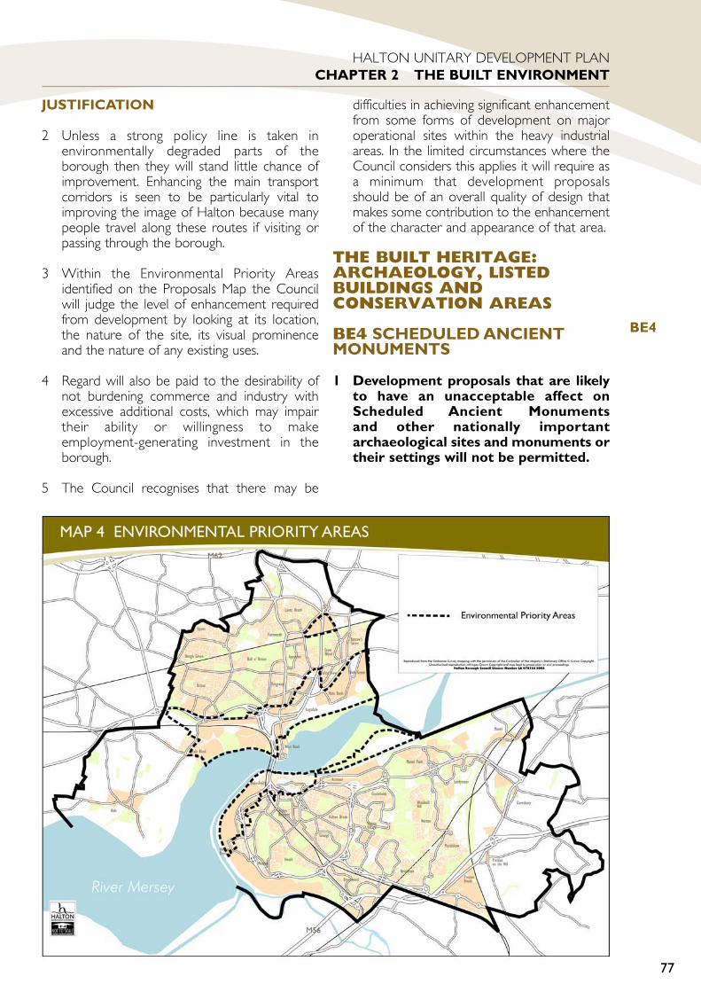
JUSTIFICATION
2 Unless a strong policy line is taken inenvironmentally degraded parts of theborough then they will stand little chance ofimprovement. Enhancing the main transportcorridors is seen to be particularly vital toimproving the image of Halton because manypeople travel along these routes if visiting orpassing through the borough.
3 Within the Environmental Priority Areasidentified on the Proposals Map the Councilwill judge the level of enhancement requiredfrom development by looking at its location,the nature of the site, its visual prominenceand the nature of any existing uses.
4 Regard will also be paid to the desirability ofnot burdening commerce and industry withexcessive additional costs, which may impairtheir ability or willingness to makeemployment-generating investment in theborough.
5 The Council recognises that there may be
difficulties in achieving significant enhancementfrom some forms of development on majoroperational sites within the heavy industrialareas. In the limited circumstances where theCouncil considers this applies it will require asa minimum that development proposalsshould be of an overall quality of design thatmakes some contribution to the enhancementof the character and appearance of that area.
THE BUILT HERITAGE:ARCHAEOLOGY, LISTEDBUILDINGS ANDCONSERVATION AREAS
BE4 SCHEDULED ANCIENTMONUMENTS
1 Development proposals that are likelyto have an unacceptable affect onScheduled Ancient Monumentsand other nationally importantarchaeological sites and monuments ortheir settings will not be permitted.
77
HALTON UNITARY DEVELOPMENT PLANCHAPTER 2 THE BUILT ENVIRONMENT
BE4

JUSTIFICATION
2 The Secretary of State compiles and maintainsthe Schedule of Ancient Monuments; themonuments on the Schedule are of nationalimportance and have statutory protection. Itshould be noted that not all nationallyimportant remains meriting preservation willnecessarily be scheduled.
3 Scheduled Ancient Monuments in Halton arelisted as follows:
Duck decoy pond 200m SE of MarshBridge, Hale
Halton Castle: a ruined keep castle on thesite of an earlier motte and bailey
Augustinian Abbey known as NortonPriory, Halton
Standing cross in St Luke’s churchyard,Farnworth, beside the south porch,Halton
Lovel’s Hall moated site and fishpond,Widnes
New Manor Farm moated site, PrestonBrook
Cranshaw Hall moated site, Widnes
4 Scheduled Ancient Monuments and otherarchaeological remains contain irreplaceableinformation about our past. They are a part ofthe national and local heritage and culture.They are valuable for their own sake and fortheir role in education, leisure and tourism. Insustainability terms they are to be regarded asinviolable or critical assets.
BE5 OTHER SITES OFARCHAEOLOGICALIMPORTANCE
1 Development proposals that are likelyto have an unacceptable affect onother known sites and monuments ofarchaeological significance will not bepermitted. Permission may be grantedif it can be demonstrated thatmeasures of mitigation (such aspreservation by design or record) andcompensation (such as advances inknowledge or public understanding)
can be employed to ensure there is nonet loss of heritage or archaeologicalvalue.
JUSTIFICATION
2 Cheshire County Council maintains the localSites and Monuments Record (SMR) on behalfof the Council. This provides information ofarchaeological remains, where they are knownor thought likely to exist. The record includesarchaeological sites that do not qualify fornational statutory scheduling, but are ofsufficient regional or local importance to meritprotection.
3 In sustainability terms such sites may in somecircumstances be regarded as tradable assets:preservation of the asset in situ is highlydesirable, but where this is impossible toachieve, planning permission will only begranted subject to agreement on satisfactoryrange of measures of mitigation andcompensation which will ensure that there isno overall net loss of heritage orarchaeological value resulting from thedevelopment.
BE6 ARCHAEOLOGICALEVALUATIONS
1 Where development proposals affectsites of known or suspectedarchaeological importance the Councilmay require the applicant to submit anarchaeological evaluation prior tothe determination of the planningapplication. This information will beused to assess the archaeologicalimpact of development proposals.
JUSTIFICATION
2 The prime archaeological objective is thepreservation in situ of important remains Thiscan often he achieved by such methods asdesign modification and by landscaping insensitive areas. It is therefore important toobtain a detailed picture of the archaeology ofthe area of interest, in order that constraintsto development can be identified and that,where appropriate, measures of mitigation andcompensation can be developed.
78
HALTON UNITARY DEVELOPMENT PLANCHAPTER 2 THE BUILT ENVIRONMENT
BE5
BE6

BE7 DEMOLITION OF LISTEDBUILDINGS
1 Consent for demolition of listedbuildings will not be granted otherthan in the most exceptionalcircumstances and only when thePlanning Authority is satisfied thatevery possible effort has been made tocontinue the present use or find asuitable alternative use and suchefforts have failed or substantialcommunity benefit would ensue thatdecisively outweighed the loss of thebuilding.
2 Consent for demolition of a listedbuilding will be conditional on it notbeing demolished until:
a A suitable programme of recordingfeatures, which are sheduled to bedestroyed, is undertaken whereappropriate;
and
b Detailed planning permission forthe redevelopment of the site hasbeen obtained and there is firmevidence that a contract has beenlet for the redevelopment;
or
c A landscaping and improvementscheme is submitted to thesatisfaction of the planningauthority, plus an agreement tomaintain it, if the site is being keptin open space use;
and
d A demolition notice under section81 of The Building Act 1984 hasbeen served.
JUSTIFICATION
3 Listed Buildings are of recognised architecturalor historic interest and their loss throughdemolition would generally be detrimental tothe character and appearance of thesurrounding area and to the overall heritage ofthe borough. Demolition will therefore onlybe permitted in the most exceptional
circumstances and only if this is the last feasibleoption.
4 Sometimes the site of a demolished buildingwould be better kept in open space use,whether public or private, for townscapereasons. This situation is permitted for subjectto a suitable scheme being agreed with theplanning authority.
BE8 CHANGES OF USE OFLISTED BUILDINGS
1 There will be a general presumption infavour of retaining listed buildings forthe use for which they were originallydesigned and intended for.
2 The Council will give favourableconsideration to proposals foralternative uses for listed buildingsonly in the following circumstances:
a If continuation of the original use isnot a practical proposition and anew use is necessary to ensure thelong term survival of the building;
or
b If the listed building is no longer inits original use and the proposedchange of use would be more inkeeping with protecting orreinstating the originalarchitectural and historic characterof the building.
3 If a proposal meets the circumstancesoutlined above then a change of usewill be permitted unless:
a It would have a detrimental effecton the appearance or thearchitectural and historiccharacter of the building;
or
b It would detract from thecharacter and setting of thesurrounding area by way of noise,traffic generation or otherrelevant planning considerations.
79
HALTON UNITARY DEVELOPMENT PLANCHAPTER 2 THE BUILT ENVIRONMENT
BE8
BE7

JUSTIFICATION
4 The best way of preserving the character andappearance of buildings of architectural orhistoric importance would normally be tokeep them in their original use.
5 Some listed buildings are no longer requiredfor their original use and there is a danger thatthey could lie empty and fall into disrepair,causing on eyesore and increasing pressure forthem to be demolished.
6 Therefore the Planning Authority needs to beflexible in considering new uses for suchbuildings if a new use holds the key to abuilding’s preservation.
7 For such a change of use to be acceptable itshould maintain the integrity of the building interms of its appearance and character. Thiswould involve retaining such things as theoriginal interior layout and importantarchitectural features.
BE9 ALTERATIONS ANDADDITIONS TO LISTEDBUILDINGS
1 In the determination of an applicationfor planning permission or listedbuilding consent to alter, internally orexternally, or to extend, a listedbuilding or a structure within itscurtilage, the predominantconsideration will be the preservationof the special architectural or historicfeatures and character of the buildingor structure. Consent will not begranted unless it is shown that theproposed works will best serve thatend.
2 Proposals to alter or extend a listedbuilding should comply with all of thefollowing criteria:
a Extensions must respect thecharacter and scale of the originalbuilding and not be allowed todominate.
b The replacement of doors, windowsand other features in non-traditional materials will not bepermitted.
c Attention should be paid to theretention of the original plan form,roof construction and interiorfeatures of merit, as well as theexterior of listed buildings.
d Extensions must as far as possiblebe built of materials matchingthose of the original building.
JUSTIFICATION
3 All alterations and additions should notunacceptably affect the essential character ofthe building, should be in keeping with itsarchitectural style and features and shouldharmonise with its surroundings.
4 In particular such development will have to beof a high standard of design and externalappearance and materials will be expected tomatch, as near as possible, those of theexisting buildings in kind and in detail.
5 In assessing proposals involving the alterationsof a listed building the Council will refer to theadvice contained in Annex C of PPG 15.
BE10 PROTECTING THESETTING OF LISTED BUILDINGS
1 Development which would affect thesetting of a listed building should aimto preserve both the character of thatsetting and its historic relationship tothe listed building. This will include,where appropriate, the preservation oftrees and other landscape features.
JUSTIFICATION
2 PPG 15 recognises that the setting of abuilding of special architectural or historicinterest is often an essential feature of itscharacter. The setting could be its garden,grounds, open space or the generalstreetscene.
3 It is therefore essential to consider the impactof development and other proposals withinthe vicinity of listed buildings. Close controlover the “quality of design” of development inclose proximity to a listed building will theessential to protect its setting. Conditions mayneed to be imposed on such development toachieve the quality required.
80
HALTON UNITARY DEVELOPMENT PLANCHAPTER 2 THE BUILT ENVIRONMENT
BE9
BE10

BE11 ENABLINGDEVELOPMENT AND THECONSERVATION OF HERITAGEASSETS
1 Proposals for enabling developmentwill only be permitted if all thefollowing criteria are met:
a The enabling development will notmaterially detract from thearchaeological, architectural,historic or landscape interest of theasset, or materially harm itssetting.
b The proposal will not result in themanagement of the heritage assetbeing broken up in a manner whichwould be detrimental to its propermanagement.
c The enabling development willsecure the long term future of theheritage asset and, whereapplicable, its continued use for asympathetic purpose.
d The need for the enablingdevelopment arises from theinherent needs of the heritageasset, rather than thecircumstances of the present owneror the purchase price paid.
e Financial assistance is not availablefrom any other source.
f It is demonstrated that theamount of enabling development isthe minimum necessary to securethe future of the heritage asset andthat its form minimises disbenefits.
g The value of the survival orenhancement of the heritage assetoutweighs the long term cost tothe community (i.e. the disbenefits)of providing the enablingdevelopment.
JUSTIFICATION
2 Many proposals affect heritage assets. Mostenhance, or are not materially damaging to,the building or its setting. Creative adaptation
and development is often vital to securing thefuture of listed buildings. On occasion,however, “enabling development” is proposedwhich, whilst achieving benefit to the listedbuilding, particularly one “at risk”, is contrary toother objectives of national, regional, or localplanning policy. Such proposals are putforward on the basis that the benefit to thecommunity of conserving the building wouldoutweigh the harm to other material interests.Enabling development is an established anduseful planning tool by which a communitymay be able to secure the future of a heritageasset provided it is satisfied that the balance ofpublic advantage lies in permitting the enablingdevelopment.
3 The Council will only accept a full planningapplication to ensure that the impact of theproposal is precisely defined at the outset.Furthermore the use of conditions andplanning obligations will be used toenforceably link the restorative programme tothe enabling development.
BE12 GENERAL DEVELOPMENTCRITERIA - CONSERVATIONAREAS
1 Development affecting a ConservationArea will only be permitted if it willpreserve or enhance the specialarchitectural or historical characterand appearance of that area.
2 Regard will be made to the followingcriteria in determining applications fordevelopment, including new build,alterations, extensions and changes ofuse, as appropriate:
a. It should be of a high standardof design which respects theappearance and character of theConservation Area in terms of itsbulk, height, mass, vertical andhorizontal emphasis, proportions,materials, colour, layout, siting,landscaping and other matters ofdetailed design such as roofscapeand architectural style anddetailing.
b It should harmonise with adjoiningbuildings, enhance the streetsceneand should not detract from
81
HALTON UNITARY DEVELOPMENT PLANCHAPTER 2 THE BUILT ENVIRONMENT
BE11
BE12
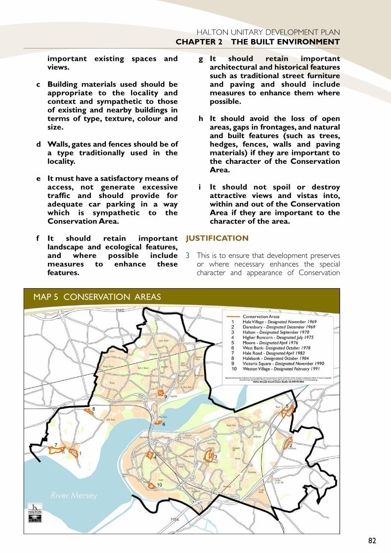
important existing spaces andviews.
c Building materials used should beappropriate to the locality andcontext and sympathetic to thoseof existing and nearby buildings interms of type, texture, colour andsize.
d Walls, gates and fences should be ofa type traditionally used in thelocality.
e It must have a satisfactory means ofaccess, not generate excessivetraffic and should provide foradequate car parking in a waywhich is sympathetic to theConservation Area.
f It should retain importantlandscape and ecological features,and where possible includemeasures to enhance thesefeatures.
g It should retain importantarchitectural and historical featuressuch as traditional street furnitureand paving and should includemeasures to enhance them wherepossible.
h It should avoid the loss of openareas, gaps in frontages, and naturaland built features (such as trees,hedges, fences, walls and pavingmaterials) if they are important tothe character of the ConservationArea.
i It should not spoil or destroyattractive views and vistas into,within and out of the ConservationArea if they are important to thecharacter of the area.
JUSTIFICATION
3 This is to ensure that development preservesor where necessary enhances the specialcharacter and appearance of Conservation
82
HALTON UNITARY DEVELOPMENT PLANCHAPTER 2 THE BUILT ENVIRONMENT

Areas in accordance with Planning PolicyGuidance Note 15 (Planning and the HistoricEnvironment).
BE13 DEMOLITION INCONSERVATION AREAS
1 Demolition of buildings or structureswill only be permitted if they do notcontribute to the character orappearance of a Conservation Area.
2 Consent for demolition of a building orstructure within a Conservation Areawill only be granted if one or more ofthe following circumstances apply:
a It is proved to be wholly beyondeconomic repair.
b It is incapable of reasonablebeneficial use.
c It is not of intrinsic architectural,historic or townscape importanceand its removal or replacementwould enhance the appearance orcharacter of the area;
d Its removal would allow theredevelopment or rehabilitation ofan adjacent larger site which isunderused, neglected or derelict ifthis would enhance the characterand appearance of theConservation Area.
3 Consent for demolition of a buildingwill be conditional on it not beingdemolished until either:
a Detailed planning permission forthe redevelopment of the site hasbeen obtained and there is firmevidence that a contract hasbeen let for the redevelopment;
or
b A landscaping and improvementscheme is submitted to thesatisfaction of the planningauthority, plus an agreement tomaintain it, if the site is being keptin open space use.
and
c A demolition notice under section81 of The Building Act 1984 hasbeen served.
JUSTIFICATION
4 Consent from the Council is needed for mosttypes of demolition in a Conservation Area. Ifthe building is still economically viable orimportant to the area’s character thendemolition will be resisted.
5 If the Council approves the demolition of abuilding in a Conservation Area it will ensurethat unsightly gaps and dereliction are notcreated by requiring that either developmentof a high quality will replace it or the site isimproved to create an attractive open spaceof townscape value.
BE14 OUTLINE APPLICATIONS- CONSERVATION AREAS
1 Outline applications for developmentwithin Conservation Areas will only beconsidered if illustrative plans andelevations are submitted showingimportant details of the proposeddevelopment.
2 These details should include the siting,design, external appearance, means ofaccess, landscaping, materials to beused and the overall scale of thedevelopment.These details should alsoshow how the proposed developmentfits into the context of its surroundings.
JUSTIFICATION
3 Outline applications do not generally provideenough information to determine whether adevelopment will protect and enhance thespecial historical and architectural characterand appearance of a Conservation Area.Additional information will therefore berequired as needed and applicants are stronglyadvised to submit full planning applications.
4 Applicants should enquire as to the Council’srequirements in respect of each developmentproposal in a Conservation Area beforesubmitting a formal planning application.
83
HALTON UNITARY DEVELOPMENT PLANCHAPTER 2 THE BUILT ENVIRONMENT
BE14
BE13

BE 15 LOCAL LIST OFBUILDINGS AND STRUCTURESOF ARCHITECTURAL ANDHISTORIC INTEREST
1 Development proposals that affect thecharacter of a building or structureincluded within Halton BoroughCouncil’s Local List of Buildings andStructures of Local Architectural orHistorical Interest, will be permittedprovided that the character of thebuilding or structure is maintained.
JUSTIFICATION
2 Many buildings and structures which do notqualify for listed status are valued as goodexamples of local architectural styles or fortheir local historical significance, and therebycontribute to the character of the locality.Such buildings will be included within a LocalList of Buildings and Structures of LocalArchitectural or Historical Interest producedby the Council as a Supplementary PlanningDocument. This will be a materialconsideration in dealing with planningapplications that directly affect the character ofbuildings on the list.
SHOP FRONTS, SIGNS ANDCANOPIES
BE16 ALTERATIONS TO ANDNEW SHOP FRONTSDesign
1 Proposals for new and altered shopfronts will be permitted provided thatall of the following criteria arecomplied with:
a Be appropriate to the building inwhich they are set in terms ofproportions, detailing andmaterials.
b Respect the context of the street orspace in which they are set.
c Accommodate the shop signage ina way that contributes to theoverall design.
Security
2 Proposals for shop front securitymeasures will be permitted providethat they are accommodated in anunobtrusive manner and do not includeany of the following:a The blanking out of windows.
b Projecting shutter boxes.
c Unperforated roller shutters.
d Galvanised finishes.
Access For Those With Special Needs
3 Proposals for new and altered shopfronts should make reasonable accessprovision for all people. Particularlythose with disabilities and restrictedmobility.
JUSTIFICATION
4 Given that the built environment in Halton isundergoing and in need of furtherimprovement, it is considered important toensure that, with regard to shop fronts,existing features of quality are retained andthat developments do not worsen thesituation. Particular attention will be given toensuring that architectural features areretained and that advertisements are in scalewith the buildings, are not unduly dominant,do not conflict with architectural features andare positioned so as to be seen as integralfeatures.
5 Whilst the Council acknowledge that the needfor security is often paramount to the retailer,the creation of “dead” frontages in towncentres and suburban areas can create adesolate and even threatening environment.The Council will therefore seek a balancebetween the security needs of the industryand the need to protect amenity. With regardto roller shutters, the steel link-mesh see-through style is preferred. Solid shutters maybe acceptable if properly integrated andprovided with a suitable decorative finish.
6 For those groups in society with special needsaccess to shopping facilities is an essentialaspect of daily life. The Council will thereforerequire designs to incorporate appropriate
84
HALTON UNITARY DEVELOPMENT PLANCHAPTER 2 THE BUILT ENVIRONMENT
BE16
BE15

measures, such as ramps, automatic doors,handrails, etc. to facilitate access.
7 It is acknowledged that, in certaincircumstances, such as small shop units, theprovision of ramps will simply not bepracticable. However, in most cases it shouldbe possible to widen doorways and lower stallrisers. Where automatic teller machines arebeing provided, at least one should be placedat the appropriate height for wheelchair users.Special care will need to be exercised inaccommodating improved access to shops if itis a Listed Building or within a ConservationArea.
8 Further guidance on shop fronts in Halton iscontained in Supplementary PlanningGuidance Shop Fronts and Signs.
ADVERTISEMENT CONTROL
BE17 ADVERTISING &ADVERTISEMENTS
1 In considering any application forAdvertisement Consent or enforcingthe discontinuance of a display afterthe specified period, if consideredreasonable, all of the following criteriawill be considered:
Amenity
a Advertisements should becompatible with the character oftheir surroundings, including thescale and detailing of any buildingagainst which they are seen, byreason of their size, siting, heightabove ground level, materials,colour and design.
b Free-standing displays should beintegrated with their surroundingsby appropriate design andlandscaping.
c Advertisements on buildings shouldappear as an integral and not adominant feature of the building.
d Advertisements should not conflictwith the character, appearance,architecture, setting or historicalmerits of Conservation Areas and
Listed Buildings.
e The advertisement should not leadto intrusive visual clutter.
f The advertisement should notprejudice the amenity of theoccupiers of nearby dwellings orother buildings, either by reason ofinappropriate design or means ofillumination.
g In the right locations, (and inparticular in relation to free-standing poster displays) whetheradvertisements can offer theopportunity to secure vitality andenvironmental benefits, byscreening eyesores andredevelopment sites or providing asolution to the use of marginal landleft by road works, albeit on atemporary basis whereappropriate.
Safety
h The effect of the advertisementupon highway safety, the safe useand operation of any form of trafficor transport, including the safety ofpedestrians.
i An advertisement should notimpede the visibility of road usersin the vicinity of junctions, accesses,bus stops and crossing points.
JUSTIFICATION
2 The Council recognises that advertising has auseful role to play in the commercial life ofthe Borough and the appearance of the builtenvironment.
3 On the other hand, excessive advertisingmaterial can create the wrong impression, interms of inward investment and thedetrimental effects on local amenity. Forsuch reasons, it is intended to actually usediscontinuance powers wherever appropriate.
4 Government Policy on advertisement controlis contained in PPG 19, which recognises thatthe only factors to be taken into account indetermining the acceptability of an
85
HALTON UNITARY DEVELOPMENT PLANCHAPTER 2 THE BUILT ENVIRONMENT
BE17
advertisement, are the interests of amenityand public safety. The policy is structured toreflect these two considerations.
5 The DTLR ‘Modernising Planning’Consultation Papers - OutdoorAdvertisement Control has been considered.
6 In some circumstances hoardings can make auseful contribution to improving theenvironment, for example by tidying vacantland in the short term with appropriatecomplementary landscaping. Poster displayswill normally be unacceptable in opencountryside and residential areas.
7 Free-standing signs can also in circumstances,be incorporated into other ‘decorative’ or ‘Art’features, and contribute to widerenvironmental incentives.
8 Further guidance on advertisement control inHalton is contained in Supplementary PlanningGuidance Shop Fronts and Signs.
ACCESS FOR ALL
BE18 ACCESS TO NEWBUILDINGS USED BY THEPUBLIC
1 Proposals for new buildings to whichthe public are likely to have access willbe permitted provided that it complieswith all of the following criteria:
a Provision of a suitable means ofaccess to the building, particularlyfor people with disabilities orrestricted mobility, which is wellsign-posted and easily accessedfrom adjoining streets, pedestrianroutes and car parks.
b Provision of car parking for disabledpeople and those with restrictedmobility, where appropriate, whichare conveniently located for ease ofaccess to the building.
c Provision of dropped kerbs andaccess ramps to facilitate ease ofaccess around the buildingespecially to parking provided to amobility standard and any mainopen spaces and recreational areas.
d Access into and around the outsideof buildings should be designed tominimise difficulties for partially-sighted and blind people.
2 Where a development proposalinvolves more than one building asuitable route between the buildingsfor people with disabilities andrestricted mobility will be required.
JUSTIFICATION
3 The Council is committed to ensuring betteraccess within the built environment for allsectors of the community, particularly peoplewith disabilities. Ensuring adequate access tonew buildings is an important means ofachieving this.
4 The Council is statutorily obliged to informdevelopers of their duty to have regard to BS5810 “Code of Practice for Access for theDisabled to Buildings” which sets down theminimum requirements needed to satisfy theprovisions of the Chronically Sick and DisabledPersons Act 1970.
5 Proper planning and provision for people withdisabilities will also help other people whomay have restricted mobility such as peoplewith prams and pushchairs and will thereforehelp to improve access for all.
6 Refer to Appendix 1 for Parking Standards.
BE19 DISABLED ACCESS FORCHANGES OF USE,ALTERATIONSAND EXTENSIONS
1 The alteration, change of use orextension of existing buildings towhich the public are likely to haveaccess,will only be permitted if suitableaccess is provided for disabled peopleand those with restricted mobility andwhere this is considered practicableand reasonable.
JUSTIFICATION
2 For alterations, extensions and changes of useto existing premises the Council will expectapplicants to make appropriate accessprovision for people with disabilities, unlessthe applicant can effectively demonstrate thatthis is neither practicable or reasonable.
86
HALTON UNITARY DEVELOPMENT PLANCHAPTER 2 THE BUILT ENVIRONMENT
BE19
BE18
3 The ability (or otherwise) to provide suitabledisabled access including parking or accessaround the site will be a material planningconsideration in determining the acceptabilityof the proposal.
4 Where disabled access is a requirement of adevelopment involving a listed building or abuilding within a Conservation Area theCouncil will also consider its impact on thebuilding’s character and appearance indetermining the acceptability of the proposal.
BE20 DISABLED ACCESS INPUBLIC PLACES
1 All development proposals mustprovide for ease of access andmovement for disabled people andthose with restricted mobililtybetween and within public areas by thecareful provision, siting and design ofparking areas, paths, dropped kerbs,pedestrian crossings, street furnitureand open space.
JUSTIFICATION
2 The Council wants to make public places asaccessible and safe as possible for all sectionsof the community whether able bodied ordisabled. This should be reflected in the designof the Council’s own schemes for public areas,covering access to open space,pedestrianisation proposals, parking schemes,and street furniture provision.
TELECOMMUNICATIONS
BE21 TELECOMMUNICATIONSAPPARATUS
1 Planning permission will be grantedfor telecommunications developmentsprovided that it complies with thefollowing criteria where appropriate:
a Wherever possible, non-domesticapparatus should not be sitedwithin residential areas.
b Wherever possible, masts andtowers should be shared andmounted apparatus shouldotherwise be grouped to minimisevisual clutter and environmentalintrusion.
c Apparatus should not adverselyaffect the openness of thecountryside or open land withinurban areas. Wherever possibleapparatus in the countryside andclose to open land within the urbanareas should normally either besited so that it is out of sight of thegeneral public or where thelandform, buildings, establishedtrees and opportunities for newwoodland planting make it possible.
d Views to the apparatus are maskedor broken up.
e Apparatus should normally beunobtrusive in relation to primaryresidential areas, areas of mixeduse, Conservation Areas and thesetting of Listed Buildings. WithinConservation Areas and the settingof Listed Buildings conventionalmasts and antannae will not beacceptable.
f In areas frequented by the generalpublic for their business, shoppingand pleasure, apparatus should beout of sight from street level, so faras practicable.
g Wall-mounted dishes andapparatus should be placed in theleast obtrusive position possible,taking account of the architecturaldetailing of the buildings and itsneighbours.
h Dishes and antennae should notwherever practicable be placedabove the highest part of the roof ofa building, on chimneys orotherwise, except where theywould be no more obtrusive than aconventional television aerial.
i Apparatus, mountings and ancillarystructures should be coloured in adurable finish appropriate to thebackground against which they willbe seen, usually so as to merge intoit.
j It is demonstrated that the proposalsatisfied the guidelines for public
87
HALTON UNITARY DEVELOPMENT PLANCHAPTER 2 THE BUILT ENVIRONMENT
BE20
BE21

exposure given within theInternational Commission On Non-Ionising Radiation Protection(ICNIRP) guidelines.
2 The Council will also take the abovecriteria into account when respondingto telecommunications proposalssubmitted under the GeneralDevelopment Order prior notificationprocedures.
JUSTIFICATION
3 Government advice (PPG 8Telecommunications) asks Local PlanningAuthorities to take account of the strategicrequirements of telecommunicationsnetworks and to recognise their special needsin preparing development plans.
4 In exercising its powers of control andenforcement as Local Planning Authority, theCouncil will have regard to the wider benefitsof telecommunications developments, thetechnical consideration which may limit therange of options available to operatorsproviding important services, and the need tostrike a sensible balance between operationaldemands and constraints.
5 This policy is intended to provide guidelinesfor both commercial and domestic situationsin a way that is sufficiently flexible toaccommodate the rapid pace of technologicalchange in this particular field. The Councilacknowledges that moderntelecommunications apparatus facilitates newchoices in matters such as banking andworking from home; established and newsystems contribute in some part to cuttingdown the need to travel and thus should notbe seen as inherently hostile to theenvironment.
6 The General Development Order providesopportunities to erect many facilities withoutreference to the Council, though in somecases there is a short notification period whichallows for intervention where there is asignificant amenity issue. Therefore, withrespect to larger and more intrusiveinstallations, where full control exists, it isappropriate to insist on the best possiblearrangements. Indeed, it will be for operatorsto demonstrate that sharing of facilities and
other solutions have been fully explored.
7 A variety of options exists for avoidingunacceptable visual impact, down to andincluding ground siting of equipment onnearby land and running the signal by cable tothe reception point.
8 Special issues arise in relation to ConservationAreas and Listed Buildings. In particularconventional poles, antennae or masts areconsidered not to be visually acceptable.Consideration should given to camouflagingand disguising apparatus or alternativelyproposing innovative designs. Listed BuildingConsent will also normally be required for anyapparatus on or within the curtilage of a ListedBuilding.
9 The design and performance of dish aerials isimproving, so that they are generally becomingsmaller and generally less obtrusive. However,it remains necessary to ensure that domesticdishes or systems on Listed Buildings or onproperties within Conservation Areas aresensitively sited.
10 PPG8 makes it clear that the planning system isnot the place for determining healthsafeguards. If a telecommunication apparatusmeets the ICNIRP guidelines for publicexposure the Council need not considerfurther the health issues about them whenprocessing an application for planningpermission or prior approval. This policytherefore requires only that proposalsdemonstrate that they comply with ICNIRPguidelines.
OTHER POLICIES
BE22 BOUNDARY WALLS ANDFENCES
1 Boundary fences and walls, that requireplanning permission, will be required tobe visually attractive, constructed ofhigh quality and durable materials andappropriate to the character andappearance of the area in which theyare located.
2 Where fences/walls are to be erectedforward of established ‘building lines’and areas that are particularly open, nostructures above 1 metre in height willbe permitted, unless overriding
88
HALTON UNITARY DEVELOPMENT PLANCHAPTER 2 THE BUILT ENVIRONMENT
BE22
security or other such circumstancesare satisfactorily demonstrated.Unless, special circumstances existfencing above 2 metres in height willnot be permitted in any location.
JUSTIFICATION
3 The Local Planning Authority is committed toenhancing the quality of the built environmentof the Borough. Experience has shown thatinvestment in high quality materials and theconstruction of walls in preference to fencingwill lead to long term quality environmentsand in turn sustainability.
4 The Authority accepts that in certain locationsthere may be exceptional circumstances,which require special measures i.e. wheresecurity is paramount and gives furtherguidance on this matter, in its SupplementaryPlanning Guidance ‘Securing The Boundaries’.
5 The Council will have regard to the amenityand visual impact of all proposed boundarytreatments and will also have regard tosecurity considerations in industrial andcommercial areas.
6 The erection of a boundary wall or fence mayfall within the scope of The Party Wall Act etc1996 which places responsibilities andobligations on property owners. To find outfurther information a copy of ‘The Party WallAct etc, 1996: Explanatory Booklet’ can berequested from the Office of the DeputyPrime Minister.
BE23 TEMPORARY BUILDINGSDevelopment
1 Proposals for temporary developmentwill be permitted provided that itsatisfies all of the following criteria:
a It will not prejudice the long termafter-use of the site.
b The proposal is for a specifiedperiod.
Buildings
2 Where planning permission is requiredfor a temporary or moveable buildingit will be permitted, for a period
commensurate with the quality andlife-span of the building, provided thatits location or appearance would notcreate an unacceptable impact on thevisual amenities of the site orsurrounding area.
3 Where it is considered that thetemporary or moveable building wouldcreate an unacceptable impact on thevisual amenities of the site orsurrounding area, planning permissionmay be granted where all of thefollowing criteria are satisfied:
a The applicant proves a case ofoverriding need for the building.
b The permission is for a maximumtemporary period of 5 years, andthe building is thereafter removed.
c The building is of superior quality.
d The site and buildings areadequately landscaped to mitigatethe effects on visual amenity.
JUSTIFICATION
4 Circumstances can arise where a temporaryuse of land may be appropriate even thoughthis is not the same use as the Plan allocation.Examples might include temporary playfacilities, car parks, temporary housing whilerefurbishment is in progress and so on. TheCouncil will adopt a positive and flexibleapproach to such circumstances, so long as theproposal is consistent with the Plan’s overallaims and policies.
5 Buildings which are of a temporary nature canresult in development of unacceptably lowquality and will not normally be permitted.
6 However, any definition of temporarystructures will encompass a wide variety ofbuildings with variable build quality. Wherebuildings of demonstrable superiorperformance and high specification ofmaterials are proposed, they can prove to beas durable as buildings constructed in moretraditional methods. In such cases, extendedtemporary planning permissions can be given.
89
HALTON UNITARY DEVELOPMENT PLANCHAPTER 2 THE BUILT ENVIRONMENT
BE23

90
HALTON UNITARY DEVELOPMENT PLANCHAPTER 2 THE BUILT ENVIRONMENT

91
HALTON UNITARYDEVELOPMENT PLAN
CHAPTER 3THE GREEN
ENVIRONMENT

92
HALTON UNITARY DEVELOPMENT PLANCHAPTER 3 THE GREEN ENVIRONMENT
AIMS AND OBJECTIVES1 The policies within this Chapter look to
achieving the aims and objectives contained inPart 1 of the Unitary Development Plan(UDP). The green environment aims andobjectives, and therefore these policies, areconcerned with protecting and enhancing openland in the Borough, including opencountryside, greenspaces and features ofnature conservation and landscape importance.In particular the policies are aimed at improvinggreenspace of poor quality and creating newgreenspace in areas of deficiency, improvinglinkages between greenspaces, as well asincreasing the amount of tree cover in theBorough. In addition, a secure long-term GreenBelt has been established around the edges ofthe urban areas, and policies in this Chapterwill control development in this area of theBorough.
BACKGROUND1 A healthy environment should be of concern
to everyone, as the quality of human lifedepends fundamentally on the quality of theenvironment. In recognition of the importanceof the ‘green environment’ in contributing to
quality of life, this Chapter contains policies forthe protection and enhancement of open landand areas and features of wildlife and landscapeinterest in the Borough.
2 Open land includes greenspaces within theurban and rural areas of the Borough, boththose specifically designated as such on theProposals Map and smaller incidentalgreenspaces which occur within housing,commercial and industrial areas, as well as theurban fringe and open countryside surroundingthe urban area.
URBAN FRINGE, OPENCOUNTRYSIDE AND GREEN BELT
3 Much of the open land within the urban fringeand open countryside is designated as GreenBelt in the Plan, and is protected as such. Itperforms a useful Green Belt function,preventing the unrestricted sprawl of theurban area, preventing the towns of Runcornand Widnes merging with their neighbouringtowns and cities. In addition to its Green Beltfunction, it also provides informal recreationalopportunities for the Borough’s residents andis an important habitat for wildlife.
4 Parts of the open countryside remainsafeguarded or undesignated. In these areas itis expected that the land will remain as opencountryside, and policies relating to the opencountryside in this Chapter apply.
URBAN AND RURAL GREENSPACES
5 Greenspaces that occur within the urban areasof the Borough are recognised as being worthyof a comparable level of protection to that ofthe open countryside. They are part of theimmediate environment to where people liveand work and have as much, if not more,influence in terms of day to day amenity andoverall quality of life for the Borough’s residentsthan the open countryside.
6 The amenity value of greenspace is recognisedas being wide ranging. Even where greenspacesare not publicly accessible, many of them arerecognised as having an important visual,wildlife or structural role to play. They can alsohave economic significance, in enhancing theoverall attractiveness of the Borough.
7 Larger greenspaces with amenity value arespecifically identified on the Proposals Map asSpike Island

93
HALTON UNITARY DEVELOPMENT PLANCHAPTER 3 THE GREEN ENVIRONMENT
designated greenspace and are protected fromdevelopment. Many of these greenspaces areidentified as being important linkages within theGreenspace Systems (identified networks ofinter-connecting greenspaces), or as havingparticular value for sport, recreation orchildren’s play, or as having special wildlife orlandscape interest.
8 Smaller, incidental greenspaces which occurwithin housing, commercial and industrial areasare not specifically identified on the ProposalsMap but should be protected where they haveamenity value. This Chapter sets out theparticular criteria against which to measure theamenity value of such areas.
SPORT, RECREATION ANDCHILDREN’S PLAY
9 Sport and recreation are important elements inthe overall quality of people’s lives. Whetherthe activity is active or passive, energetic orrelaxed, participation can contribute to overallhealth, aid relaxation, provide enjoyment andpositive ways of channelling energy, and cancreate a sense of well-being.
10 In recognition that sport and recreation are animportant land use, the Council will ensure thatadequate provision is made in the Plan. TheUDP has a key role to play both in protectingexisting facilities and enabling newdevelopments to take place.
11 In order to promote equity and participation aspart of the Council’s sustainability objectives, itwill encourage the provision of a wide range ofopportunities, in accessible locations, whichenable people from all sections of thecommunity to participate.
12 The Green Environment policies focus on theprotection, enhancement and creation ofoutdoor playing space for sport and recreationand outdoor playing space for children, bothequipped playgrounds and casual/informalplaying space. Indoor sports and recreationfacilities are dealt with in the Leisure, Tourismand Community Facilities Chapter.
WILDLIFE AND LANDSCAPECONSERVATION
13 There are a number of sites in Halton that arestatutorily protected under both British andinternational law. These sites include theMersey Estuary, designated as a RAMSAR site,
Special Protection Area and Site of SpecialScientific Interest; Flood Brook Clough and RedBrow Cutting, both of which are designated asSites of Special Scientific Interest.
14 Nature in Halton, however, is not confined tothese statutory sites but is found throughoutthe countryside and in many urban areas. Manyurban sites for nature conservation have anenhanced local importance as a consequenceof the relative lack of wildlife sites in built-upareas. Sites of local importance to natureconservation have been given a designation bythe Council. These sites are important to localcommunities, often affording people the onlyopportunity of direct contact with nature. Thischapter includes policies to protect statutoryand non-statutory designations.
15 Wildlife and landscape features are alsoprotected in this chapter. Such features includewoodland, heathland, marshes, mudflats,unimproved grassland, trees, hedgerows, rivers,streams, ponds and canals. They providehabitats for wildlife, as well as helping to createa varied and interesting landscape for people.Canals and rivers in particular also havepotential for recreation and tourismdevelopment.
Upton Rocks Local Park

16 Statutory and non-statutory sites, together withcountryside features that provide wildlifecorridors, links or stepping stones from onehabitat to another, all help form a networknecessary to ensure the maintenance of ourbiological diversity.
17 The Plan contains policies to help securebiodiversity aims, including the protection ofponds, hedgerows, trees and woodland.Halton’s natural assets provide an attractiveand interesting setting for work and play, withknown social and health benefits towardsraising the quality of life for local people.
18 The Natural Assets Strategy, was published inOctober 2000, and will provide additionalguidance where development affects areasand features of wildlife and landscape interest.The Strategy is a firm statement of theCouncil’s corporate policies towards its naturalresources and will contribute to the Council’sLocal Agenda 21 programme.
19 The Strategy is guided by the messages on
sustainability and biodiversity from The EarthSummit in Rio de Janeiro in 1992 and in theGovernment’s own Biodiversity Action Plan(1994). Halton has its part in meeting theglobal need to protect and improve theenvironment whilst also finding ways to meetsocial and economic needs.
20 The UDP has a crucial role to play in achievinga balance between conservation anddevelopment, thereby ensuring sustainabilityand maintaining or increasing the biodiversity ofthe area.
94
HALTON UNITARY DEVELOPMENT PLANCHAPTER 3 THE GREEN ENVIRONMENT
Daresbury Firs
PART 2 POLICIES ANDPROPOSALSURBAN FRINGE, OPENCOUNTRYSIDE AND GREENBELT
GE1 CONTROL OFDEVELOPMENT IN THE GREENBELT
1 Planning permission will not be givenfor inappropriate development withinthe Green Belt, as defined on theProposals Map, except in very specialcircumstances.
2 Planning permission will not be givento proposals for developmentconspicuous from the Green Belt thatwould harm its visual amenity byreason of their siting, materials ordesign.
3 Development in the Green Belt will beregarded as inappropriate unless it isfor any of the following purposes:
a agriculture or forestry;
b the limited extension, alteration, orreplacement of existing dwellings,in compliance with Policy GE3;
c the re-use of buildings, incompliance with Policy GE4;
d essential facilities for outdoor sportand recreation, in compliance withPolicy GE5;
e cemeteries;
f other uses of land which preservethe openness of the Green Belt andwhich do not conflict with thepurposes of including land within it.
JUSTIFICATION
4 This policy is for the control of developmentin the Green Belt. Policy S21 establishes the
extent of the Green Belt around Halton.
5 It also complies with the positive purposes ofGreen Belts as set out in the Planning PolicyGuidance note “Green Belts” 1995 (PPG2). Inparticular, it will help to safeguard thesurrounding countryside, protect agriculturalland and assist in urban regeneration. Inaddition, the policy of protecting the visualamenity of the Green Belt will help to protectthe setting of Halton’s towns and villages.
6 In Halton there are three villages, Moore,Daresbury and Preston on the Hill that are‘washed over’ by the Green Belt. It isproposed to allow no new building beyondthat permitted in this policy. Infill developmentwithin the villages of Moore, Daresbury andPreston on the Hill would not be consideredappropriate development in the Green Belt.
7 This policy will help to ensure that the GreenBelt performs all its intended functions bypreventing inappropriate development withinit. The appropriateness of development in theGreen Belt will be judged against this policy,and, where applicable, policies GE3, GE4 andGE5.
8 PPG2 (Green Belts) gives further explanationas to how this policy will operate. Paragraphs3.2 and 3.3 state:“3.2 Inappropropriate development is, bydefinition, harmful to the Greenbelt. It is forthe applicant to show why permission shouldbe granted. Very special circumstances tojustify inappropriate development will notexist unless the harm by reason ofinappropriateness, and any other harm, isclearly outweighed by other considerations. Inview of the presumption against inappropriatedevelopment, the Secretary of State will attachsubstantial weight to the harm to the GreenBelt when considering any planning applicationor appeal concerning such development”.“3.3 Green Belt policies in development plansshould ensure that any planning applicationsfor inappropriate development would not bein accord with the plan. These exceptionalcases would thus be treated as departuresfrom the development plan, to be referred tothe Secretary of State under the Town andCountry planning (Development Plans andConsultation) Directions 1992 (see DOECircular 19/92).”
95
HALTON UNITARY DEVELOPMENT PLANCHAPTER 3 THE GREEN ENVIRONMENT
GE1
9 According to PPG2 (Green Belts), there is apresumption against all 'inappropriate'development in the Green Belt that is, bydefinition, harmful to the Green Belt. Theexceptions are listed in paragraph 3.4 of PPG2.This list includes 'limited infilling in existingvillages', under the circumstances in paragraph2.11. This states that if infilling only is to beallowed, the village can either be washed overand listed in the development plan or inset(that is, excluded from the Green Belt.).
10 PPG2 states that if infilling only is allowed thatthe plan should include policies to ensure thatany infilling does not have an adverse effect onthe character of the village concerned.Therefore, infill development that conforms tosuch a policy would not be harmful to theGreen Belt.
GE2 Hale Village - Green Belt
1 Part of the Village of Hale is insetwithin the Green Belt.Within the insetboundary, shown on the Proposals Map,the following development will bepermitted:
a Limited infilling of a small break indevelopment that wouldaccommodate one or two dwellingsthat would not having an adverseeffect on the character of theVillage.
b Limited development (more thaninfilling) or limited redevelopmentthat would enhance the physical orvisual qualities of the Village andnot harm its character.
2 No development will be allowed on thesignificant open space in the centre ofthe village east of Town Lane and northof Church End, shown on the ProposalsMap, as this will have an adverse effecton the character of the village.
JUSTIFICATION
3 Part of Hale is inset and part washed over bythe Green Belt on the basis of relativecontribution to Green Belt purposes.
4 The policy is designed to safeguard thecharacter of the village by ensuring that new
development enhances the physical and visualqualities of the village and does not harm itscharacter.
5 A significant area of open space in the centreof the village to the east of Town Lane andnorth of Church End is important to thecharacter of the village and the Conservationarea. This will be protected from developmentand is shown on the Proposals Map.
6 Other important open spaces in or on theedge of the village are protected by therelevant Green Space policies or are washedover by the Green Belt.
GE3 EXTENSIONS,ALTERATIONS ANDRELACEMENT OF EXISTINGDWELLINGS IN THE GREENBELT
1 Proposals for the extension oralteration of existing habitabledwellings in the Green Belt may bepermitted where the scale, characterand appearance of the property are notsignificantly changed.
2 Proposals for the rebuilding orreplacement of an existing habitabledwelling in the Green Belt may bepermitted provided that all of thefollowing criteria can be satisfied:
a The existing structure is not ofarchitectural or historic merit.
b The new dwelling is not materiallylarger than the dwelling it replaces.
c The new dwelling would not bemore intrusive in the landscapethan the dwelling it replaces.
JUSTIFICATION
3 This policy provides specific guidance onextensions, alterations and replacement ofexisting habitable dwellings in the Green Belt,supplementing Policy GE1 relating generally todevelopment in the Green Belt. The policyaims to provide for the reasonablerequirements of homeowners for theprovision of additional space whilesafeguarding the countryside from the impact
96
HALTON UNITARY DEVELOPMENT PLANCHAPTER 3 THE GREEN ENVIRONMENT
GE3
GE2

of large scale extensions, alterations orreplacement buildings.
4 Planning Policy Guidance Note 2 “GreenBelts” 1995 (PPG2) states that providedproposals for the extension or alteration of anexisting dwelling would not “result indisproportionate additions over and above thesize of the original building” they would notconstitute inappropriate development (para.3.6). The interpretation of significant change inthis policy will vary according to the characterof the property, but as a general guideline,extensions that increase the volume of theoriginal dwelling by more than about one thirdare unlikely to be acceptable. The cumulativeeffect of any previous extensions will be takeninto account.
5 PPG2 also states that the “replacement ofexisting dwellings need not be inappropriate,providing the new dwelling is not materiallylarger than the dwelling it replaces” (para. 3.6).As a general guideline, the volume of theproposed dwelling should not exceed thevolume of the original dwelling by more thanabout one third and the form of the dwellingshould not be significantly altered.
6 The rebuilding or replacement of dwellings willnot be acceptable where this amounts to thecreation of a new dwelling. The replacementof temporary structures, derelict buildings orabandoned dwellings will not normally beappropriate.
GE4 RE-USE OF BUILDINGS INTHE GREEN BELT
1 Proposals for the re-use of agriculturalor other buildings in the Green Beltwill be permitted provided that all ofthe following criteria can be satisfied:
a An up-to-date survey has beencarried out by a qualified structuralengineer certifying that thebuilding is capable of use for theproposed purpose without majoror complete reconstruction andcan be expected to last for manyyears with normal repair andmaintenance.
b The existing building is consideredby the local planning authority tobe a substantial building and that
its re-use would not harm the visualamenities of the Green Belt byinappropriate use of materials ordesign.
c The proposed use will not result inthe subsequent erection of ancillarybuildings, structures, fences orsimilar developments that wouldharm the openness and the visualamenities of the Green Belt.
d The proposed use will not result insignificant extensions or alterationsto its appearance or character.
e Any scheme of conversion shouldrespect the original character ofthe building. The number ofopenings should be kept to aminimum and materials matchingthose of the original structureshould be used. Careful attentionshould be paid to the treatment ofany full height or large scale dooropenings.
f The Local Planning Authority issatisfied that it can maintaineffective future control over theappearance of the building withinits curtilage.To this end conditionswithdrawing development rights(under the appropriate GeneralPermitted Development Order andUse Classes Order) will normallybe imposed should the proposal beapproved.
g An adequate curtilage is providedto accommodate parking, servicingand other ancillary requirementswithout causing harm to the visualamenities of the Green Belt.
h Adequate access to a road ofsuitable standard is provided.
i The building has suitable services,or that the provision of suchservices would not cause materialdetriment to the visual amenitiesof the Green Belt.
97
HALTON UNITARY DEVELOPMENT PLANCHAPTER 3 THE GREEN ENVIRONMENT
GE4
JUSTIFICATION
2 This policy provides specific guidance on there-use of buildings in the Green Belt,supplementing Policy GE1 relating generally todevelopment in the Green Belt.
3 Planning Policy Guidance note 2 “Green Belts”1995 (PPG2) is supportive of the re-use ofbuildings in the Green Belt, provided thatthere are suitable safeguards to ensure thatthe openness of the Green Belt is notprejudiced (para. 3.7). Indeed, the re-use ofbuildings in the Green Belt can help to securethe continuing stewardship of land, particularlyin assisting farmers in diversifying theirenterprises, and may contribute to theobjectives for the use of land in Green Belts(as set out in para. 1.6 of PPG2).
4 Substantial buildings are those which are ofpermanent and substantial construction, andare capable of conversion without major orcomplete reconstruction.
5 Redundant buildings can provide suitableaccommodation for small firms or touristactivities or can be used as individualresidences.
GE5 OUTDOOR SPORT ANDRECREATION FACILITIES IN THEURBAN FRINGE AND OPENCOUNTRYSIDE
1 Proposals for the development ofoutdoor sport and recreation facilitiesin the urban fringe and opencountryside will be permitted providedthat all of the following criteria can besatisfied:
a They are directly related to anexisting or proposed activity thatrequires an open air or countrysidelocation.
b They are sited and landscaped to beunobtrusive and to complementtheir rural surroundings.
c They would not spoil theenjoyment of the countryside forother users through theunacceptable increase of noise orexcessive traffic, or by unacceptably
damaging its character orappearance.
d They would not reduce publicaccess to the countryside.
e They would not cause unacceptabledamage to areas or features ofwildlife or landscape interest.
f They would not have anunacceptable effect on the amenityof nearby residents through the lossof privacy, the increase in noise orexcessive traffic, or theintroduction of light pollution.
g They would not cause damage tothe best and most versatileagricultural land, or conflict withagricultural interests.
h Facilities should use existingbuildings if they are available. Newbuildings or structures should besited close to any existing buildingsand blend into the landscape interms of the design, siting,materials and landscaping.
JUSTIFICATION
2 This policy provides a framework for properlyconsidering issues of amenity in determiningproposals for recreational development in theurban fringe and open countryside. Themajority of open countryside surrounding theurban area is also designated as Green Belt inthe Plan. This policy provides specific guidanceon the development of essential facilities foroutdoor sport and recreation, supplementingPolicy GE1 relating generally to developmentin the Green Belt.
3 Development in the countryside should notspoil its enjoyment for passive recreationalactivities or cause damage to sites of wildlife orlandscape interest.
4 The best and most versatile agricultural land isdefined as land in grades 1, 2 and 3a.
5 Sporting and recreational pursuits where anopen air or countryside location would beessential, such as playing fields, golf coursesand country parks, might be considered
98
HALTON UNITARY DEVELOPMENT PLANCHAPTER 3 THE GREEN ENVIRONMENT
GE5

appropriate uses. Proposals for ancillarybuildings and structures must comply with allthe criteria in this policy. Particular favourableconsideration will be given to proposals thatwill enhance opportunities for outdoor sportand recreation within the urban fringe, which ismore accessible to the majority of theBorough’s population than the opencountryside beyond.
URBAN AND RURALGREENSPACES
GE6 PROTECTION OFDESIGNATED GREENSPACE
1 Development within designated andproposed greenspace, as defined on theProposals Map, will not be permittedunless it is ancillary to the enjoymentof the greenspace or, in the case ofdesignated greenspace in educationaluse, it is specifically required foreducational purposes, in compliancewith Policy GE8.
2 Exceptions may be made where theloss of the amenity value, which led tothe designation of the siteas greenspace, is adequatelycompensated for. Loss of amenity valuemay be compensated for where eitherof the following criteria can besatisfied:
a Development on part of the sitewould fund improvements thatraise the overall amenity value ofthe greenspace, as measuredagainst the criteria for designationof greenspace set out in thejustification to this policy. Inassessing whether a proposal wouldraise the overall amenity value ofthe site, consideration will also begiven to the extent to whichaccessibility to and through thesite, including linkages with othergreenspaces, would be improved.
b The developer provides a suitablereplacement greenspace of at leastequal size and amenity value, orsignificantly enhances the amenityvalue of nearby greenspace. Inassessing whether a proposal would
significantly improve the amenityvalue of a nearby greenspace,consideration will be given to theextent to which the quality andaccessibility of the space would beenhanced.
c No proposal should result in a lossof amenity for local residents byforcing them to travel to a lessconvenient location.
d In all exceptional cases there wouldhave to be clear and convincingreasons why development shouldbe permitted or that loss ofamenity value could be adequatelycompensated.
JUSTIFICATION
3 Recognising greenspace as an important land-use in its own right, the Plan seeks to ensureadequate provision in the Borough in terms ofquantity, quality and distribution. The need forhousing, employment, education and otherland-uses have been assessed and taken intoaccount during the allocation of greenspacesfor protection as such.
4 The amenity value of greenspace is measuredagainst the following criteria:
its value in providing an important link inthe greenspace systems;
its value in providing an important link inthe strategic network of greenways;
its value for organised sport andrecreation;
its value for informal or unorganisedrecreation;
its value for children’s play, either as anequipped playing space or more casual orinformal playing space;
its value as an allotment;
its wildlife and landscape interest;
its value for an existing or potential role aspart of the Mersey Forest;
its value for environmental education;
its visual amenity value (such as providinga visual break or visual variety in anotherwise built-up area);
99
HALTON UNITARY DEVELOPMENT PLANCHAPTER 3 THE GREEN ENVIRONMENT
GE6

its structural value, such as defining localcommunities or providing a bufferbetween incompatible uses (such as noiseattenuation zones);
its value in enhancing the overallattractiveness of the area;
its contribution to the health and sense ofwell-being of the community.
5 Planning Policy Guidance Note 17 “Planningfor Open Space, Sport and Recreation”2002(PPG17) emphasises that the use of landas open space is no less important than otheruses. The UDP has an important role to playin achieving a reasonable balance between theneed to make adequate provision fordevelopment within the urban area and theneed to protect greenspaces fromdevelopment.
6 Greenspaces provide opportunities for sportand recreation, of both an organised as well asmore informal or unorganised nature. Manyformal facilities, such as pitches, courts andgreens, are provided in greenspaces. Standardsfor the provision of outdoor playing space forformal sport and recreation facilities such asthese are contained in Policy GE12. Inaddition, specific provision for equippedfacilities for children is contained with PolicyGE15.
7 Not only does informal or casual greenspaceprovide quiet areas for relaxation, givingpeople opportunity to get away from thehustle and bustle of urban life for a while, itprovides space for spontaneous, unorganisedpursuits such as walking, picnicing and informalball games. In addition, the value of informalgreenspaces for children’s play should not beunder-estimated. The views of residents andusers will be an important considerationwhere development proposals affect informalor casual greenspace.
8 Greenspaces can also be important for theirparticular wildlife or landscape interest. Notonly do they provide variety and interestwithin the Borough, many of these sitesprovide habitats for important and protectedspecies. And even informally managed siteswith relatively low wildlife interest can haveimmense value for environmental education.This applies particularly to areas close to
schools with grounds managed formally orwithout grounds at all.
9 Greenspaces, regardless of whether or notthey are publicly accessible, make an importantcontribution to the quality of life of those wholive and work in the Borough. As such, landallocated as greenspace in the Plan is not justpublic open space or recreation land. Itincludes land in private ownership such ascompany sports grounds, private playing fields,grazing land and other land of amenity value.
10 While there is a general presumption againstdevelopment on designated greenspace, thispolicy is not intended to act as a block on alldevelopment. Instead, it provides a frameworkfor properly considering issues of amenity indetermining development applications.
GE7 PROPOSED GREENSPACEDESIGNATIONS
The following proposed Greenspacesare shown on the Proposals Map:
Hutchinson’s Hill;
Upton Rocks park and structurallandscaping;
Wigg Island;
Sandymoor open spaces andstructural landscaping;
Land south of Employment site 49Johnsons Lane;
Keckwick Brook Linear Park;
Landscape buffer surroundingemployment site 253 ‘Land Northof Halebank Road’;
Future Cemetery Use for WidnesCemetery.
JUSTIFICATION
The Council will continue to improve the Boroughby creating further open space and upgradingexisting areas of land for its recreation or wideramenity value.
GE8 DEVELOPMENT WITHINDESIGNATED GREENSPACE
1 New buildings required for recreation100
HALTON UNITARY DEVELOPMENT PLANCHAPTER 3 THE GREEN ENVIRONMENT
GE7
GE8

and interpretative uses will bepermitted within designatedgreenspace if their function is directlyrelated and ancillary to the use andenjoyment of the greenspace.
2 Development specifically foreducational purposes will be permittedon designated greenspace ineducational use provided that it wouldnot conflict with Policy GE12.
3 Where development is permitted thebuildings should be of a scale, form,layout and design which respects thecharacter and open nature of thegreenspace and does not lead to a lossin the overall amenity of thegreenspace.
JUSTIFICATION
4 This policy sets out the types of developmentswhich will permitted within designatedgreenspace that is to remain as open space.Proposals for development within designatedgreenspace for uses not directly related andancillary to the use and enjoyment of thegreenspace, or, in the case of designatedgreenspace in educational use, for uses notspecifically required for educational purposes,will be assessed against Policy GE6.
5 Buildings directly related and ancillary to theuse and enjoyment of designated greenspacefor recreational and interpretative purposeswill be permitted subject to the requirementsof other policies in the Plan. Such facilitieswould include changing rooms, club houses,ranger and interpretative facilities, visitorcentres and small scale recreational facilitiessuch as food and drink kiosks within parks.
6 The Council recognises the need to allow fordevelopment for educational purposes ondesignated greenspace in educational use.Such development would include thealteration or extension of existing schoolbuildings or the development of new buildings,including mobile classrooms. Where theproposed development affects informal orcasual areas of greenspace, there are likely tobe fewer issues of concern than wheredevelopment affects playing fields. Wheredevelopment would encroach on playingfields, consideration will need to be given tothe requirements of Policy GE12.
7 In the case of proposals for theredevelopment or change of use of redundantschool buildings, regard should be had toPolicy GE9.
GE9 REDEVELOPMENT ANDCHANGES OF USE OFREDUNDANT SCHOOLBUILDINGS
1 The redevelopment of redundantschool buildings washed over by thegreenspace designation on theProposals Map, by the construction ofbuildings covering a similar built area,and of similar bulk, will be permitted asan exception to Policy GE6.
2 The change of use of school buildings(by redevelopment or otherwise) willnot be permitted where there is clearevidence that they are meeting, or arelikely to meet in the near future, thecurrent needs of the local communityfor any use within Class D1 or, whereapplicable, Class D2(e), of the Town andCountry Planning (Use Classes) Order,1987, unless comparable alternativefacilities or benefits are provided byway of compensation.
3 Development that would encroachonto designated greenspace, includingplaying pitches, will not be permitted,except in exceptional circumstancesand in compliance with Policies GE6and GE12.
JUSTIFICATION
4 It is recognised that schools may becomesurplus to requirements as a result of anumber of factors, such as educational re-organisation and changes in pupil andpopulation numbers within the period of thePlan. In these circumstances, there will bedemand for their sale and redevelopment. Thispolicy seeks to cater for this whilst alsorecognising that schools often play a widerrecreational and community role within theirlocal area. The footprint of the existingbuildings will be established at the time of theplanning application.
5 Schools may play an important role in the lifeof the local community, such as providing a
101
HALTON UNITARY DEVELOPMENT PLANCHAPTER 3 THE GREEN ENVIRONMENT
GE9

venue for community groups, societies andevening classes. Sport and recreationalfacilities, such as sports halls, swimming pools,tennis courts and changing rooms oftenprovide important opportunities for sports useout of school hours. Use Class D1 (non-residential institutions) and Use Class D2(e)(sport and recreation uses) include all of theabove uses. The Council will take into accountthe wider recreational and community value ofparticular school facilities and the extent towhich any wider recreation or community rolecan be protected or replaced as a result ofdevelopment proposals.
6 Where buildings or a site are already used forthe provision of sport, recreation and othercommunity facilities, and it is expected thatthey can continue to do so viably, in the sameor comparable form, they should not bedisplaced unless suitable alternative provisionis made. It is also recognised that it would notbe right to use the planning system to keepredundant school buildings standing emptywithout any firm expectations of early re-use.
7 Where development affects designatedgreenspace generally, Policy GE6 is relevant.More specifically, where development affectsplaying pitches, Policy GE12 is also relevant.
GE10 PROTECTION OFLINKAGES IN GREENSPACESYSTEMS
1 Greenspace systems, as defined on theProposals Map, are networks of inter-connecting greenspaces, providingimportant visual, physical, functionaland structural linkages.
2 Development affecting a “greenspacesystem” will not be permitted in thefollowing circumstances:
a It would sever or unacceptablyaffect visual, physical, functional orstructural linkages within thesystem.
b It would have an unacceptableeffect on any part of the system, tothe detriment of the overallamenity of the system, measured interms of visual impact, impact onthe landscape, impact on wildlife,
and impact on the recreationalvalue of the system.
c It would be detrimental to theobjective of creating a network ofinter-connecting greenspaces.
d It would break visual or culturallinks with the historic use of thelandscape.
e It would impair the movement ofpeople on foot, cycle or horse-back.
f It would impair the colonisation ormovement of flora or fauna.
g It would cause a material reductionin a habitat whose characteristicsare of demonstrable value to theGreenspace System.
h It would cause demonstrable harmto any protected species known tobe dependent on the use of theaffected part of the system formigration, breeding, feeding orshelter.
JUSTIFICATION
3 Greenspace systems are made up of anetwork of designated greenspaces that areinter-connected with each other either visuallyor physically. If greenspace systems are tofunction effectively, it is vital that no breaks inthe network are allowed to occur whichwould sever or unacceptably effect visual,physical, functional or structural linkages. Thevalue of the whole system is greater than thevalue of the parts.
4 Greenspace systems provide a visualcontinuity, which extends out of urban areasand into the urban fringe and opencountryside. It may also provide visual andcultural links with the historic use of thelandscape, with elements such as hedgerows,tracks, ditches, copses, etc. often being all thatremains of how the area used to look.Greenspace systems play an important role inthe visual amenity of urban areas, byincorporating a ‘greener’ landscape directlywithin view of urban developments.
5 Greenspace systems provide importantphysical and functional linkages. They provide
102
HALTON UNITARY DEVELOPMENT PLANCHAPTER 3 THE GREEN ENVIRONMENT
GE10

opportunities for people to move more freelyby foot, cycle or horseback between facilitiesand greenspaces within the urban area andbeyond. Important green linkages, part of the“greenway network” defined on the ProposalsMap, run through greenspace systemsproviding valuable off-road routes. Thesefunctional linkages should be protected incompliance with this policy and Policy TP9.
6 They also act as an effective network ofwildlife habitats and corridors. This is crucial tothe continuing success of wildlife in urbanareas. The fragmentation of wildlife habitatsthrough the loss of individual sites, particularlyas a result of development, is a major problemfor nature conservation. Small, isolated sitesmay support fewer species than large areas,and are more vulnerable to the effects ofpollution or catastrophic events. However, ifwildlife sites are linked, the problem can bereduced. Planning Policy Guidance note“Nature Conservation”1994 (PPG9)recognises that statutory and non-statutorysites, together with greenspace systems, allhelp to form a network that is necessary toensure the maintenance of current levels ofbiodiversity.
7 Greenspace systems provide importantstructural linkages. They provide structure andform to the urban area, and preventneighbourhoods from merging together. Theyalso help to soften the urban fabric and are avital element in greening and improving theimage of the Borough.
8 In order to function effectively, it is essentialthat the network of greenspaces is ascontinuous as possible and that no furtherbreaks occur. Development adjacent to a“greenspace system” may bring opportunitiesto strengthen the network through thecreation of new spaces, habitats and linkages.
GE11 PROTECTION OFINCIDENTAL GREENSPACE
1 Development that would result in theloss of incidental greenspace withinhousing, commercial and industrialareas will not be permitted where thegreenspace is of amenity value, asmeasured against the criteria fordesignation of greenspace set out inthe justification to Policy GE6.
JUSTIFICATION
2 The justification to Policy GE6 emphasises theimportance of greenspace as a land-use in itsown right. A wide range of roles and functionsare identified as being relevant in assessing theamenity value of greenspaces as designated onthe Proposals Map.
3 Greenspaces considered to have amenityvalue and over 0.25 hectares in size areidentified on the Proposals Map as designatedgreenspace. However, there are many smallergreenspaces in the Borough which haveamenity value that merits protection, butwhich have not been specifically designated assuch in the Plan. These greenspaces arereferred to as “incidental greenspace” in thePlan. They are of no lesser importance, butwere considered too small to specificallyidentify on the Proposals Map. Many of themhave been ‘washed over’ by the PrimarilyResidential and Primarily Employmentdesignations.
4 There are many casual or informal incidentalgreenspaces within housing areas that will beof value for children’s play. Some of theseareas may contribute to the Council’s adoptedstandard of 0.8 hectares of children’s playingspace per 1,000 population as set out in PolicyGE15. Children need a range of different typesof playing spaces to stimulate them. Casualand informal playing spaces can complementequipped facilities. The views of children andtheir families will be an importantconsideration when development proposalsaffect casual or informal greenspaces.
5 In considering the amenity value of incidentalgreenspaces in the Borough, the criteria fordesignation of greenspace set out in thejustification to Policy GE6 are relevant.Particular attention will be paid to thefollowing:
its value as an casual or informal playingspace for children at the very local level(particularly in areas with no outdoorequipped playground);
its value as an informal space for passiverecreation;
its value for environmental education;
its visual amenity value (such as providing103
HALTON UNITARY DEVELOPMENT PLANCHAPTER 3 THE GREEN ENVIRONMENT
GE11
a visual break or visual variety in anotherwise built-up area);
its structural value, such as defining localcommunities or providing a bufferbetween incompatible uses (such as noiseattenuation zones);
its value in enhancing the overallattractiveness of the area;
its contribution to the health and sense ofwell-being of the community.
SPORT, RECREATION ANDCHILDREN’S PLAY
GE12 PROTECTION OFOUTDOOR PLAYING SPACE FORFORMAL SPORT ANDRECREATION
1 Development that would result in theloss of outdoor playing space for formalsport and recreation, such as pitches,courts, greens and athletics tracks,whether in public, private oreducational use, will not be permittedunless one or more of the followingcriteria can be satisfied:
a A carefully quantified documentedassessment of current and futureneeds for the school/ educationalestablishment or local community,has demonstrated that there is anexcess of playing field provision andthe site has no special significanceto the interests of sport.
b The existing facilities are of a poorquality and are underused anddevelopment on a small part of theplaying space would fundimprovements that significantlyenhance the quality of thesefacilities and enhance the potentialfor the increased usage of the sitefor outdoor sports and recreation,provided that the development willnot affect land forming part of aplaying pitch, bowling green ortennis court, (outside a residentialcurtilage) including any safetymargins or the loss of any othersporting/ancillary facility on the site
nor reduce the size of the site to anextent which restricted itsreasonable use, taking into accountlonger-term needs of the localcommunity.
c The developer provides a suitablereplacement facility, at leastequivalent in terms of quantity andquality, and which is in place priorto the existing site being lost.
JUSTIFICATION
2 Planning Policy Guidance note “Planning forOpen Space, Sport and Recreation”2002(PPG17) recognises sport and recreationas being important components of civilised life.As such, the government attaches greatimportance to the protection of greenspacewith recreational value from development, andthe provision of a wide range of opportunitiesfor sport and recreation, so that people canchoose which suit them best.
3 The Council acknowledges that sport andrecreation can contribute directly toregeneration by improving health and qualityof life of individuals and communities, andindirectly through savings in the cost ofproviding health care and a reduction in crimeand vandalism.
4 In recognising the important role that sportand recreation can play, the Council will seekto ensure that opportunities are available, andaccessible, to everyone, including children,adults, the elderly and those with disabilities.
5 The Council will seek to achieve an overallminimum standard for the Borough of 1.6hectares of outdoor playing space for formalsport and recreation per 1,000 population, ofwhich 1.2 hectares should be for playing pitchprovision.
6 This minimum standard is based on theNational Playing Fields Association (NPFA)minimum standard for youth/adult playingspace as set out in “The Six Acre Standard”(1992).
7 The definition of outdoor playing space forformal sport and recreation adopted by theCouncil for the purposes of assessingadequacy of provision is based on the NPFA
104
HALTON UNITARY DEVELOPMENT PLANCHAPTER 3 THE GREEN ENVIRONMENT
GE12

definition of formal youth/adult playing spaceand takes into account the following facilities:
a facilities such as pitches (e.g. football,cricket, hockey, rugby), courts (e.g. tennis),greens (e.g. bowls) athletics tracks andmiscellaneous sites, such as croquet lawnsand training areas owned by the localauthority or County Council;
b facilities described in (a) within theeducation sector and which, as a matter ofpractice and policy, are available for publicuse;
c facilities described in (a) which are withinthe voluntary, private, industrial andcommercial sectors, and serve the leisureneeds for outdoor recreation of theirmembers, or the public.
8 This policy provides specific guidance on theprotection of outdoor playing space for formalsport and recreation, supplementing PolicyGE6 relating generally to designatedgreenspace. Importantly, this policy takesaccount of deficiencies in provision based onthe Council’s adopted standard set out above.
9 A review of existing provision against theadopted standard was carried out in 1999 andshowed that there were significant areas ofdeficiency. Given the recognised importanceof playing space for formal sport andrecreation, and the deficiencies in provision, itis essential that all existing facilities, whether inpublic, private or educational use, beprotected from development.
10 It is essential that privately owned pitches bekept in their existing use. Development ofthese pitches would put additional pressure onthe already stretched facilities within the publicsector. Furthermore, private playing fields,especially company sports grounds, tend to beof very high quality, an additional reason forprotecting them from development. Planningpermission will not be granted forredevelopment of private playing fields simplybecause a pitch has been allowed to fall out ofuse and become derelict.
11 The Council is required to consult SportEngland by the Town and Country Planning(General Development Procedure) Order1995.
12 In new housing developments, developers willbe expected to provide new formal sport andrecreation facilities on site, or contributetowards the provision of new playing space orup-grading of existing playing space. Policy H3provides specific guidance on the provision ofrecreational greenspace, including both playingspace for formal sport and recreation andplaying space for children, in new residentialdevelopment.
GE13 INTENSIFYING USE OFEXISTING OUTDOOR SPORTSAND RECREATION PROVISION
1 Proposals to increase the use andavailability of existing outdoor sportsand recreation provision by theintroduction of artificial surfacesand/or floodlighting will be permittedprovided that they would not have anunacceptable effect on adjacent landuses or the highway, or create otherhighway dangers.
2 Permission granted for theintroduction of floodlighting andsynthetic turf pitches may be subject tothe following conditions:
a To limit hours of use so as toprotect residential amenity.
b To provide a maintenance plansetting out clearly the work to becarried out in accordance with thescheme and to what time scale.
JUSTIFICATION
3 In comparison with grass surfaces, full sizesynthetic turf pitches can accommodate higherlevels of use. The quality and consistency ofthe surface – they are less susceptible toadverse weather conditions and drainageproblems - makes them ideal for intensiveplay. As such many sports have come to valuethe pitches as training, coaching andcompetitive venues.
4 However, because of the extended periods ofactivity possible, the use of floodlighting andthe numbers of people these facilities cansustain, particular care must be taken inchoosing a location. Floodlighting is essential ifthe full benefit of the facility is to be realised,considerably extending the hours of useoutside the summer months.
105
HALTON UNITARY DEVELOPMENT PLANCHAPTER 3 THE GREEN ENVIRONMENT
GE13
5 Particular attention must be paid to thepotential dangers floodlighting may cause tohighway safety.
6 Where floodlighting is proposed in residentialareas, particular sensitive siting and design willbe necessary to minimise the impact of lightpollution. It is possible to install floodlights sothat spillage of light is kept to a minimum andin this way visual disturbance to neighbouringproperties can be avoided or limited.
7 The number of floodlights proposed shouldrepresent the most energy efficient solutionpossible. The level of floodlighting needed willvary from site to site, depending on the size ofthe site and the type and level of activitiesproposed. The governing bodies of sport havelaid down standards for the appropriate levelof floodlighting for different levels of play.
8 It is important to ensure that, in the long term,a deficiency of playing pitches does not arisethrough a dependence on artificial surfaces,which have become unsafe due to theabsence of a proper maintenance programme.For this reason proposals for artificial surfacesand flood lighting will require a maintenanceplan to be agreed by the council.
GE14 NOISE GENERATING SPORTS
1 Proposals for the use of land for noisyoutdoor sports will not be permitted,unless all of the following criteria canbe satisfied:
a They would not interfere with theusers of adjacent sites.
b They would not endanger people orproperty.
c They would not cause damage toplaying fields.
d They would not cause damage toareas or features of wildlife orlandscape interest.
e In the case of proposals in theurban fringe or open countryside,they would not conflict with PolicyGE5.
JUSTIFICATION
2 All outdoor sports generate noise. However,in this policy “noisy outdoor sports” refers toactivities such as motorised sports, paintballgames, clay pigeon shooting and model aircraftflying. The nature of these activities is suchthat, in the wrong location, they can beintrusive and disturbing to both people andwildlife, and may even cause damage to naturalassets.
3 While the Council recognises that noisyoutdoor sports are legitimate land uses, andwhere there is a clear demand for such sports,will seek to identify appropriate sites thatminimise conflict, it may not always be possibleto find appropriate sites.
4 Particularly sensitive areas which could beadversely affected by noisy outdoor sportswould include residential areas, playing fields,areas or features of wildlife or landscapeinterest, urban fringe and open countryside.
5 Planning Policy Guidance note “Sport andRecreation” 1991 (PPG17) suggests that: “Criteria for the selection of sites for regularuse must include the potential impact of theactivity on the site and on adjacent land useand nearby residents.”
6 Suitable sites might include degraded land,former mineral sites and set-a-side farmingland, close to other sources of noise, andwhere they would not have an unacceptableimpact on the current activity of a site oradjacent land use or nearby residents.
7 Where a code of conduct for use whenorganising events has been produced by thegoverning body of the sport proposed, theCouncil will consult this when considering newsites. In some cases, the Council will alsoconsider whether planning conditions orobligations can successfully mitigate the impactof the noise on neighbouring uses to make anoisy outdoor sport use acceptable.
GE15 PROTECTION OFOUTDOOR PLAYING SPACE FORCHILDREN
1 Proposals for development that wouldresult in the loss of outdoor playingspace for children will not be
106
HALTON UNITARY DEVELOPMENT PLANCHAPTER 3 THE GREEN ENVIRONMENT
GE14
GE15

permitted unless one or more of thefollowing criteria can be satisfied:
a The existing facilities are sub-standard and development on partof the site would fundimprovements that significantlyenhance the quality, safety andvariety of these facilities,appropriate to the site’s potentialrole in the hierarchy set out in Table1 (Housing Chapter), and providedthat it would not reduce the size ofthe site to an extent whichrestricted its reasonable use.
b The developer provides suitablereplacement facilities, of anacceptable standard in terms of thequality, safety and content of thefacilities and in no less convenientlocation.
JUSTIFICATION
2 Children are one of the greatest users of theoutdoor environment and their needs must befully respected. Children’s need for playingspace is significant in its own right. Playingspace is essential for their healthydevelopment.
3 The Council will seek to achieve an overallminimum standard for the Borough of 0.8hectares of playing space per 1,000population, including 0.3 hectares forequipped play facilities and 0.5 hectares forcasual or informal playing space within housingareas. These minimum standards are based onthe National Playing Fields Association (NPFA)minimum standards as set out in “The Six AcreStandard” publication (1992).
4 The Council recognises that casual or informalplaying space within housing areas areimportant, and will seek to ensure that theseareas are protected from development incompliance with Policy GE6 and Policy GE11.
5 The aim of this policy is to ensure that allchildren have access to playing spaces that areappropriate to their needs. The NPFArecommend three categories of play provision,suitable for children of different age groups,with great importance attached to the easewith which children can reach playing spaces.
Walking time and not distance isrecommended as the best gauge of access.Table 1 (Housing Chapter) sets out theminimum standards for different types ofplaying space for a range of age groups andappropriate to their needs.
6 The Council supports the recommendationsof the NPFA, and has adopted the standardsset out in Table 1 for the purposes of the Plan.The ease with which children of different agegroups can reach playing space is of greatimportance. If access is problematic thenplaying spaces are likely to remain under used.
7 This policy provides specific guidance on theprotection of playing space for children,supplementing Policy GE6 relating generally todesignated greenspaces. Importantly, thispolicy takes account of deficiencies inprovision based on the Council’s adoptedstandards set out above.
8 A review of existing provision in the Boroughagainst the NPFA three tiered hierarchy ofplay provision has shown that there aresignificant deficiencies. Not only are theresignificant areas of the Borough with no playingspaces, the majority of those which do existfall short of the specific NPFA standards interms of their quality, safety and content as setout in “The Six Acre Standard”. Given therecognised importance of playing space forchildren, and the deficiencies in provision, it isessential that existing playing spaces beprotected from development.
9 In addition, the Council will seek to improveopportunities for children’s play by up-gradingexisting playing spaces to the standardsrecommended by the NPFA and encouragingthe provision of new facilities in areas with nocurrent provision as and when opportunitiesarise and subject to available resources.
10 Children’s play spaces will be listed in aSupplementary Planning Document as theywill change over the Plan period.
11 In new housing developments, developers willbe expected to provide new play facilities onsite, or contribute towards the provision ofnew playing space or up-grading of existingplaying space (as identified above) in line withthe three tiered hierarchy of play provision inTable 1. Policy H3 provides specific guidance
107
HALTON UNITARY DEVELOPMENT PLANCHAPTER 3 THE GREEN ENVIRONMENT

on the provision of recreational greenspace,including both playing space for formal sportand recreation and playing space for children,in new residential development.
GE16 PROTECTION OFALLOTMENTS
1 Development that would result in theloss of allotments will not be permittedunless either of the following criteriacan be satisfied:
a The allotments are badly located,poorly maintained and of anappearance which is detrimentalto local amenity, and suitablereplacement allotments would beprovided in the locality of at leastequal size and quality but to ahigher visual standard.
b The allotments are underused andno longer meet, or are unlikely tomeet in the future, an importantlocal need, and there is not likely tobe a future rise in demand for plotson the allotments in the future, anda change of use would not causedamage to sites of wildlife orlandscape interest.
JUSTIFICATION
2 Allotments play an important recreational andeducational role, especially for those peoplewith small gardens or no gardens at all. Theymay also have amenity value for their wildlifeor landscape interest. The Council will seek toensure that an adequate supply of allotmentsis maintained in order to meet existing andfuture demand.
3 In considering a change of use from allotments,the Council will give priority to the local needfor playing space for sport, recreation orchildren’s play, taking into account existingdeficiencies, as well as to the protection ofimportant wildlife habitats or landscapefeatures. The benefits of keeping a site in‘green’ uses will be assessed first beforeconsideration is given to alternative ‘hard’ uses.
WILDLIFE AND LANDSCAPECONSERVATION
GE17 PROTECTION OF SITESOF INTERNATIONALIMPORTANCE FOR NATURECONSERVATION
1 Development or land use change thatmay affect a European Site will besubject to the most rigorousexamination.
2 Development or land use change notdirectly connected with or necessaryto the management of the site will notbe permitted if it is likely to have asignificant effect on the site unless all ofthe following criteria can be satisfied:
a There is no alternative solution.
b There are imperative reasons forover-riding public interest for thedevelopment or land use change.
c It is necessary for reasons of humanhealth or public safety or forbeneficial consequences of primaryimportance for natureconservation.
JUSTIFICATION
3 The RAMSAR Convention on Wetlands ofInternational Importance requires theGovernment to conserve the wetland sitesdesignated under the Convention. The MerseyEstuary was designated as a RAMSAR site inDecember 1995.
4 Special Protection Areas (SPA’s) aredesignated under the EC Conservation ofWild Birds Directive 79/409, in order toconserve the habitat of sensitive species ofbirds, to ensure their survival andreproduction. The Mersey Estuary wasdesignated a SPA in December 1995.
5 Planning Policy Guidance note “NatureConservation” 1994 (PPG9) stresses theGovernment’s commitment to meeting itsinternational responsibilities and obligations fornature conservation.
6 The Council is required to consult EnglishNature before granting planning permission
108
HALTON UNITARY DEVELOPMENT PLANCHAPTER 3 THE GREEN ENVIRONMENT
GE16
GE17

for the development of land within aEuropean Site, or within a designatedConsultation Area surrounding one. TheCouncil will take into account any viewsexpressed by English Nature in decidingwhether, for the purposes of this Policy, theEuropean Site would be significantly affectedby a proposed development.
GE18 PROTECTION OF SITESOF NATIONAL IMPORTANCEFOR NATURE CONSERVATION
1 Development in or likely to affect Sitesof Special Scientific Interest will besubject to special scrutiny.
2 Development will not be permitted if itwould have a significant effect, directlyor indirectly, on an SSSI unless thereasons for the development clearlyoutweigh the nature conservation ofthe site itself and the national policy tosafeguard the national network of suchsites.
3 Where development is permitted, theauthority will consider the use ofconditions or planning obligations toensure the protection andenhancement of the site’s natureconservation interests.
JUSTIFICATION
4 The designation of a Site of Special ScientificInterest (SSSI) is made by English Nature. TheMersey Estuary, Flood Brook Clough and RedBrow Cutting are designated as SSSI’s as theyare of national importance as areas of specialinterest by reason of flora, fauna, geological orphysiological features, and as such requireprotection from development.
5 The Council is required to consult EnglishNature before granting planning permissionfor the development of land within a SSSI, orwithin a designated Consultation Areasurrounding one. In other cases, theGovernment advises, in Planning PolicyGuidance note “Nature Conservation” 1994(PPG9), that English Nature should beconsulted if there is any doubt whether or nota SSSI is likely to be affected. The Council willtake into account any views expressed byEnglish Nature in deciding whether, for the
purposes of this Policy, the SSSI would besignificantly affected by a proposeddevelopment.
GE19 PROTECTION OF SITESOF IMPORTANCE FOR NATURECONSERVATION
1 Development and land use change willnot be permitted if it is likely to have asignificant effect on a Site ofImportance for Nature Conservation,as defined on the Proposals Map, unlessit can be clearly demonstrated thatthere are reasons for the proposal thatoutweigh the need to safeguard thesubstantive nature conservation of thesite.
2 In all cases where development or landuse change is permitted which woulddamage the nature conservation of thesite or feature, such damage will bekept to a minimum. Whereappropriate, the authority will considerthe use of conditions or planningobligations to provide compensatorymeasures.
3 New sites identified during the Planperiod will receive the same protectionas those identified on the ProposalsMap.
JUSTIFICATION
4 Sites of Importance for Nature Conservation(SINC’s) are recognised by Halton BoroughCouncil, Cheshire Wildlife Trust and endorsedby English Nature. They are recognised asbeing of Borough wide importance because oftheir special significance as wildlife habitats inthe urban environment, their value to localcommunities, or other reasons related to theirBorough context.
5 The SINC system complements the series ofnationally important SSSI’s but does notreceive statutory protection other thanthrough Unitary Development Plan policies.Along with the Borough’s internationallydesignated Mersey Estuary, three Sites ofSpecial Scientific Interest and two LocalNature Reserves, SINC’s represent Halton’sstock of environmental capital. Theimportance of local, non-statutory sites,
109
HALTON UNITARY DEVELOPMENT PLANCHAPTER 3 THE GREEN ENVIRONMENT
GE18
GE19

particularly in urban areas, is recognised inPlanning Policy Guidance note “NatureConservation” 1994 (PPG9).
6 All sites covered in this policy have beendesignated against strict criteria, relating to asite’s characteristics (i.e. its intrinsic value fornature conservation) and community factors,which consider the social context of the site.The designation criteria are set out below:
SITE CHARACTERISTICS
Size: Larger sites are usually moreimportant than smaller sites and they arelikely to accommodate more habitatvariation. In the absence of large sites,small sites increase in value.
Diversity: This refers to the range anddiversity of wildlife species, habitats orgeological features present on a site.Some habitats are naturally of low speciesdiversity e.g. heathland and saltmarsh.
Rarity: This considers how common oruncommon are the species or habitats onsite. For example, the features of interestmay be rare on an international, nationalor local scale, and a species common inHalton may be rare elsewhere in Britain.
Fragility: Some sites are morevulnerable to change and damage byexternal influences. Particularly fragileareas require careful conservation toremain viable in the long term. Forexample, management of heathland toprevent loss to scrub woodland.
Irreplaceable: Some areas, such asancient woodland once lost or damagedcannot be re-created in hundreds of years.Many sites cannot be re-createdelsewhere on account of technicaldifficulties, land availability, cost,community values, and other ecologicaland social reasons.
Typical or representative: It isdesirable to safeguard a sequence andrange of habitat types and geologicalfeatures. Particularly good examples oftypical or representative features includethose of an urban nature such as canals,industrial spoil heaps, docks and disusedrailway lines.
Geographical position: Thegeographical position of a site mayenhance its value, for example because ofits location in or adjacent to wildlifecorridors within the Greenspace Systemor its proximity to other habitats ofwildlife value.
Important populations of species:Some sites are important because theyhold a large proportion of the Haltonpopulation of a species.
Age or continuity of land use: Somesites have ecological characteristicsderived from their long standing, such asancient woodland. Old, relativelyundisturbed environments tend to be rarein Halton and usually contain a large rangeand diversity of species.
COMMUNITY FACTORS
Community or amenity value: Sitesare assessed in terms of their value tolocal people. For example, some sites arevalued by the local community for theircloseness to houses. Others are ofsignificance to the local communitybecause of their links to communityhistory, such as canals, disused railwaysand quarries.
Physical Access: Physical access to sitesis a valuable asset in urban areas. Siteswith access for disabled people areparticularly important.
Visual Access: Visual access to sites isalso an important consideration in urbanareas. For example, although there maybe no physical access to a site, the localcommunity may be able to observe andenjoy wildlife there from outside thesite’s boundaries. Large numbers ofpeople can see some sites, for example,on a prominent hillside.
Educational Value: Some sites may beof particular value for formal or informaleducation by virtue of their proximity toeducational establishments and/or havinga range of robust habitats or facilities toaid study and interpretation.
Situated in an area lacking natural
110
HALTON UNITARY DEVELOPMENT PLANCHAPTER 3 THE GREEN ENVIRONMENT

habitats: The location of a site within anecologically impoverished area of theborough may enhance its specialconservation value.
Recorded History: Some sites havebeen studied over a number of years ormay be the location where a specificdiscovery was made. These add to theconservation value of the site.
7 All the sites listed below and defined on theProposals Map have been designated asSINC’s. Some of these sites were previouslyidentified as Sites of Biological Importance byCheshire County Council, Cheshire WildlifeTrust and English Nature. Other sites havebeen surveyed by the Council as part of theBiodiversity Audit (1999). It should be notedthat all SINC’s are subject to a rollingprogramme of review over a 5 – 8 yearperiod, allowing for a reassessment of existingSINC’s and for the designation of new SINC’s.
8 Sites designated as Sites of Importance forNature Conservation include:
Barkers Hollow Wood, Preston BrookBeechwood, RuncornBig Wood, RuncornBig Boar’s Wood, HaleClifton Lagoon, RuncornClifton Cloughs, RuncornClincton Wood, WidnesClough Wood, Runcorn
Disused railway line, south of WarringtonRoad, WidnesDutton Hospital Wood, DuttonGreen Wood and Pitts Heath, RuncornHaddocks Wood, RuncornHaddocks Wood Pasture, RuncornHaystack Lodge, RuncornHopyard Wood, HaleLand adjacent Preston Brook MarinaLand north of Hallwood Park, RuncornLand off Lunts Heath Road, FarnworthLand off Dorchester Park, SandymoorLittle Boar’s Wood, HaleLodge Plantation, Runcorn
Manchester Ship Canal Bank, AstmoorManor Park 3 Woodland, MooreMill Wood, HaleMorts Wood, DaresburyMurdishaw Wood, RuncornNorbury Wood and Marsh, RuncornNorton PrioryOld Plantation, HaleOxmoor Wood and ponds, RuncornPickerings Pasture LNR, WidnesPond at Delphfield, RuncornPond off Meadway and adjacentgrassland, WidnesRamsbrook Plantation, HaleRows Wood, DaresburyRuncorn East rail station areaRuncorn Hill LNRSt. Helens Canal (reclaimed), WidnesSandymoor Wood, SandymoorSouthern verge embankment A533,BrookvaleStenhills Open Space, RuncornThe Glen, RuncornUpper Mersey Estuary: Widnes Warthand Fiddlers Ferry saltmarshUpper Mersey Estuary: Astmoorsaltmarsh and swampUpper Mersey Estuary: Intertidal areasand open waterWeston Marsh LagoonsWindmill Hill Wood, Runcorn
GE20 PROTECTION ANDCREATION OF LOCAL NATURERESERVES
1 Development will not be permitted if itis likely to have an unacceptable impacton existing and proposed Local NatureReserves, as defined on the ProposalsMap.
JUSTIFICATION
2 Local Nature Reserves may be designated bya Local Authority under the National Parksand Access to the Countryside Act (1949).
111
HALTON UNITARY DEVELOPMENT PLANCHAPTER 3 THE GREEN ENVIRONMENT
GE20

The objectives in designating sites as LocalNature Reserves relate to conservation,through better management and the passingof bye-laws, recreation and education. TheCouncil will in consultation with EnglishNature, declare appropriate sites as localnature reserves.
3 Sites designated as Local Nature Reservesinclude:
Pickerings Pasture, Widnes;Runcorn Hill, Runcorn.Clincton Woods, Widnes;Land off Dorchester Park, Runcorn;Land north of Oxmoor Wood, Runcorn.
GE21 SPECIES PROTECTION
1 Development that would causeunacceptable harm to a species of floraor fauna protected under national orinternational legislation, or its habitat,will not be permitted unless all of thefollowing criteria can be satisfied:
a That the development is in theinterests of public health and publicsafety, or for other imperativereasons of overriding publicinterest, including those of a socialor economic nature and beneficialconsequences of primaryimportance for the environment;
b That there is no satisfactoryalternative;
c That the derogation is notdetrimental to the maintenance ofthe populations of the speciesconcerned at a favourableconservation status in their naturalrange.
2 On any site that may be supporting aspecies of flora or fauna protectedunder national legislation, or itshabitat, an expert on the relevantprotected species should carry out asite survey. The survey should be athorough investigation, withrecommendations on how to mitigatethe effects of development if this canbe permitted without serious
disruption to the species involved.
3 Where development is permitted, theauthority will consider the use ofconditions or planning obligations toensure the protection andenhancement of the site’s species or itshabitat.
JUSTIFICATION
4 Over 100 species of plants and wild creaturesreceive special protection under the Wildlifeand Countryside Act 1981. Local authoritieshave powers to take action against anyonecommitting an offence under the Act.Development, including the re-use ofderelict buildings, can displace creatures, whicheither live on the site or use it, for example forforaging or roosting.
5 Developments affecting European ProtectedSpecies require a licence to derogate from theprovisions of the Habitats Directive, issued byDTLR. In considering planning applicationswhich may affect European Protected Species,local planning authorities are bound byRegulation 3(4) of the Conservation (NaturalHabitats, &c.) Regulations 1994 to have regardto the Habitats Directive when exercising theirfunctions.
6 The presence of a protected species is amaterial consideration when the authority isconsidering a development proposal which, ifcarried out, would be likely to result in harmto the species or its habitat. On any site thatmay be supporting wildlife protected undernational legislation, an expert on the relevantprotected species should carry out a sitesurvey. The survey should be a thoroughinvestigation, with recommendations on howto mitigate the effects of development if thiscan be permitted without serious disruption tothe species involved.
GE22 PROTECTION OFANCIENT WOODLANDS1 Development will not be permitted if it
is likely to cause damage, eitherdirectly or indirectly, to AncientWoodlands, as defined on theProposals Map.
112
HALTON UNITARY DEVELOPMENT PLANCHAPTER 3 THE GREEN ENVIRONMENT
GE21
GE22

JUSTIFICATION
2 Ancient woodlands are defined as those siteswhich have been continuously wooded sinceat least the year 1600 and all such sites withinthe Borough have been identified by EnglishNature and Cheshire Wildlife Trust. They areof great historical, ecological and landscapeimportance and this is recognised by theGovernment in the England Forestry Strategy.
3 Ancient woodlands are irreplaceable naturalassets containing flora and fauna that haveevolved over centuries in a continuouswoodland environment. Once the continuity isbroken, it can never be regained.
4 Sites designated as Ancient Woodland include:Barkers Hollow, Preston BrookBeech Wood, RuncornClifton Cloughs, RuncornClough Wood, RuncornDutton Hospital Wood, RuncornFlood Brook Clough, Runcorn
The Glen, RuncornHopyard Wood, HaleMill Wood, HaleMurdishaw Wood, RuncornOld Plantation, HaleRows Wood, DaresburySandymoor Wood, Runcorn
GE23 PROTECTION OF AREASOF SPECIAL LANDSCAPE VALUE
1 Development within Areas of SpecialLandscape Value will not be permittedif it would have an unacceptable effecton the visual and physicalcharacteristics for which an area wasdesignated as having special landscapevalue.
2 Where existing built-up areas are‘washed over’ by an Area ofSpecial Landscape Value designationdevelopment will be permitted if itdoes not form part of the landscapenor is conspicuous from it.
113
HALTON UNITARY DEVELOPMENT PLANCHAPTER 3 THE GREEN ENVIRONMENT
GE23

3 Development in Areas of SpecialLandscape Value should be capable ofmeeting all of the following criteria:
a It is in character with the Area,sensitively sited and designed,and constructed of appropriatematerials.
b It is integrated and landscaped to ahigh standard.
c It can be accommodated withoutaffecting the overall quality of thearea.
JUSTIFICATION
4 Halton has a diverse natural landscape, whichincludes the Mersey Estuary and the flat rivervalley sides, a more varied topography withsandstone outcrops and ridges to the south,and a more typical Cheshire rural landscapearound Daresbury and Preston on the Hill.The Countryside Commission in theirdocument ‘The Character of England’identified the classification of areas accordingto their landscape character as an importanttool in helping to conserve and promote localdistinctiveness.
5 Areas of Special Landscape Value may bemade up of several distinct landscapecomponents (e.g. woodland, meadow,watercourses, hedgerows, topographicalfeatures, geological features, buildings, artifacts,etc.) which combine to create an importantwider landscape. Alternatively, they mayinclude one specific type of landscapecomponent on a large scale (e.g. a riverestuary or forest). Either way, they make animportant contribution to the local characterof the Borough. In order to retain thecharacter that makes these areas special, it isimportant that no development is allowedwhich fragments an area, or changes itscharacter.
6 Areas of Special Landscape Value areimportant because they give an identity to theBorough. This in turn is important in termsof economic regeneration (attracting visitorsand new visitors to the Borough), the social,recreational and cultural needs of localresidents, and the benefits to wildlife.
7 The methodology for assessing Areas ofSpecial Landscape Value has been based onthe Countryside Commission’s Advisorybooklet ‘Landscape Assessment Guidance’(1993). The quality of the landscape is judgedagainst that of surrounding landscapes.Although scenic quality is the essential andoverriding factor in designation, thedesignation criteria also recognise therelevance of non-visual factors, such as specialconcentrations of historical, wildlife andarchaeological features and culturalassociations.
8 The designation criteria are set out below.Areas of Landscape Value should fulfil most orall of these criteria:
Landscape as a resource: The landscapeshould be a resource of county or localimportance for reasons of rarity orrepresentativeness.
Scenic Quality: It should be of high scenicvalue, with important views in and out ofthe site, and visual links with otherlandscapes. Aesthetic factors, such asbalance, scale, enclosure, texture, colour,diversity, unity and form should beconsidered.
Unspoilt Character: The landscape withinthe area generally should be unspoilt bylarge-scale, visually intrusive industry,mineral extraction or other inharmoniousdevelopment.
Sense of Place: It should have a distinctivelocal character, including topographicaland visual unity and a clear sense of place.
Conservation Interests: In addition to itsscenic quality, it should include othernotable conservation interests, such asfeatures of historical, wildlife orarchaeological interest.
Cultural Associations: Importance of thearea to local communities, and potentialfor tourism should be considered.
9 All the sites listed below and defined on Map6 have been designated as Areas of Special
114
HALTON UNITARY DEVELOPMENT PLANCHAPTER 3 THE GREEN ENVIRONMENT

Landscape Value on the Proposals Map:
Parishes of Daresbury and Preston Brook
Hale (including coastal area andPickerings Pasture)
Mersey Estuary (including beaches, cliffsand salt marshes)
Runcorn Hill
Town Park (including Haddock’s Woodand Norton Priory Woods)
GE24 PROTECTION OFIMPORTANT LANDSCAPEFEATURES
1 Development will not be permitted if itwould have an unacceptable effect onthe visual or physical characteristics forwhich a site was designated as havingImportant Landscape Features.
JUSTIFICATION
2 Halton has a number of important landscapefeatures in addition to those contained withinAreas of Special Landscape Value. These areless diverse in their landscape character thanAreas of Special Landscape Value, and smallerin scale. They do, however, play an importantpart in defining or enhancing the character ofthe overall landscape of the Borough.
3 Important Landscape Features include copsesand woodlands, topographical features,watercourses, man-made features, parks, etc.All have important roles to play in giving anidentity to the Borough, and many haveimportant cultural and historical associationsfor the local community, and wildlife benefits.
4 The methodology for assessing ImportantLandscape Features has been based on theCountryside Commission’s Advisory booklet‘Landscape Assessment Guidance’ (1993). Thedesignation criteria primarily consider scenicquality, but also other conservation andcultural associations. The designation takesinto account the fact that sites are generallysmaller and less diverse that the Areas ofSpecial Landscape Value, and therefore theirscenic value is more likely to be compromisedby nearby landscapes of lower scenic quality.Hence their links with adjacent greenspacesare important.
5 The designation criteria are set out below.Important Landscape Features should fulfilseveral of these criteria:
Landscape as a Resource: Thelandscape features should be a resourceof county or local importance for reasonsof rarity or representativeness.
Scenic Quality: It should be of highscenic value, with important views in andout of the site, and visual links with otherlandscapes. Aesthetic factors, such asbalance, scale, enclosure, texture, colour,diversity, unity and form should beconsidered. Visual links with nearbylandscapes are important.
Unspoilt Character: The landscapewithin the area generally should beunspoilt by large-scale, visually intrusiveindustry, mineral extraction or otherinharmonious development. However,nearby developments which detract fromthe overall scenic value should notnecessarily compromise the value of thelandscape feature itself.
Sense of Place: It should have adistinctive local character, includingtopographical and visual unity and a clearsense of place.
Conservation Interests: In addition toits scenic quality, it should include othernotable conservation interests, such asfeatures of historical, wildlife orarchaeological interest.
Cultural Associations: Importance ofthe area to local communities, andpotential for tourism should beconsidered.
6 All the sites listed below and defined on Map6 have been designated as ImportantLandscape Features:
Big Wood, RuncornBridgewater Canal, RuncornClincton Woods, WidnesDaresbury FirsGreen Wood, RuncornHalton Castle, RuncornLodge Plantation, Runcorn
115
HALTON UNITARY DEVELOPMENT PLANCHAPTER 3 THE GREEN ENVIRONMENT
GE24
Mersey Road footpath, RuncornMurdishaw Woods, RuncornRuncorn Town Hall GroundsSandymoor (woodlands and greenways)Spike Island, WidnesStenhills Open Space, RuncornSunnybank, WidnesTrans-Pennine Trail (West Bank Docksection), WidnesVictoria Park, WidnesVictoria Promenade, WidnesWigg Island, RuncornWindmill Hill Woods, Runcorn
GE25 PROTECTION OF PONDS
1 Development will not be permitted if itis likely to damage or destroy anexisting pond, unless the importance ofthe proposed development can beshown to clearly outweigh both theamenity value and nature conservationvalue of the pond.
2 Wherever practical, the design andlayout of development should makeprovision for the retention of anexisting pond.
3 If the removal of an existing pond ispermitted as part of a development,replacement ponds, at least equivalentin terms of their size and quality,should be created on or near the site.
JUSTIFICATION
4 Ponds are an important feature within theregion. They have important educational,cultural and historical associations, as well asbeing important habitats for native wildlife.Some also retain an economic function andare used for agriculture, fishing and otherpurposes.
5 Furthermore, many species found in ponds are“Priority Species” in the UK Biodiversity ActionPlan, including great crested newts, watervoles, lesser silver water beetle and the mudsnail.
6 Unfortunately, many ponds have been lostover the last century. For instance, in Cheshire,
the number of ponds has declined by 60%since 1870 to fewer than 17,000 by 1997.
7 The Council is committed to ensuring thereversal of this decline and will strongly resistfuture losses of ponds, as well as encouragethe creation of new ponds, as and whenopportunities arise.
8 Where ponds are affected by developmentproposals, or new ponds are created as part ofdevelopment proposals, the importance ofretaining buffer zones of terrestrial vegetationaround ponds should be recognised.
GE26 PROTECTION OFHEDGEROWS
1 Development will not be permitted if itis likely to damage or destroy anexisting hedgerow, either directly orindirectly, unless the importance of theproposed development can be shownto clearly outweigh both the amenityvalue and nature conservation value ofthe hedgerow.
2 Wherever practical, the design andlayout of development should makeprovision for the healthy retention ofan existing hedgerow.
3 If the removal of a hedgerow ispermitted as part of a development,replacement planting, of appropriatelength and character, should beincluded in the landscaping proposals.
JUSTIFICATION
4 Hedgerows are the most traditional form offield boundary in the local countryside and areimportant for historical, landscape and natureconservation reasons. They form distinctivevisual features that contribute positively to therural landscape. They often contain a greatdiversity of plant and wildlife species in theirown right, but perhaps their greatest value tonature in this area are the links that theyprovide between habitats. A good network ofhedgerows can enable wildlife to move freelyalong these corridors.
5 The loss of hedgerows from the countrysideover the last thirty years or so has been acontinuing concern throughout England. The
116
HALTON UNITARY DEVELOPMENT PLANCHAPTER 3 THE GREEN ENVIRONMENT
GE25
GE26

Environment Act (1995) included an enablingclause to allow the introduction of regulationsto protect certain categories of hedgerows.Hedgerows that are eligible for protectionunder The Hedgerow Regulations (1997) willbe made subject to retention orders whennotices to remove them are submitted byfarmers and landowners, unless the Council issatisfied that the reasons given for removal areexceptional and justifiable.
6 Only a relatively small proportion of Halton’shedgerows can be afforded long-termprotection through the HedgerowRegulations. This policy is therefore needed toprotect the majority of hedgerows ondevelopment sites. All planning applications forsites containing hedgerows of predominantlynative species should clearly show thesenatural features on the plans. The plans shouldalso include a method statement giving fulldetails of how hedgerows will be protectedfrom all site works.
GE27 PROTECTION OF TREESAND WOODLANDS
1 Development will not be permitted if itis likely to damage or destroy a treeprotected by a Tree PreservationOrder or a tree within a ConservationArea or a woodland which is greaterthan 0.25 hectare in size, has morethan 50% canopy and is more than fiftyyears old, either directly or indirectly,unless either of the following criteriacan be satisfied:
a The removal of those trees likely tobe affected would be in theinterests of good arboriculturalpractice.
b The importance of the proposeddevelopment can be shown toclearly outweigh both the amenityvalue and nature conservationvalue of the protected tree.
2 Wherever practical, the design andlayout of development should makeprovision for the retention of allprotected trees and woodlands.
3 If the removal of a tree is permitted aspart of a development, replacement
planting of appropriate number, sizeand species, should be carried out on ornear the site.Where it is not possibleto provide adequate replacementswithin the site, due to spacelimitations, developers may berequired to fund suitable plantingnearby on land owned by the localauthority.
JUSTIFICATION
4 The careful retention of existing trees andwoodlands can give a sense of maturity to adevelopment and should be an importantobjective wherever practical.
5 Established trees have great visual amenityvalue that can significantly enhance theappearance of the locality. They providecontrasts of size, colour and texture to theurban fabric and effectively reflect the changingseasons. They can screen unsightly structuresand activities. They can give privacy and have alimiting effect on the extremes of weather. Ofincreasing value to modern living is thecontribution that large trees make toimproving the quality of the air that webreathe.
6 Trees of particularly significant public amenityvalue will be protected by making TreePreservation Orders (TPO’s) whereverappropriate, particularly in situations where itis perceived that the trees may be threatenedby development. The effect of a TPO is toprohibit the felling or pruning of the treesconcerned without the prior consent of theCouncil. Trees within Conservation Areas areafforded similar protection for a six weeknotification period. The Council’s “NaturalAssets Strategy” contains the Council’s policiesregarding the making of TPO’s, theconsideration of applications for tree workmade under TPO or Conservation Arealegislation and the prosecution ofinfringements.
7 All planning applications for sites containingtrees protected by a TPO or within aconservation area must be accompanied by afull tree survey of the site, to record details ofthe location, size, species, health and conditionof each tree. The plans should also include amethod statement giving full details of howestablished trees will be protected from all site
117
HALTON UNITARY DEVELOPMENT PLANCHAPTER 3 THE GREEN ENVIRONMENT
GE27

works, with reference to British Standard 5837“Trees in relation to construction.”
8 British Standard 5837 should be regarded asan essential reference for all those concernedwith the development of sites where trees arepresent. It gives valuable guidance, following alogical sequence of events from the initialsurvey through the design period to theprotection of retained trees from site works.All developers of land in Halton whereestablished trees are present will be expectedto adopt these principles when submittingapplications for planning permission.
9 Where the potential threat to establishedtrees is a critical issue, developers are advisedto engage a specialist consultant to prepare adetailed report about the arboriculturalimplications of the development and thespecial methods of working which need to beapplied to ensure that the trees are retained ina healthy condition. Such commitment may benecessary to show that all the factors relatingto trees have been properly considered andthat the granting of planning permission willnot result in a net loss to the environment.
GE28 THE MERSEY FOREST
1 In the locations listed in the schedule,planning permission for developmentwill be conditional upon the carryingout of tree planting and otherlandscape improvements. Whereappropriate this should be consistentwith the level indicated in the scheduleand on Map 7.
JUSTIFICATION
2 The Mersey Forest is the largest in area oftwelve community forests being establishedthroughout England. The Council supports theaims and objectives of The Mersey Forest andis one of the partners in this long-term project,together with eight other local authorities inthe region, the Forestry Commission and theCountryside Agency. The Mersey Forest Planwas adopted in 1994 and, since then, morethan 80 hectares of new woodland has beenestablished in Halton.
3 The guiding principles for The Mersey Forestin Halton are:
118
HALTON UNITARY DEVELOPMENT PLANCHAPTER 3 THE GREEN ENVIRONMENT
GE28
provide a woodland buffer around theurban edge and created a wooded edgeto the Mersey Estuary;
extend planting into the urban area usingall appropriate and available open land,including derelict land;
provide a new woodland structure forsurrounding agricultural areas.
Protect and manage the existing resourceof urban trees and woodlands in asustainable manner.
4 The nature of the landscaping required willvary according to the location. In the followingschedule, and the locations broadly indicatedon Map 7 specific opportunities have beenidentified.
Schedule:
a Corridor running south from Pex Hill tothe A562.
Opportunity for structural woodlandplanting along the corridor of open anddevelopment land.
b Corridor between the A562 and the RiverMersey.
Opportunity for structural woodlandplanting on the reclaimed derelict sitesand development areas along thecorridor, and the creation of a woodededge to the Mersey.
c A562 extending into Knowsley Borough.
Opportunity to create a woodlandcorridor.
d The agricultural area around Hale.
Opportunity to restore hedges, hedgerowtrees and ponds, and plant copses andsmall woodlands in sympathy with theexisting field pattern. Opportunity toincrease the frequency and size of newwoodlands around the urban periphery tothe north-east and west. Existingwoodlands should be appropriatelymanaged and the important openmarshland adjacent to Ram’s Brook shouldbe protected.
e Moss Bank and the north bank of the St.Helen’s canal.
Opportunity to create woodland onderelict sites and as a setting for anyredevelopment of the Moss Bank area.Opportunity to create a tree-lined edgealong the north bank of the canal.
f Open corridor from Clifton to RuncornHill and sandstone outcrops.
Opportunity to create a well-woodedlandscape along the open corridor. Areasof lowland heath on the sandstoneoutcrops should be protected.
g M56 from Clifton to the A56junction/Corridor at Sutton Weaver/Landat Preston Brook between the industrialarea and the village.
Opportunity to establish an ‘in the Forest’landscape for the M56 motorway.Opportunity to provide a green barrier atPreston Brook between the industrial areaand the village.
h Agricultural area from Dutton toDaresbury.
Opportunity to restore hedges, hedgerowtrees and ponds, and plant copses andsmall woodlands in sympathy with theexisting field pattern. Existing woodlandsshould be appropriately managed.
i Eastern edge of Runcorn.
Existing woodlands should beappropriately managed.
j Keckwick Brook and Halton Moss Area.
Opportunity to create a well-woodedsetting for the new developments.
k Open land from Keckwick Brook toKeckwick Hill and around Moore.
Opportunity to create a well-woodedlandscape. In particular, the extension ofplanting will help to integrate the railwayembankments and infrastructuredevelopments into the landscape. Someopen views from the canal towpathshould be maintained.
119
HALTON UNITARY DEVELOPMENT PLANCHAPTER 3 THE GREEN ENVIRONMENT

l Banks of the Mersey, east of RuncornBridge.
The important areas of marshland on bothbanks should not be planted.
m The Bongs and surrounding open spaceand school sites.
Opportunity to carry out extensiveplanting to integrate the new link roadinto the landscape.
n Urban areas of Runcorn and Widnes.
Opportunity to extend periphery plantinginto the urban area by planting on allavailable and appropriate sites, such asschool playing fields.
5 The Council will continue to investigateopportunities for creating new woodlands aspart of The Mersey Forest, both on its ownland and on privately owned land as part ofthe development control process. Existingwoodlands and other natural features alreadyidentified as part of The Mersey Forest willnormally be protected from inappropriatedevelopment.
6 New planting as part of The Mersey Forest willnot be carried out at the expense of importantexisting wildlife habitats. Where there areexisting features of nature conservation valueon a Mersey Forest site, these will beprotected from any inappropriate changes, tomaintain biodiversity.
7 An expansion of the woodland cover of theBorough will bring many recreational,educational, landscape and wildlife benefits. Itwill help absorb housing, transport routes andcommercial development into a greenerenvironment. It will also contribute toimproving air quality, a key objective of the“Health Strategy for Halton”, as trees removecarbon dioxide, release oxygen and filter outharmful pollutants.
8 Employment associated with woodlandmanagement and timber production is a longterm possibility. In the short term, there maybe benefits in inward investment due to asignificant improvement in the image of theBorough.
9 The vision of percentage woodland covershown on Map 7 is only for guidancepurposes, and is not intended to beprescriptive for any specific unit of land.
GE29 CANALS AND RIVERS
1 Development adjacent to the St.Helen’s Canal, the Bridgewater Canalor the Trent and Mersey Canal, oradjacent to the River Mersey, RiverWeaver or Weaver Navigation will notbe permitted if it would have anunacceptable effect on one or more ofthe following criteria:
a Recreation or tourismopportunities presented by thecanal, river or their environs.
b Important amenity, landscape andecological characteristics of thecanal, river and their environs.
c The viability of importantlandscape and wildlife resources.
d Attractive views along, onto orfrom the canal or river.
e The provision or improvement ofaccess points onto the canal’stowpath or river’s edge.
f The establishment of “TheGreenway Network”, in conflictwith Policy TP9.
g The maintenance of a clean,healthy and pleasant canal or riverenvironment.
2 Proposals to develop the ManchesterShip Canal and its environs forrecreation and tourism will beencouraged provided that they wouldnot prejudice its operationalrequirements as a commercialwaterway.
3 Development affecting rivers, streams,brooks or ditches,where it would resultin the culverting of existingwatercourses, or the diversion oralteration of channels, will onlybe permitted under exceptional
120
HALTON UNITARY DEVELOPMENT PLANCHAPTER 3 THE GREEN ENVIRONMENT
GE29

circumstances, unless the proposalswould improve their amenity,landscape or ecological characteristics.
4 Waterside development will not bepermitted if it would have anunacceptable effect on water quality orcause significant damaging run-off fromhard surfaces.
JUSTIFICATION
5 Canals and rivers are extremely importantfeatures in the landscape, and it is oftenaround these water-courses that the builtenvironment has evolved.
6 Canals and rivers are also important for theirwildlife interest and provide important wildlifecorridors, enabling the movement of wildlifethrough the Borough.
7 Rivers, streams, brooks and ditches all play akey functional role in draining the land bychanneling rain water along appropriatechannels from the land out into the sea.
8 Canals and rivers also have considerablepotential as a resource for recreation. Theycan provide linear recreation routes forwalkers, cyclists and horse-riders, they provideopportunities for water-based recreation, suchas fishing, canoeing and pleasure boating, andprovide a pleasant environment for bothactive and passive recreational pursuits.
9 The canals of the Borough in particular haveconsiderable potential as a focus for tourismdevelopment, and will be promoted as such,building on their recreational potential andlandscape, wildlife, and heritage value.Recreation and tourism related developments,such as moorings, pubs, restaurants, visitorcentres, interpretive facilities, boating facilitiesand marinas will be encouraged, in suitablelocations.
10 Developments should not include theculverting of existing water-courses as this willreduce the landscape and wildlife value of thearea; similarly, the channels of existing water-courses should not be altered unless thisimproves the landscape and wildlife value.Where possible, proposals near to canals,rivers and other water-courses should increasethe wildlife and landscape value by
encouraging the opening up of culvertedwatercourses, improving the appearance ofadjacent areas and screening unsightlydevelopments, to make the waterside moreattractive.
11 Exceptional circumstances may be where thedevelopment is of very high economic, socialor environmental importance, and there is noalternative but to alter or culvert an existingwatercourse. In these cases, the interferencewith the watercourse should be kept to aminimum, and compensatory measures shouldbe provided by the developer elsewhere onthe site or on an adjacent or nearby site.Compensatory measures could includeimprovement of another nearby watercourse,or creation of a new watercourse or pond.The result should be an improvement in theoverall amount and/or quality of the waterbodies in the area in terms of their amenity,landscape or ecological characteristics.
12 In considering any development proposalswhich affect canals, rivers or watercourses, andtheir environs, the Council will ensure thatsignificant user conflicts or problems of publicsafety would not be caused. The Council willbe particularly concerned to ensure that theenvironment is safe for users and that thesecurity of adjacent land-uses is maintained.
GE30 THE MERSEY COASTALZONE
1 Proposals for development within theUndeveloped Coastal Zone, as definedon the Proposals Map, will not bepermitted unless either of thefollowing criteria can be satisfied:
a It requires a coastal location; or
b It clearly relates to the recreationaluse of the zone and is of a scaleand nature which will not adverselyaffect the landscape quality, natureconservation and archaeologicalvalue of the coast; or
c It is necessary for reasons of humanhealth or public safety or forbeneficial consequences of primaryimportance for natureconservation.
2 Proposals for development within the121
HALTON UNITARY DEVELOPMENT PLANCHAPTER 3 THE GREEN ENVIRONMENT
GE30

Developed Coastal Zone need not belimited to those which require coastallocation. However, all such proposals,including those made in connectionwith existing uses, should acknowledgetheir location within the MerseyCoastal Zone by paying particularattention to environmental qualityand, where possible, to improvingaccessibility to the coast. Proposalswhich would contribute toregeneration, and/or to theenhancement of environmental quality,tourism and recreation will beencouraged.
3 Even where new development requiresa coastal location, the developed coastwill usually provide the best option.Theundeveloped coast should not beexpected to accommodate newdevelopment that could be locatedinland or in existing developed areas.
JUSTIFICATION
4 The coastal zone as defined on the ProposalsMap is divided between the developed andundeveloped coast and for the most part isdetermined by:
areas of tidal flood risk and coastalerosion;
biological influences relating to maritimeconditions;
the extent of visibility between land andsea;
patterns of economic activity;
the extent of maritime influence on thebuilt environment; and
distinctive boundaries such as coastalroads, railways and field boundaries.
5 The Council are partners in the MerseyStrategy, a partnership between organisationsand individuals. Key players include theEnvironment Agency and United Utilities. Inrecent years the Mersey Strategy has helpedlever major investment in waste watertreatment, industrial processes, landreclamation, and environmentalimprovements. The work undertaken as partof the Mersey Strategy has transformed the
image of the Mersey Estuary and developed itsposition as one of the regions most valuedenvironmental assets. The estuary is nowrecognised as an attractive area in which tolive and work.
6 As an area of international wildlife value, theMersey Estuary incorporates sites of SpecialScientific Interest, Special Protection Area andRamsar site designations due to its importancefor passage and wintering wildfowl andwaders. The undeveloped coast is an essentialpart of the eco systems within thesedesignated areas and as such should beafforded protection from inappropriatedevelopment.
7 Opportunities exist within Halton’s developedcoastal zone to encourage environmentalimprovement along coastlines damaged byurban development and the legacy of thechemical industry, such as port facilities,derelict and contaminated land. In line withPlanning Policy Guidance “Coastal Policy”1992 (PPG20), it is envisaged that suchimprovements could be implemented throughimaginative reuse of land and buildings,tourism and recreational use and theenhancement and restoration of the estuariesnature conservation value.
8 Public access to the coast should be a basicprinciple on both developed and undevelopedcoastlines, unless it would be damaging tonature conservation interests. Regenerationand development schemes should includepublic access through the use of planningobligations.
9 Given the heavily built up nature of Halton’sdeveloped coastal zone it is consideredinappropriate to place a requirement ondevelopment within the coastal zone to needa coastal location. However, the need toprotect the port facilities at Runcorn atRuncorn Docks from development that mayprejudice its use as a port has been recognisedin policy TP13 Freight.
122
HALTON UNITARY DEVELOPMENT PLANCHAPTER 3 THE GREEN ENVIRONMENT

123
HALTON UNITARY DEVELOPMENT PLANCHAPTER 3 THE GREEN ENVIRONMENT

123
HALTON UNITARYDEVELOPMENT PLAN
CHAPTER 4POLLUTION AND
RISK

AIMS AND OBJECTIVES
1 The overall aim of the Unitary DevelopmentPlan (UDP) is to transform the quality of theenvironment and improve economicprosperity as well as creating a safe andhealthy environment. All these elements areinterrelated throughout the UDP. Thischapter is no exception.
2 This chapter’s objectives are:
to reduce the potential of various landuses to cause continuing harm.
to improve the potential to create a safe,healthy and prosperous economy,environment and society.
BACKGROUND
1 The Borough has an unusual and challenginglegacy derived from its long and complicatedhistory as one of the nineteenth century’sworld centres for the alkali chemical industry.The 1865 Alkali Act owes its origins in part tothe evidence put forward as to the grosspollution occurring in the 1850’s and 1860’s
on the banks of the Mersey within what is nowHalton Borough.
2 The modern resulting mix of businessesincludes many still with the potential to polluteand others with the potential to create amajor accident risk within the Borough closeto housing and town centres in a way which isalmost unique in the United Kingdom.
3 The range and the degree of residualcontamination of land in the Borough isanother modern legacy deriving from the alkalichemical industry.
4 This combined legacy has had a major effecton the Borough’s present social, economic andenvironmental character and on its presentimage. This affects the confidence thatinvestors have in bringing modernemployment and housing opportunities andother facilities to the Borough. This legacyrequires special policies to be applied toencourage the continued transformation ofthe Borough. The large amount of Halton’scontaminated land, the unusually high costs ofits remediation, together with the lower landand property prices associated with the overallcombined legacy of the chemical industry,makes it extremely difficult to redevelop manyof the area’s brownfield sites. This in turnmeans the area’s declining population cannotbe reversed as easily as in many built up urbanareas whose problems of population declinehave less complicated origins.
5 Also of significance in terms of its potential tocreate a major accident risk is LiverpoolAirport which lies on the western edge of theBorough. It is however, an activity of greatimportance to a modern local economy and itis necessary to strike the best balancebetween its benefits and its safety impact onthe Halton area.
POLLUTION AND HEALTH
6 The quality of the environment in HaltonBorough has improved dramatically in recentyears. Smoke and sulphur dioxide air pollutionhave been reduced, raw domestic sewagedischarges into the Mersey have ceased andother discharges have improved, and largeareas of contaminated or derelict land havebeen reclaimed. These improvements shouldnot be jeopardised by allowing new
124
HALTON UNITARY DEVELOPMENT PLANCHAPTER 4 POLLUTION AND RISK

development which is likely to causeunacceptable pollution.
MAJOR ACCIDENT RISKS
7 Throughout the country there exists thepossibility of major accidents which couldresult in major loss of life or damage to theenvironment. National policies identify twotypes of land uses in (or adjacent) to Haltonwhich have particular implications inrespect of major accident hazards. The firsttype are airports and the second type areControl of Major Accident Hazards(COMAH) Sites.
8 Halton is relatively unusual in that part of itsarea lies under the flight path of a major (andexpanding) airport of great economicsignificance in the sub-region. The existenceof Liverpool Airport creates a slightlyincreased risk of the remote chance of a majoraccident affecting the environment and peopleof Halton even though it is located within thearea of Liverpool City Council. It is essentialto reach a proper and satisfactory balancebetween these safety issues and the economicvalue of Liverpool Airport.
9 Halton is also unusual in relation to thenumber of sites where significant quantities ofpotentially hazardous chemicals are used orstored. This is partly due to the concentrationand nature of chemical installations in the areaand the length of time they have been there.These chemical plants are a major source oflocal employment and prosperity but thestorage and use of these chemicals can have ablighting effect on certain kinds ofdevelopment in the vicinity. The potentialincreased risk levels from new development inor surrounding a COMAH site is partlyreflected in the requirement to consult theHealth and Safety Executive (HSE) and theEnvironment Agency (EA) when planningapplications are submitted within these areas.
10 It is essential to reach a proper and satisfactorybalance between society’s concerns aboutsafety standards and the economic future ofHalton’s important chemical industry.
11 The proposed policies strike a proper balanceby:
Acknowledging what society currently
considers to be an acceptable level ofsafety in relation to the potential accidenteffects on the areas surrounding majoraccident hazards.
Imposing a powerful but reasonablepressure on those responsible for thesources of major accident risks, by a policyto improve these levels of safety further,whenever opportunities arise (for thosesites within the responsibility of HaltonCouncil as Local Planning Authority).
Imposing appropriate constraints ondevelopment opportunities near to thesepotential major accident hazards.
VACANT, DERELICT ANDCONTAMINATED LAND
12 The Halton Legacy Report published byHalton Borough Council in 1991 outlinesprogress the Council has made since itsformation in 1974 in dealing with the severeproblems of derelict and contaminated landwhich it inherited.
13 A total of 160 hectares of derelict land were
125
HALTON UNITARY DEVELOPMENT PLANCHAPTER 4 POLLUTION AND RISK
reclaimed between 1974 and 1990. Yet theproblem is a continuing one and there is still alarge amount of land to be reclaimed.Standards of reclamation, remediation andpotential public funding have risen during the1990’s. This means that some of thepreviously completed derelict land reclamationworks require revisiting. It also means thatareas still requiring treatment are costly tocomplete.
14 The historical dominance of the chemicalindustry in the Borough means that much ofour reclaimed and existing derelict land is alsocontaminated. Some of the land may never beavailable for public use or developmentpurposes due to the severity of thecontamination, unless radical steps are takento ensure adequate funding resources areavailable. It is not acceptable, in establishedand densely populated urban areas, to allowcontaminated land to remain a permanentdanger or to have a permanent effect on theinvestment confidence and quality of life of anarea and its residents.
15 The reclamation of derelict land providesopportunities for creating golf courses,parkland, greenspace, wildlife areas as well asdevelopment sites for housing, employmentand other purposes. The Government hasrecognised the need to encourage brownfielddevelopment in preference to the use ofgreenfield sites.
16 The Plan encourages the re-use of derelict andcontaminated land whenever possible, subjectto appropriate remedial measures andcompliance with other UDP policies.
126
HALTON UNITARY DEVELOPMENT PLANCHAPTER 4 POLLUTION AND RISK

PART 2
POLICIES ANDPROPOSALSPOLLUTION AND HEALTHPR1 AIR QUALITY
1 Development will not be permittedwhere it is likely to have anunacceptable effect on air quality. Thephrase ‘unacceptable effect’ includesconsideration of the following:
a Emissions which are likely to have asignificantly unacceptable effect onthe amenity of the localenvironment.
b Where there is the significantpossibility that public health maybe affected.
c Where there is a significantpossibility that any proposeddevelopment will affect air qualitystandards.
d Where there is a significantpossibility that investmentconfidence in respect ofsurrounding land uses may beaffected.
e An air quality assessment maybe required before determiningapplications with a potential topollute.
JUSTIFICATION
2 Unacceptable levels of pollution includeemissions that are in excess of those set byregulatory authorities.
3 Where a development is likely to have animpact on the air quality then it may have aserious impact upon investment confidence inrelation to the Council’s aim to transform thequality of Halton’s environment and improveeconomic prosperity. This could in turnprejudice neighbouring land uses (includinguses outside the Plan boundary).
4 Poor air quality can cause harmful effectsespecially to elderly people and people withpoor health and other vulnerable groups. It istherefore essential to adopt a precautionaryprinciple approach to assessments of effectson public health.
5 The National Air Quality Strategy requireslocal authorities to undertake a formalassessment of air quality and whereappropriate declare Air Quality ManagementAreas (AQMA) where Action Plans will bedrawn up.
6 Applications should consider the air qualityimpacts on humans, flora and fauna of trafficusing the development as well as pollutantemissions from the proposal itself.Applications where air quality could be amaterial consideration include where;
a The development could result in thedesignation of a new Air QualityManagement Area.
b The development would occur in anAQMA and would conflict with theproposals in the associated Action Plan.
c The development would have anunacceptable effect on air quality in termsof the effects listed within the policy.
7 Consultation with appropriate bodies wherenecessary, should be carried out at the earliestpossible opportunity.
PR2 NOISE NUISANCE
1 Development will not be permittedwhich contains any new noise sourcelikely to cause a significant increase inambient noise levels for either day ornight time conditions and where it islikely to affect land allocated on theProposals Map for residential or anyother existing noise sensitive land uses.
JUSTIFICATION
2 Noise is a widespread source of nuisance andresultant loss of amenity. Planning PolicyGuidance note “Planning & Noise” 1994(PPG24) sets the framework for planningpolicies related to these issues. Where there isevidence that an existing site creates significant
127
HALTON UNITARY DEVELOPMENT PLANCHAPTER 4 POLLUTION AND RISK
PR1
PR2

noise problems the Council will negotiate forthe overall reduction in noise levels.Conditions may be attached to any planningpermission to ensure noise nuisance is not aproblem.
3 Some outdoor sports, such as motorisedsports, paintball games, clay pigeon shootingand model aircraft flying, generate significantnoise levels. Further guidance on appropriatelocations for these “noisy outdoor sports” iscontained in Policy GE14.
PR3 ODOUR NUISANCE
1 Development will not be permitted if itis likely to create or significantly add toor intensify an odour nuisance, whichcan be detected beyond the boundaryof the site.
JUSTIFICATION
2 Definitions of ‘Odour Nuisance’ will be basedupon definitions established by appropriateregulating authorities including theEnvironment Agency and Halton BoroughCouncil. Wherever such definitions have notbeen formally defined then odour nuisancewill normally be defined by reference toestablished and accepted scientific tests.
3 Odours are a particular problem in Halton andaffect the quality of life for residents, workersand visitors to the area and can deter newinvestment. Since odour problems can createstrong reactions from people it is notconsidered acceptable in terms of nuisanceand associated quality of life issues that thearea should continue to be subjected to anunusual range of odour problems.
PR4 LIGHT POLLUTION ANDNUISANCE
1 Development will not be permitted if itis likely to have an unacceptable effecton levels of light pollution or nuisanceby visual intrusion of artificial light.
JUSTIFICATION
2 There is an increasing problem with lightpollution. This can cause problems especiallyin residential areas and the open countryside.Poorly designed flood lighting from sports
grounds, security lighting and street lighting cancontribute to lighting having an unnecessaryaffect on other land uses, as well as havingimplications on energy resources.
3 The Council will ensure that wheredevelopment requires external lighting, lightspillage is minimised and, where appropriate,landscaping/screening is used. Some forms oflighting can also be detrimental to highwaysafety and any planning applications should berefused if there is a danger to public safety.However, adequate lighting can positivelycontribute to the establishment of safercommunities and a proper balance may haveto be struck between supporting safercommunities and minimising residential areaand open countryside nuisance.
4 Further guidance on using floodlighting forextending the use of synthetic turf pitches isprovided in Policy GE13.
PR5 WATER QUALITY
1 Development will not be permitted if itis likely to have an unacceptable effecton the water quality of water bodiesincluding rivers, lakes and canals orpose an unacceptable risk to thequality of groundwater.
JUSTIFICATION
2 Water is an essential resource and anypollution can have a serious effect on drinkingwater supply, industrial and agriculturalpractices. Pollution to water supplies not onlyposes a threat to humans but also flora andfauna.
3 There is therefore a need to ensure thatadequate pollution control measures areincorporated into new developments toreduce the risks of water pollution. Policiesshould aim to protect water quality particularlygroundwater sources.
4 The types of water pollution includeinadequately treated effluent fromsewage/waste water treatment works,industrial processes. Inadequate foul or surfacewater drainage provision can cause pollution.Inappropriate/uncontrolled redevelopment ofcontaminated land can cause pollution.
128
HALTON UNITARY DEVELOPMENT PLANCHAPTER 4 POLLUTION AND RISK
PR3
PR4
PR5

PR6 LAND QUALITY
1 Development will not be permitted if itis likely to cause contamination of thesoil or sub-soil on a development siteor on surrounding land uses as a resultof pollution.This includes considerationof:
a The unacceptable effects ofdeposits and emissions.
b Whether development, through itspotential to pollute, is likely to havea serious impact upon investmentconfidence.
c The risk of damage to health.
JUSTIFICATION
2 The Council will consult appropriate agencieswhen considering a planning application whichmay cause pollution. It is essential to avoid thepossibility of new land uses which maythemselves be a future source of landcontamination.
PR7 DEVELOPMENT NEAR TOESTABLISHED POLLUTIONSOURCES
1 Development near to existing sourcesof pollution will not be permitted if it islikely that those existing sources ofpollution will have an unacceptableeffect on the proposed development(as defined in Policies PR1, 4, 5, 6 13 and14) and it is considered to be in thepublic interest that the interests of theexisting sources of pollution shouldprevail over those of the proposeddevelopment.
2 Exceptions may be permitted wherethe applicant submits satisfactoryproposals to substantially mitigate theeffects of existing sources of pollutionon the development proposal.
JUSTIFICATION
3 The UDP allocates land in such a way as togenerally minimise unnecessary conflictbetween different land uses. Because of thisand because of the other policies contained in
the UDP it will not be common for this policyto be used. However, it is essential toacknowledge that the public interest mayoccasionally restrict the range of developmentuses of land.
4 The developer will be encouraged tonegotiate with those responsible for existingsources of pollution to find a solutionacceptable to the Local Planning Authority.
PR8 NOISE SENSITIVEDEVELOPMENTS
1 Development that is sensitive to noisewill not be permitted near totransportation facilities such asLiverpool Airport, roads or railwaysunless steps are taken to substantiallymitigate the effects of the noisenuisance upon the proposeddevelopment.
JUSTIFICATION
2 Nuisance from noise is a common source ofcomplaint, from airports, major roads orrailways especially when located near toresidential areas.
3 Public transportation facilities are importantelements in the economic prosperity of thearea.
4 It is in the public interest to require protectionof those sensitive developments and therebyminimise the creation of nuisance problems.
PR9 DEVELOPMENT WITHINTHE LIVERPOOL AIRPORTPUBLIC SAFETY ZONE (PSZ)
1 Development within the LiverpoolAirport PSZ will only be permitted if itfalls into one of the followingcategories:
a It comprises a dwelling extension.
b It would not reasonably beexpected to increase the numbersof people living, working orcongregating in or at the propertyor land.
129
HALTON UNITARY DEVELOPMENT PLANCHAPTER 4 POLLUTION AND RISK
PR6
PR8
PR7
PR9

JUSTIFICATION
2 National advice from the DETR (DfT publicsafety zones circular 1/2002) in respect ofaccidental risks around major airports advisesrefusal of planning permission for significantnew development where the individual riskexceeds 10 chances per million (10 cpm) inone year of death occurring to someone onthe ground as calculated on a modelingmethod related to records of actual accidentalrisks around airports. This risk level restrictionrelates to the normal range of developmentproposals.
3 Certain types of development involving verylow density of occupation of land may beallowed in certain circumstances. Other typesof development involving very largecongregations of people in the vicinity ofLiverpool Airport (e.g. a major sports stadium)may not be allowed even where the individualrisk level is less than 10cpm.
4 Within the public safety zone, if the figureexceeds 100 cpm the airport operator wouldbe expected to take steps to remove thedevelopment. It is not expected that this willarise within Halton within the Plan period.
5 The Liverpool Airport Public Safety Zone willbe identified in a Supplementary PlanningDocument.
PR10 DEVELOPMENT WITHINTHE LIVERPOOL AIRPORTHEIGHT RESTRICTION ZONE
1 Development within the LiverpoolAirport height restriction zone willonly be permitted if it is below theheight notified to the Council by therelevant authority and would not causea hazard to air travellers.
2 Development within the LiverpoolAirport height restriction zone will notbe permitted if it would otherwisecause a hazard to air travellers.
3 Tree planting and other landscapeimprovements in the vicinity ofLiverpool Airport considered underPolicy GE28 – The Mersey Forest, mustnot adversely affect the operationalintegrity or safety of the airport.
JUSTIFICATION
4 The Council is notified by the Civil AviationAuthority that they wish to be consultedabout certain types of development aroundairports to ensure that the safe passage of airtraffic will not be interfered with by, forexample, high buildings or waste facilitieswhich might attract large populations of birdsnear airports.
5 The varying height zones cover the whole ofthe Borough and are therefore not shown onthe Proposals Map but the Local PlanningAuthority keeps records of these areas.
6 While Policy GE28 seeks to encourage treeplanting and landscape improvements as partof the Mersey Belt project , it is important thatsuch planting does not adversely affect theoperational safety of the airport.
MAJOR ACCIDENT RISKS
PR11 DEVELOPMENT OF SITESDESIGNATED UNDER THECONTROL OF MAJORACCIDENT HAZARDS(PLANNING) REGULATIONS1999 (COMAH)
1 Development that falls within thedesignated COMAH definition will bepermitted provided that all of thefollowing criteria can be satisfied:
a The applicant can demonstratethat the proposal will imposeno significant developmentrestrictions in terms of off-siteaccidental risk assessment onsurrounding land users.
b There is no reasonable alternativemethod of achieving thedevelopment’s objective.
JUSTIFICATION
2 Proposals for new COMAH proposals or forthe expansion or amendment of existing sitesshould result in no significant developmentrestrictions that would reduce the effectivechoice of proper land uses in the surroundingconsultation zone notified to the Council bythe Competent Authority.
130
HALTON UNITARY DEVELOPMENT PLANCHAPTER 4 POLLUTION AND RISK
PR10
PR11

3 Because the processing and storage ofhazardous substances means there is anincreased possibility of a major accident it isalways necessary to ascertain if there is areasonable alternative.
4 Current COMAH sites and major accidenthazard pipelines and their consultation zoneswill be shown in a Supplementary PlanningDocument as they may change over the planperiod.
5 Significant development restrictions aredefined as an overall accidental risk level of 10chances per million per year as a result of aproposed COMAH development and anyother established COMAH sites nearby.
6 In determining planning applications under thispolicy, the Council will consult with and takeaccount of any advice received from theHealth and Safety Executive.
PR12 DEVELOPMENT ON LANDSURROUNDING COMAH SITES
1 Development on land withinconsultation zones around notifiedCOMAH sites will be permittedprovided that all of the followingcriteria can be satisfied:
a The likely accidental risk level fromthe COMAH site is not consideredto be significant.
b Proposals are made by thedeveloper that will mitigate thelikely effects of a potential majoraccident so that they are notconsidered significant.
JUSTIFICATION
2 The definition of what constitutes a significantmajor accidental risk is related to the samepolicy development framework for risk levelsset out in the justification to Policy PR9 above,where an individual accidental risk level of 10chances per million (cpm) in a year is themaximum considered acceptable, with thesame provisos set out in the justification toPolicy PR9.
3 It may be unacceptable to reject a desirablenew development proposal if substantial and
comprehensive measures can be taken tomitigate the effects of a major accident. Thedeveloper will be encouraged to negotiatewith those responsible for existing off-siteaccidental risks to find a solution acceptable tothe Local Planning Authority.
4 COMAH consultation zones in Halton will beshown in a Supplementary PlanningDocument as they may change over the planperiod.
5 In determining planning applications under thispolicy, the Council will consult with and takeaccount of any advice received from theHealth and Safety Executive. The Health andSafety Executives approach aims to balancethe principle of stabilising and not increasingthe number of people at risk with a pragmaticawareness of the limited land available fordevelopment in the UK. The HSE’s approachto risk assessment is set out in a number ofguidance documents they have produced,which includes the PADHI land usemethodology. This particular guidance isdesigned to help planners and developers whowant to work out for themselves what thelikely response of the HSE will be if the HSEwere to be consulted about a planningproposal.
VACANT, DERELICT ANDCONTAMINATED LAND
PR13 VACANT AND DERELICTLAND
1 Development and reclamation ofderelict and vacant land will not bepermitted unless all of the followingcriteria can be satisfied:
a Reclamation/ decontamination worksare carried out to ensure the safetyand health of people and theenvironment on and around the land.
b The proposal is a suitable after use ofthe site.
c Any proposal complies with otherrelevant policies within the Planincluding urban regenerationinitiatives identified by the Council.
131
HALTON UNITARY DEVELOPMENT PLANCHAPTER 4 POLLUTION AND RISK
PR12
PR13

JUSTIFICATION
2 There are still large areas of derelict andvacant land in the Borough. Derelict landcontributes to the lack of suitable andimmediately available sites for investors. It alsocreates a poor image for the Borough, whichin turn deters investment.
3 The reuse of derelict land fits in with thesustainability issues of recycling land, andreduces pressure on the development ofgreenfield sites which are an importantresource to the Borough.
4 Vacant and derelict land will usually have somedegree of contamination associated with it butwould not usually require special remediationtechniques before re-use.
PR14 CONTAMINATED LAND
1 Before determining any planningapplications for development on oradjacent to land which is known orsuspected to be contaminated, theapplicant will be required to satisfy allof the following:
a Submit details to assess the natureand degree of contamination (type,degree and extent ofcontamination).
b Identify remedial measuresrequired to deal with any hazard tosafeguard future development andneighbouring uses.
c Submit details of a programme ofimplementation for the roll out andcompletion of mitigation measuresto be agreed with the Council.
2 The requirement to undertake theabove work will be controlled by eitherplanning conditions or, when necessary,by planning obligations.
JUSTIFICATION
3 Many sites in the Borough are known to becontaminated e.g. historical chemicalworks/tips, former landfill sites. Therefore,discussion prior to the submission of any
planning application should be carried out withthe appropriate bodies, including the BoroughCouncil.
4 Development on or near to contaminatedland can cause the release of contaminantswhich may result in significant harm to thelocal environment, and population. It istherefore necessary to assess any risks andidentify appropriate remediation measuresnecessary to make the land developable or toreduce harm to the existing environment, andso that new receptors and pathways are notintroduced. It is advisable to liase and discussproposals as early as possible with the Counciland other appropriate agencies so that a clearunderstanding of the implications andrequirements of the agreed mitigationmeasures is known.
5 The Council will require that theimplementation of mitigation measures areenforceable through either planning conditionsor by other forms of planning obligations.
GROUNDWATER AND FLOODPLAINS
PR15 GROUNDWATER
1 Proposals that are likely to lead to anadverse impact on groundwaterresources in terms of their quantity,quality and ecological features theysupport, will not be permitted.
JUSTIFICATION
2 With groundwater present beneath the wholeof the land surface, there are manydevelopments that have the potential to posea direct or indirect threat to groundwaterquality. In order to ensure sustainability forfuture generations there is a need to protectboth the environment and future potentialabstractors from pollution and to be awarethat groundwater is a precious resource.
3 Many of the types of development likely topose a risk to groundwater will fall under therequirements of the Town and CountryPlanning (Environmental Impact Assessment)Regulations 1999. Where relevant,environmental statements will fully addressthe potential impacts of any proposal upon the
132
HALTON UNITARY DEVELOPMENT PLANCHAPTER 4 POLLUTION AND RISK
PR14
PR15
groundwater environment. Wherevergroundwater is vulnerable to land use activitiesthe site-specific considerations of both thegeology and proposed operational controlsmust be considered at the planning stage toensure adequate protection.
4 Within the boundary of Halton a single majoraquifer underlies approximately two thirds ofthe area. The groundwater is currentlyextensively exploited for public and industrialsupply and past over abstraction has led tosaline intrusion from the Mersey Estuary.United Utilities have an abstraction boreholeat Daresbury, and other major abstractions liejust outside the Borough boundary at BoldHeath, Cronton, north west of Upton inWidnes, and to the north east of Speke. Theseabstractions have designated SourceProtection Zones around them that,collectively, cover the bulk of the aquiferoutcrop in Halton Borough. An underpinningphilosophy behind the groundwaterprotection policy promoted by theEnvironment Agency is that ‘prevention isbetter than cure’. Once groundwaterbecomes polluted it is difficult, if notimpossible to rehabilitate.
5 Planning Policy Guidance (PPG) Note 12 (Dec1999) draws particular attention in the sectionon effective protection of the environmentand the prudent use of natural resources tothe need to protect groundwater resourcesfrom contamination or over exploitation.
PR16 DEVELOPMENT ANDFLOOD RISK
1 Development will not be permittedwhere:
a The site is at risk from fluvial ortidal / coastal flooding;
b It would contribute to the risk offlooding elsewhere;
c It would cause adverse access ormaintenance problems on oradjacent to watercourses;
d It will cause loss of functionalfloodplain;
e It will adversely affect the integrity
of existing fluvial or tidal flooddefences;
f It will adversely affect thegeomorphology of channels, orincrease instability and erosion;
g It will result in extensive culverting;unless the site is protected to theappropriate standard of defenceand it can be clearly demonstratedthat sustainable and appropriatemitigation methods can beimplemented.
2 A Flood Risk Assessment will berequired where it is considered thatthere would be an increased risk offlooding as a result of the developmentor the development itself would be atrisk of flooding.
3 Where development is allowed,mitigation measures are likely to berequired to alleviate flood risk both onand off site. These measures should bederived from a Flood Risk Assessmentand be included as part of thedevelopment proposals. Suchproposals must protect and enhancethe environmental quality of the river,its surroundings and natural historyinterests.
JUSTIFICATION
4 Floodplains are generally flat-lying areasadjacent to a watercourse, tidal lengths of ariver or sea where water flows in times offlood or would flow, but for the presence offlood defences where they exist. Theeffectiveness of a floodplain should not beimpaired by development. Present or potentialfuture occupiers should not be put at risk,neither should additional run off from thedevelopment exceed flood storage capacitylocally or downstream.
5 The Environment Agency should be consultedupon planning applications which may raiseflooding issues.
6 Recognising the need for continualmaintenance to watercourses oncedevelopment is completed and in the interestsof wildlife, the use of extensive culvertingshould be avoided.
133
HALTON UNITARY DEVELOPMENT PLANCHAPTER 4 POLLUTION AND RISK
PR16
7 Development, particularly of Greenfield sites,usually results in large areas of impermeablesurfaces such as roofs, roads and car parkingwhich can alter the natural water cycle. Theamount of rainwater percolating down intothe ground and entering local watercourses isreduced and the flow away from the sitethrough drains is increased. Such changeswaste valuable water resources, increase thepossibility of flooding, and increase pollutionrisk.
8 Sustainable Urban Drainage Systems (SuDS)can be used to reduce this waste and preventproblems occurring away from the site. Usingsmaller areas of hard landscaping and morepermeable surfaces is an effective means ofreducing run-off. Effective managementmeasures can also include using grass swales,wetlands and retention ponds as alternativesto traditional drainage systems. On largerdevelopments, management will need to bemaintained over the life of the development ifit is to continue to be effective. Legalagreements will be used as necessary.
134
HALTON UNITARY DEVELOPMENT PLANCHAPTER 4 POLLUTION AND RISK
135
HALTON UNITARYDEVELOPMENT PLAN
CHAPTER 5MINERALS AND
WASTE

136
HALTON UNITARY DEVELOPMENT PLANCHAPTER 5 MINERALS AND WASTE
AIMS AND OBJECTIVES
1 The policies within this Chapter look toachieving the aims and objectives contained inPart 1 of the Unitary Development Plan(UDP). The minerals and waste aims andobjectives, and therefore these policies, arerelated to making a contribution to regionalself sufficiency in dealing with waste andencouraging sustainable waste management.
2 The Council must set out a policy frameworkin the development plan to enable appropriatesites to be developed for mineralsexploration/extraction, and wastemanagement developments. The PlanningAuthority’s key aim in controlling suchdevelopment proposals will be to ensure thatwhere development does take place, it doesso without having unacceptable impacts on theenvironment, amenity, or other interests ofacknowledged importance.
BACKGROUND
MINERALS DEVELOPMENTS
1 Mineral extraction is unlikely to lead to a majornumber of development proposals within theplan period. This is principally due to thelargely urban nature of the Borough. Thelikelihood of exploration work forhydrocarbons may be higher. It is known thatsuitable rock formations exist under theBorough and in the past exploration work hasbeen carried out. Another possible minerals-related development that could occur is theuse of borrow pits to provide fill materialsconnected with major engineering orconstruction projects.
2 It must be emphasised that minerals can onlybe worked where they naturally occur. Thismeans therefore that possible extraction sitesare limited. Where other planning constraintsexist, the potential area for development isfurther reduced. The minerals industry has notexpressed any interest in specific sites forfuture development. In these circumstancestherefore, the Council as Minerals PlanningAuthority does not propose to make any landallocations for minerals developments. Anyproposals which are submitted will bedetermined having regard to national planningguidance set out in the Minerals PlanningGuidance Notes (MPG’s), and to the policyframework set out in this Plan.
WASTE DEVELOPMENTS
3 Examples of a wide range of wastedevelopments can be found in the Borough.These include incinerators, a landfill site,lagoons, wastewater treatment works, scrapmetal yards, waste transfer stations, aggregatesrecycling facilities and household waste andrecycling centres. Of these the mostnumerous are waste transfer stations and scrapyards. In contrast there is only one landfillfacility, which caters for many of ICI’s industrialwaste arisings.
4 Any move towards more sustainable wastemanagement options is likely to furtherincrease the numbers of waste transferstations, scrap yards and aggregate recyclingfacilities, since these are more sustainablewaste management options. There may alsobe composting facilities and waste treatmentfacilities. Many of these facilities raise differentplanning issues, and the UDP must set out aRecycling centre, Widnes

policy framework to enable all such proposalsto be considered and approved whereappropriate.
WASTE MANAGEMENT PLAN 1996
5 The Council is required to have regard to anywaste disposal plan for their area preparedunder section 50 of the EnvironmentalProtection Act 1990. The approved wastedisposal plan is the Waste Management Plan,prepared in 1996 by Cheshire County Councilas the Waste Regulation Authority. The plansets out a strategic framework for wastemanagement decisions for a 10-year period.The UDP must set out the regard which theAuthority has had in formulating waste policiesto the waste disposal plan, and the reason forany inconsistency between the waste policiesand the waste disposal plan.
6 The Waste Management Plan indicates thatwaste arisings in the Borough were in theregion of 230,000 tonnes per annum. Thisfigure was calculated from a waste surveycarried out for the year 1992/3.
7 The domestic waste collected from theBorough’s householders is currently disposedof by landfilling. This takes place at Arpleylandfill site in Warrington. The contractcovering the disposal of this waste, held by 3CWaste Limited, runs until 2008.
8 The Council considers that the policy frameworkset out in the UDP is in accordance with theaims of the Waste Management Plan, andtherefore concords with national guidance.There is no inconsistency between the policiesin the UDP and the Waste Management Plan.
NATIONAL POLICY FRAMEWORK
9 National policy for waste management iscontained in a number of different documents,both legislative and in the form of guidance.These principally consist of the main planningacts, and further guidance given in PlanningPolicy Guidance Notes (PPG’s). PPG10“Planning and Waste Management” containsdetailed guidance about waste planning, bothin relation to policy development and alsodevelopment control decision making.
10 Another consideration is the Waste Strategy2000 published by the Government. This
document sets out the key principle forsustainable waste management as being:
the Best Practicable Environmental Option(BPEO)
11 This is supported by three additional principlesthat can act as a starting point when assessingthe BPEO:
the waste hierarchy
the proximity principle
Regional self sufficiency
THE BEST PRACTICABLEENVIRONMENTAL OPTION (BPEO)
12 This is defined in the 12th report of the RoyalCommission on Environmental Pollution as:
13 “a BPEO is the outcome of a systematic andconsultative decision making procedure whichemphasises the protection and conservation ofthe environment across land, air and water.The BPEO procedure establishes, for a givenset of objectives, the option that provides themost benefits or the least damage to theenvironment as a whole, at acceptable cost, inthe long term as well as the short term.”
THE WASTE HIERARCHY
14 The waste hierarchy is a conceptualframework which acts as a guide to theoptions which should be considered whenassessing the BPEO.
a The waste hierarchy suggests that themost effective environmental solution mayoften be to reduce the generation ofwaste i.e. reduction;
b where further reduction is not practicable,products and materials can sometimes beused again, either for the same or adifferent purpose: re-use;
c failing that, value should be recoveredfrom waste, through recycling, compostingor energy recovery from waste;
d only if none of the above offer anappropriate solution should waste bedisposed of.
137
HALTON UNITARY DEVELOPMENT PLANCHAPTER 5 MINERALS AND WASTE
138
HALTON UNITARY DEVELOPMENT PLANCHAPTER 5 MINERALS AND WASTE
e The Government advises that it considersrecycling and composting should beconsidered before recovery of energyfrom waste.
15 The waste hierarchy is therefore:
reduction
re-use
recovery (recycling, composting, energyrecovery)
disposal
16 Within the hierarchy, the Government doesnot expect incineration with energy recoveryto be considered before the opportunities forrecycling and composting have been explored.
17 The intention of the waste hierarchy is thatpolicies should secure waste managementoptions higher up the hierarchy in preferenceto those lower down.
THE PROXIMITY PRINCIPLE
18 The proximity principle suggests that wasteshould generally be managed as near to itsplace of production as possible. This is toensure that problems are not exported toother regions or countries, and also to reducethe significant environmental impact that thetransportation of wastes can have. Theproximity principle should be used by theLocal Planning Authority when considering therequirements for and locations of wastemanagement facilities, and can also raiseawareness in local communities that the wastethey produce is a problem with which theymust deal.
19 The proximity principle enables a link to bemade between the waste hierarchy and theBPEO. For example, the implications oftransporting waste to a more distant wastemanagement facility may on occasions meanthat the BPEO may be further down the wastehierarchy. The waste hierarchy and proximityprinciple will therefore be importantconsiderations in determining the BPEO.
20 It would not be in accordance with nationalplanning guidance for the Borough to restrictwaste management facilities in terms of the
quantities of waste they deal with. It howeverwill be appropriate to require proposals totake account of the proximity principle;however this must also be in the context ofthe waste hierarchy and issues of regional self-sufficiency, and the Best PracticableEnvironmental Option.
REGIONAL SELF SUFFICIENCY
21 The Government believes that waste shouldnot be exported from the UK for disposal.Planning Authorities should aim, whereverpracticable, for regional self sufficiency inmanaging waste.
THE EUROPEAN LANDFILLDIRECTIVE
22 The EC Landfill Directive will potentially have amajor impact on waste management methodswithin the plan period. The Directive places arequirement on governments to reduce theamount of biodegradable municipal wastebeing landfilled. This would be done over a15-19 year period, in three stages. The amountof biodegradable municipal waste beinglandfilled must be reduced to 75% by 2006;50% by 2009; and 35% by 2016, and wouldrequire the amount of biodegradable municipalwaste being landfilled to be reduced to 35% ofthe 1995 biodegradable municipal wastearisings. This will require substantial amounts ofmunicipal waste to be diverted away fromlandfill and towards composting and recycling,energy from waste, and other technologies.
RECYCLING AND OTHER METHODS
23 The Government has also set national targetsfor increasing the recycling of municipal waste.These are: -
a To recycle or compost at least 25% ofhousehold waste by 2005
b To recycle or compost at least 30% ofhousehold waste by 2010
c To recycle or compost at least 33% ofhousehold waste by 2015.
24 The development of other waste managementmethods to replace landfill for biodegradablemunicipal waste may mean proposals beingput forward within the Borough in the plan

period. The plan therefore needs to put inplace a policy framework to determine anysuch applications.
WASTE MINIMISATION
25 The reduction (minimisation) of wasteoccupies the prime position in the wastehierarchy (see para 15). However, it does notgive rise to a need for development subject tocontrol under the Town and Country PlanningAct. It is not therefore appropriate for theUDP to include a policy for its encouragement.The Council intends to encourage wasteminimisation by all other available means.
RENEWABLE ENERGY
26 To achieve the national target of reducingcarbon dioxide emissions by 20% below 1990levels by 2010 the government is concerned toensure that the planning system plays its part inmeeting the objectives of its climate changestrategy. The Plan therefore contains policesdesigned to encourage appropriatedevelopment of new and renewable sourcesof energy.
THE FORMAT OF THE POLICIES
27 The UDP is not going to make land allocationsfor ‘bad-neighbour’ developments, includingcertain types of waste management facilities. Itis considered extremely difficult to forecastlikely land requirements for such uses, since itis the waste management industry that is themajor player in bringing forward developmentproposals. Although national policy and theUDP are to encourage more sustainable wastemanagement methods, the extent to whichthey may be developed is largely a commercialdecision to be made by the industry. It hasalso proved difficult to identify any specific sitesthat may be suitable for such developments.As a result, it has been decided at this stagenot to make any site specific allocations.Developments should instead be directed toPrimarily Employment Areas on the ProposalsMap. If during the plan preparation periodsuitable sites become available then thepolicies can be amended to suit.
28 In relation to the final issue of a criteria basedapproach rather than a site-specific one forother types of waste management facilities, it isconsidered that a criteria based plan is the
most appropriate. The previous paragraphexplains why it has not proved possible tomake site allocations for certain wastemanagement developments. It is thereforelogical to also use a criteria based approach forother types of waste management facilities.
29 It is considered extremely difficult to predictthe likely number, and types of wastemanagement facilities that may be requiredduring the plan period. The type of facility thatmay prove to be the most appropriate for anyparticular waste stream is dependent on anumber of variable factors, including changesrequired by European Directive.
30 The likely land requirements for varying typesof facility may be greatly different. As anexample, a landfill site or incinerator to caterfor a similar throughput of waste will havevastly different land requirements. For thisreason it is considered that the UDP cannotpredict, with any reasonable accuracy, the likelyland requirements over the plan period. TheCouncil would not wish to unduly influencethe industry’s choice of waste managementmethods by virtue of potentially constrainingland allocations, when this might otherwiseprevent the development of a moresustainable waste management facility. In suchcircumstances, it is considered that the mostappropriate way forward is to put in place adetailed set of criteria which proposals mustmeet. The Council considers that this willprovide appropriate guidance to the industryand to the public relating to the developmentof future waste management facilities.
139
HALTON UNITARY DEVELOPMENT PLANCHAPTER 5 MINERALS AND WASTE

140
HALTON UNITARY DEVELOPMENT PLANCHAPTER 5 MINERALS AND WASTE

PART 2
POLICIES ANDPROPOSALSMW1 ALL MINERALS ANDWASTE MANAGEMENTDEVELOPMENTS
1 Planning applications for explorationfor minerals; the winning and workingof minerals; and waste managementfacilities will be assessed with regard tothe extent to which they meet all of thefollowing criteria:
a the development will not have anunacceptable detrimental impacton the following interests ofacknowledged importance;
the Green Belt;
Urban Greenspace;
dwellings or other environmentallysensitive uses and identifieddevelopment sites in terms of visualamenity; noise; vibration; dust;windblown materials; odour; litter;vermin; air, land or water pollutionor other nuisance;
quality of the water environment,water resources (surface watersand groundwater), or the capacityof flood storage areas;
structural integrity and setting ofListed Buildings;
sites of archaeological interest;
the best and most versatileagricultural land (Grade 1,2, or 3aof the MAFF Agricultural LandClassification);
Public Rights of Way and theamenity of users of Public Rights ofWay;
Conservation Areas;
sites of ecological interest;
sites of geological orgeomorphological interest;
features of landscape value(including the general landscapesetting), protected trees, ancientwoodland;
aerodrome safety; and
highway safety and highwaycapacity;
b the development will, wherepracticable, utilise sustainabletransport modes in place of roadtransport;
c the development will not lead tothe permanent loss or reduction inquality of the best and mostversatile agricultural land;
d the development will not lead tothe unacceptable sterilisation ofmineral deposits within the site oradjacent areas;
e the development will be sited ata sufficient distance from dwellingsor other sensitive nearbyproperties, and laid out, fenced andscreened so as to avoid nuisancefrom the sites operation;
f a restoration plan will be required(where applicable). The restorationplan must incorporate asatisfactory scheme for thereclamation of the site to anappropriate after use, or to a statecapable of beneficial after use,within reasonable time period:including appropriate provision foraftercare and management.
JUSTIFICATION
2 In considering proposals for minerals andwaste developments, the key aim of theCouncil will be to ensure that proposals do nothave unacceptable harm on interests ofacknowledged importance as defined by thepolicies of this Plan. This includes protecting
141
HALTON UNITARY DEVELOPMENT PLANCHAPTER 5 MINERALS AND WASTE
MW1

142
HALTON UNITARY DEVELOPMENT PLANCHAPTER 5 MINERALS AND WASTE
the natural and the built environment, as wellas the amenity and well being of residents andvisitors to the Borough. It will wish to ensurethat the potential impacts of developments willnot be unacceptable. The Council considersthat this policy, against which all proposals willbe judged, enables these objectives to be met.
Potential iimpacts oof pproposals
3 The potential environmental impacts ofminerals and waste developments can besignificant. The Council will wish to ensurethat those impacts can be fully assessed whenplanning applications are submitted. Whilesome proposals may fall within the scopeof the Town and Country Planning(Environmental Impact Assessment)Regulations and require a formalEnvironmental Impact Assessment (EIA) to becarried out, it is considered that in those caseswhere the Regulations do not require an EIAsufficient information should be provided withthe application to enable the Council to fullyconsider the proposals.
4 The requirement to provide a restoration planwill not be applicable to all proposals.Temporary developments such as quarries orlandfill sites will be required to provide arestoration plan; whereas built facilities such aswaste transfer stations and Materials RecyclingFacilities (MRF’s) are usually more permanentin nature and as such would not be expectedto make provision for site restoration.
MW2 REQUIREMENTS FOR ALLAPPLICATIONS
1 Planning applications for explorationfor minerals; for the winning andworking of minerals; for thedevelopment of waste treatment ordisposal facilities; or for developmentassociated with either activity willnot be permitted unless they containsufficient information to allow anadequate assessment of the long andshort term environmental effects of theproposal together with full details ofthe feasibility and practicality ofrestoration and aftercare.
JUSTIFICATION
2 Decisions on individual proposals must balance
the need for facilities with their potentialimpact. Adequate information is essential toallow a full assessment to be made on theoperational aspects of the developmenttogether with the longer-term aspects ofrestoration.
MW3 REQUIREMENTS FOR ALLWASTE MANAGEMENTAPPLICATIONS
1 Planning applications for wastemanagement facilities, or extensionsto waste management facilities, mustinclude a full working statement whichwill detail all of the followinginformation:
a the types and quantities ofmaterials to be accepted into thefacility;
b the duration of operations, andwhere necessary restorationoperations;
c the hours of operation of thefacility, including hours of vehiclemovements and maintenance ofplant and equipment;
d access arrangements;
e the safeguarding and enhancementof existing and potentialarchaeological, ecological, geological,geomorphological and landscapefeatures within the site;
f adequate and effective measures tocontrol, and where possible makeproductive use of landfill gas andleachate, both during siteoperations and after operationshave ceased;
g satisfactory restoration of the siteand suitable provisions foraftercare;
h on-site provision for all deliveries,collections and storage ofmaterials, and staff and visitorparking;
i drainage and site infrastructurearrangements.
MW2
MW3

JUSTIFICATION
2 The information required when making aplanning application is to ensure that a fullassessment of the potential impacts of aproposed development can be made. Theseimpacts may be secondary, cumulative, short,medium or long-term, as well as permanent ortemporary, positive or negative. The provisionof the required information in a planningapplication will enable the Council to fullyassess the likely impacts of the development,and make a fully informed decision as towhether the proposed development isacceptable. The Council will not grantplanning permission where the proposal willcause demonstrable harm to interests ofacknowledged importance.
AGGREGATE MINERALS
1 The Council is required to include policieswhich make provision for developments tocontribute to the regional and sub-regionalrequirements for aggregate minerals.
MW4 AGGREGATE MINERALS
1 In considering planning applications forthe extraction of aggregate minerals,regard will be given to all of thefollowing:
a the contribution the proposal maymake towards maintaining the sub-regional share of the regionalproduction of aggregates, asexpressed in GovernmentGuidelines; and
b the need to maintain a landbank ofreserves with permissions withinthe sub-regional area, in accordancewith MPG6 - Guidelines forAggregate Provisions for Englandand Wales (1994).
JUSTIFICATION
2 Mineral Planning Guidance Note 6 - Guidelinesfor Aggregate Provision in England (MPG6)was published in April 1994 and uses theresults of the 1989 Aggregates Survey as abasis for forecasting regional production anddemand for aggregates to the year 2006. TheGovernment is currently revising MPG6, and
new guidance is expected to be published in2002.
3 The North West Regional AggregatesWorking Party (NWRAWP) has apportionedlikely demand to Mineral Planning Authority(MPA) level. Halton is grouped withWarrington and the Merseyside and GreaterManchester districts for the purpose of thisapportionment. This grouping of Authorities isrequired to make provision for quantities ofsand and gravel, and crushed rock in theperiod 1992-2006.
4 Within this period Mineral Planning Authoritiesare required to provide for a landbank ofpermissions sufficient for at least seven yearsextraction, unless exceptional circumstancesprevail. This is because the overall process ofsite selection, acquisition, development and thegaining of planning and other approvals, is verytime consuming, and there is a need to ensurea steady and regular supply of aggregateminerals to the construction industry.
5 As stated previously in this chapter, Halton hasfor various reasons not played a significant rolein producing aggregate minerals in recentyears, and therefore the apportionment andlandbank requirements have rested, and arelikely to continue to rest on other areas withinthe Sub-Region.
PROTECTION OF MINERALRESOURCES
1 Policies are also required to safeguard mineralsfrom development that may sterilise importantresources. It is also considered appropriate toconsider extraction of minerals prior to adevelopment that would otherwise sterilisethem.
MW5 PROTECTION OF MINERALRESOURCES
1 Where appropriate, known mineralresources will be protected fromsterilisation by other forms ofdevelopment, and where practicableapplicants will be required to considerprior extraction of minerals beforeother development proceeds.
143
HALTON UNITARY DEVELOPMENT PLANCHAPTER 5 MINERALS AND WASTE
MW4
MW5
144
HALTON UNITARY DEVELOPMENT PLANCHAPTER 5 MINERALS AND WASTE
JUSTIFICATION
2 Mineral resources are finite and are likely to belost when building or other forms ofdevelopment take place. Resources that arescarce or significant should therefore besafeguarded from sterilisation when alternativedevelopment sites can be utilised. Wheredevelopment is necessary, the prior extractionof the mineral resources will be encouragedwhere this is practicable.
AFTERCARE
1 The restoration of former minerals or wastesites is only the first stage in returning the landto a beneficial use. Longer term aftercare andmanagement is nearly always necessary toensure the sites are satisfactorily restored to anappropriate standard.
MW6 AFTERCARE
1 Where appropriate, proposals forexploration of minerals; the winningand working of minerals; and wastemanagement facilities will be requiredto be subject to a programme ofaftercare management for a period offive years from restoration. Anextension of the period of aftercarebeyond 5 years should be consideredwhere this is necessary to enablereclamation objectives to be met.Schemes will be required to provide forthe highest practicable aftercarestandards and the Council will requirean outline scheme to be submitted aspart of the initial planning application.
JUSTIFICATION
2 The need for aftercare stems from therecognition that land which is to be fullyreclaimed needs not only the replacement ofsubsoils and topsoil, but also to be cultivatedand managed for a number of years in order tobring it to a satisfactory standard. The ultimateaim behind the concept of aftercare is that,over time, the land will not have to be treatedany differently than undisturbed land.Aftercare may also include habitatmanagement.
3 Legislation allows the Council to imposeaftercare conditions covering a five-year
period, or such other longer period as may beagreed. The Council will impose suchconditions where necessary. Differingrestoration schemes require differing degreesof aftercare and management. Where a five-year period is insufficient, a commitment tolonger-term management of the site will berequired. This can be done throughagreements under section 106 of the Townand Country Planning Act 1990.
4 Long term pollution liabilities (rather thanrestoration aftercare) are covered by wastemanagement licencing and site monitoring iscovered by the Environmental Protection Act1990, administered by the EnvironmentAgency.
WASTE RECYCLING ANDCOLLECTION FACILITIES
1 These types of facility are considered to beforms of sustainable waste management, andas such the Council should encourage theirprovision in preference to other, lesssustainable, waste management options.
MW7 WASTE RECYCLING ANDCOLLECTION FACILITIES
1 The development of waste recyclingand collection facilities, including scrapmetal yards, aggregate recyclingfacilities, soil screening facilities,Materials Recycling Facilities (MRF’s),waste transfer stations and otheroperations that will reduce the volumeof wastes requiring final disposal will besupported. Proposals for such facilitiesshould accord with all the followingcriteria:
a be located in a PrimarilyEmployment Area, provided that itcan be shown not to have anunacceptable impact on existingindustries, particularly foodmanufacturing and high technologyactivities;
b be sited at a sufficient distance fromdwellings and other sensitiveproperties, and laid out, fenced andscreened so as to avoid nuisancefrom the transport, sorting,processing or storage of waste;
MW7
MW6

c be sited with or adjacent to otherwaste management facilities, unlessover-riding reasons for analternative location aredemonstrated;
d be located within a building whenhandling non-inert wastes, unless itcan be demonstrated that nonuisance would result.
JUSTIFICATION
2 The Council wishes to encourage movestowards more sustainable waste managementmethods. This will involve a greater use ofwaste management methods that aim torecycle, re-use or recover waste. These willinclude developments such as scrap metalfacilities; aggregate recycling and soil screeningfacilities; Materials Recycling Facilities (MRF’s);and waste transfer stations. These types ofdevelopments enable the segregation of wastetypes for possible re-use or recycling, and canreduce the volumes of waste that require finaldisposal. As such they move wastemanagement methods further up the wastehierarchy, which is to be encouraged.
3 While constituting more sustainable forms ofwaste management, many of thesedevelopments can have an adverseenvironmental impact if not carefully locatedand controlled. The Council will thereforecarefully consider such proposals to ensurethat they are only permitted where they donot have a detrimental impact.
4 This policy directs these developments toPrimarily Employment Areas. Within ActionAreas, Action Area Plans are to be preparedas Supplementary Planning Documents tocontrol development in those areas designatedfor regeneration purposes in Policies RG1-7.Applications for waste recycling and collectionfacilities within Action Areas would have toaccord with the general policies for land usesin the Regeneration Chapter and accord withdetailed Action Area Plans as SupplementaryPlanning Documents.
COMPOSTING FACILITIES
1 Composting is a process where the organic
content of waste, such as food wastes or‘green’ garden wastes, is biologicallydecomposed to form a material suitable foruse as a fertiliser or soil conditioner. This isdone by an aerobic process. The principlemethod for aerobic composting is by usingwindrows. The waste is shredded and laid outin windrows. These windrows are periodicallyturned to ensure they remain aerobic. Thewastes are broken down by micro-organismsin the windrows. Care must be taken toensure the windrows remain aerobic and withan appropriate temperature and moisturecontent. Once the composting process iscompleted, the material may be screened tograde it. It can then be bagged for sale ascompost, or used in bulk quantities as a soilconditioner.
MW8 AEROBIC COMPOSTINGFACILITIES
1 Proposals for an aerobic compostingfacility should be located within aPrimarily Employment Area, providedthat it can be shown not to have anunacceptable effect on existingindustries, particularly foodmanufacturing and high technologyactivities.
2 In addition, the following areas may alsobe appropriate for an aerobiccomposting facility:
a existing buildings or hardstandingsin the countryside;
b as part of a land reclamation orrestoration project, where thefacility would be for a temporaryperiod in association with the landrestoration scheme;
c within an existing landfill/landraisingsite where the facility would be fora temporary period commensuratewith the life of the wastemanagement facility.
JUSTIFICATION
3 If correctly carried out, the compostingprocess should not lead to unacceptableodour generation or flies and vermin. Aspectsof the process may however lead to noise and
145
HALTON UNITARY DEVELOPMENT PLANCHAPTER 5 MINERALS AND WASTE
MW8
146
HALTON UNITARY DEVELOPMENT PLANCHAPTER 5 MINERALS AND WASTE
dust, and the release of leachate. There mayalso be the possibility of airborne micro-organisms and pathogens. Again, withadequate control of operations, these issuesshould not have a detrimental impact outsidethe site. However, it may be consideredappropriate to site such facilities away fromparticularly sensitive developments such asfood manufacturing industries, since publicperception of such sites is often negative.
4 While composting is in some ways similar toan agricultural activity, it is essentially anindustrial process. This will influence whereappropriate locations for such facilities shouldbe. Industrial areas are likely to be the ideallocations for such facilities. However, existingdeveloped sites (“brownfield sites”) in thecountryside may also be acceptable, subject tothe character of the area not being undulyaffected by the scale of the development.
5 The temporary use of land associated with areclamation or restoration project may also beacceptable, where the composting process cancreate materials for use in that project. Theprovision of a composting facility at an existinglandfill or landraising facility may also beappropriate to enable some wastes to beprocessed rather than tipped. Any such facilityshould however be limited to the life of thelandfill site so as not to continue beyond thecessation of tipping and delay restoration ofthe site.
ANAEROBIC DIGESTION
1 Anaerobic digestion is a process for treatingorganic wastes. It can produce a compostmaterial for subsequent use. However it isalso possible to recover gases such as methanefrom the digestion process. These gases canbe put to productive use for heat or powergeneration, enabling energy recovery from thewaste to take place.
2 Sewage sludge at wastewater treatment worksis often treated in digesters, with the gasescollected to generate power for on site plantand equipment.
MW9 ANAEROBIC DIGESTIONFACILITIES
1 Proposals for an anaerobic digestion
facility should be located within aPrimarily Employment Area, where thedevelopment would not conflict withthe need to protect the amenity andenvironment of adjacent and nearbyland uses.
2 The following areas may also beappropriate for an anaerobic digestionfacility:
a within the open countryside wherethe development would not involvethe construction of new buildingsand would not conflict with theneed to protect the amenity andenvironment of adjacent andnearby land uses.
JUSTIFICATION
3 Anaerobic digestion takes place in closedcontainers or tanks, where temperatures andmoisture contents can be closely controlled.Because of the enclosed nature of the vessels,there should be little adverse effects caused byodour or suchlike. However, public perceptionof this type of development may often benegative.
4 The type of equipment used is industrial innature, and this will principally influence wheresuch developments should ideally be located.However, existing developed sites in thecountryside may be suitable where theproposal would not require the erection ofadditional buildings. It should be notedhowever that in areas of open countrysidethere may be other planning constraints, suchas Green Belt, which will need to beconsidered.
WASTEWATER AND SEWAGETREATMENT FACILITIES
1 Domestic, industrial and commercialwastewater (sewage) enters the mainsewerage system. North West Water Ltd isresponsible for wastewater treatment facilities.The company has wastewater treatmentworks in the Borough, and has also developedthe Shell Green sewage sludge incinerator.
2 The main planning issues relating to wastewater treatment works are those of odour,and the visual impact of the treatment facilities.
MW9

Odours can arise from some of the treatmentprocesses, this can be minimised by enclosingthose parts of the process and fitting odourtreatment equipment. The visual impact of thesite can be reduced by careful design andlayout of the site and by significant landscapingof the site, although larger items of plant maybe harder to completely screen.
MW10 WASTEWATER &SEWAGE TREATMENTFACILITIES
1 Proposals for wastewater and sewagetreatment works should be locatedwithin a Primarily Employment Area,where the development would notconflict with the need to protect theamenity and environment of adjacentand nearby land uses.
2 The following areas may also beappropriate for wastewater and sewagetreatment works:
a within the open countryside wherethere is no suitable existing orallocated industrial land or landalready disturbed by industrialdevelopment, and where thedevelopment would not conflictwith the need to protect theamenity of adjacent and nearbyland users.
JUSTIFICATION
3 Wastewater treatment works have often inthe past been located on the outskirts oftowns on the urban fringe. While this generallyreduces the number of sensitive properties inthe vicinity, it does mean that many existingworks are in the countryside where suchdevelopment would not normally beencouraged. It is considered that futuredevelopments should ideally be located inindustrial areas, although where it can beshown that there is no suitable industrial landthe countryside may be an acceptable location.It should be noted however that in areas ofopen countryside there may be other planningconstraints, such as Green Belt, which will needto be considered.
MW11 EXTENSIONS TOWASTEWATER TREATMENTFACILITIES
1 Proposals to extend an existingwastewater treatment facility will notbe permitted unless it can bedemonstrated that the proposal wouldimprove the treatment and dischargequality of the wastewater or sewagesludge, and would not have anunacceptable detrimental impact onamenity or the environment.
JUSTIFICATION
2 The Council considers that where proposalsare put forward to extend existing wastewatertreatment facilities, these should be used toachieve environmental improvements in thequality of discharges from the site. TheEnvironment Agency sets the standards ofdischarges. There may be circumstanceswhere a site with existing high levels oftreatment, and consequently high qualitydischarges, is required to be extended merelyto cater for additional volumes of wastewater.Where it would be unnecessary to improvethe quality of the discharges, the Council inconsultation with the Environment Agency willconsider making an exception to thatrequirement of the policy.
RECYCLING AND HOUSEHOLDWASTE CENTRES
1 The Council has a duty to provide sites toenable local residents to dispose of bulky itemsof household waste. These sites were formerlyknown as Civic Amenity Sites and HouseholdWaste Sites. The Council currently has twosuch sites, one in Widnes and one in Runcorn.As well as skips to receive bulky wastes, thesites offer a comprehensive range of containersto receive recyclable wastes such as glass, cans,paper etc. Separate collection of soil andrubble, and green waste for composting is alsopossible.
MW12 RECYCLING ANDHOUSEHOLD WASTE CENTRES
1 The development of new, orimprovements to existing, Recyclingand Household Waste Centres will besupported. Proposals should meet all
147
HALTON UNITARY DEVELOPMENT PLANCHAPTER 5 MINERALS AND WASTE
MW11
MW10
MW12

148
HALTON UNITARY DEVELOPMENT PLANCHAPTER 5 MINERALS AND WASTE
the following criteria:
a be in locations easily accessiblefrom main residential areas;
b be sited at a sufficient distance fromdwellings and other sensitiveproperties, and laid out, fenced andscreened so as to avoid nuisancefrom the transport, sorting,processing or storage of waste;
c have access from the principal roadnetwork which avoids lorriespassing through main residentialareas;
d be large enough to accommodateseparate collection facilities forrecyclable materials;
e have segregated accessarrangements for commercialvehicles and site users;
f have adequate space for car parkingand collection/servicing vehicles, toprevent vehicles queuing out of thesite;
g be adequately landscaped and laidout so as to minimise the visualimpact of the facility.
JUSTIFICATION
2 The Council will support the development ofnew sites and the improvement of existingsites in order to increase the proportion ofwaste that may be recycled from the facilities.The policy sets out criteria that will ensuresuch developments are located in appropriateareas. A balance has to be struck in thelocation of such facilities. Since the users ofsuch sites are the general public, it is importantto locate sites close to main residential areas tominimise distances that have to be travelled.This will minimise traffic generation and theunnecessary use of the car. However, the sitesmay have local impacts of noise anddisturbance, particularly from vehicles visitingthe site. For this reason, sites should belocated sufficiently far from residentialproperties to minimise these impacts.Similarly, easy access to the principal roadnetwork will help to reduce vehiclemovements through residential areas.
ENERGY RECOVERY
1 Waste can be used as a source of energy in avariety of ways. This can include through adigestion process, as fuel in an incinerator, orthrough decomposition and collection oflandfill gas.
MW13 ENERGY RECOVERY
1 Proposals for any facility to dispose ofwastes which have a potential forenergy recovery will not be permittedunless it makes provision for energyrecovery.
JUSTIFICATION
2 The waste hierarchy places all forms ofrecovery (recycling, composting, energyrecovery) above disposal (see explanation ofthe waste hierarchy at the background of thischapter). Energy recovery is therefore to bepreferred to simple disposal. Where it ispracticable to recover energy from waste adevelopment proposal for any facilityproposed to deal with that waste will berequired to make provision for energyrecovery. The facility will not be approved if itprovides simply for disposal without energyrecovery. The Council will encourage moresustainable forms of waste management.
WASTE INCINERATION
1 Waste incineration can constitute a sustainableform of waste management, when associatedwith the reclamation of recyclable materialsand the utilisation of energy from waste, or aspart of a combined heat and power process.Proposals for incinerators can lead to large-scale public concern, principally related tosafety and health risks from emissions. Whilstpublic concern over pollution risks may be amaterial planning consideration, pollution risksfrom emissions are principally a matter for theEnvironment Agency who are the competentauthority. Government guidance is thatplanning authorities should not seek toduplicate the controls of other agencies underother legislation.
MW14 INCINERATION
1 Proposals for waste incineration plantsmust meet all the following criteria:
MW13
MW14

a be located within a PrimarilyEmployment Area and not withinclose proximity to residential areasor other sensitive land-uses;
b illustrate that there are no existingsuitable disposal facilities, orpotential sites for the developmentof suitable disposal facilities closerto the source of waste arisings;
c not have an unacceptabledetrimental visual impact;
d not have an unacceptabledetrimental impact on economicregeneration or investmentconfidence;
e not have an unacceptabledetrimental impact on existingindustries, particularly foodmanufacturing and high technologyactivities;
f incorporate proposals for energyrecovery or combined heat andpower utilisation;
g incorporate a Materials RecyclingFacility (MRF) where dealing withwastes with a recyclablecomponent;
h where practicable be located so asto make use of rail or watertransport methods;
i not cause pollution or emissionsthat would have an unacceptabledetrimental impact on surroundingland uses;
j with specific reference to clinicaland chemical wastes, the proposalmust demonstrate the need for thefacility in a regional and sub-regional context.
JUSTIFICATION
2 The Local Planning Authority considers thatthe criteria set out in the above policy willenable development proposals to be assessedand to ensure that any such developments are
appropriately located where they will not havean unacceptable impact.
LANDFILL/ LANDRAISING OFNON-INERT WASTES
1 The Borough currently has only one activelandfill site, that being Randle Island, utilised forindustrial wastes by ICI. This is a long-termfacility, with a remaining capacity that is likely toextend beyond the end of the plan period.Further new sites of this type would howeverbe at the bottom of the waste hierarchy.While not necessarily preventing theirdevelopment, the Council will wish to ensurethat such sites are not developed where other,more sustainable, waste management optionswould be more appropriate.
MW15 LANDFILL/ LANDRAISINGOF NON-INERT WASTES
1 A proposal to develop alandfill/landraising site for non-inertwastes will only be permitted where itcan be demonstrated that:
a it constitutes the Best PracticableEnvironmental Option (BPEO) formanaging the waste;
b the waste will be managed inaccordance with the wastehierarchy of reduction, re-use,recovery;
c there are no existing suitabledisposal facilities, or potential sitesfor the development of suitabledisposal facilities closer to thesource of waste arisings; and
d the proposed facility will utilise rail,water transport or pipelinewherever possible and will minimisethe distance waste is transported byroad.
2 Proposals must also demonstrate that:
a the wastes to be tipped and thedegree of compaction arecompatible with the proposed after-use;
b energy recovery will be carried out,149
HALTON UNITARY DEVELOPMENT PLANCHAPTER 5 MINERALS AND WASTE
MW15

150
HALTON UNITARY DEVELOPMENT PLANCHAPTER 5 MINERALS AND WASTE
where technically and economicallypracticable;
c the development will not have anunacceptable detrimental impacton floodplain capacity orfloodwater flow;
d finished contours (pre and post-settlement) are compatible withthe proposed after-use;
e the finished landform will positivelycontribute to the local landscapequality.
f provision is made for satisfactoryrestoration of the site and suitableaftercare.
JUSTIFICATION
3 Disposing of waste materials in a landfill orlandraising site is at the bottom of the wastehierarchy, and in terms of sustainable wastemanagement is therefore the least sustainableoption. Government Policy is to move wastemanagement methods further up the wastehierarchy. The Council therefore considersthat proposals for landfill or landraising sitesshould only be permitted where other, moresustainable, waste management methods havebeen considered but do not constitute theBest Practicable Environmental Option(BPEO).
4 When landfilling is completed, there will be arequirement to satisfactorily complete therestoration of the site, which should take placein a phased manner over the life of the site, toensure that each phase of the site is restoredas soon as is practicable. Following restorationthere will also be a requirement for a period ofaftercare. The aftercare period that can beimposed by planning condition is a maximumof five years. While a five-year aftercareperiod may be sufficient for sites beingrestored to grassland and agricultural use,other types of site restoration would benefitfrom longer periods of aftercare. Woodlandand nature conservation are examples, and theCouncil would expect aftercare to be carriedout for a period of fifteen years or longerwhere sites are to be restored to such uses.Longer periods would allow successfulestablishment of the restored site and ensure
that the long-term success of the restorationcan be more readily secured. Long-termaftercare periods appropriate to thecircumstances of the scheme would besecured by means of a Planning Obligationunder section 106 of the Town and CountryPlanning Act 1990.
5 Long term pollution liabilities (rather thanrestoration aftercare) are covered by wastemanagement licensing, and site monitoring iscovered by the Environmental Protection Act1990, administered by the EnvironmentAgency
LANDFILL/ LANDRAISING OFINERT WASTES
1 Inert wastes have traditionally been disposedof in landfill sites. However there is the abilityto recycle or re-use a large proportion of inertwastes. The Council therefore considers thatthe more sustainable waste managementmethods should be used wherever practicable,unless landfilling of the wastes will actuallyprove beneficial in some other way, such as interms of reclaiming derelict land.
MW16 LANDFILL/ LANDRAISINGOF INERT WASTES
1 Proposals to develop a facility for thelandfilling/landraising of inert wasteswill only be permitted where it can bedemonstrated that:
a the proposal is to dispose of wastefor which there is no suitablealternative means of wastemanagement; or
b the proposal is short term,associated with a specificconstruction project or landimprovement scheme, and involvesthe deposit of the minimumamount of inert waste to achievesatisfactory completion of theproject or restoration of the site.
2 Proposals must also demonstrate that:
a the wastes to be tipped and thedegree of compaction arecompatible with the proposed after-use;
MW16

b the development will not have anunacceptable detrimental impacton floodplain capacity orfloodwater flow;
c finished contours (pre and post-settlement) are compatible withthe proposed after-use;
d the finished landform will positivelycontribute to the local landscapequality.
e provision is made for satisfactoryrestoration of the site and suitableaftercare.
JUSTIFICATION
3 Many inert wastes, such as soils and demolitionmaterials, are capable of re-use or recycling.The disposal of such materials in landfill orlandraising sites may not therefore constitutethe Best Practicable Environmental Option(BPEO). The Council would wish to see,wherever possible, such materials being re-used or recycled. It is considered thereforethat landfilling/landraising with such wastesshould only be permitted where it will actuallyprove beneficial in a wider sense. For example,derelict land may in some circumstances beimproved by recontouring, using inert wastesin a land improvement scheme. In suchschemes the Council will wish to ensure thatthe minimum necessary amounts of waste areactually utilised, and that the scheme enablesthe beneficial afteruse of the land.
4 When landfilling is completed, there will be arequirement to satisfactorily complete therestoration of the site, which should take placein a phased manner over the life of the site, toensure that each phase of the site is restoredas soon as is practicable. Following restorationthere will also be a requirement for a period ofaftercare. The aftercare period that can beimposed by planning condition is a maximumof five years. While a five-year aftercareperiod may be sufficient for sites beingrestored to grassland and agricultural use,other types of site restoration would benefitfrom longer periods of aftercare. Woodland
and nature conservation are examples, and theCouncil would expect aftercare to be carriedout for a period of fifteen years or longerwhere sites are to be restored to such uses.Longer periods would allow successfulestablishment of the restored site and ensurethat the long-term success of the restorationcan be more readily secured. Long-termaftercare periods appropriate to thecircumstances of the scheme would besecured by means of a Planning Obligationunder section 106 of the Town and CountryPlanning Act 1990
WASTE RECYCLING
MW17 WASTE RECYCLING
1 Proposals for major developmentwhich fall within the categories listed inpoint 2 below, are likely to attract asignificant number of people and will berequired to provide:
a Facilities for the source separationand storage of different types ofwaste for collection;
b Facilities for the public to recyclewaste (“bring systems”).
The extent of such provision willdepend on the level of existing facilitieswithin the locality of the development.
2 This policy applies to the followingdevelopments:
a Residential developments of 100 ormore dwellings.
b Development of shopping centresor facilities where the floorspace ofexisting and new developmentamounts to 500 square metres ormore.
c Development of business, industrial,distribution or storage usesinvolving a net increase infloorspace of 500 square metres ormore.
d Major transport, leisure, recreation,tourist or community facilities.
151
HALTON UNITARY DEVELOPMENT PLANCHAPTER 5 MINERALS AND WASTE
MW1`7

152
HALTON UNITARY DEVELOPMENT PLANCHAPTER 5 MINERALS AND WASTE
e Appropriate smaller developmentswhich frequently attract asignificant number of people (e.g.community or shopping schemes).
JUSTIFICATION
3 The Council is keen to encourage recyclingand collection of recyclable materials. It isconsidered that the provision of enablingfacilities within major developments will makeit easier for the public to have access to suchfacilities. The Council therefore wishesdevelopers to incorporate such facilities withinmajor developments to assist in this process.
RENEWABLE ENERGY
MW18 ENERGY FROM NON-FOSSIL SOURCES
1 Proposals for renewable energyschemes will be permitted if all ofthe following criteria can besatisfactorily demonstrated:
a The scheme, including anyassociated power lines, would notresult in an unacceptable, adverse,effect on the landscape character ofthe area.
b That, both during and afterconstruction, measures will betaken to minimise the impact of thedevelopment on nearby land usesand residential amenity.
c That the proposal will bring localand wider benefits.
JUSTIFICATION
2 In view of the need for reductions in carbondioxide emissions, there will in future begreater emphasis on the generation of energyfrom renewable sources, including energy fromwaste. The aim of the planning system is tosecure economy, efficiency and amenity in theuse of land in the public interest. The Council'spolicies towards developing renewable energysources must be weighed carefully with itscontinuing commitment to policies forprotecting the local environment. The Councilacknowledges the advice in PPG 22 that
proposals to harness renewable energy candisplay a variety of factors peculiar to thetechnology involved. Moreover, such schemescan have particular locational constraints since,in many cases, the resource can only beharnessed where it occurs. The Council willneed to consider both the immediate impactsof renewable energy projects on the localenvironment and their wider contribution toreducing emissions of greenhouse gases.
3 The particular setting and characteristics ofHalton indicate that the following energysources might be exploited over the planperiod:
Wind power -initial feasibility studies arebeing conducted at Hutchinson's Hill,overlooking the Mersey Estuary. Thesemay lead to planning applications for windturbines.
Energy generation within industrialprocesses - there are already a number ofpower plants fired by non-fossil fuels,including waste products from within thesite. These are a direct response both tothe need to generate electricity cost-effectively and to provide means to reducelevels of waste going to landfill. Furtherschemes of this nature are likely in thefuture, and planning control will need tobe exercised in close cooperation withthe pollution control authorities.
MW18

153
HALTON UNITARYDEVELOPMENT PLAN
CHAPTER 6TRANSPORT

AIMS AND OBJECTIVES
1 The policies within this Chapter look toachieving the aims and objectives contained inPart 1 of the Unitary Development Plan(UDP) and are consistent with the HaltonLocal Transport Plan (2000). The transportaims and objectives, and therefore thesepolicies, are related to providing an effectiveand efficient transport infrastructure andsystems. In particular the policies are aimed atproviding an integrated transport system,reducing the need to travel by car andincreasing accessibility for all. A furtherstrategic aim is to provide a new sustainablecrossing of the River Mersey. In addition thisChapter includes policies on safety and theenvironment in line with the strategic aim tocreate a safe and healthy environment.
BACKGROUND
1 The integration of transport and land usepolicies is essential as the location and natureof development affects the amount andmethod of travel. Planning Policy Guidancenote “Transport” 2001 (PPG13) emphasisesthe need to ensure that land use policies and
transport programmes help to reduce growthin the length and number of motorisedjourneys, encourage means of travel whichhave less environmental impact and reducethe reliance on the private car. More recentlyin 1998 the Government published a WhitePaper on the Future of Transport “A NewDeal for Transport: Better for Everyone”. Thissets out a new approach to transport policyand is aimed at creating a better and moreintegrated transport system.
2 The two most important words therefore inrelation to land use and transport policy are‘sustainable’ and ‘integrated’. The policiescontained within the UDP have the aims ofintegrating land use and transport policy andproviding a sustainable and integratedtransport network within Halton. In order toachieve this, Part 1 of the UDP sets out aimsand objectives that reflect those in the LocalTransport Plan 2000.
INTEGRATED TRANSPORT
3 The range of transport options availablethroughout the Borough to access home,work, leisure and other facilities include publictransport, walking and cycling as well as theuse of the private car. At present the ability touse different options varies depending onlocation within Halton, and particular issuescan be identified that need to be addressedeither within the UDP or within othertransport policy documents such as the LocalTransport Plan.
PUBLIC TRANSPORT NETWORK:RUNCORN BUSWAY
4 In relation to public transport, the Busway inRuncorn is a particular asset. This is asegregated bus only route that was created aspart of the New Town. It provides goodaccess between housing, employment andshopping areas. This Busway however doesnot extend to the older parts of Runcorn, tothe newer housing and employmentdevelopments in east Runcorn, to Widnes orto the villages and rural areas. Where theBusway does not exist there is an issue ofaccess by public transport to be addressed.
5 Due to low car ownership within the Boroughparticularly in areas adjoining the Busway, andthe separation of employment and residential
154
HALTON UNITARY DEVELOPMENT PLANCHAPTER 6 TRANSPORT
Runcorn Busway

areas, a particular issue for Halton is providingpublic transport access to employment areasnot currently served by the Busway.
6 The Runcorn Busway remains a valuable andunique asset for the potential development ofan integrated transport system. The Council’sLocal Transport Plan recognises this byincluding as one of its strategic aims ‘ toreverse the past neglect of the RuncornBusway and realise its potential to provide ahigh quality, safe, efficient and preferred meansof transport.’
RAIL NETWORK
7 The rail network is well developed within theBorough with six railway lines, including twolines that at present are wholly used as part ofthe rail freight network running throughHalton and four railway stations.Improvements to this network can be madeparticularly in locations where majordevelopment takes place. A particular issue isthat rail access into and out of the Borough isgood, but it is not possible to travel by trainbetween the Borough’s two towns of Widnesand Runcorn. There is however potential tolocate new railway stations on lines to serveareas of new employment and make best useof existing lines.
8 In addition to improving the passenger railnetwork, improvements to the rail freightnetwork should be undertaken. There is theopportunity to increase rail freight use withinthe Borough through means such as theallocation of sites as rail freight depots and theprotection of rail lines.”
AIRPORTS
9 Halton is within easy travelling distance of bothLiverpool and Manchester Airports. Thesehave a role to play in the economy of theBorough by promoting investment andregeneration and providing employmentopportunities. In addition, the airports areimportant elements of the transport networkfor both passengers and freight.
CYCLE NETWORK
10 The cycle network throughout the Borough ispatchy with very few dedicated cycle routes.There is a network of cycle routes through the
New Town areas of Runcorn but withinWidnes only one dedicated cycle route exists.The issue for the Borough relates to theimprovement of safe routes for cyclists andenabling access to and between facilities forcyclists.
PEDESTRIAN NETWORK
11 In the older areas of Widnes and Runcornpedestrian provision has developed in atraditional way of footways alongside thecarriageway, whereas in the New Town areasof Runcorn pedestrian routes are separatedfrom vehicular routes. The differentapproaches lead to different issues that needto be tackled. However, the aim must be toensure safe and convenient routes betweendifferent facilities.
ROAD NETWORK
12 The road network is well developed in Halton.The Borough is located between the M62 andM56 with major road links to this motorwaynetwork. The trunk road network in theBorough consists of the M56 and the A557(Widnes Relief Road). The latter is to be de-trunked in due course.
155
HALTON UNITARY DEVELOPMENT PLANCHAPTER 6 TRANSPORT
Widnes Station

13 The Highways Agency rather than the LocalAuthority is responsible for trunk roads, and itis their aim to maintain, operate and improvethe trunk road network. The DfT policy onthe control of development near trunk roads,as operated by the Highways Agency, is setout in Section 7.7 of ‘A New Deal for TrunkRoads in England’ and Annex B of PPG13.
14 In general there are few congestion problems,apart from on and at the approaches to theSilver Jubilee Bridge over the River Mersey.This is an essential part of the strategic roadnetwork but functions in a similar way to anhourglass, allowing only a thin stream of trafficacross at a time from a large road network ateither side. This is a major transport issue forthe Borough and it is considered that thesolution is to provide a second crossing of theMersey.
SUSTAINABLE ECONOMIC GROWTH
15 Providing for sustainable economic growth isan aim of the UDP. An important element of
this is providing access to employmentopportunities and retail development by avariety of means of transport. This overlapswith the priority measure above of providing arange of transport options.
16 Employment and retail development sites havebeen chosen so they can be accessed bypublic transport, walking and cycling.
17 The UDP transport policies and othertransport policies for the Borough ensure thatnew employment and development is actuallyaccessible by a variety of means of transport.This relates not only to people but to goodsas well.
ACCESSIBILITY FOR ALL
18 This is an important aspect of land useplanning and transportation. The aim is toprovide facilities such as shops, leisure facilitiesand employment opportunities at locationsthat are accessible to all, as well as providingfor a range of transport options. This isparticularly important in Halton due to low carownership. Accessibility for all includes accessfor people with disabilities and restrictedmobility (see also Built Environment Chapter).
SAFETY FOR ALL
19 In order for people to switch from using theircars to using other forms of transport, thealternative mode must be convenient and safe.The UDP and other transport policy mustconsider issues of conflict between differenttransport modes and resolution of thatconflict. Crime and fear of crime is a furtherimportant issue in relation to safety. Forexample, pedestrian routes, cycle routes andpublic transport stops should be well lit andlandscaping should not be overgrown and beof a suitable nature for the location.
20 Road safety is an important issue. This includesthe reduction in road traffic accidents throughtraffic management measures. Road trafficaccidents may involve pedestrians and cyclistsas well as motor vehicles.
THE ENVIRONMENT
21 Transport has an affect on the environment inmany ways. There is noise pollution fromtraffic as well as light pollution as a result of
156
HALTON UNITARY DEVELOPMENT PLANCHAPTER 6 TRANSPORT
M56 Motorway

road lighting. Road construction uses finiteresources and large amounts of land are setaside for car parking. Cars are a majorcontributor to the production of carbondioxide emissions that affect climate change.Road vehicles are also a major contributor toair pollution problems.
22 Alternative forms of transport such as publictransport, walking and cycling can haveenvironmental advantages over the private car.It is therefore important that the UDPprovides for a range of transport options. Aparticular issue for Halton is ensuring that airquality is maintained or improved.
THE WIDER TRANSPORT NETWORK
23 The Borough has an important location on thenational and regional transport networkincluding the following: -
the M62 runs to the north of the Boroughand the M56 to the south.
the River Mersey Crossing is an importantstrategic route.
the West Coast main railway line runsthrough the Borough and there is a mainline station at Runcorn.
the Borough is located within easytravelling distance of both Manchester andLiverpool airports.
the Manchester Ship Canal runs throughRuncorn and there are existing portfacilities.
24 The above strategic networks provideopportunities, and in some cases constraints,for the Borough. The UDP must take intoaccount the land use implications of thesenetworks.
25 In addition to the existing network, there is aproposal to develop a light rail system withinMerseyside. The Council is supportive of sucha proposal. If light rail were to be developedwithin Merseyside then the extension of thisinto and within Halton would also besupported as part of an integrated transportnetwork.
A NEW CROSSING OF THE RIVER MERSEY
26 The existing severely congested Silver JubileeBridge is considered a constraint on theeconomic development of the Region andseverely restricts the development of anintegrated transport strategy for Halton. Astrategic aim of the Council’s Local TransportPlan (LTP) and Part 1 of this UnitaryDevelopment Plan is therefore to pursue theprovision of a new, sustainable crossing of theMersey.
OTHER ROAD SCHEMES
27 The Halton Local Plan stated that the Councilwould undertake studies to evaluate otherroad schemes in addition to those safeguardedin the Local Plan policy. These are carriedforward into the UDP where still relevant andare in addition to the road schemes containedwithin policy TP11.
a The Foundry Lane to Desoto Road link
157
HALTON UNITARY DEVELOPMENT PLANCHAPTER 6 TRANSPORT
Proposed New Mersey Crossing

This new link will enable the diversion ofheavy industrial traffic away from theresidential area of Halebank and open upvacant and derelict land for developmentwithin the West Bank industrial area.
b Alternative access road from Picow FarmRoad to Weston Docks
This will enable diversion of heavy industrial trafficaway from the residential area of Weston Pointand allow the possible regeneration of the disusedDocks for new commercial uses such as a railfreight depot.
THE WAY FORWARD
28 The Transport Policies within the UDP aim tohelp create a sustainable and integratedtransport network and land use pattern withinthe Borough. However, this cannot beachieved through land use policies alone. It isimportant that measures are included withinother transport policy documents for Haltonand implemented not only by the localauthority but also by bus and rail companies,businesses and other organisations andindividuals within the Borough.
158
HALTON UNITARY DEVELOPMENT PLANCHAPTER 6 TRANSPORT

PART 2 POLICIES ANDPROPOSALSINTEGRATED TRANSPORTPUBLIC TRANSPORTNETWORK
TP 1 PUBLIC TRANSPORTPROVISION AS PART OF NEWDEVELOPMENT
1 Development will only be permittedwhere provision exists or is made foradequate access by public transport.No building within the developmentshould be more than 400 metreswalking distance from a bus stop orrailway station.
JUSTIFICATION
2 PPG13 states that land use policies shouldmaintain and improve choice for people to
walk, cycle or catch public transport ratherthan drive between homes and facilities whichthey need to use regularly. This is even moreimportant in Halton where car ownership isrelatively low. New development shouldtherefore be designed to accommodate publictransport.
3 It is essential that people are able to gainaccess by public transport to major leisure andshopping facilities as well as to work. Publictransport access and facilities should thereforeexist or be provided in the provision of newdwellings, new employment developments,and new shopping and leisure facilities thatattract customers from a wide catchment area(greater than walking distance). Publictransport as part of more local facilities such asneighbourhood centres may not be necessaryas people should be able to walk to these.
4 A particular issue in the Borough is access toemployment areas. It is considered essentialthat such areas are accessible by publictransport so that local people can access localjobs. This may partially be achieved byensuring that both new housing and new
159
HALTON UNITARY DEVELOPMENT PLANCHAPTER 6 TRANSPORT
TP1
employment areas are served by publictransport.
5 Access to the existing or proposed publictransport network should be safe andconvenient to encourage people to use thenetwork. The network should therefore bewithin walking distance of buildings along asafe and secure route. It is considered that 400metres is a reasonable distance to expectpeople to walk to a public transport facility. Adistance of greater than this would be likely todiscourage people from utilising the facility. Arecent survey of newly completed housingwithin the Borough at Upton Rocks andSandymoor has shown that all the houses arewithin a 400 metre walk of a bus stop. It isconsidered therefore that this is both practicaland achievable.
6 Provision for public transport may includesegregated routes for buses, such as anextension to the Runcorn Busway, specificfacilities to assist buses and taxis and newrailway stations.
TP2 EXISTING PUBLICTRANSPORT FACILITIES
1 Development will not be permittedthat is likely to prejudice any of thefollowing: -
a The use of the Runcorn Busway aspart of the public transportnetwork.
b The present or future use ofexisting stations, their interchangefacilities or railway lines as part ofthe public transport network.
Improvements to these facilities will bepermitted.
JUSTIFICATION
2 The Busway in Runcorn is a vital strategic linkin the public transport network. It is essentialthat it is retained for use by public transport,and where possible enhanced. Improvementswill include upgrading the Busway track, whichis severely deteriorated, along with investmentin modern passenger facilities.
3 There are four passenger railway lines runningthrough the Borough. These are:-
a the Manchester to Liverpool line runningthrough Widnes and incorporating HoughGreen and Widnes stations;
b the Manchester to Chester/North Walesline running through Runcorn andincorporating Runcorn East station;
c the London to Liverpool line runningthrough Widnes and Runcorn andincorporating Runcorn Main Line station:and
d the West Coast main line running throughRuncorn. There are no stations in Haltonat present on this line.
4 It is essential that these lines and stations areretained for use by public transport.Improvements may include electrification oflines allowing an enhanced level of service,enhanced station access for pedestrians,cyclists and buses, and improved passengerfacilities.
5 In addition, interchange facilities betweendifferent modes of public transport areconsidered to be important. Interchanges willenable a journey to be undertaken using morethan one public transport mode. This isparticularly important for longer journeys.Interchange facilities will be protected andimprovements allowed.
TP3 DISUSED PUBLICTRANSPORT FACILITIES
1 Development will not be permittedthat is likely to prejudice any of thefollowing:
a The use of Ditton Station in Widnesas part of the public transportnetwork.
b The use of Halton Curve rail line inRuncorn as part of the rail network.
c The Shell Green Route rail line inWidnes as part of the rail network.
d The Bridgewater Locks whichconnect the Bridgewater Canal tothe Manchester Ship Canal.
The re-opening of these transportfacilities will be permitted.
160
HALTON UNITARY DEVELOPMENT PLANCHAPTER 6 TRANSPORT
TP3
TP2

JUSTIFICATION
2 Ditton Station in Widnes, on the London toLiverpool line, was closed to passengerservices in 1994. Runcorn Station to DittonStation was the only passenger rail linkbetween Widnes and Runcorn. There is anopportunity for the re-opening of this station,particularly with the possible increase inpatronage from major industrial, commercialand housing developments in the area. It maybe possible to use the station as a park andride facility.
3 The Halton Curve in Runcorn is not used atpresent for regular passenger services. The lineforms a transport link between Liverpool,Runcorn and Chester/North Wales. Thiswould provide the opportunity for a new localservice calling at new stations at Allerton,Ditton and Beechwood. If Ditton Station wereto re-open, then the link would be made fromWidnes to Chester (this is not now possibleby rail). It is important therefore that this lineis retained for use by public transport in thefuture. The line would also provide animportant route for the carriage of freight.
4 The re-opening of the Shell Green Route(Ditton - Widnes South - Warrington) wouldallow improved opportunities for travelbetween Widnes and Warrington and couldform part of the Trans-Pennine linkage.
5 The reopening of the Bridgewater Locks wouldenable through access between theBridgewater Canal and the Manchester ShipCanal, opening up economic opportunities byenhancing the recreational value of the canals.
TP4 NEW PUBLIC TRANSPORTFACILITIES
1 Development will not be permittedthat is likely to prevent the opportunityfor new railway stations to be built inany of the following locations: -
a Upton Rocks,Widnes
b Barrows Green Lane area,Widnes
c Beechwood, Runcorn
d Delph Lane / Keckwick
e South Widnes
f Daresbury
The Proposals Map identifies these newstations with diagrammatic notation.
2 New stations and other new publictransport facilities, including bus/railinterchanges and park and ridefacilities will be permitted.
3 Development will not be permittedthat is likely to prejudice the provisionof additional rail tracks immediately tothe north of the existing rail linebetween Hough Green Station andWidnes North Station.
4 Development will not be permittedthat is likely to prejudice the provisionof additional rail tracks alongside theexisting West Coast main rail line tothe west of the Daresbury Parkdevelopment site in Runcorn.
JUSTIFICATION
5 The opening of new stations will enable morepeople to use the public transport networkand thus reduce the need to travel by privatecar. Providing new public transport facilitieswill increase the prospects of more peopletravelling by a variety of modes of transportother than the car, as will providinginterchanges between rail and bus. This willalso increase the potential for access toLiverpool Airport using public transport.
6 It is important to safeguard sites and accesswhere new railway stations should be built.The Proposals Map’s diagrammatic notationindicates that a station in that location isfeasible. The notation is not however meantto define the station site precisely. Planningapplications that might prejudice new stationsites will therefore be assessed in consultationwith the relevant authorities.
7 When preparing or assessing major newdevelopment proposals within the vicinity of aproposed new station, consideration shouldbe given to providing the station or acommuted sum towards the provision of thestation as part of the development. This wouldform part of the public transport provisionrequired by policy TP1.
8 The additional rail tracks between HoughGreen and Widnes North stations wouldprovide a dynamic passing route allowing
161
HALTON UNITARY DEVELOPMENT PLANCHAPTER 6 TRANSPORT
TP4

additional stops without prejudicing runningspeeds on the Trans-Pennine route. Thiswould particularly be required if new stationswere to open on the line with an extension ofMerseyrail electrified trains. Slower trainsstopping at all stations could be passed bynon-stopping trains running along the new line.
9 The additional rail tracks alongside the WestCoast main line in Runcorn would provide adynamic passing route allowing additionalstops without prejudicing running speeds onthis line. This would be required for a newstation to be provided in East Runcorn servingthe East Runcorn Development Area.
TP5 TAXI RANKS AND OFFICES
1 Planning applications for taxicab officeswill be considered in the light of anypotential impact of noise anddisturbance on neighbouringoccupiers, the availability of adequatetaxi and other parking provision, andhighway safety. Taxicab offices will notbe permitted within predominantlyresidential areas.
2 Taxi ranks should be provided as partof major new leisure and/or retaildevelopments.
JUSTIFICATION
3 Taxis and minicabs are an important part ofthe public transport system, supplementingbus and rail services as well as providing aservice in their own right.
4 Taxicab offices can however give rise toproblems of noise, disturbance, parking andhighway safety, particularly if a 24-hour or latenight service is in operation. Taxicab officesneed to be located in premises wheredisturbance to neighbours and trafficcongestion are kept to a minimum.
5 Parking provision for taxicab offices do notreadily conform to any recognised standard.Discussions should take place with theplanning authority at an early stage in thedevelopment of proposals to ascertainrequirements.
6 Taxi ranks are generally located within towncentres and provide a convenient means oftransport, for example at times when buses
are not available and for people with heavyshopping. Convenient and safe provisionshould therefore be made for taxi ranks withinmajor new development schemes within towncentres. Major new development for thepurposes of this policy includes retail andleisure developments over 2,500 sq. m. in size.
CYCLE NETWORK
TP6 CYCLING PROVISION ASPART OF NEW DEVELOPMENT
1 Development will be required toprovide all of the following: -
a Safe and convenient cycle access.
b Cycle links with existing andproposed routes whereopportunities exist.
c Safe, secure and covered cycleparking in accordance with theminimum standards contained inAppendix 1.
d Where a travel plan or transportassessment indicates the likelihoodof a large number of peopletravelling to the development bycycle, then additional facilities forcyclists should be provided as partof the development.
JUSTIFICATION
2 The provision of a safe and convenient cycleaccess as part of new development isimportant in providing a choice of transportmode for all. The encouragement of cyclingshould help reduce the need to use privatecars.
3 This cycle access must link into the existingcycle network whether this is by providing alink to a cycle route where a designated cycleroute exists or by providing safe access ontothe road network. It is essential that new roadsand junctions be designed taking into accountsafety for cyclists.
4 One disincentive to cycling is the lack ofsecure cycle parking at destinations. Thisshould therefore be provided as part of newdevelopment.
162
HALTON UNITARY DEVELOPMENT PLANCHAPTER 6 TRANSPORT
TP6
TP5

5 Additional facilities for cyclists will encouragepeople to travel by cycle to and from adevelopment. Facilities will include shower andchanging facilities.
PEDESTRIAN NETWORK
TP7 PEDESTRIAN PROVISION ASPART OF NEW DEVELOPMENT
1 Development will be required toincorporate safe and convenientpedestrian footways or other safepedestrian routes within the designand layout.
2 Pedestrian routes that link into theexisting pedestrian network and/or theGreenway Network, to publictransport and to local facilities shouldbe provided where appropriate.
JUSTIFICATION
3 The provision of a safe and convenientnetwork of pedestrian routes is important inproviding a choice of transport mode for all.The encouragement of walking will helpreduce the need to use private cars.
4 In order to encourage and enable pedestrianaccess within, to and between developments itis essential that consideration is given to theneeds of pedestrians as an integral part of adevelopment scheme rather than on apiecemeal basis.
5 In residential areas access roads will normallyhave separately identified footpaths alongsidea road carriageway except where the accessroad is very short, there are clear visual designreasons not to have a separately identifiedfootpath, or where the developerdemonstrates it will be safer not to have aseparately identified footpath.
6 Pedestrians often have to use potentiallyunsafe routes. These routes may be unsafedue to conflict with vehicles or unsafe in athreatening way, such as badly lit routes andovergrown bushes, which contributes to thefear of crime. Consideration should thereforebe given to overall design, landscaping,furniture, signing and lighting.
7 Consideration must also be given toconvenience of routes. If the route is not
convenient, short cuts may be taken that mayalso lead to accidents or other incidents.Routes must be convenient for people withmobility difficulties including people withsensory impairment and other mobilityproblems by the provision of for examplesuitable crossing places and ramps. (See policyBE1 General Requirements for NewDevelopment - Accessibility).
TP8 PEDESTRIANIMPROVEMENT SCHEMES
1 Pedestrian improvement schemes willbe implemented in town centres wherethey are considered appropriate, in theinterests of the environment andsafety. The following schemes will beimplemented during the period of thePlan: -
a Regent Street, Runcorn
b Widnes Road, North of SimmsCross,Widnes
c Widnes Road, Simms Cross toVictoria Square,Widnes
e Albert Road up to Ross Street,Widnes
f Church Street (fullpedestrianisation)
JUSTIFICATION
2 Traffic within town centres can causeproblems and lead to conflicts withpedestrians. Pedestrian improvement schemesare aimed at creating a safer, cleaner and moreattractive environment in town centres.
3 Schemes should include the following whereappropriate: -
a High quality of design
b Rear servicing for shops
c Access for emergency vehicles
d Landscaping and seating
e Pedestrian crossing points
f Design that minimises the fear and risk ofcrime
163
HALTON UNITARY DEVELOPMENT PLANCHAPTER 6 TRANSPORT
TP8
TP7
g Design that minimises potential hazardsand permits ease of access for all.
4 Any scheme for Regent Street in Runcorn willarise out of the Single Regeneration Initiative.The Widnes schemes will be linked to theoverall regeneration of the Town Centre.
TP9 THE GREENWAY NETWORK
1 The “Greenway Network”, as identifiedon the Proposals Map, is made up ofproposed and potential off-road routesfor walking, cycling and, whereappropriate, horseriding, connectingpeople to facilities and greenspaces inand around the urban area and to thecountryside.
2 Development proposals for sites thatincorporate a “greenway” will beexpected to satisfy all of the followingrequirements:
a The condition and appearance ofproposed routes should beenhanced.
b Potential routes should beimplemented.
c The route should be appropriatelysegregated.
d Priority should be given topedestrians, cyclists and horse-riders at any junction.
3 Where development adjoins a“greenway”, improvements andextensions to the network, includingthe provision of local spurs off thenetwork to service the specificdevelopment, will be sought throughnegotiation.
4 Development will not be permitted if itwould prejudice either of the following:
a Access onto or through thenetwork, unless specificarrangements are made forsuitable alternative linkages thatare no less attractive, safe orconvenient.
b The reasonable enjoyment of thenetwork by unacceptably affectingamenity for its users by way ofnoise, smells or other forms ofpollution.
JUSTIFICATION
5 The concept of the “greenway network” is anational initiative being promoted by theCountryside Agency. The aim of the initiativeis to provide networks of largely car-free, off-road routes connecting people to facilities andopen spaces in and around towns, cities and tothe countryside all over the country. TheCouncil is supportive of the aims of theinitiative and is committed to the developmentof a similar network in Halton.
6 The network is intended for shared use bypeople of all abilities on foot, bike orhorseback, for healthy commuting to work orschool, for leisure and play. The Council hopesthat as well as encouraging more people towalk or cycle in their leisure time, it will bemore successful at encouraging people toswitch to walking or cycling for journeys towork or school. Not all of the proposedgreenway routes will at present be suitable forall modes of transport (foot, bike, horse etc).The Bridgewater Canal towpath for example isnot safe in its current state for cyclists. TheLocal Authority will look to improve thegreenway network through theimplementation of this policy or through otherinitiatives.
7 The “greenway network” is made up ofproposed and potential routes that have beenidentified in the Halton Greenways Study(2000) undertaken by the Mersey ValleyPartnership. Proposed greenways are off-roadroutes where a definite route of somedescription can be followed on the ground,and include footpaths, bridleways, cyclewaysand rights of way. Potential greenways havebeen identified where it would be good todevelop greenways but where a line on theground cannot be followed or where the landis in private ownership with no existing publicright of access.
8 The aim is to promote the shared use of thenetwork where possible and feasible.However, physical, financial, maintenance andsafety factors may prevent this on someroutes. The need to prevent undue user
164
HALTON UNITARY DEVELOPMENT PLANCHAPTER 6 TRANSPORT
TP9

conflict and wider issues of user managementand safety will be important considerations indeveloping routes for shared use.
9 The Council also recognises that in order toprovide a workable network it will benecessary to link with on-road routes in someareas and the public rights of way network.Where on-road routes provide essentiallinking sections in the network, the Council willdevelop “Quiet Road” schemes to encourageand enable motorised vehicle users to givegreater priority to walkers, cyclists and horse-riders, allowing them to share use of the roadspace more safely. Cycle lanes will also provideimportant linking sections and extensions tothe network and will be further developedduring the Plan period.
10 Some of the greenway routes will use existingpublic rights of way. Support will be given tomeasures that protect and enhance therecreational potential of the public rights ofway network. In particular, where public rightsof way are affected by development proposals,improvements to the network, includingsecuring new links from built-up areas, will besought. The Council is currently producing aMilestones Statement that will set local targetsfor the management and improvement of thepublic rights of way network in Halton.
11 An effective network should not stop at theBorough boundary. The Council willencourage a strategic approach to thedevelopment of a network of greenwaysacross local authority areas as part of theMersey Forest. The Mersey Forest is one of anumber of national greenways demonstrationareas that are being supported by theCountryside Agency. It will work withneighbouring authorities to ensure that peoplecan move more easily and freely by foot, cycleor horseback.
12 The Council recognises that the greenwayswill run alongside some areas of industry andwill not seek to prevent or inhibitdevelopment to satisfy the operationalrequirements of existing users unless there willbe a threat to the reasonable enjoyment ofthe route.
TP10 THE TRANS-PENNINETRAIL AND MERSEY WAY
1 The Trans-Pennine Trail and the Mersey
Way, as defined on the Proposals Map,are important routes in the GreenwayNetwork, as well as being importantsections of longer distance recreationroutes.
2 Development incorporating oradjoining the Trans-Pennine Trail or theMersey Way will be expected to complywith Policy TP9.
3 Proposals for the development ofrecreational, tourism or other relatedfacilities adjacent to, and incidental to,the development and enjoyment of theTrans-Pennine Trail or the Mersey Waywill be permitted subject to therequirements of other policies in thisPlan being met.
JUSTIFICATION
4 The Trans-Pennine Trail and Mersey Way areimportant routes in the Greenway Networkand as such are protected by Policy TP9. Theyare also important sections of longer distancerecreation routes and therefore have a slightlydifferent role to that of other greenways.
5 They provide valuable recreational routes forthe residents of the Borough, opening up theriverfront to public access, enabling peoplewithout a car to gain access to the countrysideand providing pleasant and easily accessibleinformal recreational paths. The Trans-PennineTrail in particular is also an important touristasset, potentially bringing hundreds of walkersthrough the Borough. The economic andtourism potential of such a throughput isimmense and will be a powerful means ofimproving the image of Halton.
6 The Trans-Pennine Trail is unique beingBritain’s first robust multi-user long-distancerecreational route providing for walkers andcyclists with as much of the route as possiblesuitable for horses and people in wheelchairs.It will generally follow the route of the MerseyWay in Halton except in the vicinity of Halevillage where the Trail turns inland through thevillage to link into the Speke area of Liverpool.
7 A key element in the overall concept of theTrans-Pennine Trail is the provision ofassociated facilities for its users such as carparking, toilets, visitor centres, interpretativefacilities, cafes, pubs, restaurants and overnight
165
HALTON UNITARY DEVELOPMENT PLANCHAPTER 6 TRANSPORT
TP10

accommodation. The Council will encouragesuch facilities where they would enhance therecreational and tourism role of the trail,subject to the proposal complying with otherpolicies in this Plan.
ROAD NETWORK
TP11 ROAD SCHEMES
1 It is proposed that the following roadschemes be undertaken during theperiod of the Plan. Planning permissionwill not be granted for developmentthat is likely to prejudice theconstruction of these roads.The routesto be protected of the proposed roadschemes are shown on the proposalsmap.
a Widnes Town Centre CirculatorySystem,Widnes
b Peelhouse Lane Link,Widnes
c Upton Rocks Distributor Road,Widnes
d The Runcorn Station access road
These road schemes will be designed tofacilitate walking, cycling and publictransport services.
JUSTIFICATION
3 Additional road schemes that require furtherstudy are included towards the end of theintroduction to this Chapter.
4 The Widnes Town Centre Circulatory Systemis partially in place following the completion ofthe Green Oaks Centre and associated roadsystem to the east of the Town Centre.Completion of the Circulatory System will aidease of movement into and around the TownCentre for all means of transport.
5 The Peelhouse Lane Link is included as aproposal in the Local Transport Plan forHalton. This would permit better publictransport and pedestrian access to the TownCentre.
6 The Upton Rocks Distributor Road is partiallycomplete. It is essential that this is completedto reduce the impact of traffic generated from
the Upton Rocks housing area on surroundingareas. It is also necessary for access to themost northerly housing development site inthis area, known as land north of Upton Rocks.The developer of this site will be required toprovide or make a contribution to theprovision of this road as appropriate.
7 The Runcorn Station access road will cater fortraffic west bound from the new junction onthe Runcorn Expressway via Chapel Streetand Greenway Road. This will be implementedas part of a new commercial developmentscheme on land off Chapel Street. Increasedaccessibility to the Station will help toencourage rail use.
8 PPG13 puts an emphasis on reducing the needto travel by private car. These road schemesare considered essential to the overalltransport network in Halton. The schemesshould therefore maintain and improve thechoice for people to walk, cycle or catchpublic transport rather than simply make iteasier for people to drive to facilities.
TP12 CAR PARKING
1 Appropriate levels of off-street carparking will be required as part of newdevelopment in the interests ofhighway safety.
2 Maximum car parking standards arecontained in Appendix 1. Car parking inexcess of the standards will not bepermitted.
JUSTIFICATION
3 The availability of car parking has a majorinfluence on the means of transport peoplechoose for their journeys. PPG13 (March2001) states that policies in developmentplans should set maximum levels of carparking, as part of a package of measures to: -
promote sustainable transport choices,
reduce the land-take of development,
enable schemes to fit into central urban sites,
promote linked trips and access to development for those without the use of a car, and
166
HALTON UNITARY DEVELOPMENT PLANCHAPTER 6 TRANSPORT
TP11
TP12

tackle congestion.
Appendix 1 of this Plan contains ParkingStandards. These are consistent with theapproach set out in PPG13 and with standardscontained in Regional Planning Guidance forthe North West, now termed Regional SpatialStrategy.
4 The appropriate level of car parking requiredas part of a new development will bedependent on the circumstances of thatdevelopment. Car parking up to the maximumallowed under Appendix 1 may not beappropriate for example where othertransport choices are available or whereshared use of parking is available. However,where it is considered that the level of parkingprovision proposed would be so low as to beto the detriment of highway safety, the newdevelopment would not be allowed.
5 In providing parking spaces as part of newresidential development consideration shouldbe given to the requirements of ‘The BuildingRegulations 1991, Access and Facilities forDisabled People, Part M2 Section 6, Means ofAccess to and into the dwelling’.
6 Further guidance on the Council’s policy forappropriate levels of car parking for residentialdevelopment is given in SupplementaryPlanning Guidance on ResidentialDevelopment (2001).
SUSTAINABLE ECONOMICGROWTH
TP13 FREIGHT
1 New development within PrimarilyEmployment Areas, Action Areas orProposed Employment DevelopmentSites that adjoin railways andwaterways, including the ManchesterShip Canal and the Weaver Navigation,and which utilises these facilities forthe transportation of goods, will bepermitted.
2 The following sites have been identifiedfor freight transfer facilities: -
a Runcorn Docklands
b Ditton Strategic Rail Freight Park
3 Development within primarilyemployment areas, and employmentdevelopment sites and Action Areaswill not be permitted if it is likely toprejudice the use of existing or disusedrailway sidings or port facilities in thetransportation of freight.
JUSTIFICATION
4 Opportunities exist to promote thesustainable transport of freight within theBorough utilising rail and the waterways,including the Manchester Ship Canal and theWeaver Navigation. In addition to providingsustainable transport facilities, such proposalswould also create employment and muchneeded regeneration along the rail andwaterway corridors.
5 Heavy goods vehicles can create noise and airpollution, as well as adding to the problem ofcongestion on the roads. Rail and water bornefreight can help to alleviate these problems,offering significant advantages in terms ofspeed, the avoidance of congestion andenvironmental impact.
6 Because of the history of the Borough, Haltonis in an advantageous position regarding thetransfer of freight from the road. TheManchester Ship Canal runs through theBorough and there are docks within Runcorn.Various freight lines run into the olderindustrial areas of southern Widnes and westRuncorn. Opportunities for utilising suchfacilities should be maximised by allocatingsites for freight transfer facilities and protectingrail sidings from inappropriate development.
7 The Ditton Strategic Rail Freight Park,allocated under Policy E7, promotes thecreation of an intermodal freight terminal thatis considered to be of regional significance.The Ditton Strategic Rail Freight Park wasidentified by the North West DevelopmentAgency (NWDA) as one of 25 sites ofregional importance for encouraging inwardinvestment into the Region. The DittonStrategic Rail Freight Park was also consideredto be of regional significance in creating aregional network of rail connected intermodalfacilities.
167
HALTON UNITARY DEVELOPMENT PLANCHAPTER 6 TRANSPORT
TP13

ACCESSIBILITY FOR ALL
TP14 TRANSPORT ASSESSMENTS
1 A Transport Assessment will berequired to be provided as part of anyproposal for employment, residential,retail, leisure, services, education andhealth development that will havesignificant transport implications. Thescope of the Assessment should reflectthe scale of the development.
JUSTIFICATION
2 Developments can have significant transportimplications. Transport Assessments shouldtherefore be prepared in order that a betterassessment of a proposal can be made and toprovide a basis for discussion of the details ofa scheme.
3 The coverage and details of an assessmentwill depend on the scale of the proposal.Assessments for major proposals should: -
a Illustrate accessibility to the site by allmodes and the likely modal split to andfrom the site.
b Give details of proposed measures toimprove access by public transport,walking and cycling.
c Give details of proposed measures toreduce the need for parking.
d Give details of proposed measures tomitigate transport impacts.
4 Major proposals for the purposes of this policyare those which are included in Appendix 1 Transport Assessments. For small schemesthe Assessment should simply outline thetransport aspects of the application.
TP15 ACCESSIBILITY TO NEWDEVELOPMENT
1 Development which increases trafficto undesirable levels will not bepermitted, unless improvements to thetransport network, including publictransport links and pedestrian andcycling routes, to alleviate trafficproblems can be made.
JUSTIFICATION
2 Undesirable levels are those which increasevehicular traffic on surrounding roads up to orbeyond the road capacity, taking into accountother allocated sites or developmentproposals that will impact on these roads.Improvements should not be restricted tothe highway to increase the capacity forprivate vehicles, but public transportimprovements and pedestrian and cyclingimprovements should also be considered. Thiswill encourage and enable journeys to bemade to the new development by a variety ofmeans of transport and help in the aim ofreducing the need to travel by private car.
3 The developer will be expected to pay for anynecessary improvements to the transportnetwork and implement such improvementsbefore work on the development commences.
4 Preparation and implementation of a greentravel plan may help to alleviate trafficproblems and make a proposal acceptable.
TP16 GREEN TRAVEL PLANS
1 A green travel plan will be required aspart of a new development in all of thefollowing circumstances:-
a Major development proposalscomprising jobs, shopping, leisureand services.
b Smaller development proposalscomprising jobs, shopping, leisureand services which would generatesignificant amounts of travel in ornear to air quality managementareas.
c Where the green travel plan willhelp to address a particular localtraffic problem associated with theproposal, which might otherwisehave to be refused on local trafficgrounds.
d Proposals for new and expandedschool facilities (school travel plan).
2 Where a green travel plan is notrequired, developers will beencouraged to prepare one where
168
HALTON UNITARY DEVELOPMENT PLANCHAPTER 6 TRANSPORT
TP14
TP15
TP16
appropriate in the interests ofsustainability.
JUSTIFICATION
3 Major development for the purposes of thispolicy are those which are included withinAppendix 1 Transport Assessments.
4 Services includes education and health uses.
5 PPG13 (March 2001) states that theGovernment wants to help raise awareness ofthe impact of travel decisions and promotethe use of travel plans. Green travel plans areaimed at delivering sustainable objectivesincluding:
a Reductions in car use.
b Increase in use of walking, cycling andpublic transport.
c Reduced traffic speeds and improvedsafety.
d More environmentally friendly deliveryand freight movements.
6 Green travel plans have a role to play inproviding information about the benefits andavailability of alternative transport modes, andcan help encourage travellers to consider notonly their mode of transport but even thenecessity of making the trip.
7 Where a green travel plan is required thensome or all of the plan may be made bindingthrough either conditions attached to aplanning permission or through a planningobligation.
8 In some circumstances, where thedevelopment proposed does not fall underthe criteria of this policy for the requirementof a green travel plan, it may still beappropriate for a plan to be prepared. Whilstthis is not a requirement, developers will beencouraged to prepare such a plan. Suchcircumstances may include for example wherea development is below the standards fordefinition of “major” development included inAppendix 1, but still employs or attracts asignificant number of people.
9 School travel plans should promote safecycling and walking routes, restrict parking and
car access at and around schools, and includessuch things as on-site changing and cyclestorage facilities.
SAFETY FOR ALL
TP17 SAFE TRAVEL FOR ALL
1 Transport schemes will be designed tomaintain or improve safety forpedestrians, cyclists, public transportusers and drivers.
2 Development will be required toprovide safe access in to the overalltransport network and safe on-sitecirculation to avoid danger topedestrians, cyclists, public transportusers and drivers.
JUSTIFICATION
3 Transport schemes include new roads, newjunctions, and changes to the highway networkas a result of a development proposal,pedestrian and cycle routes, trafficmanagement schemes and bus prioritymeasures.
4 The reduction of the number of deaths andinjuries from road accidents in the Borough isa key priority. The Local Transport Plan puts ahigh priority on Local Safety Schemes, trafficcalming and reducing accidents on theRuncorn Busway. These proposals are mainlyin relation to the existing transport network. Itis considered essential that these schemes aresupported by measures to ensure that newdevelopment helps improve transport safety.
5 RPG for the North West, now termedRegional Spatial Strategy, gives a target of aminimum 40% reduction in the number ofpeople killed or seriously injured in roadaccidents by 2010, compared to the averagefor 1994 to 1998. In addition, it gives aminimum target of 50% reduction in thenumber of children killed or seriously injured.The national target of 10% reduction in slightcasualty rate should be bettered. The LocalTransport Plan contains specific targets forHalton. The UDP will aim to help to achievethese targets.
TP18 TRAFFIC MANAGEMENT
1 Development will be required to
169
HALTON UNITARY DEVELOPMENT PLANCHAPTER 6 TRANSPORT
TP17
TP18

incorporate traffic management andtraffic calming measures whereversuch measures would encouragewalking and cycling, improve highwaysafety and improve the quality of localneighbourhoods.
JUSTIFICATION
2 The Local Authority will be undertaking trafficmanagement measures within the Borough,particularly as part of Local Safety Schemes.Where new development impacts on thehighway network, additional trafficmanagement measures may be appropriate.Priority areas for such measures will be withinnew developments such as new housing areas,in existing residential areas, shopping areas andnear to local facilities such as schools. Theseare areas where it is most likely thatpedestrians will come into conflict with motortransport.
THE ENVIRONMENT
TP19 AIR QUALITY
1 In areas where air quality is shown tobe poor due to pollution fromtransport sources, new developmentthat generates traffic which will createadditional pollution or intensify thepollution problem will not bepermitted.
JUSTIFICATION
2 The guidance note on Air Quality and LandUse Planning issued under section 88 of theEnvironment Act 1995 states that indetermining a planning application it will beimportant to consider the impact ofdevelopment in terms of the air quality causedby both the operational characteristics of thedevelopment and the traffic generated by it.This policy relates to pollution caused by trafficgeneration in locations where air quality isalready poor.
3 The Council is currently preparing an AirQuality Management Strategy for Halton. Thiswill identify areas where pollutants may notmeet the Government’s Air QualityObjectives by 2005 unless action is taken atthe local level. If such areas are identified theywill become Air Quality Management Areasand action will be taken within these areas torelieve the identified air quality problem.
4 An initial study of air quality in Halton hasidentified “hot spots” where three pollutantsmay not meet Air Quality Objectives. Thesepollutants are nitrogen dioxide, PM10 andsulphur dioxide. The problem occurs aroundWest Bank in Widnes and Runcorn on theMersey due to proximity of industry and thecongested Silver Jubilee Bridge. Further work isbeing undertaken in relation to these “hotspots” and if this shows that Air QualityObjectives will not be met by 2005 then theywill be declared Air Quality ManagementAreas.
5 Within any potential or designated Air QualityManagement Area, new development shouldnot add to the pollution levels or createadditional pollution problems. In terms oftransport and land use within such areas,development that is only accessible by theprivate car would not be acceptable forexample. However development may beacceptable: -
a where the development is accessible byalternative means of transport other thanthe private car and it is shown that this willbe utilised by those accessing thedevelopment;
b where the development is mixedencouraging and enabling cycling orwalking between various facilities, therebyreducing the number of journeys made bythe private car.
TP20 LIVERPOOL AIRPORT
1 Proposals arising from the LocalTransport Plan’s Surface AccessStrategy that would improve surfaceaccess to and from Liverpool Airportwill be permitted.
JUSTIFICATION
2 It is recognised that Liverpool Airport is a keytransport facility for the Borough. Surface linksto the airport are at present poor and requireimprovement.
3 The Local Transport Plan for Halton contains aSurface Access Strategy. This includesmeasures such as providing new andimproving existing rail and bus services to theairport from the Borough. This policy is aimedat supporting this strategy.
170
HALTON UNITARY DEVELOPMENT PLANCHAPTER 6 TRANSPORT
TP19
TP20

171
HALTON UNITARYDEVELOPMENT PLAN
CHAPTER 7LEISURE,TOURISMAND COMMUNITY
FACILITIES

AIMS AND OBJECTIVES
1 The policies within this Chapter look toachieving the aims and objectives contained inPart 1 of the Unitary Development Plan(UDP). The aims and objectives of the Plan,where they relate to leisure, tourism andcommunity facilities, and therefore thesepolicies, are concerned with protecting andimproving the Borough’s existing facilities, aswell as encouraging and enabling the creationof new facilities. A high quality environmentwill be particularly important in ensuring thecontinuing success of existing and futuretourism attractions in the Borough.
BACKGROUND
LEISURE AND TOURISM
1 Leisure plays an essential part in people’shealth and well being and, in recent years,there has been a significant increase in theamount of time and money people have tospend on leisure with a consequent increaseddemand for a greater range of leisure facilities.
2 Leisure and tourism are major growth areas ofthe national economy, and have the potentialto make an important contribution to the localeconomy. Planning Policy Guidance notes“Open Space, Sport and Recreation” 2001(PPG17) and “Tourism” 1992 (PPG21)highlight the important economic role ofleisure and tourism. Tourism, in particular, can
help support a wider range of amenities andservices than might otherwise be viable in theBorough.
3 Leisure facilities are provided by both thepublic and private sectors, and would include:entertainment and cultural facilities, such ascinemas, night clubs and theatres; sport andrecreation facilities, such as sports halls andswimming pools; and tourism-related facilities.Sport and recreation facilities would alsoinclude sports grounds, children’s playspacesand golf courses, all of which are dealt with inthe Green Environment Chapter. This chapterdeals only with indoor facilities.
4 The Council itself is involved in the promotion,financing and management of a wide range ofleisure facilities and activities, and isinvolved in providing new facilities, improvingexisting facilities, promoting increasedparticipation, targeting various groups andpromoting excellence.
5 The Council will continue to seek to improvethe quality and range of leisure opportunitiesduring the Plan period to ensure that Halton’sresidents have easy access to the widestpossible range of facilities as an essentialcontribution to improving their quality of life. Itis currently preparing Leisure, Cultural andTourism Strategies that will help guidedevelopment and support future bids forexternal funding for new facilities,supplementing the policies in this Chapter.
172
HALTON UNITARY DEVELOPMENT PLANCHAPTER 7 LEISURE,TOURISM AND COMMUNITY FACILITIES
The Brindlely

6 However, whilst leisure and tourism facilitiesneed to be encouraged, they should becarefully sited where they will not damage theenvironment, increase traffic congestion orcause problems for people living nearby. Thepolicies in this Chapter aim to steerdevelopments towards those areas wherethey are best located.
COMMUNITY FACILITIES
7 Community facilities help to maintain andimprove the quality of life in a community.They provide places for people to meetsocially, they provide leisure opportunities,they provide education and job training, andhelp promote the health and well being ofthe Borough’s population. Everyone willbenefit from community facilities at one timeor another.
8 Community facilities are particularly importantelements of residential areas, providing a focusfor local people and generating a feeling ofcommunity spirit and sense of place. They arealso important in sustaining local centres andcontributing to their vitality and viability.
9 Community facilities are provided by a widerange of organisations from the public, privateand voluntary sectors, and provide venues fora wide range of activities such as sports clubs,youth clubs, interest groups, playgroups,community groups and general leisureactivities.
10 It must be recognised that the UDP has alimited role in the protection and provision ofcommunity facilities and that there are fewinstances where the Council itself can operateas a direct provider of such facilities. A majorrole for the UDP will be in ensuring that newfacilities proposed are appropriately located.While small-scale facilities are best locatedwithin the local communities they serve, majorfacilities should be preferably located in towncentres.
173
HALTON UNITARY DEVELOPMENT PLANCHAPTER 7 LEISURE,TOURISM AND COMMUNITY FACILITIES
Sandymoor Community Centre

174
HALTON UNITARY DEVELOPMENT PLANCHAPTER 7 LEISURE,TOURISM AND COMMUNITY FACILITIES
PART 2 POLICIES ANDPROPOSALSLEISURE AND COMMUNITYFACILITIES
LTC1 DEVELOPMENT OF MAJORLEISURE AND COMMUNITYFACILITIES WITHINDESIGNATED SHOPPINGCENTRES
1 Proposals for major leisure andcommunity facilities within Primaryand Secondary Shopping areas, and onsites allocated in Policy TC1 for leisureuses, as identified on the ProposalsMap, will be permitted provided thatthey are of a size and scale appropriateto the character and function of thecentre and contribute to the centresvitality and viability.
JUSTIFICATION
2 Major facilities are those which serve a districtor Borough-wide catchment area (or evenwider, beyond the Borough boundaries).Major facilities could include a wide range ofleisure and community facilities, such ascinemas, nightclubs, theatres, bingo halls,bowling alleys, ice rinks, multi-use sports hallsand swimming pools.
3 Since major facilities will tend to generate largeamounts of traffic, they should be locatedwhere accessibility by public transport isgreatest. In accordance with the sequentialtest, this will tend to be within primary andsecondary shopping areas as defined on theproposals map, where there are already awide range of complementary facilities andservices. The development of major leisureand community facilities in primary andsecondary shopping areas will improve towncentre diversity, promote linked trips and alsohelp to contribute to the vitality andattractiveness of the town centres outsideshopping hours.
LTC2 DEVELOPMENT OF MAJORLEISURE AND COMMUNITYFACILITIES ON THE EDGE OFDESIGNATED SHOPPINGCENTRES
1 Proposals for major leisure andcommunity facilities located to theedge of primary and secondaryshopping areas will be permittedprovided that:
a It is demonstrated that there is aneed for the development and thata sequential approach has beenapplied in selecting the location ofthe site; and
b The development will form anatural complementary extensionto the Primary and Secondaryshopping areas; and
c That the proposal is within easywalking distance to a publictransport interchange and thePrimary and Secondary shoppingareas; and
d That it would not eitherindividually, or in combination withother recent or proposeddevelopments, undermine ordamage the prospects of enhancingthe vitality and viability of the towncentres, through diversion of trade,deterrence of investment orthrough other detrimental effectson carrying out of the Councilsregeneration objectives.
JUSTIFICATION
2 Major facilities are those which serve a districtor Borough-wide catchment area (or evenwider, beyond the Borough boundaries).Major facilities could include a wide range ofleisure and community facilities, such ascinemas, nightclubs, theatres, bingo halls,bowling alleys, ice rinks, multi-use sports hallsand swimming pools.
3 Leisure proposals on the edge of primary andsecondary shopping areas will be required todemonstrate that there is quantitative andqualitative need for the additional facilities and
175
HALTON UNITARY DEVELOPMENT PLANCHAPTER 7 LEISURE,TOURISM AND COMMUNITY FACILITIES
LTC1
LTC2

that there are no suitable sites available withinthe primary and secondary shopping areas inquestion. Where a leisure scheme is largerthan can be accommodated on a site withindesignated primary and secondary shoppingareas, consideration should be given to thepossibility of sub-dividing the scheme intosmaller components.
4 In order to promote linked trips, where onetrip serves several functions, proposals forleisure development on edge of centre sitesshould be minded to take into account thewalking distances and linkages to and from theproposed site and both public transportinterchanges and shopping areas. Edge ofcentre leisure proposals must not only bewithin easy walking distance but serve toenhance the quality of the shoppingenvironment.
LTC3 DEVELOPMENT OF MAJORLEISURE AND COMMUNITYFACILITIES IN OUT OF CENTRELOCATIONS
1 Proposals for major leisure andcommunity facilities in out of centrelocations will not be permitted unlessall of the following criteria can besatisfied:
a It is demonstrated that there is aneed for development and that asequential approach has beenapplied in selecting the location ofthe site.
b That it would not eitherindividually, or in combination withother recent or proposeddevelopments, undermine ordamage the prospects of enhancingthe vitality and viability of the towncentres, through diversion of trade,deterrence of investment orthrough other detrimental effectson carrying out of the Council’sregeneration objectives.
c The site is accessible by a choice ofmeans of transport other than thecar, and would reduce the need totravel by car.
JUSTIFICATION
3 In the interests of safeguarding the continuedviability of the Borough’s town centres and toassist in their regeneration, development ofmajor leisure and community facilities willnormally focused within the town centres.
4 When considering the need for leisuredevelopment regard will be had to;
a An assessment of the physical capacityand demand for the proposeddevelopment;
b Compliance with the Council’s adoptedregeneration objectives as set out in bothits Regeneration Strategy (March 1998)and Town Centre Strategies.
5 The development of major leisure andcommunity facilities in out-of-centre locationshas the potential to significantly effect thevitality and viability of the town centresthrough the diversion of trade, putting at riskthe aims and objectives of the town centrestrategies, and the potential to reduce investorconfidence in the town centres. As such,planning applications for major out of centreleisure and community facilities must beaccompanied by a full justificationdemonstrating how the above policy criteriacan be met to the Council’s satisfaction. Thisshould include evidence on:
a Possible harm to the development planstrategy;
b The adoption of a sequential approach tosite selection and the availability of suitablealternative sites;
c The likely economic impacts of theBorough’s town centres including theaccumulative effects of recentlycompleted developments and outstandingplanning permissions;
d Meeting sustainable travel objectives ofreducing the need to travel by car andincreasing the use of other modes oftravel presented in PPG13 Travel Plan;
e Likely changes in travel patterns over thecatchment area; and
f Significant environmental impacts.
176
HALTON UNITARY DEVELOPMENT PLANCHAPTER 7 LEISURE,TOURISM AND COMMUNITY FACILITIES
LTC3
LTC4 DEVELOPMENT OFLOCAL LEISURE ANDCOMMUNITY FACILITIES
1 Development of local leisure andcommunity facilities will be permittedin or adjacent to town andneighbourhood centres.
2 Within Primarily Residential Areas, asdefined on the Proposals Map,proposals for development other thanClass C3 (dwelling houses) will beconsidered mainly with regard to theireffect on the vitality and viability ofexisting shopping centres and theireffect on residential amenity incompliance with Policy H8.
JUSTIFICATION
3 Local facilities are those which serve a localcatchment area. Local leisure and communityfacilities would include neighbourhood sportshalls, community centres, church halls, youthcentres, medical and health centres, which areappropriate uses in town and neighbourhoodcentres.
4 For the majority of local facilities, the mostappropriate location will be in and adjacent totown and neighbourhood centres, which arethe focal points for the local community andalready provide a range of shops, services,leisure and community facilities. Consolidatingfacilities in these centres will both ensure theircontinued vitality and viability, and enhanceexisting public transport links.
5 While housing will be the predominant landuse in Primarily Residential Areas, the peopleliving there need some ‘on-the-doorstep’facilities to meet their everyday needs.Schools, churches, and a small surgery fordoctor or dentist can be appropriate non-dwelling house uses in compliance with PolicyH8.
LTC5 PROTECTION OFCOMMUNITY FACILITIES
1 Development that would result in thechange of use or loss of communityfacilities will not be permitted if theyserve an important local need unless areplacement facility or other facility ofequivalent community benefit isprovided by the developer in no lessconvenient location.
JUSTIFICATION
2 Community facilities are provided by a widerange of organisations from the public, privateand voluntary sectors, and provide venues fora wide range of activities such as sports clubs,youth clubs, interest groups, playgroups,community groups and general leisureactivities.
3 They are an essential element of local life butare often not financially attractive todevelopers and therefore not easy to provide.Important community facilities therefore needto be protected from redevelopment orchange of use to ensure their continuedenjoyment by the local community.
LTC6 CHILDREN’S DAY CAREPROVISION
1 Proposals for new build and the changeof use of properties to children’s daynurseries, crèches and playgroups willbe permitted provided that all of thefollowing criteria can be satisfied:
a The property is of an adequate sizeand type and located within anarea providing a satisfactoryenvironment for the children.
b There are adequate andsatisfactory facilities for outdoorplay, separate from car parking andservice areas.
c There is adequate space withinthe site or, in exceptionalcircumstances, on the highway, for adropping-off zone to allow vehiclesto park without causing a hazard toother users of the highway.
d The site is reasonably accessible bypublic transport and/or withinreasonable walking distance for aresidential or employment area.
2 Any consent may be restricted to thespecific use applied for, or to only someof the other uses within Class D1.
JUSTIFICATION
3 There is increasing demand for childcare
177
HALTON UNITARY DEVELOPMENT PLANCHAPTER 7 LEISURE,TOURISM AND COMMUNITY FACILITIES
LTC4
LTC6
LTC5
provision, and this policy seeks to ensurethat the development provides a satisfactoryand safe environment for children, withoutundue disturbance to adjoining occupiers.
4 In residential areas, a detached property with alarge garden would be considered the mostsuitable accommodation, although, inexceptional circumstances, the Council willconsider a semi-detached or terracedproperty where there is suitable noiseinsulation between the party wall.
5 There is, however, no presumption that suchprovision is best located within residentialareas. Provision of childcare facilities within ornear the workplace can actually be moreconvenient for families and cause fewernuisances to neighbours than in residentialareas.
6 The use of a dwelling to care for up to 5children on a commercial basis will not requireplanning permission for change of use.
7 The use of a dwelling to care for more than 5children on a commercial basis will requireplanning permission for change of use to ClassD1 of the Town and Country Planning (UseClasses) Order, 1987. It is considered thatcare of more than 5 children on a commercialbasis is likely to change the character of theproperty’s use as a single dwelling and affectthe amenity of the surrounding residentialarea.
8 A restriction on the deemed consent forchange of use within Use Class D1, aspermitted in the General PermittedDevelopment Order 1995, will be appliedwhere the location of the proposed childcarefacility is considered unsuitable for all or someof the other uses within Use Class D1.
9 Reference should also be made to theCouncil’s Supplementary Planning Guidanceon Children’s Day Care Nurseries (1999)which details how this policy will beimplemented.
LTC7 THE PROPOSED HALTONARTS AND CULTURAL CENTRESITE
1 Land in Runcorn Old Town Centre isallocated for the development of apurpose-built arts and cultural centre.Planning permission will not be
permitted for any development on oradjacent to this site that would belikely to prejudice its implementation.
JUSTIFICATION
2 The site in Runcorn Old Town Centre, asdefined on the Proposals Map, has been setaside for the development of a purpose-builtarts and cultural centre. It is proposed that thecentre will provide a large auditorium, studiospace, music rehearsal space, dark and wetrooms, and an exhibition area.
3 The need for a purpose-built arts and culturalcentre to serve Runcorn was identified in theprevious Halton Local Plan. There arecurrently very limited arts and cultural facilitiesin the Borough. The Council-run Queen’s Halland Studio in Widnes and a small facility atRuncorn library are the only significant venuesat present. The development of a purpose-built arts and cultural centre in Runcorn will bean important step in strengthening andenriching community life in Halton.
TOURISM DEVELOPMENT
LTC8 PROTECTION OF TOURISTATTRACTIONS
1 Development that would affect anexisting tourist attraction will not bepermitted if it would be likely todetract from the function, appearanceor setting of the attraction.
JUSTIFICATION
2 Although Halton is not a major tourismdestination, tourism does have a role to play inthe Borough’s economy. It is thereforeimportant that development that would havea negative effect on the tourism potential of itsexisting attractions is resisted.
3 This would include proposals that wouldreduce public access to a site or building,reduce the attractiveness of the surroundingenvironment, destroy buildings or features ofinterest, or result in noise, smells ordisturbance which would detract from thevisitor experience.
4 In the main, tourism in Halton is promotedalong five themes:
178
HALTON UNITARY DEVELOPMENT PLANCHAPTER 7 LEISURE,TOURISM AND COMMUNITY FACILITIES
LTC8
LTC7

Medieval history - Norton Priory Museumand Walled Garden; Halton Castle;
Lewis Carroll - Daresbury church and thebirthplace site;
Industrial and Chemical heritage - CatalystMuseum;
Transportation heritage - the historiccanals, the bridges and ferry-crossing site;
Natural heritage - the Mersey Estuary.
5 Other important attractions include VictoriaPark, West Bank Promenade, Halton TownPark Miniature Railway and Ski Centre, theCycle Museum in Runcorn Town Centre, andthe Trans-Pennine Trail.
6 The water features of the Borough, includingthe estuary, rivers and canals, are importantlandscape features, adding variety and interestto the area, as well as being importanthistorically. Policy GE29 in particularrecognises the importance of rivers and canalsand their potential for sensitive recreation andtourism development.
7 The Trans-Pennine Trail is an important long-distance route as well as being a key route inthe overall Greenway Network in theBorough. Policy TP9 and Policy TP10 aim toprotect and enhance the Greenway Networkand Trans-Pennine Trail. Importantly, theTrans-Pennine Trail will provide a link fromHalton’s own tourist attractions, such as theCatalyst Museum, to important tourist sitesoutside the Borough, such as Liverpool’sAlbert Dock, and further afield, such as YorkMinster.
LTC9 TOURISM DEVELOPMENT
1 Development that would be likely toenhance the tourism potential of theBorough including improvements toexisting facilities or the development ofnew facilities will be permitted inappropriate locations, in accordancewith the policies of the Plan. Inparticular:
a Proposals that would increasethe provision of accommodationin hotels, guesthouses, bed andbreakfast establishments and self-
catering facilities, whether throughnew build, extensions or changesof use will be consideredfavourably. Large-scale, new buildaccommodation should be locatedin or adjacent to town centres orclose to existing major leisure ortourism facilities.
b Proposals for the provision of siteaccommodation for touringcaravans and for camping may bepermitted provided that theproposals are appropriate in size,visually unobtrusive and would notlead to unsatisfactory trafficconditions or other nuisance.
c Proposals for the provision ofconference facilities will beconsidered favourably. Conferencefacilities should be located on sitesin and adjacent to town centres,sites adjacent to railway stations oron sites allocated for business (B1)uses which are capable of access bypublic transport.
d Proposals that increase the tourismpotential of the BridgewaterCanal and the Weaver Navigationwill be considered favourably.
JUSTIFICATION
2 The Council is committed to improving theimage of the Borough. One of the mosteffective ways of achieving this is to bettermarket its assets. Halton has a rich andinteresting history which should be greaterpromoted through tourism.
3 Tourism has an important role to play in thelocal economy and can be an important toolfor urban regeneration. It can create jobs, itcan support local amenities and services andcreate income for local businesses, and itcan act as a driver for environmentalimprovements.
4 The majority of tourism in Halton is currentlyday visits. The Council will build on the existingday visits market by continuing to promoteexisting tourist attractions and encouraging theprovision of new facilities and attractions thatwill increase the number and duration of visitsand/or enhance the visitor experience.
179
HALTON UNITARY DEVELOPMENT PLANCHAPTER 7 LEISURE,TOURISM AND COMMUNITY FACILITIES
LTC9

5 Proposals that would enhance theattractiveness of, and improve the facilitiesoffered at, existing tourist attractions, andrespond sensitively to the local environment,will be considered favourably.
6 In relation to new facilities and attractions, theappropriateness of the location will depend onthe nature of the facility or attractionproposed. For example, small-scale facilitieswhich are ancillary to the enjoyment of thecountryside or greenspace, such as visitorcentres and interpretative facilities, may bepermitted in the countryside or on greenspacein compliance with Policies GE5 and GE9.Major leisure and community facilities, such ascinemas, nightclubs, theatres, bingo halls,bowling alleys, ice rinks, multi-use sports halls,swimming pools and religious buildings, shouldpreferably be located in and adjacent to thetown centres, in the Central Widnes ActionArea and on sites allocated in Policy TC1 forleisure uses, in compliance with Policy LTC1.
7 Conference tourism will be a potential growtharea in the Borough with the development ofconferencing facilities as part of the HaltonStadium South Stand proposals. Conferencefacilities can generate combined business andleisure visits and expenditure in the area. Newfacilities that will complement this provisionand further develop conference tourism in theBorough will be considered favourably.
8 Conference and exhibition facilities do nottend to be free standing developments, butusually form an integral part of hotel, leisure,further education and prestige employment ortraining developments. Given that the facilitieswill attract business trips from outside theBorough (and possibly even outside theregion), they must be located at sites capableof being served by public transport.
9 The opportunity to develop new water sports,leisure and boating facilities exists at SpikeIsland/Widnes Warth. Spike Island is alreadyhome to the Halton Show, an annual two-dayevent with a variety of exhibitions, stalls, andentertainment attracting over 80,000 visitors.Proposals that would increase theattractiveness of the area for leisure andtourism will be permitted in compliance withPolicy RG3.
LTC10 WATER-BASEDRECREATION
1 Development of facilities whichpromote non-powered riverside andwater-based recreation will bepermitted, subject to satisfactorymeasures to ensure that theiroperation will not conflict with any ofthe following:
a Commercial water based traffic;
b Existing water-based recreationalactivity;
c The amenities of other occupiersor visitors;
d Nature conservation interests.
2 Watersports and associated facilitieswill be permitted on the balancing lakeat Wharford Farm, as shown on theproposals map.
JUSTIFICATION
3 Water sports (Canoeing, rowing, bathing etc.)have all enjoyed an increase in popularity overthe past decade. Advice in PPG17 states thatdevelopment plans may encourage theimaginative use of redundant mineralworkings, disused commercial docks andunused agricultural land near water to providemoorings and watersports facilities.
4 Water sport participants need changingfacilities, car parking areas, social facilities,training areas and chandlery services. Inimproving sporting and recreational facilities,this policy will help to benefit the economy,through development of the leisure industry, itwill also present a more attractive image toinward investors thereby supporting the localeconomy.
5 Powered watersports are normallyincompatible with other users and generatehigh levels of noise pollution. Facilities forpowered watersports can only be consideredwhere conflict with other users and adverseimpact upon amenity and nature conservationinterests can be acceptable.
6 Wharford Farm presents an opportunity tocreate watersports facilities.
180
HALTON UNITARY DEVELOPMENT PLANCHAPTER 7 LEISURE,TOURISM AND COMMUNITY FACILITIES
LTC10

181
HALTON UNITARYDEVELOPMENT PLAN
CHAPTER 8SHOPPING AND
TOWN CENTRES

AIMS AND OBJECTIVES
1 The policies within this Chapter look toachieving the aims and objectives contained inPart 1 of the Unitary Development Plan(UDP). The aims and objectives of the Plan,where they relate to Town Centres andshopping, and therefore these policies, areconcerned with consolidating and improvingexisting shopping provision in the Borough’stown and neighbourhood centres to maintaintheir position at the heart of the communitiesthey serve.
BACKGROUNDTHE ROLE OF TOWN CENTRES
1 Shopping is traditionally linked with towncentres where many other services andfacilities are available. In Halton, all the mainshopping facilities are in the town centres ofWidnes, Runcorn Old Town and RuncornNew Town. (The last, for many years referredto as ‘Shopping City’, has been renamed‘Halton Lea’.)
2 Town centres are the hub of urban life, and
represent many years of investment anddevelopment. They contribute to the qualityof life, with their provision of shoppingfacilities including specialist shops, banking andbusiness services, catering services and leisureand cultural facilities. They are linked to publictransport systems and so are accessible tothose without their own means of transport -an important element in considering shoppingpolicies for Halton, where the level of carownership is relatively low. A thriving towncentre acts as a good advertisement for anarea, promoting its attractiveness, its sense ofworth, and a good image.
3 Planning Policy Guidance 6 ‘Town Centresand Retail Developments’, (PPG6, June 1996)relates retail development to town centres’vitality and viability and gives support to thenotion of sustaining town centres in their roleas a focus for shopping, leisure facilities,restaurants, entertainment, offices and otherservices, with the retail function continuing tounderpin such centres.
4 In Halton’s case the town centres need to berevitalised if they are to prosper. They needto fulfil a promotional role and providesatisfactory shopping provision for residents.The relative decline of the town centres,through lack of investment shown by thepoor range of shops and the declining state ofthe buildings is being steadily reversedthrough concerted efforts to improve thequalitative deficiencies in retail provision andthe quality of the environment of all threetown centres.
5 To co-ordinate public and private investmentdecisions and to enable the town centres toprosper without damaging the health of anyother, the Council has produced town centrestrategies for all three town centres. It has alsoapproved development proposals for Widnesin the ‘Widnes Town Centre Renewal Plan’and for Runcorn Old Town as part of the‘Runcorn on the Mersey’ Single RegenerationBudget Programme. These have helped guideinvestment decisions and promoteddevelopment opportunities as well improvethe attractions, accessibility and managementof the town centres.
RETAIL ISSUES STUDY
6 In 1995/96 consultants Herring Baker Harris
182
HALTON UNITARY DEVELOPMENT PLANCHAPTER 8 SHOPPING AND TOWN CENTRES
Superstore, Widnes

(HBH) prepared a Borough-wide retailassessment which incorporated detailedhousehold surveys on existing shoppingpatterns and also examined future retaildevelopment potential within the three maincentres of Widnes, Runcorn New Town andRuncorn Old Town.
7 Three years later, it was acknowledged thatfurther information was required on thecurrent situation and the potential foradditional retail development in, or close to,the town centres. The application of the‘sequential test’, as required by PPG 6, was apre-requisite to the process of identificationof any sites for development for town centreuses.
8 To ensure that the policies and proposals ofthe Plan are based on a factual assessment ofretail trends and capacity for retail growth, theCouncil commissioned consultantsChesterton, to undertake a Borough wideretail study (Halton Retail Issues Study Jan1999) with the following terms of reference:
a To undertake a ‘health check’ on thevitality and viability of the Borough’s threemajor centres and 34 neighbourhoodcentres;
b To assess the scale and type of additionalretail investment which could besupported by the centres;
c To evaluate the merits of existingundeveloped sites identified for retaildevelopment as well as consideringadditional sites compatible with PPG6;
d To advise on appropriate retail policies forinclusion in the Halton UDP;
e To include a review of Primary andSecondary shopping areas in the towncentre.
9 This study was further updated in October2002. The key findings of the studies reflectedin the strategic objectives, polices andproposals of the Plan are as follows:
Borough-wide issues
To protect established centres.
Re-focus future comparison goodsprovision to Widnes.
Pro-active response to future developmentopportunities and site assembly.
Consolidation of town centre provision.
Widnes
More flexibility for non retail uses inSecondary (other) Shopping Areas.
General environmental improvements.
Identify locations for growth in non-foodfloorspace.
Runcorn New Town
Little scope for retail expansion afterdevelopment of Trident Park.
Pro-active management of the publicrealm.
Improve pedestrian circulation.
183
HALTON UNITARY DEVELOPMENT PLANCHAPTER 8 SHOPPING AND TOWN CENTRES
Runcorn Market
Runcorn Old Town
Provide a food store in the Central Areadevelopment site.
Review Primary and Secondary (other)Shopping Areas.
Resist further expansion of non-A1 uses.
Identify sites for non-food goods.
Neighbourhood Centres
Protect vibrant centres.
Improve & deregulate centres of averageperformance.
Protect centres that serve an important
Redevelop failing centres.
A further study into Neighbourhood Centres wasunder taken by consultants Chesterton (LocalCentres Study Nov 1999) to assess the relativeperformance of the centres to determine theextent to which planning policy restrictions onnon retail uses should apply.
184
HALTON UNITARY DEVELOPMENT PLANCHAPTER 8 SHOPPING AND TOWN CENTRES

PART 2
POLICIES ANDPROPOSALSPROVISION FOR RETAILDEVELOPMENT
TC 1 RETAIL & LEISUREALLOCATIONS
1 The following table of sites areallocated for the uses specified, on thebasis of both an assessment of need fornew retail and leisure facilities in theBorough and a sequential approach tosite selection.
2 In addition to the above sites, bulkygoods retail warehousing within ClassA1 and leisure uses will be permittedwithin the Widnes Waterfront ActionArea to the north of the Shell Greenprotected rail route where it can bedemonstrated that there is a need forthe development and where the use iswithin reasonable walking distance ofWidnes Primary Shopping Area. It willalso be permitted at the WarringtonRoad/Eastern Widnes Bypass sitesubject to compliance with the termsof Policy TC3.
3 A neighbourhood centre within theNorth Widnes Development Area willbe permitted to serve the needs of thisnew residential area.
JUSTIFICATION
SITE SELECTION AND ASSESSMENT OFNEED
4 Retail: In Jan 1999 the Council commissionedthe Retail Issues Study to appraise thequantitative and qualitative need for retaildevelopment in Halton and to assess allpotential town centre sites. A sequentialapproach to site selection was undertaken.After considering the need for retaildevelopment in the shopping catchment areaof Widnes and Runcorn all suitable andavailable town centre sites that wereidentified were allocated prior to considering
suitable edge of centre sites, then lastly out ofcentre sites in each town centre.
5 Building on the findings of the 1999 study theCouncil commissioned the Review of Retail &Leisure Issues (October 2002) to examinethe potential implications of accommodatingadditional growth in retail floorspace that mayoccur between 2011- 2016 (the 1999 studylooked only to 2011). This was in response toamending the plan period to be line withRegional Planning Guidance. In addition it wasconsidered that the evidence of shoppingpatterns used in the 1999 study wasbecoming outdated. The Council, therefore,funded a household survey with WarringtonBorough Council in 2000. The 2002 retail andleisure study used this survey to reassess theneed for additional retail floorspace to 2016.Future retail capacity identified by the 2002Study will be periodically reviewed to reflectchanges in retail expenditure estimates andpopulation projections.
6 Convenience GGoods: It found that there isunlikely to be need for additional conveniencegoods floorspace in Widnes over and abovethe convenience goods floorspace alreadypresent at the three larger format stores atMorrisons, the new Asda and the Co-op andthe smaller stores in and around the towncentre. It found that in Old Runcorn TownCentre there is a surplus of £2m conveniencegood expenditure over the £1-1.5mgenerated by the new 1040 sq m food storeas part of the central Runcorn development;assuming the Kwik Save store on ChurchStreet were to close as planned. For HaltonLea it found no quantitative capacity for a newfood store but found that the poorperformance of the Tesco store impacts onthe vitality and viability of the shopping centreas a whole. It concludes, therefore, that theremay be a qualitative need to improveconvenience good facilities in Halton Lea tohelp reverse the decline of the centre.
7 Comparison GGoods: As highlighted in the1999 study the level of retail warehouseprovision within the Borough as a whole islimited. To address this limited provision itwas assumed that 50% of the growth incapacity for comparison goods should betargeted at the development of bulky goodsretail warehousing. The 2002 Study foundthat there is need for an additional of 13,450
185
HALTON UNITARY DEVELOPMENT PLANCHAPTER 8 SHOPPING AND TOWN CENTRES
TC1
sq m of bulky goods retail warehousing(excluding commitments). In terms of themost suitable locations it concluded “thatboth the Widnes Eastern Bypass site and theWidnes Waterfront site currently representWidnes’ best long term opportunities for theexpansion of retail warehousing and largescale leisure uses. (paragraph 6.23)
8 The 2002 study also estimated an additionaltown centre floorspace requirement(representing the remaining 50% growth incapacity) of 880 sq m for Runcorn Old Town,2,300 sq m for Halton Lea and 5,300 sq m forWidnes Town Centre up to 2016 (excludingcommitments). The report concluded inparticular that there was a real need toimprove Halton Lea’s market share ofcomparison goods expenditure from the verylow 5.5%. A small increase in market share to7.5% would translate into a further need forapproximately 7,000 sq m over an above the“2,300 sq m (9,300 sq m in total) needed tomaintain its existing market share.
9 Leisure: Sites allocated for leisure wereselected after an appraisal of all potentialtown centre development options. Inassessing the need for leisure developmentemphasis has been placed on theregeneration benefits that will be gained interms of; improving the vitality and viability ofthe town centres, bringing physicalimprovements to the town centreenvironments, increasing visitors and linkedtrips and raising the retail and investorconfidence in the borough.
TOWN CENTRE SITES
10 The following sites are considered towncentre sites because they are withindesignated Primary Shopping Areas.
11 Central AArea RRuncorn OOld TTown: The centralarea redevelopment site is identified in theCouncil’s Runcorn Old Town Strategy (1997)and the Halton Development Partnership’sFour Sites Initiative and appraised in the RetailIssues Study’s (1999) sequential approach toidentifying suitable development sites and isthe subject to a planning brief guiding itsredevelopment. The proposal was at theheart of a successful Single Regeneration Bid‘Runcorn On The Mersey’ aimed atcombining public and private investment intothe town to improve its vitality and viability.
Development Proposals for 3300 sq m. ofretail floorspace was granted full planningpermission in January 1999.
EDGE OF CENTRE SITES
12 The following sites are considered to be inedge of centre locations since they areoutside a Primary Shopping Area but withinreasonable walking distance of it. (refer toPlanning Policy Guidance Note 6 Annex A fordefinition of edge of centre locations for retailand leisure proposals)
13 Land RRear oof 559- 669 HHigh SStreet ,, RRuncornOld TTown: This site is identified in theRuncorn Old Town Centre Strategy (1997)and the Halton Development Partnership’sFour Sites Initiative and appraised in the RetailIssues Study’s (Jan 1999) sequential approachto identifying suitable development sites. Ithas development potential for a mix of usesincluding, retail, leisure, offices and food anddrink establishments. The development mustmaximise and enhance its waterside location,face the town centre and establish goodphysical pedestrian links to the town centre.
14 Camden GGardens, RRuncorn OOld TTown: TheCamden Gardens site is identified in theRuncorn Old Town Strategy 1997 and theHalton Development Partnership’s Four SitesInitiative and appraised in the Retail IssuesStudy 1999 sequential approach to identifyingsuitable development sites. The site hasPlanning Permission for an art centre whichcommenced construction in summer 2001.
15 Ex. CCrosville BBus DDepot SSite, RRuncorn OOldTown: The Ex. Crossville Bus Depot Site isidentified in the Runcorn Old Town CentreStrategy 1997 and the Halton DevelopmentPartnership’s Four Sites Initiative andappraised in the Retail Issues Study’s (1999)sequential approach to identifying suitabledevelopment sites. The site has developmentpotential for leisure and entertainment uses,restaurant/ pubs and roadside uses. Allhighway access improvement off theExpressway are in place. Any developmentmust make maximum advantage of its canalside location. The site is approximately 300mfrom the Primary Shopping Area andconsidered edge of centre but it is importanthowever that new pedestrian links to thetown centre across the canal are established
186
HALTON UNITARY DEVELOPMENT PLANCHAPTER 8 SHOPPING AND TOWN CENTRES

and improvements to existing routes are alsoincorporated.
16 Site FF, HHalton LLea: Site F is a formeremployment site identified in the UrbanCapacity Study’s (1997) as having limitedpotential for employment uses butmarketable for town centre uses. It is agateway site for Halton Lea and hasdevelopment potential for a restaurant/pub tocomplement the adjacent leisure and retailuses at Trident Park.
17 Widnes RRoad && BBroseley SSquare, NNorthAlbert RRoad aand SSimms CCross: The followingWidnes town centre sites: Widnes Road &Broseley Square, North Albert Road andSimms Cross, were originally identified aspotential redevelopment sites by the WidnesRegeneration Partnership, which is made upof key local stakeholders. It produced theWidnes Town Centre Outline Renewal Planto promote redevelopment of key areas inthe town centre for new retail andcommercial development. The conceptbehind the Renewal Plan is to consolidate thetown centre shopping environment which hasover time migrated to its current positionleaving a legacy of vacant and run downshopping areas at its fringes.
18 The potential to regenerate the town centrefringes was also considered by the RetailIssues Study (Jan 1999) which wascommissioned by the Council to considerquantitative and qualitative need fordevelopment in all the town centres andassess all potential town centre developmentsites for the purposes of the review of theUnitary Development Plan. The studyidentified the north and south fringes toWidnes’ primary retail area as potential areaswhere comprehensive land assembly andredevelopment should be considered. Itconsidered that comprehensiveredevelopment on these sites; Widnes Road& Broseley Square and Simms Crossimmediately south of the primary shoppingarea and north Albert road site to the north,will provide two anchor retail developmentsto consolidate the town centre shoppingenvironment, provide attractive gateways forvisitors and strengthen linkages within theretail core.
19 Outline planning permission was granted in
September 2000 by the Secretary Of Stateafter a call in inquiry, for a supermarket andmixed retail scheme on the Widnes Road andBroseley Square site linked to the closure ofthe existing Asda store at Hale Bank througha legal agreement (Section 106 of The TownAnd Country Planning Act 1990) . Outlineplanning permission was also granted by theCouncil for a retail park at the North AlbertRoad Site in August 2000.
20 The guiding principles of development are setout in the Council’s Supplementary PlanningGuidance for the development: “ WidnesTown Centre Renewal Phase 1; Widnes Road& Broseley Square Development Brief. In briefthe development should:
safeguard the amenity of adjacentresidential areas,
provide a scale of development in contextwith its surroundings,
enable a strong physical and visualintegration of the development with thetown centre and Broseley Square,
be of a high standard of design andmaterials,
be orientated to follow the existing streetpattern as far as possible.
keep Widnes Road for predominantlypedestrian access
have elevations of a human scale
provide a coherent landscape character
provide appropriate on and off sitehighway works
provide pedestrian links to the towncentre.
OUT OF CENTRE SITES
21 The following sites are considered to be in outof centre locations since they are outside thedefinition of edge of centre in Planning PolicyGuidance Note 6 Annex A.
22 Land aat CChapel SStreet, RRuncorn OOld TTown:The Land at Chapel Street site is identified in
187
HALTON UNITARY DEVELOPMENT PLANCHAPTER 8 SHOPPING AND TOWN CENTRES

the Halton Development Partnership’s FourSites Initiative and appraised in the RetailIssues Study’s (1999) sequential approach toidentifying suitable development sites. Allhighway access improvements off theExpressway are in place. The site hasdevelopment potential for a mix of usesincluding, roadside uses (petrol station, hotel,restaurant), offices and retail warehousing.Planning permission for a DIY store,associated garden centre, fast food outlet andoffices was granted in August 2000.
ACTION AREA 3
23 Land aat VVenture FFields, WWidnes: It isconsidered that where quantitative orqualitative need for retail and/ or leisure usescan be identified, the sites at Venture Fields,Widnes which are located within thenorthern part of Action Area 3 ‘WidnesWaterfront’ (Policy RG 3) would be anappropriate location for this need to be
fulfilled. This would be subject to theproposals being within easy walking distanceof Widnes Town Centre and improvedpedestrian and public transport links with thetown centre. The development of theVenture Fields area for mixed retail, leisureand employment will enable the Widneswaterfront to be linked to the existing towncentre which is a key initiative of the HaltonLocal Strategic Partnership, and formed thebackbone of the Council’s bid for EconomicDevelopment Zone funding (New WidnesWaterfront Vision: A Gateway DevelopmentFor The North West 2001).
24 New NNeighbourhood CCentres: Land isallocated for new neighbourhood centres atnew housing areas at Upton Rocks andSandymoor to serve the local community andto discourage car use in accordance with theaims and policy objectives of the Plan to makeneighbourhoods more sustainable. Thelocation of neighbourhood centres at both
188
HALTON UNITARY DEVELOPMENT PLANCHAPTER 8 SHOPPING AND TOWN CENTRES
TOWN CENTRE SITESSite Ref Site Name Town Uses1 Central Area Runcorn Old Town Mixed retail (A1, A2, A3)
EDGE OF CENTRE SITESSite Ref Site Name Town Uses2 Widnes Road & Broseley Square Widnes A1, A2, A3, 1st floor
residential & offices3 Simms Cross Widnes A1, A2, A3, 1st floor
residential & offices4 North Albert Road Widnes A1 (non food), D2 (leisure)5 Land rear of 59-69 High Street Runcorn Old Town Leisure (D2), retail (A1, A2,
A3), 1st floor residential & offices
6 Camden Gardens Runcorn Old Town Leisure (D2), theatre7 Crosville Bus Depot Runcorn Old Town Leisure (D2), food and
drink (A3)8 Site F Halton Lea Retail (A1, A2, A3)
OUT OF CENTRE SITESSite Ref Site Name Town Uses9 Land at Chapel Street Runcorn Old Town Retail warehousing (non
food), food and drink (A3), hotel, offices
NEW LOCAL CENTRESite Name Town UsesUpton Rocks Widnes Local shops and community
facilitiesSandymoor Runcorn Local shops and community
facilities
Upton Rocks and Sandymoor housing areaswere determined by supplementary planningguidance. In the same vein the exact locationof any future neighbourhood centres at NorthWidnes and East Runcorn will be determinedthrough supplementary planning documentsto guide all aspect of planning these twourban extensions.
TC2 RETAIL DEVELOPMENT TOTHE EDGE OF DESIGNATEDSHOPPING CENTRES
1 Retail Development Proposals on theedge of a Primary Shopping Area orneighbourhood centre will bepermitted provided that:
a It is demonstrated that there is aneed for the development and thata sequential approach has beenapplied in selecting the location ofthe site; and
b The development will form anatural complementary extensionto the Primary Shopping Area orneighbourhood centre and bewithin easy walking distance of it.
c It would not either individually, orin combination with other recentor proposed developments,undermine or damage theprospects of enhancing the vitalityand viability of the town centres,through diversion of trade,deterrence of investment orthrough other detrimental effectson carrying out of the Council’sregeneration objectives.
JUSTIFICATION
2 An edge of centre location is identified in PPG6 for shopping purposes as one thatconstitutes easy walking distance from thePrimary Shopping Area, between 200-300m.The limits to what constitutes easy walkingdistance will be determined by the localtopography, the barriers to pedestrianmovement, the shopping appeal of the centreand the attractiveness of the route to andfrom the centre.
3 Retail proposals to the edge of the retail core
of existing centres, defined on the ProposalsMap as the Primary Shopping Areas andNeighbourhood Centre boundaries, will berequired to demonstrate that there isquantitative and qualitative need for theadditional facilities and that there are nosuitable sites available within the retail core ofthe centre in question.
4 A further important element in theconsideration of edge of centre proposals willbe their relationship with the centre whichmust not only be within easy walking distancebut serve to enhance the quality of theshopping environment. Regard will need to behad to the aims and objectives of theCouncil’s town centre strategies.
TC3 WARRINGTONROAD/EASTERN WIDNESBYPASS
1 Development for bulky goods retailwarehousing and leisure uses will bepermitted on the Warringtonroad/Eastern Widnes bypass site after2011, provided that:
a The sites known as Widnes Road &Broseley Square and North AlbertRoad have been fully developed;
b Need for the development can bedemonstrated;
c The Widnes Traffic CirculationSystem is completed;
d A pedestrian link is provided acrossthe Eastern Widnes Bypass, fromthe site to the town centre.
JUSTIFICATION
2 This site is identified in the Halton Local Plan(April 1996) as an area of specialdevelopment opportunity and in the Council’sWidnes Town Centre Strategy (March 1997)as being suitable for the following uses; retailwarehousing, leisure/entertainment andoffices. The site was considered in the RetailIssues Study (Jan 1999) and the review ofUDP Retail and Leisure Issues (2002) as beingsuitable for bulky goods retail warehousingbut both these studies counselled that publictransport and pedestrian links across the
189
HALTON UNITARY DEVELOPMENT PLANCHAPTER 8 SHOPPING AND TOWN CENTRES
TC2
TC3

Eastern Widnes Bypass would be essential tolink the site with the town centre.
3 The Warrington Road\ Eastern WidnesBypass site is currently in operational use andthere is no commitment that it wouldbecome available for retail or leisuredevelopment before 2011. It thereforecannot be allocated. A further review of thePlan would reconsider allocating this sitesubject to an assessment of need. This policyhowever recognises the suitability of this sitefor retail warehousing, which would bepermitted subject to compliance with thespecified criteria of the policy.
4 The current operation use of the site isunaffected by this policy.
REQUIREMENTS FOR RETAILDEVELOPMENT
TC4 RETAIL DEVELOPMENTWITHIN DESIGNATEDSHOPPING CENTRES
1 Retail development proposals withinPrimary Shopping Areas anddesignated neighbourhood centres willbe permitted provided that they are ofa size and scale appropriate to thecharacter and function of the centreand contribute to the centre’s vitalityand viability.
JUSTIFICATION
2 Retail development shall include extensions toexisting buildings, material change of use toexisting buildings or land and erection of newbuildings for retail trading. In line withrequirements of Planning Policy GuidanceNote 6 ‘Town Centres and RetailDevelopments’ (PPG6 June 1996) to sustainand enhance the vitality and viability ofexisting town centres, retail proposals shouldbe directed to the retail core of existingcentres defined on the Proposals Map as thePrimary Shopping Areas and NeighbourhoodCentre boundaries, in order to strengthenexisting facilities.
3 The main consideration in dealing withplanning applications for retail developmentwill be the likely effect of the proposal on thevitality and viability of the relevant town
centre(s), and also on the prospects ofenhancing vitality and viability. The Councilintends to strengthen the shopping functionof the centres by keeping them compact andwell defined, As such the scale and characterof the proposals will be importantconsiderations.
4 The most appropriate location for themajority of local shops will be in existingneighbourhood centres which are the focalpoints for the local community and alreadyprovide a range of shops, services, leisure andcommunity facilities. Consolidating facilities inthese centres will both ensure their continuedvitality and viability and enhance existingpublic transport links.
5 Where a retail scheme is larger than can beaccommodated on a site consideration shouldbe given first to sub-dividing the scheme intosmaller components.
TC5 DESIGN OF RETAILDEVELOPMENT
1 Retail development, includingextensions to existing premises, will bepermitted provided that it complieswith all of the following criteria:
a Design proposals should notpresent blank frontages particularlyto main shopping streets or beinward looking.
b Existing building lines should bemaintained.
c The building design must add to thevitality of the street scene.
d Where appropriate car parksshould be located away from thestreet frontage that is closest to themain shopping streets.
e Purpose built recycling facilitiesshould be provided in large retaildevelopment schemes.
JUSTIFICATION
2 Retail development should contributepositively to environmental quality of theBorough’s town centres as well as develop
190
HALTON UNITARY DEVELOPMENT PLANCHAPTER 8 SHOPPING AND TOWN CENTRES
TC4
TC5

and enhance local character. Retail schemesof good design will help to strengthen andpromote the town centre’s viability andattractiveness. Providing recycling facilities forglass, cans, plastics and newspapers into thedesign of new superstores and supermarketswith dedicated car parks is advocated in PPG6(para.2.39), in the interests of conservingresources and encouraging linked trips. Toavoid creating an unsightly area as well as toavoid conflict with cars and pedestrians, therecycling area should be a purpose builtfacility dedicated to recycling andappropriately designed to ensure ease of useand servicing.
TC6 OUT OF CENTRE RETAILDEVELOPMENT
1 Retail development proposals in anout of centre location, apart fromthose described in point 2 of this policywill only be permitted provided thatthey comply with all of the followingcriteria:
a It is demonstrated that there is aneed for the development and thata sequential approach has beenapplied in selecting the location ofthe site.
b That it would not eitherindividually or in combination withother recent or proposeddevelopments undermine ordamage the prospects of enhancingthe vitality and viability of the towncentres, through diversion of trade,deterrence of investment orthrough other detrimental effectson the carrying out of the Council’sregeneration objectives.
c That it would not eitherindividually or in combination withother recent or proposeddevelopments damage the vitalityand viability of nearbyneighbourhood centres listed inPolicy TC9 paragraphs 1 & 3,through diversion of trade ordeterrence of investment.
d It would not create an increase inthe need to travel by car and would
be accessible by a choice of meansof transport.
2 Small scale retail proposals designedto serve purely local needs within aPrimarily Residential Area or within aPrimarily Employment Area that issome distance from existing retailfacilities, will be permitted providingall the following criteria are satisfied:
a The local need that is to beaddressed by the proposeddevelopment has been clearlydemonstrated.
b The size of the store proposed is ofan appropriate scale and nature toaddress local need.
c The proposal would not eitherindividually or in combination withother recent or proposeddevelopments damage the vitalityand viability of nearbyneighbourhood centres listed inPolicy TC9 (paragraph 1 and 3),through diversion of trade ordeterrence of investment.
JUSTIFICATION
3 The Plan is clear in its aims and objectives thatretail development should be within existingtown centres in order to safeguard thecontinued viability of those centres and tohelp their regeneration through enhancingtheir vitality and viability. The Halton RetailIssues Study 1999 undertook an assessmentof demand and capacity for retaildevelopment within the Borough andreviewed all of the available town centre sites.The result is the allocation of sites for retaildevelopment in Policy TC1. However it isrecognised that sites may become availableduring the Plan period and therefore thispolicy sets out criteria against whichdevelopment proposals in out of centrelocations will be judged.
4 When considering the need for retaildevelopment regard will be had to;
an assessment of the physical capacity anddemand for the proposed development;
191
HALTON UNITARY DEVELOPMENT PLANCHAPTER 8 SHOPPING AND TOWN CENTRES
TC6
how the development will tackle thequalitative deficiencies in both the existingretail provision and the shoppingenvironment;
compliance with the Council’s adoptedregeneration objectives as set out in itsRegeneration Strategy ( March 1998)
5 The Council considers that major retaildevelopment proposals in out of centrelocations have the potential to have asignificant impact on Halton’s existing townand neighbourhood centres. As such theapplicant will be required to fully justify theproposals. This should include evidence on:
Possible harm to the development planstrategy.
The adoption of a sequential approach tosite selection as defined by PPG6paragraph 1.10 and the availability ofsuitable alternative sites.
The likely economic impacts of theBorough’s town centres including theaccumulative effects of recentlycompleted developments and outstandingplanning permissions.
Meeting sustainable travel objectives ofreducing the need to travel by car andincreasing the use of other modes oftravel presented in a PPG 13 Travel Plan.
Likely changes in travel patterns over thecatchment area; and
Significant environmental impacts.
6 In circumstances where existingneighbourhood centres are not meeting theneeds of local people by virtue of theirlocation, retail mix, remoteness or condition,the provision of new local shops outsideexisting shopping centres and within PrimarilyResidential Areas may be consideredappropriate. Moreover new areas of housingdevelopment may create sufficient demandfor the provision of new local shoppingfacilities to meet a demand for local facilities.The provision of retail services in employmentareas may also be beneficial to employeeswhere existing retail services are not withinreasonable walking distance from the site ofemployment. (considered to be a 10-minute
walk or a distance of 400m). The provision ofsmall scale complementary facilities such asbanks and shops, or food outlets may beappropriate. Policy E4 ComplementaryServices and Facilities within PrimarilyEmployment Areas, will also apply. In all casesthe applicant must demonstrate that nearbydesignated neighbourhood centres listed inPolicy TC9 (paragraph 1 & 3) would not bedetrimentally affected, through loss of tradeor deterrence of investment. In all cases theeffect of the proposal on residential amenityas defined in Policy H8 Non Dwelling HouseUses will be a primary consideration.
7 The use of conditions will be considered tocontrol the impact of a development on thevitality and viability of established shoppingcentres, to include restrictions on the types ofgoods to be sold.
8 An appropriate size of store to serve localneeds is considered to be about 200 sq. m., asbeing a typical size of local convenience store.A slightly larger unit may be appropriate butonly if local need for the development couldbe justified.
NON-RETAIL USES
TC7 EXISTING SMALL-SCALELOCAL SHOPPING FACILITIESOUTSIDE DEFINED SHOPPINGCENTRES
1 The change of use of existing localshopping facilities (not defined on theProposals Map) to non retail uses willonly be permitted provided that:
a The existing use is not aconvenience goods store or otherretail outlet which is necessary forthe convenience and amenity ofresidents in the neighbourhood;
or
b It can be demonstrated that theunit is no longer viable for retailpurposes and that it has remainedvacant for a substantial period oftime, despite evidence of attemptsto sell it or let it on reasonableterms;
and192
HALTON UNITARY DEVELOPMENT PLANCHAPTER 8 SHOPPING AND TOWN CENTRES
TC7

c The proposed use is eitherresidential or B1 (office).
JUSTIFICATION
2 In the interests of fostering sustainablecommunities the Council wishes to protectsmall - scale shopping facilities to meet localneeds. Such facilities are of particular value toelderly people and those without a car. They
can provide an important service within alocal community and help reduce the need totravel.
3 It is a reality however that the provision ofsmall-scale local shopping facilities is notalways economically viable and hence thispolicy allows for change of use to non retailuses in certain circumstances.
193
HALTON UNITARY DEVELOPMENT PLANCHAPTER 8 SHOPPING AND TOWN CENTRES

TC8 NON-RETAIL USES WITHINPRIMARY AND SECONDARYSHOPPING AREAS
1 Class A2 (financial and professionalservices) and Class A3 (sale of foodand drink) uses and other appropriatenon-retail town centre uses will bepermitted at ground floor level inPrimary and Secondary ShoppingAreas subject to the followingrequirements on their number andconcentration:
2 Widnes Town Centre
a In the Widnes Primary ShoppingArea, as defined on the ProposalsMap, up to approximately 20% ofoutlets within each retail frontageas defined on Map 9 will bepermitted for Class A2 and ClassA3 uses and other appropriate non-retail town centre uses. Thereshould not be more than twoadjacent non-retail frontages.
b In the Widnes Secondary ShoppingArea there will be no restriction onthe level of Class A2 and Class A3uses and other appropriate non-retail town centre uses.
3 Runcorn Old Town Centre
a The retail frontages along bothsides of Church Street locatedwithin the Runcorn PrimaryShopping Area, as defined in theProposals Map, up to approximately20% of outlets will be permitted forClass A2 and Class A3 uses andother appropriate non-retail towncentre uses. There should not bemore than two adjacent non-retailfrontages.
b In the Runcorn SecondaryShopping Area, up toapproximately 50% of outlets willbe permitted for Class A2 and ClassA3 and other appropriate non-retail town centre uses.
4 Proposals that would take the numberand concentration of non retail uses
marginally above the limits listed inparagraphs 2 & 3 will be consideredagainst the following criteriawhichever are appropriate:
a The unit is no longer viable forretail purposes and that it hasremained vacant for a substantialperiod of time, despite evidence ofattempts to sell it or let it onreasonable terms.
b It will not result in the loss of aconvenience goods store or otherretail outlet which is beneficial tothe vitality and viability of thecentre.
c The use of an existing building issupported on overridingenvironmental, urban renewal orhistoric/architectural grounds.
d The frontage of the property inquestion is narrow and as suchrepresents a poor retail premise.
e The proposed development,because of its particular nature andqualities, will make an exceptionallyvaluable contribution to the vitalityand viability of the centre.
f The proposed use cannotsatisfactorily be located elsewherein the shopping centre.
JUSTIFICATION
5 Non-retail uses other than a shop (Class A1),which would be appropriate within a towncentre, are Class A2 (professional andfinancial services), Class A3 (sale of hot food)and some Sui Generis uses (e.g. amusementarcades, launderettes).
6 One of the aims of the UDP is theregeneration of town centres, and theCouncil considers that a healthy shopping rolefor established centres will contribute to theirvitality and viability. Although non-retail useswithin town centres can complement andstrengthen the function of the centres, abalance needs to be achieved in order toretain their essentially retail nature. While theCouncil has no control over the distribution
194
HALTON UNITARY DEVELOPMENT PLANCHAPTER 8 SHOPPING AND TOWN CENTRES
TC8
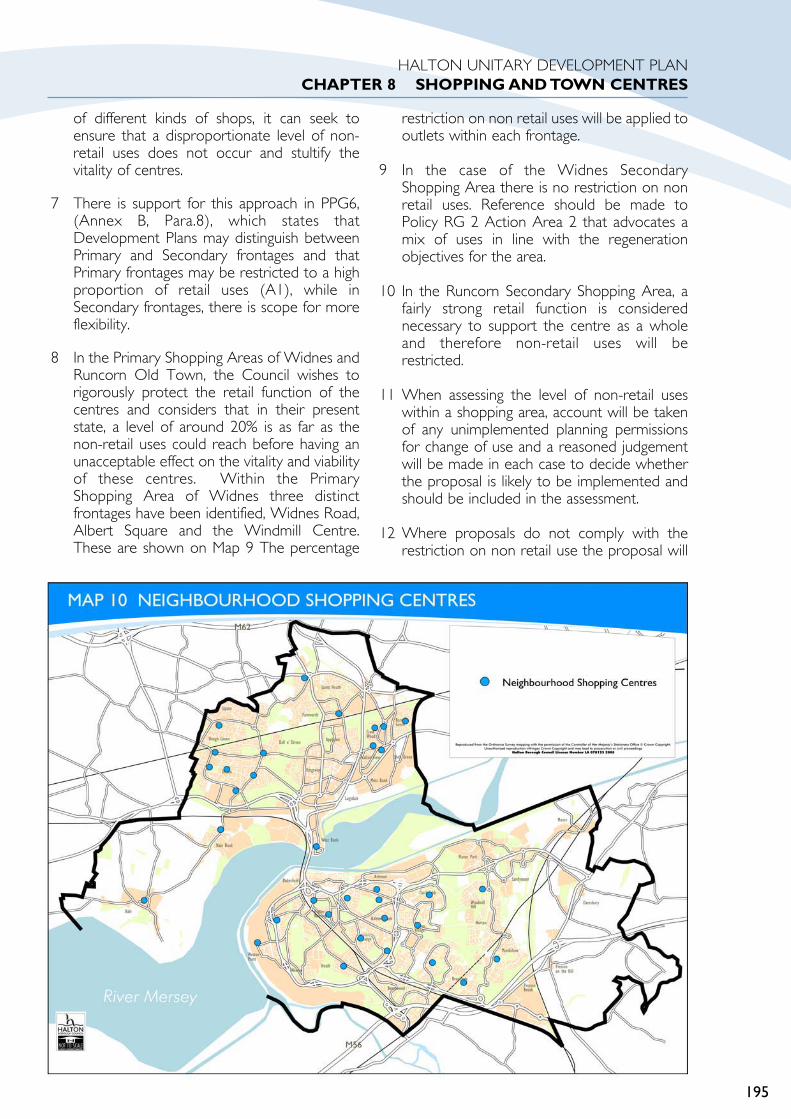
of different kinds of shops, it can seek toensure that a disproportionate level of non-retail uses does not occur and stultify thevitality of centres.
7 There is support for this approach in PPG6,(Annex B, Para.8), which states thatDevelopment Plans may distinguish betweenPrimary and Secondary frontages and thatPrimary frontages may be restricted to a highproportion of retail uses (A1), while inSecondary frontages, there is scope for moreflexibility.
8 In the Primary Shopping Areas of Widnes andRuncorn Old Town, the Council wishes torigorously protect the retail function of thecentres and considers that in their presentstate, a level of around 20% is as far as thenon-retail uses could reach before having anunacceptable effect on the vitality and viabilityof these centres. Within the PrimaryShopping Area of Widnes three distinctfrontages have been identified, Widnes Road,Albert Square and the Windmill Centre.These are shown on Map 9 The percentage
restriction on non retail uses will be applied tooutlets within each frontage.
9 In the case of the Widnes SecondaryShopping Area there is no restriction on nonretail uses. Reference should be made toPolicy RG 2 Action Area 2 that advocates amix of uses in line with the regenerationobjectives for the area.
10 In the Runcorn Secondary Shopping Area, afairly strong retail function is considerednecessary to support the centre as a wholeand therefore non-retail uses will berestricted.
11 When assessing the level of non-retail useswithin a shopping area, account will be takenof any unimplemented planning permissionsfor change of use and a reasoned judgementwill be made in each case to decide whetherthe proposal is likely to be implemented andshould be included in the assessment.
12 Where proposals do not comply with therestriction on non retail use the proposal will
195
HALTON UNITARY DEVELOPMENT PLANCHAPTER 8 SHOPPING AND TOWN CENTRES

be considered in light of the potential damageit would have on the viability and vitality ofthe centre .
TC 9 NON-RETAIL USES WITHINNEIGHBOURHOOD CENTRES
1 In the following neighbourhoodcentres Class A2 (financial andprofessional services) and Class A3(sale of food and drink) uses will bepermitted at ground floor levelprovided that the number of A2 or A3uses does not exceed approximately50% of the total outlets within thecentre.
Ascot Avenue, RuncornBechers,WidnesBrook Vale, RuncornCastlefieldsCronton Lane,WidnesDitchfield Road,WidnesFarnworth,WidnesHale Bank,WidnesHale Road,WidnesHalton Brook, RuncornHalton Road, RuncornLiverpool Road,WidnesMoorfield Road,WidnesMurdishaw Centre, RuncornPalacefieldsPicton Avenue, RuncornQueens Avenue,WidnesThe Grange, RuncornWindmill Hill, RuncornWeston Point
2 Proposals that would take the numberand concentration of non retail usesmarginally above the limits listedabove will be considered against thefollowing criteria whichever isappropriate:
a That the unit is no longer viable forretail purposes and that it hasremained vacant for a substantialperiod of time, despite evidence ofattempts to sell it or let it onreasonable terms.
b That it will not result in the loss ofa convenience goods store, postoffice or other retail outlet which isbeneficial to the vitality andviability of the centre.
c That the use of an existing buildingis supported on overridingenvironmental, urban renewal orhistoric/ architectural grounds.
d That the frontage of the propertyin question is narrow and as suchrepresents a poor retail premise.
e That the proposed development,because of its particular nature andqualities, will make an exceptionallyvaluable contribution to the vitalityand viability of the centre.
3 In the following neighbourhoodcentres Class A2 (financial andprofessional services) and Class A3(sale of food and drink) uses will bepermitted at ground floor level exceptwhere:
a The existing unit is a viableconvenience goods store or postoffice.
Alexander Drive,WidnesGreenway RoadHalton Lodge, RuncornHalton View Road,WidnesHalton Village, RuncornHough Green,WidnesLangdale RoadRussell Road, RuncornWarrington Road,WidnesWest Bank,
4 In the following neighbourhoodcentres conversion to residential usewill be permitted.
Bancroft Road
Castle Rise
5 In the following neighbourhoodcentres proposals for residentialdevelopment will be permittedprovided that:
196
HALTON UNITARY DEVELOPMENT PLANCHAPTER 8 SHOPPING AND TOWN CENTRES
TC9

a an appropriately sized shop orshops is provided in a prominentposition on the site or elsewherewithin the neighbourhood,accessible by a choice of means oftransport, with adequate short stayparking in front of the shops.
Barrows Green,Widnes
Hale Parade, Hale
JUSTIFICATION
6 The growing trend of less reliance on localshopping facilities in favour of doing both themain and top-up shopping in majorsupermarkets has ensured that nationally,retail representation within neighbourhoodcentres has declined rapidly.
7 The levels of patronage at neighbourhoodcentres within the Borough depend on boththe local community’s access to majorsupermarkets and on the range of goods onoffer at neighbourhood centres. The spatialconcentration of supermarkets in theBorough is such that some neighbourhoodsare some distance from a major supermarket.When this factor is combined with the lowlevel of car ownership in the Borough certainneighbourhood centres are in fact tradingstrongly and provide a diverse range of goodswhich meet the local needs of thosecommunities. In some centres retailers havebeen able to establish a niche market whichenables them to compete effectively for ashare of local expenditure.
8 The Neighbourhood Centre Audit (RetailIssues Study, Jan 1999) and NeighbourhoodCentres Study (Nov 1999) shows that thereare distinct contrasts in neighbourhood centreprovision within the Borough and as such thispolicy reflects this position.
9 In the more successful centres it is proposedthat restrictions on non-retail uses of 50%would be achievable without resulting inincreased vacancies. It is hoped that the retailmix in these centres can be maintained orimproved. The centres that are performingreasonably well which have limited vacantunits but are in need of environmentalimprovement have no restriction on A2 & A3uses to stimulate future demand.
10 By contrast however some centres areperforming badly, where the vacancy rates arevery high, appearance, retail mix and facilitiesare poor. As a result the poor environmentalquality of the centres blights the surroundingresidential areas. These centres have beenhighlighted for alternative uses either forresidential conversion where appropriate orresidential development combined with asmaller neighbourhood shop or centre whereviable.
MIXED TOWN CENTRE USESAREA
TC 10 RUNCORN TOWNCENTRE MIXED USES AREA
1 Within the Mixed Town Centre UsesArea of Runcorn as defined on theProposals Map, the following uses willbe permitted:
Financial and Professional Services(A2);
Food and Drink (A3);
Business uses (B1);
Hotels (C1);
Residential Institutions (C2);
Dwelling Houses (C3). Housingdevelopment may be appropriateas part of a mixed development;
Non-residential institutions (D1);
Assembly and leisure (D2);
Retail A1, provided it would servelocal needs;
Other non-retail uses appropriateto a town centre will be permitted.
JUSTIFICATION
2 PPG 6 paragraph 2.13 guides local PlanningAuthorities to set out policies for mixed usedevelopment in town centres by identifyingsuitable areas and sites. This area policyrelates to Runcorn Old Town whilst policyRG 2 Action Area 2 refers to the Central
197
HALTON UNITARY DEVELOPMENT PLANCHAPTER 8 SHOPPING AND TOWN CENTRES
TC10

Widnes area and fosters mixed usedevelopment in a regeneration context.
3 The concentration of a mixture of business,housing and supporting uses such as;restaurants, local shops and services close tothe town centre, increases activity and addsvibrancy and vitality to the town centre. TheRuncorn Mixed Town Centre Uses Area isintended to complement the shopping areasof the centre. It is not intended to providecompetition with the shopping areas thatmight undermine their retail function as wellas result in a more dispersed shopping centre.Consequently retail development proposalswithin the Mixed Town Centre Uses Area,including new build and change of use ofexisting buildings, should meet a local needand be of small scale.
FOOD AND DRINK OUTLETS
TC11 FOOD AND DRINKOUTLETS
1 Proposals for new build, extensionsand change of use of existing buildingsfor food and drink outlets (takeaways,restaurants, cafes, snack bars, publichouses and wine bars and other similaruses) will be permitted provided thatthey comply with all of the followingcriteria:
a Adequate short term customerparking is provide off street or atthe kerb side as a minimum, and nohazard to highway and pedestriansafety is created;
b the hygienic emission of fumes andsmells can be achieved effectivelywith external flues or ventilationducting designed and sited so thatthey do not detract from theappearance of the locality;
c An enclosed refuse area should beprovided on site. It should be ofan appropriate design and suitablylocated to minimise nuisance toadjacent uses.
JUSTIFICATION
2 Some food and drink outlets will beconsidered appropriate in town and
neighbourhood shopping centres and in alimited number of other locations inaccordance with the requirements of otherpolicies of the Plan.
3 Particular close scrutiny will be made ofproposals where there are residentialproperties, including flats above shops, whichthrough their general proximity andorientation are likely to be affected. Suchproposals will necessitate a detailedevaluation of potential levels of nuisanceincluding whether the associated noise willrise significantly above prevailing ambientlevels. The imposition of conditions will beconsidered to alleviate potential problems ofnoise, general disturbance, smell and litter byrestricting uses, activities and hours of openingin order to protect amenities of nearbyresidents. Whilst the last two issues aresubject to other statutory controls thesignificance of their impact will be consideredalong with other material considerations.
4 Adequate provision must be made for thedisposal of refuse arising from the operationof the business, including customer food anddrink containers. It should be fully recognisedthat where a development is deemedacceptable in principle but on detailedconsideration is found likely to generateunacceptable levels of noise, disturbanceand/or traffic generation which cannot beovercome through the imposition ofappropriate conditions, then planningpermission will be refused.
5 Applications should include, whereverpossible, details of the location of kitchens,extractor ducts, flues and other plant includingstorage and refuse areas. In accordance withthe policy these details will need todemonstrate that there will be no detrimentaleffects on the external appearance of thebuilding or the amenities of adjacent propertyand occupiers.
198
HALTON UNITARY DEVELOPMENT PLANCHAPTER 8 SHOPPING AND TOWN CENTRES
TC11

199
HALTON UNITARYDEVELOPMENT PLAN
CHAPTER 9HOUSING

AIMS AND OBJECTIVES
1 The policies within this Chapter look toachieving the aims and objectives contained inPart 1 of the Unitary Development Plan(UDP). The aims and objectives of the Plan,and therefore these policies, are concernedwith achieving a better balance between thenumber of jobs and residents, by meetinghousing needs and creating employmentwhich is accessible to local residents. Inaddition, the policies in the Plan are concernedwith creating sustainable residentialneighbourhoods, which are safe, attractive,accessible and self-sufficient.
BACKGROUND
PROVISION FOR NEW HOUSING
1 The housing policies and proposals aim is toensure that there will be sufficient housing tomeet the varied requirements of thepopulation up to 2016, through there being anadequate supply of land for housing, with achoice of location and a range of dwellingtypes and sizes, without harm toenvironmental quality.
CONTEXT
2 In March 1997, the Council commissionedconsultants Pieda Plc to undertake a studyexamining the urban capacity of the Borough.The study focused on both the demand andsupply side, determining the future residentialand employment requirements and providingan assessment of the real availability anddeliverability of housing and employment landin the Borough (Halton Urban Capacity Study,1997).
3 Following on from this study, additional sites,including open spaces, open countryside andGreen Belt land were reviewed to assess theirpotential to accommodate future housing andemployment requirements, andrecommendations were made as to thepossible mix of greenfield and previously-used(brownfield) land that could be allocated forhousing and employment in the UDP (HaltonStrategic Options - Scenario Building Report,1998). Further urban capacity research wascarried out to provide evidence for the UDPPublic Inquiry 2003.
4 In March 1999, the Council commissioned theUniversity of Manchester Housing ResearchGroup to undertake a study of housingrequirements in the Borough. An importantelement of this Study was to establish arelationship between various socio-economicfactors influencing demand and supplydecisions and local residents’ current housingneeds and preferences which would help theCouncil in considering the types of dwellingsand sites that should be planned for in theUDP (Halton Housing Requirements Study,1999).
5 Further work on urban capacity for housingdevelopment was undertaken for the 2003public inquiry into objections to the UDP.These have been published as inquirydocuments. In 2004 this work was updated forHalton as part of the Merseyside UrbanCapacity Study 2004.
BUILDING A SUSTAINABLECOMMUNITY
6 A key aim of the UDP is to achieve areduction in the rate of population decline andan improved balance between the quality andlocation of jobs and the number of residents in
200
HALTON UNITARY DEVELOPMENT PLANCHAPTER 9 HOUSING
Upton Rocks, Widnes

the Borough. This will be achieved by makingadequate provision for housing requirementsand creating new employment opportunitiesthat are accessible to local residents, which willhelp to stem net out-migration from theBorough.
7 In order to contribute to the reduction ofpopulation decline the policies in the Plan willensure that adequate land will be madeavailable during the period 1996-2016 to beconsistent with the figures allocated to Haltonwithin Regional Planning Guidance, nowtermed Regional Spatial Strategy, of 4,620dwellings (330 dwellings per year between2002 and 2016). This is in addition to the2,477 dwellings completed between 1996 and2002 (total 7,097).
8 Available land for housing within the urbanareas of Runcorn and Widnes is severelylimited. In Runcorn, this is due to the fact thatit is a new town with very few opportunitiesfor infilling. In Widnes private housebuildershave been reluctant to invest in sites that areheavily contaminated, not only because muchof the land is considered unsuitable forhousing but also as the average price of homesin Widnes has not enabled housebuilders tocover the costs of decontamination. TheCouncil will continue its efforts to securefunding from all available sources in order toimprove the prospects for development ofsites that may in the past have been toocontaminated to allow their development forhousing.
9 All available and potentially developable siteswithin, and immediately adjacent to theexisting urban area have been identified andincluded as commitments where they haveplanning permission or shown as allocations inPolicy H1. In order to meet the residualrequirement of the UDP, former opencountryside in east Runcorn and north Widneshas been allocated for housing development.Developers will be expected to contribute tothe funding of the development of publictransport linkages between the newdevelopments and existing employment,shopping and leisure opportunities within theexisting built up area, and new local centresand community facilities to serve the newdevelopments.
LINKING WITH THE SPATIALSTRATEGY
10 The strategy in Part 1 of the UDP is to createtwo sustainable communities at North Widnesand East Runcorn on the edges of the existingbuilt up areas at the same time as steps arebeing taken to regenerate existing housing andindustrial areas which are designated in theUDP as Action Areas. This linked strategyconforms to the preferred Greenfield andBrownfield Development Scenario describedin the UDP Key Issues Report, which wassubject to broad public consultation.
SUMMARY OF HOUSING PROVISION2002-2016
11 The residual dwelling provision is anestimation of the number of dwellings that willbe built on committed and allocated sites andon windfall sites during the remaining period ofthe Plan (May 2002 to May 2016). Wheresites already have planning permission or NewTown permission for development, thenumber of dwellings have been taken from theplanning application. Where sites did not have
201
HALTON UNITARY DEVELOPMENT PLANCHAPTER 9 HOUSING
Festival Way, Runcorn

planning permission (at May 2003), a minimumdensity of 30 dwellings per hectare wasapplied. On appropriate sites, densities higherthan 30 dwellings per hectare will beencouraged.
PLAN, MONITOR & MANAGE
12 In accordance with the Government’s PlanningPolicy Guidance Note on housing (PPG3)2000 a phasing policy has been introduced toensure that new uncommitted greenfieldhousing sites (phases 2 & 3) are only releasedfor development after brownfield sites andcommitted greenfield sites are developed inpreceding phases. This is described in moredetail in the justification to Policy H1.
13 Regular monitoring of land take-up, includingland not specifically allocated in the Plan, andof clearances, will enable the Council toreview the adequacy of the overall dwellingprovision. Additional brownfield windfalls maycome forward during the Plan period ascurrent land-uses become vacant andopportunities for redevelopment arise thatcould not have been planned for. Thesuccessful implementation of the Action Area
policies may bring forward additionalbrownfield sites for housing development,which may mean that the allocated sites inPhase 2 & 3 will be released later thanexpected.
RESIDENTIAL AMENITY
14 The UDP housing policies are also concernedwith ensuring a high quality of environment inresidential areas and the protection ofresidential amenity. Any proposals forresidential development, such as new housing,extensions and conversions, or other useswithin residential areas, will therefore beconsidered with regard to standards of designand residential amenity.
15 General requirements, relating toenvironmental quality, accessibility,conservation of the natural and historicenvironment, infrastructure and resourcesmanagement, that apply to all newdevelopments are contained within Policy BE1in the Built Environment Chapter. In addition,the criteria in Policy BE2 have been adoptedto ensure high standards of design and theprotection of residential amenity.
16 Supplementing the policies relating to newresidential development in the Plan,Supplementary Planning Guidance relating tonew residential development contains moredetailed guidance in relation to density, design,layout, recreational greenspace provision,landscaping, boundary treatment, road layout,parking, crime prevention and security.
AFFORDABILITY
17 Affordable housing is needed where there isan ‘affordability gap’ between people’sincomes and the cost of buying or renting inthe open market. The Halton HousingRequirements Study (1999) stated thataffordability in Halton was not an issue forthose in employment, and that there wasalready an adequate supply of affordable‘market’ housing in the Borough.
18 The Housing Requirements Study (1999)states (at p71) that a policy for a quota of“affordable” homes on sites with 25 or moredwellings or on sites of more than 1 hectaremight prove problematic, even in areas withhigher than average house prices, for a
202
HALTON UNITARY DEVELOPMENT PLANCHAPTER 9 HOUSING
Castlefields

number of reasons. The study goes on toquote examples, these include a reduction inthe attraction of social housing unitselsewhere, which would accentuate theexisting difficult to let problems beingexperienced by some social landlords. Theprovision of new affordable housingopportunities in outer wards will notnecessarily increase the wider opportunitiesavailable to local households who may nothave the means to commute or the skills totake up jobs in nearby employment hotspots.
19 The Housing Requirements Study concludesthat it is impossible to recommend a fixedtarget given Halton’s current housing stockbalance and demand characteristics. TheCouncil will however, continue to monitor theneed for affordable housing within theBorough. This may indicate a need to developa policy for affordable housing at some pointin the future.
20 In Halton, however, a significant proportion ofthe population is unemployed. This meansthat there is still a major role to be played bythe Council and Registered Social Landlords(RSL’s) in providing homes for those who donot have the option of becominghomeowners.
21 The ability of people in Halton to accesshousing on the open market is more of anemployment issue than a housing issue.Increased employment opportunities are thekey to providing people with greater housingchoice. The UDP has an important role toplay in facilitating employment opportunitiesfor those without jobs.
22 The need to diversify the Borough’s traditionalindustrial base, provide sites for a wide rangeof employment opportunities, and attract hightechnology and business investment in theBorough, has been addressed in theEmployment Chapter. In particular, it will beimportant to ensure that jobs created on theedges of the urban area are accessible toHalton’s residents by means other than theprivate car.
MOBILITY HOUSING
23 Part M of the Building Regulations 1991requires that all new houses built after 25thOctober 1999 are accessible to disabled
people. The Council welcomes theintroduction of Part M, which will ensure thatall new houses offer greater flexibility topotential households by removing some of thebarriers to changing patterns of occupation.
NEW TOWN SITES
24 Those housing sites in the former RuncornNew Town, owned by English Partnershipsand with Section 7.1 approval under the NewTowns Acts are mostly under the planningcontrol of English Partnerships, which has itsown planning powers over such sites until aninitial land disposal takes place. The Council,as a main consultee of English Partnershipsover future developments, will use the policiesin this chapter as a basis for its response to anyconsultations over these sites. When the landhas been sold to a private developer, theCouncil becomes the Local Planning Authorityfor that land and the Council’s policies willapply.
VACANCY RATES
25 The number of vacant properties in Halton iswithin the threshold needed to facilitate the
203
HALTON UNITARY DEVELOPMENT PLANCHAPTER 9 HOUSING
Future Dwellings, Castlefields

movement of households within the borough.Research undertaken by the NorthernConsortium of Housing Authorities showsthat in May 2001 around 1,758 dwellings werevacant in Halton, just above 4% (1,640dwellings) of total housing stock within Halton,needed to allow the market to operateefficiently.
HOUSING RENEWAL
26 The bulk of the housing stock in the Boroughis in a decent or moderate condition, so ingeneral the housing stock condition is unlikelyto be a matter of concern during the Planperiod. However, the largest problems ofhousing stock condition are likely to take placewithin pockets of the Borough, which sufferfrom low housing demand, which is the resultof relatively unpopular system built or terracedhousing types. In order to boost demand forhousing within some of these areas it will benecessary to undertake a program of clearanceand replacement of unpopular housing stockwith traditional lower density dwellings. Theprovision of new housing to diversify the mixof dwellings will be critical in providing marketchoice.
204
HALTON UNITARY DEVELOPMENT PLANCHAPTER 9 HOUSING

PART 2
POLICIES ANDPROPOSALSPROVISION FOR NEWHOUSING
H1PROVISION FORNEW HOUSING
1 In compliance with Part 1 Policy S18,land will be provided for new dwellingsin line with the building rate set byRPG13 (2003), now termed RSS, of 330dwellings per annum (net ofclearance), as from April 2002 onwards.Future housing development will bephased. Two phases are defined tocover the residual period from 2002 to2007 (5 years) and 2007 to 2011 (4years). A further 3rd phase will coverthe period 2011-2016 (5 years)
205
HALTON UNITARY DEVELOPMENT PLANCHAPTER 9 HOUSING
UDP PHASE 1: HOUSING PROVISION AND PHASINGHousing Completions & Requirement Requirement Annual
RatesPhase 1 RPG Allowance (Net of Clearance) 1,650 330(2002-2007)5 Years Estimated Demolitions/Clearance 170 34
Allowance for loss of dwellings in Castlefields Action Area 6 500 100Allowance for clearance within the Widnes Road & Broseley Square SPG Area 230 46
Gross Phase Housing Requirement 2,550 510UDP PHASE 1: HOUSING PROVISION AND PHASINGHousing Completions & Requirement Requirement Annual
RatesWINDFALLS Estimated PDL Windfalls 272 + 73 345 69
Allowance of Windfalls within the Castlefields Action Area 6 159 + 126 285 57
COMMITMENTS Greenfield CommitmentsNot Started 942 + 299 1,241 248Under Construction 205 + 0 205 41
PDL CommitmentsNot Started 216 + 0 216 43Under Construction 73 + 91 164 33
ALLOCATIONS Greenfield Dwelling Allocation 0 + 0 0 0
PDL Dwelling Allocation 80 + 0 80 16Gross Phase 1 Provision 1,947 + 589 2,536 507
H1
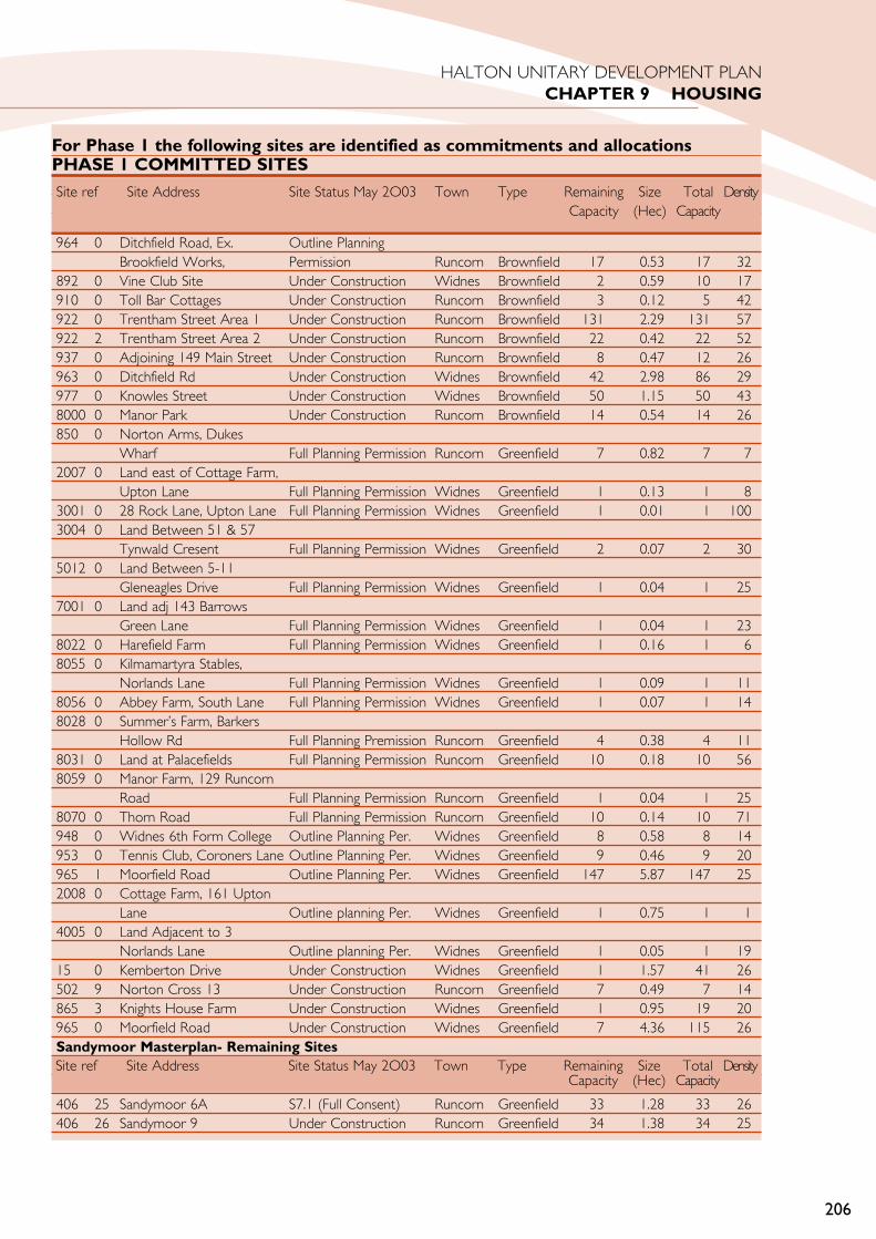
206
HALTON UNITARY DEVELOPMENT PLANCHAPTER 9 HOUSING
For Phase 1 the following sites are identified as commitments and allocationsPHASE 1 COMMITTED SITES
964 0 Ditchfield Road, Ex. Outline PlanningBrookfield Works, Permission Runcorn Brownfield 17 0.53 17 32
892 0 Vine Club Site Under Construction Widnes Brownfield 2 0.59 10 17910 0 Toll Bar Cottages Under Construction Runcorn Brownfield 3 0.12 5 42922 0 Trentham Street Area 1 Under Construction Runcorn Brownfield 131 2.29 131 57922 2 Trentham Street Area 2 Under Construction Runcorn Brownfield 22 0.42 22 52937 0 Adjoining 149 Main Street Under Construction Runcorn Brownfield 8 0.47 12 26963 0 Ditchfield Rd Under Construction Widnes Brownfield 42 2.98 86 29977 0 Knowles Street Under Construction Widnes Brownfield 50 1.15 50 438000 0 Manor Park Under Construction Runcorn Brownfield 14 0.54 14 26850 0 Norton Arms, Dukes
Wharf Full Planning Permission Runcorn Greenfield 7 0.82 7 72007 0 Land east of Cottage Farm,
Upton Lane Full Planning Permission Widnes Greenfield 1 0.13 1 83001 0 28 Rock Lane, Upton Lane Full Planning Permission Widnes Greenfield 1 0.01 1 1003004 0 Land Between 51 & 57
Tynwald Cresent Full Planning Permission Widnes Greenfield 2 0.07 2 305012 0 Land Between 5-11
Gleneagles Drive Full Planning Permission Widnes Greenfield 1 0.04 1 257001 0 Land adj 143 Barrows
Green Lane Full Planning Permission Widnes Greenfield 1 0.04 1 238022 0 Harefield Farm Full Planning Permission Widnes Greenfield 1 0.16 1 68055 0 Kilmamartyra Stables,
Norlands Lane Full Planning Permission Widnes Greenfield 1 0.09 1 118056 0 Abbey Farm, South Lane Full Planning Permission Widnes Greenfield 1 0.07 1 148028 0 Summer’s Farm, Barkers
Hollow Rd Full Planning Premission Runcorn Greenfield 4 0.38 4 118031 0 Land at Palacefields Full Planning Permission Runcorn Greenfield 10 0.18 10 568059 0 Manor Farm, 129 Runcorn
Road Full Planning Permission Runcorn Greenfield 1 0.04 1 258070 0 Thorn Road Full Planning Permission Runcorn Greenfield 10 0.14 10 71948 0 Widnes 6th Form College Outline Planning Per. Widnes Greenfield 8 0.58 8 14953 0 Tennis Club, Coroners Lane Outline Planning Per. Widnes Greenfield 9 0.46 9 20965 1 Moorfield Road Outline Planning Per. Widnes Greenfield 147 5.87 147 252008 0 Cottage Farm, 161 Upton
Lane Outline planning Per. Widnes Greenfield 1 0.75 1 14005 0 Land Adjacent to 3
Norlands Lane Outline planning Per. Widnes Greenfield 1 0.05 1 1915 0 Kemberton Drive Under Construction Widnes Greenfield 1 1.57 41 26502 9 Norton Cross 13 Under Construction Runcorn Greenfield 7 0.49 7 14865 3 Knights House Farm Under Construction Widnes Greenfield 1 0.95 19 20965 0 Moorfield Road Under Construction Widnes Greenfield 7 4.36 115 26Sandymoor Masterplan- Remaining Sites
406 25 Sandymoor 6A S7.1 (Full Consent) Runcorn Greenfield 33 1.28 33 26406 26 Sandymoor 9 Under Construction Runcorn Greenfield 34 1.38 34 25
Site ref Site Address Site Status May 2O03 Town Type Remaining Size Total DensityCapacity (Hec) Capacity
Site ref Site Address Site Status May 2O03 Town Type Remaining Size Total DensityCapacity (Hec) Capacity

207
HALTON UNITARY DEVELOPMENT PLANCHAPTER 9 HOUSING
UDP PHASE 2: HOUSING PROVISION AND PHASINGHOUSING COMPLETIONS & REQUIREMENT Requirement Annual RatesPhase 2 RPG Allowance (Net of Clearance) 1,320 330(2007-2011)4 Years Estimated Demolitions/Clearance 136 34
Allowance for loss of dwellings in Castlefields Action Area 6 400 100Gross Phase 2 Housing Requirement 1,856 464PHASE 2 PROVISION (MAY 2007 to APRIL 2011)Gross Provision Annual RatesWINDFALLS Estimated PDL Windfalls 276 276 69
Allowance for new build within Castlefields Action Area 6 228 228 57
ALLOCATIONS Greenfield Dwelling Allocation 1,410 1,410 353Gross Phase 2 Provision 1,914 1,914 479
Upton Rocks Masterplan-Remaining sites
933 2 Land North of Upton Lane Full Planning Permission Widnes Greenfield 87 2.01 87 4326 11 Upton Rocks Site D Outline Planning Permission Widnes Greenfield 74 4.96 74 1526 12 Upton Rocks Site H
(Central) Outline Planning Permission Widnes Greenfield 150 4.98 150 3026 15 Upton Rocks Site H (West) Outline Planning Permission Widnes Greenfield 69 2.30 69 3026 16 Upton Rocks Site (East) Outline Planning Permission Widnes Greenfield 153 5.09 153 3026 13 Upton Rocks Site L Under Construction Widnes Greenfield 58 4.36 119 2726 14 Upton Rocks Site P Under Construction Widnes Greenfield 110 4.99 144 29933 0 Land North of Upton Lane Under Construction Widnes Greenfield 103 6.48 192 30933 3 Land North of Upton Lane Under Construction Widnes Greenfield 53 3.81 59 15
Site ref Site Address Site Status May 2O03 Town Type Remaining Size Total DensityCapacity (Hec) Capacity
PHASE 1 ALLOCATED SITESInfill/Redevelopment Sites
921 0 Part Fairfield School Site UDP Allocation Widnes Brownfield 30 0.78 30 38934 0 Halebank Road UDP Allocation Widnes Brownfield 15 0.17 15 88938 0 Trinity Street UDP Allocation Runcorn Brownfield 9 0.06 9 150942 0 24-28 Widnes Road UDP Allocation Widnes Brownfield 5 0.03 5 1678001 0 Liverpool Road, Ditton UDP Allocation Widnes Brownfield 21 0.70 21 30
Site ref Site Address Site Status May 2O03 Town Type Remaining Size Total DensityCapacity (Hec) Capacity
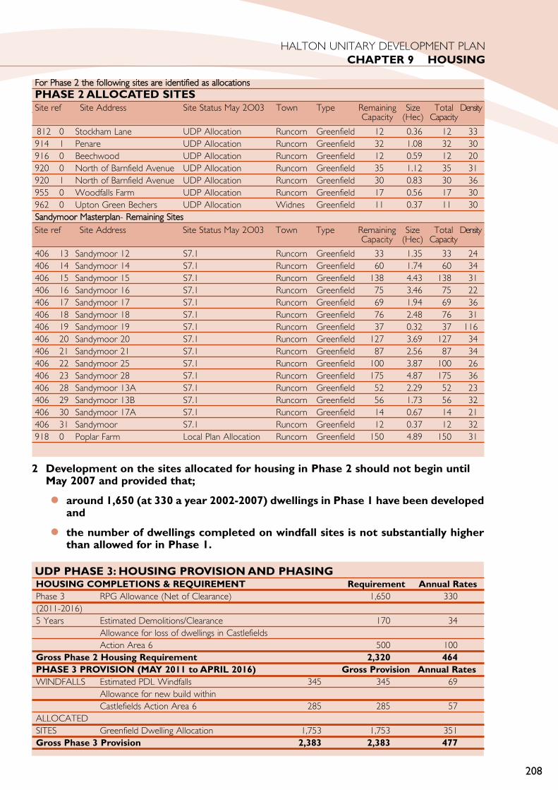
208
HALTON UNITARY DEVELOPMENT PLANCHAPTER 9 HOUSING
For PPhase 22 tthe ffollowing ssites aare iidentified aas aallocationsPHASE 2 ALLOCATED SITESInfill/Redevelopment SSites
812 0 Stockham Lane UDP Allocation Runcorn Greenfield 12 0.36 12 33914 1 Penare UDP Allocation Runcorn Greenfield 32 1.08 32 30916 0 Beechwood UDP Allocation Runcorn Greenfield 12 0.59 12 20920 0 North of Barnfield Avenue UDP Allocation Runcorn Greenfield 35 1.12 35 31920 1 North of Barnfield Avenue UDP Allocation Runcorn Greenfield 30 0.83 30 36955 0 Woodfalls Farm UDP Allocation Runcorn Greenfield 17 0.56 17 30962 0 Upton Green Bechers UDP Allocation Widnes Greenfield 11 0.37 11 30Sandymoor MMasterplan- RRemaining SSites
406 13 Sandymoor 12 S7.1 Runcorn Greenfield 33 1.35 33 24406 14 Sandymoor 14 S7.1 Runcorn Greenfield 60 1.74 60 34406 15 Sandymoor 15 S7.1 Runcorn Greenfield 138 4.43 138 31406 16 Sandymoor 16 S7.1 Runcorn Greenfield 75 3.46 75 22406 17 Sandymoor 17 S7.1 Runcorn Greenfield 69 1.94 69 36406 18 Sandymoor 18 S7.1 Runcorn Greenfield 76 2.48 76 31406 19 Sandymoor 19 S7.1 Runcorn Greenfield 37 0.32 37 116406 20 Sandymoor 20 S7.1 Runcorn Greenfield 127 3.69 127 34406 21 Sandymoor 21 S7.1 Runcorn Greenfield 87 2.56 87 34406 22 Sandymoor 25 S7.1 Runcorn Greenfield 100 3.87 100 26406 23 Sandymoor 28 S7.1 Runcorn Greenfield 175 4.87 175 36406 28 Sandymoor 13A S7.1 Runcorn Greenfield 52 2.29 52 23406 29 Sandymoor 13B S7.1 Runcorn Greenfield 56 1.73 56 32406 30 Sandymoor 17A S7.1 Runcorn Greenfield 14 0.67 14 21406 31 Sandymoor S7.1 Runcorn Greenfield 12 0.37 12 32918 0 Poplar Farm Local Plan Allocation Runcorn Greenfield 150 4.89 150 31
Site ref Site Address Site Status May 2O03 Town Type Remaining Size Total DensityCapacity (Hec) Capacity
Site ref Site Address Site Status May 2O03 Town Type Remaining Size Total DensityCapacity (Hec) Capacity
UDP PHASE 3: HOUSING PROVISION AND PHASINGHOUSING COMPLETIONS & REQUIREMENT Requirement Annual RatesPhase 3 RPG Allowance (Net of Clearance) 1,650 330(2011-2016)5 Years Estimated Demolitions/Clearance 170 34
Allowance for loss of dwellings in Castlefields Action Area 6 500 100
Gross Phase 2 Housing Requirement 2,320 464PHASE 3 PROVISION (MAY 2011 to APRIL 2016) Gross Provision Annual RatesWINDFALLS Estimated PDL Windfalls 345 345 69
Allowance for new build within Castlefields Action Area 6 285 285 57
ALLOCATEDSITES Greenfield Dwelling Allocation 1,753 1,753 351Gross Phase 3 Provision 2,383 2,383 477
2 Development on the sites allocated for housing in Phase 2 should not begin until May 2007 and provided that;
around 1,650 (at 330 a year 2002-2007) dwellings in Phase 1 have been developedand
the number of dwellings completed on windfall sites is not substantially higherthan allowed for in Phase 1.
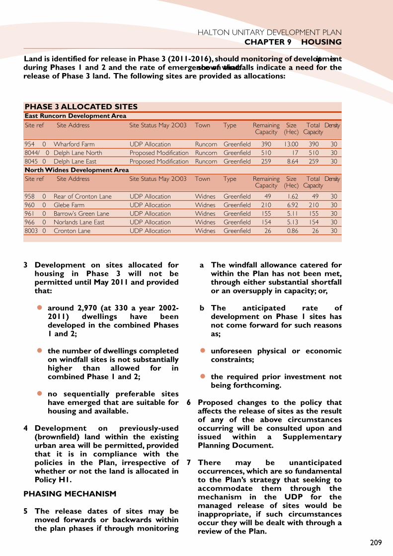
3 Development on sites allocated forhousing in Phase 3 will not bepermitted until May 2011 and providedthat:
around 2,970 (at 330 a year 2002-2011) dwellings have beendeveloped in the combined Phases1 and 2;
the number of dwellings completedon windfall sites is not substantiallyhigher than allowed for incombined Phase 1 and 2;
no sequentially preferable siteshave emerged that are suitable forhousing and available.
4 Development on previously-used(brownfield) land within the existingurban area will be permitted, providedthat it is in compliance with thepolicies in the Plan, irrespective ofwhether or not the land is allocated inPolicy H1.
PHASING MECHANISM
5 The release dates of sites may bemoved forwards or backwards withinthe plan phases if through monitoring
it isshown that:
a The windfall allowance catered forwithin the Plan has not been met,through either substantial shortfallor an oversupply in capacity; or,
b The anticipated rate ofdevelopment on Phase 1 sites hasnot come forward for such reasonsas;
unforeseen physical or economicconstraints;
the required prior investment notbeing forthcoming.
6 Proposed changes to the policy thataffects the release of sites as the resultof any of the above circumstancesoccurring will be consulted upon andissued within a SupplementaryPlanning Document.
7 There may be unanticipatedoccurrences, which are so fundamentalto the Plan’s strategy that seeking toaccommodate them through themechanism in the UDP for themanaged release of sites would beinappropriate, if such circumstancesoccur they will be dealt with through areview of the Plan.
209
HALTON UNITARY DEVELOPMENT PLANCHAPTER 9 HOUSING
PHASE 3 ALLOCATED SITESEast Runcorn Development Area
954 0 Wharford Farm UDP Allocation Runcorn Greenfield 390 13.00 390 308044/ 0 Delph Lane North Proposed Modification Runcorn Greenfield 510 17 510 308045 0 Delph Lane East Proposed Modification Runcorn Greenfield 259 8.64 259 30North Widnes Development Area
958 0 Rear of Cronton Lane UDP Allocation Widnes Greenfield 49 1.62 49 30960 0 Glebe Farm UDP Allocation Widnes Greenfield 210 6.92 210 30961 0 Barrow’s Green Lane UDP Allocation Widnes Greenfield 155 5.11 155 30966 0 Norlands Lane East UDP Allocation Widnes Greenfield 154 5.13 154 308003 0 Cronton Lane UDP Allocation Widnes Greenfield 26 0.86 26 30
Site ref Site Address Site Status May 2O03 Town Type Remaining Size Total DensityCapacity (Hec) Capacity
Site ref Site Address Site Status May 2O03 Town Type Remaining Size Total DensityCapacity (Hec) Capacity
Land is identified for release in Phase 3 (2011-2016), should monitoring of developmentduring Phases 1 and 2 and the rate of emergence of windfalls indicate a need for therelease of Phase 3 land. The following sites are provided as allocations:

JUSTIFICATION
IDENTIFYING AND ALLOCATINGSITES
8 In identifying sufficient land to meet the UDPhousing requirement, the Council has followedadvice contained in the Government’sPlanning Policy Guidance note “Housing” 2000(PPG3), and related best practice documents.
9 In accordance with para. 30 of PPG3, a searchsequence was followed:
starting with the identification of land andbuildings within the existing urban area,including that previously-used;
then identifying land and buildings locatedon the edge of the existing urban areawhich it was considered could form asustainable extension to it.
10 An initial scoping exercise of housing andemployment allocations, as identified in theHalton Local Plan, and potentialredevelopment sites known to the Council,was carried out by Pieda and is documented inthe Halton Urban Capacity Study (1997). Inparticular, the Study examined the potentialfor reallocating some of the Borough’semployment sites for housing. This wasfollowed by a wider study that examinedpotential development opportunities on openspaces, undesignated land and Green Belt land,as allocated in the Local Plan, and isdocumented in the Halton Strategic Options -Scenario Building Report (1998).
ALLOCATION CRITERIA
11 All land identified in the Plan has beenexamined against a series of marketability,developability and sustainability criteria, takinginto account the particular criteria identified inPPG3 (para. 31), to assess its potential andsuitability for development.
12 In relation to developability, sites wereassessed in terms of planning, access,infrastructure, contamination and ownershipconstraints. In relation to sustainability, siteswere assessed in terms of their location(within or outside the urban area), accessibility(whether accessible by public transport and/orwithin walking distance of local facilities),
physical characteristics (whether previously-developed) and environmental constraints(whether currently protected byenvironmental designations).
13 The last criterion in para. 31 of PPG3 isconcerned with the physical andenvironmental constraints on development ofland. In Halton the problem of contamination,in particular, presents a major and unusualrestriction on the availability of previously-usedsites suitable for housing. PPG3 alsoemphasises that ‘it is essential that theoperation of the development process is notprejudiced by unreal expectations of thedevelopability of particular sites’ (para. 34).Therefore it was considered important toexamine the marketability and developabilityof land for housing to ensure that sitesallocated in the Plan were capable of beingdeveloped. The potential supply of housingland was therefore also evaluated inaccordance with these requirements.
14 Large areas of land in the Borough are severelycontaminated as a result of past industrial andchemical processes and tipping. Whilesignificant areas have been successfullyreclaimed over the last few decades for openspace and, more recently, for employmentuses, redevelopment for housing raisessignificant environmental health, infrastructureand cost issues. A survey of vacant brownfieldland in the Borough, carried out in 2001, toidentify development potential, concluded thatthe vast majority of this land was not suitablefor housing.
15 In addition to examining the real availability ofland for housing, it was considered importantto take account of sustainability issues. Thishelped to identify priorities for developmentand potential problems that would need to beresolved through the planning process beforea site could be given planning permission fordevelopment. Sites were not necessarilyrejected on sustainability grounds if mitigatingmeasures could be required that would ensurethat a site could be developed in a sustainableway.
PLAN, MONITOR AND MANAGE
16 In the light of this research it has beennecessary to phase the release of housing inHalton to take account of local circumstances
210
HALTON UNITARY DEVELOPMENT PLANCHAPTER 9 HOUSING

211
HALTON UNITARY DEVELOPMENT PLANCHAPTER 9 HOUSING

which have resulted in a severe restriction onthe amount of previously used sites forhousing than would normally be expectedwithin an urban area.
17 PPG3 and its companion guidance ‘Planning toDeliver’ (2000) fully support phasing as asuitable mechanism for managing the releaseof housing sites over the Plan period. Phasingis a key device in the implementation of thePlan, Monitor and Manage approach. Para. 32of PPG3 states that the presumption will bethat previously-developed sites should bedeveloped before greenfield sites, and para. 31provides key criteria for assessing the potentialand suitability of sites. Proposals for therelease of Phase 2 and 3 greenfield allocationsahead of time would be refused planningpermission unless the criteria set out withinPolicy H1 are met.
18 The phasing policy allows for 3 phases. Eachsuccessive phase is designed to manage theincreasing level of uncertainty. This is in orderto achieve the aims of securing a greaterpercentage of development on previously-developed land and place greater emphasis onregeneration of the existing urban area, in thecontext of local factors.
19 The focus for Phase 1 and 2 is the existingurban area and land immediately adjacent to it.Development in Phase 1 and 2 will result inthe further intensification of the existing urbanarea, through development on infill sites andredevelopment of previously-used land, andplanned extensions to it, as part ofcomprehensive development proposals atSandymoor and Upton Rocks, previouslyidentified in the Halton Local Plan. Parts ofSandymoor and Upton Rocks have alreadybeen completed, parts are currently underconstruction, and parts are still undeveloped.The final stages of development at Sandymoorwill complete the master plan for Runcorn, asdrawn up by the New Town Corporation.
Phase 1:
20 Taking account of an allowance for ‘windfalls’,and ‘occupied clearances’, adequate provisionexists in Phase 1 to meet the Borough’shousing requirements to 2007 (at an averagerate of about 330 dwellings per year) withinthe existing urban area.
Housing provision in Phase 1 is made up of:
previously-used (brownfield) windfall sites;
allocated previously-used (brownfield)sites identified as having potential forhousing at May 2003;
committed sites that were underconstruction at May 2003;
committed sites with planning permission(outline or full) at May 2003.
Phase 2:
Taking account of an allowance for ‘windfalls’and ‘occupied clearances’, adequate provisionexists in Phase 2 to meet the Borough’shousing requirements from 2007 to 2011.
Housing provision in Phase 2 is made up of:
a previously-used (brownfield) windfall sites;
b Greenfield sites within the existing urbanarea and land immediately adjacent to it atUpton Rocks and Sandymoor.
Taking account of an allowance for ‘windfalls’and ‘occupied clearances’, adequate provisionexists in phase 3 to meet the Borough’shousing requirements from 2011 to 2016.
21 To meet housing requirements between 2011to 2016, and taking account of an allowancefor ‘windfalls’ and ‘occupied clearances’, it maystill be necessary to release more greenfieldsites for development in order toaccommodate additional households andensure a continued supply of housing land.
22 Housing provision in Phase 3 is made up of:
previously-used (brownfield) windfall sites;
allocated greenfield sites within the EastRuncorn and the North WidnesDevelopment Areas. These will beplanned as new sustainableneighbourhoods as extensions to theurban area as set out in S24.
23 A number of reasons why allocated siteswithin Phase 3 may not be required to meetRPG (RSS) requirements are envisaged,including:
212
HALTON UNITARY DEVELOPMENT PLANCHAPTER 9 HOUSING

Windfalls for the years up to 2011 couldexceed the figure set out within thispolicy;
Density assumptions currently built intoUDP housing calculations are increased;
Not all clearances/demolitions arereplaced within Phases 1 and 2 of the plan;
RPG (RSS) build rates change through thereview process, which is intended tohappen at least within 5 years and atsimilar intervals thereafter;
Sequentially preferable sites as defined inRSS policy DP1 ‘Economy in the Use ofLand and Buildings’ (in particular sites thatare in closer proximity in relation tohouses, jobs, other services andinfrastructure and are more accessible bypublic transport, walking or cycling) maycome forward or be identified through thePlan, Monitor and Manage process.
24 The phasing mechanism allows for the releasedates of sites in Phase 3 to be held back in theevent that any or a combination of thesecircumstances or unforeseen circumstancesoccur that would have the effect of meetingRPG (RSS) housing requirements without therelease of Phase 3 sites.
25 In accordance with Policy UR7 “RegionalHousing Provision” of Regional PlanningGuidance, now termed Regional SpatialStrategy, an allowance has been made in thePlan for:
Windfall Gains
69 dwellings per year on brownfieldwindfall sites.
57 dwellings per year on sites within theCastlefields Action Area 6
Demolitions and Clearance
34 demolitions per year;
Provision for a net loss of 231 demolitions(46 per year) that will take place withinthe Widnes Town Centre to allow for anew Superstore;
An allowance for a loss of 1,400 (57 peryear) dwellings within the Castlefields andNorton Priory Action Area.
The relatively low windfall figure reflects:
a The thoroughness of the initial surveywork carried out as a part of the NationalLand Use Database (NLUD) initiative thathas identified many sites that wouldpotentially have contributed towards theWindfall allowance;
b A relatively high allowance fordemolition/clearance rates to reflect localcircumstances relating to predictedsubstantial clearances within the ActionAreas.
26 It is expected that there will be a significantincrease in the demolition rate in theCastlefields & Norton Priory Action Areawithin the plan period. The full replacementof occupied dwellings is unlikely, because the1,400 properties to be demolished inCastlefields are made up of high rise / deckaccess flats. It is anticipated that only 60% ofthe demolished dwellings will be replaced inorder to improve the quality and diversity ofthe residential environment.
27 Windfall gains and clearance rates will beclosely monitored as part of the Plan Monitorand Manage approach. The monitoringprocess may identify unforeseen brownfieldwindfalls and clearances during the Plan periodin circumstances where current land-usesbecome vacant and opportunities forredevelopment arise that could not have beenplanned for. Additional opportunities forredeveloping larger areas of derelict andcontaminated land during the Plan period maycome forward through the Action Areapolicies in the Plan. The successfulimplementation of the Action Area policieswill help to regenerate the existing urban areasof Runcorn and Widnes. Any of theaforementioned circumstances may affect therelease of sites through phasing.
MANAGING THE RELEASE OF SITES
28 Regular monitoring of housing land take-upincluding land not specifically allocated in thePlan, will enable the Council to review theneed for further development in greenfield
213
HALTON UNITARY DEVELOPMENT PLANCHAPTER 9 HOUSING

sites in Phase 2 and 3. Where monitoringindicates that a persistent, and significant, gapexists between what has been planned for andwhat is occurring in reality, it will be importantto consider whether the plan’s approach tothe managed release of sites remains valid. Achange of approach may be required in theassignment of sites to phases. The monitoringprogramme may be used to re-assign sites todifferent phases without causing a formalrevision to the plan. Any proposedadjustments to the assignment of sites will bemade public through Supplementary PlanningDocuments (‘SPD’, which would ensure aneffective consultative route). This process willnot re-open the question of a site’s generalacceptability for development since that hasbeen tested through the plan process already.For more detailed information on the releaseof sites see the ODPM better practicedocument “Planning to Deliver” 2001.
PLAN ALTERATION ORREPLACEMENT
29 A number of situations can be envisagedwhich may lead to the policies in the planneeding to be altered or the plan replaced.These include:
a housing requirements changing in the lightof a strategic review of the annual rate ofprovision set out in RPG (RSS);
b insufficient windfalls arising, leading to a(consistent) shortfall in anticipated supply,raising the issue of whether greenfieldsites need to be allocated or plan policieschanged to facilitate a wider range ofwindfalls or to generate more windfallsfrom identified sources;
c significant additional windfalls comingforward consistently leading to excesssupply;
d anticipated planning applications not beingreceived for particular sites for reasonssuch as:
unforeseen physical or economicconstraints;
the required prior investment not beingforthcoming.
H2 DESIGN AND DENSITY OFNEW RESIDENTIALDEVELOPMENT
1 Densities of less than 30 dwellings perhectare net, should be avoided.Densities of 30-50 dwellings perhectare will be encouraged.
2 High density development of greaterthan 50 dwellings per hectare net willbe encouraged on sites in, or adjacentto, the existing built-up area, providedthat any of the following criteria canbe satisfied:
a The development contributes to amore sustainable pattern ofdevelopment by being withinreasonable walking distance of atown or local centre, or of anexisting or proposed railwaystation.
b The development provides housingfor special local needs such as smallunits for single persons or dwellingsfor the elderly or disabled people.
c Where feasible, the design ofdevelopment should incorporate amix of dwelling types and sizes, atvarying densities, to meet a widerange of housing needs.
JUSTIFICATION
3 This policy has been drafted in accordancewith Planning Policy Guidance note “Housing”2000 (PPG3), which states that local planningauthorities should encourage housingdevelopment that makes more efficient use ofland (between 30 and 50 dwellings perhectare net) and seek greater intensity ofdevelopment at places with good publictransport links, such as town orneighbourhood centres. For the purposes ofthe Plan, the definition of ‘net site density’contained in the ODPM publication ‘The Useof Density in Urban Planning’ and listed inPPG3 (Appendix D) has been adopted. Theterm “high density” refers to net site densitiesof over 50 dwellings per hectare.
4 Development with a net site density of over30 dwellings per hectare is better able to
214
HALTON UNITARY DEVELOPMENT PLANCHAPTER 9 HOUSING
H2

support local services, including shops, leisureand social facilities, as well as support andenhance the public transport network. Assuch, it can contribute to a more sustainablepattern of development. In addition, recentindependent research - The Halton HousingRequirements Study (1999) - found that therewas a large price gap between existing housingwithin the central areas of Widnes andRuncorn and the newly built propertiesaround the north and west fringes of Widnesand east fringes of Runcorn. Higher densitydevelopment consisting of a wider range oftype and size of dwelling may help to achievemixed sustainable communities and meethousing needs better.
5 The North Widnes and East RuncornDevelopment Areas will be expected toachieve a minimum density of 30 dwellings perhectare net overall. However, within theoverall development area, the design of thedevelopment should provide for a range ofdwelling types and sizes, at varying densities, tomeet a wide range of housing needs. As such,sub-sites within the development area mayhave densities of lower or higher than theminimum, provided that the target can beachieved as a minimum overall. A mixture ofsmaller houses suitable for first time buyersand larger houses suitable for families will beencouraged.
6 High density development (net site density of50 dwellings per hectare or more) can meet arange of different needs, both of a general andspecial nature. Reasonable walking distancewould be interpreted as approximately 400metres (depending on the topography).Specific guidance on the provision of specialneeds housing for the elderly is provided inPolicy H4.
7 Standards for car parking are stated asmaximum standards in Policy TP12, andprovision considerably lower than thesemaximums will be encouraged toaccommodate higher density development incompliance with this policy. In addition, PolicyH3 provides sufficient flexibility to allowdevelopers to meet the requirements forrecreational greenspace off-site or throughcontributions to improve and/or expand anexisting facility or create a new one. In the caseof sheltered housing and special needs housingfor elderly people, Policy H4 contains an
exception to the provision of recreationalgreenspace.
8 In the past, higher density development in theBorough has resulted in poor residentialamenity, which in turn has given rise tosignificant social and management issues,including difficult to let properties. If higherdensity is to work this time the quality of thedesign and layout of development will beparticularly important. High density does notnecessarily require high rise. The Halton UrbanCapacity Study (1997) demonstrated that withgood design higher densities could beachieved in all areas of the Borough, from theinner urban areas to the urban edge, withoutcompromising residential amenity. The designand layout of development should respect thecharacter and local distinctiveness of the area,and be of the highest quality.
REQUIREMENTS FOR NEWDEVELOPMENT
H3 PROVISION OFRECREATIONAL GREENSPACE
1 For new residential development,developers will be required to ensurethat there would be sufficientrecreational greenspace to meet thelocal needs of the people living there.
2 Proposals should include provisionwithin an agreed timescale inaccordance with the followingguidelines:
a In residential developments welllocated local open space should beprovided at a standard equivalentto 0.8 hectares per thousandpopulation for children’s play andcasual recreation and 1.6 hectaresper thousand population for formalsport and recreation.
b Where the proposed developmentis of sufficient size it will normallybe required to incorporatechildren’s playing space inaccordance with the structureoutlined in Table 1. The threecategories of play provision willsatisfy the 0.8 hectares perthousand population for children’splay/casual recreation.
215
HALTON UNITARY DEVELOPMENT PLANCHAPTER 9 HOUSING
H3

216
HALTON UNITARY DEVELOPMENT PLANCHAPTER 9 HOUSING
EXCEPTIONS TO ON-SITEREQUIREMENTS
3 It is required that as much as possibleof the 2.4 hectares per thousandpopulation should be provided on oradjacent to the proposed development.However, this requirement may bewaived where it can be demonstratedthat there is no practical alternative orthat it would be better to do so. Insuch circumstances, provision of therecreational greenspace off-site orthrough contributions to improveand/or expand an existing facility orcreate a new one will be permitted.Any off-site provision should be fairlyand reasonably related in scale andkind to the development proposal andbe in a location where it would be ofdirect benefit to the occupiers of thenew development.
OTHER EXCEPTIONS
4 Exceptions will be made in the case ofsheltered housing and special needshousing for elderly people in theprovision of playing space.
5 Exceptions (or partial exceptions) tothe provisions of this Policy will bemade where it can be demonstratedthat existing provision in the vicinityexceeds the minimum requirements asset out in this policy and includesadequate playing space on the basis setout in Table 1 such that it can meet all(or part) of the demand likely to begenerated by the new development.
JUSTIFICATION
6 Developers of new housing, excluding theexceptions set out in this policy, will beexpected to make adequate provision forrecreational greenspace either within oradjacent to the new development or in theform of financial contributions through Section106 agreements. Recreational greenspaceincludes playing space for formal sport andrecreation (based on the National Playing FieldAssociation (NPFA) definition of formalyouth/adult playing space) and playing spacefor children (based on the NPFA threecategories of play provision, as set out in Table1 below).
7 Policy GE12 and Policy GE15 of the GreenEnvironment Chapter provide additionalguidance on the provision of playing space andreinforce the minimum standards set out inthis policy. A review of existing provision in theBorough against these standards was carriedout in 1999 and showed that there weresignificant deficiencies. New residentialdevelopment will further compounddeficiencies by creating additional demand,which puts increasing pressure on existingfacilities.
8 Recreation greenspace will be required for anynew residential development. This will meanthat recreation greenspace provision will becalculated for the development of a singledwelling unit or a scheme for a number ofdwelling units. The exception to this will be,for example, for sheltered or special needshousing. Increasing emphasis upon windfallhousing development and on brownfieldrather than extensive Greenfield sites will
Time Walking Straight Minimum SizeNearest Characteristics Pop.Distance Line House (Approx)
DistanceActivity Total Property
Zone (inc Buffer) Boundary
LAP (Local Area for Play)1 min 100 m 60 m 100m(sq) 400m(sq) 5m from Small, low-key games area (may 50
(0.04ha) activity zone include “demonstrative”play features)LEAP (Local Equipped Area for Play)5 min 400 m 240 m 400m(sq) 3,600m(sq) 20m from About 5 types of equipment. 510
(0.36ha) activity zone Small games areaNEAP (Neighbourhood Equipped Area for Play)15 min 1,000 m 600 m 1,000m(sq) 8,500m(sq) 30m from About 8 types of equipment. 1210
(0.85ha) activity zone Kickabout and cycle play opportunities
TABLE 1

make the commuted payment an increasinglyimportant and necessary source ofcontribution to recreation greenspaceprovision.
9 This policy requires that all proposedresidential developments be assessed toestablish their recreational greenspace needs.In order that the system is equitable andeffective in keeping pace with development, itwill be applied to small residentialdevelopments and to net increases inaccommodation, such as in the case ofconversions and redevelopment, and alsowhere applications are made to renew existingresidential planning permissions.
10 In some cases, provision of open space at theabove rates, particularly formal open space,may not be practical or reasonable. Forexample, in smaller residential developmentsor developments with particular physicalconstraints. In other cases, it may beconsidered better to provide off-site provisionin order to achieve higher densities on site.This particular example would only beconsidered appropriate in locations that werewithin reasonable walking distance of a townor local centre in compliance with Policy H2,relating to the design and density of newresidential development. In all such cases, theCouncil may permit provision of open spaceoff-site or contributions towards publicprovision of open space within the area.
11 In the case of sheltered housing and specialneeds housing, developers will be required toprovide reasonable private garden space foruse by the residents in compliance with PolicyH4. However, it would not be necessary fordevelopers to provide additional playing spacein compliance with the provisions of thispolicy. A proposed new development may fallwithin the effective catchment area of anexisting recreation greenspace facility, whichwould be adequate in terms of the policystandards to cope with the needs of the newdevelopment in addition to those of theexisting population within the catchment. Insuch a case, there is no reasonable basis forimposing a requirement upon the developer inquestion to pay for additional facilities withinthe catchment area.
12 In the majority of cases, existing provision fallswell short of the minimum requirements as set
out in this policy. A review of existingprovision of playing space for formal sport andrecreation in the Borough against the adoptedstandard (1.6 hectares per 1000 population)was carried out in 1999 and showed thatthere were significant areas of deficiency in theBorough. A review of existing provision ofplaying space for children in the Boroughagainst the NPFA three tier hierarchy of playprovision was carried out in 1999 and showedthat there were significant deficiencies. Notonly are there some areas of the Borough withno playing spaces, the majority of those whichdo exist fall short of the specific NPFAstandards in terms of their quality, safety andcontent as set out in the “Six Acre Standard”.
CALCULATING THE REQUIREMENT
13 The exact requirement for the provision ofrecreational greenspace will depend on theanticipated population of the proposeddevelopment, which in turn will be related tothe size of the development and the size ofthe dwellings proposed. The anticipatedpopulation of the proposed development willbe calculated on the basis of an assumedpotential capacity for a particular sizeddwelling. The table below assumes a potentialcapacity of two persons in the first bedroomand only one in each of any additionalbedrooms.
Table of Potential Capacity of Dwellingspersons
1 Bedroom dwelling 2 2 Bedroom dwelling 3 3 Bedroom dwelling 4 4+ Bedroom dwelling 5
APPROACH TO CONVERSIONS
14 Where a single dwelling house is to beconverted to two or more self containeddwellings or flats a calculation shall be made toassess the net increase in the population. Usingthe above table it will be necessary to assessthe occupancy of the existing dwellings andsubtract this from the population, which willbe generated by the proposal. A contributionwill be required for each additional person.This ‘trade off’ can only apply where thebuilding remains at the time the planningapplication is made and is either converted or
217
HALTON UNITARY DEVELOPMENT PLANCHAPTER 9 HOUSING

is to be demolished to make way for thedevelopment.
PLAYING SPACE HIERARCHY
15 In relation to playing space for children, Table1 sets out three categories of play provision,based on the recommendations of the NPFA:
Local Area of Play (LAP)
Local Equipped Area of Play (LEAP)
Neighbourhood Equipped Area for Play(NEAP)
16 Where a new development is not of a size torequire all three categories of play provision itwill be necessary to provide as much aspossible of the standard. A developmentaccommodating approximately 50 peoplewould be required to provide a LAP. Allhouses should be within the safe prescribedwalking time of each type of playground. Usersshould not have to cross busy main roads orother hazards.
17 Opportunities to combine a LEAP and aNEAP in the same locality can achieveconsiderable savings in the amount of landneeded for the buffer zone, and marginalsavings in activity zone land use. However, aLAP should not be combined with a LEAP orNEAP because combining the different agegroups and facilities is not appropriate.
18 The play areas need to be of suitable shapeand topography to permit the activitiesoutlined in Table 1. This may not bepracticable in all cases and the requirementwill be relaxed where adequate justificationcan be given.
DEVELOPER CONTRIBUTIONS
19 Funds raised in lieu of physical provision willonly be used in a way that they are directlyrelated to reducing deficiency of open space inthe vicinity of the proposed development. Inthe case of playing space for formal sport andrecreation, it is considered that people travelsome distance to use the facilities. Acceptingthat there are two separate housing markets inHalton, and taking account of the significantcongestion problems on the Runcorn-WidnesBridge, it is considered that to ensure a direct
relationship between the development andthe future investment contributions, fundsraised in lieu of physical provision of playingspace for formal sport and recreation can onlybe used within the town where thedevelopment is proposed. That is, if thedevelopment is located in the town ofRuncorn, the contribution must be used withinthe town of Runcorn, and if the developmentis located within the town of Widnes, thecontribution must be used within the town ofWidnes.
20 In the case of playing space for children, threecategories of provision are identified in Table1 to meet the needs of children of differentage groups. To ensure a direct relationshipbetween the development and the futureinvestment contributions, funds raised in lieuof physical provision for children’s playingspace can only be used within 100 metres (ona LAP), 400 metres (on a LEAP) or 1000metres (on a NEAP) of the fundingdevelopment. The Council has developed astrategy that will create a network of LAP’s,LEAP’s and NEAP’s at existing sites within theBorough. Existing playing spaces identified ashaving the potential to perform the function ofa LAP, LEAP or NEAP with someimprovement are set out in supplementaryplanning guidance and a map showing thelocation of these. The Council may invest thefunds on other facilities provided that it wouldbe within the guidelines of this policy.
21 It is clear that some financial contributions, inthemselves, are not adequate to bring aboutimprovements immediately. When funds areadded to by other contributions andthresholds are reached monies will beemployed as soon as possible to improvefacilities. It is necessary for the Council to holdthe funds for a reasonable period of time toallow this process to take place. Furtherinformation on the implementation of thisPolicy is to be provided in SupplementaryPlanning Documents, which will contain moredetailed information, such as the formulae forcalculating the financial contribution towardscapital costs and commuted sum paymenttowards maintenance costs.
AGREED TIMESCALE FOR PROVISION
22 In all cases, conditions will be attached to theplanning application to ensure that the
218
HALTON UNITARY DEVELOPMENT PLANCHAPTER 9 HOUSING

219
HALTON UNITARY DEVELOPMENT PLANCHAPTER 9 HOUSING
required playing space is completed beforethe first homes are occupied. In largedevelopments, where a number of playingspaces are being provided to serve differentparts of the development, it may be practicalto phase the completion of the playing spacesin line with the phasing of the housingdevelopment. Such details will be the subjectof planning conditions or Section 106agreements in relation to individualapplications.
LONGER-TERM MAINTENANCE
23 In terms of maintenance, the Council willrequire developers to maintain or paycommuted sums for the maintenance ofrecreational greenspace. In cases where it isagreed between the developer and theCouncil that the Council will carry out themaintenance of open space on the developer’sbehalf it will be necessary for the developer topay a sum covering the future maintenance ofthe finished area.
H4 SHELTERED HOUSING
1 Proposals for sheltered housingdevelopment will be permittedprovided that all of the followingcriteria can be satisfied:
a The site is relatively level.
b The site is located withinreasonable walking distance of localcommunity facilities and is locatedso as to enable access to localcommunity facilities withinreasonable walking distance overlevel ground.
c Reasonable private garden space isprovided for use by the residents ofthe sheltered housing.
JUSTIFICATION
2 Sheltered housing is purpose built orconverted self-contained accommodation,with the support of a warden and often withcommunal facilities, normally designed for theuse of elderly people or for institutional care.Units without a warden or shared facilities willbe treated on the same basis as ordinary flatsand houses.
3 Dwellings for elderly people must be carefullylocated to minimise any disadvantages toresidents. The policy is designed to ensure thatonly sites and locations suitable for shelteredaccommodation are granted permission.
4 Special attention should be paid to thegradient of the site and surrounding area, theaccessibility of the site to the public transportnetwork, and the proximity of the site to localcommunity facilities, such as shops, postoffices, health care, libraries, day centres andpublic open space. Steep gradients should beavoided. Reasonable walking distance to localcommunity facilities would be interpreted asapproximately 400 metres (depending on thetopography).
5 In addition, developers will be required toprovide reasonable private garden space foruse by the residents of the sheltered housing.However, it would not be necessary fordevelopers to provide additional playing spacein compliance with Policy H3.
6 High density development (50 dwellings perhectare or more) will generally be acceptablefor sheltered housing provided that all thecriteria in the policy are met. The quality anddesign of such development will be particularlyimportant.
7 Where the development involves anextension to an existing building, Policy H6relating to house extensions will also apply.
8 The provision of adequate access for disabledpersons will be a valid consideration whenassessing planning applications for shelteredhousing, although detailed standards will becontrolled under the Building Regulations.
H5 GYPSY SITES
1 Proposals for the development of sitesto accommodate gypsies residing in orresorting to Halton will be permittedprovided that all of the followingcriteria can be satisfied:
a The site would not be affected bypollution or other environmentalfactors that would result inunacceptable living conditions.
b The site is well designed and
H4
H5

landscaped to give privacy betweenpitches and, where appropriate,between the site and adjacentusers.
c The site has adequate vehicularaccess and provision for parkingand circulation.
d The site has appropriate workareas, where required, so long astheir use would not createunacceptable air or noise pollutionor other nuisance, or present a riskto the health and safety of thoseliving on or near the site.
e The site is capable of facilitatingadequate sanitation.
f The proposals would not bedetrimental to the amenity orcharacter of the surrounding areaor be visually intrusive.
JUSTIFICATION
2 The Borough Council has provided andmanages one official 23 pitch capacity site atWarrington Road in Widnes. There arecurrently no gypsy owned or managed caravansites in the Borough. Any proposals for suchprivate sites will be considered in compliancewith the criteria in this policy. Circular 1/94“Gypsies and Planning” (1994) also providesguidance, with particular reference tocharacteristics of sites for settled occupation,temporary stopping and transit purposes.
3 People living in mobile homes have as muchright to a satisfactory environment andacceptable living conditions as those living inpermanent homes. As such, proposals for thedevelopment of sites to accommodate gypsiesin heavy industrial areas, which would beconsidered unsuitable locations for housing,would not be permitted.
4 Special attention should be paid to theamenity and character of the surrounding areaand the potential of the site to accommodatethe necessary infrastructure and trafficassociated with the development. Wherework areas are needed on the site, peopleliving nearby need the same protection frompollution or disturbance as from any otherbusiness or commercial activity near people’shomes.
EXTENSIONS ANDCONVERSIONS
H6 HOUSE EXTENSIONS
1 Proposals for house extensions will bepermitted provided that all of thefollowing criteria can be satisfied:
a The proposal would notunacceptably alter the appearanceor character of the original dwellingbut relate closely to it andharmonise with it in terms of theirscale, proportions, materials andappearance.
b The proposal would not createdangerous highway conditions byobstructing visibility forpedestrians or drivers of motorvehicles.
c Reasonable private garden space isprovided for use by the residents ofthe extended property.
JUSTIFICATION
2 A large proportion of planning applicationsreceived by the Council relate to houseextensions. Although most proposals for suchextensions are small-scale developments, theirimpact on the street scene and on the privacyand amenities of neighbouring occupiers canbe considerable.
3 Specific design guidance and the relevantstandards for the various types of houseextensions, including detached garages, are setout in the Council’s Supplementary PlanningGuidance on “House Extensions” (1998).
H7 CONVERSIONS TO FLATS
1 Proposals for conversions fromdwelling houses to self-contained unitswill be permitted provided that all ofthe following criteria can be satisfied:
a The dwelling house to be convertedis large enough to providesatisfactory living accommodationfor future residents.
b The conversion is possible without
220
HALTON UNITARY DEVELOPMENT PLANCHAPTER 9 HOUSING
H6
H7

the need for major alterations andextensions, or additional newbuildings which would unacceptablyalter the appearance or characterof the original dwelling.
c The units would be self-contained.
d Access to units is via the front ofthe dwelling house.
e All units have access to a yard orgarden area.
f A covered bin store is provided forthe use of residents.
g Where parking is to be provided inany area fronting a highway, onethird of that area is provided withsoft landscaping and screening.
h The conversion would not result inan over-concentration of convertedproperty to the detriment of thecharacter of the area and theamenity of residents.
JUSTIFICATION
2 A self-contained unit is one with its ownbathroom, w.c. and kitchen facilities behind itsown front door. Minimum floorspace standardand general requirements may be obtainedfrom the Housing and Environmental Healthservices of the Council. Approval will also berequired under Building Regulations to ensurethat the conversion is of the required standardwith regard to structure, fire safety, soundinsulation, ventilation and waste disposal.
3 The Government’s Planning Policy Guidancenote on “Housing” 2000 (PPG3) states thatplanning authorities should provide a greaterchoice and better mix of housing, in terms ofsize, type and location. The sub-division ofexisting dwelling houses into smaller houses orflats can help to create a better mix of dwellingtypes and sizes in established residential areas.In particular, it can be a way of providinglower-cost residential units for low income,small (e.g. one-person) households.Furthermore, the sub-division of a largebuilding may be the only way to economicallymaintain it and preserve it.
4 However, the Council also recognises thatcontrols are necessary to protect theenvironment and ensure those more modest-sized houses, especially terraced houses, aregenerally retained for single family occupation.
5 The existence of converted properties in astreet or area does not guarantee thatplanning permission will be granted for furtherconversions. If it is found that an over-concentration of converted property hasoccurred, indicated by a deterioration in theenvironmental quality, unacceptable trafficcongestion or an unbalanced social mix, theCouncil may decide that no more conversionswill be permitted within that area.
6 Proposals for conversions to flats of unusedaccommodation above shops (‘over the shop’schemes) will be encouraged, whereappropriate. Proposals for such conversionswill be considered with reference toappropriate parts of this policy, in particularparts 3 to 5.
7 In terms of design and accessibility, the Councilwill encourage developers to plan for disabledaccess on the ground floor of the conversionin compliance with Part M of the BuildingRegulations.
NON DWELLING HOUSE USES
H8 NON DWELLING HOUSEUSES
1 Within Primarily Residential Areas, asdefined on the Proposals Map,proposals for development other thanClass C3 (dwelling houses) will beconsidered mainly with regard to theireffect on residential amenity. In suchcases, development will be permittedprovided that all of the followingcriteria can be satisfied:
a The development itself would notdetract from the character of thearea or the amenity of residents.
b The development would not resultin an over-concentration of non-dwelling house uses to thedetriment of the character of thearea or the amenity of residents.
221
HALTON UNITARY DEVELOPMENT PLANCHAPTER 9 HOUSING
H8

c Where parking is to be provided inany area fronting a highway, onethird of that area should beprovided with soft landscaping andscreening.
JUSTIFICATION
2 Primarily Residential Areas are those areas ofthe Borough where housing is, and willcontinue to be, the predominant land use inthe area. These areas are defined as such onthe Proposals Map.
3 The overriding concern of this policy is inprotecting the amenity and public safety ofexisting residents, and conserving thecharacter and environmental quality of thesePrimarily Residential Areas.
4 While housing will be the predominant landuse in Primarily Residential Areas, the peopleliving there need some local facilities to meettheir everyday needs. Schools, churches,corner shops, a small doctors’ or dentalsurgery, and public houses can be appropriatenon-dwelling house uses provided that theyare subservient to residential amenity.
5 The majority of local shopping, leisure andcommunity facilities should be located in townand neighbourhood centres in compliancewith Policy TC4, Policy LTC1 and Policy LTC4.Proposals for small scale retail development orlocal leisure and community facilities outsideexisting shopping centres will be assessedagainst the criteria in Policies TC2, TC6 andPolicy LTC4, respectively.
6 Other land uses, which do not directly meetlocal needs, may also be acceptable withinPrimarily Residential Areas. Residential usesthat are non-dwellings - i.e. Class C1 (Hotels)and Class C2 (Residential Institutions), whichincludes residential homes, of the Town andCountry Planning (Use Classes) Order 1987 -may be suitably located within PrimarilyResidential Areas, but will be subject tosafeguards to protect the character andamenity of the area.
7 Small hotels and guesthouses may fit in withthe residential surroundings of PrimarilyResidential Areas. Large developments arelikely to cause problems of noise, traffic andparking and are unlikely to be acceptable.
Policy LTC9 provides guidance on appropriatelocations for larger hotel, conference andexhibition facilities.
8 There are also certain business activities, whichby virtue of their nature and scale canreasonably be carried out within PrimarilyResidential Areas without detriment toresidential amenity. Such business activities willtend to fall within Class B1 of the Town andCountry Planning (Use Classes) Order 1987.Class B1 is defined as: Use for or any of the following purposes:
a as an office other than a use within ClassA2 (financial and professional services);
b for research and development of productsand processes;
c for any industrial process, being a usewhich can be carried out in any residentialarea without detriment to the amenity ofthat area by reason of noise, vibration,smell, fumes, smoke, soot, ash, dust or grit.
9 In practice, it may be difficult to determine if anapplication for an industrial process is one thatwould fall within Class B1(c) as the effect onresidential amenity as defined above may bedifficult to assess.
10 Where necessary, temporary consent will begranted to monitor the impact of thedevelopment over a period of time, andconditions are likely to be imposed to restrictthe scale of the development and the hours ofworking. Any permissions granted may berestricted to the use applied for, and willnormally be subject to conditions to ensurethat residential amenity is protected.
11 Commercial childcare provision can also beappropriate in a Primarily Residential Area aswell as in the workplace. Policy LTC6 providesadditional guidance in relation to day nurseriesand playgroups, and will also be taken intoaccount when considering planningapplications for child minding operations.
222
HALTON UNITARY DEVELOPMENT PLANCHAPTER 9 HOUSING

223
HALTON UNITARYDEVELOPMENT PLAN
CHAPTER 10EMPLOYMENT

224
HALTON UNITARY DEVELOPMENT PLANCHAPTER 10 EMPLOYMENT
AIM AND OBJECTIVES
1 The policies within this Chapter look toachieving the aims and objectives containedwithin Part 1 of this Unitary DevelopmentPlan (UDP). The employment aims, andtherefore the policies in this Chapter, arerelated to promoting sustainable economicprosperity and creating new employmentopportunities in order to broaden theeconomic base and reduce unemployment. Itis particularly important to provideemployment opportunities that are accessibleto local residents.
BACKGROUND
PROVISION FOR EMPLOYMENTDEVELOPMENT
1 The UDP employment policies and proposalsseek to support the main aims of the plan totransform the quality of Halton’s environmentand improve economic prosperity and socialprogress through sustainable development by:
The allocation of sufficient supply ofemployment land to meet the needs ofindustry and business with a choice oflocation, size, type and quality.
Providing clear direction as to the type ofdevelopment considered acceptable.
Promoting economic diversification.
Requiring high standards of design inbuildings, layout, materials and landscapeworks.
CONTEXT
2 In March 1997, the Council commissionedconsultants Pieda Plc to undertake a studyexamining the urban capacity of the Borough.The study focused on both the demand andsupply side, determining the future residentialand employment requirements and providingan assessment of the real availability anddeliverability of housing and employment landin the Borough (Urban Capacity Study 1997).
Daresbury Laboratory

3 Following on from this study, additional sites,including open spaces, open countryside andGreen Belt land were reviewed to assess theirpotential to accommodate future housingand employment requirements, andrecommendations were made as to thepossible mix of greenfield and brownfieldland that could be allocated for housing andemployment in the UDP (Strategic Options -Scenario Building Report, 1998).
4 The Urban Capacity Study concluded that :
‘in order to succeed in the market for newemployment development and the attractionand retention of scarce mobile investment theBorough must therefore aim to maximise itsabilities to satisfy the more qualitative needs ofnew firms and those looking to relocate’(paragraph 5 Executive Summary).
5 It also highlighted a number of key issues forthe development of planning policy from theanalysis of the local industrial and businessmarket:
Demand for industrial and business land isconcentrated amongst local companies.Land should be allocated to satisfy this.
The majority of demand is industrialrelated and is particularly concentratedwithin the manufacturing sector. Demandis less apparent in the service sector. Landallocations should therefore primarily seekto satisfy the locational requirements ofmanufacturers.
Demand is greatest for sites of up to 4hectares - land use allocations shouldreflect this.
Widnes is disadvantaged in comparison toRuncorn due to an absence of attractive,readily available development land.Particular consideration needs to be givento addressing land supply deficiencies inWidnes.
6 The supply of employment land identified bythe Urban Capacity Study was 360 hectares.The study considered, however, that thisfigure represents a considerable overestimation of the true availability ofemployment land, particularly when thelocation and characteristics of individual sites
are set against the location requirements ofmodern industry.
7 The study consciously weighted the review ofemployment sites towards marketabilityfactors, which reduced the realisticallyavailable supply to approximately 190hectares.
8 As a consequence of the inequitabledistribution of employment sites betweenRuncorn and Widnes it is necessary to ensurethat there is a balanced portfolio of sitesbetween the two towns that operate asseparate markets. It is also important to tacklethe qualitative differences in the Widnesemployment land supply by putting forward aprincipal employment site in Widnes, whichwould prove attractive to both indigenousbusiness, and small scale inward investorswhich the town currently lacks.
9 The Council commissioned consultants toundertake an assessment of employment landin Widnes that concluded that there were noexisting employment sites that could meet theneeds of modern industry in Widnes. Itrecommended that a quality employment
225
HALTON UNITARY DEVELOPMENT PLANCHAPTER 10 EMPLOYMENT
thermPhos, Widnes

226
HALTON UNITARY DEVELOPMENT PLANCHAPTER 10 EMPLOYMENT
sites targeting Widnes’ service sector, locatedclose to the motorway network, served bypublic transport, unconstrained and hencereadily developable, should be allocated in theUDP.
LINKING WITH THE SPATIALSTRATEGY
10 The plan will make provision forapproximately 208 hectares of localemployment land. Between May 1996 andMay 2003 120 hectares of employment landwas completed therefore the residual amountof land to allocated in the Plan foremployment uses is 88 hectares.
11 A linked spatial strategy is proposed toachieve the Council’s strategic aims ofincreasing economic prosperity, stemming netout migration of population from theBorough and regenerating existing urbanareas. This entails the creation of sustainablecommunities on the edges of Widnes and
Runcorn linked to the regeneration of ActionAreas for housing, employment andrecreational uses.
12 The linked spatial strategy conforms to thepreferred Greenfield and BrownfieldDevelopment Scenario described in theHalton UDP Key Issues Report, which wassubject to broad public consultation.
Daresbury Park

PART 2 POLICIES ANDPROPOSALSPROVISION FOR NEWEMPLOYMENT DEVELOPMENT
E1 LOCAL & REGIONALEMPLOYMENT LANDALLOCATIONS
1 In accordance with Part I Policy S19,land is allocated for around 88hectares on the following localemployment sites.
227
HALTON UNITARY DEVELOPMENT PLANCHAPTER 10 EMPLOYMENT
Widnes Local Employment Sites Site Ref Area Greenfield/Previously Allocated (Ha) Developed Land Status Use Class
Ditton Road / Speke Road 142 1.44 PDL B1, B2 & B8Ex. Sleeper Depot, Ditton Jt 242 17.24 PDL B1, B2 & B8Fieldgate 219 0.67 PDL B1, B2 & B8Foundary Lane 34/3 1.15 PDL B1, B2 & B8Johnson’s Lane 49 8.66 Greenfield B1, B2 & B8Kingsway / Moor Lane Phase II 209/1 0.49 Greenfield B1Shell Green 28/0 6.02 Greenfield B1, B2 & B8Shell Green 28/3 5.95 Greenfield B1, B2 & B8Tanhouse Lane, Moss Bank Road 196 0.96 PDL B1, B2 & B8Land at Mill Lane 294/0 1.51 PDL B1, B2 & B8Land at Mill Lane 294/1 0.92 PDL B1, B2 & B8Quantity of Employment Land at Widnes 45.01
Runcorn Local Employment Sites Site Ref Area Greenfield/Previously Allocated (Ha) Developed Land Status Use Class
Adjacent Tannery Farm 249 2.47 Greenfield B1Davey Road (Astmoor) 53/5 0.39 Greenfield B1, B2 & B8Fairoak Lane 8/2 0.96 Greenfield B1, B2 & B8Land at Chester Rd,Whitehouse Vale 251 2.3 Greenfield B1Land at Rock Savage, Clifton Leave 252 1.46 Greenfield Roadside
User(PetrolStation,RestaurantHotel)
Manor Park II 236/1 1.11 Greenfield B1, B2 & B8Manor Park II 236/1 3.27 Greenfield B1, B2 & B8Manor Park II 236/4 1.04 Greenfield B1Manor Park II 236/6 1.47 Greenfield B1, B2 & B8Manor Park II 236/8 1.09 Greenfield B1, B2 & B8Manor Park III 237/0 15.32 Greenfield B1, B2 & B8Manor Park III 237/2 0.41 Greenfield B1, B2 & B8Manor Park III 254 10.46 Greenfield B1, B2 & B8Rivington Road (Whitehouse Vale) 8/1 1.57 Greenfield B1, B2 & B8Quantity of Employment Land in Runcorn (Ha) 43.32Total Quantity of Local Employment Land (Ha) 88.33
Widnes Local Employment Sites Site Ref Area Greenfield/Previously Allocated (Ha) Developed Land Status Use Class
Runcorn Local Employment Sites Site Ref Area Greenfield/Previously Allocated (Ha) Developed Land Status Use Class
E1

228
HALTON UNITARY DEVELOPMENT PLANCHAPTER 10 EMPLOYMENT
2 In accordance with Part I Policy S20,land is allocated for around 126hectares on Regional Investment Sites.
JUSTIFICATION
3 The process of identifying employment landallocations in the UDP took the followingstages:
An assessment of the demand and realavailability of employment land in theBorough, documented in the UrbanCapacity Study (1997).
An additional assessment of thedevelopment opportunity on openspaces, undesignated land and land in the
Green Belt as part of the StrategicOptions - Scenario Building Report (1998)which assessed three developmentscenarios;
Greenfield, brownfield andgreenfield/brownfield in meeting thefuture employment and housingrequirements of the Borough.
An examination of sites against a series ofmarketability, developability andsustainability criteria to assess their
Regional Investment Sites Site Area Greenfield/Previously Allocated Use ClassRef (Ha) Developed Land Status
Daresbury Park 241 29.65 Greenfield Growth target sectors within Use Class B1(a) & (b)
Daresbury Park 240/0 4.52 Greenfield Growth target sectors within Use Class B1(a) & (b)
Daresbury Park 240/7 7.64 Greenfield Growth target sectors within Use Class B1(a) & (b)
Ditton Strategic Rail Freight 255 45.7 PDL Strategic Rail Park Site 1 Freight parkDitton Strategic Rail Freight 256 2.1 PDL Strategic Rail Park Site 2 Freight parkNorth of Hale Bank Road 253 22.8 Greenfield Strategic Rail
Freight parkNorth of Daresbury Laboratory 225 5.22 Greenfield Growth target
sectors within Use Class B1
West of Daresbury Laboratory 246 3.34 Greenfield Growth target sectors within Use Class B1
East of Daresbury Laboratory 247 2.7 Greenfield Growth target sectors within Use Class B1
South of Daresbury Laboratory 250 2.34 Greenfield Growth target sectors within Use Class B1
Total quantity of Regional Investment Sites (Ha) 126.01
Regional Investment Sites Site Area Greenfield/Previously Allocated Use ClassRef (Ha) Developed Land Status
potential and suitability for employmentdevelopment.
An assessment of both the quality ofemployment land and level of demand foremployment sites in Widnes.
ALLOCATION CRITERIA
4 The important scoping work undertaken inthe Urban Capacity Study and StrategicOptions - Scenario Building Report providesthe background to Part 1 Policy S19 of theplan. This strategic policy sets out theobjective to provide a range of employmentsites spread between Runcorn and Widnes tomeet the future needs of industry andbusiness.
5 All allocated employment sites in the planwere examined against a series ofmarketability, developability and sustainabilitycriteria to assess their potential and suitabilityfor development.
6 In light of the large areas of contaminationpresent in the Borough as a legacy of pastindustrial and chemical processes it wasconsidered important to ensure that allocatedsites were realistically available foremployment use through examination of themarketability and developability of sites.
7 To assess the marketability of sites thefollowing question was posed; Is the siteattractive to the market?
8 Sites that were located in close proximatelyto markets, suppliers and labour, and hadgood transport links and good links with otherbusinesses were given a higher score thansites that were not in close proximately tothese factors.
9 To assess sites developability, the knownplanning, access, infrastructure, contaminationand ownership constraints were examined.Sites that had no known constraints weregiven a higher score than sites with knownconstraints.
10 Each site was also assessed against a set ofsustainable development criteria. The criteriawere designed to reflect governmentguidance on sustainable development asexpressed in Planning Policy Guidance. Thefollowing criteria were used;
Development within the existing UrbanArea - sites within the existing urban areawere given a positive sustainability score.
Development on previously developedland - sites previously developed weregiven a positive sustainability score.
Reclamation of contaminated land - sitesthat are contaminated were given apositive sustainability score.
Protection of high grade agricultural land -sites that were not of high agricultural landwere given a positive sustainability score.
Accessibility by public transport - sitesaccessible by public transport were given apositive sustainability score.
Accessibility by rail/water (freight) - sitesaccessible by rail/water (freight) weregiven a positive sustainability score.
11 The sustainability audit highlighted those sites,which obtained an overall negativesustainability score. Such sites were notrejected if mitigating measures could berequired that would ensure that a site couldbe developed in sustainable way. For instancesupplementary planning documents will beproduced for the sites identified in the NorthWidnes and East Runcorn DevelopmentAreas to ensure the creation of newsustainable communities to include a mix ofuses, accessible local facilities and goodtransport links with the existing urban area.Refer to part 1 policy S24 for moreinformation. In respect of Daresbury Park theCouncil set out in its Planning Brief forDaresbury Park (Jan 1996) and subsequentlysecured through Section 106 Obligations aspart of the planning approval for thedevelopment, high quality landscapingdesigned to be prominent within the site andfrom views to it. This was seen as an essentialelement of the development for theenjoyment of park users and to make apositive contribution to the character of thedevelopment and its setting.
12 The total quantity of employment landallocated in the UDP is made of 34% (72hectares) of Previously Developed Land and66% (142 hectares) of Greenfield Land.
229
HALTON UNITARY DEVELOPMENT PLANCHAPTER 10 EMPLOYMENT

230
HALTON UNITARY DEVELOPMENT PLANCHAPTER 10 EMPLOYMENT

13 The Regional Economic Strategy SummaryAction Plan (2003-2006) includes an action toestablish a major science campus atDaresbury Laboratories as a focus for worldclass research and development andcommercial activities. The expansion sites, tothe edges of the established complex, arerecognised as important sites with thepotential to support clustering around theexisting research facility with the scope todevelop linkages and shared resources.
14 Section 106 Obligations will be sought toensure that employment uses on regionalinvestment sites are in the target growthsectors identified in the North WestDevelopment Agency’s Regional EconomicStrategy (2000) and part 1 policy S20. Thegrowth target sectors identified in theRegional Economic Strategy (2000) and inparagraph 4.7 of Regional Planning Guidancefor the North West (2003) now termedRegional Spatial Strategy are:
Environmental technologies
Life science industries (biotechnology andpharmaceuticals)
Medical equipment and technology
Financial and professional services
Tourism
Computer software services and internetbased services
Creative industries, media, advertising andpublic relations.
E2 PRIORITY EMPLOYMENTREDEVELOPMENT AREAS
1 The Priority EmploymentRedevelopment Areas identified onthe Proposals Map are consideredsuitable for employment re-development as and when theybecome vacant, are fully reclaimedand when land assembly takes place.
JUSTIFICATION
2 These sites are identified as potentialemployment sites that require
redevelopment. Realising the potential ofthese sites will depend on the provision ofsignificant levels of resources to assist withdecontamination, infrastructure andreclamation works and therefore the re-useof these sites is part of a longer-termdevelopment strategy. If sufficient resourcesare forthcoming these sites could make aneffective contribution to the Borough’semployment land bank and increase theamount of new employment development onpreviously used ‘brownfield sites’. The Councilwill use its compulsory purchase powers tofacilitate the regeneration of these sites.
PRIMARILY EMPLOYMENTAREAS
E3 PRIMARILY EMPLOYMENTAREA
1 Development falling within UsesClasses B1 (Business), B2 (GeneralIndustry), B8 (Storage andDistribution) and Sui Generisindustrial uses will be permitted in thePrimarily Employment Areasidentified on the Proposal Map.
JUSTIFICATION
2 Primarily Employment Areas are those areasof the Borough where employment is and willcontinue to be, the predominant land use inthe area. These areas are defined as such onthe Proposals Map. Primarily EmploymentAreas are different from Action Areasidentified in the Regeneration Chapter, whichpromotes a mix of uses in a regenerationcontext.
3 Industries that have the potential to causenoise, smell, dust, noxious omissions, nuisanceor unacceptable loss of amenity tosurrounding uses are unlikely to be acceptablewithin or adjacent residential areas or withinbusiness parks or near recreational areas.They are best located within general or heavyindustrial areas where they are more likely tobe compatible with surrounding uses.However even in general or heavy industrialareas they have the potential to have anunacceptable impact on the operation ofadjacent industrial and commercial users (i.e.food processing) and as such whendetermining the location of such industries
231
HALTON UNITARY DEVELOPMENT PLANCHAPTER 10 EMPLOYMENT
E2
E3

232
HALTON UNITARY DEVELOPMENT PLANCHAPTER 10 EMPLOYMENT
the compatibility with surrounding uses will bea primary consideration.
4 The Council wishes to diversify the localeconomy away from the over dependence onheavy chemical industry and improve theenvironmental quality of the PrimarilyEmployment Areas through restricting theseindustries to appropriate locations and wherethe use already exists on site.
5 Sui Generis Industrial Uses are those that falloutside the B2 Class, which is described in theUse Classes Order as ‘use for carrying on ofan industrial process other than one fallingwithin class B1.’ The use of the term ‘industrialprocess’ is specifically defined in article 2 ofthe Use Classes Order. This definition doesnot for example include industrial uses listedin article 3 of the Order. There are alsoindustrial processes which are classified as suigeneris by the courts, such as abattoirs andchemical waste transfer stations.
E4 COMPLEMENTARY SERVICESAND FACILITIES WITHINPRIMARILY EMPLOYMENTAREAS
1 Development that provides a serviceor facility, which is complementary toand compatible with the surroundingindustrial uses and for which there is ademonstrable need, will be permittedwithin a Primarily Employment Area.
2 Housing, that forms an integral part ofa mixed use development, will bepermitted within a PrimarilyEmployment Area if it is located in or,adjacent to, a town centre.
JUSTIFICATION
3 This policy is intended to apply to applicationsfor uses such as a children’s day nursery, aservice provision (e.g. a bank, shop, restaurant,sandwich bar) or a conference facility withinPrimarily Employment Areas. Suchcomplementary services and facilities may beacceptable within a Primarily EmploymentArea where they are needed to serve theworkforce or to help the employment areafunction well.
4 Mixed use schemes incorporating office, retail,
and flatted accommodation in higher densitydevelopments in or adjacent to town centrescan create attractive and vibrant places wellsuited to a town centre location.
SPECIAL REQUIREMENTS FORNEW DEVELOPMENT
E5 NEW INDUSTRIAL ANDCOMMERCIAL DEVELOPMENT
1 Proposals for new industrial andcommercial development, includingextensions to existing premises, will beexpected to comply with the followingrequirements where applicable:
a To ensure that the development iscompatible with existing andproposed surrounding uses, inparticular adjoining residentialareas, Landscape buffer zones mustbe provided to separate uses.Other measures such as soundinsulation, pollution control andrestricted hours of working tominimise potential amenityproblems will be required.
b Unsightly outside storage areasmust be screened from public view.
c Open storage of loose materialswill not be permitted.
d Refuse storage areas must beenclosed.
JUSTIFICATION
2 The requirements of this policy are intendedto complement Policy BE1 and Policy BE2 inensuring that new industrial and commercialdevelopment is compatible with neighbouringuses, particularly residential areas and also toensure that the external appearance of adevelopment would not have a detrimentaleffect on the character of the surroundingarea. Where necessary the use of planningconditions and legally binding agreements tosecure these requirements will be considered.
E6 DARESBURY LABORATORIES
1 Development will be permitted on thisPrimarily Employment Area identified
E6
E5
E4
on the Proposals Map if it falls withinUse Class B1(a) & (b) and there is aclear case for it being situated here.The design and height of new buildingsshould be in harmony with its sensitiverural location.
JUSTIFICATION
2 The national and international importance ofthe Daresbury Laboratories for scientificresearch is a valuable asset of the Borough.There are clear benefits in locating relatedactivities on the same site. RegionalInvestment Sites (listed in policy S20) 246,225, 247 & 250 have been allocated on thefringes of the laboratories site to cater for itsfuture expansion requirements and tofacilitate the development of a businesscluster.
E7 DITTON STRATEGIC RAILFREIGHT PARK
1 A phased strategic inter-modal railfreight park will be developed on landat Ditton, Widnes in accordance withan overall master plan to be approvedas a Supplementary PlanningDocument. Within the defined parkSites 253, 255 and 256 are allocated fordevelopment. Development will bepermitted provided that it complieswith all of the following (and in thecase of 253 subject also to compliancewith paragraph 2 below):-
a It is for use by businesses thatwould utilise the railway for thetransportation of freight, and usesoffering support services to them.
b It would be of a quality suitable foroccupation by companies ofregional or national distributionimportance, which would give riseto additional new employmentopportunities for residents ofHalton and surrounding localauthority areas.
c It would not have a significantlyadverse impact on the environmentand on the amenity of localresidents, particularly in theHalebank areas, and would
contribute to urban regeneration.
d It would not prejudice theimprovement of the passenger railnetwork or improvements to itidentified in the UDP.
e It is demonstrated through adetailed Transport Assessment andTravel Plan that it would not have asignificant adverse impact on thelocal transport networks and trunkroad network.
2 Development will not be permitted onsite referenced 253 on the proposalsmap and known as land north of HaleBank Road, unless all of the followingalso apply:-
a It is part of a comprehensiveproposal for a strategic rail freightpark at Ditton in accordance withan agreed phasing plan.
b Development of the strategic inter-modal rail freight park on thepreviously developed sites 255 and256 identified on the proposals mapand policy S20 has alreadycommenced in accordance with anagreed phasing plan set outin a Supplementary PlanningDocument.
c Unless already implemented asadvance structural landscaping,landscaped buffer zones areprovided on the land shown asProposed Greenspace on theProposals Map to the south, eastand west of site 253.
d A warehouse developmentproposal comes forward of largerthan 25,000 sq metres floorspaceand of a sufficient size or characterthat would be incapable of beingaccommodated within theremaining areas in the definedPark.
e It is designed to be rail-served,including the provision of dedicatedrail sidings adjacent to it.
233
HALTON UNITARY DEVELOPMENT PLANCHAPTER 10 EMPLOYMENT
E7

234
HALTON UNITARY DEVELOPMENT PLANCHAPTER 10 EMPLOYMENT
f The layout of developmentincorporates measures actively todiscourage the direct movement ofgoods vehicles from the site to thelocal road network in the Halebankarea. In order to achieve this aim aroad system shall be provided toconnect Sites 253, 255 and 256where they are divided by publichighways or railway lines.
JUSTIFICATION
3 Intermodal for the purpose of this policy isunderstood to be where an interchange takesplace in the moving of container freightbetween at least two different modes in atransport chain, where one is rail.
4 The potential of the Ditton location tosupport rail-based freight development hasbeen highlighted in two reports:
a the Merseyside Freight Study, preparedfor the joint Merseyside authorities andHalton Borough Council by MDSTransmodal and WS Atkins ConsultantsLtd, June 2000;
b the Report identifying the StrategicRegional Sites, published by the NWDA inDecember 2001.
5 The Merseyside Freight Study wascommissioned to provide the basis for astrategy and action plans for freightdistribution within, to and from Merseysidethat would:
Promote future economic growth;
Reduce accidents, health risks, disturbanceand environmental damage;
Be affordable, practical and capable ofimplementation.
6 The Study drew on relevant policy guidanceat EU, national and regional level. It pointed tothe common theme that non-road modes(rail and waterborne transport) should bepromoted through land use policies thatlocate industrial and distribution developmentat rail or water connected sites to supportsustainable transport objectives. Attentionwas drawn to the EU’s strategy for revitalising
railways, including advice on theencouragement of “freight villages” at whichheavy transport users and supporting activitieswould be clustered in order to make best useof extensive intermodal facilities.
7 The Study noted the potential for the“extension and restructuring of the Dittonarea, exploiting the two new intermodalterminals, bringing into play redundant landand creating a new road link to the A5300.”The new road link would connect with theexisting primary road network. It would alsoensure that freight traffic generated from thisproposal would not directly enter Halebank,reducing its local impact. Ideally, the areawould become a managed and secure estateallowing internal freight movements off thepublic highway. It will be vital to create asuitable local ambience to attract newoccupiers and so properly exploit Ditton’sgeographical advantage.
8 The NWDA published its Regional EconomicStrategy in March 2003 and in its SummaryAction Plan 2003-2006 it identifies this site inKey Activity 9.1.
9 In Regional Planning Guidance for the NorthWest (2003), now termed Regional SpatialStrategy, policy T7 states that local authoritiesin the North West should develop freightstrategies through the local transport planprocess and they should satisfy themselvesthat the prime purpose of any proposed siteis to facilitate rail freight when allocating landin development plans. The Ditton StrategicRail Freight Park proposal supports thisintention as it will assist the transfer andhandling of freight on a key rail corridor ofinternational standards, through the provisionof an inter-modal interchange in a regionallystrategic location.
10 This policy facilitates the kind of developmentenvisaged in Regional Planning Guidance forthe North West (2003), now termedRegional Spatial Strategy, the MerseysideFreight Study and in the Regional EconomicStrategy (2003). It goes on to take account ofthe technical, commercial and environmentalconsiderations raised in discussion withexisting and potential new inter-modaltransport developers and operators. Thesehave shown that a balance of greenfield andbrownfield development will providepotential for a phased development of200,000 sq m rising to 400,000 sq m that will

support both the new rail infrastructure:including 800m sidings, an expanded inter-modal terminal, and the reclamation/decontamination costs associated with someof the previously-used sites. The ProposalsMap shows all land considered to havepotential for development as part of thescheme within the UDP period, but sites 253,255 and 256 are allocated for development asthe Core Areas of the development.
11 The policy sets out the safeguards needed toensure that the development takes place in acomprehensive manner, including thedevelopment of the previously developedareas in advance of development on thegreenfield areas. The greenfield site 253should not be developed in isolation orbefore the other areas of the proposed RailFreight Park. It is considered to be the key tofacilitating the reuse and regeneration ofcurrently contaminated and unattractivepreviously used land in the immediate areathat would otherwise remain as such. Theprovision of railway sidings will be required aspart of any proposal for the development ofsite 253. This requirement will be the subjectof conditions of any planning permission forsite 253.
12 Development of this facility should create asignificant number of jobs for local people andbe a driving force in diversifying the localeconomy, and support regional and nationalpolicies. It should also provide a realopportunity to make lasting improvements inthe quality of the built environment: and theCouncil will require that the design of newbuildings and landscaped areas are of highquality.
13 In relation to site 253, in particular, thelandscape buffer zones are consideredessential, and will be affected by detailedtechnical considerations involved in any EIAand in creating a new road link to the A5300.In addition, the angling pond in the south-eastern corner of the Greenspace strip shouldbe retained. Planning conditions and S106Obligations will be used to ensure thatenvironmental and amenity standards areprotected.
235
HALTON UNITARY DEVELOPMENT PLANCHAPTER 10 EMPLOYMENT

236
HALTON UNITARY DEVELOPMENT PLANCHAPTER 10 EMPLOYMENT

237
HALTON UNITARYDEVELOPMENT PLAN
APPENDICES
APPENDIX 1
TRANSPORT PARKINGSTANDARDS
The standards for car parking contained within thisAppendix are the maximum to be providedwithin any development. Previous standards usedwithin Halton referred to minimum parking spacerequirements. If developers wanted to providemore than the minimum, there were no groundsfor objection unless other site specificconsiderations deemed them to be inappropriate.These ‘maximum standards’ provide a greaterdegree of control on parking allowing for betterdemand management to meet strategicobjectives. Where it is shown that linked trips willbe undertaken utilising the parking made availablefrom a development thereby increasing the usageof that parking, then an increase in parking abovethe maximum may be acceptable. This will beconsidered on a case by case basis.
The increased use of bicycles is recommended bythe Royal Commission on EnvironmentalPollution. Levels of parking for bicycles areincluded alongside those for car parking withinthese standards. Cycle parking levels areexpressed as a minimum standard.
Provision of motor cycle parking should be madewithin each large development site, defined as asite with a total of 25 or more car parking spaces.The standard for this is one motor cycle space forevery 25 car parking spaces.
In order to meet the needs of disabled people andthose with restricted mobility, 10% of all carparking spaces shall be provided to mobilitystandard (minimum width 3.6 metres). No lessthan half of these spaces shall be signed as beingfor the exclusive use of disabled people. Whereless than 10 car parking spaces are to be provided,at least one space shall be provided to ‘mobilitystandard’. These should be provided in a safe andconvenient location.
Notes: -
All figures in sqm relate to gross floor area unlessotherwise stated.
* Relates to predominantly drive through/takeaway establishments. Drive through featuring
significant seating should be considered as aconventional restaurant.
** Having regard to the advice in PPG13 and thatparking guidance is more likely to influence modalchoice rather than car ownership rates, it is notconsidered appropriate to set maximum orminimum levels of parking for housingdevelopment. A flexible approach to parking inassociation with dwellings is consideredappropriate. These figures offer broad guidance asto the levels of parking which may be appropriatefor various types of housing development.
TRANSPORT ASSESSMENTS (TA)
Guidelines recommend that a TA should normallybe produced where one or other of the followingthresholds are exceeded: -
traffic to and from the development exceeds10% of the two way traffic flows on theadjoining highway
traffic to and from the development exceeds5% of the two way traffic flows on theadjoining highway where traffic congestionexists or will exist with the assessment periodor in other sensitive locations.
Furthermore there will be some developmentsthat will be so significant in size that TA’s shouldbe undertaken as a matter of course.
Major development for the purposes of providinga transport assessment is where the developmentis equivalent or greater than the following: -
Retail - 1,000 sqm
Assembly and Leisure - 1,000 sqm
Business uses (B1 & B2) - 2,500 sqm
Warehousing (B8) - 10,000 sqm
Residential - 200 units
Higher and Further Education - 2,500 sqm
Stadia - 1,500 seats
100 trips in/out combined in the peak hours
100 on site parking spaces
238
HALTON UNITARY DEVELOPMENT PLANAPPENDICES
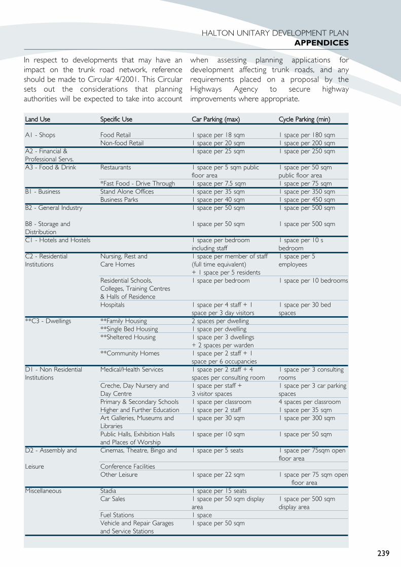
In respect to developments that may have animpact on the trunk road network, referenceshould be made to Circular 4/2001. This Circularsets out the considerations that planningauthorities will be expected to take into account
when assessing planning applications fordevelopment affecting trunk roads, and anyrequirements placed on a proposal by theHighways Agency to secure highwayimprovements where appropriate.
239
HALTON UNITARY DEVELOPMENT PLANAPPENDICES
Land UUse Specific UUse Car PParking ((max) Cycle PParking ((min)
A1 - Shops Food Retail 1 space per 18 sqm 1 space per 180 sqmNon-food Retail 1 space per 20 sqm 1 space per 200 sqm
A2 - Financial & 1 space per 25 sqm 1 space per 250 sqmProfessional Servs.A3 - Food & Drink Restaurants 1 space per 5 sqm public 1 space per 50 sqm
floor area public floor area*Fast Food - Drive Through 1 space per 7.5 sqm 1 space per 75 sqm
B1 - Business Stand Alone Offices 1 space per 35 sqm 1 space per 350 sqmBusiness Parks 1 space per 40 sqm 1 space per 450 sqm
B2 - General Industry 1 space per 50 sqm 1 space per 500 sqm
B8 - Storage and 1 space per 50 sqm 1 space per 500 sqmDistributionC1 - Hotels and Hostels 1 space per bedroom 1 space per 10 s
including staff bedroomC2 - Residential Nursing, Rest and 1 space per member of staff 1 space per 5 Institutions Care Homes (full time equivalent) employees
+ 1 space per 5 residentsResidential Schools, 1 space per bedroom 1 space per 10 bedroomsColleges, Training Centres& Halls of ResidenceHospitals 1 space per 4 staff + 1 1 space per 30 bed
space per 3 day visitors spaces**C3 - Dwellings **Family Housing 2 spaces per dwelling
**Single Bed Housing 1 space per dwelling**Sheltered Housing 1 space per 3 dwellings
+ 2 spaces per warden**Community Homes 1 space per 2 staff + 1
space per 6 occupanciesD1 - Non Residential Medical/Health Services 1 space per 2 staff + 4 1 space per 3 consulting Institutions spaces per consulting room rooms
Creche, Day Nursery and 1 space per staff + 1 space per 3 car parking Day Centre 3 visitor spaces spacesPrimary & Secondary Schools 1 space per classroom 4 spaces per classroomHigher and Further Education 1 space per 2 staff 1 space per 35 sqmArt Galleries, Museums and 1 space per 30 sqm 1 space per 300 sqmLibrariesPublic Halls, Exhibition Halls 1 space per 10 sqm 1 space per 50 sqmand Places of Worship
D2 - Assembly and Cinemas, Theatre, Bingo and 1 space per 5 seats 1 space per 75sqm open floor area
Leisure Conference FacilitiesOther Leisure 1 space per 22 sqm 1 space per 75 sqm open
floor areaMiscellaneous Stadia 1 space per 15 seats
Car Sales 1 space per 50 sqm display 1 space per 500 sqm area display area
Fuel Stations 1 spaceVehicle and Repair Garages 1 space per 50 sqmand Service Stations

240
HALTON UNITARY DEVELOPMENT PLANAPPENDICES
APPENDIX 2 : HOUSING ALLOCATIONS ( 2002 – 2016)
Brownfield Greenfield All SitesDwellings Gained Through New Build 283 290 573(April 2002-March 2003) 1 year 49% 51% 100%
Dwellings Gained Through Conversions 7 9 16(April 2002-March 2003) 1 year 44% 66% 100%
Dwellings Lost Through Conversions -1 0 -1(April 2002-March 2003) 1 year 100% 0% 100%
Dwellings Demolished -198 0 -198(April 2002-March 2003) 1 year 100% 0% 100%
Estimated Brownfield Windfalls 966 0 966(April 2002-March 2016) 14 years 100% 0% 100%
Estimated Demolitions/Clearance -2,106 0 -2,106(April 2002-March 2016) 14years 100% 0% 100%
Dwellings from Phase I Allocations 460 1,446 1,906Under Construction 164 205 369Plan allocations/ Lapsed Permissions 80 0 80Planning Permissions 216 1,241 1457(April 2002-March 2007) 5 years 24% 76% 100%
Dwellings from Phase II Allocations 0 1,638 1,638Plan allocations 0 1,638 1,638(April 2007-March 2011) 4 years 0% 100% 100%
Dwellings from Phase III Allocations 0 2,038 2,038Plan allocations 0 2,038 2,038(April 2011-March 2016) 5 years 0% 100% 100%
Total Dwelling Gain 1,716 5,421 7,137Total Dwelling Loss -2,305 0 -2,305Total (Net) -589 5,421 4,832

APPENDIX 3.
THE TOWN AND COUNTRYPLANNING (USE CLASSESORDER) 1987
A1 Shops
Shops, retail warehouses, hairdressers,undertakers, travel and ticket agencies, postoffices, pet shops, sandwich bars, showrooms,domestic hire shops, funeral directors.
A2 Financial and Professional Services
Banks, building societies, estate and employmentagencies, professional and financial services,betting offices. (These must serve the visitingpublic. Health and medical services are notincluded [in Class D1]).
A3 Food and Drink
Restaurants, public houses, snack bars, cafes, winebars, shops for sale of hot food.
B1 Business(a) Offices not within Class A2(b) Research and development, studios,
laboratories, ‘high tech’ uses.(c) Light industry
(These uses must be able to be carried out in aresidential area without detriment to the amenityof that area).
B2 General Industry
Any industrial use not falling within the BusinessClass.
B8 Storage or Distribution
Wholesale warehouses, repositories, wholesalecash ‘n’ carry, open storage.
C1 Hotels
Hotels, boarding and guest houses (where nosignificant element of care is provided).
C2 Residential Institutions
Residential homes for the care of people in need,hospitals, nursing homes and residential schools,colleges or training centres.
C3 Dwelling Houses
Dwellings, residences for up to six people living assingle households even where care is provided(includes flats).
D1 Non-residential Institutions
Community facilities such as: Places of worship,church halls, clinics, health centres, creches, daynurseries, consulting rooms. Museums, public halls,libraries, art galleries, exhibition halls.
Non residential schools, colleges and trainingcentres.
D2 Assembly and Leisure
Cinemas, concert halls, bingo halls, casinos, dancehalls. Swimming baths, skating rinks, gymnasia orareas for other indoor or outdoor sports orrecreation not involving motorised vehicles orfirearms.
Sui generis - unclassified i.e. any planning use notfalling within a specific Use Class above, and whichis therefore a use on its own.
Examples are:
Theatres
Amusement arcades or a funfair
Launderettes
Car Showrooms
Petrol filling stations
Taxi businesses and vehicle hire
Scrap yards
Car parks, lorry parks
Garage and transport depots
Open space
Hostels
Any work registrable under the Alkali etc. WorksRegulation Act 1906 (former Special IndustrialClass B3).
241
HALTON UNITARY DEVELOPMENT PLANAPPENDICES

APPENDIX 4
THE TOWN AND COUNTRYPLANNING (USE CLASSES)ORDER 2005The Use Classes Order 1987, outlined InAppendix 3, was in force at time that the UnitaryDevelopment Plan was drafted and adopted. Anew Use Classes Order came into effect on 21stApril 2005. Whilst the changes between the twoorders are quite minimal the Use Classes Order(2005) is summarised here for point of reference.
A1 Shops Shops, retail warehouses, hairdressers,undertakers, travel and ticket agencies, postoffices, dry cleaners, internet cafes, pet shops,sandwich bars, showrooms, domestic hire shops,funeral directors.
A2 Financial and Professional Services Banks, building societies, estate and employmentagencies, professional and financial services,betting offices. (These must serve the visitingpublic. Health and medical services are notincluded [in Class D1]).
A3 Restaurants and CafesRestaurants, snack bars, cafes
A4 Drinking EstablishmentsPubs and bars
A5 Hot Food Take-AwaysTake-Aways and fast food premises
Sui GenerisShops selling and/or displaying motor vehicles,retail warehouse clubs, launderettes, taxi orvehicle hire businesses, amusement centres, petrolfilling stations
B1 Business (a) Offices, not within A2
(b) Research and development, studios,laboratories, high tech
(c) Light industry
B2 General industry General Industry
B8 Storage or Distribution Wholesale warehouse, distribution centres,repositories
Sui GenerisAny work registrable under the Alkali, etc. WorksRegulation Act, 1906
C1 Hotels Hotels, boarding and guest houses (where nosignificant element of care is provided).
C2 Residential InstitutionsResidential homes for the care of people in need,hospitals and convalescent/nursing homes,residential schools and colleges.
C3 Dwelling housesDwellings, residences of up to six people living assingle households even where care is provided(includes flats), small businesses at home which donot change the character of the residential use.
Sui GenerisHostel, live/work units
D1 Non-residential InstitutionsPlaces of worship, church halls, clinics, healthcentres, creches, day nurseries, consulting rooms.Museums, public halls, libraries, art galleries,exhibition hallsNon - residential education and training centres
D2 Assembly and LeisureCinemas, music and concert halls, dance, sportshalls, swimming baths, skating rinks, gymnasiums.Other indoor and outdoor sports and leisure uses,bingo halls, casinos
Sui GenerisTheatres, nightclubs
242
HALTON UNITARY DEVELOPMENT PLANAPPENDICES

APPENDIX 5GLOSSARY
Action AAreaThese are areas within which wider Councilenabled regeneration efforts will be aided byflexible land use policies, allowing opportunitiesfor old redundant land uses to be replaced bynew uses such as open space, housing and newcommercial development.
AdvertisementsAs defined by the Town and Country PlanningAct 1990 “any word, letter, model, sign, placard,board, notice, device or representation, whetherilluminated or not in the nature of, and employedwholly or partly for the purposes ofadvertisement, announcement or direction, and(without prejudice to the previous provisions ofthis definition) includes any hoardings or similarstructure used, or adopted for use, for the displayof advertisements”.
Aerobic CCompostingBiological decomposition of organic wastes toform a fertile soil-like material, using aerobicmethods.
Affordable HHousingHousing accessible to people whose incomes areinsufficient to enable them to afford adequatehousing, locally, on the open market. Includesrented or shared ownership housing provided byhousing associations or Local Authorities and lowcost homes for sale at a discount.
AgricultureIncludes “horticulture, fruit growing, seed growing,dairy farming, the breeding and keeping oflivestock (including any creature kept for theproduction of food, wool, skins or fur or for thepurposes of its use in the farming of land), the useof land for woodlands where that use is ancillaryto the farming of land for other agriculturalpurposes”. Town and Country Planning Act 1990.Section 336.
Aggregates RRecycling FFacilityFacility for producing secondary aggregates fromconstruction and demolition wastes.
Agricultural LLand CClassificationAgricultural land classification maps are producedby the Department of Environment, Food andRural Affairs primarily for planning purposes. Land
is graded according to the degree to which itsphysical characteristics impose long-termlimitations on agricultural use.
Allocated LLandLand which is defined in the Local Plan as beingacceptable in principle for development for aparticular purpose and which is not already in usefor that purpose. The development of all suchsites will be dependent on planning permissionbeing obtained.
AllotmentsAn area of open land, usually in one ownershipbut divided up into separate plots, which are thenrented by individuals. These people usually growflowers, fruit and vegetables for their ownconsumption. Allotments are also sometimesreferred to as “leisure gardens”.
Anaerobic DDigestionBiological decomposition of organic wastes carriedout in sealed vessels to form compost materialsand produce gas.
Ancient WWoodlandsThose sites which have been continuouslywooded since at least the year 1600 and all suchsites within the Borough have been identified byEnglish Nature and Cheshire Wildlife Trust. Theyare of great historical, ecological and landscapeimportance and this is recognised by theGovernment in the England Forestry Strategy.
Archaeological EEvaluationResearch comprising a minimum of professionalarchaeological assessment and/or investigationneeded to determine the extent and importanceof archaeological remains whilst causing theminimum of damage to archaeological strata. Maybe limited to documentary research only.
Areas oof SSpecial LLandscape VValueThese areas may be made up of several distinctlandscape components (e.g. woodland, meadow,watercourses, hedgerows, topographical features,geological features, buildings, artefacts, etc.) whichcombine to create an important wider landscape.Alternatively, they may include one specific type oflandscape component on a large scale (e.g. a riverestuary or forest). Either way, they make animportant contribution to the local character ofthe Borough. In order to retain the character thatmakes these areas special, it is important that nodevelopment is allowed which fragments an area,or changes its character.
243
HALTON UNITARY DEVELOPMENT PLANAPPENDICES
Borrow PPitsTemporary quarries to provide fill materials,usually close to and connected with large-scaleconstruction projects.
Brownfield SSiteLand that has previously been developed.
Business PParkSite with a high standard of development andlandscaping accommodating a range of businessuses (light industry, offices, research anddevelopment) storage and distribution.
Business UUseThis is defined in Class B1 of the Town andCountry Planning (Use Classes) Order 1987 (S11987 No 764) and includes use as an office otherthan a use within Class A2 (financial andprofessional services), for research anddevelopment of products or processes or for anyindustrial process being a use which can be carriedout in any residential area without detriment tothe amenity of that area by reason of noise,vibration, smell, fumes, smoke, soot, ash, dust orgrit.
Caravan SSiteA static caravan site is a site that is occupied bycaravans positioned there for some specifiedperiod or for the whole year. These sites arenormally rented from a site owner.
A transit caravan site is a site that acts as astopping point on or near a through route wheremobile caravans can stay overnight. These sitesare normally for recreational purposes only.
COMAH SSiteDevelopment of sites designated under theControl Of Major Accident Hazards (Planning)Regulations 1999.
Committed SSiteLand which is already considered as beingacceptable for a particular purpose by virtue ofhaving an approved or past planning permission,an existing allocation, or which is presently underconstruction.
Community FForestA large area of wooded landscape in and aroundtowns containing a mixture of woodlands andother land uses including farmland, villages, leisureenterprises, nature areas and public open space.
Conservation AAreaAreas of special architectural or historic interest,the character or appearance of which it isdesirable to preserve or enhance. Such areas aredesignated by Local Planning Authorities underthe Town and Country Planning Acts.
Contaminated LLandLand which is polluted by noxious or toxicsubstances.
Construction aand DDemolition WWastesMasonry and rubble wastes arising fromdemolition, construction or other civil engineeringprojects.
CoastThe place where the sea meets land.
Coastal ZZone ddevelopedUsually urbanised but also containing other majordevelopments (e.g. ports, power stations, etc).
Coastal ZZone uundevelopedConserved both for its landscape value and for itsnature conservation interest.
Derelict LLandLand so damaged by industrial or otherdevelopment that it is incapable of beneficial usewithout treatment (Circular 68/65 MHLG).
This includes disused spoil heaps, worked-outmineral excavations, abandoned industrialinstallations and land damaged by miningsubsidence. It excludes land derelict from naturalcauses, land still in use and land with a planningpermission containing conditions requiring after-treatment.
Designated SShopping CCentresThese are the town centres (made up of primaryand/or secondary shopping areas) andneighbourhood centres listed in policy S16 andannotated on the proposals map.
DevelopmentDefined in Section 55 of the Town and CountryPlanning Act 1990 as:“The carrying out of building, engineering, miningor other operations in, or, over or under land, orthe making of any material change in the use ofany buildings or other land.
Economic DDevelopment ZZone ((EDZ)An Economic Development Zone is an
244
HALTON UNITARY DEVELOPMENT PLANAPPENDICES

opportunity driven regeneration initiative that is ofregional significance.
Energy-FFrom-WWaste ((EFW)The recovery of energy from waste materials,such as heat from incineration, or gas generation.
Environment AAgencyThe Government body with responsibility forprotecting and improving the environment inEngland and Wales. Their remit covers issuesrelating to the state of land, air and water.
Environmental IImprovementLandscaping and other measures taken toimprove the appearance and character of an area.
Environmental PPriority AAreaAreas designated by the Council that requiresignificant environmental improvement toenhance their character and appearance, due tocurrent environmental degradation.
FreightTransportation of goods in containers or by water,air or land.
General PPermitted DDevelopment OOrder ((GDPO)Sets out those categories of development thatmay be carried out without the need to apply forplanning permission i.e. “permitted development”.The Local Authority can seek to make a legaldirection requiring planning permission to beobtained for development that would normally bepermitted by the Order. Such a direction isknown as an Article Four direction.
Green BBeltArea of land, largely rural in character, which isadjacent to the main urban areas and which isprotected from development by permanent andsevere restrictions on building. The emphasis ison restricting the sprawl of urban centres,preventing the coalescence of neighbouring townsand preserving the individual character ofsettlements, although Green Belts may alsoprovide suitable locations for recreationaldevelopment and act as a buffer between themost rural countryside and the pressure ofgrowing towns.
Greenfield SSiteLand on which no development has previouslytaken place.
GreenspaceAll openspace of public value, including not justland, but also areas of water such as rivers, canals,lakes and reservoirs which offer importantopportunities for sport and recreation and can actas a visual amenity
Green WWasteGarden wastes from householders or landscapecontractors.
GypsyPerson of nomadic habit of life, whatever theirrace or origin. (This does not include members ofa group or organised travelling show people orcircus people).
Hazardous IIndustryAn industry or related installation which becauseof the nature of its process or the raw materialsused present a potential threat to the safety ofemployees or the general public. It will have beencertified a hazard by the Health and SafetyExecutive.
Health aand SSafety EExecutiveA body set up under the 1974 Health and Safetyat Work Act, responsible for safeguarding thehealth, safety and welfare of workers and thepublic, as well as providing an advisory service tolocal planning authorities on hazards and riskassessment.
Highways AAgencyAn executive agency of the Department forTransport responsible for the management andmaintenance of the motorway and trunk roadnetwork in England.
Household oor DDomestic WWasteWastes arising from private houses, caravans,residential homes etc.
Housing LLand SSupplyThe number of additional dwellings becomingavailable, either under construction or on landwith planning permissions, or allocated within aLocal Plan.
HydrocarbonsPrincipally oil, gas and coal bed methane.
IncineratorsWaste disposal facilities utilising high temperaturecombustion processes.
245
HALTON UNITARY DEVELOPMENT PLANAPPENDICES

Industrial WWasteWaste from factories and industrial andcommercial facilities.
Inert WWasteWastes that do not undergo any significantphysical, chemical or biological transformation.
InfillingThe filling of a small gap in an otherwise built-upfrontage. (A small gap is one that could be filledby one or two houses). Where a site couldaccommodate more than 2 dwellings it will betreated as being a small group.
InfrastructureWhen referring to a particular site it is the systemof communications and services, i.e. water supply,electricity, gas, drainage required before newdevelopment can begin. When referring to awider area the term includes the provision ofmore general services such as schools, shops andpublic transport.
In-mmigrationPeople moving into Halton to live from outsidethe Borough.
Inter-mmodalInter-modal is defined by the SRA as a loadcarrying ‘box’ designed to be conveyed by morethan one transport mode with transfer betweenmodes.
LagoonsSites where liquid wastes are deposited to allowthe suspended solids to separate out from theliquids.
Landfill GGasGas, principally methane and carbon dioxide,resulting from the biological decomposition ofwastes within a landfill site.
Landfill TTaxTax imposed by the government on wastesdisposed of in landfill/landraising sites.
LandfillingThe process of depositing waste into a void,hollow or cutting, to raise the level of the land tosurrounding ground levels.
LandraisingThe process of depositing waste into a void,hollow or cutting, to raise the level of the land tosurrounding ground levels.
LeachatePotentially polluting liquid resulting from thebiological decomposition of wastes within a landfillsite.
Listed BBuildingA building included in a list compiled by theDepartment of Culture, Media and Sport as beingof special architectural or historic interest.
Local NNature RReserveThe objectives in designating sites as Local Naturereserves relate to conservation through bettermanagement and the passing of bylaws, recreationand education.
Local TTransport PPlanThis plan has four main functions:to interpret and apply the broad strategy set outin the Structure Plan;to provide a detailed basis for developmentcontrol;to provide a basis for co-ordinating newdevelopment;to bring local and detailed planning issues beforethe public
Materials RRecycling FFacility ((MRF)Facility where a waste stream is separated to allowrecyclable components to be removed.
Mersey BBasin EEstuary ZZoneThe Estuary Zone extends from Woolston Eyesupstream of Warrington to several miles offshoreinto Liverpool Bay (to the jurisdiction of themaritime authorities), including the dredgingdeposit grounds in Liverpool Bay. The MerseyEstuary Zone overlaps with the Dee EstuaryStrategy Zone to the west and the Ribble EstuaryZone to the north. The Estuary zone alsoincludes land related to or influenced by thewater.
Mersey CCommunity FForestThe Mersey Forest is one of 12 community forestsbeing established throughout England. Theproposed community forests will cover large areason the edge of the town and cities, filtering intourban areas where possible to create well-wooded landscapes. The Mersey CommunityForest is an initiative being funded and co-ordinated by the nine Local Authorities in theMersey Basin area in partnership with theCountryside Commission and ForestryCommission. A Forest Plan has been produced inconsultation with landowners, farmers and local
246
HALTON UNITARY DEVELOPMENT PLANAPPENDICES

communities, which sets out a plan of action toimplement the Mersey Forest.
MineralsUnderground materials won by mining.
MonitoringContinuous survey aimed at discovering andmeasuring significant deviations from a plan of itsunderlying assumptions.
Municipal WWasteWaste collected and disposed of by, or on behalfof, a Local Authority. Generally consists ofhousehold waste and some commercial and wastetaken to Recycling and Household Waste Centresby the public. It may also include road andpavement sweepings, gully emptying wastes andsome construction and demolition wastes arisingfrom Local Authority activities.
Nature CConservationThe planning and management of wildlife andhabitats to secure their wide use and continuity ofsupply while maintaining and enhancing theirquality, value and diversity.
Neighbourhood CCentreThis is small-scale retail/community centre locatedwithin local communities to serve local needs. Alist of designated neighbourhood centres iscontained in policy TC9.
Non-CConforming IIndustrial UUsesIndustrial and/or waste management uses whichby virtue of their character and impacts may beinappropriate if located with other generalindustrial activities.
Non-iinert WWasteWaste that may undergo significant physical,chemical or biological transformation.
OfficeOffice now falls within Classes A2 and B1 in Class2 of the Town and Country Planning (UseClasses) Order 1987 (S1 1987 No 764) andincludes a bank and premises occupied by anestate agent, building society or professionalservices and other offices for research anddevelopment, studios and laboratories.
Open CCountrysideThe rural area outside the settlement policyboundaries for towns and villages shown on theProposals Map.
Permitted DDevelopmentSpecifies various classes of development, whichmay be undertaken upon land without thepermission of the local planning authority or theSecretary of State. There are 33 “parts”, each partmay itself include a number of classes ofdevelopment, for example:Part 33 - Changes of UsePart 66 – Agricultural Buildings and OperationsPart 332 – Schools, Colleges, Universities andHospitals.
PhasingThe gradual release of land over a period of timeto avoid over-provision.
Planning PPolicy GGuidance NNote ((PPG)A note issued by the Office of the Deputy PrimeMinister which is the Government statement ofplanning policy on a particular subject. GuidanceNotes are material considerations, which must betaken into account in preparing developmentplans and determining planning applications.
Previously DDeveloped LLandPreviously developed land is that which is or wasoccupied by a permanent structure (excludingagricultural or forestry buildings), and associatedfixed surface infrastructure. The definition coversthe curtilage of the development. Previouslydeveloped land may occur in both built-up andrural settings. The definition includes defencebuildings and land used for mineral extraction andwaste disposal where provision for restoration hasnot been made through development controlprocedures.The definition excludes land and buildings that arecurrently in use for agricultural or forestrypurposes, and land in built-up areas which has notbeen developed previously (e.g. parks, recreationgrounds, and allotments even though these areasmay contain certain urban features such as paths,pavilions and other buildings). Also excluded island that was previously developed but where theremains of any structure or activity have blendedinto the landscape in the process of time, (to theextent that it can reasonably be considered as partof the natural surroundings), and where there is aclear reason that could outweigh the re-use of thesite – such as its contribution to natureconservation – or it has subsequently been put toan amenity use and cannot be regarded andrequiring redevelopment.
Primarily EEmployment AAreaThose areas of the Borough where employment
247
HALTON UNITARY DEVELOPMENT PLANAPPENDICES

is, and will continue to be, the predominant landuse in the area.
Primarily RResidential AAreaThose areas of the Borough where housing is, andwill continue to be, the predominant land use inthe area.
Primary SShopping AAreaThe main area of continuous retail frontage ineach town centre with a predominance of shopstrading in durable goods. The quantity of nonretail uses and the type, scale and location of newretail and leisure development is controlled withinit. The boundary, shown on the proposals map, isalso used to denote an edge of centre location forretail and leisure development.
Ramsar SSiteArea of wetland which is of internationalimportance and have been identified by EnglishNature and designated by the Secretary of State.All listed Ramsar sites are also Sites of SpecialScientific Interest.
ReclamationThe treatment of derelict land to bring it into acondition suitable for development. This workcan include the removal of unwanted buildingsand works and usually involves landscapeimprovements.
Recycling aand HHousehold WWaste CCentresSites, formerly known as Civic Amenity Sites,where the public can deposit bulky items ofhousehold waste for recycling or disposal.
RedevelopmentDevelopment that takes place after thedemolition of existing buildings.
RegenerationThe holistic process of reversing economic, socialand physical decay in areas where it has reached astage when market forces alone will not suffice.
Regional IInvestment SSitesSites that are allocated to meet the needs ofeconomic sectors that are considered significant inraising the competitiveness of the economy of theNorth West Region.
Retail WWarehouseA large single storey store selling non-foodhousehold goods such as carpets and also DIYgoods, which generally cater for car bornecustomers.
Runcorn BBuswayThe busway is a 22km long, exclusive bus-onlyroute built in the 1970’s by the former RuncornNew Town Development Corporation. It wasdesigned to offer easier access to most land useactivities than can be achieved by car.
Scheduled AAncient MMonumentSites judged by criteria to be of nationalimportance. Many ancient monuments are ofregional or local importance. The Council shouldstrive to secure the preservation of all importantarchaeological remains, whether scheduled or notscheduled. English Heritage is currentlyundertaking a “ Monument ProtectionProgramme” which aims to increase the numberof sites particularly of the industrial periods.
Secondary SShopping AAreaThis is a fringe town centre shopping area. Thequantity of non retail uses and the type, scale andlocation of new retail and leisure development iscontrolled within it. The Secondary ShoppingArea boundary, shown on the proposals map, isalso used to denote an edge of centre locationfor leisure development.
Sequential TTestThe process of assessing alternative sites for retailand leisure development, giving priority to definedcentres, followed by edge of centre and then out-of-centre sites.
Site oof BBiological IImportanceIdentified as important sites for wildlife in theCounty. Sites are graded A, B or C according to(I) planning criteria, (ii) habitat types and theirrarity and (iii) species diversity and their rarity andare of County, district or local importancerespectively.
Site oof SSpecial SScientific IInterestAn area of land identified and designated byEnglish Nature as being of special national interestby reason of any of its flora, fauna or geological orphysiographical features.
Soil SScreening FFacilityFacility where construction and demolition wastesare screened to allow re-usable soils to beseparated from the mixed wastes.
Single RRegeneration BBudget ((SRB)A central government funding stream to supportintegrated neighbourhood regeneration initiatives.
248
HALTON UNITARY DEVELOPMENT PLANAPPENDICES

SupermarketSingle level self-service store selling mainly foodwith a trading area of usually more than 2,500-sqm trading floorspace.
Sustainable DDevelopmentDevelopment that meets the needs of the presentwithout compromising the ability of futuregenerations to meet their needs.
Traffic CCalmingPhysical measures which slow down traffic tomake areas safer to pedestrians and cyclists.
Traffic MManagementThe promotion of the more efficient movementof traffic and appropriate use of street systems byrearranging the flows, controlling the intersectionsand regulating the times and places for parking bymeans of traffic orders. Traffic management cangive priority to different forms of transport, suchas buses, or to pedestrians.
Tree PPreservation OOrderAn Order made by the Local Planning Authorityto prohibit the felling, lopping or wilful destructionof a single tree, group of tress or substantialwoodland specified in the Order without the priorconsent of the Local Planning Authority.
Trunk RRoadMajor roads for which the Department ofTransport is the Highway Authority and for whichconstruction and maintenance are funded byCentral Government.
Underused LLandLand which is not used for any productivepurpose for long periods of time.
Washed OOver VVillageA village wholly contained within the Green Beltwithin which Green Belt policies apply.
Waste DDisposal FFacilityA facility at which waste is finally disposed of, suchas by landfill or incineration without energyrecovery.
Waste MManagement FFacilityA facility at which waste is managed, i.e. treated ordisposed.
Waste TTransfer SStationsSites where general wastes, often delivered inskips, can be sorted for recycling and re-use, and
bulked-up for efficient transportation to a wastemanagement facility.
Waste TTreatmentThe collection, bulking-up, sorting, separation,biodegradation, chemical thermal or mechanicalprocessing of wastes.
Wastewater TTreatment WWorksFacilities for the treatment of wastewater from thesewage system prior to discharge intowatercourses.
WoodlandAn area that is largely occupied by growing trees.
249
HALTON UNITARY DEVELOPMENT PLANAPPENDICES

250
HALTON UNITARY DEVELOPMENT PLANAPPENDICES