u dx336 claude william jamson archive …catalogue.hullhistorycentre.org.uk/files/u-dx336.pdfhull...
TRANSCRIPT

Hull History Centre: Claude William Jamson Archive
page 1 of 148
U DX336 Claude William Jamson Archive c.1900s - 1933 Historical Background: John William Jamson, known as William Jamson, was the son of Samuel Jamson, a machine fitter. William initially trained as a machine fitter but later started a career in photography. By 1889, William was in business with his brother as Jamson Bros in Liverpool. The business, in the end, could not support both brothers. William, therefore, moved, first to Warrington and set up as J.W. Jamson, and then to Burnley in 1895 and Nottingham in 1902. Once settled in Nottingham, he began to produce his first postcards. At this time, a photographer's success was determined by his ability to persuade ordinary people to have photographic portraits taken. William set up in Sheffield in the early 1900s, calling himself 'The Outdoor Photo Specialist'. Considering his choice of name it is possible that he specialised in photographing people in their own homes, in their gardens or in front of their homes or businesses, rather than in his own studio. Jamson moved to Doncaster in 1909, setting up as Jay's Photographic Publishing Company, and employed a young photographer called Walter Allan Roelich. The company produced topographical postcards of the surrounding area as well as portraits and group photographs. A few years after joining. Roelich married William's daughter Eva and later left the business to form his own company. Shortly after the outbreak of the First World War, Jamson, realising the potential demand for postcard portraits of soldiers to send back to wives and sweethearts, acquired a mobile studio and took to the road. Jamson went from army camp to army camp photographing soldiers. At this time Roelich, who was prevented from joining the army on medical grounds, returned to the business and took over the running of the Doncaster studio. In the years prior to 1918, Roelich produced a selection of photographic topographical cards of the Doncaster district. These cards are usually identified by W.A.R. or W.A.R. & Co. in one corner. With the end of the war, the tours of the army camps ended. The business now focused on the production of topographical postcards. With this in mind, a Grader rotary photographic printing machine was purchased, which was able to produce large numbers of postcards in long runs. A new limited company was then formed, named The Doncaster Rotophoto Company. Many of the Jamson family became involved in the new company. William Jamson and Walter Roelich were the photographers, William's son Reginald was the general manager, whilst Reginald's brother Claude and his sister Ivy, also began to work for the company. The first series of photographs produced was of Doncaster, quickly followed by other places in the immediate locality. By mid-1920, approximately 300 series had been produced, including some for towns and villages in North Staffordshire, Lincolnshire, Yorkshire and Nottingham. For each town or village, a variety of views were produced. Each photograph was given a double number, the first to identify the place and the second the individual photograph. Many of the series produced were of small villages and the profit made from these postcards would have been very small. Larger towns were potentially more profitable, and some were visited several times, with new cards being added to existing series. Later, the company

Hull History Centre: Claude William Jamson Archive
page 2 of 148
began to produce series for places even further afield, including popular holiday resorts in various parts of the country, probably in a bid to increase profits. William Jamson died in November 1920 and the fortunes of a struggling company declined further. Walter Roelich and Claude Jamson left in 1921 to set up their own company and Norman Jamson, who took over as photographer, was left with a business making a significant loss. The business was forced to close in 1923 when their main supplier withdrew their credit. Norman and Reginald Jamson established a new postcard publishing company, Donlion, in 1924 which retained the manual printing machines but not the Graber rotary machine. Donlion also acquired the Doncaster Rotophoto Company's negatives. Walter Roelich, who had married William Jamson’s daughter, had a son Claude William Jamson. In 1921 Claude set up a new company based in Doncaster but by 1929 had moved to Hessle. He continued working as a photographer and postcard producer until at least the Second World War. The Doncaster Rotophoto Company produced approximately 686 series of postcards during its short life between 1818 and 1923. The series varied in size from around five photographs for the smallest villages to over a 100 for the large towns. It has been estimated that the company produced 15,000 different views, a remarkable achievement considering the business only survived five years. The postcards provide a unique record of numerous towns and villages in the period just after the First World War. Description: This collection consists of approximately 1100 glass plate photographic negatives and their prints, dating from around the 1920s, most likely the products of the Doncaster Rotophoto Company and the later Hessle based company of Claude William Jamson. Most of the negatives have been produced as black and white photographs and it is these prints that can be requested in the searchroom, not the negatives. The majority of the photographs are topographical views of North Lincolnshire and East Yorkshire towns and villages with a few from adjoining counties, such as North Yorkshire. For each town and village there are generally views of the Parish Church, both exterior and interior shots, the War Memorial and the main street. Other common views are of market squares, pubs, railway lines and stations, and nearby rivers. There are also a large number of photographs of the docks in Hull and Goole and of the seaside resorts including Hornsea, Bridlington, Withernsea and Skegness. Other notable series include Beverley, Cottingham, Gainsborough, Howden and Selby. Arrangement: The original numbers, written on the photographs by the photographer, have been kept and noted at item description level. U DX336/1 Barnetby U DX336/2 Barrow on Humber U DX336/3-4 Barton on Humber U DX336/5-6 Beverley U DX336/7 Binbrooke U DX336/8-9 Bridlington U DX336/10-11 Brigg
Hull History Centre: Claude William Jamson Archive
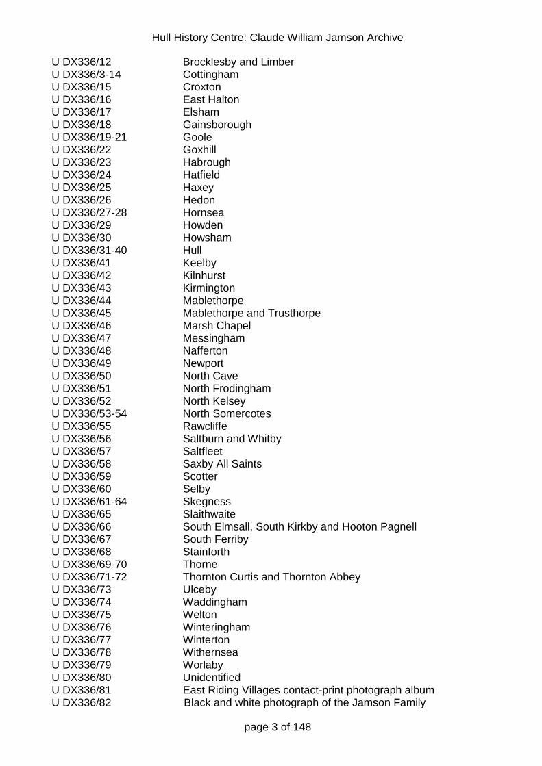
page 3 of 148
U DX336/12 Brocklesby and Limber U DX336/3-14 Cottingham U DX336/15 Croxton U DX336/16 East Halton U DX336/17 Elsham U DX336/18 Gainsborough U DX336/19-21 Goole U DX336/22 Goxhill U DX336/23 Habrough U DX336/24 Hatfield U DX336/25 Haxey U DX336/26 Hedon U DX336/27-28 Hornsea U DX336/29 Howden U DX336/30 Howsham U DX336/31-40 Hull U DX336/41 Keelby U DX336/42 Kilnhurst U DX336/43 Kirmington U DX336/44 Mablethorpe U DX336/45 Mablethorpe and Trusthorpe U DX336/46 Marsh Chapel U DX336/47 Messingham U DX336/48 Nafferton U DX336/49 Newport U DX336/50 North Cave U DX336/51 North Frodingham U DX336/52 North Kelsey U DX336/53-54 North Somercotes U DX336/55 Rawcliffe U DX336/56 Saltburn and Whitby U DX336/57 Saltfleet U DX336/58 Saxby All Saints U DX336/59 Scotter U DX336/60 Selby U DX336/61-64 Skegness U DX336/65 Slaithwaite U DX336/66 South Elmsall, South Kirkby and Hooton Pagnell U DX336/67 South Ferriby U DX336/68 Stainforth U DX336/69-70 Thorne U DX336/71-72 Thornton Curtis and Thornton Abbey U DX336/73 Ulceby U DX336/74 Waddingham U DX336/75 Welton U DX336/76 Winteringham U DX336/77 Winterton U DX336/78 Withernsea U DX336/79 Worlaby U DX336/80 Unidentified U DX336/81 East Riding Villages contact-print photograph album U DX336/82 Black and white photograph of the Jamson Family
Hull History Centre: Claude William Jamson Archive
page 4 of 148
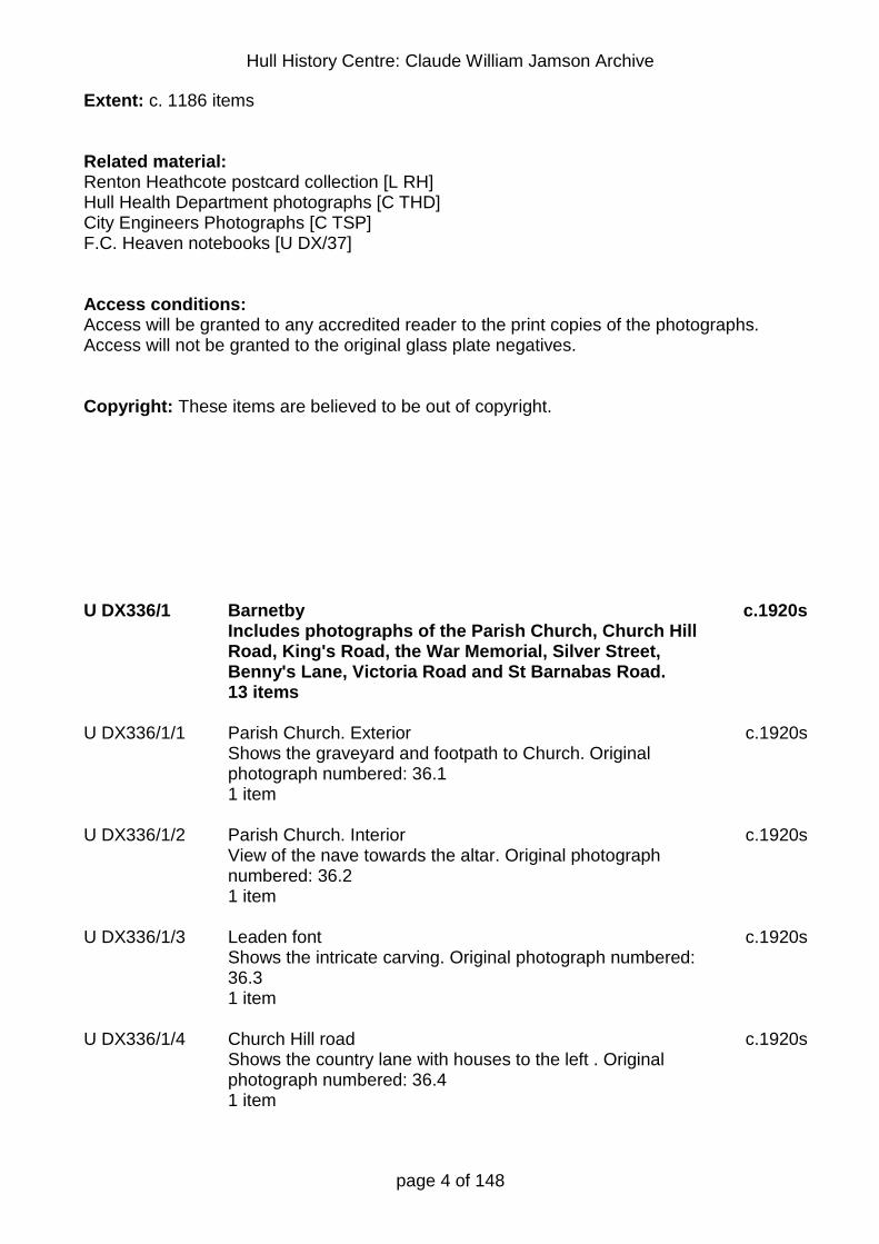
Extent: c. 1186 items Related material: Renton Heathcote postcard collection [L RH] Hull Health Department photographs [C THD] City Engineers Photographs [C TSP] F.C. Heaven notebooks [U DX/37] Access conditions: Access will be granted to any accredited reader to the print copies of the photographs. Access will not be granted to the original glass plate negatives. Copyright: These items are believed to be out of copyright. U DX336/1 Barnetby
Includes photographs of the Parish Church, Church Hill Road, King's Road, the War Memorial, Silver Street, Benny's Lane, Victoria Road and St Barnabas Road. 13 items
c.1920s
U DX336/1/1 Parish Church. Exterior Shows the graveyard and footpath to Church. Original photograph numbered: 36.1 1 item
c.1920s
U DX336/1/2 Parish Church. Interior View of the nave towards the altar. Original photograph numbered: 36.2 1 item
c.1920s
U DX336/1/3 Leaden font Shows the intricate carving. Original photograph numbered: 36.3 1 item
c.1920s
U DX336/1/4 Church Hill road Shows the country lane with houses to the left . Original photograph numbered: 36.4 1 item
c.1920s

Hull History Centre: Claude William Jamson Archive
page 5 of 148
U DX336/1/5 Kings Road Shows the street with housing on both sides, looking towards a [railway] bridge. Includes the Railway Inn. Original photograph numbered: 36.5 1 item
c.1920s
U DX336/1/6 War Memorial Shows the front of the memorial. Original photograph numbered: 36.6 1 item
c.1920s
U DX336/1/7 Silver Street Shows the street with housing on both sides. Original photograph numbered: 36.7 1 item
c.1920s
U DX336/1/8 Parish Church. Exterior Taken from the SW, includes part of the graveyard. Original photograph numbered: 36.8 1 item
c.1920s
U DX336/1/9 Bennys Lane View of the country lane with a [farm house] on the left. Original photograph numbered: 36.9 1 item
c.1920s
U DX336/1/10 Silver Street Shows the street with housing on both sides. Original photograph numbered: 36.10 1 item
c.1920s
U DX336/1/11 Victoria Road Shows the street with housing and other buildings, including a newsagent. Original photograph numbered: 36.11 1 item
c.1920s
U DX336/1/12 St Barnabas Road Includes a view of the War Memorial on the left and housing on the right of the road. Original photograph numbered: 36.12 1 item
c.1920s
U DX336/1/13 Composite view-card Includes original photographs numbered: 36.4, 5, 8, 11 and 12. Card entitled 'Greetings from Barnetby'. Original photograph un-numbered 1 item
c.1920s
Hull History Centre: Claude William Jamson Archive
page 6 of 148
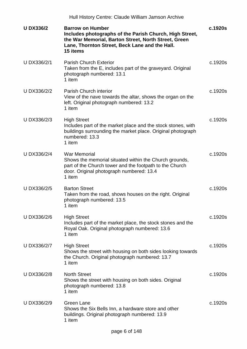
U DX336/2 Barrow on Humber Includes photographs of the Parish Church, High Street, the War Memorial, Barton Street, North Street, Green Lane, Thornton Street, Beck Lane and the Hall. 15 items
c.1920s
U DX336/2/1 Parish Church Exterior Taken from the E, includes part of the graveyard. Original photograph numbered: 13.1 1 item
c.1920s
U DX336/2/2 Parish Church interior View of the nave towards the altar, shows the organ on the left. Original photograph numbered: 13.2 1 item
c.1920s
U DX336/2/3 High Street Includes part of the market place and the stock stones, with buildings surrounding the market place. Original photograph numbered: 13.3 1 item
c.1920s
U DX336/2/4 War Memorial Shows the memorial situated within the Church grounds, part of the Church tower and the footpath to the Church door. Original photograph numbered: 13.4 1 item
c.1920s
U DX336/2/5 Barton Street Taken from the road, shows houses on the right. Original photograph numbered: 13.5 1 item
c.1920s
U DX336/2/6 High Street Includes part of the market place, the stock stones and the Royal Oak. Original photograph numbered: 13.6 1 item
c.1920s
U DX336/2/7 High Street Shows the street with housing on both sides looking towards the Church. Original photograph numbered: 13.7 1 item
c.1920s
U DX336/2/8 North Street Shows the street with housing on both sides. Original photograph numbered: 13.8 1 item
c.1920s
U DX336/2/9 Green Lane Shows the Six Bells Inn, a hardware store and other buildings. Original photograph numbered: 13.9 1 item
c.1920s

Hull History Centre: Claude William Jamson Archive
page 7 of 148
U DX336/2/10 Parish Church Exterior Taken from the S, includes the War Memorial and the Church tower. Original photograph numbered: 13.10 1 item
c.1920s
U DX336/2/11 Thornton Street Shows the street with housing on both sides. Original photograph numbered: 13.11 1 item
c.1920s
U DX336/2/12 Beck Lane Shows the [village water pump] and the lane. Original photograph numbered: 13.12 1 item
c.1920s
U DX336/2/13 Composite view card Includes original photographs numbered: 13.1, 3, 4, 9 and 11.8 Thornton Abbey. Card entitled 'Best Wishes from Barrow on Humber'. Original photograph un-numbered 1 item
c.1920s
U DX336/2/14 Composite view card Includes original photographs numbered: 13.6, 7, 8, 10 and 11.9 Thornton Abbey. Card entitled 'Greetings from Barrow on Humber'. Original photograph un-numbered 1 item
c.1920s
U DX336/2/15 The Hall View of The Hall including the tennis court. Original photograph un-numbered. 1 item
c.1920s
U DX336/3 Barton on Humber Includes photographs of the River Humber, Butts Road, the Waterside, St. Mary's Church, Brigg Road, St Peter's Church, Fleetgate, the Market Place, Tofts Road, Barrow Road, Whitecross Street and High Street. 16 items
c.1920s
U DX336/3/1 River Humber Shows a wooden pier with one docked boat, part of the foreshore and the river. Original photograph numbered: 14.1 1 item
c.1920s
U DX336/3/2 Butts Road Shows the street with houses on both sides. Original photograph numbered: 14.2 1 item
c.1920s

Hull History Centre: Claude William Jamson Archive
page 8 of 148
U DX336/3/3 Waterside View of an [old mill] and a pedestrian bridge across the [canal] . Original photograph numbered: 14.3 1 item
c.1920s
U DX336/3/4 Waterside Shows boats in the [canal] and industrial buildings on both banks. Original photograph numbered: 14.4 1 item
c.1920s
U DX336/3/5 St Mary's Church. Interior View of the nave towards the altar. Original photograph numbered: 14.5 1 item
c.1920s
U DX336/3/6 Brigg Road Taken from the road, shows houses in the distance. Original photograph numbered: 14.6 1 item
c.1920s
U DX336/3/7 St Peter's Church. Interior View of the nave towards the altar. Original photograph numbered: 14.7 1 item
c.1920s
U DX336/3/8 Waterside View of the street including 'A. Dickinson, Grocer and Provision Dealer'. Original photograph numbered: 14.8 1 item
c.1920s
U DX336/3/9 St Mary's Church. Exterior View from the E, including the village pond. Original photograph numbered: 14.9 1 item
c.1920s
U DX336/3/10 Fleetgate Shows the street with buildings on both sides. Includes the Waggon and Horses Inn and 'R. Mather, Boot and Shoe Repairs'. Original photograph numbered: 14.10 1 item
c.1920s
U DX336/3/11 Humberside View of the shore with beached boats and part of the river. Original photograph numbered: 14.11 1 item
c.1920s
U DX336/3/12 Market Place Includes the White Lion, the George Hotel, the National Provincial Bank of England and the shops 'Haslam' and '[Dawson]' . Original photograph numbered: 14.12 1 item
c.1920s

Hull History Centre: Claude William Jamson Archive
page 9 of 148
U DX336/3/13 Tofts Road View of the country lane with trees on the right. Original photograph numbered: 14.13 1 item
c.1920s
U DX336/3/14 Barrow Road Shows the street with buildings on the left and a BP petrol station. Original photograph numbered: 14.14 1 item
c.1920s
U DX336/3/15 Whitecross Street Shows buildings on both sides of the street. Includes the Volunteers Arms. Original photograph numbered: 14.15 1 item
c.1920s
U DX336/3/16 High Street View towards the Church, includes 'L. Scott, Greengrocer' and 'Wyles Bros. Ltd, The Great Boot Providers'. Original photograph numbered: 14.16 1 item
c.1920s
U DX336/4 Barton on Humber Includes photographs of Holydike Road, Ferriby Road, Whitecross Street, St Mary's Church, St Peter's Church, Ferriby Cliffs, the River Humber, High Street and Westfield Road. 19 items
c.1920s
U DX336/4/1 Holydike Road Shows houses on the left of the street. Original photograph numbered: 14.17 1 item
c.1920s
U DX336/4/2 Holydike Road Shows buildings on both sides of the street. Includes the Wheat Sheaf Inn. Original photograph numbered: 14.18 1 item
c.1920s
U DX336/4/3 Ferriby Road Taken from the road, shows a mill in the distance. Original photograph numbered: 14.19 1 item
c.1920s
U DX336/4/4 Whitecross Street Shows buildings on both sides of the street including a pub. Original photograph numbered: 14.20 1 item
c.1920s
Hull History Centre: Claude William Jamson Archive
page 10 of 148
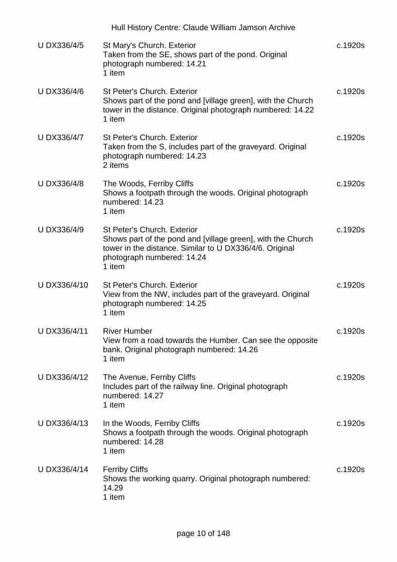
U DX336/4/5 St Mary's Church. Exterior Taken from the SE, shows part of the pond. Original photograph numbered: 14.21 1 item
c.1920s
U DX336/4/6 St Peter's Church. Exterior Shows part of the pond and [village green], with the Church tower in the distance. Original photograph numbered: 14.22 1 item
c.1920s
U DX336/4/7 St Peter's Church. Exterior Taken from the S, includes part of the graveyard. Original photograph numbered: 14.23 2 items
c.1920s
U DX336/4/8 The Woods, Ferriby Cliffs Shows a footpath through the woods. Original photograph numbered: 14.23 1 item
c.1920s
U DX336/4/9 St Peter's Church. Exterior Shows part of the pond and [village green], with the Church tower in the distance. Similar to U DX336/4/6. Original photograph numbered: 14.24 1 item
c.1920s
U DX336/4/10 St Peter's Church. Exterior View from the NW, includes part of the graveyard. Original photograph numbered: 14.25 1 item
c.1920s
U DX336/4/11 River Humber View from a road towards the Humber. Can see the opposite bank. Original photograph numbered: 14.26 1 item
c.1920s
U DX336/4/12 The Avenue, Ferriby Cliffs Includes part of the railway line. Original photograph numbered: 14.27 1 item
c.1920s
U DX336/4/13 In the Woods, Ferriby Cliffs Shows a footpath through the woods. Original photograph numbered: 14.28 1 item
c.1920s
U DX336/4/14 Ferriby Cliffs Shows the working quarry. Original photograph numbered: 14.29 1 item
c.1920s

Hull History Centre: Claude William Jamson Archive
page 11 of 148
U DX336/4/15 Composite view card Includes original photographs numbered: 14.1, 14, 16, 21, 24. Card entitled 'Greetings from Barton on Humber'. Original photograph un-numbered 1 item
c.1920s
U DX336/4/16 Composite view card Includes original photographs numbered: 14.9, 11, 15, 23 (St Peter's), 26. Card entitled 'Best Wishes from Barton on Humber'. It is badly damaged. Original photograph un-numbered 1 item
c.1920s
U DX336/4/17 High Street Shows buildings on both sides of the street. Includes the Coach and Horses. Original photograph un-numbered 1 item
c.1920s
U DX336/4/18 Westfield Road Shows buildings on both sides of the street. Original photograph un-numbered 1 item
c.1920s
U DX336/5 Beverley Includes photographs of the Minster, the War Memorial, St Mary's Church and the Westwood. 22 items
c.1920s
U DX336/5/1 Minster. Exterior from S. Shows some allotments and the full width and height of the minster. Original photograph numbered: 10.1 1 item
c.1920s
U DX336/5/2 Minster. Exterior from E Shows the minster in the distance with buildings in front. Original photograph numbered: 10.2 1 item
c.1920s
U DX336/5/3 War Memorial and St Mary's Taken from the Memorial Gardens. Original photograph numbered: 10.3 1 item
c.1920s
U DX336/5/4 St Mary's Exterior from E Includes part of the Memorial Gardens and Hengate. Original photograph numbered: 10.4 1 item
c.1920s

Hull History Centre: Claude William Jamson Archive
page 12 of 148
U DX336/5/5 Minster Nave View towards the altar, includes the organ. Original photograph numbered: 10.5 Access will be granted to any accredited reader 3 items
c.1920s
U DX336/5/6 Minster Staircase Staircase in one of the [transepts]. Original photograph numbered: 10.6 1 item
c.1920s
U DX336/5/7 Minster Exterior from S Taken from across fields, shows the full length of the Minster. Original photograph numbered: 10.7 1 item
c.1920s
U DX336/5/8 Minster Towers Taken from the NW, shows the full height of the towers. Original photograph numbered: 10.8 1 item
c.1920s
U DX336/5/9 St Mary's Exterior from S.W. Taken from across the adjacent road. Original photograph numbered: 10.9 1 item
c.1920s
U DX336/5/10 Westwood Shows a footpath across the Westwood across a small bridge. Original photograph numbered: 10.10 1 item
c.1920s
U DX336/5/11 Minster Font View towards the transepts. Original photograph numbered: 10.11 1 item
c.1920s
U DX336/5/12 War memorial Shows the full height of the memorial. Original photograph numbered: 10.12 1 item
c.1920s
U DX336/5/13 St Mary's Choir (cracked) View towards the altar, includes the full stained glass window behind. Original photograph numbered: 10.13 1 item
c.1920s
U DX336/5/14 St Mary's W. Front Taken from across the adjacent street. Original photograph numbered: 10.14 1 item
c.1920s
Hull History Centre: Claude William Jamson Archive
page 13 of 148
U DX336/5/15 St Mary's Nave View towards the altar. Original photograph numbered: 10.15 2 items
c.1920s
U DX336/5/16 Minster. Choir View towards the nave, shows the organ. Original photograph numbered: 10.16 2 items
c.1920s
U DX336/5/17 Minster. War Shrine Shows the full south side of the shrine. Original photograph numbered: 10.17 2 items
c.1920s
U DX336/6 Beverley Includes photographs of the Minster, St Mary's Church, New Walk, the Market Place and North Bar without. 19 items
c.1920s
U DX336/6/1 Minster Choir View towards the nave including the organ. Original photograph numbered: 10.18 1 item
c.1920s
U DX336/6/2 St Mary's Interior View of the nave towards the entrance. Original photograph numbered: 10.19 1 item
c.1920s
U DX336/6/3 Minster. Exterior from S Original photograph numbered: 10.20 1 item
c.1920s
U DX336/6/4 St Mary's Interior View of the nave towards the altar. Original photograph numbered: 10.21 1 item
c.1920s
U DX336/6/5 New Walk Original photograph numbered: 10.22 1 item
c.1920s
U DX336/6/6 Market Place Includes the Market Cross, John Smith's Tadcaster Brewery office, Prescott Watchmakers, [Morrisons] barbers, the Commercial Hotel, Akrill's Cycles and Stead and Simpson. Original photograph numbered: 10.23 1 item
c.1920s

Hull History Centre: Claude William Jamson Archive
page 14 of 148
U DX336/6/7 Market Place Includes the Market Cross, John Smith's Tadcaster Brewery office, Prescott Watchmakers, the Commercial Hotel, Akrill's Cycles and other shops. . Original photograph numbered: 10.24 1 item
c.1920s
U DX336/6/8 North Bar from without Shows the North Bar and the neighbouring houses. Original photograph numbered: 10.25 1 item
c.1920s
U DX336/6/9 Minster Choir View towards the altar. Original photograph numbered: 10.26 1 item
c.1920s
U DX336/6/10 Minster Screen and South Transept Original photograph numbered: 10.27 1 item
c.1920s
U DX336/6/11 Minster Percy Shrine Original photograph numbered: 10.28 1 item
c.1920s
U DX336/6/12 Minster East Window Original photograph numbered: 10.29 2 items
c.1920s
U DX336/6/13 Minster Interior View of the nave towards the west entrance. Original photograph numbered: 10.30 1 item
c.1920s
U DX336/6/14 Composite view card Includes original photographs numbered: 10.9, 18, 22, 23, 25. Card entitled 'Greetings from Beverley'. Original photograph un-numbered 1 item
c.1920s
U DX336/6/15 Minster. Sanctuary chair Original photograph un-numbered 3 items
c.1920s
U DX336/6/16 St Mary's Danish soldiers' monument The writing on the plaque is readable. Original photograph un-numbered 1 item
c.1920s
Hull History Centre: Claude William Jamson Archive
page 15 of 148
U DX336/7 Binbrooke Includes photographs of the Parish Church, High Street, the Market Place, the War Memorial, the old mill, Granby Lane, Louth Road and the 'Marquis of Granby'. 22 items
c.1920s
U DX336/7/1 Parish Church Interior View of the nave towards the altar. Original photograph numbered: 35.1 1 item
c.1920s
U DX336/7/2 High Street and Market Place View towards the Market Place from the High Street. Original photograph numbered: 35.2 1 item
c.1920s
U DX336/7/3 War memorial Situated in the grounds of the Church facing towards the Church tower. Original photograph numbered: 35.3 3 items
c.1920s
U DX336/7/4 Parish Church Exterior View from the SE taken from across the adjacent road, includes part of the graveyard. Original photograph numbered: 35.4 1 item
c.1920s
U DX336/7/5 Market Place View towards the Market Place. There are buildings on the left including the Plough Inn. Original photograph numbered: 35.5 2 items
c.1920s
U DX336/7/6 The old mill Taken from across a fence and field towards the mill in the distance. Original photograph numbered: 35.6 1 item
c.1920s
U DX336/7/7 Market Place Shows the water pump and central sign post as well as some of the buildings around the Market Place. Original photograph numbered: 35.7 1 item
c.1920s
U DX336/7/8 Granby Lane Includes the Marquis of Granby Inn on the right and other houses in the distance. Original photograph numbered: 35.8 3 items
c.1920s

Hull History Centre: Claude William Jamson Archive
page 16 of 148
U DX336/7/9 Louth Road View of the Church from SE. Taken from the road, shows houses on the left and in the distance past the Church. Original photograph numbered: 35.9 1 item
c.1920s
U DX336/7/10 'Marquis of Granby' The Inn is the main focus of the photograph. Original photograph numbered: 35.10 2 items
c.1920s
U DX336/7/11 Market Place Shows the water pump and central sign post with the old mill in the distance and the [Methodist chapel] on the left of the Market Place. Original photograph numbered: 35.11 1 item
c.1920s
U DX336/7/12 High Street Shows the High Street with housing on both sides with some shop fronts. Original photograph numbered: 35.12 2 items
c.1920s
U DX336/7/13 Parish Church Exterior View from the W, taken from the lane to the Church. Original photograph numbered: 35.13 1 item
c.1920s
U DX336/7/14 Composite view card Includes original photographs numbered: 35.2, 6, 7, 9, 11. Card entitled 'Greetings from Binbrooke'. Original photograph un-numbered 1 item
c.1920s
U DX336/7/15 With picture postcards from 35.1, 2, 4-9, 11-13 and the view card There are no photographic copies of these glass plate negatives. 1 item
c.1920s

Hull History Centre: Claude William Jamson Archive
page 17 of 148
U DX336/8 Bridlington Includes photographs of donkeys on the beach, the Floral Staircase, the Bayle Gate, the Alexandra Hotel, the Floral Clock, the Spa, the Harbour, the Floral Hall, the promenade and new shelter, Sewerby Cliffs and the beach. 12 items
c.1920s
U DX336/8/1 Donkeys on sands Entitled 'Now for a jolly ride at Bridlington', shows a child taking a donkey ride, with the promenade in the background. Original photograph numbered: 40.1 2 items
c.1920s
U DX336/8/2 Floral Staircase The staircase is the main focus of the photograph with some houses in the background. Original photograph numbered: 40.2 1 item
c.1920s
U DX336/8/3 Bayle Gate Taken from the road to the gate, shows the top of a church tower to the left of the gate. Original photograph numbered: 40.3 1 item
c.1920s
U DX336/8/4 Alexandra Hotel Includes the Rockville and other buildings to both sides of the hotel. Taken from the direction of the promenade. Original photograph numbered: 40.4 1 item
c.1920s
U DX336/8/5 Floral clock Taken from the pavement with the clock as the main focus of the photograph. Original photograph numbered: 40.5 1 item
c.1920s
U DX336/8/6 The Spa Includes a view of the beach in the background and the houses overlooking the beach. Original photograph numbered: 40.6 1 item
c.1920s
U DX336/8/7 The Harbour Shows a pleasure boat in dock and parts of the harbour walls. Original photograph numbered: 40.7 1 item
c.1920s
U DX336/8/8 Floral Hall. Interior Shows band playing on the band stand and the seating. Original photograph numbered: 40.8 1 item
c.1920s

Hull History Centre: Claude William Jamson Archive
page 18 of 148
U DX336/8/9 Promenade View towards Sewerby Cliffs in the background. Original photograph numbered: 40.9 2 items
c.1920s
U DX336/8/10 New shelter and promenade View towards Sewerby Cliffs in the background, includes part of the beach. Original photograph numbered: 40.10 2 items
c.1920s
U DX336/8/11 Sewerby cliffs View towards Sewerby showing the cliff side path. Original photograph numbered: 40.11 1 item
c.1920s
U DX336/8/12 The Sands Taken on a busy day, includes part of the promenade. View towards Sewerby Cliffs in the background. Original photograph numbered: 40.12 2 items
c.1920s
U DX336/9 Bridlington Includes photographs of the Floral Clock, the Floral Hall, the Priory Church, the terraces, Victoria Terraces, Princes Parade, the Harbour, the promenade, children paddling and the Beaconsfield Gardens. 24 items
c.1920s
U DX336/9/1 Floral Clock and Floral Hall Shows the Floral Hall to the right of the clock with other buildings behind. Original photograph numbered: 40.13 4 items
c.1920s
U DX336/9/2 Priory Church Exterior Shows part of the graveyard. Taken from the [SW]. Original photograph numbered: 40.14 2 items
c.1920s
U DX336/9/3 The Terraces Taken on a busy day, shows part of the terraces, the promenade and the beach. View towards Sewerby Cliffs in the distance. Original photograph numbered: 40.15 2 items
c.1920s
U DX336/9/4 Victoria Terraces Taken on a busy day, shows part of the terraces, the promenade and the beach. View towards Sewerby Cliffs in the distance. Original photograph numbered: 40.16 2 items
c.1920s
Hull History Centre: Claude William Jamson Archive
page 19 of 148
U DX336/9/5 Princes Parade Includes the Floral Clock and Floral Hall. View towards Sewerby Cliffs in the distance. Original photograph numbered: 40.17 2 items
c.1920s
U DX336/9/6 The Harbour Shows a steam boat outside the harbour and smaller vessels within the harbour. Includes parts of the harbour walls. Original photograph numbered: 40.18 1 item
c.1920s
U DX336/9/7 The Promenade Shows the promenade and the beach. Includes Beaconsfield House. View towards Sewerby Cliffs in the distance. Original photograph numbered: 40.19 1 item
c.1920s
U DX336/9/8 Priory Church Interior View of the nave towards the altar. Original photograph numbered: 40.20 2 items
c.1920s
U DX336/9/9 Royal Princes Parade Includes the Floral Clock and Floral Hall. View towards Sewerby Cliffs in the distance. Original photograph numbered: 40.21 2 items
c.1920s
U DX336/9/10 Paddling View towards Sewerby Cliffs in the distance. Shows part of the promenade and includes Beaconsfield House. Taken on a busy day. Original photograph numbered: 40.22 1 item
c.1920s
U DX336/9/11 Paddling View towards Sewerby Cliffs in the distance. Shows part of the promenade and includes Beaconsfield House. Taken on a busy day. Original photograph numbered: 40.22 1 item
c.1920s
U DX336/9/12 Princes Parade Includes the Floral Clock and Floral Hall. View towards Sewerby Cliffs in the distance. Original photograph numbered: 40.24 1 item
c.1920s
U DX336/9/13 Beaconsfield Gardens and Promenade Includes Beaconsfield House and part of the promenade and beach. View towards Sewerby Cliffs in the distance. Original photograph numbered: 40.25 2 items
c.1920s
Hull History Centre: Claude William Jamson Archive
page 20 of 148
U DX336/9/14 Terraces and sands Includes part of the terraces and the beach. View towards the harbour walls. Original photograph numbered: 40.26 1 item
c.1920s
U DX336/10 Brigg Includes photographs of Wrawby Street, the River Ancholme, Bigby Street, the Market Place, Bridge Street, the Old Bridge and the Junction. 19 items
c.1920s
U DX336/10/1 Wrawby Street Shows the street with housing on both sides. Includes a BP Garage and a village pub. Original photograph numbered: 45.1 4 items
c.1920s
U DX336/10/2 River Ancholme (Cracked) Includes the County Bridge (1828) and Spring and Co building. Shows buildings on both sides of the river and a group of boys rowing. Original photograph numbered: 45.2 1 item
c.1920s
U DX336/10/3 River Ancholme (Broken) There is no photographic copy of this glass plate negative. Original photograph numbered: 45.3 1 item
c.1920s
U DX336/10/4 Bigby Street Looking towards the Church, includes a car hire shop. Shows the street with buildings on both sides Original photograph numbered: 45.4 2 items
c.1920s
U DX336/10/5 Market Place Taken on a busy market day showing the stalls as well as a Fish and Chip Shop, J.R. Whelpton Garage and Motors and the National Provincial Bank. Original photograph numbered: 45.5 1 item
c.1920s
U DX336/10/6 Bigby Road View towards the War Memorial with housing on both sides of the road. Original photograph numbered: 45.6 1 item
c.1920s
U DX336/10/7 Bridge Street Taken from the road showing houses in both sides of the street. Original photograph numbered: 45.7 1 item
c.1920s

Hull History Centre: Claude William Jamson Archive
page 21 of 148
U DX336/10/8 Bridge Street Includes a newsagent and other shops. Shows lots of traffic in the street including a bus. Original photograph numbered: 45.8 1 item
c.1920s
U DX336/10/9 Old Bridge The County Bridge (1828), also includes the Nelthorpe Arms in the distance. Original photograph numbered: 45.9 1 item
c.1920s
U DX336/10/10 The Junction Includes the War Memorial. Shows the various roads off the junction. Original photograph numbered: 45.10 1 item
c.1920s
U DX336/10/11 Bigby Road Looking towards the Church. Shows housing on the left side of the street. Original photograph numbered: 45.11 1 item
c.1920s
U DX336/10/12 River Ancholme Looking towards the County Bridge, shows a ship docked on the left. Includes Spring and Co. Limited building. Original photograph numbered: 45.12 1 item
c.1920s
U DX336/10/13 Wrawby Street Shows buildings on both sides of the street. Includes the Butchers Arms Inn and Dunn and Sons. Original photograph numbered: 45.13 1 item
c.1920s
U DX336/10/14 River Ancholme Looking towards the County Bridge, shows some boats on the river. Original photograph numbered: 45.14 1 item
c.1920s
U DX336/10/15 Wrawby Street Includes the War Memorial. Original photograph numbered: 45.15 1 item
c.1920s

Hull History Centre: Claude William Jamson Archive
page 22 of 148
U DX336/11 Brigg Includes photographs of the Grammar School, the Infirmary, the War Memorial and the Gull Ponds. 13 items
c.1920s
U DX336/11/1 Grammar School Shows one of the sides of the school. Original photograph numbered: 45.16 2 items
c.1920s
U DX336/11/2 Grammar School Shows the [front] entrance of the school. Original photograph numbered: 45.17 1 item
c.1920s
U DX336/11/3 The Infirmary Taken from a lawn outside the front of the infirmary. Original photograph numbered: 45.18 1 item
c.1920s
U DX336/11/4 The Gull Ponds Scawby Birds in flight. Original photograph numbered: 45.20 1 item
c.1920s
U DX336/11/5 The Gull Ponds Scawby Birds in flight. Original photograph numbered: 45.21 1 item
c.1920s
U DX336/11/6 The Gull Ponds Scawby Gull's nest with gull chick and eggs. Original photograph numbered: 45.22 2 items
c.1920s
U DX336/11/7 The Gull Ponds Scawby Birds in flight. Original photograph numbered: 45.23 1 item
c.1920s
U DX336/11/8 The Gull Ponds Scawby Birds in flight. Original photograph numbered: 45.24 Access will be granted to any accredited reader 1 item
c.1920s
U DX336/11/9 The Gull Ponds Scawby Original photograph numbered: 45.25 1 item
c.1920s
U DX336/11/10 Composite view card Includes original photographs numbered: 45.3, 5, 8, 10, 11. There is no photographic copy of this glass plate negative. Original photograph un-numbered 1 item
c.1920s
Hull History Centre: Claude William Jamson Archive
page 23 of 148
U DX336/11/11 War Memorial Shows the memorial with buildings behind. Both the lions on the memorial are visible. Original photograph un-numbered 1 item
c.1920s
U DX336/12 Brocklesby and Limber Includes photographs of the Brocklesby Hall estate, the Parish Church and the Vicarage at Limber. 17 items
c.1920s
U DX336/12/1 The mausoleum. Brocklesby Park Original photograph numbered: 56.1 2 items
c.1920s
U DX336/12/2 Brocklesby Shows a country road with houses on the left. Original photograph numbered: 56.2 1 item
c.1920s
U DX336/12/3 Brocklesby Hall Lodge Gates Side view of the gates, taken from grass in front of the gates. Original photograph numbered: 56.3 1 item
c.1920s
U DX336/12/4 The Gateway Brocklesby Park Shows the road leading to the gateway, with buildings visible through the arch. Original photograph numbered: 56.4 2 items
c.1920s
U DX336/12/5 The Walk Shows a country lane leading away from a gate towards a house in the distance. Original photograph numbered: 56.5 1 item
c.1920s
U DX336/12/6 Brocklesby A similar image to U DX336/12/2, take from slightly further back. Original photograph numbered: 56.6 1 item
c.1920s
U DX336/12/7 Brocklesby Shows an ivy covered house, known as [The Gardener's House]. Original photograph un-numbered 1 item
c.1920s
U DX336/12/8 The Kennels Taken from the lawns in front of The Kennels. Original photograph un-numbered 1 item
c.1920s

Hull History Centre: Claude William Jamson Archive
page 24 of 148
U DX336/12/9 Parish Church View taken from the N, shows the lane leading to the Church. Original photograph un-numbered 1 item
c.1920s
U DX336/12/10 The Lodge Shows the front entrance of the lodge. Original photograph un-numbered 1 item
c.1920s
U DX336/12/11 The Vicarage Taken from the lawns towards the vicarage. Original photograph numbered: 61.3 1 item
c.1920s
U DX336/12/12 Vicarage Gardens View towards the Church taken from the gardens. Original photograph numbered: 61.4 1 item
c.1920s
U DX336/12/13 Limber Includes a country lane and a large house on the right. Original photograph numbered: 61.5 1 item
c.1920s
U DX336/12/14 Limber View towards the Church from across some fields. Shows a small part of the graveyard and an adjacent lane. Original photograph numbered: 61.7 1 item
c.1920s
U DX336/12/15 Mausoleum Gates Taken from the lane leading towards the gates. Original photograph numbered: 61.8 1 item
c.1920s
U DX336/13 Cottingham Includes photographs of the Parish Church, the Beck, Hallgate, Southgate, Northgate, the Sanatorium, Southwood Road and Finkle Street. 15 items
c.1920s
U DX336/13/1 Parish Church Interior View of the nave looking towards the altar. Original photograph numbered: 52.1 1 item
c.1920s
U DX336/13/2 The Beck Looking towards a bridge with houses behind. Original photograph numbered: 52.2 1 item
c.1920s

Hull History Centre: Claude William Jamson Archive
page 25 of 148
U DX336/13/3 Parish Church Exterior Taken from the gates into the graveyard. Original photograph numbered: 52.3 1 item
c.1920s
U DX336/13/4 Hallgate Looking towards the Church, includes the shop A. Barker, William Cussons Ltd and Midland Bank Ltd. Shows buildings on both sides of the street. Original photograph numbered: 52.4 1 item
c.1920s
U DX336/13/5 Southgate Shows the street with housing on both sides. Original photograph numbered: 52.5 1 item
c.1920s
U DX336/13/6 Northgate Shows the street with housing on both sides with some shop fronts. Original photograph numbered: 52.6 1 item
c.1920s
U DX336/13/7 The Sanatorium Taken from the grounds looking towards the sanatorium with some out-buildings in the distance. Original photograph numbered: 52.7 1 item
c.1920s
U DX336/13/8 The Sanatorium Taken from the grounds towards some out-buildings with the sanatorium behind. Original photograph numbered: 52.8 1 item
c.1920s
U DX336/13/9 Hallgate Shows the street with buildings on both sides. Original photograph numbered: 52.9 1 item
c.1920s
U DX336/13/10 Cottingham Estate (Council houses in Southwood Road) There is no photographic copy of this glass plate negative. Original photograph numbered: 52.02 1 item
c.1920s
U DX336/13/11 Hallgate Shows the street with buildings on the right. Original photograph un-numbered 1 item
c.1920s
U DX336/13/12 Southgate Shows the street with houses on the left and part of the road. Original photograph un-numbered 1 item
c.1920s

Hull History Centre: Claude William Jamson Archive
page 26 of 148
U DX336/13/13 Southwood Road Shows the street with houses on the left and part of the road. Original photograph un-numbered 1 item
c.1920s
U DX336/13/14 Finkle Street Shows the street with buildings on both sides. Original photograph un-numbered 1 item
c.1920s
U DX336/13/15 Northgate Shows the street with buildings on both sides. Original photograph un-numbered 1 item
c.1920s
U DX336/14 Cottingham Includes photographs of Thwaite Street, King Street, the Green, the Parish Church, Beck Bank, New Village Road, Northgate, Woods Lane, Harland Way, Newgate and West Green. 18 items
c.1920s
U DX336/14/1 Thwaite Street Taken from the street. Shows buildings on the left, including the Railway Hotel. Original photograph numbered: 52.10 1 item
c.1920s
U DX336/14/2 King Street and Green Includes the Duke of Cumberland pub and a cinema. Original photograph numbered: 52.11 1 item
c.1920s
U DX336/14/3 Parish Church Exterior Shows part of the graveyard and the full height of the tower. Original photograph numbered: 52.12 1 item
c.1920s
U DX336/14/4 Beck Bank Shows part of the beck and the adjacent road. Original photograph numbered: 52.13 1 item
c.1920s
U DX336/14/5 New Village Road Shows the street with buildings on both sides. Looking towards the railway crossing. Original photograph numbered: 52.19 2 items
c.1920s
Hull History Centre: Claude William Jamson Archive
page 27 of 148
U DX336/14/6 Northgate Shows the street with buildings on both sides. Original photograph numbered: 52.21 2 items
c.1920s
U DX336/14/7 Woods Lane Taken from the lane, shows houses on the left and houses on an unseen street to the right. Original photograph numbered: 52.23 1 item
c.1920s
U DX336/14/8 Harland Way Shows houses on the right of the street. Original photograph un-numbered 1 item
c.1920s
U DX336/14/9 Newgate Shows buildings to the left of the road and driveways for houses on the right. Original photograph un-numbered 2 items
c.1920s
U DX336/14/10 West Green Taken from the green, shows part of the green and some of the surrounding buildings. Original photograph un-numbered 2 items
c.1920s
U DX336/14/11 Green (damaged) Includes the Duke of Cumberland pub. Original photograph un-numbered 2 items
c.1920s
U DX336/14/12 Composite view card Includes original photographs numbered: 52.3, 4, 5, 10, 11. Card entitled 'Greetings from Cottingham'. Original photograph un-numbered 1 item
c.1920s
U DX336/14/13 Composite view card Includes original photographs numbered: 52.3, 4, 5, 6, 11. Card entitled 'Greetings from Cottingham'. Original photograph un-numbered 1 item
c.1920s

Hull History Centre: Claude William Jamson Archive
page 28 of 148
U DX336/15 Croxton Includes photographs of Croxton House, The Beeches and the Parish Church. 8 items
c.1920s
U DX336/15/1 Croxton View across [pasture] towards the Church. Includes some buildings in front of the Church and to the left. Original photograph numbered: 2 1 item
c.1920s
U DX336/15/2 Croxton House Taken from the road leading towards the house. Original photograph numbered: 3 1 item
c.1920s
U DX336/15/3 Croxton Looking towards the Church in the distance from a lane with houses to the left. Original photograph numbered: 4 1 item
c.1920s
U DX336/15/4 Croxton Shows a house on the right of a road with the top of the Church tower just visible in the distance. Original photograph numbered: 6 1 item
c.1920s
U DX336/15/5 Croxton View of the lane next to the Church, with the Church on the left. Original photograph numbered: 7 1 item
c.1920s
U DX336/15/6 The Beeches Taken from across the road adjacent to the house. Original photograph numbered: 8 1 item
c.1920s
U DX336/15/7 Parish Church Exterior Taken from the lane leading to the Church, shows the Church porch. Original photograph un-numbered 1 item
c.1920s
U DX336/15/8 Tulip Time Tulip garden and sun dial. Original photograph un-numbered 1 item
c.1920s

Hull History Centre: Claude William Jamson Archive
page 29 of 148
U DX336/16 East Halton Includes photographs of the railway station, St Peter's Church and various other views of East Halton. 17 items
c.1920s
U DX336/16/1 East Halton Taken from a lane opposite the shop G.W. Cook. Original photograph numbered: 12.1 1 item
c.1920s
U DX336/16/2 Railway Station Entitled 'A Few Lines from East Halton', shows parts of both station platforms. Looking towards a bridge across the railway. Original photograph numbered: 12.2 1 item
c.1920s
U DX336/16/3 St Peter's Parish Church and lych-gate Taken from the road opposite the gate. Shows part of the graveyard. Original photograph numbered: 12.3 1 item
c.1920s
U DX336/16/4 St Peter's Parish Church Interior View of the nave towards the altar. Original photograph numbered: 12.4 1 item
c.1920s
U DX336/16/5 St Peter's Parish Church Exterior Taken from the SE. Shows part of the graveyard. Original photograph numbered: 12.5 1 item
c.1920s
U DX336/16/6 East Halton Shows a junction of country lanes with some houses on both sides. Original photograph numbered: 12.6 1 item
c.1920s
U DX336/16/7 East Halton Taken looking down a road with buildings on both sides. Original photograph numbered: 12.7 1 item
c.1920s
U DX336/16/8 St Peter's Parish Church Exterior Taken from the NW. Shows part of the graveyard. Original photograph numbered: 12.8 1 item
c.1920s
U DX336/16/9 East Halton Taken looking down a road with buildings on both sides. Original photograph numbered: 12.9 1 item
c.1920s
Hull History Centre: Claude William Jamson Archive
page 30 of 148
U DX336/16/10 East Halton Taken looking down a road with buildings on both sides. Same road as in U DX336/16/7. Includes the shop J.B. Brown. Original photograph numbered: 12.10 1 item
c.1920s
U DX336/16/11 East Halton Taken looking down a road with a house to the left and other buildings in the distance. Original photograph numbered: 12.11 1 item
c.1920s
U DX336/16/12 East Halton Shows buildings on both sides of a street. Includes the Black Bull Inn. Original photograph numbered: 12.12 1 item
c.1920s
U DX336/16/13 East Halton Shows a country lane with buildings on the right. Original photograph numbered: 12.13 1 item
c.1920s
U DX336/16/14 Composite view cards Includes original photographs numbered: 12.2, 3, 7, 13 and 11.18 (Thornton Abbey). Card entitled 'Best Wishes from East Halton'. Original photograph un-numbered 1 item
c.1920s
U DX336/16/15 Composite view cards Includes original photographs numbered: 12.1, 6, 8, 9, 11. Card entitled 'Greetings from East Halton'. Original photograph un-numbered 1 item
c.1920s
U DX336/16/16 Two snap shots Taken at the coast, possibly of the photographer's family. Original photograph un-numbered Access will be granted to any accredited reader 2 items
c.1920s
U DX336/17 Elsham Includes photographs of Elsham Hall, the Parish Church, the Schools, the Vicarage, the Thatched Cottage and the War Memorial. 10 items
c.1920s
U DX336/17/1 Lodge Gates Shows the lane leading towards the gates with houses behind. Original photograph numbered: 29.1 1 item
c.1920s

Hull History Centre: Claude William Jamson Archive
page 31 of 148
U DX336/17/2 Parish Church Exterior Taken from the W. Shows part of the graveyard. Original photograph numbered: 29.2 1 item
c.1920s
U DX336/17/3 The Schools Taken from the gardens in front of the school. Original photograph numbered: 29.3 1 item
c.1920s
U DX336/17/4 Elsham Shows an unnamed street with houses on both sides. Original photograph numbered: 29.4 1 item
c.1920s
U DX336/17/5 The Vicarage View from the gardens across the tennis court to the vicarage. Original photograph numbered: 29.5 1 item
c.1920s
U DX336/17/6 Elsham Shows a country lane with a house to the left. Original photograph numbered: 29.6 1 item
c.1920s
U DX336/17/7 The Thatched Cottage Includes the cottage and the adjacent road. Original photograph numbered: 29.7 1 item
c.1920s
U DX336/17/8 Elsham Hall View across the gardens towards the hall. Original photograph numbered: 29.8 1 item
c.1920s
U DX336/17/9 Parish Church and War Memorial View of the clock tower and the lane adjacent to the church. Original photograph numbered: 29.9 1 item
c.1920s
U DX336/17/10 Composite view card Includes original photographs numbered: 29.1, 2, 4, 7, 8. Card entitled 'Greetings from Elsham'. Original photograph un-numbered 1 item
c.1920s

Hull History Centre: Claude William Jamson Archive
page 32 of 148
U DX336/18 Gainsborough Includes photographs of the Pillared House, Church Street, Silver Street, the Parish Church, the Old Bridge, the River Trent, Morton Corner, the Toll Bridge, the Water Tower, the Market Place, the Old Hall, the War Memorial, Hawthorne Avenue and Thornock Lodge. 19 items
c.1920s
U DX336/18/1 The Pillared House Shows buildings on both sides of the street with the Pillared House on the left. Includes a confectionary shop, on the ground floor of the Pillared House, and the Wheat Sheaf Inn. Original photograph numbered: 38.1 1 item
c.1920s
U DX336/18/2 Church Street Shows several shop fronts to the left of the street. Original photograph numbered: 38.2 1 item
c.1920s
U DX336/18/3 Silver Street Shows several shop fronts, on both sides of the street, including His Master's Voice, Lloyd's Bank Limited and Middleton and Sons. Original photograph numbered: 38.3 1 item
c.1920s
U DX336/18/4 Parish Church Interior View of the nave towards the altar. Original photograph numbered: 38.4 1 item
c.1920s
U DX336/18/5 Old Bridge Looking towards the bridge from the riverbank. Original photograph numbered: 38.5 1 item
c.1920s
U DX336/18/6 River Trent Shows boats and barges on the river, including the Krooman. Original photograph numbered: 38.6 1 item
c.1920s
U DX336/18/7 Morton Corner Shows some buildings to the left of the river on the bank. Original photograph numbered: 38.7 1 item
c.1920s
U DX336/18/8 The Pillared House Similar to U DX336/18/1. Includes a confectionary shop, on the ground floor of the Pillard House, and the Wheat Sheaf Inn. Original photograph numbered: 38.8 1 item
c.1920s

Hull History Centre: Claude William Jamson Archive
page 33 of 148
U DX336/18/9 Toll Bridge Includes the road leading to the toll house. Original photograph numbered: 38.9 1 item
c.1920s
U DX336/18/10 Water Tower Taken from the road adjacent to the tower. The full height of the tower is visible. Original photograph numbered: 38.10 1 item
c.1920s
U DX336/18/11 Market Place Taken on market day, shows the shops of Boots the Chemists, Barrow's the Grocers and Shipley & Co Ltd. Original photograph numbered: 38.11 1 item
c.1920s
U DX336/18/12 The Old Hall and War Memorial View of the Old Hall with the memorial in front. Original photograph numbered: 38.12 1 item
c.1920s
U DX336/18/13 Parish Church Exterior Taken from the S. The full church is visible. Original photograph numbered: 38.13 1 item
c.1920s
U DX336/18/14 Market Street Shows buildings on both sides of the street, including the Marquis of Granby Hotel and Platt's Cash Store. Original photograph numbered: 38.14 1 item
c.1920s
U DX336/18/15 Hawthorne Avenue Looking towards the avenue with houses on both sides of the street. Original photograph numbered: 38.15 1 item
c.1920s
U DX336/18/16 Old Bridge Taken from the riverbank towards the bridge. Original photograph numbered: 38.16 1 item
c.1920s
U DX336/18/17 Thornock Lodge Taken from the road adjacent to the lodge. Original photograph numbered: 38.17 1 item
c.1920s
U DX336/18/18 River Trent Shows boats and barges on the river with buildings on both banks in the distance. Original photograph numbered: 38.18 1 item
c.1920s
Hull History Centre: Claude William Jamson Archive
page 34 of 148
U DX336/18/19 Market Place Shows some of the buildings surrounding the market, including the shop Mottershalls tobacconist. Original photograph numbered: 38.19 1 item
c.1920s
U DX336/19 Goole Includes photographs of the Ouse Dock, Aldam Dock, Railway Dock, Hook Road, the Lock, Stanhope Dock, the Water Towers, the Memorial Clock Tower, Marshfield Road and the Riverside Park. 13 items
c.1920s
U DX336/19/1 Coal Hoist, Ouse Dock Shows the [Shokland] in dock being loaded with coal. Original photograph numbered: 2 1 item
c.1920s
U DX336/19/2 Coal Hoist Ouse Dock Shows the [Broomfleet] in dock being loaded with coal. Original photograph numbered: 2 1 item
c.1920s
U DX336/19/3 Coal Hoist Aldam Dock Shows a ship in dock at the coal hoist. Original photograph numbered: 3 1 item
c.1920s
U DX336/19/4 Railway Dock Entrance Shows three ships in dock with surrounding [warehouses]. Original photograph un-numbered 1 item
c.1920s
U DX336/19/5 Railway Dock Entrance Shows ships and barges in dock with surrounding [warehouses]. Original photograph un-numbered 1 item
c.1920s
U DX336/19/6 Hook Road Taken from the road, looking down the street. Shows a line of houses on the left and two rows of trees bordering the road. Original photograph un-numbered 1 item
c.1920s
U DX336/19/7 The Lock Shows a ship [approaching] the lock with dock buildings behind. Original photograph un-numbered. 1 item
c.1920s

Hull History Centre: Claude William Jamson Archive
page 35 of 148
U DX336/19/8 Stanhope and Railway Docks Shows the [Nieuw Cappelle] and other ships in dock. Includes some dock [warehouses] in the distance. Original photograph un-numbered 1 item
c.1920s
U DX336/19/9 Water Towers Shows the two main water towers behind a passing cargo train. Original photograph un-numbered 1 item
c.1920s
U DX336/19/10 Memorial Clock Tower Taken from the [square] in front of the clock tower. Original photograph un-numbered 1 item
c.1920s
U DX336/19/11 Marshfield Road Taken from the road, shows a row of houses on the left. Original photograph un-numbered 1 item
c.1920s
U DX336/19/12 Two negatives of Riverside park Shows the lawns and footpaths in the park, looking towards houses [outside] of the park. Original photograph un-numbered 2 items
c.1920s
U DX336/20 Goole Includes photographs of the docks, Riverside Park, Hook Road, the Secondary School and the Water Towers. 5 items
c.1920s
U DX336/20/1 The Docks Shows the ship [Dicky] in dock and the water towers in the background and a passing cargo train. Original photograph numbered: 30 1 item
c.1920s
U DX336/20/2 Riverside Park Shows the [bandstand] being repaired and some of the lawns and footpaths. Includes a small water fountain. Original photograph numbered: 31 1 item
c.1920s
U DX336/20/3 Hook Road Taken from the side of the road, looking down the street. Shows houses on the left. Includes a World War One tank in some parkland next to the road. Original photograph numbered: 32 1 item
c.1920s

Hull History Centre: Claude William Jamson Archive
page 36 of 148
U DX336/20/4 Secondary School Taken from the lawns looking towards the main school buildings and the entrance. Original photograph numbered: 33 1 item
c.1920s
U DX336/20/5 The Water Towers Looking towards the towers, shows the back of a train approaching the towers. Original photograph numbered: 34 1 item
c.1920s
U DX336/21 Goole Includes photographs of the docks, Boothferry Road, Ship Dock, Carlisle Street, the War Memorial, the Secondary School, the riverside, West Park and Airmyn Road. 16 items
c.1920s
U DX336/21/1 Goole Docks Shows several ships in dock and one of the coal hoists. Original photograph numbered: 32.1 1 item
c.1920s
U DX336/21/2 Goole Docks Shows several ships in dock and some of the dock warehouses. A church spire can be seen beyond the dock. Original photograph numbered: 32.2 Access will be granted to any accredited reader 1 item
c.1920s
U DX336/21/3 Boothferry Road Taken from the pavement, looking down the street. Shows buildings and shops on both sides, including the Station Hotel and the shop Millards. Original photograph numbered: 32.3 1 item
c.1920s
U DX336/21/4 Boothferry Road Taken from the pavement, looking down the street. Shows buildings on both sides, including Trinity Methodist Church. Original photograph numbered: 32.4 1 item
c.1920s
U DX336/21/5 Ship Dock Shows several ships in dock including the Nina as well as one of the coal hoists. A church spire can be seen behind the coal hoist. Original photograph numbered: 32.5 1 item
c.1920s
Hull History Centre: Claude William Jamson Archive
page 37 of 148
U DX336/21/6 Carlisle Street Taken from a junction with another street, shows buildings and shops on both sides of the road including the Yorkshire Penny Bank, the Conservative Club and Fawbert Printing Works. Original photograph numbered: 32.6 1 item
c.1920s
U DX336/21/7 Boothferry Road Shows several shop fronts on both sides of the street, looking towards the Billiard Hall. Original photograph numbered: 32.7 1 item
c.1920s
U DX336/21/8 Goole Docks Shows several ships in dock and includes one of the coal hoists. There is a church spire visible in the distance. Original photograph numbered: 32.8 1 item
c.1920s
U DX336/21/9 Goole Docks Shows several ships in dock and one of the water towers in the background. Original photograph numbered: 32.9 2 items
c.1920s
U DX336/21/10 War Memorial and Secondary School View towards the school taken from the gardens surrounding the memorial. Original photograph numbered: 32.10 1 item
c.1920s
U DX336/21/11 Riverside Looking towards the town, includes one of the coal hoists. Shows the wooden walkway at the edge of the river. Original photograph numbered: 32.11 1 item
c.1920s
U DX336/21/12 Flower Time West Park Taken looking across flowerbeds and lawns towards the bandstand in the distance. There is a shelter on the left of the photograph.Original photograph numbered: 32.12 1 item
c.1920s
U DX336/21/13 The Rockery West Park Taken looking across the rockery towards the bandstand. Original photograph numbered: 32.13 1 item
c.1920s
U DX336/21/14 Airmyn Road Taken from a junction with another road. Shows houses on both sides of the junction. Original photograph numbered: 32.14 1 item
c.1920s

Hull History Centre: Claude William Jamson Archive
page 38 of 148
U DX336/21/15 Composite view card Includes original photographs numbered: 30; and 32.3, 10, 11, 13. Card entitled 'Greetings from Goole'. Original photograph un-numbered 1 item
c.1920s
U DX336/22 Goxhill Includes photographs of the Priory, the Parish Church and the level crossing. 15 items
c.1920s
U DX336/22/1 The Priory Shows the priory with bricked up windows and the adjoining house. Taken from across a field. Original photograph numbered: 15.1 1 item
c.1920s
U DX336/22/2 Goxhill Shows a street of housing, including the Royal Oak Inn. Original photograph numbered: 15.2 1 item
c.1920s
U DX336/22/3 Goxhill Shows a street of housing, including a BP garage. Original photograph numbered: 15.3 1 item
c.1920s
U DX336/22/4 Parish Church Exterior Taken from the SE across part of the graveyard. Original photograph numbered: 15.4 1 item
c.1920s
U DX336/22/5 Goxhill Shows a street junction and includes the shop C. Giles. Original photograph numbered: 15.5 1 item
c.1920s
U DX336/22/6 Goxhill Shows a street of housing with a [church] at the far end. Original photograph numbered: 15.6 1 item
c.1920s
U DX336/22/7 Level crossing Includes a pub on the other side of the crossing. Original photograph numbered: 15.7 1 item
c.1920s
Hull History Centre: Claude William Jamson Archive
page 39 of 148
U DX336/22/8 Level crossing Taken from the opposite direction to U DX336/22/7. Includes the signalling box. Original photograph numbered: 15.8 1 item
c.1920s
U DX336/22/9 Parish Church Exterior Taken from across a field of cows with the Church in the distance. Original photograph numbered: 15.9 1 item
c.1920s
U DX336/22/10 Parish Church Interior View of the nave towards the altar. Shows the organ on the right. Original photograph numbered: 15.10 1 item
c.1920s
U DX336/22/11 Parish Church Exterior Taken from the north across part of the graveyard. Shows the full width of the Church and the height of the bell tower. Original photograph numbered: 15.11 1 item
c.1920s
U DX336/22/12 Goxhill Shows a street of housing with a pub on the left. Original photograph numbered: 15.12 1 item
c.1920s
U DX336/22/13 Goxhill Shows a street of housing and other buildings. Original photograph numbered: 15.13 1 item
c.1920s
U DX336/22/14 Composite view cards Includes original photographs numbered: 15.1, 2, 8, 9, 11. Card entitled 'Greetings from Goxhill'. Original photograph un-numbered 1 item
c.1920s
U DX336/22/15 Composite view cards Includes original photographs numbered: 15.4, 5, 6; and 11.8, 9 (Thornton Abbey). Card entitled 'Best Wishes from Goxhill'. Original photograph un-numbered 1 item
c.1920s

Hull History Centre: Claude William Jamson Archive
page 40 of 148
U DX336/23 Habrough Includes photographs of the Parish Church, the Schools, Chapel Lane, Church Avenue, Immingham Road, the Old Thatched Cottage, Station Road, the Institute, the War Memorial, the Primitive Methodist Chapel and Newsham Bridge. 17 items
c.1920s
U DX336/23/1 Parish Church Exterior Taken from the SE, showing part of the graveyard. Original photograph numbered: 37.1 1 item
c.1920s
U DX336/23/2 Parish Church Exterior Taken from the W, showing the footpath and part of the graveyard. Original photograph numbered: 37.2 1 item
c.1920s
U DX336/23/3 Habrough Shows a country lane with housing to the left of the road. Original photograph numbered: 37.3 1 item
c.1920s
U DX336/23/4 The schools Taken from across the adjacent road, showing the school on the right. Original photograph numbered: 37.4 1 item
c.1920s
U DX336/23/5 Chapel Lane Taken from across the adjacent lane, showing the front of the Chapel. Original photograph numbered: 37.5 1 item
c.1920s
U DX336/23/6 Parish Church interior View of the nave towards the altar. Original photograph numbered: 37.6 2 items
c.1920s
U DX336/23/7 Church Avenue Taken from through [the Church] gates, shows houses opposite. Original photograph numbered: 37.7 1 item
c.1920s
U DX336/23/8 Habrough Shows a street of housing. Original photograph numbered: 37.8 2 items
c.1920s

Hull History Centre: Claude William Jamson Archive
page 41 of 148
U DX336/23/9 Immingham Road Shows a street of housing, including one house with a thatched roof and the Church tower in the distance. Original photograph numbered: 37.9 1 item
c.1920s
U DX336/23/10 The Old Thatched Cottage Taken as a closer shot than U DX336/23/9. Original photograph numbered: 37.10 1 item
c.1920s
U DX336/23/11 Station Road Includes the level crossing and the Station Hotel. Original photograph numbered: 37.11 1 item
c.1920s
U DX336/23/12 Institute and War Memorial Shows the Habrough Institute and War Memorial on the right and the Church in the distance taken from the S. Original photograph numbered: 37.12 1 item
c.1920s
U DX336/23/13 Primitive Methodist Chapel Shows the front of the Chapel from the road. Original photograph numbered: 37.13 1 item
c.1920s
U DX336/23/14 Composite view card Includes original photographs numbered: 37.2 and 37.8-11. Card entitled 'Greetings from Habrough'. Original photograph un-numbered 1 item
c.1920s
U DX336/23/15 Newsham Bridge Taken from the river bank, showing the whole bridge and part of the river. Original photograph un-numbered 1 item
c.1920s
U DX336/24 Hatfield Includes photographs of High Street, Doncaster Road and the Parish Church. 14 items
c.1920s
U DX336/24/1 High Street Shows a street of housing, includes the Bay Horse Inn. Original photograph numbered: 26.1 1 item
c.1920s

Hull History Centre: Claude William Jamson Archive
page 42 of 148
U DX336/24/2 Doncaster Road Shows a tree lined road with houses in the distance. Original photograph numbered: 26.2 1 item
c.1920s
U DX336/24/3 Over the cornfields Taken across a harvested cornfield towards the Church tower in the distance. Original photograph numbered: 26.3 1 item
c.1920s
U DX336/24/4 Parish Church Exterior Taken from the E from the road. Original photograph numbered: 26.4 1 item
c.1920s
U DX336/24/5 Parish Church Exterior Taken from the NE from across the road. Original photograph numbered: 26.5 1 item
c.1920s
U DX336/24/6 Doncaster Road Taken from the road towards the houses in the distance. Original photograph numbered: 26.6 1 item
c.1920s
U DX336/24/7 Doncaster Road Includes the Blue Bell Inn. Original photograph numbered: 26.7 1 item
c.1920s
U DX336/24/8 Hatfield Shows a street of housing, includes the [Methodist Chapel] on the right. Original photograph numbered: 26.8 1 item
c.1920s
U DX336/24/9 Parish Church Interior View of the nave looking towards the altar. Original photograph numbered: 26.9 1 item
c.1920s
U DX336/24/10 High Street Shows a street lined with commercial buildings, includes the [Bay Horse] Inn in the distance. Original photograph numbered: 26.10 1 item
c.1920s
U DX336/24/11 Doncaster Road Shows a street of housing, includes the Blue Bell Inn on the left. Original photograph numbered: 26.11 2 items
c.1920s

Hull History Centre: Claude William Jamson Archive
page 43 of 148
U DX336/24/12 Composite view card Includes original photographs numbered: 26.1, 2, 4, 7, 10. Card entitled 'Greetings from Hatfield'. Original photograph un-numbered 1 item
c.1920s
U DX336/24/13 Exterior of [Hatfield] church Taken from the W, shows part of the graveyard. Original photograph un-numbered 1 item
c.1920s
U DX336/25 Haxey Includes photographs of the Memorial, High Street, the Parish Church, Greenhills Cross and Haxey Cross. 14 items
c.1920s
U DX336/25/1 Memorial High Street Shows the War Memorial in the [Church] graveyard with High Street behind. Original photograph numbered: 4.1 1 item
c.1920s
U DX336/25/2 Haxey Shows a street of housing and other buildings. Original photograph numbered: 4.2 1 item
c.1920s
U DX336/25/3 Haxey Shows a street of housing, includes the [Methodist Chapel] on the left. Original photograph numbered: 4.3 1 item
c.1920s
U DX336/25/4 Parish Church Exterior Taken from the NE from across the adjecent road. Contains the whole Church and part of the graveyard. Original photograph numbered: 4.4 1 item
c.1920s
U DX336/25/5 Greenhills Cross Taken from the Cross, shows a road junction and houses behind. Original photograph numbered: 4.5 1 item
c.1920s
U DX336/25/6 Parish Church Exterior Taken from the E, showing the adjacent streets of housing and part of the graveyard. Original photograph numbered: 4.6 1 item
c.1920s
Hull History Centre: Claude William Jamson Archive
page 44 of 148
U DX336/25/7 Parish Church Interior View of the nave looking towards the altar. Original photograph numbered: 4.7 1 item
c.1920s
U DX336/25/8 High Street Taken from the road showing houses on both sides. Includes the Duke William Hotel on the right and the Church in the distance. Original photograph numbered: 4.8 1 item
c.1920s
U DX336/25/9 Haxey Taken from a country lane with fields to the left and right of the road. The Church and some houses can be seen in the distance. Original photograph numbered: 4.9 1 item
c.1920s
U DX336/25/10 High Street Shows a street of housing. Original photograph numbered: 4.10 1 item
c.1920s
U DX336/25/11 Haxey Cross Shows the junction and signposts with houses on both sides of the main street. Original photograph numbered: 4.11 1 item
c.1920s
U DX336/25/12 Towards Green Hill Shows buildings, including some shops, on both sides of the street. Original photograph numbered: 4.12 1 item
c.1920s
U DX336/25/13 Haxey Shows houses on both sides of the street. Original photograph numbered: 4.13 1 item
c.1920s
U DX336/25/14 Altar Parish Church Shows the altar and the stained glass window behind. Original photograph numbered: 4.14 1 item
c.1920s
Hull History Centre: Claude William Jamson Archive
page 45 of 148
U DX336/26 Hedon Includes photographs of Holyrood House, the Catholic Church, the Market Place, the War Memorial, the Horse Well and the Parish Church. 8 items
c.1920s
U DX336/26/1 Holyrood House Taken from the [front garden] towards the front of the house. Original photograph numbered: 18.1 1 item
c.1920s
U DX336/26/2 Catholic Church interior View of the altar from the nave. Original photograph numbered: 18.2 1 item
c.1920s
U DX336/26/3 Market Place Shows the cobbled square, surrounded by buildings, with the top of the Church tower visible in the distance. Original photograph numbered: 18.3 1 item
c.1920s
U DX336/26/4 War Memorial Shows the full height of the memorial surrounded by trees. Original photograph numbered: 18.4 1 item
c.1920s
U DX336/26/5 Catholic Church Altar A closer view of the altar than U DX336/26/2. Original photograph numbered: 18.5 1 item
c.1920s
U DX336/26/6 Horse Well Shows the well with stone ruins behind. Original photograph numbered: 18.6 1 item
c.1920s
U DX336/26/7 Parish Church Exterior Taken from the [S], shows part of the graveyard and the full height of the tower. One copy is slightly larger than the other. Original photograph numbered: 18.8 2 items
c.1920s
Hull History Centre: Claude William Jamson Archive
page 46 of 148
U DX336/27 Hornsea Includes photographs of the Central Promenade and Children's Corner, the Floral Gardens, the New Promenade, the South Promenade, the Sea Wall, Cliff Road, Eastgate, Seaton Road, Southgate and the Mere. 16 items
c.1920s
U DX336/27/1 Central Promenade and Children's Corner Shows part of the promenade and the beach on a busy day, with Children's Corner in the distance. Original photograph numbered: 39.1 1 item
c.1920s
U DX336/27/2 Floral Gardens Shows the floral gardens and small gazebo with the Floral Hall in the distance. Includes a tennis court in front of the Floral Hall. Original photograph numbered: 39.2 2 items
c.1920s
U DX336/27/3 New Promenade Shows the promenade with the beach on the right and a line of houses on the left facing the sea. Original photograph numbered: 39.3 1 item
c.1920s
U DX336/27/4 South Promenade Shows the promenade with the beach on the right and a line of houses on the left facing the sea. Original photograph numbered: 39.4 1 item
c.1920s
U DX336/27/5 New Promenade Shows the promenade with the beach on the left and a line of houses on the right facing the sea. Original photograph numbered: 39.5 1 item
c.1920s
U DX336/27/6 Sea Wall Shows part of the sea wall with the beach on the right. Original photograph numbered: 39.6 1 item
c.1920s
U DX336/27/7 Promenade and Sands Shows the promenade in the centre with the beach to the right and the Floral Hall to the left. Original photograph numbered: 39.7 1 item
c.1920s
U DX336/27/8 Cliff Road Taken from the road, showing the street with housing on both sides. Original photograph numbered: 39.8 1 item
c.1920s

Hull History Centre: Claude William Jamson Archive
page 47 of 148
U DX336/27/9 Eastgate Shows the street with housing on the right. Original photograph numbered: 39.9 1 item
c.1920s
U DX336/27/10 Seaton Road Taken from the road, showing the street with housing on the left. Original photograph numbered: 39.10 1 item
c.1920s
U DX336/27/11 Southgate Shows the street with buildings on both sides, including Harker's Stabling and part of an old stone cross to the right of the road. Original photograph numbered: 39.11 1 item
c.1920s
U DX336/27/12 The Mere Shows part of the Mere with the top of the church tower visible in the distance across several fields. Original photograph numbered: 39.12 1 item
c.1920s
U DX336/27/13 Boating on the Mere Shows a wooden jetty on the Mere with a few boats moored in the shallows. Various buildings are visible in the distance including the top of the church tower. Original photograph numbered: 39.13 1 item
c.1920s
U DX336/27/14 On the Mere Looking from one bank of the Mere to the other, shows a few small boats moored in the shallows. Original photograph numbered: 39.14 1 item
c.1920s
U DX336/27/15 Eastgate Taken from the road, showing the street with housing on the right. Original photograph numbered: 39.15 1 item
c.1920s

Hull History Centre: Claude William Jamson Archive
page 48 of 148
U DX336/28 Hornsea Includes photographs of the Mere, Grosvenor Terrace, the Sea Wall and Happy Corner, the Central Promenade, donkey's on the beach, the Parish Church, South Promenade, the Children's Convalescent Home, 'Elim Lodge', 'Brave Poor Things' Holiday Home and the beach. 15 items
c.1920s
U DX336/28/1 The Mere from Hornsea Bridge Taken from the bridge, looking across a football pitch towards the Mere and houses on the opposite bank in the distance. Original photograph numbered: 39.16 1 item
c.1920s
U DX336/28/2 The Mere Taken from a height, looking across various rooftops towards the Mere and the opposite bank. Includes part of the building of Arnold B. Morris and Sons. Original photograph numbered: 39.17 1 item
c.1920s
U DX336/28/3 Grosvenor Terrace Taken from the road, showing the street with housing on the right and a clock tower in the distance. There is a sign for Radford House School on the right. Original photograph numbered: 39.18 1 item
c.1920s
U DX336/28/4 Sea Wall Shows part of the sea wall and promenade with the beach on the right. Original photograph numbered: 39.19 1 item
c.1920s
U DX336/28/5 Sea Wall and Happy Corner Shows part of the sea wall and upper promenade with Happy Corner in the bottom left. The Floral Hall can be seen on the left with Children's Corner in the distance. Shows some donkeys on the beach giving rides. Original photograph numbered: 39.20 1 item
c.1920s
U DX336/28/6 Central Promenade Shows the sea wall and promenade with the beach on the left. The Floral Hall can be seen on the right. Original photograph numbered: 39.21 1 item
c.1920s

Hull History Centre: Claude William Jamson Archive
page 49 of 148
U DX336/28/7 Off for a (donkey) ride Shows some donkeys on the beach. Taken looking towards the sea wall and promenade in the distance. Original photograph numbered: 39.22 1 item
c.1920s
U DX336/28/8 Parish Church Taken from the SW, includes part of the graveyard. Shows the full height of the tower and part of the footpath leading to the porch. Original photograph numbered: 39.23 1 item
c.1920s
U DX336/28/9 [unnamed] There is no photographic copy of this glass plate negative. Original photograph numbered: 39.29 1 item
c.1920s
U DX336/28/10 South Promenade Includes the promenade, sea wall and beach. Original photograph numbered: 39.30 1 item
c.1920s
U DX336/28/11 Children's Convalescent Home Taken from an angle towards the home from the adjacent street, shows a crowd of children at the entrance. Original photograph numbered: 39.31 1 item
c.1920s
U DX336/28/12 'Elim Lodge' New Council Offices Shows the front of the lodge including the path towards the entrance. Original photograph numbered: 39.32 1 item
c.1920s
U DX336/28/13 'Brave Poor Things' Holiday Home Shows the front of the building and part of the garden. Original photograph numbered: 39.33 1 item
c.1920s
U DX336/28/14 Composite view card Includes original photographs numbered: 39.1, 5, 17, 18 and 22; and view of promenade and sands. Original photograph un-numbered 1 item
c.1920s
U DX336/28/15 Promenade and sands Taken from the upper promenade looking towards the Floral Hall. Includes part of the beach and shows Children's Corner in the distance. Original photograph un-numbered 1 item
c.1920s

Hull History Centre: Claude William Jamson Archive
page 50 of 148
U DX336/29 Howden Includes photographs of the Parish Church, the Market Place, the church ruins, Bridgegate, the Square and the Memorial. 15 items
c.1920s
U DX336/29/1 Sun Dial Parish Church Shows the sun dial outside one of the entrances to the church. Part of the walls of the church can be seen on the right and includes part of the graveyard. Original photograph numbered: 24.1 1 item
c.1920s
U DX336/29/2 Market Place Taken from the Market Place, includes the stone cross in the centre of the market, the Central Cafe, the White Horse Inn and several shop fonts including J.S. Fitch. There are buildings on both sides of the Market. Original photograph numbered: 24.2 1 item
c.1920s
U DX336/29/3 Ruins Parish Church Taken from the Market Place, looking towards the church tower behind the ruined arch. Original photograph numbered: 24.3 1 item
c.1920s
U DX336/29/4 Council Houses Taken from the road, shows the council houses on the left hand side. Original photograph numbered: 24.4 1 item
c.1920s
U DX336/29/5 Bridgegate Shows the cobbled street with buildings on both sides, looking towards the stone memorial in the distance. Shows several businesses including the Half Moon Hotel. Original photograph numbered: 24.5 1 item
c.1920s
U DX336/29/6 Market Place and Parish Church Taken from a similar direction to U DX336/29/3. Shows the ruins and part of the Parish Church on the left with the fronts of the Central Cafe and the shop of J.C. Jenkinson to the right of the ruins. Original photograph numbered: 24.6 1 item
c.1920s
U DX336/29/7 Parish Church Exterior Shows some of the ruins and part of the graveyard with the church tower behind. Original photograph numbered: 24.7 2 items
c.1920s

Hull History Centre: Claude William Jamson Archive
page 51 of 148
U DX336/29/8 Parish Church Exterior Taken from the [SW]. Includes part of the graveyard and the top of the ruins is just visible to the right of the tower. Original photograph numbered: 24.8 1 item
c.1920s
U DX336/29/9 The Square Taken from the Square, looking towards a street of housing in the distance. The top of the church tower can be seen on the left and the stone memorial is fully visible. Original photograph numbered: 24.9 2 items
c.1920s
U DX336/29/10 Parish Church West Front Taken from the square opposite, shows the full extent of the West Front with the Church tower behind. Original photograph numbered: 24.10 1 item
c.1920s
U DX336/29/11 Parish Church Interior View of the nave towards the altar. Original photograph numbered: 24.11 1 item
c.1920s
U DX336/29/12 Composite view card Includes original photographs numbered: 24.2, 6, 7, 9, 10. Card entitled 'Greetings from Howden'. Original photograph un-numbered 1 item
c.1920s
U DX336/29/13 The Memorial This image is quite blurry. Shows the full height of the memorial situated in the Square. Original photograph un-numbered 1 item
c.1920s
U DX336/30 Howsham Includes photographs of various country roads through the village. 5 items
c.1920s
U DX336/30/1 Howsham Shows a country lane with a few buildings on either side. Original photograph numbered: 48.1 1 item
c.1920s
U DX336/30/2 Howsham Shows a country lane with a few houses on the left. Original photograph numbered: 48.2 1 item
c.1920s
Hull History Centre: Claude William Jamson Archive
page 52 of 148
U DX336/30/3 Howsham Shows a country lane with buildings on the right. Original photograph numbered: 48.3 1 item
c.1920s
U DX336/30/4 Howsham Shows a country lane with buildings on the right with a [chapel] on the left. Original photograph numbered: 48.4 1 item
c.1920s
U DX336/30/5 Howsham Shows a country road with a row of houses on the left and into the distance. Original photograph numbered: 48.5 1 item
c.1920s
U DX336/31 Hull Includes photographs of Pickering Park, Council Avenue, Hessle Road, Lakeside Grove, Pearson's Park and Beverley Road. 19 items
c.1920s
U DX336/31/1 Pickering Park Taken from the side of the lake looking across towards the opposite bank. Original photograph numbered: 7.1 1 item
c.1920s
U DX336/31/2 Ornamental Lake Pickering Park Shows part of the lake, looking across towards a [shelter] on the opposite bank. Original photograph numbered: 7.2 1 item
c.1920s
U DX336/31/3 Flower Time Pickering Park Shows flower beds and footpaths, looking towards a seated shelter. Original photograph numbered: 7.3 1 item
c.1920s
U DX336/31/4 Rock Gardens Pickering Park Taken looking across to the rock gardens over part of the lake. Original photograph numbered: 7.4 1 item
c.1920s
U DX336/31/5 Pickering Park Shows a footpath between the [rock gardens] towards some steps. Original photograph numbered: 7.5 1 item
c.1920s
U DX336/31/6 The Gates Pickering Park Taken from across the lawn in front of the gates from outside the park. Original photograph numbered: 7.6 1 item
c.1920s

Hull History Centre: Claude William Jamson Archive
page 53 of 148
U DX336/31/7 Council Avenue Gipsyville Estate Shows the avenue with rows of houses on both sides of the street going into the distance. Original photograph numbered: 7.7 1 item
c.1920s
U DX336/31/8 Hessle Road Gipsyville Estate Shows houses on the right of the road with tram lines visible on the left. There is the top of a church tower in the distance. There are three lines of trees bordering the road and tramlines. Taken in the opposite direction to U DX336/31/9. Original photograph numbered: 7.8 1 item
c.1920s
U DX336/31/9 Hessle Road Gipsyville Estate Shows houses on the left of the road with three lines of trees bordering the road. Taken in the opposite direction to U DX336/31/8. Original photograph numbered: 7.9 1 item
c.1920s
U DX336/31/10 Lakeside Grove Gipsyville Estate Shows the street with houses on both sides of the road. Original photograph numbered: 7.10 2 items
c.1920s
U DX336/31/11 Pearson's Park Includes part of the lake, looking across towards the bandstand, with the back of the Queen Victoria statue visible. Original photograph numbered: 7.11 1 item
c.1920s
U DX336/31/12 Pearson's Park Includes part of the lake, looking across towards the bandstand, with the back of the Queen Victoria statue visible. Original photograph numbered: 7.12 1 item
c.1920s
U DX336/31/13 Pearson's Park Looking across part of the lake towards the bandstand. The photograph is framed by trees. Original photograph numbered: 7.13 1 item
c.1920s
U DX336/31/14 Pearson's Park Looking across part of the lake towards a wooden bridge. Original photograph numbered: 7.14 1 item
c.1920s
U DX336/31/15 Pearson's Park Shows part of the grassed area of the park with a wooden shelter on the left. Original photograph numbered: 7.15 1 item
c.1920s

Hull History Centre: Claude William Jamson Archive
page 54 of 148
U DX336/31/16 Pearson's Park Shows part of the lake and footpath around the lake. Includes the Pearson Memorial on the far side of the lake. Original photograph numbered: 7.16 1 item
c.1920s
U DX336/31/17 Beverley Road Shows buildings on both sides of the street, including the Beverley Road baths, and two lines of trees bordering the road. Includes the tramlines and shows a tram in the distance. Original photograph numbered: 7.17 1 item
c.1920s
U DX336/31/18 Beverley Road Shows buildings on both sides of the street, including the Beverley Road baths, and two lines of trees bordering the road. Includes the tramlines and shows several horse-drawn vehicles on the road. Original photograph numbered: 7.18 1 item
c.1920s
U DX336/32 Hull Includes photographs of Beverley Road, Cottingham Road, Auckland Avenue, Cranbrook Avenue, Newland High School, City Square, Monument Bridge, Queen's Dock and the Pier. 17 items
c.1920s
U DX336/32/1 Beverley Road Taken from the side of the road showing houses and shop fronts on the right. The tramlines are visible and there is a tram on the lines. The tower of the church on Vermont Street can be seen in the distance. Original photograph numbered: 7.19 1 item
c.1920s
U DX336/32/2 Beverley Road Taken from the side of the road showing houses and shop fronts on the right, with the tramlines visible in the road. There is a sign for the Rockliffe Home for Blind Women on the right of the road. Original photograph numbered: 7.20 1 item
c.1920s
U DX336/32/3 Cottingham Road Taken from the side of the street, showing several shop fronts with awnings on the left. Original photograph numbered: 7.21 2 items
c.1920s

Hull History Centre: Claude William Jamson Archive
page 55 of 148
U DX336/32/4 Cottingham Road Taken from a [bridge] over the beck on the left of the road, looking down the street. Shows housing on the right. Original photograph numbered: 7.22 2 items
c.1920s
U DX336/32/5 Auckland Avenue Taken from the pavement looking down the street, showing rows of houses on both sides of the street. Two lines of trees border the street. Original photograph numbered: 7.23 1 item
c.1920s
U DX336/32/6 Cranbrook Avenue Taken from the pavement looking down the street, showing rows of houses on both sides of the street. Two lines of trees border the street. Original photograph numbered: 7.24 1 item
c.1920s
U DX336/32/7 Cottingham Road Taken from the road, showing houses on both sides of the street, with the tramlines and cables. Original photograph numbered: 7.25 1 item
c.1920s
U DX336/32/8 Newland High School Taken from the lane leading towards the front of the school. The front entrance is obscured by part of the gardens. Includes the full width of the school building. Original photograph numbered: 7.26 1 item
c.1920s
U DX336/32/9 City Square View of the square from the direction of the City Hall. Includes the statue of Queen Victoria, the Wilberforce Monument and the Dock Offices (Maritime Museum). Part of Queen's Dock can be seen to the left of the Dock Offices. Original photograph numbered: 7.27 1 item
c.1920s
U DX336/32/10 City Square Taken looking towards the City Hall. Shows the tramlines and cables over the street. Includes the Queen Victoria Statue and the Prudential building. King Edward Street can be seen on the right stretching into the distance. Original photograph numbered: 7.28 1 item
c.1920s

Hull History Centre: Claude William Jamson Archive
page 56 of 148
U DX336/32/11 Monument Bridge Taken from the Whitefriargate side of the bridge, looking towards the back of the Dock Offices (Maritime Museum), the Wilberforce Monument, the Prudential Building and the City Hall, behind the Monument. Part of Queen's Dock is visible to the right and the shop front of Dunn & Co. can be seen on the left. Original photograph numbered: 7.29 1 item
c.1920s
U DX336/32/12 City Square Taken from the direction of Monument Bridge, looking towards the Queen Victoria statue, City Hull and the Prudential building. Part of King Edward Street can be seen on the right and the tramlines and cables in the square are visible. Original photograph numbered: 7.30 1 item
c.1920s
U DX336/32/13 Queen's Dock Taken looking across the dock towards the Dock Offices (Maritime Museum). Several boats can be seen moored in the dock including the [Nanna Kopervir]. Wilberforce's Monument and the top of the City Hall are just visible in the distance. Original photograph numbered: 7.31 1 item
c.1920s
U DX336/32/14 Queen's Dock Taken from the direction of the Dock Officers, looking across the dock showing several moored ships. Includes the ships [William Leek] and [Caeneus]. Original photograph numbered: 7.32 1 item
c.1920s
U DX336/32/15 The Pier Looking across towards the pier. Shows the pier with two levels of walkways and several small boats tied to the pier. A crane is just visible on the right of the photograph. Original photograph numbered: 7.33 1 item
c.1920s
U DX336/32/16 Beverley Road Taken from the pavement looking down the street in the direction of the city centre, showing buildings on both sides. Vermont Street Church can be seen on the left. Original photograph numbered: 7.34 1 item
c.1920s

Hull History Centre: Claude William Jamson Archive
page 57 of 148
U DX336/32/17 Beverley Road Taken from the pavement looking down the street away from the city centre. Shows houses on the right of the road, with Beresford Avenue off to the right. The turning for Endike Lane is visible in the distance. Original photograph numbered: 7.36 1 item
c.1920s
U DX336/33 Hull Includes photographs of Holy Trinity Church, King Edward Street, West Park, Wilberforce House, King George Docks, Queen Street, municipal buildings, Victoria Dock and the Royal Infirmary. 17 items
c.1920s
U DX336/33/1 Holy Trinity Church Exterior View from SW, showing the full height of the tower. Taken outside the church grounds, from across the street. Original photograph numbered: 7.37 1 item
c.1920s
U DX336/33/2 King Edward Street Taken looking down the street towards City Square. The Dock Offices and Wilberforce's Monument are visible in the distance. There are tramlines and cables with two trams on the tracks. Includes several shop fronts, such as Goldstein tailors and Stewarts tailors. Original photograph numbered: 7.38 1 item
c.1920s
U DX336/33/3 Silver Birch West Park Shows a silver birch and other trees in the park, with footpaths around and between the trees. There is a wooden shelter to the left. Original photograph numbered: 7.39 1 item
c.1920s
U DX336/33/4 Middle Walk West Park Taken looking down the walk, with an ornamental water fountain in the foreground. Original photograph numbered: 7.40 1 item
c.1920s
U DX336/33/5 Entrance West Park Taken from outside the park, looking towards the park gates. Original photograph numbered: 7.41 1 item
c.1920s
U DX336/33/6 West Park Taken looking across a pond to a [bandstand] surrounded by trees. Original photograph numbered: 7.42 1 item
c.1920s

Hull History Centre: Claude William Jamson Archive
page 58 of 148
U DX336/33/7 West Park Shows some grass lawns and trees looking across to a wooden shelter. There is a stone arch to the right. Original photograph numbered: 7.43 1 item
c.1920s
U DX336/33/8 Rockery West Park View of a footpath through the rockery, looking towards a greenhouse. Original photograph numbered: 7.44 1 item
c.1920s
U DX336/33/9 West Park Taken looking across a pond towards a [bandstand] surrounded by trees. Original photograph numbered: 7.45 1 item
c.1920s
U DX336/33/10 Wilberforce House Taken from High Street across the wall outside Wilberforce House. Includes the statue in the garden. Original photograph numbered: 7.46 1 item
c.1920s
U DX336/33/11 King George Docks Shows several cranes on the dock and several ships. Original photograph numbered: 7.47 1 item
c.1920s
U DX336/33/12 King George Docks Taken from an elevated point, looking out across the docks, showing the cranes and docked ships. Original photograph numbered: 7.48 1 item
c.1920s
U DX336/33/13 Queen Street Taken looking down the street towards the statue of King William III and Holy Trinity. Includes the Cross Keys Hotel and the shops of Spencer and Co and the Commercial Copying Co. Original photograph numbered: 7.49 1 item
c.1920s
U DX336/33/14 Municipal Buildings Looking down Alfred Gelder Street, shows the Guildhall on the left. Shows the tramlines and cables. Original photograph numbered: 7.50 1 item
c.1920s
U DX336/33/15 King George Docks Taken from an elevated point, looking out across the docks, showing the cranes, docked ships and the railway lines with cargo trains. Original photograph numbered: 7.51 1 item
c.1920s

Hull History Centre: Claude William Jamson Archive
page 59 of 148
U DX336/33/16 Victoria Dock Taken looking across the dock towards the city centre. Includes the end of a railway line and shows several docked ships. Original photograph numbered: 7.52 1 item
c.1920s
U DX336/33/17 Royal Infirmary Taken from an elevated point on the opposite side of the street, looking towards the infirmary. Original photograph numbered: 7.53 1 item
c.1920s
U DX336/34 Hull Includes photographs of Holy Trinity Church, the Royal Infirmary, the Boulevard, the Town Hall, the Municipal College, Pickering Park, Priory Avenue, Askew Avenue, Council Avenue, River Grove, City Hall Square, Paragon Square, Spring Bank, East Park and Holderness Road. 17 items
c.1920s
U DX336/34/1 Holy Trinity Church Choir and East Window View of the choir from the central aisle looking towards the altar and East Window. Original photograph numbered: 7.54 1 item
c.1920s
U DX336/34/2 Royal Infirmary Taken from an elevated point from across the street, looking towards the infirmary. The infirmary can be seen on the left, next to a womenswear shop. There are tramlines and cables in the street. Original photograph numbered: 7.55 1 item
c.1920s
U DX336/34/3 The Boulevard Taken looking down the street towards a roundabout with a fountain centre piece. There is a chapel to the right of the street. Original photograph numbered: 7.56 1 item
c.1920s
U DX336/34/4 Town Hall View from Alfred Gelder Street towards the front entrance of the Town Hall (Guildhall). Includes the statue Charles Wilson, 1st Lord Nunburnholme. Original photograph numbered: 7.57 1 item
c.1920s
U DX336/34/5 Municipal College Taken from the college gardens looking across the lawns to the two large college buildings. Original photograph numbered: 7.58 1 item
c.1920s

Hull History Centre: Claude William Jamson Archive
page 60 of 148
U DX336/34/6 Boating Lake Pickering Park Taken looking out across the full length of the lake. Includes some of the small islands and several boats being rowed around the lake. Original photograph numbered: 7.59 1 item
c.1920s
U DX336/34/7 Priory Avenue Gipsyville Estate Taken at a crossroads in the street. Shows houses on both sides of the road. Original photograph numbered: 7.60 1 item
c.1920s
U DX336/34/8 Askew Avenue Gipsyville Estate Taken looking down the street, shows houses on both sides with two lines of trees bordering the road. Original photograph numbered: 7.61 2 items
c.1920s
U DX336/34/9 Council Avenue Gipsyville Estate Taken looking down the street from the pavement, shows houses on both sides, with two lines of trees bordering the road. Original photograph numbered: 7.62 1 item
c.1920s
U DX336/34/10 River Grove, Gipsyville Estate Taken looking down the street from the pavement, shows houses on both sides, with two lines of trees bordering the road. Original photograph numbered: 7.63 1 item
c.1920s
U DX336/34/11 On the lake Pickering Park Taken looking towards the boat house and the houses outside the park. Shows several boats on the water and includes part of one of the islands. Original photograph numbered: 7.64 1 item
c.1920s
U DX336/34/12 City Hall Square Taken from the direction of Monument Bridge looking towards the Queen Victoria statue, City Hall and the Prudential building. Original photograph numbered: 7.65 1 item
c.1920s
U DX336/34/13 Paragon Square Looking across the square towards the War Memorial and the side of Hammond's department store. Original photograph numbered: 7.66 1 item
c.1920s
Hull History Centre: Claude William Jamson Archive
page 61 of 148
U DX336/34/14 Spring Bank Looking down the street in the direction of the city centre. Shows the tramlines and cables, with trams on the line, and the railway level crossing. Original photograph numbered: 7.67 1 item
c.1920s
U DX336/34/15 East Park Looking across part of the lake towards a wooden bridge. Includes some of the footpath around the lake, surrounded by trees. Original photograph numbered: 7.68 1 item
c.1920s
U DX336/34/16 Holderness Road Taken from the pavement, looking down the street. Shows a row of buildings on the right of the road. Taken close to the junction with Brindley Street. Original photograph numbered: 7.69 1 item
c.1920s
U DX336/35 Hull Includes photographs of the Garden Village, Holderness Road, East Park, Anlaby Road and King Edward Street. 12 items
c.1920s
U DX336/35/1 Garden Village View of one of the roads, with houses to the left behind hedges. Original photograph numbered: 7.70 1 item
c.1920s
U DX336/35/2 Holderness Road and Garden Village Taken from the side of the road at the junction with Village Road. Shows a tram on Holderness road and the statue of Alderman James Stuart. The statue of Alderman Stuart was erected c.1925, therefore the photograph dates sometime after this. Original photograph numbered: 7.71 1 item
c.1920s
U DX336/35/3 Golden Waters East Park Looking across a small part of the water to the opposite bank, with trees covering the right side of the photograph. Original photograph numbered: 7.72 1 item
c.1920s
U DX336/35/4 East Park Taken from one of the footpaths through the park, shows part of a rockery on the left. Original photograph numbered: 7.73 1 item
c.1920s

Hull History Centre: Claude William Jamson Archive
page 62 of 148
U DX336/35/5 Anlaby Road Taken from the pavement looking down the street. Shows the tramlines and cables with one tram on the lines. There are buildings on the right of the road, including a [cinema] and a church tower in the distance. Original photograph numbered: 7.74 1 item
c.1920s
U DX336/35/6 Anlaby Road Taken further down the street than U DX336/35/5 towards the church tower. Shows the tramlines and cables, with one tram on the lines. Includes the church and a railway level crossing. Original photograph numbered: 7.75 1 item
c.1920s
U DX336/35/7 Boating Lake, East Park Looking across the lake towards the stone bridge in the distance. Shows part of the footpath around the lake and several boats on the water. Original photograph numbered: 7.76 1 item
c.1920s
U DX336/35/8 Rockery East Park View of one of the footpaths through the rockery. Original photograph numbered: 7.77 1 item
c.1920s
U DX336/35/9 The Lake East Park Looking across the lake towards a wooden bridge surrounded by trees. Original photograph numbered: 7.78 1 item
c.1920s
U DX336/35/10 Boating Lake East Park View of the edge of the lake including the [ticket] office for the boats. Shows several boats tied up around the edge of the lake. Original photograph numbered: 7.79 1 item
c.1920s
U DX336/35/11 Stone Bridge, East Park View of the Khyber Pass stone bridge and the footpath underneath. Original photograph numbered: 7.80 1 item
c.1920s
U DX336/35/12 King Edward Street Taken on a busy day looking down the street towards City Square, the Dock Offices and Wilberforce's Monument. Shows the tramlines and cables and includes the shops of H. Goldstein tailors and Stewarts tailors. Original photograph numbered: 7.81 1 item
c.1920s

Hull History Centre: Claude William Jamson Archive
page 63 of 148
U DX336/36 Hull Includes photographs of East Park, King Edward Street, Victoria Docks, Alexandra Docks, Princes Avenue, Paragon Square and Holderness Road. 15 items
c.1920s
U DX336/36/1 Boating Lake East Park View across the lake towards the stone bridge, shows several boats on the water. Original photograph numbered: 7.82 1 item
c.1920s
U DX336/36/2 King Edward Street Taken looking down King Edward Street towards the City Square, the Dock Offices and Wilberforce's Column at the junction with Jameson Street. Includes the De La Pole statue which was removed in 1922. Includes the shops of H. Goldstein tailors, Stewarts tailors and Dolcis Mens. Shows the tramlines and cables with one tram on the line. Original photograph numbered: 7.83 1 item
c.1920s
U DX336/36/3 Victoria Docks Looking across the dock towards a church in the distance. Shows several docked barges and boats. Original photograph numbered: 7.84 1 item
c.1920s
U DX336/36/4 Victoria Docks View of the docks showing two docked ships. Original photograph numbered: 7.85 1 item
c.1920s
U DX336/36/5 Victoria Docks View of the docks showing several docked ships and boats. Original photograph numbered: 7.86 1 item
c.1920s
U DX336/36/6 Alexandra Docks View of the docks showing several docked ships including the Guardsman. Original photograph numbered: 7.87 1 item
c.1920s
U DX336/36/7 Alexandra Docks View of the docks showing several docked ships and boats. Original photograph numbered: 7.89 1 item
c.1920s

Hull History Centre: Claude William Jamson Archive
page 64 of 148
U DX336/36/8 Princes Avenue Taken from the pavement looking down the street showing buildings on both sides of the road. Includes the tramlines and cables as well as the shop of E. Heron, meat purveyors. Taken near the junction with [Thoresby] Street. Original photograph numbered: 7.91 1 item
c.1920s
U DX336/36/9 Victoria Docks View of the docks showing several docked ships and boats. Shows a church to the left of the dock. Original photograph numbered: 7.93 1 item
c.1920s
U DX336/36/10 Alexandra Docks View of the docks showing several docked ships and boats, including the Oddvar and the Vesuvius. Includes some of the dock [warehouses] in the distance. Original photograph numbered: 7.94 1 item
c.1920s
U DX336/36/11 War Memorial Paragon Square View of the memorial from the side with Hammond's department store behind. Original photograph numbered: 7.95 1 item
c.1920s
U DX336/36/12 Alexandra Docks (Damaged) View of the docks with two ships on either side of the photograph and several others in the distance. Includes the ship the Venta. Original photograph numbered: 7.96 1 item
c.1920s
U DX336/36/13 Holderness Road Taken from the pavement looking down the street. Shows the tramlines and cables and several shop fronts including Mallorys and George Metcalf. The Savoy Cinema can be seen on the right. Original photograph un-numbered 1 item
c.1920s
U DX336/36/14 Dock. Barges and steamer View of a large ship in the dock behind several smaller barges. Original photograph un-numbered 1 item
c.1920s
U DX336/36/15 Dock. Barges and steamer Shows several barges in dock. The negative has been badly damaged. Original photograph un-numbered 1 item
c.1920s
Hull History Centre: Claude William Jamson Archive
page 65 of 148
U DX336/37 Hull Includes photographs of Westbourne Avenue, Park Avenue West, Chanterlands Avenue, Park Avenue, Perth Street, Tennyson Avenue, Westbourne Avenue West, Linton Avenue, Marlborough Avenue, Victoria Avenue, Hymer's College and Holderness Road. 17 items
c.1920s
U DX336/37/1 Westbourne Avenue Taken from the street, shows houses on both sides with two lines of trees bordering the road. Original photograph numbered: 7.100 1 item
c.1920s
U DX336/37/2 Park Avenue West Taken looking down the street from a dead end. Shows houses on both sides of the street. Original photograph numbered: 7.101 1 item
c.1920s
U DX336/37/3 Chanterlands Avenue Taken from the pavement looking down the street. Shows houses on the right and the tramlines and cables, with one tram on the line. Original photograph numbered: 7.102 1 item
c.1920s
U DX336/37/4 Park Avenue Taken from the pavement, shows houses on both sides with two lines of trees bordering the road. Original photograph numbered: 7.103 1 item
c.1920s
U DX336/37/5 Chanterlands Avenue Taken from the pavement looking down the street. Shows houses on both sides and the tramlines and cables. Includes the shops H. Robinson and L. Lock. Taken near the junction with Perth Street. Original photograph numbered: 7.104 2 items
c.1920s
U DX336/37/6 Perth Street Taken from the street, shows houses on both sides with two lines of trees bordering the road. Original photograph numbered: 7.105 1 item
c.1920s
U DX336/37/7 Tennyson Avenue Taken looking down the street from a dead end. Shows houses on both sides of the street. Original photograph numbered: 7.106 1 item
c.1920s

Hull History Centre: Claude William Jamson Archive
page 66 of 148
U DX336/37/8 Westbourne Avenue West Taken looking down the street from a [dead end]. Shows houses on both sides of the street. Original photograph numbered: 7.107 1 item
c.1920s
U DX336/37/9 Linton Avenue Taken from a junction looking down the street. Shows houses on both sides of the road. Original photograph numbered: 7.108 1 item
c.1920s
U DX336/37/10 Chanterlands Avenue Taken from the street, shows houses on both sides and the tramlines and cables, with one tram on the line. Taken near the junction with Linton Avenue. Original photograph numbered: 7.109 1 item
c.1920s
U DX336/37/11 Marlborough Avenue Taken from the street, shows houses on both sides with two lines of trees bordering the road. Original photograph numbered: 7.110 1 item
c.1920s
U DX336/37/12 Victoria Avenue Taken from the pavement, shows houses on both sides with two lines of trees bordering the road. Original photograph numbered: 7.111 1 item
c.1920s
U DX336/37/13 Hymer's College Taken looking across the college grounds towards the main buildings. Original photograph numbered: 7.112 1 item
c.1920s
U DX336/37/14 Marlborough Avenue Taken from the pavement, shows houses on both sides with two lines of trees bordering the road. Original photograph numbered: 7.113 1 item
c.1920s
U DX336/37/15 Park Avenue Taken from the street near a junction with a fountain as a roundabout. Shows houses on both sides with two lines of trees bordering the road. Original photograph numbered: 7.114 1 item
c.1920s

Hull History Centre: Claude William Jamson Archive
page 67 of 148
U DX336/37/16 Holderness Road Taken from the pavement looking down the street. Shows the tramlines and cables and several shop fronts including Elise Broadley. The Savoy Cinema can be seen on the right. Original photograph numbered: 7.115 1 item
c.1920s
U DX336/38 Hull Includes photographs of Westbourne Avenue, Riverside Quay, Albert Dock, Hessle Road, the Boulevard, St James' Church, St Andrew's Dock, Hymers College and the Fisherman's Monument. 19 items
c.1920s
U DX336/38/1 Westbourne Avenue Taken from the street near a junction with a fountain as a roundabout. Shows houses on both sides with two lines of trees bordering the road. Original photograph numbered: 7.115 2 items
c.1920s
U DX336/38/2 Riverside Quay Taken from a wooden walkway over the quay, looking towards a clock tower in the distance. Shows a steam boat, the Duke of Clarence, at the quay and the railway line leading to the dock. Original photograph numbered: 7.115 1 item
c.1920s
U DX336/38/3 Albert Dock View of the dock from a boat, showing several ships and barges. There is a clock tower in the distance and a crane and warehouse to the left of the photograph. Includes the ship the Cavallo. Original photograph numbered: 7.116 1 item
c.1920s
U DX336/38/4 Albert Dock Taken from the dock side, shows several boats in dock and a clock tower in the distance. Includes the ship the Nordstern. Original photograph numbered: 7.117 1 item
c.1920s
U DX336/38/5 Albert Dock Taken from the dock side, shows several boats in dock and a clock tower in the distance. Includes the ship the Albano. There are several dock buildings and cranes. Original photograph numbered: 7.118 1 item
c.1920s

Hull History Centre: Claude William Jamson Archive
page 68 of 148
U DX336/38/6 Hessle Road Taken from Boulevard Corner, includes the tramlines and cables with one tram on the line. Shows St Barnabas' Church on the right and the fishermen's statue. Original photograph numbered: 7.121 1 item
c.1920s
U DX336/38/7 The Boulevard Taken looking down the Boulevard from Boulevard Corner with Hessle Road, includes St Barnabas' Church and the fishermen's statue. Original photograph numbered: 7.122 1 item
c.1920s
U DX336/38/8 St James' Church Interior View of the nave towards the altar and east window. Shows the organ to the left of the altar. Original photograph numbered: 7.123 1 item
c.1920s
U DX336/38/9 St James' Church Exterior Taken from the street adjacent to the church. View from the NW. Includes the clock tower and part of the graveyard. Original photograph numbered: 7.124 1 item
c.1920s
U DX336/38/10 Fish Docks St Andrew's Shows men [unloading] fish from a docked ship. There is a warehouse to the right with numerous empty barrels outside ready to be filled with fish. Original photograph numbered: 7.125 1 item
c.1920s
U DX336/38/11 Fish at St Andrew's Dock Interior of a warehouse at the dock with numerous full barrels of fish. Original photograph numbered: 7.126 1 item
c.1920s
U DX336/38/12 Coaling St Andrew's Dock Shows several ships in dock including one being loaded with [coal]. Original photograph numbered: 7.127 1 item
c.1920s
U DX336/38/13 Hymers College Three different views of the main college buildings taken from the college grounds. Original photograph un-numbered 3 items
c.1920s

Hull History Centre: Claude William Jamson Archive
page 69 of 148
U DX336/38/14 Fisherman's Monument and Hessle Road Same picture as U DX336/38/6. Taken from Boulevard Corner, includes the tramlines and cables with one tram on the line. Shows St Barnabas' Church on the right and the fishermen's statue. Original photograph un-numbered 1 item
c.1920s
U DX336/38/15 Fishermen's Monument and The Boulevard Same picture as U DX336/38/7. Taken looking down the Boulevard from Boulevard Corner with Hessle Road, includes St Barnabas' Church and the fishermen's statue. Original photograph un-numbered 2 items
c.1920s
U DX336/39 Hull Includes photographs of Victoria Avenue, Park Avenue, University College, Ferens' Grounds, the Municipal College, Malet Lambert School, Brickneel Avenue, East Park and Westbourne Avenue. 15 items
c.1920s
U DX336/39/1 Victoria Avenue Taken from the side of the road, shows houses on both sides with two lines of trees bordering the road. Original photograph numbered: 7.131 1 item
c.1920s
U DX336/39/2 Park Avenue Taken from the side of the road, shows houses on both sides with two lines of trees bordering the road. Original photograph numbered: 7.132 3 items
c.1920s
U DX336/39/3 University College Looking across the lawns towards the [Venn] building. Shows the main drive up to the college. Original photograph numbered: 7.133 1 item
c.1920s
U DX336/39/4 Ferens' Grounds Taken from an elevated point looking across several busy tennis courts. Original photograph numbered: 7.134 1 item
c.1920s
U DX336/39/5 Ferens' Grounds Taken from an elevated point looking across several busy tennis courts. Original photograph numbered: 7.135 1 item
c.1920s

Hull History Centre: Claude William Jamson Archive
page 70 of 148
U DX336/39/6 Municipal College Taken from a road leading to the college buildings. Shows the fronts of the three main college buildings. Original photograph numbered: 7.136 1 item
c.1920s
U DX336/39/7 Malet Lambert High School View of Malet Lambert from East Park. Shows a stone bridge leading towards the main school building. Original photograph numbered: 7.137 1 item
c.1920s
U DX336/39/8 Bricknell Avenue Taken from the road, shows houses on both sides with four lines of trees bordering the two sides of road. Original photograph numbered: 7.138 1 item
c.1920s
U DX336/39/9 Boating Lake East Park Looking across the boating lake towards a row of houses outside the park. Shows several boats tied up at the side of the lake. Original photograph numbered: 7.139 2 items
c.1920s
U DX336/39/10 East Park Shows a bridge built over the [rockery] and the footpath underneath. Original photograph numbered: 7.141 1 item
c.1920s
U DX336/39/11 East Park Shows a bridge built over the [rockery] and the footpath underneath. Original photograph numbered: 7.142 1 item
c.1920s
U DX336/39/12 Westbourne Avenue (damaged) There is no photographic copy of this glass plate negative. Original photograph un-numbered. 1 item
c.1920s
U DX336/40 Hull Includes photographs of Ella Street, the Marist College, the Municipal College, Victoria Avenue, Beverley High Road, Cottingham Road, Newland Avenue and Queen's Road. 11 items
c.1920s
U DX336/40/1 Ella Street Taken from the side of the road, shows houses on both sides with two lines of trees bordering the road. Original photograph numbered: 7.090 1 item
c.1920s

Hull History Centre: Claude William Jamson Archive
page 71 of 148
U DX336/40/2 Marist College Taken from the lawn in front of the entrance to the college. Includes the Marist College sign above the door and a name plaque 'Hop Villa'. Original photograph numbered: 7.091 1 item
c.1920s
U DX336/40/3 Municipal College Taken from the road leading to the college, includes all three main college buildings with the focus on the central building. Original photograph numbered: 7.092 1 item
c.1920s
U DX336/40/4 Victoria Avenue Taken from the road, shows houses on both sides with two lines of trees bordering the road. Original photograph numbered: 7.092 1 item
c.1920s
U DX336/40/5 Beverley High Road Taken from the pavement looking down the street, shows houses on the right of the road. Includes the tramlines and cables and shows one tram on the line. Original photograph numbered: 7.093 1 item
c.1920s
U DX336/40/6 Cottingham Road (Haworth Arms) Taken at the junction between Beverley High Road and Cottingham Road, looking down Cottingham Road. Shows a row of buildings on the right of Cottingham Road, including the Haworth Arms. There is also a policeman directing traffic. The tramlines and cables are visible. Original photograph numbered: 7.094 2 items
c.1920s
U DX336/40/7 Beverley High Road (Haworth Arms) Taken at the junction between Beverley High Road and Cottingham Road, looking down Beverley High Road. Shows the Haworth Arms on the left and a row of buildings on the right. The tramlines and cables are visible. Original photograph numbered: 7.095 1 item
c.1920s
U DX336/40/8 Newland Avenue Taken looking down the street, shows rows of buildings on both sides. William Jackson, grocers is on the right and there is one tram on the line. Original photograph numbered: 7.096 1 item
c.1920s

Hull History Centre: Claude William Jamson Archive
page 72 of 148
U DX336/40/9 Newland Avenue Taken looking down the street, shows rows of buildings on both sides. There is a newsagent on the right and there are two trams on the lines. Original photograph numbered: 7.097 2 items
c.1920s
U DX336/40/10 Newland Avenue Taken looking down the street, shows rows of buildings on both sides. Includes the shops of A Kerbyson, Mallorys and Smith's Stores. The tramlines and cables are visible, with one tram on the line. Taken close to the junction with Walter's Terrace. Original photograph numbered: 7.098 1 item
c.1920s
U DX336/40/11 Queen's Road, St George's Road Taken from the opposite bank of a beck running alongside the road. Shows a row of houses on the left and two trams on the lines. Taken looking down the beck towards a small [road] bridge. Original photograph numbered: 7.099 1 item
c.1920s
U DX336/41 Keelby Includes photographs of the Parish Church, the War Memorial, The Quarries and the Institute. 15 items
c.1920s
U DX336/41/1 Parish Church Exterior View of the church tower from the NW. Taken from the adjacent road, shows part of the graveyard. Original photograph numbered: 17.1 1 item
c.1920s
U DX336/41/2 Keelby View of a village lane with a row of houses on the right. Includes the Nag's Head Inn. Original photograph numbered: 17.2 1 item
c.1920s
U DX336/41/3 War Memorial View of the War Memorial at the centre of a road junction. Some houses are visible to the left and in the distance. Original photograph numbered: 17.3 1 item
c.1920s
U DX336/41/4 Parish Church Exterior View of the church from the N, taken from the road leading to the church. Shows part of the graveyard. Original photograph numbered: 17.4 1 item
c.1920s

Hull History Centre: Claude William Jamson Archive
page 73 of 148
U DX336/41/5 Keelby Shows a wide village road with houses on the left. Includes the Bricklayers Arms. Original photograph numbered: 17.5 1 item
c.1920s
U DX336/41/6 Keelby View of a country lane with a few houses on both sides of the road. Original photograph numbered: 17.6 1 item
c.1920s
U DX336/41/7 Keelby Shows a village road with the Institute on the left. Original photograph numbered: 17.8 1 item
c.1920s
U DX336/41/8 Keelby Taken from the side of a road leading towards the War Memorial in the distance. Shows houses around the War Memorial and road junction. Original photograph numbered: 17.9 1 item
c.1920s
U DX336/41/9 Keelby View taken from the side of a road, showing buildings on the left side including the Bricklayers Arms in the distance. Original photograph numbered: 17.10 1 item
c.1920s
U DX336/41/10 The Quarries View taken from the footpath at the side of the overgrown quarry. Original photograph numbered: 17.11 1 item
c.1920s
U DX336/41/11 The Institute Taken from the corner of the road adjacent to the Institute. Shows both of the buildings of the Institute. Original photograph numbered: 17.12 1 item
c.1920s
U DX336/41/12 Keelby Taken from the grounds of the Parish Church, looking towards the road adjacent to the Institute. Shows part of the Institute on the left and a tennis court to the right. There are houses along the left side of the road opposite to the graveyard. Original photograph numbered: 17.13 1 item
c.1920s
U DX336/41/13 War Memorial View of the War Memorial at the centre of a road junction. Some houses are visible to the left and in the distance. Original photograph numbered: 17.14 1 item
c.1920s

Hull History Centre: Claude William Jamson Archive
page 74 of 148
U DX336/41/14 Composite view cards Includes original photographs numbered: 17.2, 4, 6, 12, 14. Card entitled 'Greetings from Keelby'. Original photograph un-numbered 1 item
c.1920s
U DX336/41/15 Composite view cards Includes original photographs numbered: 17.4, 5, 7, 8, 10. Card entitled 'Best Wishes from Keelby'. Original photograph un-numbered 1 item
c.1920s
U DX336/42 Kilnhurst Includes photographs of the Weir and the Bridge. 2 items
c.1920s
U DX336/42/1 Kilnhurst View taken from the side of the Weir looking across to the other bank. Shows a group of boys playing on the opposite bank. Original photograph numbered: 30.1 1 item
c.1920s
U DX336/42/2 Kilnhurst Taken from the side of the river looking towards the stone bridge. Original photograph numbered: 30.2 1 item
c.1920s
U DX336/43 Kirmington Includes photographs of the Vicarage, the Parish Church and various village roads. 9 items
c.1920s
U DX336/43/1 Vicarage Taken from the road leading to the Vicarage. Side view of the house with the entrance just visible. Original photograph numbered: 60.1 1 item
c.1920s
U DX336/43/2 Parish Church Exterior Taken from the road adjacent to the church. View from the NW, shows a small part of the graveyard. Original photograph numbered: 60.2 1 item
c.1920s
U DX336/43/3 Kirmington View of one of the roads through the village. Shows houses on both sides and the church spire in the distance. Original photograph numbered: 60.3 1 item
c.1920s
Hull History Centre: Claude William Jamson Archive
page 75 of 148
U DX336/43/4 Kirmington View of a village road with houses on both sides. The church spire is visible in the distance. Includes the Marrow Bone and Cleaver pub. Original photograph numbered: 60.4 1 item
c.1920s
U DX336/43/5 Kirmington Taken from the side of a country lane. Includes some farmland and farm buildings and other houses. The church spire is visible behind trees in the distance. Original photograph numbered: 60.5 1 item
c.1920s
U DX336/43/6 Kirmington Taken from the gardens of a large house. Shows a wide grass lawn with the house on the left. Original photograph numbered: 60.6 1 item
c.1920s
U DX336/43/7 Kirmington View of a village lane with houses on both sides. Original photograph numbered: 60.7 1 item
c.1920s
U DX336/43/8 Kirmington Taken from a road junction, showing houses on both sides. Includes the [Methodist Chapel] on the right in the distance. Original photograph numbered: 60.8 1 item
c.1920s
U DX336/43/9 Kirmington View of a village road with houses on both sides. The Parish Church can be seen on the right. Original photograph numbered: 60.9 1 item
c.1920s
U DX336/44 Mablethorpe Includes photographs of the Promenade, the Breakwater, the Convalescent Home, the Bathing Basin, the beach, High Street, the Sea Front, the bathing tents and Fulbeck House. 21 items
c.1920s
U DX336/44/1 The Promenade Taken from the promenade on a busy day. Shows the beach on the left and refreshment stands and other buildings on the beach and promenade. Original photograph numbered: 21.1 1 item
c.1920s
Hull History Centre: Claude William Jamson Archive
page 76 of 148
U DX336/44/2 The Breakwater Taken from the beach showing one breakwater. View looking towards the sand dunes behind the beach. Includes [Clements] refreshment stand. There are several bathing tents erected on the beach and a wooden shelter above a wide stone stepped seating area. Original photograph numbered: 21.2 1 item
c.1920s
U DX336/44/3 Convalescent Home View of the Convalescent Home taken from the beach. Shows bathing tents erected on the beach to the left, in front of the sand dunes. Original photograph numbered: 21.3 1 item
c.1920s
U DX336/44/4 Bathing basin View from the side of the basin. There are lots of people sitting on the surrounding banks. Taken just as a person had jumped in from the small jetty. Original photograph numbered: 21.4 1 item
c.1920s
U DX336/44/5 Bathing basin View from the side of the basin. There are lots of people sitting on the surrounding banks. Shows one person in the basin. Original photograph numbered: 21.5 1 item
c.1920s
U DX336/44/6 The Sands Taken from the beach showing one breakwater. View looking towards the sand dunes behind the beach. Includes [Clements] refreshment stand and several bathing tents erected on the beach. Original photograph numbered: 21.6 1 item
c.1920s
U DX336/44/7 High Street Taken from the side of the street, shows buildings and shop fronts on the left. Includes Willows Field View Cafe, Oriental Cafe and a garage. Original photograph numbered: 21.7 1 item
c.1920s
U DX336/44/8 High Street from Pullover Taken on a busy day looking down the street. Shows buildings and shops on both sides. Original photograph numbered: 21.8 1 item
c.1920s

Hull History Centre: Claude William Jamson Archive
page 77 of 148
U DX336/44/9 Promenade Shows part of the promenade and the steps down to the beach on the right. Includes some of the refreshment stands and other wooden buildings on the promenade. Original photograph numbered: 21.9 1 item
c.1920s
U DX336/44/10 Sea Front Includes part of the promenade on the left and the beach to the right. Shows a kiosk hiring out deck chairs and signs for donkey races and the model railway. Also includes the War Memorial above the promenade. Original photograph numbered: 21.10 1 item
c.1920s
U DX336/44/11 Sea Front Taken from the sand dunes looking out across the beach and towards Mablethorpe. Shows the roof of the [Convalescent Home], an old mill and church tower in the distance. Original photograph numbered: 21.11 1 item
c.1920s
U DX336/44/12 Bathing tents. North Shore Close view taken from the beach of the bathing tents and beach huts. Original photograph numbered: 21.12 1 item
c.1920s
U DX336/44/13 Convalescent House View of the full width of the House, taken from the beach. Original photograph numbered: 21.13 1 item
c.1920s
U DX336/44/14 Off for a (donkey) ride Shows several donkeys giving rides. Original photograph numbered: 21.14 1 item
c.1920s
U DX336/44/15 Bathing tents, South Shore Taken from one of the sand dunes showing the dunes on the right and the beach on the left. Includes some bathing tents and beach huts. Original photograph numbered: 21.15 1 item
c.1920s
U DX336/44/16 Fulbeck House Taking from a grass-bank looking across to the House. Shows other buildings to the left and behind Fulbeck House. Original photograph numbered: 21.16 1 item
c.1920s

Hull History Centre: Claude William Jamson Archive
page 78 of 148
U DX336/44/17 Sands and Bathing tents Taken from the steps leading to the beach. Taken at low tide, includes several bathing tents and shows a pill box on top of the dunes. Original photograph numbered: 21.17 1 item
c.1920s
U DX336/44/18 Pierrots and sands Taken from the steps leading to the beach. Shows Clements pavilion with performers on stage and a large audience. There are several bathing tents and beach huts visible as well as several refreshment carts. Original photograph numbered: 21.18 2 items
c.1920s
U DX336/44/19 Bathing tents View of a long line of bathing tents stretching across the beach in front of the dunes. Original photograph numbered: 21.19 1 item
c.1920s
U DX336/44/20 Donkeys Shows several donkeys giving rides. View taken looking towards the dunes and promenade. Original photograph numbered: 21.20 1 item
c.1920s
U DX336/45 Mablethorpe and Trusthorpe Includes photographs of the Convalescent Home, the South Promenade and amusements, the bathing tents, Fitzwilliam Street, Waterloo Road, Wellington Road, Victoria Road, the Mill at Trusthorpe and the sea wall at Trusthorpe. 18 items
c.1920s
U DX336/45/1 Convalescent Home Taken from the beach looking towards the Home. Shows a line of bathing tents to the left of the Home. Original photograph numbered: 21.21 1 item
c.1920s
U DX336/45/2 Amusements South Promenade Taken from the dunes behind the beach looking towards the sea. Includes part of the promenade and shows the War Memorial in the distance. Shows several refreshment stands and other buildings erected on the beach including Bright Sparks Concert Party stage. Original photograph numbered: 21.22 1 item
c.1920s

Hull History Centre: Claude William Jamson Archive
page 79 of 148
U DX336/45/3 Bathing tents and sands Taken from the sand dunes, shows part of Mablethorpe on the left and a long line of bathing tents on the beach to the right. Taken at low tide. Original photograph numbered: 21.23 1 item
c.1920s
U DX336/45/4 Mablethorpe from Trusthorpe Shows a large section of the beach and some bathing tents. Includes the side of the [Convalescent Home] in the distance. Original photograph numbered: 21.24 1 item
c.1920s
U DX336/45/5 Fitzwilliam Street Taken from the road looking down the street. Shows rows of houses on both sides. Taken near the junction with Tennyson Road, a large sign saying Fitzwilliam can be seen at the end of the road. Original photograph numbered: 21.25 1 item
c.1920s
U DX336/45/6 Waterloo Road Taken from the road looking down the street. Shows rows of houses on both sides. Original photograph numbered: 21.26 1 item
c.1920s
U DX336/45/7 Wellington Road Taken from the road looking down the street. Shows rows of buildings on both sides. Includes two cafes on the left, one called the Swiss Cafe. Original photograph numbered: 21.27 1 item
c.1920s
U DX336/45/8 Victoria Road Taken from the road looking down the street. Shows houses on both sides and an old mill in the distance. Original photograph numbered: 21.28 1 item
c.1920s
U DX336/45/9 Victoria Road Taken from a bend in the road. Shows houses on the left. Original photograph numbered: 21.29 1 item
c.1920s
U DX336/45/10 Composite view card Includes original photographs numbered: 21.2, 9, 11, 19; and 23.2 Trusthorpe Mill. Card entitled 'Greetings from Mablethorpe'. Original photograph un-numbered 1 item
c.1920s
U DX336/45/11 Un-numbered Convalescent Home High Tide Taken from the sea wall looking across towards the side of the Home. Original photograph un-numbered 2 items
c.1920s

Hull History Centre: Claude William Jamson Archive
page 80 of 148
U DX336/45/12 Un-numbered Rough seas Taken from the sea wall at high tide looking out across the sea. Original photograph un-numbered 2 items
c.1920s
U DX336/45/13 Mill Taken from a [bridge] across the river looking across towards the mill. Includes other buildings surrounding the mill and shows some houses on the opposite bank of the river. Original photograph numbered: 23.1 1 item
c.1920s
U DX336/45/14 Mill Taken from the opposite bank of the river looking towards the mill. Includes some of the buildings surrounding the mill and shows a footpath along the riverbank. Original photograph numbered: 23.2 1 item
c.1920s
U DX336/45/15 Mill Taken from a [bridge] across the river looking across towards the mill. Includes other buildings surrounding the mill and shows some houses on the opposite bank of the river. Original photograph numbered: 23.3 1 item
c.1920s
U DX336/45/16 Sea wall Taken from the footpath above the sea wall. Shows the beach on the left, lined with breakwaters, and some houses on grass land behind the wall. Original photograph numbered: 23.4 1 item
c.1920s
U DX336/46 Marsh Chapel Includes photographs of the Parish Church, the Beck, Eskham and various village roads. 14 items
c.1920s
U DX336/46/1 Parish Church Exterior Taken from the church grounds looking across the graveyard towards the church from the S. Shows the full width of the church. Original photograph numbered: 53.1 1 item
c.1920s
U DX336/46/2 Marsh Chapel Taken near the junction of two country lanes looking towards some houses on the left in the distance. Original photograph numbered: 53.2 1 item
c.1920s
Hull History Centre: Claude William Jamson Archive
page 81 of 148
U DX336/46/3 Marsh Chapel Taken from the side of a country road. There are some houses on the right. Original photograph numbered: 53.3 1 item
c.1920s
U DX336/46/4 Marsh Chapel Taken from the side of a road. Shows some houses on both sides and a hanging sign for a [pub] to the right of the road. Original photograph numbered: 53.4 1 item
c.1920s
U DX336/46/5 Marsh Chapel View of a country lane with buildings on the right. Original photograph numbered: 53.5 1 item
c.1920s
U DX336/46/6 Marsh Chapel Taken at a road junction. There are farm buildings and houses on the left. The village war memorial can be seen on the right. Original photograph numbered: 53.6 1 item
c.1920s
U DX336/46/7 The Beck Taken from the beckside close to a bridge across the beck. Shows a pub to the right of the road across the bridge. Original photograph numbered: 53.7 1 item
c.1920s
U DX336/46/8 Marsh Chapel View of a village road. Includes the Greyhound Inn and the [Methodist Chapel] on the left. Original photograph numbered: 53.8 1 item
c.1920s
U DX336/46/9 Marsh Chapel View of a village road with buildings on the right. One building is thatched and there are a couple of shop fronts, although no names are visible. Original photograph numbered: 53.9 1 item
c.1920s
U DX336/46/10 Eskham View of a country lane looking towards [Eskham] in the distance. Original photograph numbered: 53.10 1 item
c.1920s
U DX336/46/11 Marsh Chapel Taken from the side of a road showing houses on the left and some in the distance on the right. Original photograph numbered: 53.11 1 item
c.1920s

Hull History Centre: Claude William Jamson Archive
page 82 of 148
U DX336/46/12 Marsh Chapel Taken at a road junction. Includes the war memorial on the left and the shop, Burgess, on the right. Original photograph numbered: 53.12 1 item
c.1920s
U DX336/46/13 Eskham Taken looking across a field of farm animals towards [Eskham]. Original photograph numbered: 53.13 1 item
c.1920s
U DX336/46/14 Marsh Chapel View of the war memorial, part of the adjacent road and some of the surrounding houses. Original photograph numbered: 53.14 1 item
c.1920s
U DX336/47 Messingham Includes photographs of the War Memorial, the Parish Church, Brigg Road, Butterwick Road, High Street, Church Street and Northfield Road. 14 items
c.1920s
U DX336/47/1 Flower Time (War Memorial) Taken looking across the flower beds towards the side of the War Memorial. Shows houses on the opposite side of the adjacent road. Original photograph numbered: 50.1 1 item
c.1920s
U DX336/47/2 Parish Church Exterior Taken from a footpath through the graveyard. Shows part of the graveyard and the full width of the church. View from the S. Original photograph numbered: 50.2 1 item
c.1920s
U DX336/47/3 Brigg Road Taken near the junction with the A159. Shows the signs for the A159 to Scunthorpe and Gainsborough and some houses on the left. Original photograph numbered: 50.3 1 item
c.1920s
U DX336/47/4 Butterwick Road Taken from the road, looking down the street. Shows houses on both sides. Original photograph numbered: 50.4 1 item
c.1920s
U DX336/47/5 War Memorial Taken from the footpath opposite, looking across the flowerbeds diagonally towards the memorial. Original photograph numbered: 50.5 1 item
c.1920s

Hull History Centre: Claude William Jamson Archive
page 83 of 148
U DX336/47/6 High Street (cracked) Taken from the road, looking down the street. Shows buildings on both sides. Includes the Green Tree Inn on the left. Original photograph numbered: 50.6 1 item
c.1920s
U DX336/47/7 Parish Church Exterior Taken from a footpath through the graveyard looking towards the church. View from the SE. Original photograph numbered: 50.7 1 item
c.1920s
U DX336/47/8 Church Street Taken from the road looking down the street. Shows houses on both sides. Original photograph numbered: 50.8 1 item
c.1920s
U DX336/47/9 Parish Church Interior View of the nave down the aisle towards the altar. Shows the organ on the right. Original photograph numbered: 50.9 1 item
c.1920s
U DX336/47/10 High Street Taken from the road looking down the street. Shows buildings on both sides, including the Horn Inn. There is an [Empire] bus outside the pub. Original photograph numbered: 50.10 1 item
c.1920s
U DX336/47/11 High Street Taken from the road looking down the street. Shows buildings on both sides with some shop fronts. Original photograph numbered: 50.11 1 item
c.1920s
U DX336/47/12 Northfield Road and Memorial Taken from the opposite side of the road looking across towards the memorial. Original photograph numbered: 50.12 2 items
c.1920s
U DX336/47/13 Composite view-card Includes original photographs numbered: 50.1, 2, 4, 6, 8. Card entitled 'Greetings from Messingham'. Original photograph un-numbered 1 item
c.1920s
Hull History Centre: Claude William Jamson Archive
page 84 of 148
U DX336/48 Nafferton Includes photographs of the Beck, Bridlington Road, Driffield Road, Middle Street, Coppergate, High Street, Station Road, Priestgate, the Parish Church and Westgate. 15 items
c.1920s
U DX336/48/1 The Beck Taken looking across a pond in the beck towards buildings on the opposite bank. There is a wall to the left and part of a church can be seen on the left in the distance. Original photograph numbered: 43.1 1 item
c.1920s
U DX336/48/2 Bridlington Road Taken from the side of the road looking down the street. Shows buildings on both sides, including the Star Inn. Original photograph numbered: 43.2 1 item
c.1920s
U DX336/48/3 Driffield Road Taken from the road looking down the street. Shows buildings on the right, including the Cross Keys pub and two shop fronts. There are two motorcyclists on the road. Original photograph numbered: 43.3 1 item
c.1920s
U DX336/48/4 Middle Street Taken from the road looking down the street. Shows buildings on both sides, including the King's Head Inn. A church can be seen in the distance. Original photograph numbered: 43.4 1 item
c.1920s
U DX336/48/5 Coppergate Taken from the road looking down the street. Shows houses on both sides and the Parish Church in the distance. View of the Church from the E. Original photograph numbered: 43.5 1 item
c.1920s
U DX336/48/6 Bridlington Road Taken near the junction with Driffield Road. Shows buildings on both sides of the street, including the Cross Keys Hotel on the left. Original photograph numbered: 43.6 1 item
c.1920s
U DX336/48/7 High Street Taken from a bend in the road. Shows a row of houses on the left and some in the distance on the right. Original photograph numbered: 43.7 1 item
c.1920s

Hull History Centre: Claude William Jamson Archive
page 85 of 148
U DX336/48/8 Station Road Taken from the road looking down the street. Shows houses on both sides and the Parish Church in the distance. Original photograph numbered: 43.8 1 item
c.1920s
U DX336/48/9 The Beck Taken looking across the pond towards the parish church and other buildings on the opposite bank. Original photograph numbered: 43.9 2 items
c.1920s
U DX336/48/10 Priestgate and Beck Taken from the road adjacent to the beck overlooking the pond. There are houses on the left and some on the right in the distance. The church can also be seen in the distance. Original photograph numbered: 43.10 1 item
c.1920s
U DX336/48/11 Parish Church Interior View of the nave looking towards the altar. Original photograph numbered: 43.11 1 item
c.1920s
U DX336/48/12 Westgate Taken from the road looking down the street, Shows houses on the right and the church on the left in the distance. Original photograph numbered: 43.12 1 item
c.1920s
U DX336/48/13 Parish Church. Exterior View of the church from the SE. Shows part of the graveyard and the clock tower. Original photograph numbered: 43.13 1 item
c.1920s
U DX336/48/14 Composite view card Includes original photographs numbered: 43.4, 5, 9, 10, 13. Card entitled 'Greetings from Nafferton'. Original photograph numbered: 43.14 1 item
c.1920s
U DX336/49 Newport Includes photographs of East End, the Old Bridge, the Canal, West End, the Parish Church and the Windmill. 9 items
c.1920s
U DX336/49/1 East End Taken from the pavement looking down the street. Shows buildings on both sides, including the King's Arms Hotel. Original photograph numbered: 9.1 1 item
c.1920s

Hull History Centre: Claude William Jamson Archive
page 86 of 148
U DX336/49/2 The Old Bridge Taken from a bank of the canal, showing the bridge on the left, looking across towards the opposite bank. There are houses on both sides of the street over the bridge and a [pub] on the right. Original photograph numbered: 9.2 1 item
c.1920s
U DX336/49/3 The Old Bridge Taken from a bank looking down the canal towards the bridge. Houses on the opposite side of the canal are visible through the bridge arches. Original photograph numbered: 9.3 1 item
c.1920s
U DX336/49/4 The Canal Taken from a bank of the canal with the old bridge behind out of shot. Shows buildings, including an old mill, on the opposite bank stretching into the distance. Original photograph numbered: 9.4 1 item
c.1920s
U DX336/49/5 West End Taken from the pavement looking down the street. Shows houses on both sides and a church on the left. Original photograph numbered: 9.5 1 item
c.1920s
U DX336/49/6 East End Taken from the pavement looking down the street. Shows houses on both sides and a church and the bridge in the distance. Original photograph numbered: 9.6 1 item
c.1920s
U DX336/49/7 Parish Church Exterior Taken from outside the church grounds across part of the graveyard towards the church. View from the NW. Original photograph numbered: 9.7 1 item
c.1920s
U DX336/49/8 Windmill Taken looking across a pond towards the road leading to the mill. Includes parts of some of the buildings surrounding the mill. Original photograph numbered: 9.8 1 item
c.1920s
U DX336/49/9 Composite view card Includes original photographs numbered: 9.1, 4, 5, 7, 8. Card entitled 'Greetings from Newport'. Original photograph un-numbered 1 item
c.1920s

Hull History Centre: Claude William Jamson Archive
page 87 of 148
U DX336/50 North Cave Includes photographs of the Beck, Froscoles Bridge, the Lodge Gates, the Mill, Newport Road, Westgate, Beck Lane, Station Road, the Vicarage, the Parish Church and Church Street. 23 items
c.1920s
U DX336/50/1 The Beck Taken from the footpath along the bank of the beck, looking towards a bridge over the beck. Original photograph numbered: 34.1 1 item
c.1920s
U DX336/50/2 Froscoles Bridge Taken from a footpath near the bridge, looking towards the village. Original photograph numbered: 34.6 1 item
c.1920s
U DX336/50/3 Lodge Gates Taken from the side of the road leading towards the Lodge and Lodge gates. There is a sign on the wall next to the gates with the text 'To Ypres, 347 miles. In defending the Salient the casualties were 90,000 killed, 71,500 missing, [40,000] wounded.' Original photograph numbered: 34.7 1 item
c.1920s
U DX336/50/4 North Cave Taken from a road looking across a bridge over the [beck]. There are some houses on the right in the distance. Original photograph un-numbered 1 item
c.1920s
U DX336/50/5 North Cave Taken looking down the main street. Shows buildings on both sides, with the Methodist Chapel on the right. Includes the shop F. Goode and the sign for the White Harte Inn is just visible on the left. Original photograph un-numbered 1 item
c.1920s
U DX336/50/6 North Cave Taken looking across [gardens] towards the church tower in the distance. There are also houses on both sides of the photograph. Original photograph un-numbered 2 items
c.1920s
U DX336/50/7 North Cave Taken looking down the main street. Shows buildings on both sides, with the Methodist Chapel on the left in the distance and the White Harte Inn just visible on the right. Original photograph un-numbered 1 item
c.1920s

Hull History Centre: Claude William Jamson Archive
page 88 of 148
U DX336/50/8 North Cave Taken looking across flower beds towards the War Memorial on the left. On the right of the adjacent road is a garage owned by G. Anderson & Son. Original photograph un-numbered 1 item
c.1920s
U DX336/50/9 North Cave Taken at a road junction with the Parish Church on the right. View of the church from the SW, includes part of the graveyard. Original photograph un-numbered 1 item
c.1920s
U DX336/50/10 North Cave View of a village road with houses on the right looking towards the Parish Church in the distance from the E. Original photograph un-numbered 1 item
c.1920s
U DX336/50/11 North Cave Taken from a village road, looking down the street. Shows houses on both sides. Original photograph un-numbered 1 item
c.1920s
U DX336/50/12 The Mill Taken looking across the river towards the opposite bank. Shows the mill buildings on the right. Original photograph un-numbered 1 item
c.1920s
U DX336/50/13 Newport Road View of the road looking away from the village, from across the beck. Shows houses on the left of the road and a bridge over the beck. Original photograph un-numbered 1 item
c.1920s
U DX336/50/14 Westgate Taken from the road, looking down the street. Shows houses on both sides. Original photograph un-numbered 1 item
c.1920s
U DX336/50/15 Beck Lane Taken looking down the beck, shows the lane on the right leading towards a farm building and fields. Original photograph un-numbered 1 item
c.1920s
U DX336/50/16 Station Road Taken from the road, looking down the street. Shows houses and other buildings on both sides. Original photograph un-numbered 1 item
c.1920s

Hull History Centre: Claude William Jamson Archive
page 89 of 148
U DX336/50/17 Station Road Taken near a junction, looking down Station Road towards a [railway] bridge in the distance. There are houses visible on both sides. Original photograph un-numbered 1 item
c.1920s
U DX336/50/18 Vicarage Taken from the [back] garden across the lawn towards the Vicarage. Original photograph un-numbered 1 item
c.1920s
U DX336/50/19 Parish Church Interior View of the nave looking down the main aisle towards the altar. The organ can be seen through the arches on the right. Original photograph un-numbered 1 item
c.1920s
U DX336/50/20 Church Street Taken from the road, looking down the street. Shows buildings on both sides, including the Black Sawn Inn. The church tower is just visible in the distance. Original photograph un-numbered 1 item
c.1920s
U DX336/50/21 The Beck Taken from the side of the beck. Shows a footpath on the right leading towards a house and fields in the distance. Original photograph un-numbered 1 item
c.1920s
U DX336/50/22 Composite view card Card entitled 'Greetings from North Cave'. Includes views of Church St, Westgate, the Parish Church, the Lodge Gates and [Nordham]. Original photograph un-numbered 1 item
c.1920s
U DX336/51 North Frodingham Includes photographs of the Parish Church, the River Hull, the War Memorial and East End. 9 items
c.1920s
U DX336/51/1 North Frodingham Taken at a road junction, includes the central sign post, the Star Inn and some of the other surrounding buildings. Original photograph numbered: 51.1 1 item
c.1920s

Hull History Centre: Claude William Jamson Archive
page 90 of 148
U DX336/51/2 North Frodingham View from the SE, taken from the graveyard, looking towards the church porch. Original photograph numbered: 51.2 1 item
c.1920s
U DX336/51/3 On the River Hull Taken from the bank of the Hull, looking down the river towards a small bridge. There are a few buildings on both banks with several boats on the river. Taken at a similar angle to U DX336/51/4. Original photograph numbered: 51.3 1 item
c.1920s
U DX336/51/4 River Hull Taken from the bank of the Hull, looking down the river towards a small bridge. There are a few buildings on both banks with several boats on the river. Taken at a similar angle to U DX336/51/3. Original photograph numbered: 51.4 1 item
c.1920s
U DX336/51/5 River Hull Taken from the side of the river, looking across towards the opposite bank. Shows several boats on the river. Taken from the [opposite] direction to U DX336/51/3-4. Original photograph numbered: 51.5 1 item
c.1920s
U DX336/51/6 Parish Church Interior View of the nave looking towards the altar. Includes the font. Original photograph numbered: 51.6 1 item
c.1920s
U DX336/51/7 North Frodingham Taken at a road junction, includes the central sign post. Shows houses and other buildings on both sides of the road opposite. Original photograph numbered: 51.7 1 item
c.1920s
U DX336/51/8 War Memorial Taken from the road adjacent to the memorial, looking down the street. Shows houses on both sides and the War Memorial on the left. Original photograph numbered: 51.8 1 item
c.1920s
U DX336/51/9 East End Taken from the side of the road, looking down the street. Shows houses on both sides. Original photograph numbered: 51.9 1 item
c.1920s

Hull History Centre: Claude William Jamson Archive
page 91 of 148
U DX336/52 North Kelsey Includes photographs of the Parish Church and various village roads. 15 items
c.1920s
U DX336/52/1 North Kelsey View of a village road, looking towards a junction. Shows buildings on both sides including the [village hall] on the right. Original photograph numbered: 47.1 1 item
c.1920s
U DX336/52/2 North Kelsey View of a village road adjacent to the church. Shows houses on the left and the church tower is visible on the right. Original photograph numbered: 47.2 1 item
c.1920s
U DX336/52/3 North Kelsey View of a village lane with buildings on both sides including the [Methodist Chapel] on the left. Original photograph numbered: 47.3 1 item
c.1920s
U DX336/52/4 North Kelsey View of a village road leading round in a curve to the right. Shows buildings on the left side of the street. Original photograph numbered: 47.4 1 item
c.1920s
U DX336/52/5 North Kelsey View of a village road, shows houses on both sides. Includes the Butcher's Arms on the right. Original photograph numbered: 47.5 1 item
c.1920s
U DX336/52/6 Parish Church Exterior View from across the adjacent road, includes part of the graveyard and the church porch. Taken from the SW. Original photograph numbered: 47.6 1 item
c.1920s
U DX336/52/7 Parish Church Exterior Taken from the graveyard, looking from the SE. Original photograph numbered: 47.7 1 item
c.1920s
U DX336/52/8 North Kelsey View of a country lane. Taken from the side of the lane, shows houses on the left. Original photograph numbered: 47.8 1 item
c.1920s
Hull History Centre: Claude William Jamson Archive
page 92 of 148
U DX336/52/9 North Kelsey Taken near a road junction, shows houses on both sides of the main street in the photograph. Original photograph numbered: 47.9 1 item
c.1920s
U DX336/52/10 Parish Church Interior View of the nave towards the altar. Includes the font. Original photograph numbered: 47.10 1 item
c.1920s
U DX336/52/11 North Kelsey Taken near a road junction, shows houses on both sides of the main street in the photograph. Original photograph numbered: 47.11 1 item
c.1920s
U DX336/52/12 North Kelsey View of a village road taken from the side of the street. Shows houses and other buildings on both sides, including some shop fronts. Original photograph numbered: 47.12 2 items
c.1920s
U DX336/52/13 North Kelsey Taken near a road junction, shows houses and other buildings on both sides of the main street in the photograph. Original photograph numbered: 47.13 1 item
c.1920s
U DX336/52/14 North Kelsey Taken near road junction, shows houses and other buildings on both sides, including some shop fronts. Original photograph numbered: 47.14 1 item
c.1920s
U DX336/53 North Somercotes Includes photographs of the War Memorial, the Parish Church and various village roads. 13 items
c.1920s
U DX336/53/1 War Memorial View of a village road, taken from the pavement. Shows houses on both sides and the War Memorial in the foreground on the right. Original photograph numbered: 55.1 1 item
c.1920s

Hull History Centre: Claude William Jamson Archive
page 93 of 148
U DX336/53/2 North Somercotes View of a village road, taken from the street. Shows houses and other buildings on both sides, includes the Woolpack Inn and the shop of T.J. Millson on the left. Original photograph numbered: 55.2 1 item
c.1920s
U DX336/53/3 Parish Church Exterior Taken from the graveyard. View from the SW. Original photograph numbered: 55.3 1 item
c.1920s
U DX336/53/4 War Memorial Taken from across the road adjacent to the memorial. Shows houses and the memorial on the left. Original photograph numbered: 55.4 1 item
c.1920s
U DX336/53/5 North Somercotes Taken from across a field of sheep, looking towards houses and other [farm] buildings. The top of the church tower is visible behind some trees. Original photograph numbered: 55.5 1 item
c.1920s
U DX336/53/6 North Somercotes View of a village road, taken in the opposite direction to U DX336/53/2. Shows houses and other buildings on both sides. Includes a thatched cottage on the left and the sign for the Woolpack Inn is just visible on the right. Original photograph numbered: 55.6 1 item
c.1920s
U DX336/53/7 Windmill and 'Axe and Cleaver' View from the road next to the Axe and Cleaver looking towards the mill. Shows the side of the Axe and Cleaver on the right. Original photograph numbered: 55.7 1 item
c.1920s
U DX336/53/8 North Somercotes View of a village road. Shows houses on both sides of the street. Original photograph numbered: 55.8 1 item
c.1920s
U DX336/53/9 Parish Church Exterior View of a village road. Shows houses and other buildings on the right and looks across the graveyard towards the church on the left. View of the church from the SW. Original photograph numbered: 55.9 1 item
c.1920s

Hull History Centre: Claude William Jamson Archive
page 94 of 148
U DX336/53/10 'Axe and Cleaver' View taken from the field opposite the front of the Axe and Cleaver. The pub is partly obscured by a tree. Original photograph numbered: 55.10 1 item
c.1920s
U DX336/53/11 North Somercotes View of a village road, shows a line of houses on the left and some on the right in the distance. Original photograph numbered: 55.11 1 item
c.1920s
U DX336/53/12 Composite view card Includes original photographs numbered: 55.1, 2, 3, 6, 7. Card entitled 'Greetings from North Somercotes'. Original photograph un-numbered 1 item
c.1920s
U DX336/53/13 Composite view card Includes original photographs numbered: 55.4, 5, 8, 9, 11. Card entitled 'Best Wishes from North Somercotes'. Original photograph un-numbered 1 item
c.1920s
U DX336/54 North Somercotes Includes photographs of the War Memorial, the Parish Church and various village roads. 17 items
c.1920s
U DX336/54/1 War Memorial View of a village road, taken from the pavement. Shows houses on both sides and the War Memorial in the foreground on the right. Similar to U DX336/53/1. Original photograph un-numbered 2 items
c.1920s
U DX336/54/2 North Somercotes View of a village road, taken from the street. Shows houses and other buildings on both sides, includes the Woolpack Inn and the shop of T.J. Millson on the left. Similar to U DX336/53/2. Original photograph un-numbered 1 item
c.1920s
U DX336/54/3 Parish Church Exterior Taken from the graveyard. View from the SW. Similar to U DX336/53/3. Original photograph un-numbered 1 item
c.1920s

Hull History Centre: Claude William Jamson Archive
page 95 of 148
U DX336/54/4 North Somercotes View of the church from across the graveyard wall. Shows the church porch and part of the graveyard. View from the SW. Original photograph un-numbered 1 item
c.1920s
U DX336/54/5 War Memorial Taken from across the road adjacent to the memorial. Shows houses and the memorial on the left. Similar to U DX336/53/4. Original photograph un-numbered 1 item
c.1920s
U DX336/54/6 War Memorial Taken from across the road adjacent to the memorial. Shows houses and the memorial on the left. Similar to U DX336/53/4. Original photograph un-numbered 1 item
c.1920s
U DX336/54/7 North Somercotes View of the windmill across fields from the road adjacent to the Axe and Cleaver. Original photograph un-numbered Access will be granted to any accredited reader 1 item
c.1920s
U DX336/54/8 North Somercotes View of a village road, taken from the street. Shows houses and other buildings on both sides, includes the Woolpack Inn on the left. Original photograph un-numbered 2 items
c.1920s
U DX336/54/9 North Somercotes View of a village road, shows houses and other buildings on the right and a fenced field on the left. Original photograph un-numbered 2 items
c.1920s
U DX336/54/10 North Somercotes View of a village road, shows houses and other buildings on both sides with a hedged field on the left. Includes the Axe and Cleaver on the right on the corner of a road junction. Original photograph un-numbered 2 items
c.1920s
U DX336/54/11 North Somercotes View of a village road leading towards the church in the distance. Shows houses and fields on both sides. View of the church from the E. Original photograph un-numbered 1 item
c.1920s

Hull History Centre: Claude William Jamson Archive
page 96 of 148
U DX336/54/12 North Somercotes View of a village road, shows houses and other buildings on the right. Includes a fish and chip shop and a draper's shop. Original photograph un-numbered 1 item
c.1920s
U DX336/54/13 North Somercotes View of a village road, shows houses and other buildings on both sides. Includes some shop fronts. Original photograph un-numbered 1 item
c.1920s
U DX336/55 Rawcliffe Includes photographs of the Parish Church, the Old Bridge, the Rawcliffe Bridge Hotel, Station Road, the Green, Rawcliffe Bridge, High Street, the River Aire and the Hall. 20 items
c.1920s
U DX336/55/1 Parish Church Interior View of the nave towards the altar. Shows the organ on the left. Original photograph numbered: 25.1 1 item
c.1920s
U DX336/55/2 Parish Church Exterior Taken from a square adjacent to the church. The church spire is visible on the right behind some trees. There is a water pump in the square and a row of houses on the left of a road to the left of the church. Original photograph numbered: 25.2 1 item
c.1920s
U DX336/55/3 The Old Bridge Taken from a bank of the river, looking towards the old wooden bridge and the opposite bank. A row of houses can be seen behind the bridge. Original photograph numbered: 25.3 1 item
c.1920s
U DX336/55/4 Rawcliffe Bridge Hotel View of a village road, taken from the pavement. Shows buildings on both sides, includes the Rawcliffe Bridge Hotel on the left. Original photograph numbered: 25.4 1 item
c.1920s
U DX336/55/5 Station Road Taken at a junction with another road, shows the War Memorial on the left and a country road lined with trees to the right. Original photograph numbered: 25.5 2 items
c.1920s

Hull History Centre: Claude William Jamson Archive
page 97 of 148
U DX336/55/6 The Green Taken looking across the Green. Shows houses on both far sides of the Green. Original photograph numbered: 25.6 1 item
c.1920s
U DX336/55/7 Rawcliffe Bridge View of a village street, from a hill in the road. Shows houses and gardens, or fields, on both sides. Original photograph numbered: 25.7 1 item
c.1920s
U DX336/55/8 Parish Church Exterior View from the SW from across the [Green]. Shows part of the graveyard and includes the church tower and spire. Original photograph numbered: 25.8 1 item
c.1920s
U DX336/55/9 Rawcliffe Taken from the side of a village road, shows rows of houses on both sides. Original photograph numbered: 25.9 1 item
c.1920s
U DX336/55/10 Rawcliffe Bridge Taken from the side of a village road, shows some houses on both sides. Includes the shop of G.W. Crisp on the left. Original photograph numbered: 25.10 1 item
c.1920s
U DX336/55/11 High Street Taken near a junction with another road, shows houses on both sides and a grass bank separating the two roads. Includes a water pump on the grass bank. Original photograph numbered: 25.11 1 item
c.1920s
U DX336/55/12 River Aire Taken from a bank of the river. Shows a road running adjacent to the river with houses on the right. The river is on the left of the photograph and part of the opposite bank can be seen. Original photograph numbered: 25.12 1 item
c.1920s
U DX336/55/13 The Hall View from the [back] garden, looking towards the hall. Includes the conservatory. Original photograph numbered: 25.13 1 item
c.1920s

Hull History Centre: Claude William Jamson Archive
page 98 of 148
U DX336/55/14 The Hall View from the [back] garden, looking towards the hall. Includes the conservatory. Original photograph numbered: 25.14 1 item
c.1920s
U DX336/55/15 River Aire Taken from a bank of the river. Shows the river on the right with houses along the left bank. Original photograph numbered: 25.15 1 item
c.1920s
U DX336/55/16 Parish Church Exterior View from across a grassy area towards the church and graveyard. Taken from the E. Includes the church spire. Original photograph numbered: 25.16 1 item
c.1920s
U DX336/55/17 High Street Taken from a grass bank to the left of the road. Shows houses and other buildings, including a pub, on the right of the road and part of the church can be seen through trees on the left. Original photograph numbered: 25.17 1 item
c.1920s
U DX336/55/18 Composite view cards Includes original photographs numbered: 25.3, 5, 7, 8, 10. Card entitled 'Greetings from Rawcliffe'. Original photograph un-numbered 1 item
c.1920s
U DX336/55/19 Composite view cards Includes original photographs numbered: 25.2, 6, 8, 15, 17. Card entitled 'Greetings from Rawcliffe Bridge'. Original photograph un-numbered 1 item
c.1920s
U DX336/56 Saltburn and Whitby Includes photographs of the Pleasure Gardens, The Pier, Huntcliff, the Life, Ruspool Hall, the Lower Promenade, Haselgrove, the cliffs and beach, the Promenade Gardens, Alexandra Terrace and the Convalescent Home at Saltburn. Photographs at Whitby include the Spa, the beach, the Piers, the Sunken Gardens and the Abbey. 23 items
c.1920s
U DX336/56/1 Pleasure Gardens Taken in the gardens, includes some of the footpaths and flowerbeds. Original photograph numbered: 31.6 1 item
c.1920s
Hull History Centre: Claude William Jamson Archive
page 99 of 148
U DX336/56/2 The Pier Taken from the cliffs, shows the full length of the pier and two buildings at the start of the pier. Includes part of the beach. Original photograph numbered: 31.7 1 item
c.1920s
U DX336/56/3 Huntcliff and Old Saltburn Taken from the cliffs, looking down towards the beach. Shows part of the road from the town to the beach. Includes the J.Woodrow Cat Nab Pavilion on the right and the south part of the beach and cliffs. Original photograph numbered: 31.8 1 item
c.1920s
U DX336/56/4 Pleasure Gardens Taken from a wooden walkway in the gardens, includes some of the footpaths and flowerbeds as well as a wooden shelter and row of benches. Original photograph numbered: 31.13 1 item
c.1920s
U DX336/56/5 The Lift View of the lift from the pier. Shows the lift in work and includes the pier entrance. Original photograph numbered: 31.15 1 item
c.1920s
U DX336/56/6 Rushpool Hall Taken from the grounds, looking across a large area of lawn towards the Hall. Original photograph numbered: 31.16 1 item
c.1920s
U DX336/56/7 Lower Promenade Taken from the cliffs looking down onto the lower promenade and part of the pier. View looking south, includes a wooden seated shelter on the promenade and some of the cliff footpaths. Original photograph numbered: 31.17 1 item
c.1920s
U DX336/56/8 Haselgrove Taken from the side of a small beck surrounded by trees. Shows a footpath adjacent to the beck leading to a small bridge over the beck. Original photograph numbered: 31.18 1 item
c.1920s
U DX336/56/9 Lower Promenade Taken from the cliffs looking down onto the lower promenade. View looking north, includes some wooden shelters on the promenade and part of the beach to the right. Original photograph numbered: 31.19 1 item
c.1920s

Hull History Centre: Claude William Jamson Archive
page 100 of 148
U DX336/56/10 Cliffs and sands Taken from the cliffs looking down onto the beach. View looking south, shows the pier and cliff behind in the distance. Shows some bathing tents at the foot of the cliff. Original photograph numbered: 31.20 1 item
c.1920s
U DX336/56/11 Promenade Gardens Taken in the gardens at the top of the cliffs, shows the footpaths and flowerbeds and some houses outside the gardens on the left. Original photograph numbered: 31.21 1 item
c.1920s
U DX336/56/12 Alexandra Terrace View from across the adjacent road. Includes the Hotel Alexandra and the terrace. Original photograph numbered: 31.22 1 item
c.1920s
U DX336/56/13 Cat Nab from the bridge Taken looking down on the Cat Nab towards the beach. Shows the Cat Nab pavilion in the distance. Original photograph numbered: 31.23 1 item
c.1920s
U DX336/56/14 Pier and Lower Promenade Taken from the cliffs looking down onto the lower promenade and pier. Shows almost the full length of the pier and some of the cliff footpaths. View looking south towards the cliff at the end of the beach. Original photograph numbered: 31.24 1 item
c.1920s
U DX336/56/15 Convalescent Home View from across the adjacent road looking towards the home entrance. Shows the full width of the home and a church is just visible on the right in the distance. Original photograph numbered: 31.25 1 item
c.1920s
U DX336/56/16 Cat Nab View of the Cat Nab looking north towards the pier. Shows part of the cliffs opposite and the houses at the top of the cliffs. Includes the end of the pier. Original photograph numbered: 31.26 1 item
c.1920s

Hull History Centre: Claude William Jamson Archive
page 101 of 148
U DX336/56/17 Composite view-card Includes original photographs numbered: 31.6 and 24; donkeys; Cat Nab and Pier; Pleasure Gardens. Card entitled 'Greetings from Saltburn-by-the-Sea'. Original photograph un-numbered 1 item
c.1920s
U DX336/56/18 The Spa View of the spa from the cliffs, looking down towards the beach. Includes the rooftop of the spa, the harbour entrance behind and some of the cliff footpaths. Original photograph numbered: 44.2 1 item
c.1920s
U DX336/56/19 Spa and sands View of the spa from the cliffs, looking down towards the beach. Includes the rooftop of the spa and the cliffs on the north side of the bay. Original photograph numbered: 44.5 1 item
c.1920s
U DX336/56/20 The Piers Taken from the cliffs looking out across the harbour towards the piers at the entrance. Includes part of the lower promenade leading towards town. Includes a cafe and other buildings in the foreground. The original is slightly damaged. Original photograph numbered: 44.8 1 item
c.1920s
U DX336/56/21 Sunken gardens Taken in the gardens at the top of the cliffs. Shows the footpaths and flowerbeds , with a putting green behind. View looking north, shows the beach below to the right and the road to the left. Original photograph numbered: 44.16 1 item
c.1920s
U DX336/56/22 Abbey W. Front View of the abbey with scaffolding from across a pond. Original photograph numbered: 44.17 1 item
c.1920s
U DX336/56/23 Sunken gardens The Spa Taken from the edge of the gardens, shows some of the footpaths and flowerbeds. View looking south, includes the piers at the entrance to the harbour. Original photograph numbered: 44.19 1 item
c.1920s

Hull History Centre: Claude William Jamson Archive
page 102 of 148
U DX336/57 Saltfleet Includes photographs of the Green, the Mill, the Creek, the Parish Church, the Old Manor House and various village roads. 15 items
c.1920s
U DX336/57/1 Saltfleet View of a village road. Shows fields and a windmill on the right and houses with gardens on the left. Original photograph numbered: 54.1 1 item
c.1920s
U DX336/57/2 The Creek View taken from a [bridge] over the river, looking across fields towards a windmill. There are two boats tied up to the bank of the river. Original photograph numbered: 54.2 1 item
c.1920s
U DX336/57/3 Mill and Creek View taken from a [bridge] over the river, looking across fields towards a windmill. There are two boats tied up to the bank of the river. Original photograph numbered: 54.3 1 item
c.1920s
U DX336/57/4 The Creek View taken from a bank of the river looking towards a narrow wooden bridge across the creek. Includes some small houses on the opposite bank of the river. Original photograph numbered: 54.4 1 item
c.1920s
U DX336/57/5 Saltfleet View of a village road with some buildings on both sides. Shows the road leading out into the countryside. Original photograph numbered: 54.5 1 item
c.1920s
U DX336/57/6 Saltfleet View of a village lane with buildings on the right and straight ahead. There is a water pump on the left and a Shell Oil pump can be seen on the right. Original photograph numbered: 54.6 1 item
c.1920s
U DX336/57/7 Saltfleet View of a road junction. Shows a water pump on the road leading off to the right and buildings on the street to the left. Includes a pub. Original photograph numbered: 54.7 1 item
c.1920s

Hull History Centre: Claude William Jamson Archive
page 103 of 148
U DX336/57/8 Saltfleet Taken from the graveyard looking towards the church from the S. The church is partially obscured by trees. Original photograph numbered: 54.8 1 item
c.1920s
U DX336/57/9 Saltfleet View of a country lane with a house and gardens visible on the left and a windmill further down the road. Original photograph numbered: 54.9 1 item
c.1920s
U DX336/57/10 Parish Church Exterior Taken from the graveyard looking towards the church from the S. The full width of the church is visible. Original photograph numbered: 54.10 1 item
c.1920s
U DX336/57/11 Saltfleet Taken looking across towards the opposite bank of the [Creek], which is not visible. There is a bridge on the left with houses to the left of the road. The windmill can be seen in the distance. Original photograph numbered: 54.11 1 item
c.1920s
U DX336/57/12 The New Inn View of the front of the New Inn from the lane leading to the pub. Original photograph numbered: 54.12 1 item
c.1920s
U DX336/57/13 Old Manor House View of the house from across the opposite side of the adjacent road. Original photograph numbered: 54.13 1 item
c.1920s
U DX336/57/14 Village road with windmill Shows fields and a windmill on the right and houses with gardens on the left. Similar to U DX336/57/1. Original photograph un-numbered 2 items
c.1920s

Hull History Centre: Claude William Jamson Archive
page 104 of 148
U DX336/58 Saxby All Saints Includes photographs of the Parish Church, the War Memorial and various village roads. 8 items
c.1920s
U DX336/58/1 Parish Church Exterior View of the church taken from the adjacent road. Shows part of the graveyard and the full height of the clock tower. Taken from the [W]. The corners of the photograph are slightly damaged. Original photograph numbered: 6001 1 item
c.1920s
U DX336/58/2 Parish Church Exterior View across fields towards the church from the [S]. Shows part of the graveyard. Original photograph numbered: 6002 1 item
c.1920s
U DX336/58/3 War Memorial Shows the War Memorial to the right of a road junction. Some houses are visible on the left and in the distance. Taken from the opposite direction to U DX336/58/5. Original photograph numbered: 6003 1 item
c.1920s
U DX336/58/4 Saxby All Saints View of a village road, taken from the street. Shows houses on the right. Original photograph numbered: 6004 1 item
c.1920s
U DX336/58/5 War Memorial Shows the War Memorial on the left on a corner of a road junction. There are houses on both sides of the street straight ahead. Taken from the opposite direction to U DX336/58/3. Original photograph numbered: 6005 1 item
c.1920s
U DX336/58/6 Saxby All Saints View of a village road, taken from the street. Shows houses on both sides. Original photograph numbered: 6006 1 item
c.1920s
U DX336/58/7 Saxby Hall View of the front of the hall, taken from the gardens looking across the drive. Original photograph numbered: 6007 1 item
c.1920s
U DX336/58/8 Saxby All Saints View of a road junction, shows houses on both sides of the main road. Original photograph numbered: 6008 1 item
c.1920s

Hull History Centre: Claude William Jamson Archive
page 105 of 148
U DX336/59 Scotter Includes photographs of the War Memorial, the Parish Church, High Street, The Green, the Beck and Gainsborough Road. 12 items
c.1920s
U DX336/59/1 Scotter View of a village road, taken from the side of the street at a point of elevation. Shows houses and other buildings on both sides. Original photograph numbered: 49.1 1 item
c.1920s
U DX336/59/2 War Memorial View of the memorial showing part of the village green behind. Includes some of the houses surrounding the green. Original photograph numbered: 49.2 1 item
c.1920s
U DX336/59/3 Parish Church Exterior View of the church taken from the adjacent [road]. Taken from the SW. Original photograph numbered: 49.3 1 item
c.1920s
U DX336/59/4 Parish Church Interior View of the nave looking towards the altar. Includes the font on the left. Original photograph numbered: 49.4 1 item
c.1920s
U DX336/59/5 High Street Taken from the street, shows houses and other buildings on both sides. Includes the Sun and Anchor Inn, an ironmongers and the [Methodist Chapel] on the left. Original photograph numbered: 49.5 1 item
c.1920s
U DX336/59/6 Parish Church Exterior Taken from the graveyard towards the church. Shows the footpath and a large part of the graveyard. View from the N. Original photograph numbered: 49.6 1 item
c.1920s
U DX336/59/7 High Street Taken from the street, shows houses and other buildings on both sides. Original photograph numbered: 49.7 1 item
c.1920s

Hull History Centre: Claude William Jamson Archive
page 106 of 148
U DX336/59/8 The Green Taken from a fork in the road leading around the green. Shows the War Memorial in the centre with some of the houses surrounding the green to the right and behind the memorial. Includes the [Sun and Anchor Inn]. Original photograph numbered: 49.8 1 item
c.1920s
U DX336/59/9 The Beck View taken from a bank of the beck close to a brick bridge over the river. Shows houses on both sides of the road, leading over the bridge, on the opposite bank. Original photograph numbered: 49.9 1 item
c.1920s
U DX336/59/10 Gainsborough Road Taken from the street, shows houses and other buildings on both sides. There is a Shell Oil pump on the left. Original photograph numbered: 49.10 1 item
c.1920s
U DX336/59/11 Parish Church Exterior View of the church from across the beck and some fields. Includes part of the graveyard and shows a wooden plank across the beck used as a bridge. View of the church from the NE. Original photograph numbered: 49.11 1 item
c.1920s
U DX336/59/12 The Beck View looking down the river towards a bridge in the distance. Both banks are covered in trees. Original photograph numbered: 49.12 1 item
c.1920s
U DX336/60 Selby Includes photographs of the Toll Bridge, Gowthorpe, the Abbey, the Market Place, Barlby Road, Ousegate, the Canal, the Mills, the Third Estate, the East Common and the River Ouse. 23 items
c.1920s
U DX336/60/1 Toll Bridge View of the bridge looking across from one a bank of the river towards the opposite bank. Shows houses and other buildings on the opposite bank, with the bridge on the right of the photograph. The top of the abbey tower is visible in the distance. Original photograph numbered: 27.1 1 item
c.1920s

Hull History Centre: Claude William Jamson Archive
page 107 of 148
U DX336/60/2 Gowthorpe View of the street taken from the pavement. Shows shops and other buildings on both sides and the abbey at the end of the street in the distance. Includes the shops of Arthur Allsop, florist, [B]anks and Son, Domestic Registry Office, Melias and the George Hotel. Original photograph numbered: 27.2 1 item
c.1920s
U DX336/60/3 Abbey from bridge View from a bridge down a road leading towards the abbey. Part of the abbey is obscured by trees. Taken from the S. Original photograph numbered: 27.3 1 item
c.1920s
U DX336/60/4 Abbey - The Reredos View of the altar and Reredos with the East Window behind. Original photograph numbered: 27.4 1 item
c.1920s
U DX336/60/5 Market Place Taken looking across the market place towards the abbey at the far end. Includes Barclays Bank and the Yorkshire Penny Bank on the left and the Market Cross in the centre. Original photograph numbered: 27.5 1 item
c.1920s
U DX336/60/6 Gowthorpe Taken from the market place looking down the street opposite the abbey. Includes J. Wethe[rell], grocer, Eastmans Ltd, the George Hotel and the Market Cross. Original photograph numbered: 27.6 1 item
c.1920s
U DX336/60/7 Abbey from the Park View of the abbey clock tower from a footpath in the nearby park. Part of the abbey is obscured by trees. Original photograph numbered: 27.7 1 item
c.1920s
U DX336/60/8 Abbey Choir View of the choir from the aisle looking towards the altar and the Reredos. Includes part of the vaulted ceiling and the East Window. Original photograph numbered: 27.8 1 item
c.1920s
U DX336/60/9 Abbey Nave View of the nave looking towards the choir. Includes some of the columns and vaulted ceiling. Original photograph numbered: 27.9 1 item
c.1920s
Hull History Centre: Claude William Jamson Archive
page 108 of 148
U DX336/60/10 Abbey from the Park View of the abbey clock tower from a footpath in the nearby park. Part of the abbey is obscured by trees. Original photograph numbered: 27.10 1 item
c.1920s
U DX336/60/11 Abbey Choir View of the choir from the aisle looking towards the altar and the Reredos. Includes part of the vaulted ceiling and the East Window. Original photograph numbered: 27.11 1 item
c.1920s
U DX336/60/12 Abbey Exterior View from an elevated position looking across to the abbey from the SE. Includes the East Window. Original photograph numbered: 27.12 2 items
c.1920s
U DX336/60/13 Abbey Exterior View from an elevated position looking across part of the graveyard to the abbey from the SW. Includes the West Front. Original photograph numbered: 27.13 2 items
c.1920s
U DX336/60/14 Barlby Road Taken from the street, shows rows of houses on both sides. Includes the Olympia Hotel on the right and the top of the abbey can be seen in the distance. Original photograph numbered: 27.14 1 item
c.1920s
U DX336/60/15 Ousegate Taken from the road, shows buildings on both sides. Includes the Station Inn, the Billiard Hall and the Royal Oak. Original photograph numbered: 27.15 1 item
c.1920s
U DX336/60/16 The canal Taken from one of the [locks], looking across to the houses on the opposite bank. Original photograph numbered: 27.16 1 item
c.1920s
U DX336/60/17 A few (railway) lines from Selby View of the train lines leading towards Selby station in the distance. Includes some cargo trains on the line. Original photograph numbered: 27.17 1 item
c.1920s
Hull History Centre: Claude William Jamson Archive
page 109 of 148
U DX336/60/18 The Mills, Barlby Road View from a footpath on the bank of the [canal] looking towards Kirby's mill on the right. Original photograph numbered: 27.18 1 item
c.1920s
U DX336/60/19 Third Estate Taken looking across a garden to other semi-detached houses on the estate. Original photograph numbered: 27.19 1 item
c.1920s
U DX336/60/20 East Common Taken from the road, looking down the street in the direction of the canal. Shows a row of houses on the left. Original photograph numbered: 27.20 1 item
c.1920s
U DX336/60/21 River Ouse Taken from a [jetty] looking down the river towards a bridge in the distance. Shows houses on the left bank and some small wooden jetties with boats tied up in the river. Original photograph numbered: 27.21 1 item
c.1920s
U DX336/61 Skegness Includes photographs of the Rock Gardens and the Boating Lake. 7 items
c.1920s
U DX336/61/1 Rock Gardens View looking across the gardens towards the sea. Shows some of the footpaths, flowerbeds and stepping stones over the small stream. The pier is just visible in the distance. Similar to U DX336/61/5 Original photograph numbered: 127.185 1 item
c.1920s
U DX336/61/2 Rock Gardens View looking across the gardens to a row of houses outside the park. Shows some stepping stones on the right and a small waterfall on the left. Original photograph numbered: 127.186 1 item
c.1920s
U DX336/61/3 Boating Lake View of the lake looking towards the sea. Shows several boats on the water and tied up to the side. There is a wooden shelter on the left and beach huts can be seen in the distance. Original photograph numbered: 127.187 1 item
c.1920s

Hull History Centre: Claude William Jamson Archive
page 110 of 148
U DX336/61/4 Boating Lake View looking across the lake towards a row of houses outside the park. Shows several boats on the water and a wooden shelter on the right. There is a clock tower in the distance. Original photograph numbered: 127.188 1 item
c.1920s
U DX336/61/5 Rock Gardens View looking across the gardens towards the sea. Shows some of the footpaths, flowerbeds and stepping stones over the small stream. The pier is just visible in the distance. Similar to U DX336/61/1.Original photograph numbered: 127.189 1 item
c.1920s
U DX336/61/6 Rock Gardens View looking cross the gardens to a row of houses outside the park. Shows some of the footpaths, flowerbeds and stepping stones over the small stream. Similar to U DX336/61/7. Original photograph numbered: 127.191 1 item
c.1920s
U DX336/61/7 Rock Gardens View looking cross the gardens to a row of houses outside the park. Shows some of the footpaths, flowerbeds and stepping stones over the small stream. Similar to U DX336/61/6. Original photograph numbered: 127.192 1 item
c.1920s
U DX336/62 Skegness Includes photographs of Sunnydale Drive, Cecil Avenue, North Shore Road, Lumley Road, South Shore, The Pier, St Andrew's Drive, the Seacroft Hotel, The Towers and Grand Parade, Rutland Road, the Figure Eight and the Promenade. 15 items
c.1920s
U DX336/62/1 Sunnydale Drive View taken from the side of the road. Shows houses on the left. Original photograph numbered: 226.84 1 item
c.1920s
U DX336/62/2 Sunnydale Drive View taken from the side of the road. Shows houses on the right. Original photograph numbered: 226.85 1 item
c.1920s
U DX336/62/3 Cecil Avenue View taken from the side of the road. Shows a row of houses on the right. Original photograph numbered: 226.86 1 item
c.1920s
Hull History Centre: Claude William Jamson Archive
page 111 of 148
U DX336/62/4 North Shore Road View taken from the side of the road. Shows houses on the left. Original photograph numbered: 226.87 1 item
c.1920s
U DX336/62/5 Lumley Road View taken from an elevated position looking down the road towards a clock tower in the distance. Shows houses and other buildings on both sides. Includes the Lion Hotel and the shop of J. Barlow. Original photograph numbered: 226.95 1 item
c.1920s
U DX336/62/6 South Shore View taken from the sea looking across the beach towards the houses behind. Shows several beach huts on the sands. Original photograph numbered: 226.101 1 item
c.1920s
U DX336/62/7 The Pier Taken from an elevated position near the entrance to the pier across to the end of the pier. Includes several advertising boards situated around the entrance. Original photograph numbered: 226.104 1 item
c.1920s
U DX336/62/8 St Andrew's Drive Taken from the sand [dunes] looking across a small piece of wasteland towards a line of houses on the left. Original photograph numbered: 226.121 1 item
c.1920s
U DX336/62/9 Seacroft Hotel Taken looking across from the sand [dunes] towards the hotel. Shows the full size of the hotel and some houses on the left. Original photograph numbered: 226.123 1 item
c.1920s
U DX336/62/10 The Towers and Grand Parade View from a [park] area towards the clock tower and other buildings. Original photograph numbered: 226.124 1 item
c.1920s
U DX336/62/11 Rutland Road View taken from the side of the road. Shows houses on the left and a line of trees on both sides of the road. Original photograph numbered: 226.125 1 item
c.1920s
Hull History Centre: Claude William Jamson Archive
page 112 of 148
U DX336/62/12 The Figure Eight View taken from the sand [dunes] towards the Figure Eight fairground ride. Shows the full ride. Original photograph numbered: 226.126 1 item
c.1920s
U DX336/62/13 The Promenade View taken looking down the promenade towards the clock tower. Includes some houses and other buildings on the opposite side of the adjacent road. Original photograph numbered: 226.128 2 items
c.1920s
U DX336/62/14 In the Jungle View taken in a wooded area on the sand [dunes]. Original photograph numbered: 226.130 1 item
c.1920s
U DX336/63 Skegness Includes photographs of the park, the beach, Pleasure Land, Pleasure Garden, Cafe Dansant, the Miniature Railway, the North Promenade and Brunswick Drive. 14 items
c.1920s
U DX336/63/1 In the Park View of a footpath through a wooded part of the park with a pond on the left. Original photograph numbered: 226.134 1 item
c.1920s
U DX336/63/2 The Sands View from the beach looking across towards the end of the pier. Shows several refreshment stalls and beach huts on the sands as well as some donkeys giving rides. Original photograph numbered: 226.135 1 item
c.1920s
U DX336/63/3 The Sands View of a very busy section of beach looking towards a line of houses in the distance. Includes several refreshment stalls on the sands. Original photograph numbered: 226.137 1 item
c.1920s
U DX336/63/4 Pleasure Land Taken from a road through Pleasure Land looking towards a line of houses in the distance. Shows several entertainment stalls and buildings including a casino. Original photograph numbered: 226.138 1 item
c.1920s
Hull History Centre: Claude William Jamson Archive
page 113 of 148
U DX336/63/5 In the Pleasure Garden View across a pond in a wooden section of the garden. Original photograph numbered: 226.139 1 item
c.1920s
U DX336/63/6 Cafe Dansant View of the tables and chairs on the patio of the cafe. Original photograph numbered: 226.141 1 item
c.1920s
U DX336/63/7 Pleasure Land Taken from the side of a road through Pleasure Land. Shows several entertainment stalls and buildings including ones called The Kiss, Noisy Cabin, The Machete Arrow and Crocodiles. Two fairground rides, including the Figure Eight, can be seen in the distance. Original photograph numbered: 226.142 1 item
c.1920s
U DX336/63/8 Donkeys Shows donkeys giving rides and several refreshment stalls behind. Original photograph numbered: 226.144 1 item
c.1920s
U DX336/63/9 Paddling View looking across the beach towards the end of the pier. Shows lots of people in paddling in the shallows and several rowing boats on the water. Original photograph numbered: 226.146 1 item
c.1920s
U DX336/63/10 Miniature Railway View of the miniature railway across the sand dunes with the train going through a tunnel. Original photograph numbered: 226.147 1 item
c.1920s
U DX336/63/11 Donkeys View of donkeys giving rides on the promenade. Taken looking towards the clock tower in the distance. There are buildings on both sides of the road. Original photograph numbered: 226.149 1 item
c.1920s
U DX336/63/12 Cafe Dansant View of the tables inside the cafe with a band rehearsing. Original photograph numbered: 226.151 1 item
c.1920s
Hull History Centre: Claude William Jamson Archive
page 114 of 148
U DX336/63/13 North Promenade View from an elevated position down the promenade from near the clock tower. Shows the end of the pier in the distance. Includes a hotel on the left. Original photograph numbered: 226.156 1 item
c.1920s
U DX336/63/14 Brunswick Drive View taken from the road looking down the street. Shows houses on both sides. Original photograph numbered: 226.163 1 item
c.1920s
U DX336/64 Skegness Includes photographs of Agatha Avenue, the boating lake, the rock gardens, Lumley Road, the sand dunes and the miniature putting green. 13 items
c.1920s
U DX336/64/1 Agatha Avenue View taken from the road looking down the street. Shows houses and a line of trees on both sides. Original photograph numbered: 226.164 1 item
c.1920s
U DX336/64/2 Boating Lake View across the boating lake towards the clock tower and surrounding buildings. Shows several rowing boats on the water and a crowd of onlookers. Original photograph numbered: 226.170 1 item
c.1920s
U DX336/64/3 Rock Gardens View across a small pond and part of the rockery towards a wooden shelter. Shows some houses outside the gardens in the distance. Original photograph numbered: 226.171 1 item
c.1920s
U DX336/64/4 Rock Gardens View of a footpath through the rockery leading towards a wooden shelter. The end of the pier is just visible in the distance. Original photograph numbered: 226.172 1 item
c.1920s
U DX336/64/5 Lumley Road View taken from the road looking down the street. Shows buildings on the left and the clock tower in the distance. There are several shop fronts including that of N. Darlington. Original photograph numbered: 226.173 1 item
c.1920s

Hull History Centre: Claude William Jamson Archive
page 115 of 148
U DX336/64/6 Boating Lake View across the lake towards the clock tower and surrounding buildings in the distance. Shows several boats on the water and parts of the small central islands. Original photograph numbered: 226.174 1 item
c.1920s
U DX336/64/7 Boating Lake View across the lake towards the end of the pier in the distance. Shows several boats on the water and parts of the small central islands. Original photograph numbered: 226.175 1 item
c.1920s
U DX336/64/8 Rock Gardens View across a small pond and part of the rockery towards a wooden shelter. Original photograph numbered: 226.176 1 item
c.1920s
U DX336/64/9 Rock Gardens View from an elevated position across the gardens looking towards the sea in the distance. Original photograph numbered: 226.177 1 item
c.1920s
U DX336/64/10 Boating Lake (broken) View across the lake towards the clock tower and surrounding buildings in the distance. Shows several boats on the water and parts of the small central islands. Original photograph numbered: 226.178 1 item
c.1920s
U DX336/64/11 Sand Dunes View from the dunes across the beach towards the end of the pier in the distance. Shows some bathing tents next to the dunes. Original photograph numbered: 226.179 1 item
c.1920s
U DX336/64/12 Miniature putting green View from the Rock Gardens across the green towards the Seacroft Hotel behind. Shows several players on the green. Original photograph numbered: 226.180 1 item
c.1920s
U DX336/64/13 Miniature putting green View across the green towards the Rock Gardens and a wooden shelter in the garden. Original photograph numbered: 226.184 1 item
c.1920s

Hull History Centre: Claude William Jamson Archive
page 116 of 148
U DX336/65 Slaithwaite Includes photographs of Crimble Clough, Cellars Clough, Manchester Road, Drop Clough, Bottoms Wood, the Parish Church, Merry Vale, Slaithwaite Reservoir, Hill Top, the Spa, Lockgates, Varley Road and Britannia Road. 21 items
c.1920s
U DX336/65/1 Crimble Clough View across the valley from one of the hillsides. Shows some houses in the valley and fields across both hillsides. Original photograph numbered: 42.1 1 item
c.1920s
U DX336/65/2 Cellars Clough View of a footpath through a wooded area of the clough. Original photograph numbered: 42.2 1 item
c.1920s
U DX336/65/3 Manchester Road View taken from the road looking down the street. Shows buildings on both sides as well as the tramlines and cables. There is one tram on the line. Original photograph numbered: 42.3 1 item
c.1920s
U DX336/65/4 Drop Clough View taken looking up a rocky stream with the hillside rising up to the left. Original photograph numbered: 42.4 1 item
c.1920s
U DX336/65/5 Bottoms Wood View of a rocky stream through a wooded area. Original photograph numbered: 42.5 1 item
c.1920s
U DX336/65/6 Slaithwaite View from the bank of a river looking across a weir towards a viaduct and church tower in the distance. There are industrial buildings on both sides of the river. Original photograph numbered: 42.6 1 item
c.1920s
U DX336/65/7 Parish Church Exterior View of the church taken from Nabbs Lane. Taken from the W. Original photograph numbered: 42.7 1 item
c.1920s

Hull History Centre: Claude William Jamson Archive
page 117 of 148
U DX336/65/8 Merry Vale View of a stone bridge across a stream at the bottom of the valley. Shows both hillsides. Original photograph numbered: 42.8 1 item
c.1920s
U DX336/65/9 Slaithwaite Reservoir View of the reservoir taken looking down from a hillside towards Slaithwaite. Includes the viaduct and the rooftops of several terraced streets and industrial buildings. Original photograph numbered: 42.9 1 item
c.1920s
U DX336/65/10 Two Bridges View of two bridges, one across the canal and the other across the river. Includes a footpath between the two waterways and some of the surrounding industrial buildings. Original photograph numbered: 42.10 1 item
c.1920s
U DX336/65/11 Slaithwaite Reservoir View taken from the side of the reservoir looking across the water. Shows parts of the surrounding hillsides. Original photograph numbered: 42.11 1 item
c.1920s
U DX336/65/12 Hill Top View from the lock gates across towards Hill Top and the Parish Church. View of the church from the S. Includes the [Dartmouths] Arms. Original photograph numbered: 42.12 1 item
c.1920s
U DX336/65/13 Merry Vale View looking down a stream towards a stone bridge. There is road running alongside the stream on the left and some houses on the left beyond the bridge. Original photograph numbered: 42.13 1 item
c.1920s
U DX336/65/14 The Spa View of a pathway through the gardens. Includes a wooden shelter or bandstand behind some bushes on the left. Original photograph numbered: 42.14 1 item
c.1920s
U DX336/65/15 Lockgates View of the lock gates on the left looking down towards two bridges, one over the canal and the other over the river. Includes some of the industrial buildings surrounding the two waterways. Original photograph numbered: 42.15 1 item
c.1920s

Hull History Centre: Claude William Jamson Archive
page 118 of 148
U DX336/65/16 Bottoms Wood View of a rocky stream through a wooded area. Original photograph numbered: 42.16 1 item
c.1920s
U DX336/65/17 Varley Road View taken from the road looking down the street. Shows stone walls on both sides and a house on the right. Original photograph numbered: 42.17 1 item
c.1920s
U DX336/65/18 Cellars Clough View of a footpath through a wooded area leading down to a bridge across a river. Original photograph numbered: 42.18 1 item
c.1920s
U DX336/65/19 Britannia Road View looking down the road from an elevated position. Shows houses and other buildings on both sides of the street with the Parish Church visible on the left and rows of terraced houses in the distance. Original photograph numbered: 42.19 1 item
c.1920s
U DX336/65/20 Drop Clough View of a rocky stream flowing down from the hillside. Original photograph numbered: 42.20 1 item
c.1920s
U DX336/65/21 Hill Top View from the opposite bank of the canal looking across towards Hill Top. Shows a bridge across the canal on the left as well as the viaduct in the distance. The Parish Church can be seen on the right. Includes the [Dartmouths] Arms. Original photograph numbered: 42.21 1 item
c.1920s
U DX336/66 South Elmsall, South Kirkby and Hooton Pagnell Includes photographs of High Street, Barnsley Road, Frickley Colliery, St Mary's Church, the railway station, the Wesleyan Church, the Market and the Recreation Ground in South Elmsall. Photographs of South Kirkby and Hooten Pagnell include the parish churches of each village. 19 items
c.1920s
U DX336/66/1 High Street View taken from the road looking down the street. Shows houses and other buildings on both sides of the road. The church spire can be seen on the left. Original photograph numbered: 1.1 1 item
c.1920s
Hull History Centre: Claude William Jamson Archive
page 119 of 148
U DX336/66/2 Barnsley Road View taken from the side of the road looking down the street. Shows houses and other buildings on both sides. Includes the [Chequers] Inn. Original photograph numbered: 1.2 1 item
c.1920s
U DX336/66/3 Frickley Colliery View of the colliery including the train lines leading to the works. Includes the chimney. Original photograph numbered: 1.3 1 item
c.1920s
U DX336/66/4 Barnsley Road View taken from the side of the road looking down the street. Shows buildings on the right including some shop fronts. Original photograph numbered: 1.4 1 item
c.1920s
U DX336/66/5 St Mary's Church Exterior Taken from across the adjacent street looking towards the church. View from the [SW]. Original photograph numbered: 1.5 1 item
c.1920s
U DX336/66/6 Railway Station View from a [bridge] across the railway line, shows both sides of the station. Original photograph numbered: 1.6 1 item
c.1920s
U DX336/66/7 South Kirkby Parish Church Taken from the graveyard looking towards the church. View from the SE. Includes the clock tower and church porch. Original photograph numbered: 1.7 1 item
c.1920s
U DX336/66/8 Wesleyan Church View from the road leading towards the church. Includes the spire. Original photograph numbered: 1.8 1 item
c.1920s
U DX336/66/9 Barnsley Road View taken from the side of the road looking down the street. Shows houses and other buildings on both sides. There are several shop fronts including Taylor Chemists. Original photograph numbered: 1.9 1 item
c.1920s
Hull History Centre: Claude William Jamson Archive
page 120 of 148
U DX336/66/10 Barnsley Road View taken from the side of the road looking down the street. Shows buildings on both sides. There is a stone cross on the left in front of a church. Original photograph numbered: 1.10 1 item
c.1920s
U DX336/66/11 The Market View of the market on market day with several stalls. Includes the Plough Inn on the left and some other surrounding buildings. Original photograph numbered: 1.11 1 item
c.1920s
U DX336/66/12 Recreation Ground View across the grounds. Includes a [cricket] pitch in the distance and a tennis court on the left. Shows some rows of terraced houses in the distance beyond the grounds. Original photograph numbered: 1.12 1 item
c.1920s
U DX336/66/13 Tennis courts, recreation ground View looking across the tennis courts towards rows of houses outside the grounds. Includes a wooden shelter. Original photograph numbered: 1.13 1 item
c.1920s
U DX336/66/14 Composite view-card Includes original photographs numbered: 1.1, 2, 3, 5 and 11. Card entitled 'Greetings from South Elmsall'. Original photograph numbered: 1.14 1 item
c.1920s
U DX336/66/15 Parish Church Interior View of the nave looking towards the altar. Original photograph numbered: 2.1 1 item
c.1920s
U DX336/66/16 Parish Church Porch Close up view of the porch with five armorial shields carved into the stone above the door. Original photograph numbered: 2.2 1 item
c.1920s
U DX336/66/17 Parish Church Exterior Taken from the graveyard looking towards the church. View from the SE. Includes the clock tower and church porch. Similar to U DX336/66/7. Original photograph numbered: 2.3 1 item
c.1920s
Hull History Centre: Claude William Jamson Archive
page 121 of 148
U DX336/66/18 Parish Church Interior View of the nave looking towards the altar. Original photograph numbered: 1.15 1 item
c.1920s
U DX336/66/19 Parish Church Exterior Taken from the graveyard looking towards the church. View from the S. Includes the clock tower and church porch, as well as the footpath leading towards the church. Original photograph numbered: 1.16 1 item
c.1920s
U DX336/67 South Ferriby Includes photographs of Ferriby Sluice, the Swing Bridge and the Parish Church. 8 items
c.1920s
U DX336/67/1 Ferriby Sluice View taken from the side of a village road looking down the street. Shows houses on both sides. Original photograph numbered: 701 1 item
c.1920s
U DX336/67/2 Ferriby Sluice View from the bank of the river looking towards the stone bridge and swing bridge. Shows houses on the opposite bank and several boats tied up to the riverbank. Original photograph numbered: 702 1 item
c.1920s
U DX336/67/3 Swing bridge Close up view of the swing bridge across the river and the road leading over it. Shows houses on both sides of the road. Includes the Hope and Anchor pub. Original photograph numbered: 703 1 item
c.1920s
U DX336/67/4 Ferriby Sluice View from the riverbank looking towards the stone bridge and swing bridge. Shows some buildings on the left beyond the riverbank footpath. Original photograph numbered: 705 1 item
c.1920s
U DX336/67/5 Parish Church Exterior Taken from the church grounds, includes part of the graveyard. Some of the church is obscured by trees. Original photograph numbered: 706 1 item
c.1920s

Hull History Centre: Claude William Jamson Archive
page 122 of 148
U DX336/67/6 Ferriby Sluice View of the road leading across the stone and swing bridges. Shows houses on both sides of the road across the bridges. Original photograph numbered: 707 1 item
c.1920s
U DX336/67/7 Ferriby Sluice View taken from the riverbank footpath looking down the river away from the bridges. Shows several boats tied up to the bank. Original photograph numbered: 709 1 item
c.1920s
U DX336/67/8 Composite view-card Includes original photographs numbered: 702, 703, 706, 707, 709. Card entitled 'Greetings from Ferriby Sluice'. Original photograph un-numbered 1 item
c.1920s
U DX336/68 Stainforth Includes photographs of the Canal, the Lock Bridge, the Colliery, West End, Station Road, Silver Street, the War Memorial, Old Stainforth, Princes Avenue and Thorne Road. 17 items
c.1920s
U DX336/68/1 On the canal View from the riverside footpath looking down the canal. Shows some houses on both sides of the river and a few boats tied up to the side. Original photograph numbered: 5.1 1 item
c.1920s
U DX336/68/2 Lock Bridge View from the riverbank looking towards the lock bridge. Shows a large building on the right of the bridge. Original photograph numbered: 5.2 1 item
c.1920s
U DX336/68/3 The Colliery View of the colliery from an adjacent field. Includes the chimney and some other buildings. Original photograph numbered: 5.3 1 item
c.1920s
U DX336/68/4 West End View taken from the side of the road looking down the street. Shows buildings on both sides. Original photograph numbered: 5.4 1 item
c.1920s

Hull History Centre: Claude William Jamson Archive
page 123 of 148
U DX336/68/5 A few (railway) lines from Stainforth View taken from a [bridge] across the railway lines. Includes four platforms and the colliery in the distance. Original photograph numbered: 5.5 1 item
c.1920s
U DX336/68/6 Station Road View taken from the side of the road looking down the street. Shows houses on the right. Original photograph numbered: 5.6 1 item
c.1920s
U DX336/68/7 King George Hotel View taken from across the adjacent street looking towards the hotel on the right and other buildings in the distance. Original photograph numbered: 5.7 1 item
c.1920s
U DX336/68/8 Silver Street, Old Stainforth View taken from the side of the road looking down the street. Shows houses and other buildings on both sides. Original photograph numbered: 5.8 1 item
c.1920s
U DX336/68/9 War Memorial View of the memorial in the grounds of a cemetery. Original photograph numbered: 5.9 1 item
c.1920s
U DX336/68/10 The Colliery View of the colliery from a field next to an adjacent road. Includes the chimney and other buildings. Original photograph numbered: 5.10 1 item
c.1920s
U DX336/68/11 The Old Bridge View from the riverbank looking across to the opposite side with the bridge on the right. Original photograph numbered: 5.11 1 item
c.1920s
U DX336/68/12 Old Stainforth View taken from a village road looking down the street. Shows buildings on both sides, including a garage. Original photograph numbered: 5.12 1 item
c.1920s
U DX336/68/13 Stainforth View taken from a village road looking down the street. Shows buildings on both sides. Includes the Fox Inn and the shop of R.L. Oglesby. Original photograph numbered: 5.13 1 item
c.1920s

Hull History Centre: Claude William Jamson Archive
page 124 of 148
U DX336/68/14 Princes Avenue Taken from the road looking across to a row of shop fronts on the right. Shows houses on both sides of the road in the distance. Original photograph numbered: 5.14 1 item
c.1920s
U DX336/68/15 Princes Avenue View taken from the side of the road looking down the street. Shows houses on both sides. Original photograph numbered: 5.15 1 item
c.1920s
U DX336/68/16 Thorne Road View taken from the road looking down the street. Shows houses on both sides. Original photograph numbered: 5.16 1 item
c.1920s
U DX336/68/17 Composite view card Includes original photographs numbered: 5.1-4, 11. Card entitled 'Greetings from Stainforth'. Original photograph numbered: 5.17 1 item
c.1920s
U DX336/69 Thorne Includes photographs of the Canal, Stonegate, the Memorial Park, the Grammar School, South Parade, Silver Street, Fieldside, King Street and Durham Avenue. 12 items
c.1920s
U DX336/69/1 The canal View looking down the canal, shows several barges and other small vessels tied up on the right. Includes some industrial and other buildings on the right bank. Original photograph numbered: 3.1 1 item
c.1920s
U DX336/69/2 Stonegate View taken from the road looking down the street. Shows buildings on both sides and the church tower in the distance. Original photograph numbered: 3.2 2 items
c.1920s
U DX336/69/3 Memorial Park View from a footpath next to the pond looking across to the memorial on the other side. Original photograph numbered: 3.3 1 item
c.1920s

Hull History Centre: Claude William Jamson Archive
page 125 of 148
U DX336/69/4 Memorial Park View from one side of a pond to the other. Shows a small section of wooded park on the right. Original photograph numbered: 3.4 1 item
c.1920s
U DX336/69/5 Grammar School View from the adjacent road looking towards the school entrance. Includes the clock tower. Some of the trees are partially obscured by trees. Original photograph numbered: 3.5 1 item
c.1920s
U DX336/69/6 South Parade View taken from the road looking down the street. Shows houses on the left and straight ahead. The top of the church tower is just visible in the distance. Original photograph numbered: 3.6 1 item
c.1920s
U DX336/69/7 Memorial Park Close view of the memorial on the bank of the pond. Includes some of the buildings outside the park behind the memorial. Original photograph numbered: 3.7 1 item
c.1920s
U DX336/69/8 Silver Street View taken from the road looking down the street. Shows buildings on both sides. Includes the [Green Dragon] pub. Original photograph numbered: 3.8 1 item
c.1920s
U DX336/69/9 Fieldside View taken from the pavement looking down the street. Shows the [school] on the left and buildings on both sides of the street in the distance. Original photograph numbered: 3.9 1 item
c.1920s
U DX336/69/10 King Street View taken from the road looking down the street. Shows buildings on both sides of the street, includes several shop fronts. Original photograph numbered: 3.10 1 item
c.1920s
U DX336/69/11 Durham Avenue View taken at a bend in the road looking down the street. Shows houses with front gardens on both sides. Original photograph numbered: 3.11 1 item
c.1920s
Hull History Centre: Claude William Jamson Archive
page 126 of 148
U DX336/70 Thorne Includes photographs of Church Street, King Street, the Parish Church, the Lock Bridge, South Parade, the Locks, the Memorial Park and the Market Place. 11 items
c.1920s
U DX336/70/1 Church Street View taken from the side of the street looking down the road. Shows houses and other buildings on both sides. The church tower can be seen in the distance on the right. Original photograph numbered: 3.12 1 item
c.1920s
U DX336/70/2 King Street View taken from the road looking down the street. Shows houses and other buildings on both sides. Original photograph numbered: 3.13 1 item
c.1920s
U DX336/70/3 Parish Church Interior View of the nave down the aisle towards the altar and East Window. Original photograph numbered: 3.14 1 item
c.1920s
U DX336/70/4 Lock Bridge View from a riverside footpath across to the opposite bank with the bridge on the right. Original photograph numbered: 3.15 1 item
c.1920s
U DX336/70/5 Bridge and South Parade View from a riverside footpath across to the opposite bank with the bridge on the left. Taken looking down South Parade on the opposite bank towards the church in the distance. Includes the Canal Tavern. Original photograph numbered: 3.16 1 item
c.1920s
U DX336/70/6 The Locks View looking down the canal from the locks. Shows houses and other buildings along the left bank and the riverside footpath on the right. There is a barge shown exiting the locks. Original photograph numbered: 3.17 1 item
c.1920s
U DX336/70/7 Memorial Park View of the memorial on the side of the pond. Includes part of the wider park area. Original photograph numbered: 3.18 1 item
c.1920s

Hull History Centre: Claude William Jamson Archive
page 127 of 148
U DX336/70/8 Parish Church Exterior View of the church taken from the graveyard. Includes the church tower and porch. Taken from the SE. Original photograph numbered: 3.19 1 item
c.1920s
U DX336/70/9 Market Place View from the market, shows buildings surrounding the main square. Includes the White Hart Hotel. Original photograph numbered: 3.20 1 item
c.1920s
U DX336/70/10 King Street View taken from the market looking down the street. Shows the front of the White Hart Hotel on the left and buildings on both sides of the street. Original photograph numbered: 3.21 1 item
c.1920s
U DX336/70/11 Composite view-card Includes original photographs numbered: 3.8, 17-20. Card entitled 'Greetings from Thorne'. Original photograph un-numbered 1 item
c.1920s
U DX336/71 Thornton Curtis and Thornton Abbey Includes photographs of the Parish Church, the Vicarage, Thornton Curtis and the Abbey. 12 items
c.1920s
U DX336/71/1 The Old Cross Parish Church View taken from the church grounds looking towards the Old Cross and church porch. Includes the church tower and part of the graveyard. View of the church from the SE. Original photograph numbered: 11.1 1 item
c.1920s
U DX336/71/2 Parish Church Exterior View of the church and the Lytch gate from across the adjacent road. Includes the church tower. Taken from the SW. Original photograph numbered: 11.2 1 item
c.1920s
U DX336/71/3 The Vicarage View taken from the grounds towards the entrance of the Vicarage. Shows the full size of the house. Original photograph numbered: 11.3 1 item
c.1920s

Hull History Centre: Claude William Jamson Archive
page 128 of 148
U DX336/71/4 Thornton Curtis (broken, piece missing) View taken from the side of a village road looking down the street. Shows houses and other buildings on both sides. Includes a pub on the right. Original photograph numbered: 11.4 1 item
c.1920s
U DX336/71/5 The Font Parish Church Close view of the stone font. Original photograph numbered: 11.5 1 item
c.1920s
U DX336/71/6 Parish Church Exterior View of the church taken from across the adjacent road. Taken from the W, includes the clock tower. Original photograph numbered: 11.6 1 item
c.1920s
U DX336/71/7 Parish Church Interior View of the nave towards the altar. Includes the font in the foreground. Original photograph numbered: 11.7 2 items
c.1920s
U DX336/71/8 Abbey Gateway Interior View of the gateway from inside the abbey. Part of the left side of the gateway is obscured by trees. Original photograph numbered: 11.8 1 item
c.1920s
U DX336/71/9 Abbey Gateway Exterior View of the gateway from outside the abbey grounds. Some of the gateway is obscured by trees. Similar to U DX336/71/11. Original photograph numbered: 11.9 1 item
c.1920s
U DX336/71/10 Thornton Curtis View of a village road looking down the street. Shows buildings on both sides and the church tower on the right in the distance. Original photograph numbered: 11.10 1 item
c.1920s
U DX336/71/11 Abbey Gateway Exterior View of the gateway from outside the abbey grounds. Some of the gateway is obscured by trees. Similar to U DX336/71/9. Original photograph numbered: 11.11 1 item
c.1920s

Hull History Centre: Claude William Jamson Archive
page 129 of 148
U DX336/72 Thornton Curtis and Thornton Abbey Includes photographs of Thornton Hall, Thornton Curtis, the Abbey and the Parish Church. 12 items
c.1920s
U DX336/72/1 Thornton Hall View from outside the grounds across the front lawn towards the hall entrance. Includes part of the front garden. Original photograph numbered: 11.12 1 item
c.1920s
U DX336/72/2 Thornton Curtis View of a village road looking down the street. Shows buildings on both sides with the church tower visible in the distance. Original photograph numbered: 11.13 1 item
c.1920s
U DX336/72/3 Abbey Gateway Interior View from the abbey grounds towards the gateway. Taken from the inner section of the entrance. Original photograph numbered: 11.14 1 item
c.1920s
U DX336/72/4 Abbey Gateway Exterior Close view of the central section of the abbey gateway. Taken from just inside the abbey grounds. Original photograph numbered: 11.15 1 item
c.1920s
U DX336/72/5 Abbey Gateway Exterior Taken from the field opposite the gateway. Shows the full width of the gateway. Original photograph numbered: 11.16 1 item
c.1920s
U DX336/72/6 Abbey Gateway Interior View of part of the [side] of the gateway. Includes other parts of the ruins. Original photograph numbered: 11.17 1 item
c.1920s
U DX336/72/7 Abbey Gateway Exterior Taken from outside the abbey grounds looking towards the gateway. Part of the gateway is obscured by trees. Original photograph numbered: 11.18 1 item
c.1920s
U DX336/72/8 Composite view-card Includes original photographs numbered: 11.7, 8, 11, 12, 16. Card entitled 'Best Wishes from Thornton-Curtis'. Original photograph un-numbered 1 item
c.1920s

Hull History Centre: Claude William Jamson Archive
page 130 of 148
U DX336/72/9 Chancel Parish Church View looking down the aisle towards the altar and East Window. Original photograph un-numbered 1 item
c.1920s
U DX336/72/10 Abbey Church Interior View of some of the ruins in the abbey ground. Original photograph un-numbered 1 item
c.1920s
U DX336/72/11 Thornton Hall View across the back lawn towards the rear of the Hall. Includes part of the landscaped gardens. Original photograph un-numbered 1 item
c.1920s
U DX336/72/12 Thornton Hall View looking diagonally across part of the garden towards the back of the Hall. Original photograph un-numbered 1 item
c.1920s
U DX336/73 Ulceby Includes photographs of the War Memorial, the Chapel, the Parish Church, the station, Station Road and Coronation Road. 17 items
c.1920s
U DX336/73/1 Ulceby View of a village road looking down the street. Shows houses and other buildings on both sides. Includes a bank on the left. Original photograph numbered: 16.2 1 item
c.1920s
U DX336/73/2 War Memorial and Chapel View from an adjacent field towards the memorial with the chapel behind. Shows the memorial near a road junction with houses on the opposite side of the road. Original photograph numbered: 16.3 1 item
c.1920s
U DX336/73/3 Chapel View taken from the adjacent road looking down the street. Shows the chapel on the right with the Parish Church spire visible in the distance. Original photograph numbered: 16.4 1 item
c.1920s

Hull History Centre: Claude William Jamson Archive
page 131 of 148
U DX336/73/4 Ulceby View of a village road looking down the street. Shows houses on both sides of the road, with a field on the left beyond the houses and the Parish Church spire visible in the distance. Original photograph numbered: 16.5 1 item
c.1920s
U DX336/73/5 Parish Church Exterior View from an adjacent lane, taken from the E. Includes the spire. Original photograph numbered: 16.6 1 item
c.1920s
U DX336/73/6 Parish Church Interior View of the nave down the aisle looking towards the altar. Part of the organ is visible on the left. Original photograph numbered: 16.7 1 item
c.1920s
U DX336/73/7 Ulceby View of a village road looking down the street. Shows houses on the right. Original photograph numbered: 16.8 1 item
c.1920s
U DX336/73/8 Parish Church Exterior View taken from the grounds across part of the graveyard towards the church. Includes the porch and spire. Taken from the SE. Original photograph numbered: 16.9 1 item
c.1920s
U DX336/73/9 Ulceby View of a village road looking down the street. Shows buildings on the left and some on the right in the distance. Includes the Fox Inn. Original photograph numbered: 16.10 1 item
c.1920s
U DX336/73/10 Ulceby View of a village road looking down the street. Shows houses and other buildings on both sides. Includes a cycling shop. Original photograph numbered: 16.11 1 item
c.1920s
U DX336/73/11 War Memorial View of the memorial from the adjacent road. A row of shops can be seen behind the memorial. Original photograph numbered: 16.12 1 item
c.1920s
U DX336/73/12 Skitter View across a road junction looking down a street opposite. Shows houses on both sides of the main street. Original photograph numbered: 16.13 1 item
c.1920s

Hull History Centre: Claude William Jamson Archive
page 132 of 148
U DX336/73/13 The station View across the level crossing looking down the road. Shows the station on the left and buildings on both sides of the road. Original photograph numbered: 16.14 1 item
c.1920s
U DX336/73/14 Station Road View taken from the road looking down the street. Shows houses and other buildings on both sides. Original photograph numbered: 16.15 1 item
c.1920s
U DX336/73/15 Coronation Road Taken at a junction with another road, looking down Coronation Road. Shows houses on both sides. Original photograph numbered: 16.16 1 item
c.1920s
U DX336/73/16 Composite view-card Includes original photographs numbered: 16.3, 4, 9, 13, 14. Card entitled 'Greetings from Ulceby'. Original photograph un-numbered 1 item
c.1920s
U DX336/73/17 The Brocklesby Ox View of the front of the pub. The spire of the Parish Church can be seen in the distance on the left. Original photograph un-numbered 1 item
c.1920s
U DX336/74 Waddingham Includes photographs of Silver Street, the Green, Gander Lane, Brigg Road, High Street, the Parish Church, the Beck and Church Road. 12 items
c.1920s
U DX336/74/1 Silver Street View taken from the road looking down the street. Shows houses on both sides. Original photograph numbered: 46.1 1 item
c.1920s
U DX336/74/2 The Green Taken looking down a road around the Green. Shows part of the Green on the left and buildings on the right including a bell tower. Original photograph numbered: 46.2 1 item
c.1920s
Hull History Centre: Claude William Jamson Archive
page 133 of 148
U DX336/74/3 Gander Lane Taken from the side of a small stream to the left of the lane. Shows houses on the opposite side of the road. Original photograph numbered: 46.3 1 item
c.1920s
U DX336/74/4 Brigg Road Taken from a small bridge over a beck looking down the street. Shows houses and other buildings on the right. Original photograph numbered: 46.4 1 item
c.1920s
U DX336/74/5 Waddingham Taken from a small [bridge] over a beck looking down a village road on the left. Includes another small bridge over the beck and a church tower is visible in the distance beyond a line of trees. Original photograph numbered: 46.5 1 item
c.1920s
U DX336/74/6 High Street Taken from the side of the road looking down the street. Shows buildings on both sides, some partially obscured behind hedges. Original photograph numbered: 46.6 1 item
c.1920s
U DX336/74/7 Parish Church Exterior Taken from the footpath looking across the graveyard towards the church. Includes the church tower. Taken from the W. Original photograph numbered: 46.7 1 item
c.1920s
U DX336/74/8 The Beck Taken from one side of the beck looking across to the other. Shows a small stone bridge on the left and a row of houses on the left beyond the bridge. Original photograph numbered: 46.8 1 item
c.1920s
U DX336/74/9 Gander Lane Taken from a small bridge over the beck looking down the street on the left. Shows houses on the left of the road. Original photograph numbered: 46.9 1 item
c.1920s
U DX336/74/10 Church Road View taken from the side of the road looking down the street. Show s a pond on the right and some buildings on the right beyond the pond. The top of the church tower is just visible in the distance. Original photograph numbered: 46.10 1 item
c.1920s
Hull History Centre: Claude William Jamson Archive
page 134 of 148
U DX336/74/11 Parish Church Interior View of the nave down the aisle towards the altar. Shows part of the organ on the right. Original photograph numbered: 46.11 1 item
c.1920s
U DX336/74/12 Composite view-card Includes original photographs numbered: 46.2, 4, 6, 7, 9. Card entitled 'Greetings from Waddingham'. Original photograph un-numbered 1 item
c.1920s
U DX336/75 Welton Includes photographs of the Beckside, the Lodge Gates, Welton House, the Gree, the Parish Church, the Vicarage, Welton House, Welton Hill and Welton Dale. 27 items
c.1920s
U DX336/75/1 Beckside View of a road junction at the end of the beck. Shows the beck on the left in the foreground and buildings on all sides of the junction. Original photograph numbered: 28.1 1 item
c.1920s
U DX336/75/2 Lodge Gates View of the gates from the road leading towards them, includes a house on the left just inside the gates. Original photograph numbered: 28.2 1 item
c.1920s
U DX336/75/3 Welton House View from the grounds looking across diagonally towards the back of the house. Includes part of the landscaped garden. Original photograph numbered: 28.3 1 item
c.1920s
U DX336/75/4 Welton House View from the drive looking towards the front entrance. Original photograph numbered: 28.4 1 item
c.1920s
U DX336/75/5 The Green View looking across the Green towards the east end of the Church. Includes part of the roads around the green and shows houses to the right and left. Original photograph numbered: 28.5 1 item
c.1920s
Hull History Centre: Claude William Jamson Archive
page 135 of 148
U DX336/75/6 Parish Church Exterior View of the church from across the adjacent road. Includes part of the graveyard. Taken from the SE. Original photograph numbered: 28.6 1 item
c.1920s
U DX336/75/7 Welton House Taken from the grounds looking across part of the drive towards the main entrance. Original photograph numbered: 28.7 1 item
c.1920s
U DX336/75/8 The Vicarage View from the drive looking towards the front of the vicarage. Includes part of the front graden. Original photograph numbered: 28.8 1 item
c.1920s
U DX336/75/9 Welton Hill Taken at a junction with another road, looking down the street towards the church. Shows buildings on the right. Original photograph numbered: 28.9 1 item
c.1920s
U DX336/75/10 Beckside View taken from the road adjacent to the beck looking down towards the end of the beck. Shows the road on the left with houses in the distance on both sides. Includes a small bridge over the beck. Original photograph numbered: 28.10 2 items
c.1920s
U DX336/75/11 Welton House View from across the grounds towards the back of the house. Shows the full width of the house. Original photograph numbered: 28.11 1 item
c.1920s
U DX336/75/12 The Green Taken looking across the green from the road next to the Green Dragon. Includes the church in the distance beyond the Green and the sign for the pub is just visible on the right. Original photograph numbered: 28.12 1 item
c.1920s
U DX336/75/13 Welton View of a village road taken looking down the street. Shows houses and other buildings on the right. Original photograph numbered: 28.13 1 item
c.1920s

Hull History Centre: Claude William Jamson Archive
page 136 of 148
U DX336/75/14 Welton Dale View from a footpath leading towards a house in the dale. Some of the dale can be seen in the distance beyond the house. Original photograph numbered: 28.14 1 item
c.1920s
U DX336/75/15 The Spring, Welton Dale View from the side of the spring looking across the water. Shows a footpath on the right and trees surrounding the spring. Original photograph numbered: 28.15 1 item
c.1920s
U DX336/75/16 The Spring, Welton Dale View from the side of the spring looking across the water. Shows trees surrounding the spring. Original photograph numbered: 28.16 1 item
c.1920s
U DX336/75/17 Welton View of a village road looking down the street. Shows houses on the right and a line of trees on the left. Original photograph numbered: 28.17 1 item
c.1920s
U DX336/75/18 Welton View looking down the beck and the adjacent road in the direction of the Green. Includes the church on the left. Original photograph numbered: 28.18 1 item
c.1920s
U DX336/75/19 Welton View from the footpath between the beck and the church wall looking towards the end of the beck and a road junction. Shows houses on both sides of the junction. Original photograph numbered: 28.19 1 item
c.1920s
U DX336/75/20 Welton View looking down the beck and the adjacent road towards the pond. Includes a small bridge over the beck and shows houses on the right of the road. The Green Dragon can be seen beyond the pond. Original photograph numbered: 28.20 1 item
c.1920s
U DX336/75/21 The Green View looking across the Green towards the Green Dragon. Includes the roads around the Green. Original photograph numbered: 28.22 1 item
c.1920s

Hull History Centre: Claude William Jamson Archive
page 137 of 148
U DX336/75/22 The Green View looking across the Green towards the church. Shows houses on the right. Original photograph numbered: 28.23 1 item
c.1920s
U DX336/75/23 Welton Hall View from the grounds looking across the drive towards the front entrance. Original photograph un-numbered 1 item
c.1920s
U DX336/75/24 Welton Hall View from the grounds looking across the front lawn towards the main entrance. Original photograph un-numbered 1 item
c.1920s
U DX336/75/25 The Green Dragon View from the adjacent road looking towards the pub. Shows the front of the pub and part of the road to the right. Original photograph un-numbered 1 item
c.1920s
U DX336/75/26 Welton Hill View of the road looking down the street. Shows a house on the right and a line of trees on the left. Original photograph un-numbered 1 item
c.1920s
U DX336/76 Winteringham Includes photographs of the Parish Church, the War Memorial and the Haven. 10 items
c.1920s
U DX336/76/1 Winteringham View of a village road looking down the street. Shows houses and other buildings on both sides. Includes a [synagogue] on the right. Original photograph numbered: 20.1 1 item
c.1920s
U DX336/76/2 Winteringham View of a village road looking down the street. Shows houses and other buildings on both sides. Original photograph numbered: 20.2 1 item
c.1920s
U DX336/76/3 Winteringham View of a village road looking down the street. Shows houses and other buildings on both sides. Original photograph numbered: 20.3 1 item
c.1920s

Hull History Centre: Claude William Jamson Archive
page 138 of 148
U DX336/76/4 The Haven View looking down the river. Shows part of both banks and some small vessels tied to the side. Original photograph numbered: 20.4 1 item
c.1920s
U DX336/76/5 Parish Church Exterior Taken from the footpath leading to the church. Shows part of the graveyard and clock tower. View from the SE. Original photograph numbered: 20.5 1 item
c.1920s
U DX336/76/6 Winteringham View of a village road looking down the street. Shows houses and other buildings on both sides. Includes the [Bay Horse] Inn. Original photograph numbered: 20.6 1 item
c.1920s
U DX336/76/7 The Haven View looking down the river from a [bridge] over the waterway. Shows some small vessels tied to the side and a cargo train in the distance. Original photograph numbered: 20.7 1 item
c.1920s
U DX336/76/8 Parish Church Exterior View from across the adjacent road looking down the footpath towards the church. Shows part of the graveyard. Taken from the SE. Original photograph numbered: 20.8 1 item
c.1920s
U DX336/76/9 Parish Church Interior View of the nave looking down the central aisle towards the altar and East Window. Original photograph numbered: 20.9 1 item
c.1920s
U DX336/76/10 War Memorial View of the memorial from the adjacent road, looking down the street. Shows the memorial on the left and houses on both sides of the street. Original photograph numbered: 20.10 1 item
c.1920s
Hull History Centre: Claude William Jamson Archive
page 139 of 148
U DX336/77 Winterton Includes photographs of King Street, High Street, Earlsgate, the War Memorial, Market Street, Market Place, the Parish Church, Park Street, the Beck, North Street, the Primitive Chapel and Cemetery Road. 22 items
c.1920s
U DX336/77/1 King Street View taken from the road looking down the street. Shows buildings on both sides. Original photograph numbered: 19.1 1 item
c.1920s
U DX336/77/2 High Street View taken from the road looking down the street. Shows buildings on both sides. Original photograph numbered: 19.2 1 item
c.1920s
U DX336/77/3 High Street View taken from the road looking down the street. Shows buildings on both sides. Includes the Butchers Arms Hotel. Original photograph numbered: 19.3 1 item
c.1920s
U DX336/77/4 High Street showing Wesley House View taken from the road looking down the street. Shows buildings on both sides. Includes the Butchers Arms Hotel and the Wesley House. Original photograph numbered: 19.4 1 item
c.1920s
U DX336/77/5 Earlsgate View taken from the side of the road looking down the street. Shows houses on both sides. The War Memorial is just visible in the distance. Original photograph numbered: 19.5 1 item
c.1920s
U DX336/77/6 War Memorial and Earlsgate Close view of the memorial. Taken looking down Earlsgate behind the memorial with houses on both sides. Original photograph numbered: 19.6 1 item
c.1920s
U DX336/77/7 Market Street View taken from the road looking down the street. Shows buildings on both sides and on the opposite side of a junction at the end of the road. Includes a shop called Tate. View of Market Street Original photograph numbered: 19.7 1 item
c.1920s

Hull History Centre: Claude William Jamson Archive
page 140 of 148
U DX336/77/8 King Street View taken from the road looking down the street. Shows buildings on both sides. Includes a bus coming down the street. Original photograph numbered: 19.8 1 item
c.1920s
U DX336/77/9 Market Place View of the market place with buildings on both sides. Shows the church tower in the distance and several shop fronts facing onto the market. Includes the shop of the Mutual Cooperative & Industrial Society Ltd. Original photograph numbered: 19.9 1 item
c.1920s
U DX336/77/10 King Street View taken from the side of the road looking down the street. Shows buildings on both sides. Includes the Cross Keys Hotel. Original photograph numbered: 19.10 1 item
c.1920s
U DX336/77/11 Parish Church Exterior View from across the adjacent road. Taken from the SW. Includes the church tower and porch. Original photograph numbered: 19.11 1 item
c.1920s
U DX336/77/12 Park Street View taken from the road looking down the street. Shows buildings on both sides. Original photograph numbered: 19.12 1 item
c.1920s
U DX336/77/13 The Beck View of a small bridge over the beck and the footpath leading across. Original photograph numbered: 19.13 1 item
c.1920s
U DX336/77/14 Parish Church Exterior View from the church grounds, taken from the footpath. Shows part of the graveyard. Taken from the E. Original photograph numbered: 19.14 1 item
c.1920s
U DX336/77/15 Parish Church Interior View of the nave looking down the aisle towards the altar. Original photograph numbered: 19.15 1 item
c.1920s
U DX336/77/16 King Street View taken from the road looking down the street. Shows houses on both sides. Original photograph numbered: 19.16 1 item
c.1920s
Hull History Centre: Claude William Jamson Archive
page 141 of 148
U DX336/77/17 North Street View taken from the road looking down the street. Shows houses and other buildings on both sides. Original photograph numbered: 19.17 1 item
c.1920s
U DX336/77/18 Primitive Chapel View looking diagonally towards the front of the chapel from the adjacent road. Shows other buildings on both sides of the chapel. Original photograph numbered: 19.18 1 item
c.1920s
U DX336/77/19 King Street View taken from the road looking down the street. Shows houses on both sides. Original photograph numbered: 19.19 1 item
c.1920s
U DX336/77/20 Wesleyan Chapel View from across the adjacent road looking towards the front of the chapel. Original photograph numbered: 19.20 1 item
c.1920s
U DX336/77/21 Cemetary Road View taken from the side of the road looking diagonally across to the opposite side. Shows a line of houses on the left. Original photograph numbered: 19.21 1 item
c.1920s
U DX336/77/22 Cemetary Road View taken from the road looking down the street. Shows houses on the left and a fence on the right. Original photograph numbered: 19.22 1 item
c.1920s
U DX336/78 Withernsea Includes photographs of Central Promenade, New Promenade, the Sea Wall, the Parish Church, Queen Street, North Promenade, the Bowling Green and the beach. 15 items
c.1920s
U DX336/78/1 Central Promenade View taken from an elevated position looking down the promenade towards the sea. Includes the War Memorial and shows a bowling green on the left. Shows The Octagon Cafe. Original photograph numbered: 41.1 1 item
c.1920s

Hull History Centre: Claude William Jamson Archive
page 142 of 148
U DX336/78/2 New Promenade View taken looking along the promenade. Shows the beach and the sea on the right and a line of houses behind a wall on the left. Original photograph numbered: 41.2 1 item
c.1920s
U DX336/78/3 New Sea Wall View taken looking along the sea wall from the beach. Shows the beach and the sea on the right and includes the remains of the pier in the wall in the distance. Original photograph numbered: 41.3 1 item
c.1920s
U DX336/78/4 Parish Church Exterior View taken from the church grounds from the footpath. Includes part of the graveyard. Taken from the SE. Original photograph numbered: 41.4 1 item
c.1920s
U DX336/78/5 Queen Street View taken from the side of the road looking down the street. Shows buildings on both sides. Includes the Queen's Hotel and Norfolk House School in the distance. Original photograph numbered: 41.5 1 item
c.1920s
U DX336/78/6 Central Promenade and sands View of the promenade with the beach on the left. Shows several stalls and some swing boats on the beach. Original photograph numbered: 41.6 1 item
c.1920s
U DX336/78/7 Central Promenade View of the promenade with the beach on the right. Shows several stalls and some swing boats on the beach. There is a line of houses on the left side of the road adjacent to the promenade. Original photograph numbered: 41.7 1 item
c.1920s
U DX336/78/8 New Promenade View looking along the promenade towards the Central Promenade in the distance. Shows the beach on the right. Original photograph numbered: 41.8 1 item
c.1920s
U DX336/78/9 North Promenade View looking diagonally across to the promenade. Shows the beach on the right and a line of houses on the left of the promenade. Original photograph numbered: 41.9 1 item
c.1920s

Hull History Centre: Claude William Jamson Archive
page 143 of 148
U DX336/78/10 Bowling Green View looking across the bowling greens in the direction of the Central Promenade. Original photograph numbered: 41.10 1 item
c.1920s
U DX336/78/11 Central Promenade and sands View looking down the promenade with the beach on the left and a line of houses on the right. Shows several stalls on the beach in the distance. Original photograph numbered: 41.11 1 item
c.1920s
U DX336/78/12 Queen Street View taken from the side of the road. Shows houses and other buildings on both sides including Norfolk House School. Includes a statue of [Britannia]. Similar to U DX336/78/14. Original photograph numbered: 41.12 1 item
c.1920s
U DX336/78/13 On the sands View of a very busy beach with several refreshment stalls and rides. Includes a performance stage. Original photograph numbered: 41.13 1 item
c.1920s
U DX336/78/14 Queen Street View taken from the side of the road. Shows houses and other buildings on both sides including Norfolk House School. Includes a statue of [Britannia]. Similar to U DX336/78/12. Original photograph numbered: 41.14 1 item
c.1920s
U DX336/78/15 Composite view-card Includes original photographs numbered: 41.9, 10, 11, 14; and Central Promenade and sands. Card entitled 'Greetings from Withernsea'. Original photograph un-numbered 1 item
c.1920s
U DX336/79 Worlaby Includes photographs of the Parish Church, the Vicarage, the Fountain, the Hall, the Post Office and the War Memorial. 10 items
c.1920s
U DX336/79/1 Worlaby View taken from the side of a village road. Shows houses on the left and a water fountain by the side of the road in a wall in the distance. Original photograph numbered: 6009 1 item
c.1920s
Hull History Centre: Claude William Jamson Archive
page 144 of 148
U DX336/79/2 Parish Church Exterior View taken from the church grounds. Includes part of the graveyard. Taken from the SE. Original photograph numbered: 6010 1 item
c.1920s
U DX336/79/3 Vicarage and Church View taken from the garden looking across towards the [back] of the vicarage. The church can be seen to the right of the house behind some trees. Original photograph numbered: 6011 1 item
c.1920s
U DX336/79/4 The Fountain Close view of the fountain in a wall on the left taken from the adjacent road. There are houses on the right further down the street. Original photograph numbered: 6012 1 item
c.1920s
U DX336/79/5 The Hall View taken from the hall gardens across the drive towards the front of the house. Original photograph numbered: 6013 1 item
c.1920s
U DX336/79/6 Worlaby View of a village road looking down the street. Shows houses and other buildings on both sides. Original photograph numbered: 6014 1 item
c.1920s
U DX336/79/7 Worlaby Post Office View taken from the side of a village road looking down the street. Shows buildings on both sides and the church tower in the distance. Includes the Post Office on the right. Original photograph numbered: 6015 1 item
c.1920s
U DX336/79/8 Worlaby Post Office View taken from the side of a village road looking down the street. Shows buildings on both sides and the church tower in the distance. Includes the Post Office on the right. Original photograph numbered: 6015 1 item
c.1920s
U DX336/79/9 War Memorial View of a village road looking down the street. Shows the memorial on the right and a line of houses running down the left side of the road. Original photograph numbered: 6016 1 item
c.1920s
Hull History Centre: Claude William Jamson Archive
page 145 of 148
U DX336/79/10 Thatched cottage and pond View across a small pond towards the opposite bank and a thatched cottage next to a grassy area. Original photograph numbered: 6017 1 item
c.1920s
U DX336/80 Unidentified Includes four photographs of a large house and grounds, one of the gardens and two of the interior of a domestic Roman Catholic chapel. The words 'Dykes Diocesan' are pencilled on the box. 7 items
c.1920s
U DX336/80/1 House View of a large house from an adjacent field. Taken looking towards the [back] of the house. The house is partially obscured by trees. Original photograph un-numbered. 1 item
c.1920s
U DX336/80/2 House and gardens View looking across the gardens towards the [back] of the house. The house is partially obscured by trees and other plants. Original photograph un-numbered. 1 item
c.1920s
U DX336/80/3 House and gardens View looking across the gardens and a [vegetable patch] towards the [back of the house. Shows some greenhouses in the garden. The house is partially obscured by trees. Original photograph un-numbered. 1 item
c.1920s
U DX336/80/4 House and gardens View looking down a footpath in the gardens with flowers and plants on both sides. Part of the house is visible in the distance. Original photograph un-numbered. 1 item
c.1920s
U DX336/80/5 Gardens View looking down a footpath in the gardens with flowers and plants on both sides. Original photograph un-numbered. 1 item
c.1920s
U DX336/80/6 Roman Catholic Chapel Interior View of a domestic chapel looking towards the small altar. Shows chairs set out on both sides of a central aisle. Original photograph un-numbered. 1 item
c.1920s

Hull History Centre: Claude William Jamson Archive
page 146 of 148
U DX336/80/7 Roman Catholic Chapel Interior View of a domestic chapel looking towards the small altar. Shows chairs set out on both sides of a central aisle. Original photograph un-numbered. 1 item
c.1920s
U DX336/81 East Riding Villages contact-print photograph album Includes contact-prints, with contents sheet, of photographs of Hunmanby, Fridaythorpe, Sigglestorne, Wold Newton, East Halton, Kilham, Elloughton, Brantingham, North Cave, Skirlaugh, Etton, Swine, Huggate and Keyingham. The majority are copies of original contact-prints. 1 volume
1930 - 1933
U DX336/81/1
East Riding Villages contact-print photograph album Photographs dated 1930: 1) Hunmanby: Bridlington Street 2) Hunmanby: Wesleyan Church 3) Hunmanby: Cenotaph 4) Hunmanby: Church of England 5) Hunmanby: Inn 6) Hunmanby: near Bridlington Street 7) Hunmanby: Gateway 8) Hunmanby: Cottage 9) Fridaythorpe: Church 10) Fridaythorpe: Church 11) Sigglesthorne: Church 12) Wold Newton 13) Wold Newton 14) Wold Newton 15) East Halton: Railway Station 16) Sigglesthorne: Church interior Photographs dated 1931: 17) Kilham: Main Street 18) Kilham: Pond 19) Kilham: Main Street 20) Kilham: Main Street 21) Elloughton: Sun Inn 22) Elloughton: Cottages 23) Elloughton: Cottages 24) Elloughton: Church 25) Elloughton: Main Street 26) Elloughton: new houses 27) Brantingham: Church 28) no negative 29) Elloughton: Sun Inn 30) Brantingham: Dale 31) Brantingham: Pond 32) North Cave: Lake
1930 – 1933

Hull History Centre: Claude William Jamson Archive
page 147 of 148
U DX336/81/1
Continued
33) Skirlaugh: Street 34) Skirlaugh: Street 35) Skirlaugh: Street 36) Skirlaugh: Street 37) Skirlaugh: Duke of York Inn 38) Elloughton: Street 39) North Cave: Lake 40) North Cave: Lake 41) Etton: Church 42) Etton: Pond 43) Etton: Pond 44) Etton: Street 45) Etton: Street 46) Etton: Street 47) Etton: Pond 48) Etton: Vicarage 49) Etton: Church 50) Etton: Vicarage 51) Etton: Scene 52) Etton: Scene 53) Etton: Street 54) Etton: Church interior 55) Swine: Church 56) Swine: Street Photographs dated 1932: 57) Etton: Street 58) Etton: Street 59) Etton: Street 60) Etton: Street 61) Etton: Street (including Chapel) 62) Etton: Street 63) Etton: Row of houses 64) Etton: Church 65) Sigglesthorne: Street 66) Sigglesthorne: Street 67) Sigglesthorne: Street 68) Sigglesthorne: Street 69) Sigglesthorne: Street 70) Sigglesthorne: Street 71) Sigglesthorne: Street 72) Sigglesthorne: Street 73) Sigglesthorne: Large house 74) Sigglesthorne: Post Office 75) Siggelsthorne: Church Photographs dated 1933: 76) Elloughton: houses 77) Elloughton: East Yorkshire motor Services Ltd. Garage 78) Elloughton: House 79) Elloughton: House 80) Elloughton: Street
1930 – 1933

Hull History Centre: Claude William Jamson Archive
page 148 of 148
U DX336/81/1
continued
81) Elloughton: Large House 82) Elloughton: Inn 83) Elloughton: Chapel 84) Elloughton: Church 85) Elloughton: Grocer’s shop 86) Huggate: Shop 87) Huggate: House 88) Huggate: Street 89) Huggate: Inn 90) Huggate: Square 91) Huggate: Church 92) Huggate: Street 93) Huggate: Street 94) Huggate: House 95) Huggate: House 96) Huggate: Shop 97) Huggate: Church interior 98) Keyingham: Houses 99) Keyingham: War memorial 100) Keyingham: Church 1 volume
1930 - 1933
U DX336/82 Black and white photograph of the Jamson Family 1 item
c. 1900s-1910s
U DX336/82/1 Jamson Family photograph Black and white photograph. Back row: Claude William Jamson, Eva Jamson, Reginald Jamson. Front row: ‘Mother’, Ivy Jamson, Charles Norman Jamson, ‘Father’ [William Jamson]. 1 item
c. 1900s-1910s