txt-tool 4.062-1.1 a socio-technical approach for landslide mitigation and risk...
TRANSCRIPT

Dwikorita Karnawati () Department of Geological Engineering, Universitas Gadjah Mada, Jl. Grafika No. 2 Yogyakarta 55281, Indonesia e-mail: [email protected] Teuku Faisal Fathani Department of Civil and Environmental Engineering, Universitas Gadjah Mada, Jl. Grafika No. 2 Yogyakarta 55281, Indonesia e-mail: [email protected] Wahyu Wilopo Department of Geological Engineering, Universitas Gadjah Mada, Jl. Grafika No. 2 Yogyakarta 55281, Indonesia, e-mail: [email protected] Syamsul Maarif National Agency for Disaster Management, Jl. Ir. H. Juanda 36, Jakarta, Indonesia
TXT-tool 4.062-1.1 A Socio-Technical Approach for Landslide Mitigation and Risk Reduction
Dwikorita Karnawati, Teuku Faisal Fathani, Wahyu Wilopo, Syamsul Maarif
Contents
1. Introduction .................................................................................................................. 2 2. Socio-technical Challenges for Landslide Disaster Risk Reduction ............................ 2 3. Hybrid Socio-technical Concept for Landslide Disaster Risk Reduction .................... 3 4. Implementation of the Hybrid Socio-Technical System .............................................. 3 5. Development of a Technical System ............................................................................ 5 6. Development of the Social System ............................................................................... 9 7. Discussion ................................................................................................................... 10 8. Conclusion .................................................................................................................. 11 9. Acknowledgements .................................................................................................... 11 References ....................................................................................................................... 12
Abstract This paper highlights the importance of integrating social and technical approaches (a so called a “hybrid socio-technical approach”) as an innovative approach to landslide disaster risk reduction. Such a program is mainly based on multi-disciplinary action and research to support a community empowerment program

D. Karnawati et al.
ISDR-ICL Landslide Teaching Tools
through public education. The technical approach was developed for mainly geological and geotechnical investigations to analyse and predict susceptibility levels in landslide-prone areas, as well as to develop appropriate technology for hazard mapping and disaster early warning systems. Meanwhile, a social approach was undertaken for analysing and mapping psychological and social conditions in disaster-prone areas. An appropriate strategy and program to implement the produced technology can be thus be formulated. Moreover, it is also important to establish a “community task force” as the driving power for landslide disaster risk reduction, which can sustain the program at the village level. This chapter describes the achievements and the current activities of IPL-165 “Development of community-based landslide hazard mapping for landslide risk reduction at the village scale in Java, Indonesia”.
Keywords Hybrid socio-technical system, indigenous technology, life and environmental protection, community empowerment
1. Introduction
Situated in a dynamic geological region, in which the population density is high, Indonesia is frequently struck by various types of geological disasters, which have led to substantial death tolls, casualties and socio-economic loss. According to the Indonesian National Agency for Disaster Management, Indonesia has been struck by 6,632 natural disaster events (mainly geological disasters) within the period from 1997 to 2009, with a total death toll of 151,277 people. Therefore, it is urgent to develop appropriate geo-disaster mitigation processes for life protection and environmental sustainability, through the improvement of society resiliency in such disaster-prone areas.
2. Socio-technical Challenges for Landslide Disaster Risk Reduction
Landslides are among the most frequently occurring disasters in Indonesia. Because of the geological conditions and the high rainfall, more than 50% of the Indonesian region is prone to landslides. It is commonly found that soils in these regions are fertile, with abundant amounts of water resources and beautiful scenery. This is why most of the landslide-prone areas have been developed as villages or cities with a high population density, such as in Java and Sumatera. As a result, the risk of landslide disasters seriously increases in response to the continuous growth of population and uncontrolled changes in land use. Indeed, thousands of people have died, several thousands of houses have been damaged and thousands of hectares of land have been buried due to landslide disasters. Accordingly, the improvement of community resilience in landslide-prone areas has become a critical challenge that should be tackled through appropriate approaches,

TXT-tool 4.062-1.1 A Socio-Technical Approach for Landslide Mitigation and Risk Reduction
ISDR-ICL Landslide Teaching Tools
technology and capacity development programs, as suggested by Karnawati et al. (2009), Anderson et al. (2010, 2011), and also Holcombe et al. (2012), in order to ensure human survivability and environmental sustainability.
The development of hazard maps and the application of appropriate technologies for early warning systems are considered to be crucial in reducing the risk of landslide disasters. Unfortunately, effectiveness in implementing the production of hazard maps and an early warning system cannot be guaranteed due to the lack of consideration of the social-cultural and socio-economical conditions in the disaster-prone areas. Accordingly, the need to integrate social considerations into technical systems should be addressed in order to assure effectiveness in the construction of hazard maps and early warning systems for disaster risk reduction.
3. Hybrid Socio-technical Concept for Landslide Disaster Risk Reduction
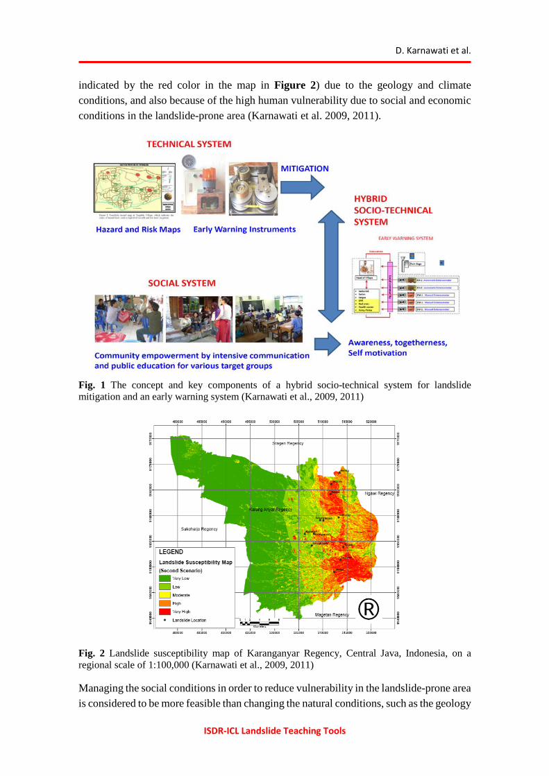
To ensure effectiveness in implementing any technologies for disaster risk reduction, a combined (hybrid) system, which takes into account both social and technical conditions has been developed by Karnawati et al. (2009, 2011). Such an approach mainly consists of the development of technical systems for providing community landslide hazard/risk maps and early warning systems, and also the social systems for developing an appropriate community empowerment program.
The technical system is recommended to address the development of methods utilizing the existing indigenous or local knowledge and technology, through considering the simplicity of such systems and technologies. Moreover, the utilization of local materials should be promoted, by encouraging local knowledge (by local experts and local operators) to drive the local participation program. Indeed, it is important that the hybrid system should involve low cost and simple technology, approaches and methods, so that it can be easily understood, reproduced, operated and maintained by the local community, such as suggested by Karnawati et al. (2008, 2009, 2011). This empowerment program relies on public education and encouraging community participation in developing and implementing action plans for disaster mitigation and risk reduction. A schematic concept of this approach is illustrated in Figure 1.
All of these approaches can be successful only if the local community has been empowered. Therefore, the process of technology development can be carried out during or as a part of the process of community empowerment.
4. Implementation of the Hybrid Socio-Technical System
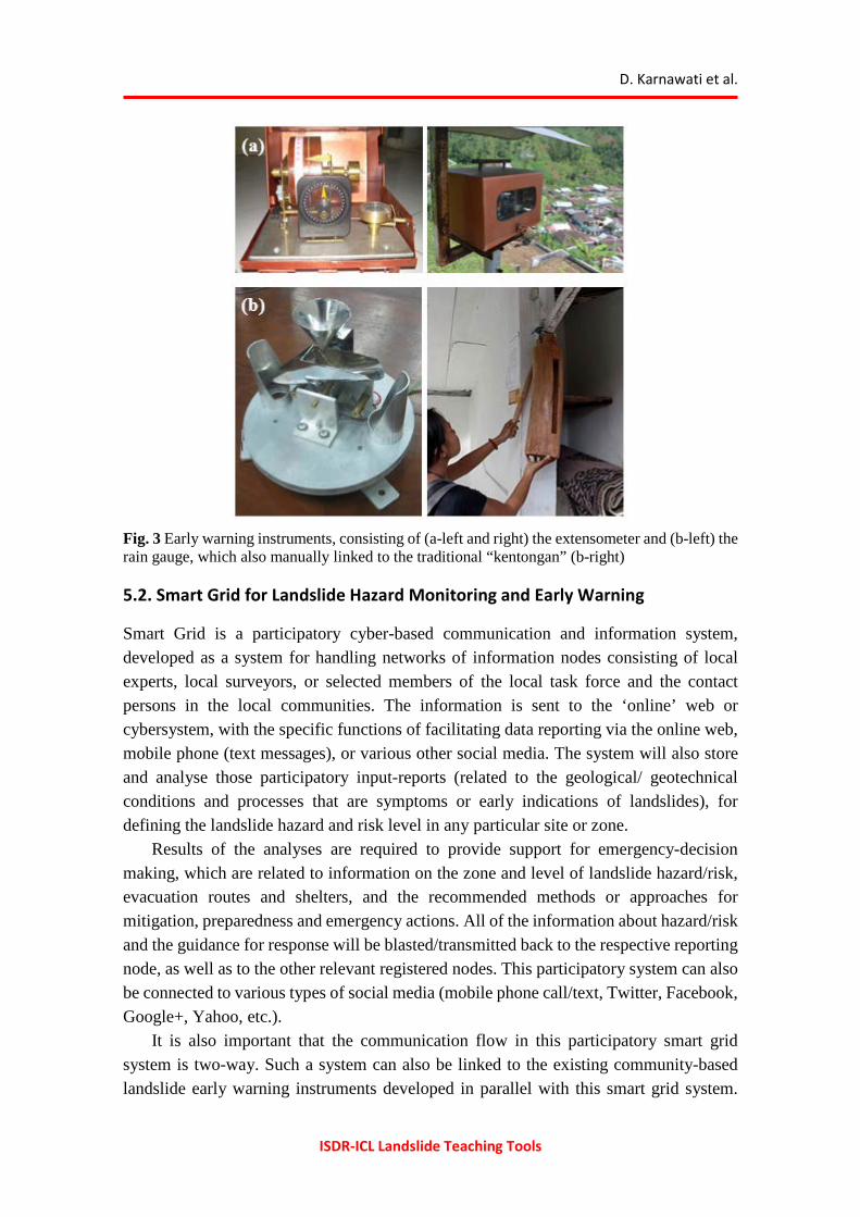
A hybrid socio-technical system has been implemented in one pilot area in Central Java, notably in Karanganyar Regency. This Regency is situated on the western slope of Lawu Volcano, in which 30% of the region is highly at risk from landslides (high susceptibility
D. Karnawati et al.
ISDR-ICL Landslide Teaching Tools
indicated by the red color in the map in Figure 2) due to the geology and climate conditions, and also because of the high human vulnerability due to social and economic conditions in the landslide-prone area (Karnawati et al. 2009, 2011).
Fig. 1 The concept and key components of a hybrid socio-technical system for landslide mitigation and an early warning system (Karnawati et al., 2009, 2011)
Fig. 2 Landslide susceptibility map of Karanganyar Regency, Central Java, Indonesia, on a regional scale of 1:100,000 (Karnawati et al., 2009, 2011)
Managing the social conditions in order to reduce vulnerability in the landslide-prone area is considered to be more feasible than changing the natural conditions, such as the geology

TXT-tool 4.062-1.1 A Socio-Technical Approach for Landslide Mitigation and Risk Reduction
ISDR-ICL Landslide Teaching Tools
and climate. Thus, the landslide disaster risk reduction in the pilot study area was conducted by targeting the social conditions through adaptive management, as suggested by Andayani et al. (2008), Karnawati et al. (2009, 2011), and also Halcombe et al. (2012). They emphasized improving community resilience by implementing a hybrid socio-technical approach.
5. Development of a Technical System
A technical system for landslide disaster risk reduction was developed by Karnawati et al. (2009, 2011, 2012). It consists of several technical components, such as the instruments for a landslide early warning system recommended by Fathani et al. (2008) and Fathani and Karnawati (2009), supported by a smart-grid for landslide hazard communication, monitoring and early warning developed by Karnawati et al. (2012), as well as the community-based landslide hazard map suggested by Karnawati et al. (2010).
5.1. Early Warning Instruments
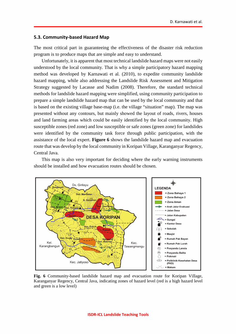
The early warning instruments were designed by relying on manual extensometers connected with an alarm powered by a dry battery, as illustrated in Figure 3a. Each of these instruments has a wire installed across the growing crack, so that the progress of crack development due to the slope movement can be monitored. The instalment of extensometers was also supplemented by a rain-gauge, as illustrated in Figure 3b, and a solar panel; so two different warning levels can be defined. The first threshold of warning was set up by setting the ON alarm in response to precipitation of 70 mm/hour or cumulative rainfall of 100 mm, whilst the second threshold was defined when the extension of the wire crossing the crack reached the distance of 5 cm. The first alarm was used for raising a community alert, and the second alarm was set up for starting evacuation in the landslide-prone zone.
It was also crucial that all of the alarm warning instruments were also manually backed-up by a traditional tool—a “kentongan” made of bamboo or wood (Fig. 3b right). This system, which combines the developed early warning instruments and the traditional or local warning system allowed a wider spread of the warning alarm sound. Admittedly, the numbers of early warning instruments are limited, and were not sufficient to cover the large area of the landslide-prone zone. Therefore, a smart grid for landslide early warning has been developed by Karnawati et al. (2012).
D. Karnawati et al.
ISDR-ICL Landslide Teaching Tools
Fig. 3 Early warning instruments, consisting of (a-left and right) the extensometer and (b-left) the rain gauge, which also manually linked to the traditional “kentongan” (b-right)
5.2. Smart Grid for Landslide Hazard Monitoring and Early Warning
Smart Grid is a participatory cyber-based communication and information system, developed as a system for handling networks of information nodes consisting of local experts, local surveyors, or selected members of the local task force and the contact persons in the local communities. The information is sent to the ‘online’ web or cybersystem, with the specific functions of facilitating data reporting via the online web, mobile phone (text messages), or various other social media. The system will also store and analyse those participatory input-reports (related to the geological/ geotechnical conditions and processes that are symptoms or early indications of landslides), for defining the landslide hazard and risk level in any particular site or zone.
Results of the analyses are required to provide support for emergency-decision making, which are related to information on the zone and level of landslide hazard/risk, evacuation routes and shelters, and the recommended methods or approaches for mitigation, preparedness and emergency actions. All of the information about hazard/risk and the guidance for response will be blasted/transmitted back to the respective reporting node, as well as to the other relevant registered nodes. This participatory system can also be connected to various types of social media (mobile phone call/text, Twitter, Facebook, Google+, Yahoo, etc.).
It is also important that the communication flow in this participatory smart grid system is two-way. Such a system can also be linked to the existing community-based landslide early warning instruments developed in parallel with this smart grid system.

TXT-tool 4.062-1.1 A Socio-Technical Approach for Landslide Mitigation and Risk Reduction
ISDR-ICL Landslide Teaching Tools
The concept of the smart grid design is illustrated in Figure 4, whilst an example of the web performance of a smart grid is displayed in Figure 5.
Fig. 4 Concept of an expert system in the smart grid design developed by Karnawati et al. (2012)
Fig. 5 Web page showing the geographical position of the reporting nodes
D. Karnawati et al.
ISDR-ICL Landslide Teaching Tools
5.3. Community-based Hazard Map
The most critical part in guaranteeing the effectiveness of the disaster risk reduction program is to produce maps that are simple and easy to understand.
Unfortunately, it is apparent that most technical landslide hazard maps were not easily understood by the local community. That is why a simple participatory hazard mapping method was developed by Karnawati et al. (2010), to expedite community landslide hazard mapping, while also addressing the Landslide Risk Assessment and Mitigation Strategy suggested by Lacasse and Nadim (2008). Therefore, the standard technical methods for landslide hazard mapping were simplified, using community participation to prepare a simple landslide hazard map that can be used by the local community and that is based on the existing village base-map (i.e. the village “situation” map). The map was presented without any contours, but mainly showed the layout of roads, rivers, houses and land farming areas which could be easily identified by the local community. High susceptible zones (red zone) and low susceptible or safe zones (green zone) for landslides were identified by the community task force through public participation, with the assistance of the local expert. Figure 6 shows the landslide hazard map and evacuation route that was develop by the local community in Koripan Village, Karanganyar Regency, Central Java.
This map is also very important for deciding where the early warning instruments should be installed and how evacuation routes should be chosen.
Fig. 6 Community-based landslide hazard map and evacuation route for Koripan Village, Karanganyar Regency, Central Java, indicating zones of hazard level (red is a high hazard level and green is a low level)

TXT-tool 4.062-1.1 A Socio-Technical Approach for Landslide Mitigation and Risk Reduction
ISDR-ICL Landslide Teaching Tools
6. Development of the Social System
Development of the social component in the hybrid system was initiated by social survey, to identify people’s existing knowledge about the landslide hazard, which will affect their perception of the landslide risk and their expectations for the proposed technology for landslide disaster risk reduction. Those aspects will significantly control their motivation or willingness to actively participate in any disaster risk reduction program. The results of this social survey will be crucial for formulating an appropriate and effective strategy for public education and for raising community awareness and for conducting a community empowerment program.
Various target groups were defined, consisting of the group of women (as the key person in the family), teachers, and children, as well as the younger and senior leaders. The local government of Karanganyar Regency also continuously and actively supported this social development program.
Results of the social survey indicated that most community members had been quite aware of the potential occurrence of landslides during the rainy season, because landslide disasters have quite frequently struck the area they lived in, especially during heavy or long continuous rainfall. Nevertheless, most of the community members preferred to remain living in their vulnerable region, instead of being relocated to the other areas that were safer. Obviously, the fertility of soil, the abundance of water resources, the beauty of the mountain scenery and the strong psychological engagement with their homeland or home-heritage strongly affected their willingness to leave their dangerous homeland. Unfortunately, they did not have enough knowledge, skill and capacity to decide about “what they should do” and “what they should not do” in case of landslides or to protect their life and environment from landslides. They were not yet capable of identifying the sites (slopes) that were susceptible to landsliding, or of recognizing the initial warning signs of possible landsliding. Therefore, the hybrid socio-technical approach for community-based landslide early warning was applied to develop their ability to carry out an appropriate landslide disaster risk reduction program. This will support the improvement of the community resiliency in this landslide-prone area.
A community task-force for disaster risk reduction at the village level was also established in coordination with the Agency for Disaster Management at the Regency level (Fig. 7). This network is also linked to the local hospital (health centre), the local army and police, and also the Search and Rescue Team (SAR team) at the local Regency. Indeed, this task force was the driving power for the disaster risk reduction program, and also effectively implementing and sustaining the technical systems for landslide risk reduction.

D. Karnawati et al.
ISDR-ICL Landslide Teaching Tools
7. Discussion
It was apparent that the existence of a community task force for landslide disaster risk reduction at each village level was the most important factor to ensure the effectiveness and sustainability of the landslide mitigation and risk reduction program. This task force had an important role as the driving agent in the empowerment and mitigation program. In fact, since this proposed hybrid socio-technical approach was implemented in several pilot areas in Karanganyar Regency, such as in Ledoksari Village in 2008, Tengklik Village in 2009, Matesih Village in 2010, Koripan Village in 2010 and also Gempolan and Plosorejo Villages in 2011, community resilience for landslide disasters has gradually increased. The socio-economical losses due to landslides have been minimised and the numbers of landslide victims have dropped to zero. It seems that this approach effectively empowered the local community to mitigate the landslides. The key people, who were also the members of the community task force and were in charge of the mitigation program, were also invited to share their experiences in community empowerment actions to tackle landslide problems in another landslide disaster area in Tanjungsani Village at Agam Regency, West Sumatera.
Therefore, the Hybrid Socio-Technical approach is also very applicable to other disaster-prone areas in developing countries, although several adjustments may be required to address the social and environmental characteristics of the specific community. Moreover, the importance of the commitment and leadership of the local Agency for Disaster Management at the Regency and District levels in supporting the effectiveness of the disaster management program at the village must be highlighted.
It was also obvious that the social, cultural and economical constraints can be minimized during the mitigation program by using the hybrid socio-technical approach. Indeed, the introduction and implementation of a new technology for early warning and disaster management system can be conducted more effectively through public participation. The enthusiastic response of the local community and local authorities to active participation in the landslide disaster risk reduction program is illustrated in Figure 7.

TXT-tool 4.062-1.1 A Socio-Technical Approach for Landslide Mitigation and Risk Reduction
ISDR-ICL Landslide Teaching Tools
Fig. 7 Activities to develop and empower the community task force at Tengklik Village, facilitated by the student community service program conducted by UniversitasGadjahMada
8. Conclusion
One of the most critical considerations for disaster risk reduction in Indonesia is the assurance of an effective and sustainable disaster management program. It is apparent that the proposed model, the combined (hybrid) socio-technical approach, has been quite effective in improving community resilience in villages vulnerable to landslides. It is also crucial that the system should be developed through community participation, with the provision of simple and low cost technology for landslide hazard mapping and early warning. Indeed, the establishment of a community task force at the village level is very important to ensure the effectiveness, continuity and sustainability of this proposed system. This approach may also be used to tackle similar problems of landslide risk reduction in other developing countries in Asia.
9. Acknowledgements
Special thanks are directed to the Indonesian Agency of National Disaster Management, the British Council DelPHE Program, as well as the Directorate General of Higher Education. We are grateful to the Indonesian Ministry of National Education and the Fulbright Senior Research Program funded by US Department of State’s Bureau of Education and Cultural Affairs for financial support to carry out the pilot studies. Acknowledgments are also extended to Universitas Gadjah Mada for the provision of

D. Karnawati et al.
ISDR-ICL Landslide Teaching Tools
academic facilities, as well as to the research assistant at the Laboratory of Environmental Geology and the Computing Laboratory of Civil and Environmental Engineering at Faculty of Engineering, Universitas Gadjah Mada. This research can be successfully conducted was due to the continuous and intensive assistance of Mr. Sani Tanaka Ismawanto, the student of Magister Instrumentation at the Faculty of Engineering, Universitas Gadjah Mada.
References
Annoname (2009) “Landslide disaster database” Indonesian National Agency for Disaster Mitigation.
Andayani B, Karnawati D and Pramumijoyo S (2008) Institutional framework for community empowerment towards landslide mitigation and risk reduction in Indonesia. Proc. of the 1st World Landslide Forum, Tokyo, Global Promotion Committee of the Int. Program on Landslide (IPL) – ISDR, pp. 57–59.
Anderson MG, Halcombe E, Esquivel M, Toro J, Ghesquire F (2010) The Efficacy of a Program of Landslide Risk Reduction in Area of Unplanned Housing in the Eastern of Caribbean. Environmental Management (45): 807–821.
Anderson MG, Halcombe E, Blake JR, Ghesquire F, Holm-Nielsen N, Fisseha T (2011) Reducing Landslide Risk in Communities; Evidence for the Eastern Caribbean. Applied Geography. Elsevier (31): 590–599.
Fathani TF, Karnawati D, Sassa K, Fukuoka H, Honda K (2008) Landslide Monitoring, Prediction and Early Warning in Banjarnegara, Indonesia. Proc. of 1st World Landslide Forum, Tokyo, pp. 195–198.
Fathani TF, Karnawati D (2009) Early warning of landslide for disaster risk reduction in Central Java Indonesia. Proc. of Int’l Workshop on Early Warning for Landslide Disaster Risk Reduction in the Eastern Asian Region: Kunming, China
Halcombe E, Smith S, Wright E, Anderson MG, (2012) Integrated Approach for Evaluating the Effectiveness of Landslide Risk Reduction in Unplanned Communities in the Caribbean. Nat. Hazards (61): 351–385.
Karnawati D, Fathani TF, Andayani B, Burton PW, Sudarno I (2009) Strategic program for landslide disaster risk reduction; a lesson learned from Central Java, Indonesia Disaster Management and Human Health Risk; Reducing Risk, Improving Outcomes, WIT Transactions on the Built Environment Transaction, K. Duncan and C.A. Brebbia, Ed. Southampton: WIT Press. 115–126.
Karnawati D, Setianto A, Wilopo W, Andayani B, Suharto (2010) Development of Community Landslide Hazard Map for Landslide Risk Reduction. Proceeding of 11th Int. Assoc. of Engineering Geologist Congress, Auckland, 5-10 September, 2010. Auckland, New Zealand. pp. 1203–1208.
Karnawati D, Fathani TF, Andayani B, Legono D, Burton PW (2011) Landslide hazard and Community-based Risk Reduction Effort in Karanganyar and the Surrounding Area Central Java, Indonesia. Journal of Mountain Science 8(2): 149–153.
Karnawati D, Frost EG, Fathani TF and Subroto (2012) Smart Grid for Landslide Monitoring and Early Warning System in Indonesia. Proceedings of the 10th Anniversary of ICL – January 2012, Kyoto, In Press
Lacasse S, Nadim F (2008) Landslide Risk Assessment and Mitigation Strategy. In Landslide Disaster Risk Reduction. (eds). Sassa K and Canuti P, Springer Verlag Berlin Heidenberg. p. 31–61.