twin peaks 2016 race book - dirty feet...
TRANSCRIPT
TWINPEAKS2016RaceBook
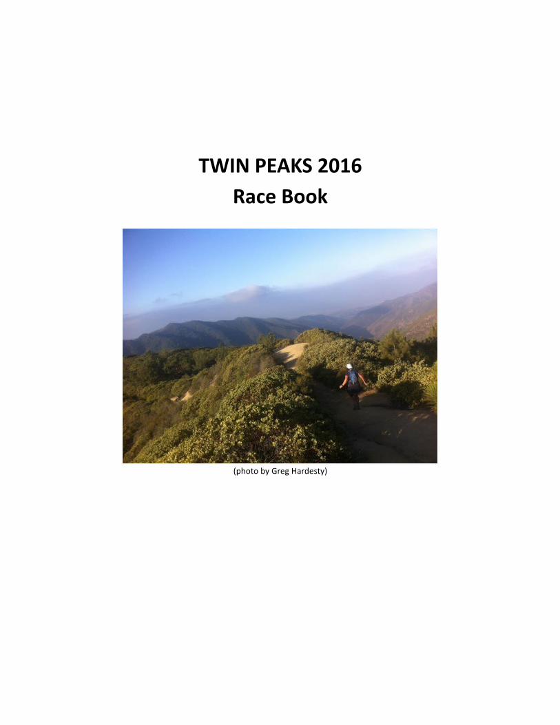
(photobyGregHardesty)
Table of Contents Introduction...........................................................................................................................................................3
Schedule of Events...............................................................................................................................................4
Race Check-in & Bib Pickup (3 options!)..................................................................................................4
Pre Race Dinner...........................................................................................................................................4
Host Hotel.....................................................................................................................................................4
2016 Sponsors.......................................................................................................................................................6
Race Rules..............................................................................................................................................................6
Aid Station Chart..................................................................................................................................................8
Aid Station Supplies & Food...............................................................................................................................8
First Aid..................................................................................................................................................................9
Drop Bags..............................................................................................................................................................9
Live Runner Tracking............................................................................................................................................9
Course Description and Maps............................................................................................................................9
Course Overview Map..............................................................................................................................10
50 KM..........................................................................................................................................................10
Elevation Profile for 50K...................................................................................................................11
50 Mile.........................................................................................................................................................11
Elevation Profile................................................................................................................................12
50 Mile Maps.....................................................................................................................................12
30K Course Map & Directions:..........................................................................................................................22
Awards..................................................................................................................................................................23
Course Flora & Fauna........................................................................................................................................23
Results..................................................................................................................................................................23

P a g e |3
Introduction
Welcome to the Twin Peak Ultra! The Santa Ana Mountains and Cleveland National Forest are home to hundreds of miles of scenic, breathtaking (sometimes literally!) and challenging trails. These trails are under the supervision of the Trabuco Ranger District of the Cleveland National Forest, and without their helpfulness and cooperation, we would not be able to use these trails for any type of recreational use. The idea for the Twin Peaks Ultra was born on a casual Santiago Peak training run in 2006, with an inaugural race in 2007. At the time there were no other races taking place in this perfect running playground. Without the cooperation of The Forest Service, and our many helpful volunteers, Twin Peaks (and other races like it), could not take place every year. I am always seeking to improve Twin Peaks, now it it’s 9th year, and make it a great and memorable experience each and every time you run it! No event is ever perfect, even though us RDs always try to make it so. At the conclusion of Twin Peaks (and every race I do), I always welcome helpful and constructive feedback. Thank you so much for your support and I look forward to seeing you at the starting line on October 15th. Jessica DeLine Race Director 619-770-7818 [email protected]

P a g e |4
Schedule of Events
Race Check-in & Bib Pickup (3 options!) Thursday, October 13th, 2016 @ 12PM-8PM
Location: 2XU Store – San Clemente
101 W Avenida Vista Hermosa #506, San Clemente, CA 92672
Friday, October 14th, 2016 @ 630PM-8PM
Location: Host Hotel
Holiday Inn Express & Suites, Corona CA
1550 Circle City Drive, Corona, CA
RACE DAY Saturday, October 15th, 2016 @ 4:30AM-7:45AM
Location: Indian Truck Trail (race start)
You may pick up your bib & shirt on Thursday, Friday, OR on race morning. Race day check-in begins at
4:30AM on Saturday, October 15th. If you are in the early start wave – please try to check in early if at all
possible.
Pre Race Dinner We’ll have some pizza at the packet pickup for free. If you don’t want pizza and are looking to carb load, a few
places close to the host hotel include:
Oggi’s Pizza 2363 California Ave #105 Corona, CA 92881
Romano’s Macaroni Grill 3591 Grand Oaks Corona, CA 92881
Porky’s Pizza 1240 E Ontario Ave Corona, CA 92881
Host Hotel Holiday Inn Express & Suites, Corona CA
1550 Circle City Drive, Corona, CA
Start Times:
50M = 6:00AM (early start by request for slower runners is at 5:00AM)
50K = 7:00AM, 30K = 8:00AM
Directions: Highway 15 South (from Corona) or North (from Lake Elsinore). West on Indian Truck Trail Road
(toward the mountains). First left at De Palma/Campbell Ranch Road. Turn right across from the Vons on
Santiago Canyon Road. Race is on the left about a half mile down Santiago Canyon Road @ Indian Truck Trail.
PLEASE RESPECT THE NEIGHBORS WITH WHERE YOU PARK AND HOW MUCH NOISE YOU MAKE IN THE
MORNING!!

P a g e |5
The starting location is located approximately (and with no traffic) 15 minutes south of
downtown Corona, 25 minutes from Riverside, 35 minutes from the Ontario Airport, 45
minutes from the Orange County Airport, 70 minutes from downtown LA (or the LA
Airport), and 85 minutes from San Diego.
Finish Time: Finish line closes @ 9:45PM. This gives you 15.5 hours to finish (17.7 minutes
per mile). Early starters will need to average 19.4 minutes per mile to finish on time (within
17 hours). Remember Twin Peaks finish times are closer to your average 100K finish and not your average 50
mile finish!
Parking: This is plenty of street parking near the race start/finish. You can park anyway along Santiago Canyon
Road. Please refrain from parking on the dirt road (Indian Truck Trail).
Weather: Normally October is a moderately dry and sometimes hot month. The average high for race day is
about 85 degrees with an average low of 54 degrees (records are around 100/40). Weather patterns can vary
considerably and it CAN rain (but VERY rarely snow) in October. These temps are for the start/finish area of
the race. It’s best to check the weather a day or two before the race and be prepared to dress in layers (and
bring sunscreen if it’s warm!). Remember the temperature can vary by 10-15 degrees from the canyons to the
peaks in this race (and it can get chilly near the top after dark). If weather is looking to be unusually hot, wet,
or cold, I will send out weather updates before the race.
Sunrise will be at 5:56AM and Sunset at 5:16PM. Early starters will probably want a headlamp. 6AM start can
get by without a headlamp.
October 16th is the full moon so there should be some light at night. It’s still HIGHLY recommended that you
wear a headlamp after dark.

P a g e |6
2016 Sponsors
Race Rules
1. Have fun!
2. Be Safe. There are many hazards along the course including (but not limited to), mountain lions, rough
terrain, rattle snakes, sharp cliffs and drop offs, etc. It is your responsibly to run safe and stay alert.
3. Except in case of medical emergency, runners may accept no aid nor assistance in any form from anyone,
including pacers and crews, between aid stations.
4. Each runner must carry all of his own food, fluids, clothing, and other supplies needed for use between aid
stations and must carry a minimum of 40oz of water.
5. Littering of any kind is strictly prohibited. Littering will result in the immediate disqualification of the runner
in this year's race, and for all future races.
6. Runners are responsible for the actions of their crews and pacers.

P a g e |7
7. Participants must follow the marked trail at all times. Any runner departing from the official trail must return
to the point of departure on foot before continuing.
8. Each runner must be checked IN at EVERY aid station. Runners not checked at each aid station may not be
credited with officially finishing the Run. If you do not leave an aid station – you MUST inform the crew.
9. Lights are HIGHLY RECOMMENDED for any runner reaching an aid station at 5:30PM or later.
10. Any entrant who is unable to finish the race must personally inform personal at the nearest aid station (or
support vehicle) of his or her decision to withdraw. You must turn in your bib at this time (you can get it later if
you want a souvenir). Runners who leave the course without turning in their bibs will be classified as "lost,"
and may be billed for charges incurred in any search and rescue operation.
11. Pacers are allowed in the 50 mile Race. Pacers should be experienced trail runners in excellent physical
shape and conditioned adequately to run approximately 18 miles over rough terrain. Pacers will pick up
runners at mile 34. Transportation will be provided to pacers from the starting line to the West Horsethief Aid
Station at approximately 12:00PM. We only have room for 3-4 pacers to go to mile 34. First come first serve.
Alternatively, with their own transportation, pacers may pick up their runner at any point from mile 30 onward.
Mile 30 (Holy Jim) is 4.5 miles from the paved road and mile 38 (Indian Truck Trail) is 6.5 mile up a dirt road.
12. Headphones are not recommended or encouraged. Use at your own risk.
13. Dogs are allowed on all trails. If you run with your dog, please do not run it more miles than it is
accustomed to. Run with your dog at your own risk (and risk of your dog).
14. All runners must be off the course by 9:45PM. We will adjust this accordingly based on start time of the
race.

P a g e |8
Aid Station Chart
50M 50K 30K Elevation Aid Open Close Cutoff
Start 0 0 0 1200' Full 4:30AM
IndianTT1 6.5 6.5 6.5 3800' Full 6:00AM
Horsethief1 10.5 10.5 4100' Full 7:00AM
HolyJim1 14.5 14.5 1700' Full 8:00AM
BearSprings1 19 19 8.5 4000' Water -
Santiago1 22 22 5687' Full 9:00AM
UpperHJBase1 25 25 7.5 4000' No - 1:45PM
BearSprings2 25.5 4000' Water -
HolyJim2 30 1700' Full - 3:00PM
Horsethief2 34 4100' Full - 4:15PM 4:30PM
IndianTT2 38 3800' Full -
UpperHJBase2 39 4000' No -
BearSprings3 39.5 4000' Water -
Santiago2 42 5687' Full - 7:00PM 7:00PM
UpperHJBase3 45 11.1 4000' No -
IndianTT3 46 26 12.1 3800' Full - 8:15PM 8:15PM
Finish 52.5 26.5 18.6 1200' Full 9:45PM 9:45PM
Aid station & Race Cutoff Times reflect a pace of about 17 minutes per mile for the regular start
and 19 minutes per mile for the early start (for the 50 Mile race). If you cannot make this pace, you will not make the cutoffs and may be pulled from the course.
NOTE: You MUST reach mile 25 by 1:45PM if you plan to run 50 miles.
If you reach mile 25 after 1:45PM, you must complete the 50k course instead.
Aid Station Supplies & Food
Aid stations will have Honey Stinger Gels and Wafers. Endurolytes will also be available on the course, as will
with water with Nuun. Indian Truck Trail, West Horsethief, Holy Jim, and Santiago Peak will have a mixture of
potatoes, PB&J, salty and sweet snacks, fruit, etc.

P a g e |9
First Aid
All aid stations have a first aid kit. EMTs will be stationed at West Horsethief (12-4PM), Indian Truck Trail (5-
8PM), and Start/Finish (12PM-10PM)
Drop Bags
Drop bags will be at SANTIAGO PEAK
Drop bags will be returned to the start/finish area in multiple waves. First round will come down around 12PM.
If you cannot stay to pick up your drop bag, you will need to make arrangements to pick it up at a later time in
Southern California (OC/San Diego area) or pay for shipping and packaging. IF you plan on the 50k drop
down option OR are running the 50K in general, inform the Santiago Peak aid station crew so they can set your
bag aside to be taken down earlier. Same goes for whenever you are DONE with your drop bag. Inform the
aid station so they can set it aside to take down.
Live Runner Tracking
This data can be found at: http://liveruncast.com/twinpeaks2016/runcast.php. We hope to update it every 15-
30 minutes (or at least every hour). Runner tracking is relayed via HAM radio from the aid stations to central
control under the operation of RACES (Riverside County Radio Amateur Civil Emergency Service). This data
will be added to a spreadsheet which will be accessed via a local wireless network then updated to the internet
at periodic intervals.
Course
Pacers are allowed starting at mile 30. (Holy Jim or West Horsthief aid station). We will be able to transport
some pacers so transportation will be on a first come first serve basis (please RSVP if your pacer needs a ride).
Otherwise, pacers will be responsible for their own transportation and it is recommended your pacer meets
you at the Holy Jim aid station (mile 30) if they do not catch a ride to West Horsethief. They may also meet you
at mile 38 (Indian Truck Trail), assuming they get up there on their own.
Course Description and Maps
The Twin Peaks course will be well marked and consists of 100% Singletrack and Fireroad in the beautiful Santa
Ana Mountains within the Cleveland National Forest (Start/Finish located in South Corona, CA). Intersections
will be marker with pink ribbon and/or flower. Signs will be on the course and pink ribbon will mark the trail.

P a g e |10
Course Overview Map
50 KM The 50K course is approximately 32.5 miles long with approximately 11,000’ of elevation gain. If you opt for
the 50K finish during the race, you must do so at mile 25. FYI – the 50K course is still HARD and not really a
wimp out but you will count toward the DNF rate for the 50 mile event if you registered for 50 miles.
Route directions (for 50KM)
Up Indian Truck Trail (6.5 miles)
Left on Main Divide @ aid station (for 4 miles)
Right on West Horsetheif @ aid station & stay right at bottom (becomes Trabuco Trail) for 4 miles.
Right on Holy Jim Trail @ aid station (for 4.5 miles)
Left on Main Divide @ unmanned aid station to Santiago Peak (3 miles)
Turn around and go back down (about 1.7 miles)
Left onto Upper Holy Jim Trail (just under 1 mile)
Left at bottom of Upper Holy Jim Trail @ radio checkpoint (for 1 mile)
Left at Indian Truck Trail @ aid station back to finish (6.5 miles)

P a g e |11
Elevation Profile for 50K
50 Mile
The 50 mile course is approximately 52.5 miles long with approximately 17,000’ of elevation gain.
Route Directions
Up Indian Truck Trail (6.5 miles)
Left on Main Divide @ aid station (for 4 miles)
Right on West Horsetheif @ aid station & stay right at bottom -becomes Trabuco Trail (for 4 miles)
Right on Holy Jim Trail @ aid station (for 4.5 miles)
Left on Main Divide @ unmanned aid station to Santiago Peak (3 miles)
turn around and go back down (about 1.7 miles)
Left onto Upper Holy Jim Trail (just under 1 mile)
Right at bottom of Upper Holy Jim @ radio checkpoint (for .5 miles)
Left at Holy Jim @ unmanned aid station (4.5 miles)
Left @ bottom of Holy Jim @ aid station (for 4 miles). (Stay left at split after about 2 miles to go UP West
Horsethief). Left at top of West Horsethief @ aid station (for 4 miles)
You will then stay on Main Divide for 4 more miles, passing Upper Holy Jim (radio only) & Bear Springs (water
only). After Santiago Peak aid station, turn around and go back down (about 1.7 miles)
Left onto Upper Holy Jim Trail (just under 1 mile)
Left at bottom of Upper Holy Jim Trail @ radio checkpoint (for 1 mile)
Left at Indian Truck Trail @ aid station back to finish (6.5 miles).
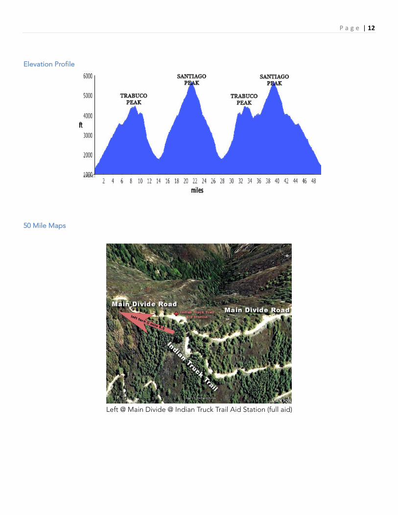
P a g e |12
Elevation Profile
50 Mile Maps
Left @ Main Divide @ Indian Truck Trail Aid Station (full aid)

P a g e |13
Turn right at West Horsethief Aid Station onto Singletrack West Horsethief Trail
Stay right at bottom of West Horsethief Trail

P a g e |14
Turn right onto Holy Jim Trail @ Holy Jim aid station
Stay on Holy Jim Trail – do not take side trail to Holy Jim Falls
Turn left on Main Divide @ Bear Springs Aid Station (water only - instaffed)

P a g e |15
At Santiago Peak Aid Station turn around and go back down the way you came up
Don’t miss the turn down Upper Holy Jim Singletrack near the large dirt/sand area

P a g e |16
Turn right on Main Divide @ radio checkpoint
50M runners can turn right here to “wimp out” and finish the 50K
Turn left on Holy Jim Trail @ the Bear Springs Aid Station

P a g e |17
Turn left on Trabuco Trail @ Holy Jim Aid Station
Turn left on West Horsethief Trail (don’t continue on Trabuco past this point!)

P a g e |18
Turn left on Main Divide at West Horsethief Aid Station
Continue straight through Indian Truck Trail Aid Station on Main Divide Road

P a g e |19
Go straight through checkpoint and stay on Main Divide Road
Go straight through Bear Springs Aid Station and stay on Main Divide Road

P a g e |20
At Santiago Peak Aid Station turn around and go back down the way you came up
Don’t miss the turn down Upper Holy Jim Singletrack near the large dirt/sand area

P a g e |21
Turn left on Main Divide @ checkpoint station
Turn left onto Indian Truck Trail @ Aid Station
6.5 miles downhill to the finish!
P a g e |22
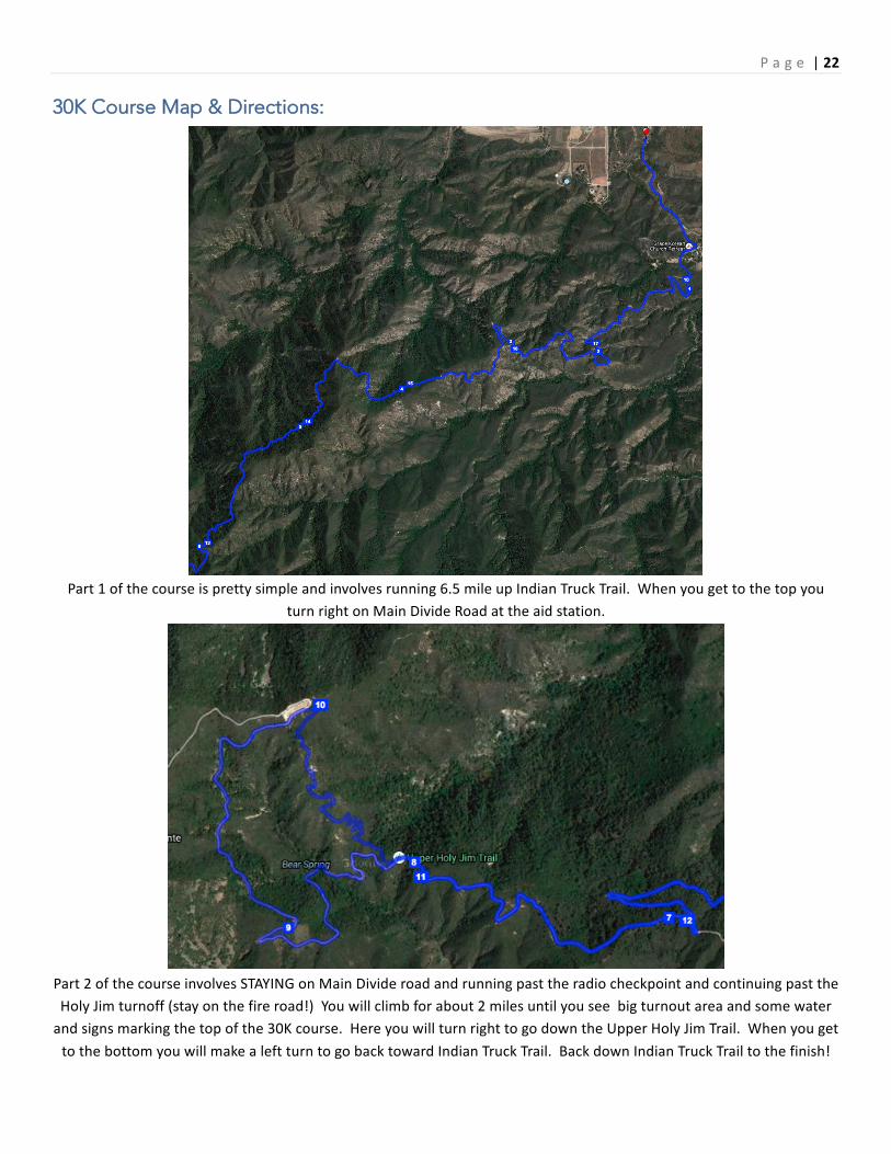
30K Course Map & Directions:
Part1ofthecourseisprettysimpleandinvolvesrunning6.5mileupIndianTruckTrail.Whenyougettothetopyou
turnrightonMainDivideRoadattheaidstation.
Part2ofthecourseinvolvesSTAYINGonMainDivideroadandrunningpasttheradiocheckpointandcontinuingpasttheHolyJimturnoff(stayonthefireroad!)Youwillclimbforabout2milesuntilyouseebigturnoutareaandsomewaterandsignsmarkingthetopofthe30Kcourse.HereyouwillturnrighttogodowntheUpperHolyJimTrail.WhenyougettothebottomyouwillmakealeftturntogobacktowardIndianTruckTrail.BackdownIndianTruckTrailtothefinish!

P a g e |23
Awards
All entrants will receive a long sleeve tech shirt. All finishers will receive a finisher’s medal. Top male and
female in each distance will receive cash prizes and age group winners will receive mugs.
Course Flora & Fauna
Notable plant life along the course includes the possibly of Poison Oak in the lower portions of the course in
Trabuco Canyon. This area includes the stretch from the bottom of West Horsethief Trail to the beginning of
the Holy Jim Trail. However, if Poison Oak is present (not common in October), it is usually very easily
avoidable if you stay on the well-maintained trails (you should never go off the trail anyway!)
Potential animals include deer, bobcats, mountain lions, coyotes, and rattlesnakes. There are no bear in the
Santa Ana Mountains. The animals listed are all normally very reclusive. Rattlesnakes can be active in October
if the temp is warm enough. If you have any concerns, please make yourself familiar with the various
precautions you can find on the Internet such as these: http://www.mountainlion.org/facts_safety.asp
http://www.dfg.ca.gov/news/issues/snake.html
This race is, of course, run at your own risk, so please be aware of your surroundings at all times (one reason
why headphones are not recommended). It is recommended that 50 mile runners run with a pacer or another
registered runner after dark (if possible).
Results
Preliminary results will be posted the day after the race before midnight (Oct 16th, 2016 by 11:59PM).
Preliminary results will be online during the race and immediately after at
http://liveruncast.com/twinpeaks2016/runcast.php