tsunamis around the world - atepatep ©2007 uaf geophysical institute b-1 tsunamis around the world...
TRANSCRIPT

ATEP ©2007 UAF Geophysical Institute B-1 Tsunamis Around the World
Grades5-8
TSUNAMI
Overview:Students learn about major tsunamis that have occurred in other parts of the world, and locate recent tsunamis on a world map using latitude and longitude.
Targeted Alaska Grade Level Expectations:Science[5 - 8] SA1.1 The student demonstrates an understanding of the processes of science by asking
questions, predicting, observing, describing, measuring, classifying, making general-izations, inferring, and communicating.
Objectives:The student will:• readareportofarecenttsunami;• uselatitudeandlongitudetolocatetsunamisonaworldmap;• describeatsunamieventtoclassmates;and• communicateandpresentinformationaboutonerecenttsunami.
Materials:• Poster-sizeworldmapswithlatitudeandlongitudelines(onepergroup)• Redstarstickers(small,onepergroup)• Redstickydots(small,fivepergroup)• Redpencils(oneperstudent)• STUDENTWORKSHEET:“TsunamisAroundtheWorld”
Science Basics:Large tsunamis leave behind clues that help scientists determine how extensive they were, and how large the earthquakes were that caused them. Tsunami research on two major tsunamis in Chile, one in 1575 and another in 1737, revealed that neither was likely to have been caused by a quake as large as the magnitude 9.5 quake that devastated the Chilean Coast in 1960. Using soil samples at elevationslikelytohavebeeninundatedbytsunamis,scientistsfindseasaltandotherocean-bornmatter. Scientists use the data to help unlock the mystery of past tsunamis. Today, instruments around the world record tsunamis as they occur, providing scientists with new data to help them understand these dangerous waves.
Activity Procedure:1. Explain that tsunamis have affected many coastal communities around the world. Some tsunamis do
relatively little harm, while others do a great deal of damage and result in many deaths.
2. Explainthatearthquakescausemosttsunamis;somearecausedbylandslidesorvolcaniceruptions.TheeruptionoftheKrakatauVolcanoin1883createdanexplosionheardmorethanhalf-wayaroundthe world, and caused a tsunami with waves up to 120 feet tall that killed 36,500 people and de-stroyed 295 towns.
3. Another unusual tsunami occurred on August 17, 1999, following a 7.6 magnitude earthquake in Tur-
Tsunamis Around the World

ATEP ©2007 UAF Geophysical Institute B-2 Tsunamis Around the World
key.Thetsunamiwasunusualbecauseitoccurredinasmall,inlandsea(theSeaofMarmara),notintheocean.Thetsunamiwavesclaimedthelivesof150people.Nearly17,000peoplewerekilledas a result of the earthquake in this highly populated area.
4. Explain that tsunamis occur nearly every year somewhere in the world, and that they are often de-structive and sometimes deadly. Explain that students will use the information they used in the previ-ous latitude and longitude lesson to map recent tsunamis around the world.
5. Explain that students will work in groups to learn about and map a recent tsunami event. Each group will present their map and describe their tsunami to the rest of the class.
6. Dividestudentsintogroupsoftwoormore.DistributeaSTUDENTINFORMATIONSHEET,aworldmap,aredstarstickerandfiveredstickydotstoeachgroup.
7. Explain that each information sheet describes a different tsunami. Ask students to read about their tsunami,thenplotthetsunamisourceontheirmapandmarkitwiththeredstar.Next,plotthefivepoints of greatest water height on the map and mark them with red dots.
8. Aftergroupshavecompletedtheirplotting,allowfiveminutesforgroupstoplanpresentations.Ex-plain that each group member must have a role in the presentation. Groups must share their maps and describe the tsunami that they studied.
9. DistributetheSTUDENTWORKSHEET:“TsunamisAroundtheWorld”andaskstudentstoindividu-ally plot the tsunami sources on the map.
Answers:
Critical Thinking:
Activity Response Method : Ask students to write a paragraph describing their re-sponsetothepresentationsofothergroups.Theycanbegintheirresponsewith“Iwassurprisedtolearn…”or“Ilearnedthat…”or“Iwonderif…”
180° 170° 160° 150° 140° 130° 120° 110° 100° 90° 80° 70° 60° 50° 40° 30° 20° 10° 0° 10° 20° 30° 40° 50° 60° 70° 80° 90° 100° 110° 120° 130° 140° 150° 160° 170° 180°
80°N
70°N
60°N
50°N
40°N
30°N
20°N
10°N
0°
10°S
20°S
30°S
40°S
50°S
60°S
70°S
80°S
West Longitude East LongitudeWorld Longitudes and Latitudes (cylindrical projection)
Peru, 2001•
Nicauragua, 1992•
Mexico, 1995•
Turkey, 1999•
•Papua New Guinea, 1998Java, 2006•
Sumatra•2004, 2005
•Japan1993, 2003
Vanuatu•1992, 2000

Name:____________________________________
ATEP ©2007 UAF Geophysical Institute B-3 Tsunamis Around the World
Grades5-8
TSUNAMI
Student Information Sheet“2001PeruTsunami”
On June 23, 2001, a magnitude 8.4 earthquake shook Peru. The quake generated a tsunami that wasobserved inmore than60 locationsas farawayasHawaii,JapanandAlaska.Theareaaround Camana, Peru sustained the most damage. The water height reached 8 meters in this region and more than 20 people died. Structures were severely damaged leaving thousands homeless. Many hotels and restaurants were destroyed.
Tsunami Source Information:
Date Place Name Earthquake Deaths Latitude Longitude
June 23, 2001 Peru magnitude 8.4 26 16º S 73º W
Top 5 Water Heights:
Location Water Height (meters)
Latitude Longitude
Camana, Peru 8.00 17º S 73º W
Arica, Chile 2.50 18º S 70º W
Talcahuano, Chile 2.50 36º S 73º W
Iquique, Chile 1.65 20º S 70º W
Coquimbo, Chile 1.30 30º S 71º W

Name:____________________________________
ATEP ©2007 UAF Geophysical Institute B-4 Tsunamis Around the World
Grades5-8
TSUNAMI
Student Information Sheet“2003JapanTsunami”
On September 25, 2003, a magnitude 8.3 earthquake shook Japan, generating a tsunami that was observed in 11 locations throughout the country. The area along the southeastern coast of Hokkaidowasstruckbythelargestwave,whichwas4metershigh.Fortunately,noliveswerelostduring the tsunami, though more than 700 were injured during the quake. The earthquake also caused $90 million in damages to structures.
Tsunami Source Information:
Date Place Name
Earthquake Deaths Latitude Longitude
September 25, 2003 Japan magnitude 8.3
0 42ºN 144º E
Top 5 Water Heights:
Location Water Height (meters)
Latitude Longitude
Cape Erimo, Japan 4.00 42ºN 143º E
Urakawa, Japan 1.30 42ºN 143º E
Kushiro,HokkaidoIs.,Japan 1.20 43ºN 144º E
Hachinohe,Honshu,Japan 1.00 41ºN 142º E
Nemuro,Japan 0.90 43ºN 146º E
Name:____________________________________
ATEP ©2007 UAF Geophysical Institute B-5 Tsunamis Around the World
Grades5-8
TSUNAMI
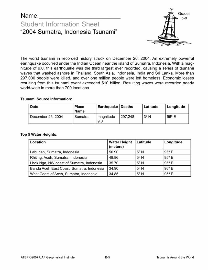
Student Information Sheet“2004Sumatra,IndonesiaTsunami”
Theworst tsunami in recorded history struck onDecember 26, 2004.An extremely powerfulearthquake occurred under the Indian Ocean near the island of Sumatra, Indonesia. With a mag-nitude of 9.0, this earthquake was the third largest ever recorded, causing a series of tsunami waves that washed ashore in Thailand, South Asia, Indonesia, India and Sri Lanka. More than 297,000 people were killed, and over one million people were left homeless. Economic losses resulting fromthis tsunamieventexceeded$10billion.Resultingwaveswererecordednearlyworld-wide in more than 700 locations.
Tsunami Source Information:
Date Place Name
Earthquake Deaths Latitude Longitude
December26,2004 Sumatra magnitude 9.0
297,248 3ºN 96º E
Top 5 Water Heights:
Location Water Height (meters)
Latitude Longitude
Labuhan, Sumatra, Indonesia 50.90 5ºN 95º E
Rhiting,Aceh,Sumatra,Indonesia 48.86 5ºN 95º E
LhokNga,NWcoastofSumatra,Indonesia 35.70 5ºN 95º E
Banda Aceh East Coast, Sumatra, Indonesia 34.90 5ºN 96º E
West Coast of Aceh, Sumatra, Indonesia 34.85 5ºN 95º E

Name:____________________________________
ATEP ©2007 UAF Geophysical Institute B-6 Tsunamis Around the World
Grades5-8
TSUNAMI
Student Information Sheet“2005Sumatra,IndonesiaTsunami”
On March 28, 2005, a magnitude 8.7 earthquake generated a tsu-nami which struck Indonesian coastlines. Ten lives were lost in the tsunami, but more than 1,300 perished as a result of the earthquake, which also caused extreme damage to structures. This dealt a discouraging blow to a region already devastated by the tsu-namiofthepreviousDecember.Wavesfromthe2005IndonesianTsunamiwererecordedin11locations;thegreatestwaveheightwas3meters.Minimaldamagewascausedbythetsunamiitself, though a port and airport were damaged.
Tsunami Source Information:
Date Place Name
Earthquake Deaths Latitude Longitude
March 28, 2005 Sumatra magnitude 8.7
1314 2ºN 97º E
Top 5 Water Heights:
Location Water Height (meters)
Latitude Longitude
Simeulue Island, Indonesia 3.00 3ºN 96º E
Singkil-Baru, Sumatra, Indonesia 1.00 2ºN 98º E
Salalah, Oman 0.39 17ºN 54º E
RodriguesIsland,PortMathurin,Mauritius 0.36 20º S 63º E
Colombo, Sri Lanka 0.31 7ºN 80º E

Name:____________________________________
ATEP ©2007 UAF Geophysical Institute B-7 Tsunamis Around the World
Grades5-8
TSUNAMI
Directions: Use the latitudes and longitudes, accurate to the nearest degree, from the tsunami databelowandthemaponthefollowingpagetofindandmarkrecenttsunamisourcesaroundthe world. Use a red pencil to mark where each earthquake occurred and write the name of the countryandtheyearnexttothemark.Writesmallenoughtofiteverythingonthemap.
Date Place Name Earthquake Deaths Latitude Longitude
1992, September 2 Nicaragua magnitude 7.7 168 12ºN 87º W
1993, July 12 Japan magnitude 7.7 239 42ºN 139º E
1995, October 9 Mexico magnitude 8.0 40 19ºN 104º W
1998, July 17 PapuaNewGuinea
magnitude 7.1 2,182 4º S 144º E
1999, August 17 Turkey magnitude 7.6 150 40ºN 30º E
1999,November26 Vanuatu magnitude 7.4 5 16º S 168º E
2001, June 23 Peru magnitude 8.4 100 16º S 73º W
2002, January 2 Vanuatu magnitude 6.3 0 17º S 167º E
2003, September 25 Japan magnitude 8.3 0 42ºN 144º E
2004,December26 Sumatra magnitude 9.0 297,248 3ºN 95º E
2005, March 28 Sumatra magnitude 8.7 2,909 2ºN 97º E
2006, July 17 Java magnitude 7.7 800 9º S 107º E
StudentWorksheet(page1of2)“TsunamisAroundtheWorld”

Name:____________________________________
ATEP ©2007 UAF Geophysical Institute B-8 Tsunamis Around the World
Grades5-8
TSUNAMI
StudentWorksheet(page2of2)“TsunamisAroundtheWorld”
180°170°
160°150°
140°130°
120°110°
100°90°
80°70°
60°50°
40°30°
20°10°
0°10°
20°30°
40°50°
60°70°
80°90°
100°110°
120°130°
140°150°
160°170°
180°80°N
70°N
60°N
50°N
40°N
30°N
20°N
10°N
0°
10°S
20°S
30°S
40°S
50°S
60°S
70°S
80°S
West Lo
ng
itud
eEast Lo
ng
itud
eW
orld
Lon
gitu
des an
d Latitu
des (cylin
drical p
rojectio
n)