tsunami summary · 2013-08-20 · tsunami washington state hiva / hazard mitigation plan 2006 /...
TRANSCRIPT
Tsunami
Washington State HIVA / Hazard Mitigation Plan 2006 / 2007 – Draft 1
Page 1
Summary
o The hazard – A tsunami is a train of waves typically generated by vertical displacement of the sea floor or lake bed caused by an earthquake. Tsunamis can cause significant death and destruction, with the greatest impact in areas closest to the source. The initial tsunami wave can arrive on shore within minutes of an earthquake, or up to several hours later, depending upon distance from the source.
o Previous occurrences – Tsunamis from locations across the Pacific Ocean basin
and from the Cascadia Subduction Zone off the Washington coast have hit coastal communities. Tsunamis generated by sources such as an earthquake on the Seattle Fault or the eruption of Mount St. Helens struck Puget Sound and other inland waters. Tsunamis hit Washington’s shorelines in the 900-930 era, 1700, the 1890’s, 1944-1953 era, 1949, 1960, 1964, and 1980.
o Probability of future events – Great earthquakes in the Pacific Ocean basin
generating tsunamis that could impact Washington’s outer coast and Strait of Juan de Fuca occur at a rate of about six every 100 years. In the Cascadia Subduction Zone, there is a 10 to 14 percent chance of a magnitude 9 earthquake and tsunami in the next 50 years. A rate of occurrence for local earthquakes and landslides that generate tsunamis has not determined.
o Jurisdictions at greatest risk – Communities along the Pacific Coast and Strait of
Juan de Fuca, including a number of coastal Indian tribes, are at greatest risk. In a Cascadia Subduction Zone earthquake, the level of the coast could fall six feet, and tsunami waves could reach 30 feet, overtopping several low-lying coastal communities. At-risk population is more than 43,000 on the outer coast, excluding tourists and transient populations that could increase the number significantly.
o Special note – In its earthquake and tsunami potential, the Cascadia Subduction
Zone resembles the Sunda Trench off the coast of Sumatra Island, Indonesia. The Sunda Trench produced giant earthquakes and tsunamis in December 2004 and March 2005 that killed more than 284,000 people and displaced another 1.1 million people in the Indian Ocean basin. Waves from the December 2004 tsunami reached 100 feet in places and traveled inland as far as five miles on Sumatra; the tsunami was so large it traveled around the world twice.
Introduction1, 2, 3
Tsunamis are trains of waves that threaten people and property along shorelines of the Pacific Coast, Strait of Juan de Fuca, Puget Sound, and large lakes. Sudden raising or lowering of the sea floor or a lake bed during an earthquake typically generates a tsunami, although landslides and underwater volcanic eruptions also can generate them.
Tsunami
Washington State HIVA / Hazard Mitigation Plan 2006 / 2007 – Draft 1
Page 2
Only as a tsunami approaches land does it become a hazard. In shallow water, it gains height as its waves slow and compress. Tsunamis come onshore resembling a series of quickly rising tides, and withdraw with currents much like those of a river. Swift currents commonly cause most of the damage from tsunamis. A Pacific Ocean tsunami can affect the entire Pacific basin, while a tsunami in inland waters can affect many miles of shoreline.
Tsunamis typically cause the most severe damage and casualties near their source. There, waves are highest because they have not yet lost much energy. The nearby coastal population often has little time to react before the tsunami arrives. Persons caught in the path of a tsunami often have little chance to survive; debris may crush them, or they may drown. Children and the elderly are particularly at risk, as they have less mobility, strength, and endurance.
Table 1. Recent Subduction Zone Earthquakes and Tsunamis Worldwide, 1960 - Present
Date Origin Effects Casualties
May 22, 19604 South-Central Chile EQ Magnitude 9.5
Largest earthquake in world. Damage to Chile, Hawaii (61 tsunami deaths), and Japan (118 tsunami deaths).
4,000-5,000 dead; 3,000 homeless; 2 million injured.
March 27, 19645 Prince William Sound, Alaska EQ Magnitude 9.2
Second-largest earthquake in 20th century. Shaking lasted 3 minutes. Severe damage to south coast of Alaska. Wave height at Valdez Inlet estimated at 220 feet. Tsunami deaths in AK, OR, Crescent City, CA.
125 dead (tsunami 110, EQ 15)
Aug. 23, 19766 Celebes Sea EQ Magnitude 7.9
Southwest Philippines struck, devastating Alicia, Pagadian, Cotabato and Davao.
8,000 dead
July 17, 19987 Papua New Guinea EQ Magnitude 7.1
Arop, Warapu, Sissano, and Malol Papua New Guinea devastated. Wave height estimated at 33 feet.
2,200 dead; 200 missing; 9,500 homeless
Dec. 26, 20048,9 Sumatra, Indonesia EQ Magnitude 9.0
Parts of Indonesia, Thailand, Malaysia, India, Sri Lanka, Maldives devastated. Wave heights reached 100 feet. Tsunami measured around the world.
283,000 dead; 14,100 missing; 1.1 million displaced
March 28, 200510 Sumatra, Indonesia EQ Magnitude 8.7
Parts of Sumatra Island, Indonesia badly damaged. Wave height estimated at 10 feet.
1,400 dead
A tsunami crosses the ocean at jetliner speeds, close to 600 miles per hour. The 1946 tsunami from Alaska’s Aleutian Islands took less than five hours to reach Hawaii, where it killed 159 people. The January 26, 1700 tsunami from the Cascadia Subduction Zone along the Pacific Coast of Washington took about 10 hours to reach Japan, where it caused flooding and damage along 600 miles of the Pacific coast of Honshu.
Tsunami
Washington State HIVA / Hazard Mitigation Plan 2006 / 2007 – Draft 1
Page 3
Tsunami waves in the ocean can continue for hours; later waves can be larger, more deadly, and more damaging. For example, the first wave to strike Crescent City, CA, following the 1964 Alaska earthquake was 9 feet above the tide level; the second was 6 feet above tide; the third was about 11 feet above the tide level; and the fourth, most damaging wave was more than 16 feet above the tide level. The third and fourth waves killed 11 people. Estimates of the damage range from $47 million to $97 million (2004 dollars). The same tsunami destroyed property in many areas along the Pacific coast from Alaska to California. In Washington, the largest wave entered Willapa Bay about 12 hours after the first one; the tsunami caused $640,000 (2004 dollars) in damage (see Table 2, page 5, for wave heights along the Washington coast).
Although the 1964 event was the largest 20th-century tsunami on the Washington coast, the state has its own sources of tsunamis, and these have produced great waves recorded geologically in the last few thousand years.
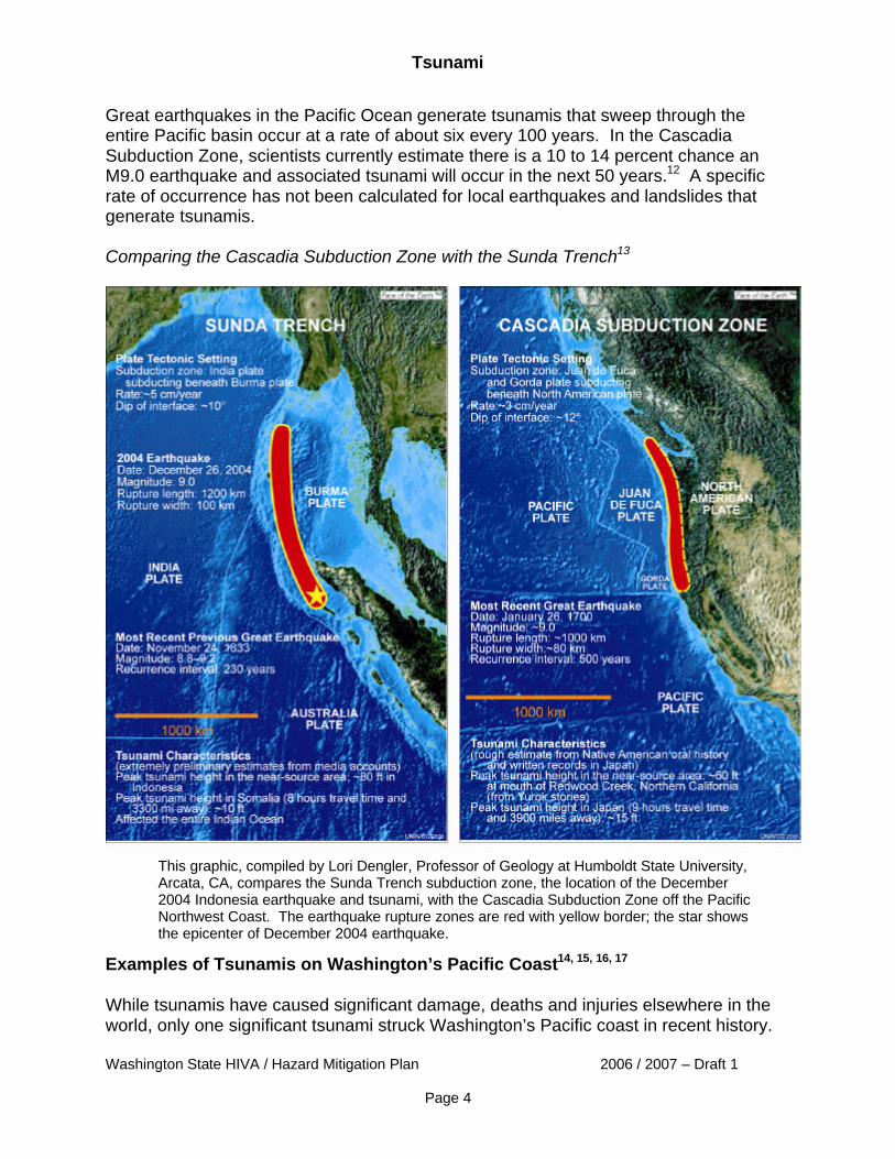
Tsunami Threat in Washington11 Washington’s outer coast is subject to tsunamis generated by distant sources such as earthquakes in Alaska and Chile, as well as from earthquakes in the Cascadia Subduction Zone along the coast. (For more information on the subduction zone, see the graphic on page 4, and the Earthquake hazard profile, __________.) The Cascadia Subduction Zone has generated magnitude 8 or larger earthquakes and tsunamis at least six times in the past 3,500 years. The most recent of these events occurred the evening of January 26, 1700. During such an earthquake, much of the land on Washington’s outer coast subsides, or falls, making coastal communities more susceptible to flooding and damage from a tsunami. Computer models indicate that a Cascadia-generated tsunami could reach nearly 30 feet in height and affect the entire Washington coast. The first wave would reach coastal communities within 30 minutes after the earthquake, and communities along the Strait of Juan de Fuca in 90 minutes. Tsunamis from great Cascadia earthquakes probably account for several sand sheets on northwestern Whidbey Island and at Discovery Bay in Puget Sound. The Cascadia Subduction Zone, in its earthquake and tsunami potential, is similar to the Sunda Trench off the coast of Sumatra Island, Indonesia. A graphic that compares those two geologic structures is on page 4. Washington’s inland waters also are subject to tsunamis. An earthquake in A.D. 900-930 on the Seattle Fault caused uplift that triggered a tsunami in central Puget Sound. And, a landslide into the Tacoma Narrows set off a tsunami a few days after the 1949 Olympia earthquake. Probability of Occurrence for Tsunami
Tsunami
Washington State HIVA / Hazard Mitigation Plan 2006 / 2007 – Draft 1
Page 4
Great earthquakes in the Pacific Ocean generate tsunamis that sweep through the entire Pacific basin occur at a rate of about six every 100 years. In the Cascadia Subduction Zone, scientists currently estimate there is a 10 to 14 percent chance an M9.0 earthquake and associated tsunami will occur in the next 50 years.12 A specific rate of occurrence has not been calculated for local earthquakes and landslides that generate tsunamis. Comparing the Cascadia Subduction Zone with the Sunda Trench13
Examples of Tsunamis on Washington’s Pacific Coast14, 15, 16, 17
While tsunamis have caused significant damage, deaths and injuries elsewhere in the world, only one significant tsunami struck Washington’s Pacific coast in recent history.
This graphic, compiled by Lori Dengler, Professor of Geology at Humboldt State University, Arcata, CA, compares the Sunda Trench subduction zone, the location of the December 2004 Indonesia earthquake and tsunami, with the Cascadia Subduction Zone off the Pacific Northwest Coast. The earthquake rupture zones are red with yellow border; the star shows the epicenter of December 2004 earthquake.
Tsunami
Washington State HIVA / Hazard Mitigation Plan 2006 / 2007 – Draft 1
Page 5
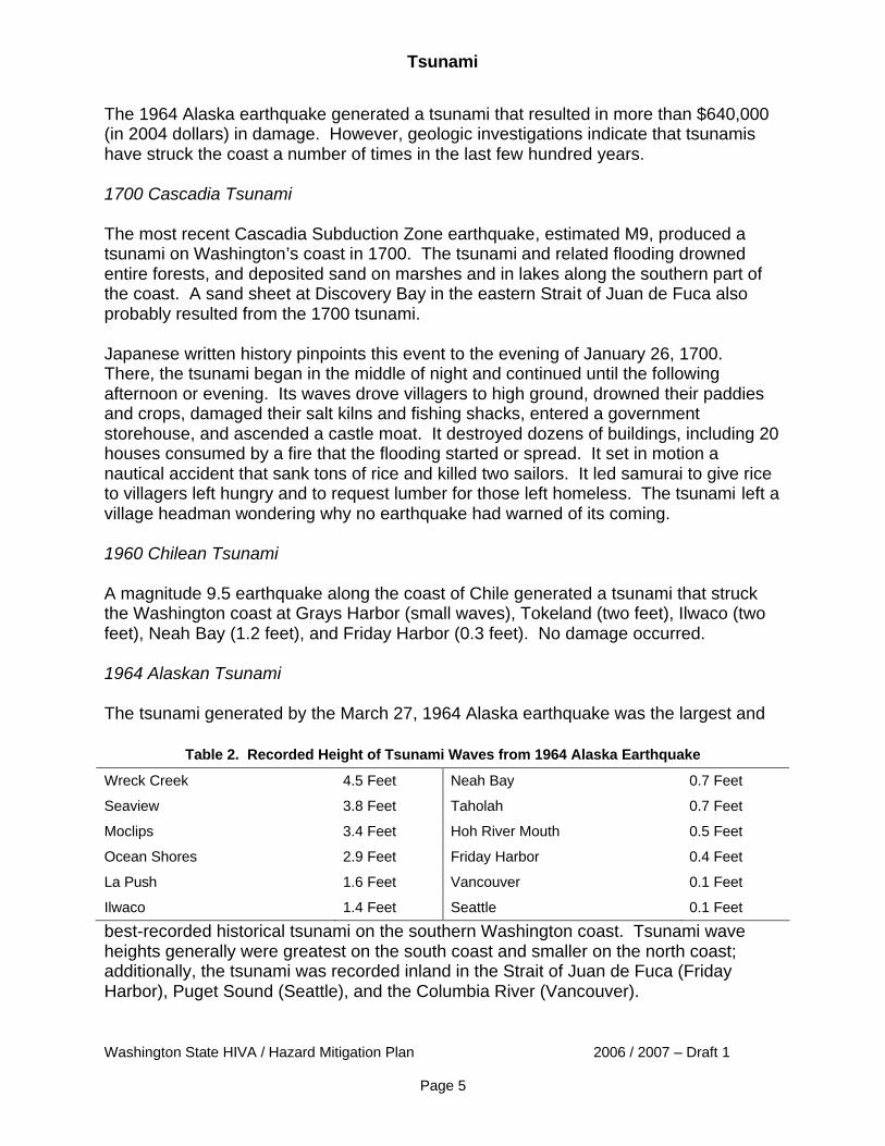
The 1964 Alaska earthquake generated a tsunami that resulted in more than $640,000 (in 2004 dollars) in damage. However, geologic investigations indicate that tsunamis have struck the coast a number of times in the last few hundred years. 1700 Cascadia Tsunami The most recent Cascadia Subduction Zone earthquake, estimated M9, produced a tsunami on Washington’s coast in 1700. The tsunami and related flooding drowned entire forests, and deposited sand on marshes and in lakes along the southern part of the coast. A sand sheet at Discovery Bay in the eastern Strait of Juan de Fuca also probably resulted from the 1700 tsunami. Japanese written history pinpoints this event to the evening of January 26, 1700. There, the tsunami began in the middle of night and continued until the following afternoon or evening. Its waves drove villagers to high ground, drowned their paddies and crops, damaged their salt kilns and fishing shacks, entered a government storehouse, and ascended a castle moat. It destroyed dozens of buildings, including 20 houses consumed by a fire that the flooding started or spread. It set in motion a nautical accident that sank tons of rice and killed two sailors. It led samurai to give rice to villagers left hungry and to request lumber for those left homeless. The tsunami left a village headman wondering why no earthquake had warned of its coming. 1960 Chilean Tsunami A magnitude 9.5 earthquake along the coast of Chile generated a tsunami that struck the Washington coast at Grays Harbor (small waves), Tokeland (two feet), Ilwaco (two feet), Neah Bay (1.2 feet), and Friday Harbor (0.3 feet). No damage occurred. 1964 Alaskan Tsunami The tsunami generated by the March 27, 1964 Alaska earthquake was the largest and
best-recorded historical tsunami on the southern Washington coast. Tsunami wave heights generally were greatest on the south coast and smaller on the north coast; additionally, the tsunami was recorded inland in the Strait of Juan de Fuca (Friday Harbor), Puget Sound (Seattle), and the Columbia River (Vancouver).
Table 2. Recorded Height of Tsunami Waves from 1964 Alaska Earthquake
Wreck Creek 4.5 Feet Neah Bay 0.7 Feet
Seaview 3.8 Feet Taholah 0.7 Feet
Moclips 3.4 Feet Hoh River Mouth 0.5 Feet
Ocean Shores 2.9 Feet Friday Harbor 0.4 Feet
La Push 1.6 Feet Vancouver 0.1 Feet
Ilwaco 1.4 Feet Seattle 0.1 Feet
Tsunami
Washington State HIVA / Hazard Mitigation Plan 2006 / 2007 – Draft 1
Page 6
Observations were made of the tsunami in Grays Harbor County at Westport, Joe Creek, Pacific Beach, Copalis, Grays Harbor City, and Boone Creek. Damages included debris deposits throughout the region, minor damage in Ilwaco, damage to two bridges on State Highway 109, a house and smaller buildings being lifted off foundations in Pacific Beach (the house was a total loss), and piling damaged at the Moore cannery near Ilwaco. Inland Tsunamis18, 19, 20, 21, 22
A.D. 900-930 Tsunami An earthquake sometime between 900 and 930 raised shores of central Puget Sound by 20 feet between the Duwamish River and Bremerton. The area of uplift included the floor of Puget Sound, which created a tsunami. In Seattle, the tsunami washed across West Point, where it deposited a sheet of sand. Farther north, it deposited a sand sheet at Cultus Bay on southern Whidbey Island and along tributaries of the Snohomish River between Everett and Marysville. Computer simulations of the tsunami show it reaching heights of 10 feet or more at the Seattle waterfront. Early 1800s Camano Head Tsunami Historical accounts among the Snohomish Indian people describe a landslide at Camano Head that sent a large wave south toward Hat Island. According to tribal accounts, the landslide sounded like thunder, buried a small village and created a large volume of dust. The tsunami washed over the barrier beach at Hat Island, destroying homes or encampments and drowning many people. The accounts make no mention of ground shaking, suggesting that the slide was not associated with a large earthquake. Camano Head is at the south end of Camano Island in Puget Sound. 1890s Puget Island Tsunami This tsunami occurred in the 1890s, but is not well documented. A landslide-triggered tsunami overran Puget Island in the Columbia River near Cathlamet. The wave killed one person. 1891 Puget Sound Tsunami Water in Lake Washington and Puget Sound surged onto beaches two feet above the high water mark, rocking vessels that had just pulled away from wharves, and causing an elevator in one building to bump against the side of the shaft. The likely cause of this November 29 event was two earthquake shocks and submarine landslides. 1894 Commencement Bay Tsunami
Tsunami
Washington State HIVA / Hazard Mitigation Plan 2006 / 2007 – Draft 1
Page 7
A submarine landslide in the delta of the Puyallup River in Commencement Bay, Tacoma, caused a tsunami. These events carried away a railroad track and roadway, resulting in two deaths. 1949 Puget Sound Tsunami A small landslide-generated tsunami struck the Point Defiance shoreline in the Tacoma Narrows on April 16, three days after a M7.1 earthquake weakened the hillside. According to local newspaper reports, an 11 million cubic yard landslide occurred when a 400-foot high cliff gave away and slid into Puget Sound. Water receded 20-25 feet from the normal tide line, and an eight-foot wave rushed back against the beach, smashing boats, docks, a wooden boardwalk, and other waterfront installations in the Salmon Beach area. The slide narrowly missed a row of waterfront homes struck by the tsunami. Lake Roosevelt Tsunamis Landslides into Lake Roosevelt in eastern Washington generated numerous tsunamis from 1944 to 1953 after Grand Coulee Dam created the lake on the Columbia River. Most tsunamis generated large waves (30 to 60 feet in height) that struck the opposite shore of the lake, with some waves observed miles from the source. Two tsunamis caused damage:
• February 23, 1951 – A 100,000 to 200,000 cubic yard landslide just north of Kettle Falls created a wave that picked up logs at the Harter Lumber Company Mill and flung them through the mill 10 feet above lake level.
• October 13, 1952 – A landslide 98 miles upstream of Grand Coulee Dam created
a wave that broke tugboats and barges loose from their moorings at the Lafferty Transportation Company six miles away. It also swept logs and other debris over a large area above lake level.
1980 Spirit Lake Tsunami The May 18, 1980 eruption of Mount St. Helens caused a massive tsunami in Spirit Lake. The sliding north face of the volcano slammed into the west arm of the lake, raising its surface an estimated 207 feet and sending a tsunami surging around the lake basin as high as 820 feet above the previous lake level. Displaced water rinsed the valley sides clean of timber and sediment, jamming logs and boulders against the landslide debris. In the east arm of Spirit Lake, the tsunami wave reached nearly 740 feet above old level of the lake, also washing trees off the sides of the valley and into the lake. Seiche23, 24
Tsunami
Washington State HIVA / Hazard Mitigation Plan 2006 / 2007 – Draft 1
Page 8
Seiches are water waves generated in enclosed or partly enclosed bodies of water such as reservoirs, lakes, bays and rivers by the passage of seismic waves (ground shaking) caused by earthquakes. Sedimentary basins beneath the body of water can amplify a seiche. Seismic waves also can amplify water waves by exciting the natural sloshing action in a body of water or focusing water waves onto a section of shoreline. In a 2003 paper, researchers at the University of Washington and the National Oceanic and Atmospheric Administration indicate that the geology of the sedimentary basin beneath Seattle amplifies seismic waves from large and distant earthquakes, contributing to the damaging effects of water waves in local enclosed bodies of water. The November 2002 magnitude 7.9 Denali earthquake in Alaska produced water waves damaging about 20 houseboats in Seattle’s Lake Union, buckling moorings, and breaking sewer and water lines. Sloshing action was reported in swimming pools, ponds and lakes around Seattle. Newspaper reports indicate water waves from the 1964 M9.2 Alaska earthquake caused similar damage on the lake; sloshing wave action also was reported following the 1949 M7.1 Olympia earthquake and the 1965 M6.5 Seattle earthquake in 1965. Researchers believe local amplification of seismic waves could make other urban areas above sedimentary basins in the region particularly vulnerable to seiches or water waves during large earthquakes on the Seattle Fault or the Cascadia Subduction Zone. Jurisdictions Most Vulnerable to Tsunami25, 26
Beaches open to the ocean, by bay entrances or tidal flats and the shores of coastal rivers, and some inland waters, are vulnerable to tsunamis. Washington began creating tsunami inundation models and maps for its Pacific Coast shoreline in the late 1990s using funds from the NOAA – Pacific Marine Environmental Laboratory’s National Tsunami Hazard Mitigation Program. To date, tsunami inundation mapping for a Cascadia Subduction Zone earthquake is complete for the shorelines of the Pacific Coast and Strait of Juan de Fuca. Modeling and mapping is complete for an earthquake on the Seattle Fault for Seattle. Modeling for tsunamis caused by surface faults in the Olympia, Tacoma, Bremerton, and Everett areas is underway or scheduled. The Washington Department of Natural Resources Division of Geology and Earth Resources prepares tsunami inundation maps from the modeling. Local governments then use inundation maps to develop evacuation maps for their communities. Pacific Coast, Strait of Juan de Fuca27, 28, 29 The National Tsunami Hazard Mitigation Program’s Center for Tsunami Inundation Mapping Efforts models use a M9.1 earthquake on the Cascadia Subduction Zone off the Washington coast as the generator of the tsunami.
Tsunami
Washington State HIVA / Hazard Mitigation Plan 2006 / 2007 – Draft 1
Page 9
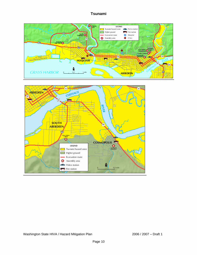
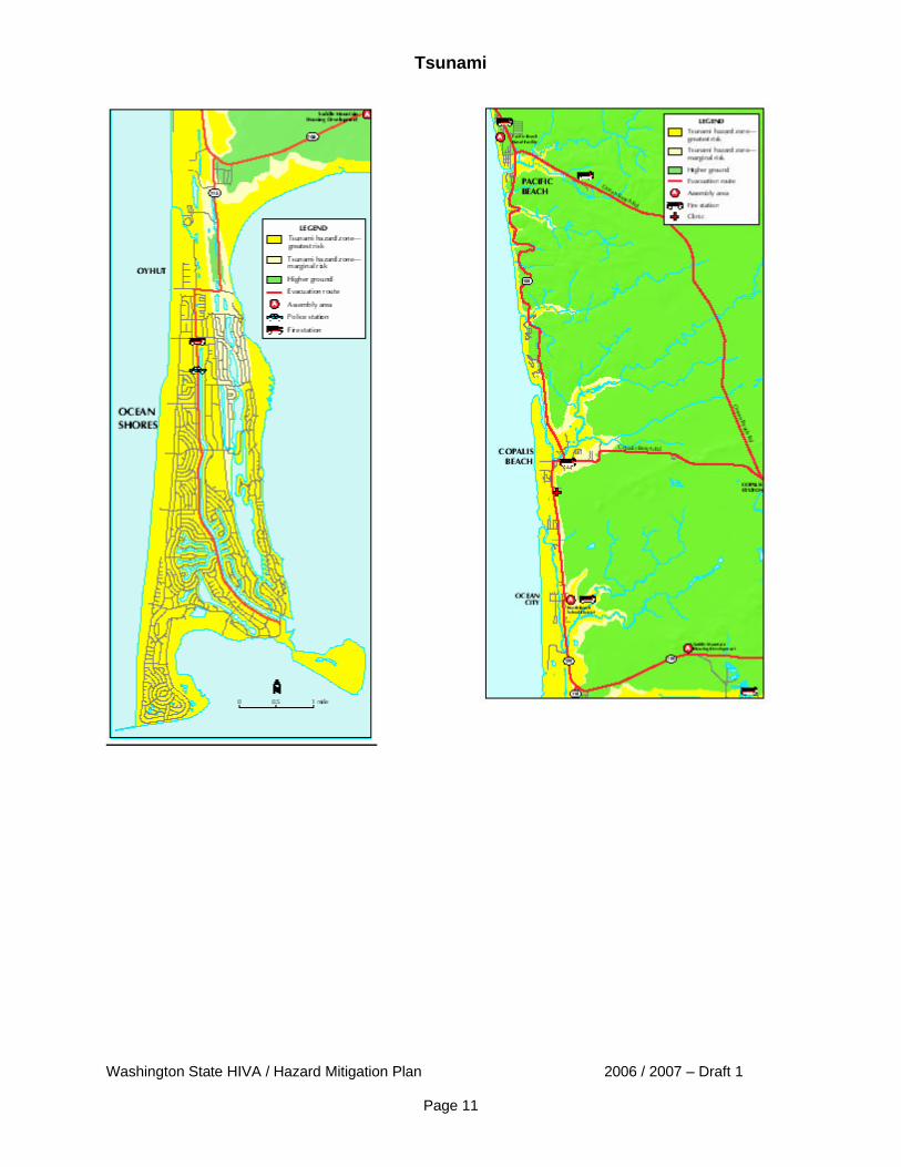
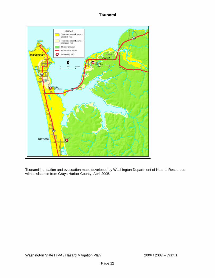
Projected at-risk coastal population of 43,740 is about one-quarter of the population of the four counties bordering the Pacific Coast.30 This number excludes thousands of tourists that populate at-risk beach areas at various times of the year. It does not include at-risk communities on the east end of the Strait of Juan de Fuca such as Bellingham, Anacortes and Mount Vernon, and Island and San Juan counties; their at-risk populations have not been calculated. A Cascadia tsunami will overtop several at-risk coastal communities including Bay Center, Long Beach, Ocean Park, Ocean Shores, Raymond, and Westport. Many of these communities are popular with tourists year-round. At-risk tribal communities include the Makah, Hoh, Quinault, Shoalwater, Quileute, and Lower Elwha Indian nations, each with small reservations in low-lying coastal areas. Most are impoverished with little to no infrastructure to support emergency planning and response. The first tsunami wave will arrive in at-risk communities on the outer coast 30 to 60 minutes after a great Cascadia earthquake, and about 90 minutes later in at-risk communities along the Strait of Juan de Fuca. Significant flooding is expected before the first wave because the earthquake will lower the elevation of the coast about five feet.37 Maximum flood depth and extent of flooding will depend on tide height at the time of tsunami arrival. Grays Harbor County – Projected at-risk population: 17,477 Communities with population at risk: Aberdeen, Cohassett Beach, Copalis Beach, Grayland, Hoquiam, Markham, Moclips, Ocean City, Ocean Shores, Oyehut-Hogans Corner, Taholah, Westport.
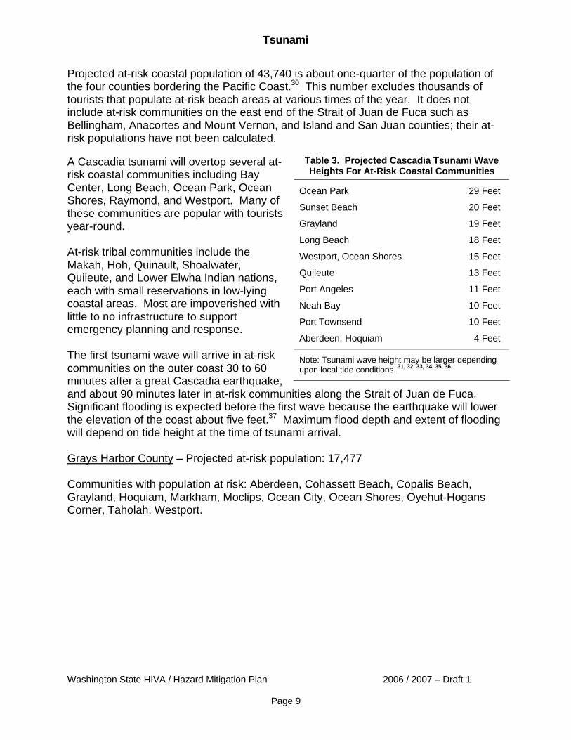
Table 3. Projected Cascadia Tsunami Wave Heights For At-Risk Coastal Communities
Ocean Park 29 Feet
Sunset Beach 20 Feet
Grayland 19 Feet
Long Beach 18 Feet
Westport, Ocean Shores 15 Feet
Quileute 13 Feet
Port Angeles 11 Feet
Neah Bay 10 Feet
Port Townsend 10 Feet
Aberdeen, Hoquiam 4 Feet
Note: Tsunami wave height may be larger depending upon local tide conditions. 31, 32, 33, 34, 35, 36
Tsunami
Washington State HIVA / Hazard Mitigation Plan 2006 / 2007 – Draft 1
Page 10
Tsunami
Washington State HIVA / Hazard Mitigation Plan 2006 / 2007 – Draft 1
Page 11
Tsunami
Washington State HIVA / Hazard Mitigation Plan 2006 / 2007 – Draft 1
Page 12
Tsunami inundation and evacuation maps developed by Washington Department of Natural Resources with assistance from Grays Harbor County, April 2005.
Tsunami
Washington State HIVA / Hazard Mitigation Plan 2006 / 2007 – Draft 1
Page 13
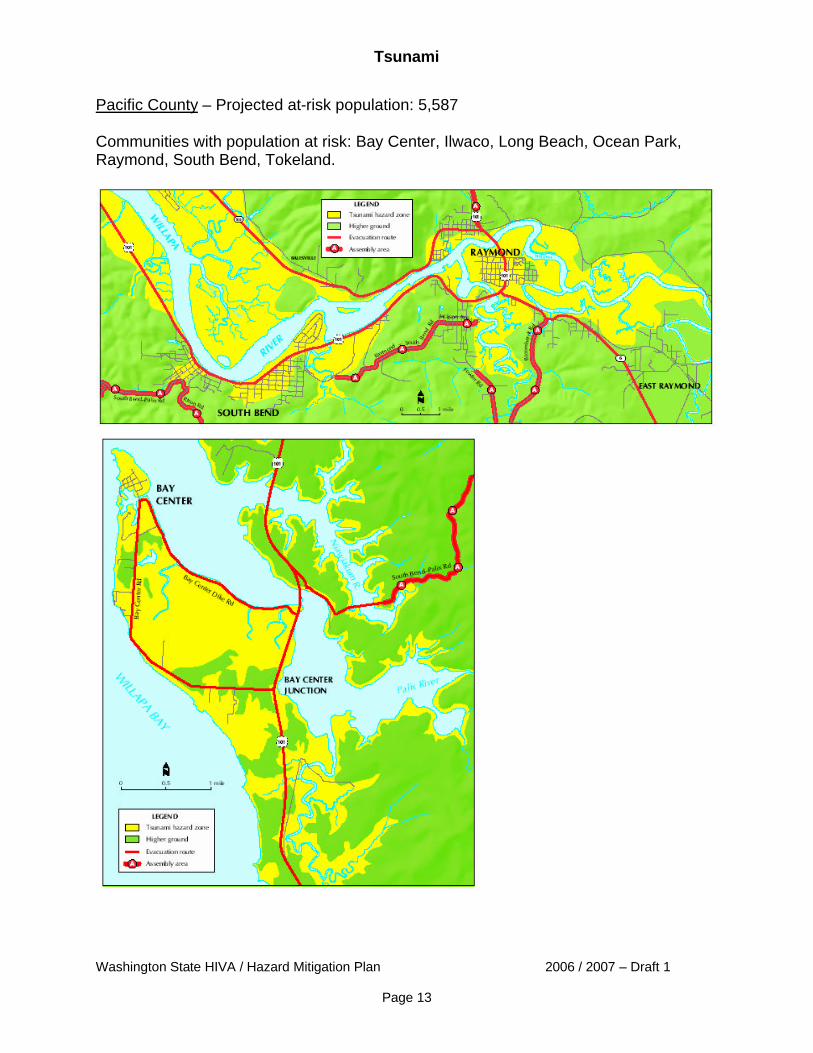
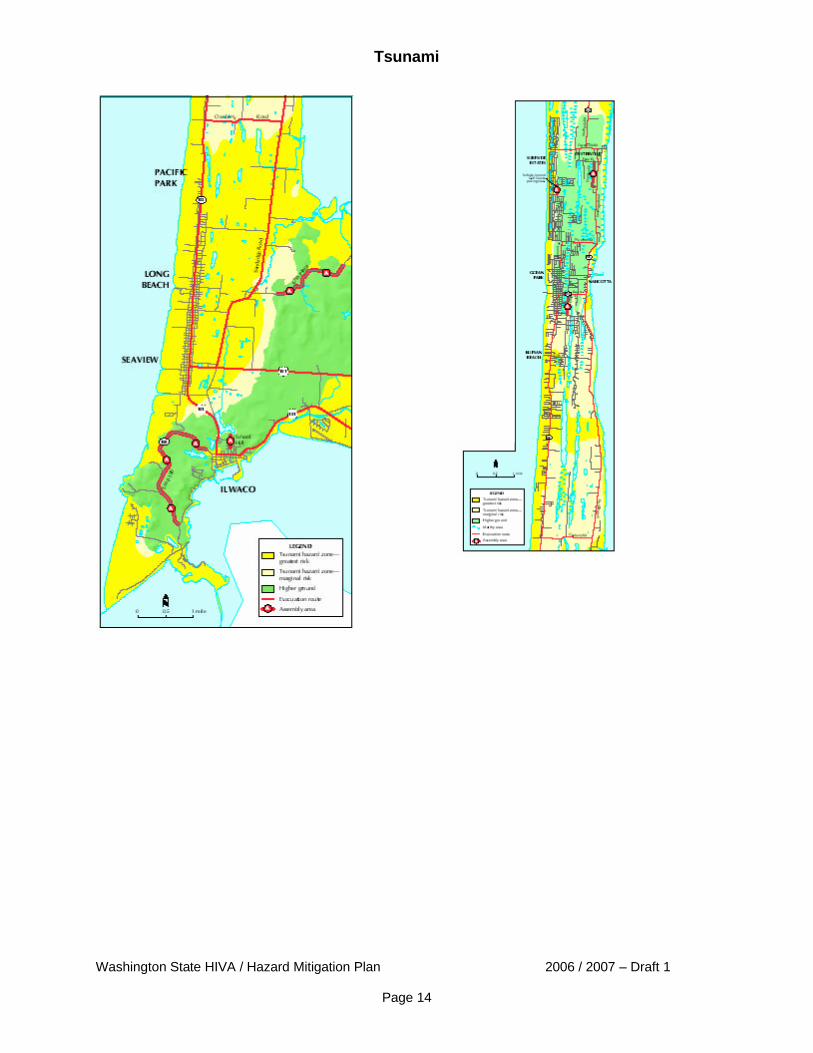
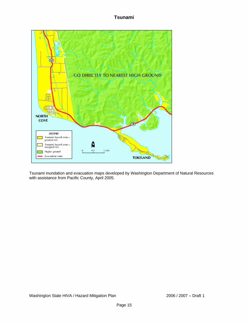
Pacific County – Projected at-risk population: 5,587 Communities with population at risk: Bay Center, Ilwaco, Long Beach, Ocean Park, Raymond, South Bend, Tokeland.
Tsunami
Washington State HIVA / Hazard Mitigation Plan 2006 / 2007 – Draft 1
Page 14
Tsunami
Washington State HIVA / Hazard Mitigation Plan 2006 / 2007 – Draft 1
Page 15
Tsunami inundation and evacuation maps developed by Washington Department of Natural Resources with assistance from Pacific County, April 2005.
Tsunami
Washington State HIVA / Hazard Mitigation Plan 2006 / 2007 – Draft 1
Page 16
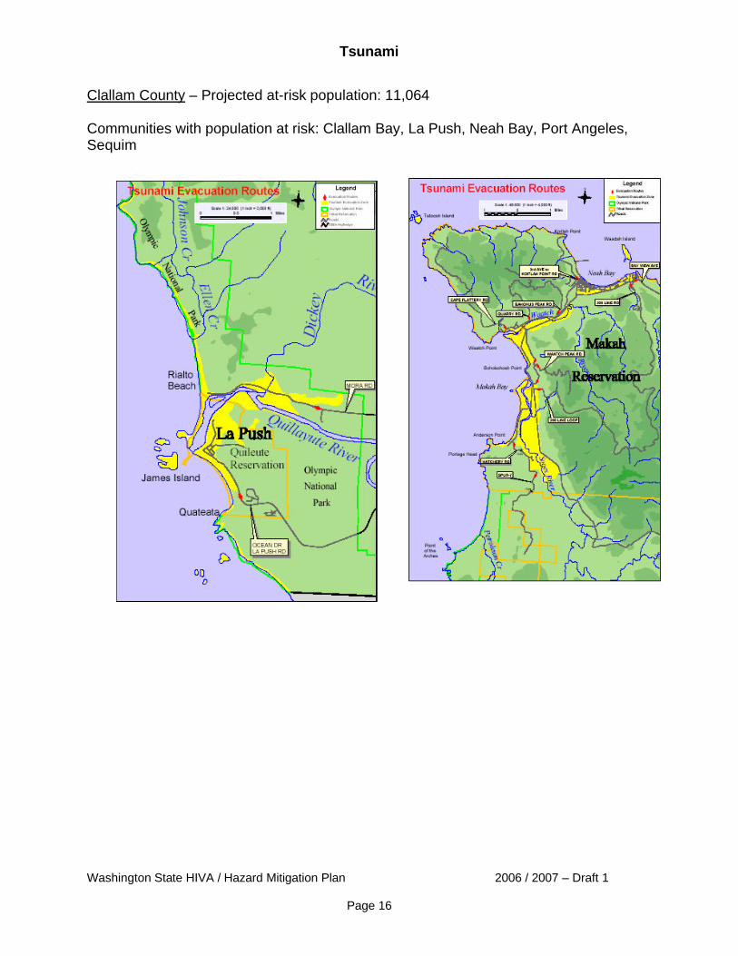
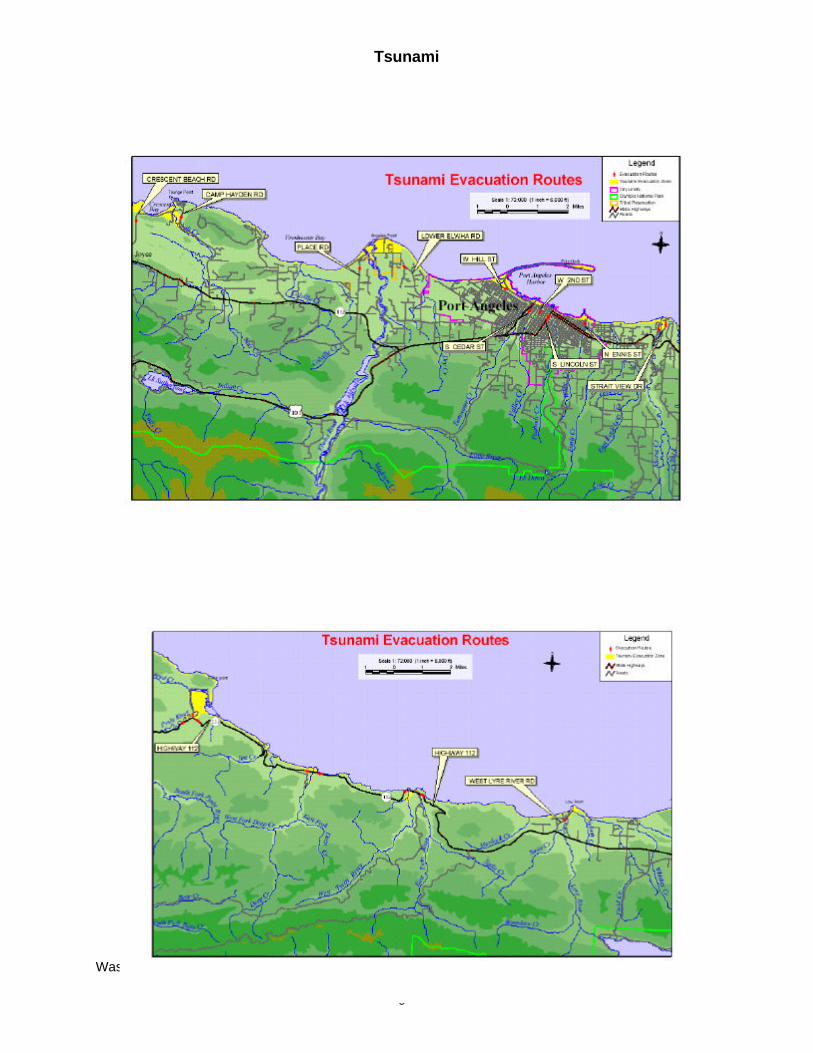
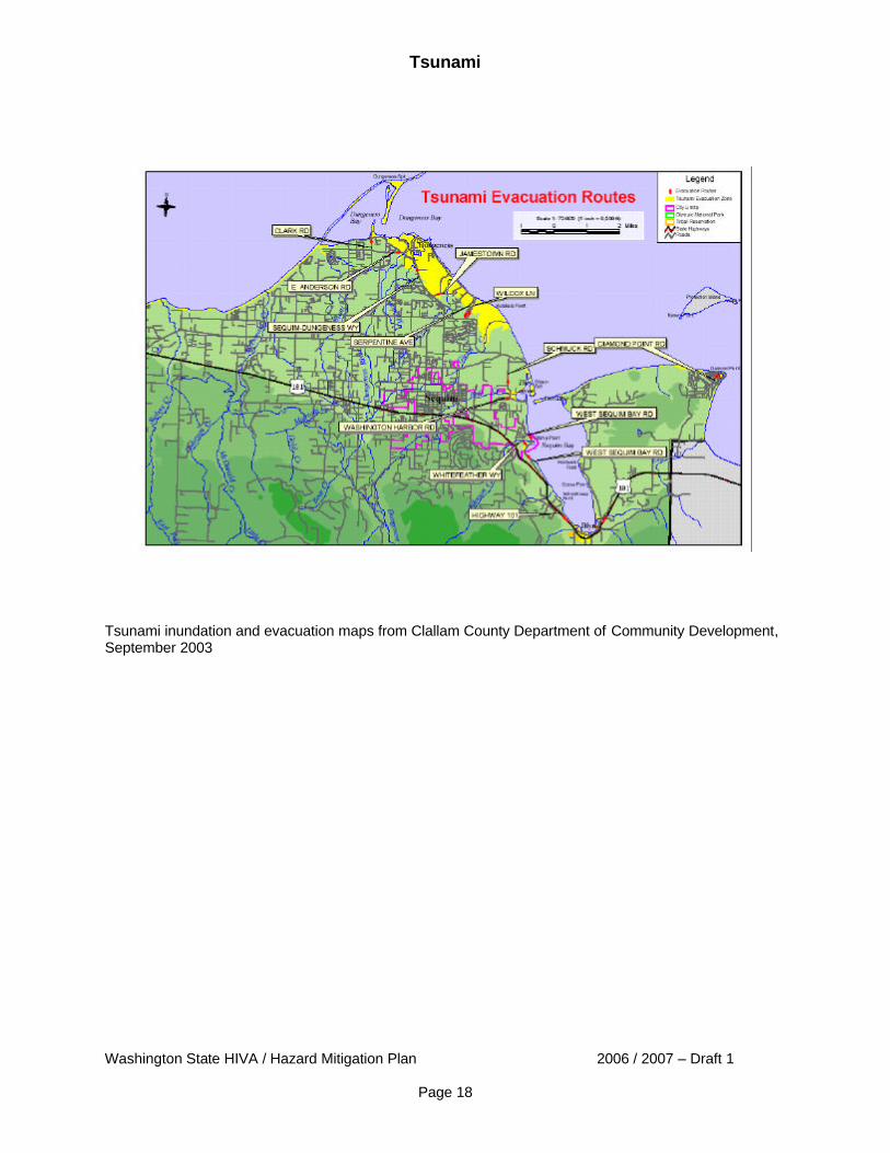
Clallam County – Projected at-risk population: 11,064 Communities with population at risk: Clallam Bay, La Push, Neah Bay, Port Angeles, Sequim
Tsunami
Washington State HIVA / Hazard Mitigation Plan 2006 / 2007 – Draft 1
Page 17
Tsunami
Washington State HIVA / Hazard Mitigation Plan 2006 / 2007 – Draft 1
Page 18
Tsunami inundation and evacuation maps from Clallam County Department of Community Development, September 2003
Tsunami
Washington State HIVA / Hazard Mitigation Plan 2006 / 2007 – Draft 1
Page 19
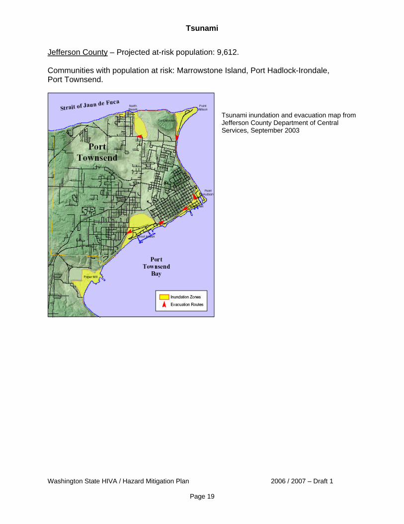
Jefferson County – Projected at-risk population: 9,612. Communities with population at risk: Marrowstone Island, Port Hadlock-Irondale, Port Townsend.
Tsunami inundation and evacuation map from Jefferson County Department of Central Services, September 2003
Tsunami
Washington State HIVA / Hazard Mitigation Plan 2006 / 2007 – Draft 1
Page 20
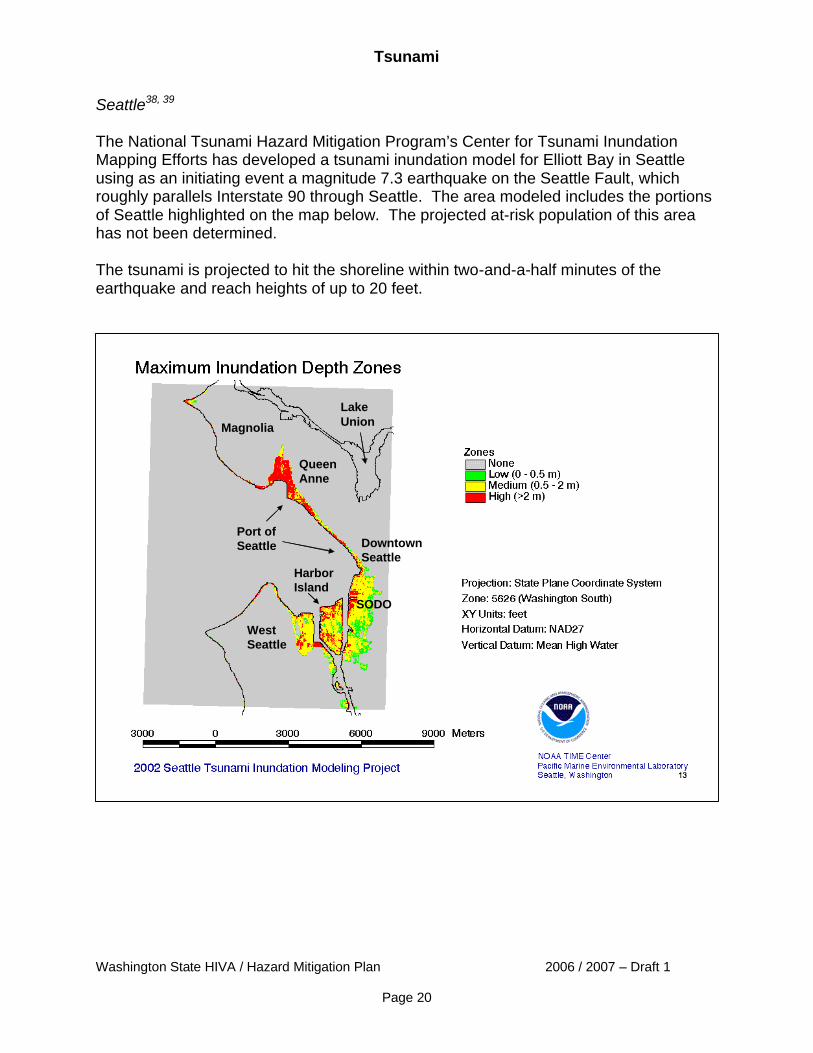
Seattle38, 39 The National Tsunami Hazard Mitigation Program’s Center for Tsunami Inundation Mapping Efforts has developed a tsunami inundation model for Elliott Bay in Seattle using as an initiating event a magnitude 7.3 earthquake on the Seattle Fault, which roughly parallels Interstate 90 through Seattle. The area modeled includes the portions of Seattle highlighted on the map below. The projected at-risk population of this area has not been determined. The tsunami is projected to hit the shoreline within two-and-a-half minutes of the earthquake and reach heights of up to 20 feet.
Downtown Seattle
Port of Seattle
Harbor Island
West Seattle
Magnolia
Queen Anne
Lake Union
SODO
Tsunami
Washington State HIVA / Hazard Mitigation Plan 2006 / 2007 – Draft 1
Page 21
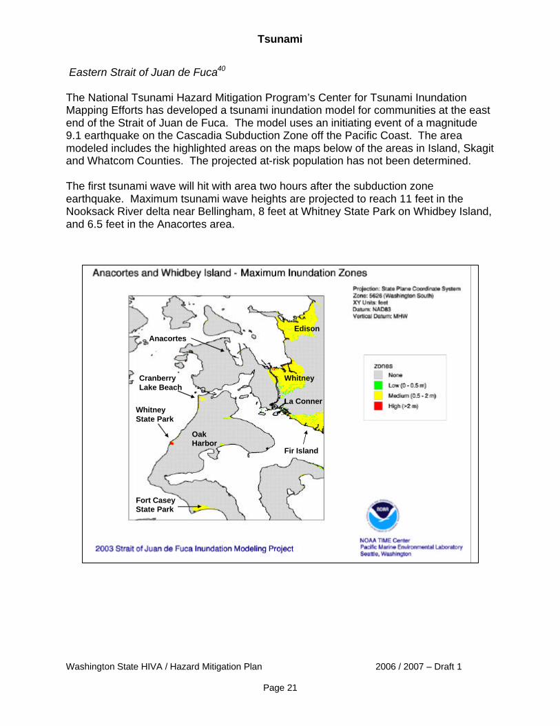
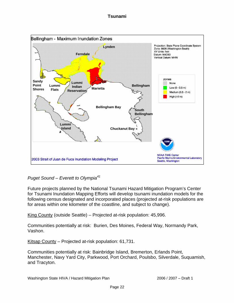
Eastern Strait of Juan de Fuca40 The National Tsunami Hazard Mitigation Program’s Center for Tsunami Inundation Mapping Efforts has developed a tsunami inundation model for communities at the east end of the Strait of Juan de Fuca. The model uses an initiating event of a magnitude 9.1 earthquake on the Cascadia Subduction Zone off the Pacific Coast. The area modeled includes the highlighted areas on the maps below of the areas in Island, Skagit and Whatcom Counties. The projected at-risk population has not been determined. The first tsunami wave will hit with area two hours after the subduction zone earthquake. Maximum tsunami wave heights are projected to reach 11 feet in the Nooksack River delta near Bellingham, 8 feet at Whitney State Park on Whidbey Island, and 6.5 feet in the Anacortes area.
Anacortes
La Conner
Fir Island
Whitney
Oak Harbor
Whitney State Park
Fort Casey State Park
Edison
Cranberry Lake Beach
Tsunami
Washington State HIVA / Hazard Mitigation Plan 2006 / 2007 – Draft 1
Page 22
Puget Sound – Everett to Olympia41 Future projects planned by the National Tsunami Hazard Mitigation Program’s Center for Tsunami Inundation Mapping Efforts will develop tsunami inundation models for the following census designated and incorporated places (projected at-risk populations are for areas within one kilometer of the coastline, and subject to change). King County (outside Seattle) – Projected at-risk population: 45,996. Communities potentially at risk: Burien, Des Moines, Federal Way, Normandy Park, Vashon. Kitsap County – Projected at-risk population: 61,731. Communities potentially at risk: Bainbridge Island, Bremerton, Erlands Point, Manchester, Navy Yard City, Parkwood, Port Orchard, Poulsbo, Silverdale, Suquamish, and Tracyton.
Lummi Indian
Reservation
Ferndale
Marietta
Sandy Point Shores
Lummi Flats
Bellingham
Chuckanut Bay
Bellingham Bay
Lummi Island
Lynden
South Bellingham
Tsunami
Washington State HIVA / Hazard Mitigation Plan 2006 / 2007 – Draft 1
Page 23
Mason County – Projected at-risk population: 1,994. Community potentially at risk: Allyn-Grapeview. Pierce County – Projected at-risk population: 55,900. Communities potentially at risk: Artondale, DuPont, Fox Island, Gig Harbor, Ruston, Steilacoom Tacoma, University Place. Snohomish County – Projected at-risk population: 55,661. Communities potentially at risk: Edmonds, Everett, Marysville, Mukilteo, Picnic Point-North Lynnwood, Shaker Church, Stanwood, Tulalip Bay, Warm Beach, Weallup Lake, Woodway. Thurston County – Projected at-risk population: 15,939. Communities potentially at risk: Lacey, Olympia, Priest Point, Tumwater. 1 Tsunamis, Washington Department of Natural Resources Division of Geology and Earth Resources, online fact sheet, <http://www.wa.gov/dnr/htdocs/ger/tsunami.htm>, (March 28, 2003). 2 NOAA and Tsunamis, National Tsunami Hazard Mitigation Project, National Oceanic and Atmospheric Administration, online fact sheet, <http://www.publicaffairs.noaa.gov/grounders/tsunamis.html>, (March 26, 2003). 3 Tsunamis: Frequently Asked Questions, National Tsunami Hazard Mitigation Project, National Oceanic and Atmospheric Administration, December 20, 2002, <http://www.pmel.noaa.gov/tsunami-hazard/tsunami_faqs.htm>, (May 2, 2003). 4 EQ Facts and Lists: Largest Earthquake in the World, U.S. Geological Survey Earthquake Hazards Program, <http://neic.usgs.gov/neis/eq_depot/world/1960_05_22.html> (September 22, 2005) 5 From Seismicity of the United States, 1568-1989 (Revised), Carl W. Stover and Jerry L. Coffman, U.S. Geological Survey Professional Paper 1527, U.S. Government Printing Office, Washington: 1993. 6 EQ Facts and Lists: Earthquakes with 1,000 or More Deaths from 1900, U.S. Geological Survey Earthquake Hazards Program, <http://neic.usgs.gov/neis/eqlists/eqsmajr.html>, (September 22, 2005) 7 Ibid. 8 Earthquake in the News: Magnitude 9.0 – Sumatra-Andaman Islands Earthquake, U.S. Geological Survey Earthquake Hazards Program, <http://earthquake.usgs.gov/eqinthenews/2004/usslav/>, (September 22, 2005). 9 The 26 December 2004 Indian Ocean Tsunami: Initial Findings from Sumatra, U.S. Geological Survey, <http://walrus.wr.usgs.gov/tsunami/sumatra05/index.html>, (September 21, 2005) 10 Earthquake in the News: Magnitude 8.7 – Northern Sumatra, Indonesia, U.S. Geological Survey Earthquake Hazards Program, <http://earthquake.usgs.gov/eqinthenews/2004/usweax/>, (September 22, 2005). 11 Frequently Asked Questions About Tsunamis, International Tsunami Information Center, National Oceanic and Atmospheric Administration, <http://www.prh.noaa.gov/pr/itic/Tsu_FAQs.htm>, (November 4, 2002).

Tsunami
Washington State HIVA / Hazard Mitigation Plan 2006 / 2007 – Draft 1
Page 24
12 Current approximate recurrence rate of M9.0 Cascadia Subduction Zone provided by Arthur D. Frankel, U.S. Geological Survey, in an oral presentation at the Workshop on Geologic Research in the Seattle Area, University of Washington, October 20, 2003. 13 Division of Geology and Earth Resources News, Washington Department of Natural Resources, Division of Geology and Earth Resources, Vol. 2, No. 1, Spring 2005. 14 Timothy J. Walsh et al., Tsunami Hazard Map of the Southern Washington Coast: Modeled Tsunami Inundation from a Cascadia Subduction Zone Earthquake, Washington Department of Natural Resources Division of Geology and Earth Resources, Geologic Map GM-49, October 2000. 15 Thomas J. Sokolowski, The Great Alaskan Earthquake and Tsunamis of 1964, West Coast and Alaska Tsunami Warning Center, <http://wcatwc.gov/64quake.htm>, (March 25, 2003). 16 April 13, 1949 Puget Sound Tsunami – Salmon Beach Narrative, West Coast and Alaska Tsunami Warning Center, National Oceanic and Atmospheric Administration, <http://wcatwc.noaa.gov/web_tsus/19490413/narrative1.htm>, (March 26, 2003). 17 Tsunamis Affecting the West Coast of the United States 1806 – 1992, National Geophysical Data Center Key to Geophysical Records Documentation No. 29, National Oceanic and Atmospheric Administration, December 1993. 18 High Shipman, The Fall of Camano Head: A Snohomish Account of a Large Landslide and Tsunami in Possession Sound During the Early 1800s, TsuInfo Alert, Volume 3, No. 6, December 2001. 19 Tsunamis Affecting the West Coast of the United States 1806 – 1992, National Geophysical Data Center Key to Geophysical Records Documentation No. 29, National Oceanic and Atmospheric Administration, December 1993. 20 Don J. Miller, Giant Waves in Lituya Bay Alaska – Shorter Contributions to General Geology, U.S. Department of the Interior, Geological Survey Professional Paper 354-C, 1960. 21 Lee Walkling, Infrequently Asked Questions, TsuInfo Alert, Volume 1, No. 2, February 1999. 22 Oral communication from Timothy J. Walsh, Chief Geologist, Washington Department of Natural Resources, May 1, 2003. 23 What Causes Damage, University of Washington, Pacific Northwest Seismograph Network fact sheet, <http://www.geophys.washington.edu/SEIS/PNSN/INFO_GENERAL/NQT/what_causes_damage.html>, (August 11, 2003). 24 A. Barberopoulou et al., Local Amplification of Seismic Waves from the M7.9 Alaska Earthquake and Damaging Seiches in Lake Union, Seattle, Washington, Paper No. 263-9, Geological Society of America, Vol. 35, No. 6, September 2003, p. 646. 25 National Tsunami Hazard Mitigation Program, National Oceanic and Atmospheric Administration Pacific Marine Environmental Laboratory, <http://www.pmel.noaa.gov/tsunami/time/wa/population/index.shtml>, (March 26, 2003). 26 V.V. Titov et al., 2003. NOAA TIME Seattle Tsunami Mapping Project: Procedures, data sources, and products, NOAA Technical Memo OAR PMEL-124 (in preparation). 27 General information and population figures from TIME Workshop – At-Risk Population, NOAA National Tsunami Hazard Mitigation Program Center for Tsunami Inundation Mapping Efforts, <http://www.pmel.noaa.gov/tsunami/time/wa/population/wa_1.shtml>, (March 26, 2003). 28 Timothy J. Walsh et al., Tsunami Hazard Map of the Port Angeles, Washington, Area, Washington Department of Natural Resources Division of Geology and Earth Resources, Open File Report 2002-1, August 2002. 29 Timothy J. Walsh et al., Tsunami Hazard Map of the Port Townsend, Washington, Area, Washington Department of Natural Resources Division of Geology and Earth Resources, Open File Report 2002-2, August 2002.
Tsunami
Washington State HIVA / Hazard Mitigation Plan 2006 / 2007 – Draft 1
Page 25
30 At-risk population figures from TIME Workshop – At-Risk Population, NOAA National Tsunami Hazard Mitigation Program Center for Tsunami Inundation Mapping Efforts, <http://www.pmel.noaa.gov/tsunami/time/wa/population/wa_1.shtml>, (March 26, 2003). 31 Tsunami Hazard Map of the Southern Washington Coast: Modeled Tsunami Inundation from a Cascadia Subduction Zone Earthquake, Timothy J. Walsh, et.al., Washington Department of Natural Resources, Geologic Map GM-49, October 2000. 32 Tsunami Inundation Map of the Neah Bay, Washington Area, Timothy J. Walsh, et.al., Washington Department of Natural Resources, OFR 2003-2, January 2003. 33 Tsunami Inundation Map of the Quileute, Washington Area, Timothy J. Walsh, et.al., Washington Department of Natural Resources, OFR 2003-1, January 2003. 34 Tsunami Inundation Map of the Port Townsend, Washington Area, Timothy J. Walsh, et.al., Washington Department of Natural Resources, OFR 2002-2, August 2002. 35 Tsunami Inundation Map of the Port Angeles, Washington Area, Timothy J. Walsh, et.al., Washington Department of Natural Resources, OFR 2002-1, August 2002. 36 A.J. Venturato, et.al., NOAA TIME Eastern Strait of Juan de Fuca, Washington, Mapping Project: Procedures, Date Sources, and Products, NOAA Technical Memorandum OAR PMEL-127, September 2004 37 Cascadia Subduction Zone tsunamis – Hazard Mapping at Yaquina Bay, Oregon, G.R. Priest, et.al., Oregon Department of Geology and Mineral Industries, Open File Report O-97-34, 1997. 38 TIME Workshop – At-Risk Population, NOAA National Tsunami Hazard Mitigation Program Center for Tsunami Inundation Mapping Efforts, <http://www.pmel.noaa.gov/tsunami/time/wa/population/wa_2.shtml>, (March 26, 2003). 39 V.V. Titov, et.al., NOAA TIME Seattle Mapping Project: Procedures, Date Sources, and Products, NOAA Technical Memorandum OAR PMEL-124, September 2003 40 Product Reports, 2003 Eastern Strait of Juan de Fuca Inundation Modeling Project, NOAA National Tsunami Hazard Mitigation Program Center for Tsunami Inundation Mapping Efforts, July 2003. 41 TIME Workshop – At-Risk Population, NOAA National Tsunami Hazard Mitigation Program Center for Tsunami Inundation Mapping Efforts, < http://www.pmel.noaa.gov/tsunami/time/wa/population/wa_3.shtml>, (March 26, 2003).