tsunami hazard mitigation by coral reef protection for the
TRANSCRIPT
Tsunami hazard mitigation by coral reef protection for
the French Caribbean Islands J. Roger, B. Dudon, B. Sédilot & N. Zahibo Laboratoire de Recherche en Géosciences et Energies, Département de Physique, Université des Antilles et de la Guyane, Guadeloupe, France E. Pelinovsky Department of Nonlinear Geophysical Processes, Institute of Applied Physics, Russian Academy of Sciences, Nizhny Novgorod, Russia SUMMARY: It is well known that the French Caribbean Islands have been impacted by a handful of tsunamis over the past centuries. Indeed, earthquakes reach magnitudes of Mw=7.0 and more; this active seismicity is related to the subduction occuring underneath the islands and is sometimes able to trigger local (2004) or regional tsunamis (1843, 1867). In addition, teletsunamis could travel across the North Atlantic Ocean from the Iberian Peninsula as the 1755 Lisbon tsunami. Tsunamis generated by several landslides and volcanic eruptions are also reported in catalogs. Modeling results obtained in previous studies and recent historical data searches have shown that some coastal places of the French Islands are highly inclined to tsunami waves amplification. With regards to other locations in the world, fringing coral reefs seem to play a preponderant role on tsunami coastal impact. This study aims to discuss this role in Guadeloupe Island using tsunami modeling. Keywords: tsunami, hazard, earthquake, reef, resonance 1. INTRODUCTION The Caribbean region is tectonically active, characterized by a moderate to high seismicity which allows to accommodate a 2 cm/yr average convergence between the North Atlantic and the Caribbean plates (DeMets et al., 2007) indicated on Fig. 1. The whole Caribbean Basin and more particularly the Lesser Antilles Islands have been impacted by a set of tsunamis in historical times (O'Loughlin and Lander, 2003). The accounts of wave arrival after an earthquake occurrence, a volcanic eruption or a landslide are more or less detailed and reliable and could always be discussed (Blanc, 2011). Nevertheless, some reports are sufficient to highlight the tsunami threat potential for the French Islands. Thus, it is well known that several tsunamis have been able to reach Guadeloupe, Martinique, Saint-Martin and Saint-Barthelemy Islands, as the 1755 Lisbon transoceanic tsunami (Roger et al., 2010a, 2010b; Zahibo et al., 2011) and the 1867 Virgin Islands tsunami (Zahibo et al., 2003). Local tsunamis could also have had severe consequences in these islands as the 1902 series associated with the Mount Pelée eruptive sequence in Martinique (Zahibo and Pelinovsky, 2001; Accary and Roger, 2010) or the 2004 Les Saintes tsunami (Zahibo et al., 2005). Thus, because of the frequent lack of testimonies in historical reports, it is interesting to determine the role played by the natural means of protection represented by coral reefs and mangroves on the historical and potential tsunami arrivals, since these ones were extremely more developed over the past until a couple of decades than today. In this way tsunami hazard assessment for the French Caribbean Islands is realized using these sparse destructive tsunamis as reference events. In addition, credible potential scenarios are proposed in agreement with the geology and tectonic of the considered region. For this study several scenarios have been tested over accurate bathymetric grids, among them the 1755 Lisbon and the 1867 Virgin Islands tsunamis. The February 8th, 1843 Northern Lesser Antilles megathrust earthquake with an estimated magnitude of 8.5 (Feuillet et al., 2011) is now tested as the worst case scenario for Guadeloupe Island in terms of shaking intensities, in order to determine its tsunami generation capability and the potential of coastal impact, especially along the Guadeloupian
Archipelago coasts.
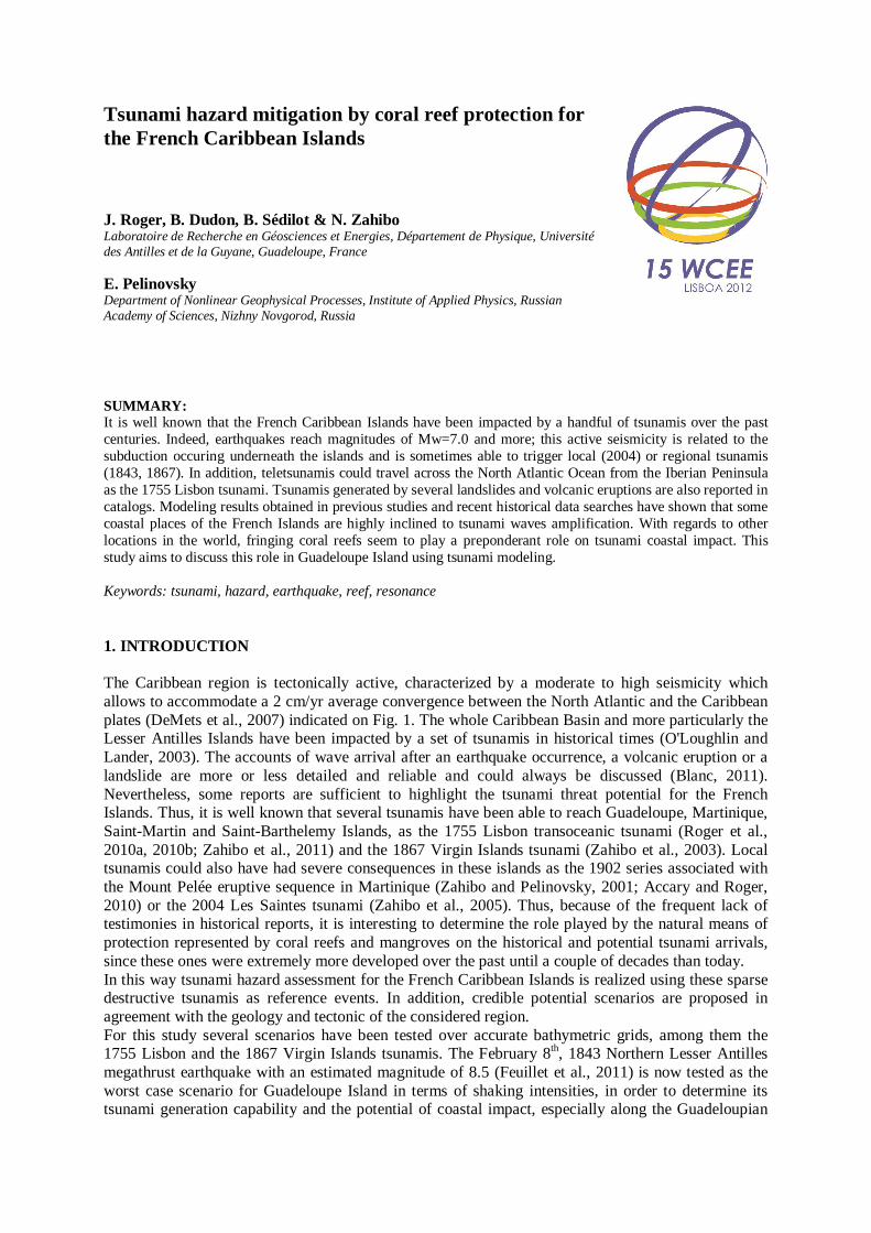
Figure 1. (a) Location of the French Islands within the Lesser Antilles Arc; Ma.: Martinique, Gu.: Guadeloupe; St-M.: Saint-Martin; St-B.: Saint-Barthelemy; an approximate convergence rate of ~2cm/yr from DeMets et al. (2007) is indicated as well as the subduction trench between the North-American and Caribbean tectonic plates; inset locates the Lesser Antilles Arc in the Caribbean region with a red rectangle. (b, c, d, e) Repartition of the
fringing coral reefs (red lines) surrounding the French Caribbean Islands. Saint-François and Sainte-Anne (Guadeloupe) are located with yellow and blue stars on (c).
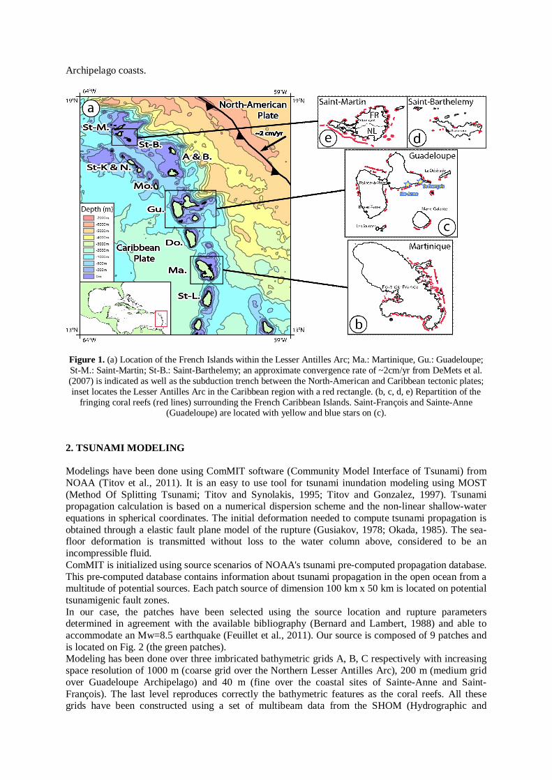
2. TSUNAMI MODELING Modelings have been done using ComMIT software (Community Model Interface of Tsunami) from NOAA (Titov et al., 2011). It is an easy to use tool for tsunami inundation modeling using MOST (Method Of Splitting Tsunami; Titov and Synolakis, 1995; Titov and Gonzalez, 1997). Tsunami propagation calculation is based on a numerical dispersion scheme and the non-linear shallow-water equations in spherical coordinates. The initial deformation needed to compute tsunami propagation is obtained through a elastic fault plane model of the rupture (Gusiakov, 1978; Okada, 1985). The sea-floor deformation is transmitted without loss to the water column above, considered to be an incompressible fluid. ComMIT is initialized using source scenarios of NOAA's tsunami pre-computed propagation database. This pre-computed database contains information about tsunami propagation in the open ocean from a multitude of potential sources. Each patch source of dimension 100 km x 50 km is located on potential tsunamigenic fault zones. In our case, the patches have been selected using the source location and rupture parameters determined in agreement with the available bibliography (Bernard and Lambert, 1988) and able to accommodate an Mw=8.5 earthquake (Feuillet et al., 2011). Our source is composed of 9 patches and is located on Fig. 2 (the green patches). Modeling has been done over three imbricated bathymetric grids A, B, C respectively with increasing space resolution of 1000 m (coarse grid over the Northern Lesser Antilles Arc), 200 m (medium grid over Guadeloupe Archipelago) and 40 m (fine over the coastal sites of Sainte-Anne and Saint-François). The last level reproduces correctly the bathymetric features as the coral reefs. All these grids have been constructed using a set of multibeam data from the SHOM (Hydrographic and
Oceanographic Service of the French Navy) combined with ETOPO 1 Global Relief Model dataset (http://ngdc.noaa.gov/mgg/global/global.html), georeferenced and digitized nautical chart of Guadeloupe Archipelago (SHOM, 1994) and SRTM 3" (http://www2.jpl.nasa.gov/srtm/) for inundation calculation (resolution ≈ 90 m). Their geographical extents are indicated on Fig. 2.
Figure 2. Area of the 1843 rupture zone as proposed by Feuillet et al. (2011) within the Northern Lesser Antilles (pink dashed line). The green rectangles indicate the geographical extents of modeling grids A, B and C. The star
represents a possible epicenter location of the February 8th, 1843 earthquake. 3. RESULTS AND DISCUSSION First modeling results show that a 1843-like Mw=8.5 coseismic rupture could trigger a catastrophic tsunami towards the Lesser Antilles populated coasts and particularly in Guadeloupe which is located very close to the estimated rupture zone (Fig. 2). The tsunami maximum wave heights map obtained for Guadeloupe Archipelago (Fig. 3 top), reaching about 5 m, shows that several coastal points are more prone to wave amplification. For information, there is an actual lack of historical report concerning a potential tsunami arrival along the Guadeloupian shores in 1843; we only know that a tsunami reached Antigua at the time of the earthquake. Comparison with modeling results obtained on the same set of grids for a 1867-like scenario, i.e. with a different azimuthal direction, exhibits exactly the same coastal points (Fig. 3 bottom): for example the south coast of Grande-Terre, Petite-Terre Island and the south of La Désirade. Two main hot spots for tsunami impact have been identified thanks to those modelings: Saint-Anne and Saint-François located on the southern coast of Grande-Terre. Roger et al. (2010a) identified the same coastal hot spots for tsunami waves coming from the Iberian Peninsula, in the case of a 1755 teletsunami-like event. According to the maximum wave height map (Fig. 3), these two touristic coastal places, both located behind a fringing reef (Fig. 4), seem to be the focal points of tsunami waves coming from different azimuths. In these places, the width of the coral reef is approximately 250-300 m and gaps length is about 100 m in Saint-François and 200 m in Sainte-Anne.

Figure 3. Maximum wave heights around Guadeloupe with a 1843-like scenario (top) and a 1867-like scenario (bottom). Synthetic tide gage locations are represented with blue squares on grid B: B1A, B2A for Sainte-Anne,
B1F and B2F for Saint-François; B0A for both sites.

Figure 4. Satellite views (from IGN - BD ORTHO project, copy from http://www.geoportail.fr and re-projected
in geographical coordinates in WGS84 geodetic system) of Sainte-Anne and Saint-François highlighting their coral reef barriers with yellow dashed lines. These towns are localized on the inset of Guadeloupe (Fig. 1c). Two tide gages have been located in both grids C: C1A and C2A for Sainte-Anne, C1F and C2F for Saint-François.
Synthetic signals have been recorded on several tide gages positioned along the tsunami way; it includes two tide gages positioned in Sainte-Anne and Saint-François lagoons (C1A and C1F) and two tide gages positioned outside these lagoons (C2A and C2F); the recorded signals on these tide gages (since the imbrication between grid B and grid C) are shown on figures 5a (Saint-François) and 5b (Sainte-Anne). It reveals that the signal in Saint-François is attenuated from the outer to the inner tide gage (the signal is like filtered, showing less high frequencies), highlighting a considerable decrease in wave withdrawal amplitude inside the lagoon, probably due to the fact that the passages are not sufficient to quickly empty out the lagoon. In parallel, Sainte-Anne's gages do not reveal the same attenuation, but rather an amplification of the signal from outside to inside.
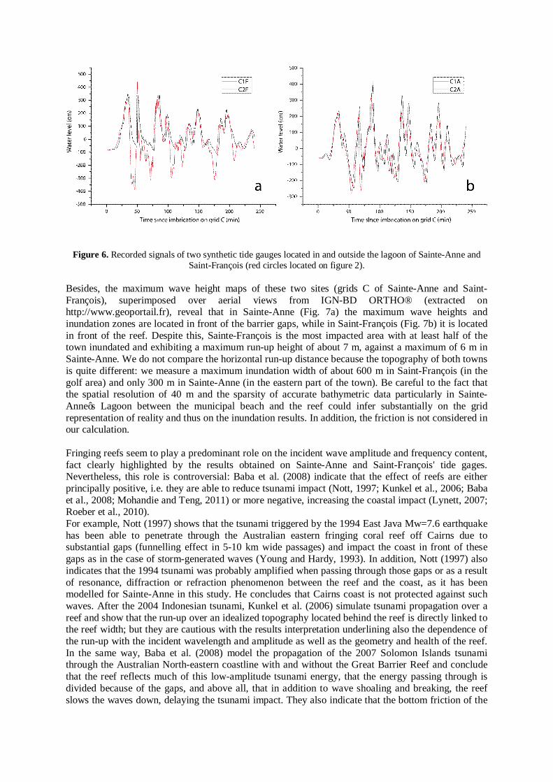
Figure 6. Recorded signals of two synthetic tide gauges located in and outside the lagoon of Sainte-Anne and Saint-François (red circles located on figure 2).
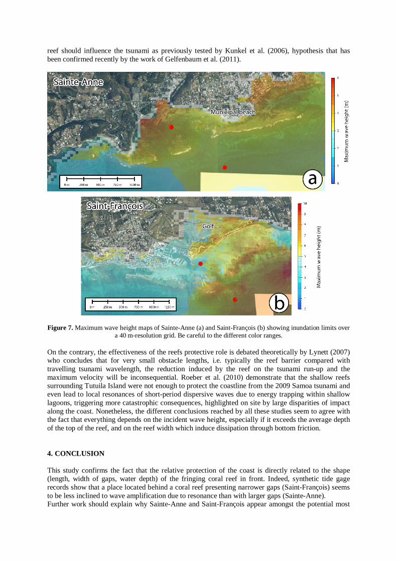
Besides, the maximum wave height maps of these two sites (grids C of Sainte-Anne and Saint-François), superimposed over aerial views from IGN-BD ORTHO® (extracted on http://www.geoportail.fr), reveal that in Sainte-Anne (Fig. 7a) the maximum wave heights and inundation zones are located in front of the barrier gaps, while in Saint-François (Fig. 7b) it is located in front of the reef. Despite this, Sainte-François is the most impacted area with at least half of the town inundated and exhibiting a maximum run-up height of about 7 m, against a maximum of 6 m in Sainte-Anne. We do not compare the horizontal run-up distance because the topography of both towns is quite different: we measure a maximum inundation width of about 600 m in Saint-François (in the golf area) and only 300 m in Sainte-Anne (in the eastern part of the town). Be careful to the fact that the spatial resolution of 40 m and the sparsity of accurate bathymetric data particularly in Sainte-Anne’s Lagoon between the municipal beach and the reef could infer substantially on the grid representation of reality and thus on the inundation results. In addition, the friction is not considered in our calculation. Fringing reefs seem to play a predominant role on the incident wave amplitude and frequency content, fact clearly highlighted by the results obtained on Sainte-Anne and Saint-François' tide gages. Nevertheless, this role is controversial: Baba et al. (2008) indicate that the effect of reefs are either principally positive, i.e. they are able to reduce tsunami impact (Nott, 1997; Kunkel et al., 2006; Baba et al., 2008; Mohandie and Teng, 2011) or more negative, increasing the coastal impact (Lynett, 2007; Roeber et al., 2010). For example, Nott (1997) shows that the tsunami triggered by the 1994 East Java Mw=7.6 earthquake has been able to penetrate through the Australian eastern fringing coral reef off Cairns due to substantial gaps (funnelling effect in 5-10 km wide passages) and impact the coast in front of these gaps as in the case of storm-generated waves (Young and Hardy, 1993). In addition, Nott (1997) also indicates that the 1994 tsunami was probably amplified when passing through those gaps or as a result of resonance, diffraction or refraction phenomenon between the reef and the coast, as it has been modelled for Sainte-Anne in this study. He concludes that Cairns coast is not protected against such waves. After the 2004 Indonesian tsunami, Kunkel et al. (2006) simulate tsunami propagation over a reef and show that the run-up over an idealized topography located behind the reef is directly linked to the reef width; but they are cautious with the results interpretation underlining also the dependence of the run-up with the incident wavelength and amplitude as well as the geometry and health of the reef. In the same way, Baba et al. (2008) model the propagation of the 2007 Solomon Islands tsunami through the Australian North-eastern coastline with and without the Great Barrier Reef and conclude that the reef reflects much of this low-amplitude tsunami energy, that the energy passing through is divided because of the gaps, and above all, that in addition to wave shoaling and breaking, the reef slows the waves down, delaying the tsunami impact. They also indicate that the bottom friction of the
reef should influence the tsunami as previously tested by Kunkel et al. (2006), hypothesis that has been confirmed recently by the work of Gelfenbaum et al. (2011).
Figure 7. Maximum wave height maps of Sainte-Anne (a) and Saint-François (b) showing inundation limits over
a 40 m-resolution grid. Be careful to the different color ranges. On the contrary, the effectiveness of the reefs protective role is debated theoretically by Lynett (2007) who concludes that for very small obstacle lengths, i.e. typically the reef barrier compared with travelling tsunami wavelength, the reduction induced by the reef on the tsunami run-up and the maximum velocity will be inconsequential. Roeber et al. (2010) demonstrate that the shallow reefs surrounding Tutuila Island were not enough to protect the coastline from the 2009 Samoa tsunami and even lead to local resonances of short-period dispersive waves due to energy trapping within shallow lagoons, triggering more catastrophic consequences, highlighted on site by large disparities of impact along the coast. Nonetheless, the different conclusions reached by all these studies seem to agree with the fact that everything depends on the incident wave height, especially if it exceeds the average depth of the top of the reef, and on the reef width which induce dissipation through bottom friction. 4. CONCLUSION This study confirms the fact that the relative protection of the coast is directly related to the shape (length, width of gaps, water depth) of the fringing coral reef in front. Indeed, synthetic tide gage records show that a place located behind a coral reef presenting narrower gaps (Saint-François) seems to be less inclined to wave amplification due to resonance than with larger gaps (Sainte-Anne). Further work should explain why Sainte-Anne and Saint-François appear amongst the potential most
impacted places in Guadeloupe, whatever the source location. This fact should be taken into consideration for tsunami hazard mitigation, as well as the role played by resonance within the lagoon of these two touristic coastal places. ACKNOWLEDGEMENT This work has been funded by the INTERREG IV TSUNAHOULE project managed by the Laboratoire de Recherche en Géosciences et Energies (University of the Antilles and French Guyana). We would like to thank Vasily Titov (NOAA) for sharing ComMIT software. REFERENCES Accary, F. & Roger, J. (2010). Tsunami catalog and vulnerability of Martinique (Lesser Antilles, France).
Science of Tsunami Hazards, 29:3, 148-174. Baba, T., Mleczko, R., Burbidge, D., Cummins, P.R. & Thio, H.K. (2008). The effect of the Great Barrier Reef
on the propagation of the 2007 Solomon Islands tsunami recorded in Northeastern Australia. Pure and Applied. Geophysics, 165, 2003-2018.
Bernard, P. & Lambert, J. (1988). Subduction and seismic hazard in the Northern Lesser Antilles: revision of the historical seismicity. Bull. Seismol. Soc. Am., 78:6, 1965-1983.
Blanc, P.-L. (2011). The Atlantic tsunami on November 1st, 1755: world range and amplitude according to primary documentary sources. The tsunami threat - Research and Technology, InTech, 423-446.
DeMets, C., Mattioli, G., Jansma, P., Rogers, R.D. & Tenorio, C. (2007). Present motion and deformation of the Caribbean plate: constraints from new GPS geodetic measurements, from Honduras and Nicaragua. In Mann, P., ed., Geologic and Tectonic Development of the Caribbean Plate in Northern Central America: Geological Society of America, Special Paper 428, p. 21–36, doi: 10.1130/2007.2428(02).
Feuillet, N., Beauducel, F. & Tapponnier, P. (2011). Tectonic context of moderate to large historical earthquakes in the Lesser Antilles and mechanical coupling with volcanoes. Journal of Geophysical Research, 116:B10308, doi: 10.1029/2011JB008443.
Gelfenbaum, G., Apotsos, A., Stevens, A.W. & Jaffe, B. (2011). Effects of fringing reefs on tsunami inundation: American Samoa. Earth-Science Reviews, 107, 12-22.
Gusiakov, V.K. (1978). Static displacement on the surface of an elastic space. Ill-posed problems of mathematical physics and interpretation of geophysical data, Novosibirsk, VC SOAN SSSR, 23–51 (in Russian).
Kunkel, C.M., Hallberg, R.W. & Oppenheimer, M. (2006). Coral reefs reduce tsunami impact in model simulations. Geophysical Research letters, 33:L23612, doi: 10.1029/2006GL027892.
Lynett, P.J. (2007). Effect of a shallow water obstruction on long wave runup and overland flow velocity. Journal of Waterways, Port, Coastal, and Ocean Engineering, 133:6, 455-462.
Mohandie, R. & Teng, M.H. (2011). Numerical and experimental study on reducing long wave run-up by beach vegetation. Twenty-first International Offshore and Polar Engineering Conference, Maui, Hawaii, USA, June 19-24. ISBN: 978-1-880653-96-8
Nott, J. (1997). Extremely high-energy wave deposits inside the Great Barrier Reef, Australia: determining the cause - tsunami or tropical cyclone. Marine Geology, 141, 193-207.
O'Loughlin, K.F. & Lander, J.F. (2003). Caribbean tsunamis: A 500-year history from 1498-1998. Kluwer Academic Publishers, Dordrecht, The Netherlands.
Okada, Y. (1985). Surface deformation due to shear and tensile faults in a half-space. Bull. Seismol. Soc. Am., 75, 1135–1154. Roeber, V., Yamazaki, Y. & Cheung, K.F. (2010). resonance and impact of the 2009 Samoa tsunami around
Tutuila, American Samoa. Geophysical Research Letters, 37:L21604, doi: 10.1029/2010GL044419. Roger, J., Allgeyer, S., Hébert, H., Baptista, M.A., Loevenbruck, A. & Schindelé, F. (2010a). The 1755 Lisbon
tsunami in Guadeloupe Archipelago : source sensitivity and investigation of resonance effects . The Open Oceanography Journal, 4, 58-70.
Roger, J., Baptista, M.A., Sahal, A., Allgeyer, S. & Hébert, H. (2010b). The transoceanic 1755 Lisbon tsunami in the Martinique. Pure and Applied Geophysics, International Tsunami Symposium, Novosibirsk, Russia, July 2009, 168:6-7, 1015-1031.
Service Hydrographique et Océanographique de la Marine (1994). Guadeloupe. De Montserrat à Marie-galante. Echelle 1:149000. n°7345.
Titov, V.V., Moore, C.W., Greenslade, D.J.M., Pattiaratchi, C., Badal, R., Synolakis, C.E. & Kanoglu, U. (2011). A new tool for inundation modeling: Community Model Interface for Tsunamis (ComMIT). Pure and Applied Geophysics, 168:11, 2121-2131.

Titov, V.V. & Gonzalez, F.I. (1997). Implementation and testing of the Method Of Splitting Tsunami (MOST). NOAA Technical Memorandum ERL PMEL-112, contribution 1927, 14 pp.
Titov, V.V. & Synolakis, C.E. (1995). Modeling of breaking and nonbreaking long wave evolution and runup using VTCS-2. J. Waterways, Ports, Coastal and Ocean Engineering, 121:6, 308-316.
Young, I.R. & Hardy, T.A. (1993). Measurement and modelling of tropical cyclone waves in the Great Barrier Reef. Coral Reefs, 12, 85-95.
Zahibo, N. & Pelinovsky, E.N. (2001). Evaluation of tsunami risk in the Lesser Antilles. Natural Hazards and Earth System Sciences, 1, 221-231.
Zahibo, N., Pelinovsky, E.N., Okal, E., Yalciner, A., Kharif, C., Talipova, T. & Kozelkov, A. (2005). The earthquake and tsunami of November 21, 2004 at Les Saintes, Guadeloupe, Lesser Antilles. Science of Tsunami Hazards, 23:1, 25-39.
Zahibo, N., Pelinovsky, E., Yalciner, A.C., Kurkin, A., Koselkov, A. & Zaitsev, A. (2003). The 1867 Virgin Island tsunami. Natural Hazards and Earth System Sciences, 3, 367-376.
Zahibo, N., Pelinovsky, E., Yalciner, A., Zaitsev, A., Talipova, T., Nikolkina, I. & Chernov, A. (2011). Trans-Atlantic propagation of 1755 tsunami and its effects on the French West Indies. The Open Oceanography Journal, 5, 30-41.