trip report: usfws tour of aquatic, wetland and riparian ... report: usfws tour of aquatic, wetland...
TRANSCRIPT

Trip Report: USFWS Tour of Aquatic, Wetland and
Riparian Areas within the LCNCA Jeff Simms, Fishery Biologist, Gila District
The BLM provided a tour of aquatic resources for the USFWS, Ecological Services on Empire
Spring and Cienega Creek on June 23, 2014. Participants included Steve Spangle, Jean Calhoun,
Julie Crawford, Susan Sferra, and Marcia Radke (BLM) and myself.
The purpose of the tour was to show Service staff the aquatic resources and current conditions of
aquatic habitat on the LCNCA for purposes related to Section 7 consultations with the USFS on
the Rosemont Mine project.
We gathered at the Empire Ranch at about 7am. The agenda was to visit the following locations:
1. Empire Spring
2. Cienega Ranch Wetland
3. Cienega Creek below the LC6901 cement stream crossing
4. Cienega Creek at the power line crossing
5. Cienega Creek below Cold Water Spring (Fresno Gap)
6. Empire Gulch near the confluence with Cienega Creek
7. Cieneguita Wetland restoration area
8. Cienega Creek above Gardner Canyon
9. Empire Wildlife Pond
The first stop was Empire Spring. The group walked from the parking lot to the spring source.
This area had a continuous ribbon of surface water. We observed willow flycatcher habitat (yew
leaf willow). Marcia Radke bands birds at this location and had heard willow flycatchers here
earlier in the month. We also looked at older cottonwood and mesquite woodlands that comprise
yellow-billed cuckoo habitat which is currently occupied by this bird. Although no Huachuca
water umbel occurs here, the habitat appeared conducive to this plant. The aquatic habitat was
flowing, but choked with duck weed, beggar’s tick (Bidens sp.) and watercress. A few leopard
frogs were observed. We looked at the headcut erosion at the spring source as well. I discussed
the fencing and past grazing management that has led to the riparian conditions we see today.
Points made at this location:
No tree regeneration upstream of the headcut as the elevation difference is 6+ feet, which
means the ground water elevations are too deep to support germinating or sapling trees.
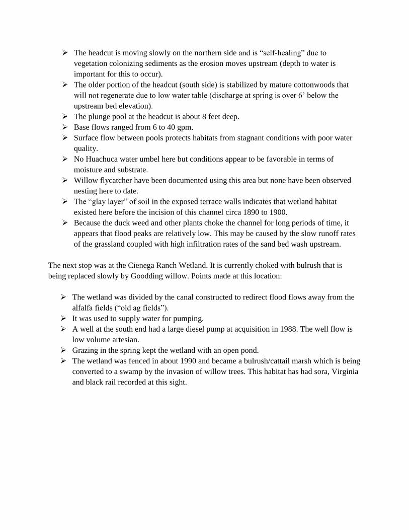
The headcut is moving slowly on the northern side and is “self-healing” due to
vegetation colonizing sediments as the erosion moves upstream (depth to water is
important for this to occur).
The older portion of the headcut (south side) is stabilized by mature cottonwoods that
will not regenerate due to low water table (discharge at spring is over 6’ below the
upstream bed elevation).
The plunge pool at the headcut is about 8 feet deep.
Base flows ranged from 6 to 40 gpm.
Surface flow between pools protects habitats from stagnant conditions with poor water
quality.
No Huachuca water umbel here but conditions appear to be favorable in terms of
moisture and substrate.
Willow flycatcher have been documented using this area but none have been observed
nesting here to date.
The “glay layer” of soil in the exposed terrace walls indicates that wetland habitat
existed here before the incision of this channel circa 1890 to 1900.
Because the duck weed and other plants choke the channel for long periods of time, it
appears that flood peaks are relatively low. This may be caused by the slow runoff rates
of the grassland coupled with high infiltration rates of the sand bed wash upstream.
The next stop was at the Cienega Ranch Wetland. It is currently choked with bulrush that is
being replaced slowly by Goodding willow. Points made at this location:
The wetland was divided by the canal constructed to redirect flood flows away from the
alfalfa fields (“old ag fields”).
It was used to supply water for pumping.
A well at the south end had a large diesel pump at acquisition in 1988. The well flow is
low volume artesian.
Grazing in the spring kept the wetland with an open pond.
The wetland was fenced in about 1990 and became a bulrush/cattail marsh which is being
converted to a swamp by the invasion of willow trees. This habitat has had sora, Virginia
and black rail recorded at this sight.

Photograph of Cienega Ranch Wetland showing bulrush and Goodding willow mix. The wetland
is becoming a swamp habitat type as willows move into habitat occupied by herbaceous
vegetation.
We then walked up Cienega Creek to look at channel conditions. It is currently very dry.
Points made at this location:
The creek here only runs with base flow in the winter and early spring if we get
precipitation and during the summer monsoons.
As we walked downstream the channel was bordered by deer grass in poor health and
dead and dying willow trees.
Ash trees were coming in and will likely replace cottonwoods and willows as they are
able to flourish under dryer conditions.
The basin fill here is 800 feet or more deep which requires a lot of recharge to fill the
aquifer to the point it meets the channel elevation. This had occurred in the 1980s.
Enough water here in the 1980s and early 1990s to fill three ponds for irrigation. These
ponds held Gila topminnow and Gila chub.
All three were removed and the canal plugged. This allowed both base flows and flood
flows to come through the reach.
Incision (~7 ft deep) was observed about ¼ mile north of the cement crossing.

This segment was part of a stream restoration project completed in 1998. The stream
restoration included a cement crossing with footers 11 feet deep in case the reach should
ever experience accelerated erosion. This will protect the stream from the progression of
the head cut by acting as a man-made geologic control.
Through the ag fields reach, it will take decades for the process of channel evolution
(deepening, widening, establishment of a new floodplain adjacent to the channel). This
will be entirely dependent on sufficient moisture (surface water) for riparian plant
development.
Current riparian function is low and declining with the channel turning into a wash
(likely has entered the “nonfunctional” PFC category).
Roots that once held the fine soils in the bed and bank now stranded in the air creating a
web or “hammock”. Loss of soil stability occurs with the loss of root systems.
If the mine adds to the drawdown, then the reach will get dryer and riparian function will
likely decline further upstream and downstream.
May lose Cienega Ranch Wetland if there is added drawdown from the mine or other
sources.
Photograph showing headcut and tree roots that once stabilized the stream bed are now
suspended in the air. This reach has dead and dying trees and deer grass suggesting that its
new state will be an ephemeral wash.

Mr. Spangle asked about the solution for the erosion problem. Answer – The solution is
stream restoration as long as there is enough moisture. Under current conditions this reach is
becoming an ephemeral wash (PFC rating has changed and is likely “non-functional”).
Mr. Spangle asked, what are the factors for the aquifer decline in this reach? Answer - there
was enough water to fill 3 ponds for irrigation, historically. It appears that climate and
expansion of ground water pumping are causes. There is a belt of private land between the
FS boundary and the BLM with ranchettes supporting ponds, orchards and gardens.
We proceeded to the north end of the NCA at a ford below the high tension power lines. We
walked about ½ mile of the creek. Points made at this location:
Huachuca water umbel is abundant here.
Most of the HWU was wilted or brown and dead.
No flowing water observed.
Pools very low, down about 3-4 ft. Only about 1ft of water or less remaining in most of
them.
Not sure if pools would have water next week as they had diminished since the wet-dry
10 days earlier.
A leopard frog was observed.
Gila topminnow, Gila chub and longfin dace were observed in some pools.
One pool was stagnant with tea colored water. It had the characteristic crust of diatoms
(unicellular algae) covering the water’s surface. Diatoms store energy as oil. When they
die, they release the oil creating a telltale “sheen.”
I mentioned that downstream about 1 mile of riparian habitat had been lost resulting in 2
headcuts.
Below the crossing, there were no pools observed where several were observed for the
annual wet-dry inventory. These pools had supported Gila topminnow, Gila chub and
longfin dace. They are now gone.
The reach below the ford has the largest HWU patches inventoried on the creek in 2011.
These patches were hard to locate because they were wilted or brown (dead).
Plants growing across the channel bottom due to the higher soil moisture and lack of
flowing water.
A riparian photopoint t-post was located. It was only sticking up about 18 inches
(originally 5 ft in 1989) demonstrating sediment accumulation from riparian plants
changing sediment transport (bank building).
Rising banks help with aquifer recharge as the floodplain is inundated more frequently.

Photograph showing Julie Crawford (Botanist, FWS) placing flags around HWU patch that is
in poor condition from desiccation.

We proceeded to Fresno Gap where Mattie Canyon and Cold Water Spring join Cienega
Creek. All the trees and other vegetation looked green and healthy. Points made at this
location:
Flow was strong (about 0.25 cfs).
Large pools had abundant populations of Gila topminnow, Gila chub, and longfin dace.
Several young leopard frogs (Chiricahua) produced from a release made in previous years
were observed.
Wetland at Cold Spring Seep is expanding as evidenced by dead mesquites that “drown”
in wet soils and the extensive spread of yerba-mansa (characteristic wetland plant).
Channel and expansive floodplain are well connected and floods frequently inundate the
floodplain.
Floodplain elevation allows for frequent flooding and expansive size allows for large
amounts of recharge.
Cows kept out by previous rancher going as far back as 1988 (maybe longer), leaving
vegetation to grown to its full potential. This stabilized the soils and allowed for channel
roughness that facilitated deposition and channel/floodplain equilibrium to be maintained.
This reach is the best example of a stream flowing through a cienega (wetland) in the
LCNCA. It is functioning at or near full potential.
Most of the water here comes from Cold Water Spring.
This is where Susan Sferra with the USFWS broke her leg at the ankle. We rendered first aid and
walked her back to the truck (~1/4 mile).
We departed for the Empire Ranch. We stopped briefly at Empire Pond located next to Empire
Gulch. Gila topminnow, desert pupfish, northern Mexican gartersnake and Chiricahua leopard
frogs occupy this pond. Replacement waters (galvanized steel troughs) are located below this
location next to the well.

Photograph of Empire Wildlife Pond located 2.7 miles above Empire Spring. The artificial pond
supports new populations of Gila topminnow, desert pupfish, Chiricahua leopard frog, and
northern Mexican gartersnakes.
Final note: Not all areas on the agenda were visited due to various circumstances. We missed
Empire Gulch near the confluence with Cienega Creek, Cieneguita Wetland restoration area, and
the portion of Cienega Creek above Gardner Canyon. The tour went well and Mr. Spangle
thanked me. The hydrograph, which is an indicator of ground water elevation flux is presented in
appendix A. Additional picture taken on the tour can be found in the appendix B.
Appendix A
USGS Hydrographs for Cienega Creek showing flows from June 1 to July 10, 2014.
The second hydrograph is from June 30th to July 6th
.
Note date of tour has a blue arrow. The low flow for June 30th
and July 1st was at or near 0.0 for
a time as indicated by the red arrow. Some of the days did not follow the daily pattern wide
swings in flow, as cloudy days usually result in median flows that are greater than typical as a
result of lower ET rates. The second graph shows more clearly the lowest flow situation.


Appendix B Photographs from tour and annual surface water monitoring (wet-dry)
of Cienega Creek on 06-12-2014
Tour photographs
Photo of head spring at Empire Spring located in Empire Gulch near the historic Empire Ranch.
This pool is relatively stable due to riparian plants that provide a root structure that is erosion
resistant and water shed function which produces relatively low peak floods as inferred from the
modest size of the woody debris located on the flood plain and lack of new erosion feature
following the monsoons. Note heavy vegetation on the surface of the pool.

Photograph of Cienega Creek channel just above the power line ford (northern end of LCNCA).
The stream channel is largely dry except for some residual pools. Vegetation condition shows
good vigor. Bank protection is excellent. However, aquatic habitat is lacking.

Photo is located a short distance above the previous one. Here Huachuca water umbels is
growing across the channel bottom where soil has the most moisture. Pin flags are being set by
Julie Crawford (FWS) to delineate an HWU patch. In this location the patch had live, wilted and
dead plants.

Photograph shows a pool typical in the stream reach above the Mattie Canyon Confluence. This
pool is 5+ feet deep.

Photo of conditions near the confluence of Cienega Creek and Mattie Canyon. Vegetation
condition shows good vigor. Bank protection is excellent. The herb growing at water’s edge is
water parsnip. The terrace in the background was part of the floodplain before incision that
began in the 1890s. Since then the channel and floodplain have evolved to a new equilibrium that
is stable.

Photo of conditions near the confluence of Cienega Creek and Mattie Canyon. Large pool 5+ feet
deep with longfin dace and Gila chub observed. These pools are common in this reach of
Cienega Creek. All pools were connected by runs with about ¼ cfs flow (estimated - not
measured).

Two photos showing floodplain-wetland conditions about ¼ miles upstream of the confluence of
Cienega Creek and Mattie Canyon. Vegetation condition shows good vigor, except mesquite
trees are dead from saturated soil conditions. This is common on the floodplain in this reach. The
herb is yerba mansa.

Photo of floodplain conditions about 2-300 yards downstream of the confluence of Cienega
Creek and Mattie Canyon. Vegetation condition shows good vigor. Sacaton grass, mesquite, and
hackberry occupy dryer portions of the floodplain, which is more than 200 yards wide. Such
large floodplains capture water that would otherwise end up downstream so it can be released
slowly to the channel. Notice that the fence posts are only about 2 feet above the surface.
Flooding over the last 20 to 25 years has allowed for deposition, whereby increasing aquifer
capacity.
Susan Sferra is being supported by Julie Crawford, as Susan had broken her leg just a short time
before this photo was taken. She fared well on the trip back to Tucson and received medical
treatment as soon as possible.

Wet-dry monitoring photographs taken on June 12th
(Power line ford to the Narrows).
This is one of the segments segment visited on the tour.
Only the upper end of the segment was visited.
Photo depicting dry reach between Fresno and Apache canyons. Formerly this reach had surface
water that supported Gila topminnow and longfin dace. Trees still have enough moisture to
remain healthy.

Photo of Sonora mud turtle moving through dry stream bed. Turtles in this situation are more
vulnerable to predation than those occupying pool habitat.
Photo of Huachuca water umbel in a moist stream bed that likely has surface flow at night when
plants are not using water (not transpiring). Aquatic plants in this situation are vulnerable to
desiccation should soil moisture drop further.

Photo of stream reach below the Narrows showing the conversion of the riparian plant
community (cottonwood, willow and ash) to one dominated by seep willow and other species
tolerant of dry conditions (xeroriparian).
The next 2 photo show stressed cotton woods, willow and ash trees. Seep willow is coming in on
ecological sites otherwise suitable for cottonwood and willow. Plant community is moving
towards a xeroriparian type. In the second photo cottonwood regeneration is occurring in the
stream bed where saplings are protected from flood scour.

The next 2 photo show headcutting (accelerated erosion) as a result of the loss of riparian plants
rom dry conditions. These 2 headcuts are located less than a quarter mile apart and 7 and 5 feet
deep, respectively. If they merge, the incision would be 12 feet deep.

Photo shows bank erosion as a result of the loss of riparian plants. On the right, a new strand of
willows has established in the bottom of the incised channel. The deergrass on the left is too far
removed from adequate soil moisture and is diminishing in vigor, thus unable to support root
systems that hold bank soil; this change is the result of incision.
The last group of habitat photos is comprised of remnant pool habitats. Some are nearing desiccation
while others appear deep enough to persist at least a few more weeks.


Photo showing stagnant conditions that are acute enough reduce fish survival. The “crust” is comprised
of diatoms (unicellular algae) that at the aggregate at the water’s surface under conditions of little or no
base flow. The algae store oil (lipids) as energy reserves that are released and cover the water surface
when they die. The oil acts as a barrier to gas exchange that limits oxygen levels in the water column.
Photo of fish and amphibians found in some of the remaining pools on June 12th. The species include
Gila chub, Gila topminnow and leopard frog tadpole (either Chiricahua or lowland). Longfin dace were
resent but illustrated in the photo.