trb lrt committee greg benz january 25, 2012. project history 1986 – montgomery county completes...
TRANSCRIPT

TRB LRT Committee
Greg Benz
January 25, 2012

Project History
• 1986 – Montgomery County completes feasibility study of using Georgetown Branch as transitway, subsequently purchases right-of-way
• 1990s – SHA begins Capital Beltway HOV Study, becomes Capital Beltway/Purple Line Study
• 1996 – MTA develops conceptual plans for transitway and trail, DEIS completed
• 2002 Capital Beltway/Purple Line Study recommends “Inner Purple Line” to provide a transportation alternative to the increasingly congested Capital Beltway
• 2002 – Georgetown Branch Study expanded east to New Carrollton; two projects: Purple Line East and Purple Line West
• 2003 – Two projects combined, renamed Bi-County Transitway, evaluation of BRT added
• 2007 returned to name “Purple Line”• 2008 Purple Line AA/DEIS Published with public hearings• 2009 Locally Preferred Alternative identified• October 7, 2011 – FTA Permission to Enter PE
2

Some More History
3
Former B&O Georgetown Branch
ROW- Western 3 miles of
project

4
Purple Line Locally Preferred Alternative
• 16-mile east-west light rail line between Bethesda and New Carrollton• Entire project inside the Washington Beltway• Connects major activity centers• Connects to:
– Metro’s Red, Green and Orange Line– All three MARC commuter rail lines, Amtrak and local bus services

• Provide faster and more reliable transit for the region’s east-west travel market
• Improve access and connectivity to:• Metrorail Red, Green and Orange lines• All three MARC commuter rail lines• Local Ride-on and “The Bus” service• Amtrak• Intercity bus services
• Increase service for transit-dependent populations
5
Project Goals and Benefits

• Improve connectivity and access to existing activity centers and planned development including:
• Bethesda• Silver Spring• Takoma/Langley Park• University of Maryland/College Park• New Carrollton
• Support local, regional and state policies and adopted Master Plans
• Strengthen and revitalize communities in the corridor• Increase potential for Transit Oriented Development at
existing and proposed stations in the corridor as identified in local land use plans
6
Project Goals and Benefits

Locally Preferred Alternative
• Twenty-one stations• LRV: 70% low-floor/ 30 m. car; limited to 2-cars • Service
– Headways: 6 minutes peak; 10 minutes off-peak– Meet first and last Metrorail trains
• Fare Policy: Metrorail bus
• Ridership: 60,000 daily riders– 30% will use Metro for part of their trip
• Cars off the road: 20,000 daily• Two maintenance and storage facilities • Capital Cost: $1.9 Billion (Year of Expenditure) 7

Political / Institutional Setting
• Multi-jurisdictional Project Corridor– Two counties (executives, legislatures, planning
commissions, DPW&Ts, etc.)– Four incorporated cities: Takoma Park, College Park,
Riverdale Park, and New Carrollton• Political Sensitivity
– Very visible– Elections– Established positions
• Sophisticated Stakeholder Groups• Multiple Transit Operators
8

Current Project Activities
• New Starts Funding– Approved by FTA for Entry into Preliminary
Engineering October 7, 2011– Medium-High Rating– 50% Federal Share
• Alignment refinement• Station design• Yard/shop siting• Coordination with counties, local municipalities,
State Highway Administration, and CSX9

Public Involvement
• Open houses• Community Focus Groups• Neighborhood Work Groups• Community and civic association meetings• Community outreach events
– Libraries, grocery stores, shopping centers • www.purplelinemd.com• Newsletters

Anticipated Project Schedule
Began PE and Final Environmental Fall 2011 Impact Statement
Complete PE and Final Environmental Impact Spring 2013Statement
Begin Final Design Summer 2013
Construction Begins 2015
11

Travel Market Problems and Purpose
• Problem High ridership on slow, disjointed bus routes– Degraded mobility & accessibility between major
activity centers and residential areas– Degraded transit accessibility between corridor and
the larger metropolitan region due to inferior connections to radial Metrorail lines and other rail and bus services
• Purpose Improve travel times between corridor land uses and Metrorail services with dedicated / exclusive guideway

Context
• Established inner ring suburbs– Mix of residential, commercial and institutional land uses – Key employment and activity centers: Bethesda, Silver Spring,
Takoma/Langley Park, University of Maryland/College Park, and New Carrollton
• Major transportation routes generally radial– Limited continuous major east-west arterials & bus routes
• High levels of congestion– Most Intersections operate at LOS E/F– Many bus routes operate slower than 10 mph
• Limited opportunities to expand roadway capacity• Heavy transit usage on Metrorail and Bus

Context / Activity Levels - 2005
• Employment– Corridor employment 201,000– DC employment 736,400
Comparable CBD Employment Denver – 126,000
Seattle – 155,100
Boston – 257,000
• Population– Corridor residents 280,600– Large transit-dependent population
• 12.4% zero car households

Context / Transit Services
Transit Usage• Four radial Metrorail routes/stations
– Red Line-west leg: Bethesda & Medical Center– Red Line-east leg: Silver Spring (also MARC)– Green Line: College Park (also MARC)– Orange Line: New Carrollton (also MARC/AMTRAK)– East-west trips on Metrorail require users to go into and out of
DC• Buses
– Ride On– The Bus– WMATA– U of Maryland Shuttle (over 750 buses/day in corridor)– 75 bus routes in corridor– Only 12 provide E-W service – some E-W routes are the
busiest in system– No 1-seat ride for length of corridor

Current Conditions
Slow Transit Travel Times• Disjointed Roadway System
– Few continuous major east-west arterials
• High Congestion Level– Slow speeds; intersections at dominant radial arterials
• Existing Bus Routes – Operate over this roadway system– Low operating speeds– Speeds: many below 10 mph– Disjointed service along corridor due to local service providers

How Conditions Change by 2030
2030 Corridor
Corridor Growth from
2005
2030 Total Region
Regional Growth from
2005
Employment 223,864 +11% 4,667,981 +26%
Residents 335,322 +19% 7,668,921 +22%
Households 128,622 +21% 2,935,720 +25%
• Demographic Growth
– Major employment growth in Bethesda and College Park– Major residential growth in Bethesda, Silver Spring and
College Park

Conditions in 2030
Transit Conditions• Roadway system on which buses operate
increases in congestion levels– Peak auto trip from UM to Silver Spring increases from 24 minutes to 37
minutes; Bethesda to Silver Spring from 14 minutes to 21 minutes
• No roadway capacity increases• Lower operating speeds• Increasing demand for transit
– Population and employment growth– Degraded roadway travel times

Purpose of Improvement Alternatives
Improve Travel Times For• Travel within the corridor
– Major activity centers– Adjacent communities
• Travel from corridor to areas outside – Feeding to and distributing passengers from radial corridors via
Metrorail/MARC– Especially to DC
• Travel to corridor from areas outside – Especially north and east of corridor– Along Metrorail lines and major arterials

Markets and General Observations
• Three Predominant Markets– Within the Corridor (52% of the benefits)– From the Corridor (19% of the benefits)– To the Corridor (26% of the benefits)– Un-related to Corridor (3% of the benefits)
• Percent of Benefits by Trip Purpose– HBW 58% – HBO 21%– NHB 21%

Largest User Benefit Production- Attraction (I-J) Pair
Bethesda Silver SpringIn-vehicle Time Comparison
• By Bus 40.3 minutes• By Metrorail 34.4 minutes• By Purple Line 8.5 minutes

Notable Construction Elements
• Bethesda Station/Trail w/South Metro Entrance• CSX/Metrorail Crossing & SSTC Station• Silver Spring Library Station• Manchester Station/Tunnel• Takoma-Langley Park Transit Center• College Park Metro Station• LRV Storage & Maintenance Facilities• UM Alignment & EMI• New Carrollton TOD
22

Bethesda Terminal/Trail with South Metro Entrance
23

Bethesda Terminal/Trail with South Metro Entrance
24

CSX/Metrorail Crossing & Silver Spring Transit Center Station
25

Silver Spring Transit Center Station
26

Silver Spring Library Station
27
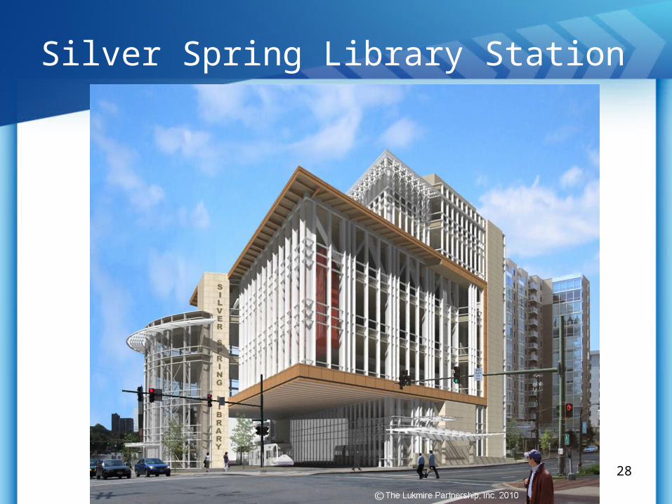
Silver Spring Library Station
28

Manchester Station / Tunnel
29

Planned Takoma-Langley Transit Center
30

Planned Takoma-Langley Transit Center

LRV Storage & Maintenance Facilities
32
Lyttonsville Site
Glenridge Site

University of Maryland Alignment/Stations
33
UM

1-8-201034
University of Maryland
Split Wire “High-Low” Power Supply

College Park Metrorail/MARC Station
35
Opportunities• Metrorail station• MARC station• Bus interface• Development activity
Challenges• Existing facilities• TOD proximity• Operational needs

College Park Metrorail/MARC Station
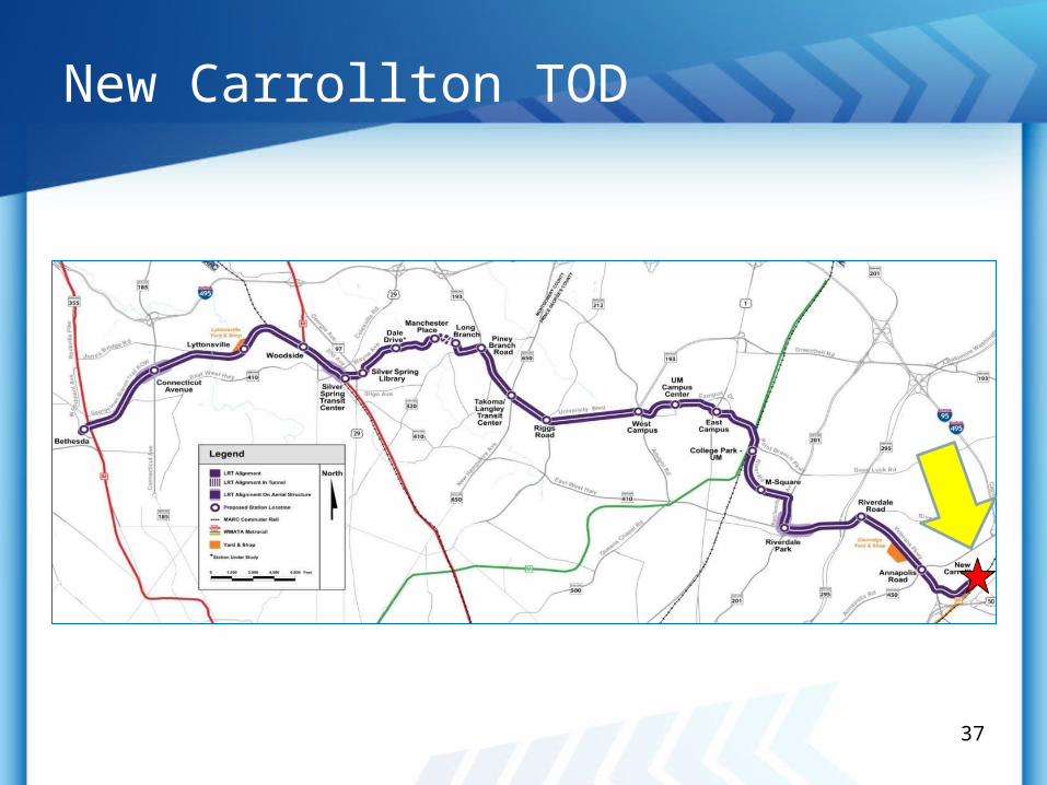
New Carrollton TOD
37

New Carrollton TOD
38

Mr. Michael MaddenProject Manager
Maryland Transit Administration6 Saint Paul Street
Baltimore, MD 21202410-767-3694
[email protected] www.purplelinemd.com
En Español:
Carlos Abinader
(301) 577-2063
For media inquiries contact:
Terry Owens
Director, MTA Office of Media Relations
410-767-3932