transport assessment addendum
TRANSCRIPT
Martin Andrews Consulting Limited | 8 Corn Kiln Close, Cogenhoe, NN7 1NX T: 01604 340544 | E: info@mac‐ltd.co.uk | W: mac‐ltd.co.uk
Transport Assessment
Addendum
Proposed Residential Development Land north of Hookhams Lane
Salph End Bedford
Revision 0: June 2018
Report Reference: 248‐TA‐02‐0
Transport Assessment Addendum Land off north of Hookhams Lane, Salph End
Martin Andrews Consulting Ltd i Revision 0 – June 2020 248‐TA‐02‐0
Report Originator(s) Martin Andrews MEng (Hons) CEng MICE MCIHT Director martin.andrews@mac‐ltd.co.uk
Revision Record
Revision Date Description Written Approved
0 12/06/20 Draft issue MJA MJA
0 16/06/20 Updated following comments from ARP MJA MJA

Transport Assessment Addendum Land off north of Hookhams Lane, Salph End
Martin Andrews Consulting Ltd ii Revision 0 – June 2020 248‐TA‐02‐0
Contents 1.0 Introduction .................................................................................................................... 1
1.1 Planning Context ..................................................................................................................... 1
2.0 Site Access ....................................................................................................................... 1
3.0 Accident Data .................................................................................................................. 2
3.1 Introduction ............................................................................................................................. 2
3.2 Junction 1: Hookhams Lane / Norse Road ............................................................................... 2
3.3 Junction 2: Wentworth Drive / Putnoe Lane ........................................................................... 3
3.4 Junction 3: A4280 St Neots Road / A4280 Goldington Road / Norse Road............................. 3
3.5 Junction 4: A421 / St Neots Road / A4280 .............................................................................. 4
3.6 Junction 5: Ravensden Rd / Oldways Rd / Church End ............................................................ 4
3.7 Summary .................................................................................................................................. 5
4.0 Traffic Analysis for Junctions ........................................................................................... 6
4.1 Introduction ............................................................................................................................. 6
4.2 Junction 2: Wentworth Drive / Putnoe Lane ........................................................................... 6
4.3 Junction 4: A421 / St Neots Road / A4280 .............................................................................. 6
5.0 Access to Local Amenities ................................................................................................ 7
5.1 Introduction ............................................................................................................................. 7
5.2 Existing footway provision ....................................................................................................... 7
5.3 Village Hall and Renhold Primary School ................................................................................. 8
5.4 Nursery .................................................................................................................................... 8
5.5 Mark Rutherford Secondary School ........................................................................................ 8
5.6 Summary .................................................................................................................................. 9
6.0 Conclusion ...................................................................................................................... 10
6.2 Access .................................................................................................................................... 10
6.3 Accident Analysis ................................................................................................................... 10
6.4 Traffic Analysis for Junctions ................................................................................................. 11
6.5 Access to Local Amenities ...................................................................................................... 11
Transport Assessment Addendum Land off north of Hookhams Lane, Salph End
Martin Andrews Consulting Ltd iii Revision 0 – June 2020 248‐TA‐02‐0
Appendices Appendix A ............................................................................................................................... A
Highway Authority Objection – 1st June 2020 .................................................................................. A
Appendix B ............................................................................................................................... B
Hookhams Lane Access ...................................................................................................................... B
MAC drawing no. 248‐TA11C ............................................................................................................. B
and ..................................................................................................................................................... B
Ravensden Road Access ..................................................................................................................... B
MAC drawing no. 248‐TA12C ............................................................................................................. B
Appendix C ................................................................................................................................ C
Road Safety Audit: Hookhams Lane ................................................................................................... C
Appendix D ............................................................................................................................... D
MAC Transport Assessment (Rev B): Accident Data Review ............................................................ D
Appendix E .................................................................................................................................E
Full Accident Data .............................................................................................................................. E
Appendix F ................................................................................................................................. F
J1: Hookhams Lane / Norse Road: Cycleway Improvements ............................................................ F
MAC drawing no. 248‐TA18 ............................................................................................................... F
Appendix G ............................................................................................................................... G
J5: Ravensden Road / Oldways / Church End: Existing Visibility ...................................................... G
MAC drawing no. 248‐TA16 .............................................................................................................. G
Appendix H ............................................................................................................................... H
Pedestrian and Cyclist Routes to Key Facilities with Improvements ................................................ H
MAC drawing no. 248‐TA03 .............................................................................................................. H
Appendix I .................................................................................................................................. I
Footway Improvements: Ravensden Road ......................................................................................... I
MAC drawing no. 248‐TA17 ................................................................................................................ I
Appendix J ................................................................................................................................. J
Footway Improvements – South of 43 Hookhams Lane ..................................................................... J
MAC drawing no. 248‐TA15A .............................................................................................................. J

Transport Assessment Addendum Land off north of Hookhams Lane, Salph End
Martin Andrews Consulting Ltd 1 Revision 0 – June 2020 248‐TA‐02‐0
1.0 Introduction
1.1 Planning Context
1.1.1 This Transport Assessment Addendum has been prepared in response to the Local
Highway Authority’s comments on MAC Transport Assessment (248‐TA‐01‐B, March
2020).
1.1.2 The highway authority objection dated 1st June 2020 is enclosed in Appendix A. This
Addendum should be read in conjunction with the Transport Assessment.
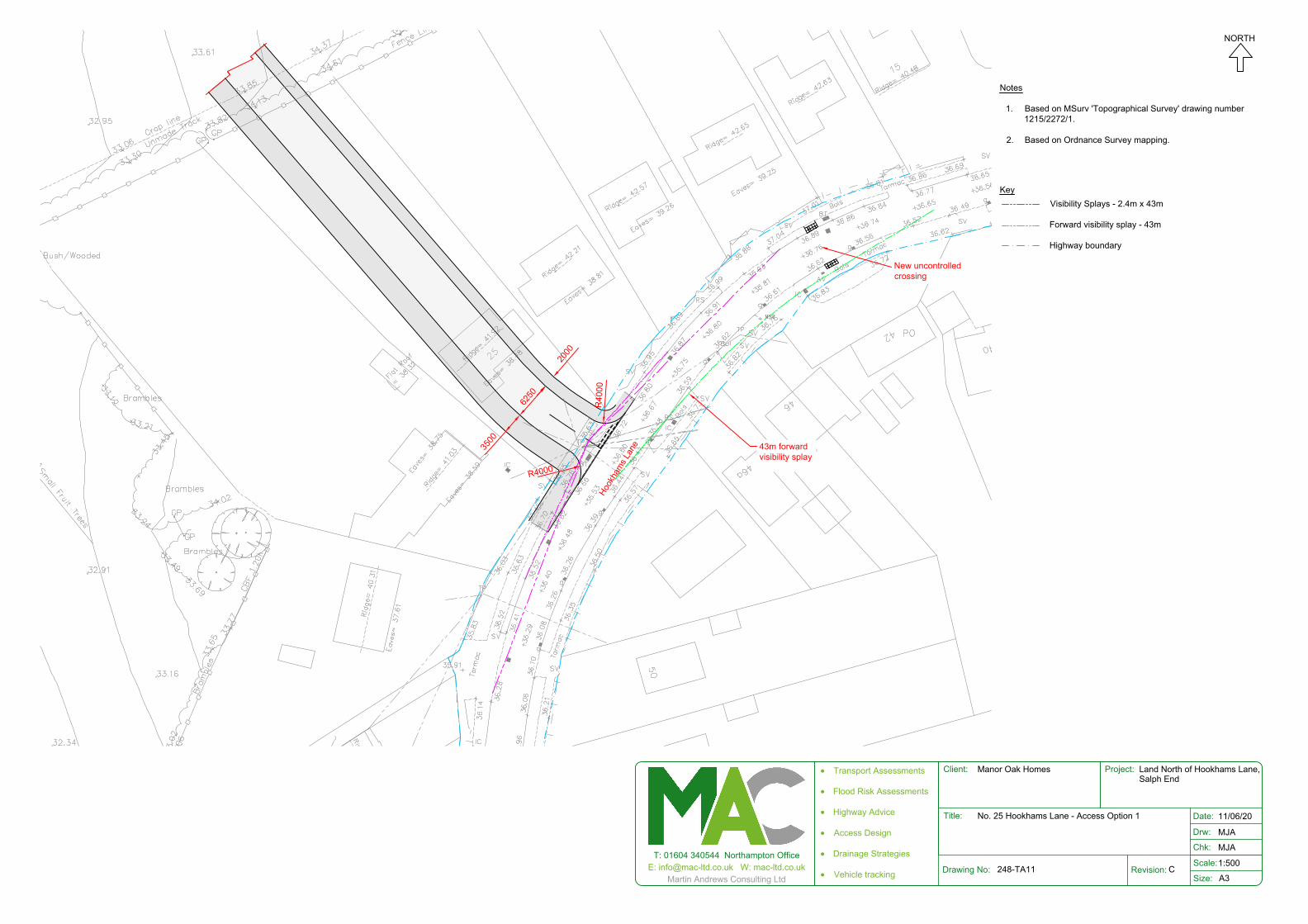
2.0 Site Access
2.1.1 As per the Transport Assessment Revision B, the proposed development will provide two
number all movement accesses off Hookhams Lane and Ravensden Road. The proposed
accesses are shown on the drawings enclosed in Appendices B.
2.1.2 The proposed Hookhams Lane access has been subject to a Stage 1 Road Safety Audit
(RSA), see Appendix C. The RSA did not raise any significant concerns which could not be
addressed at detailed design stage.
2.1.3 A planning application at 27 Hookhams Lane for 14 dwellings, planning reference
18/02496/MAF was recently refused. A new revised planning application, ref
20/00349/MAF, for 13 dwellings was submitted after this planning application for 400
dwellings. Therefore, the adjacent development has no planning status and both
developments need to be considered on their own merits.
Transport Assessment Addendum Land off north of Hookhams Lane, Salph End
Martin Andrews Consulting Ltd 2 Revision 0 – June 2020 248‐TA‐02‐0
3.0 Accident Data
3.1 Introduction
3.1.1 For ease of reference the full Transport Assessment review of the accident data is
enclosed in Appendix D with the full data enclosed in Appendix E
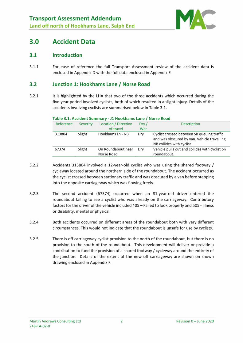
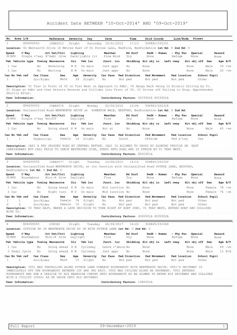
3.2 Junction 1: Hookhams Lane / Norse Road
3.2.1 It is highlighted by the LHA that two of the three accidents which occurred during the
five‐year period involved cyclists, both of which resulted in a slight injury. Details of the
accidents involving cyclists are summarised below in Table 3.1.
Table 3.1: Accident Summary ‐ J1 Hookhams Lane / Norse Road Reference Severity Location / Direction
of travel Dry / Wet
Description
313804 Slight Hookhams Ln ‐ NB Dry Cyclist crossed between SB queuing traffic and was obscured by van. Vehicle travelling NB collides with cyclist.
67374 Slight On Roundabout near Norse Road
Dry Vehicle pulls out and collides with cyclist on roundabout.
3.2.2 Accidents 313804 involved a 12‐year‐old cyclist who was using the shared footway /
cycleway located around the northern side of the roundabout. The accident occurred as
the cyclist crossed between stationary traffic and was obscured by a van before stepping
into the opposite carriageway which was flowing freely.
3.2.3 The second accident (67374) occurred when an 81‐year‐old driver entered the
roundabout failing to see a cyclist who was already on the carriageway. Contributory
factors for the driver of the vehicle included 405 – Failed to look properly and 505 ‐ Illness
or disability, mental or physical.
3.2.4 Both accidents occurred on different areas of the roundabout both with very different
circumstances. This would not indicate that the roundabout is unsafe for use by cyclists.
3.2.5 There is off carriageway cyclist provision to the north of the roundabout, but there is no
provision to the south of the roundabout. This development will deliver or provide a
contribution to fund the provision of a shared footway / cycleway around the entirety of
the junction. Details of the extent of the new off carriageway are shown on shown
drawing enclosed in Appendix F.

Transport Assessment Addendum Land off north of Hookhams Lane, Salph End
Martin Andrews Consulting Ltd 3 Revision 0 – June 2020 248‐TA‐02‐0
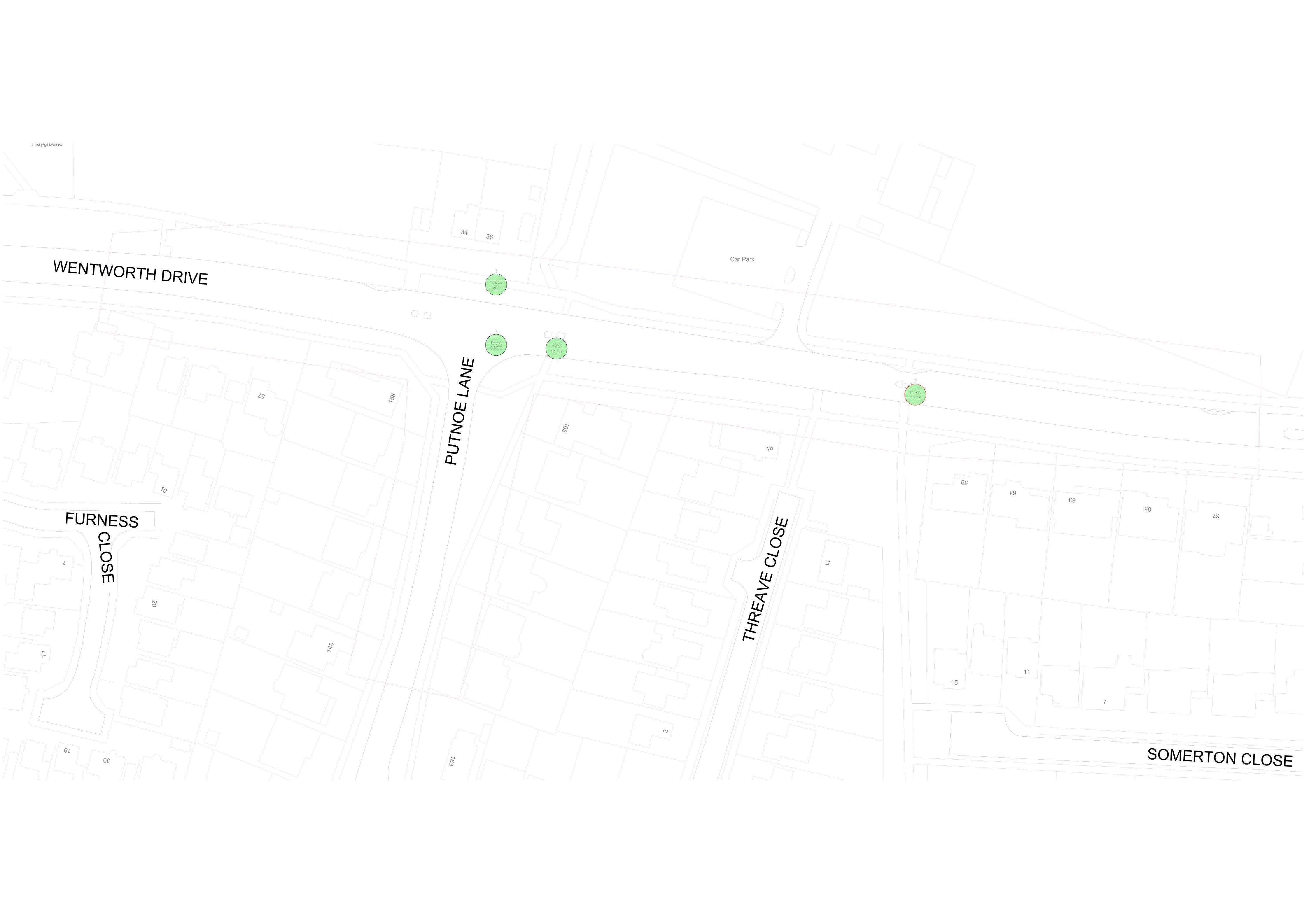
3.3 Junction 2: Wentworth Drive / Putnoe Lane
3.3.1 It is highlighted by the LHA that two of the three accidents which occurred during the
five‐year period involved “rear end shunts “. Details of all accidents at the junction are
summarised below in Table 3.2.
Table 3.2: Accident Summary ‐ J2 Wentworth Drive / Putnoe Lane Reference Severity Location / Direction
of travel Dry / Wet
Description
238382 Slight Outside 36 Wentworth Drive
Dry Vehicle is access driveway at roundabout and collides with cyclist on pavement.
15BA0577 Slight On Roundabout Dry V2 travelling east makes late decision to turn right. V1 travelling west enters roundabout and collides with V2
15BA0013 Slight Wentworth Dr ‐ WB Dry V1 stops at roundabout selects reverse and drives in to V2. Driver of V1 has +ve breath test.
3.3.2 None of the accidents at this junction involved a rear end shunt with all three accidents
happening in very different circumstances. Of the recorded accidents, one involved a
driver who recorded a positive breath test (15BA0013) and reversed into the car behind
them, one involved a resident accessing their private property which is accessed off the
roundabout (238382) and colliding with a cyclist using the shared footway / cycleway.
Only one accident occurred on the carriageway where a vehicle took a late decision to
turn right and a vehicle entering the roundabout collided with the vehicle already on the
carriageway.
3.3.3 As there are no common factors, we would consider that the junction currently operates
in a safe manner and no improvements are necessary.
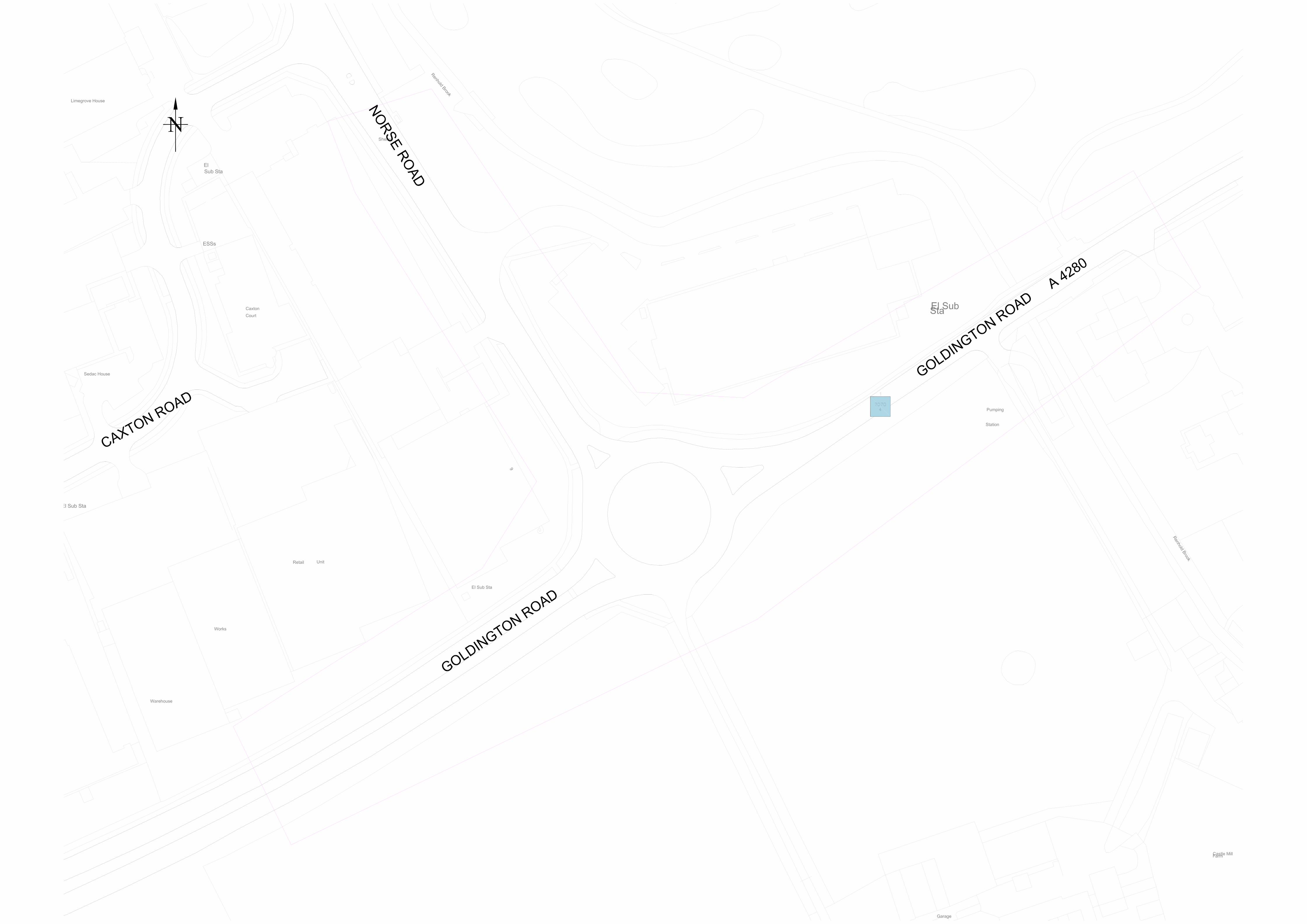
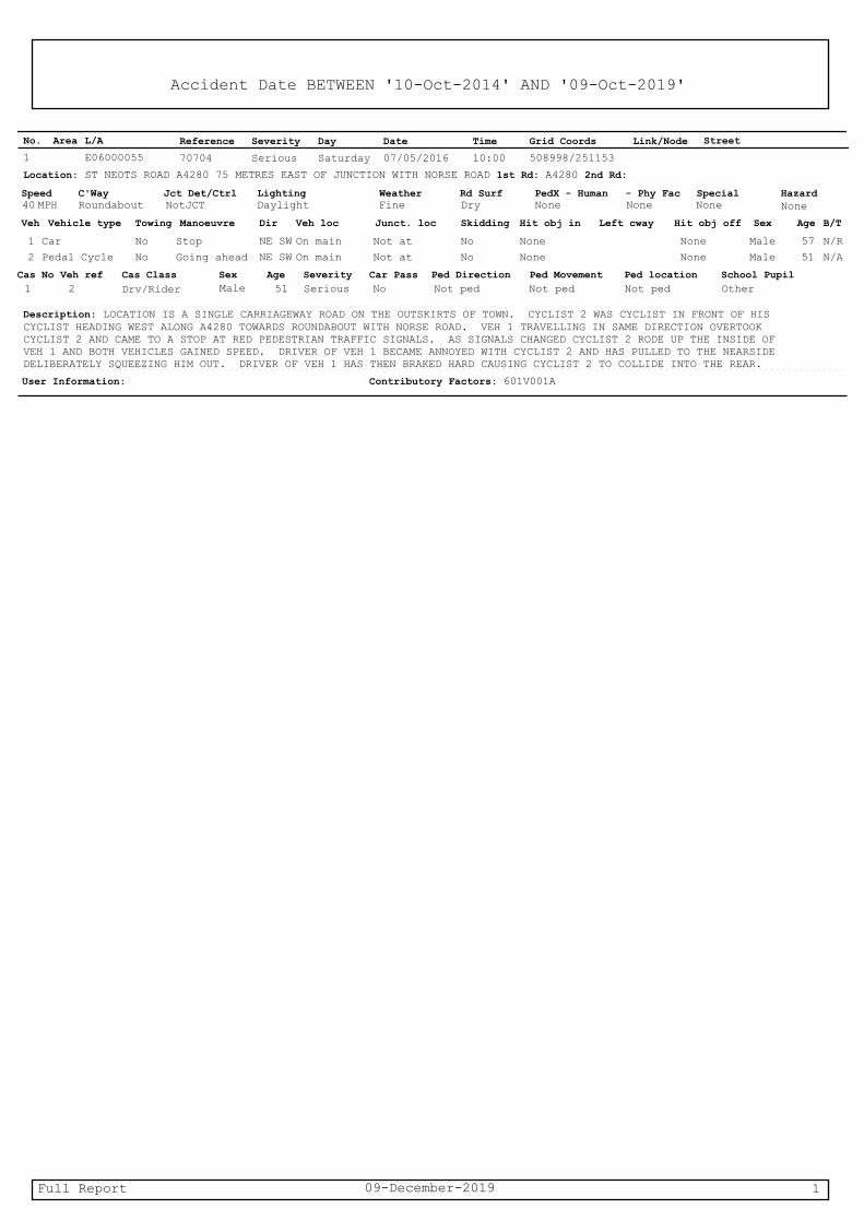
3.4 Junction 3: A4280 St Neots Road / A4280 Goldington Road / Norse
Road
3.4.1 One accident involving a cyclist occurred at this location, hence, the highway authority,
has requested that the cycle network is improved. From the accident data this incident
is described thus:
“Cyclist 2 was cyclist in front of his cyclist [sic] heading west along A4280 towards
roundabout with Norse Road. Veh 1 travelling in same direction overtook Cyclist 2 and
came to a stop at red pedestrian traffic signals. As signals changed Cyclist 2 rode up
the inside of Veh 1 and both vehicles gained speed. Driver of Veh 1 became annoyed
with Cyclist 2 and has pulled to the nearside deliberately squeezing him out. Driver of
Veh 1 has then braked hard causing Cyclist 2 to collide into the rear.“

Transport Assessment Addendum Land off north of Hookhams Lane, Salph End
Martin Andrews Consulting Ltd 4 Revision 0 – June 2020 248‐TA‐02‐0
3.4.2 This accident was caused by driver behaviour and was not because of any deficiencies in
the highway network. It should also be noted that there a shared footway / cycleway on
the north side of the junction and no pedestrian or cyclist provision to the south as there
is not a requirement for any. Therefore, there are no requirements
3.5 Junction 4: A421 / St Neots Road / A4280
3.5.1 As noted by the highway authority three of the five accidents were due to lose of control.
This was noted in the TA which said:
“…three of which involved some form of slight collisions with cars on the opposite
carriageway and a fourth involved a broken‐down vehicle with police in attendance. The
accidents are summarised below in Error! Reference source not found. below. Whist
there are three accidents which result in a broadly similar accident involving a loss of
control in damp conditions and hitting vehicles in the opposite direction, only two are in
the same direction, they are of such a low frequency with enough differences to not form
a pattern.”
3.5.2 The developer will commit to the following survey and improvement works to investigate
any deficiencies with the A4280 arm of the northern roundabout:
Undertaken a survey of the surface including skid resistance to identify any
deficiencies.
If improvements are required to fund provision of a high friction surface topping.
If skid resistance is deemed to be appropriate, the developer will fund a TRO
application to reduce the speed limit.
3.5.3 The cost of any works will be capped at £10,000.
3.6 Junction 5: Ravensden Rd / Oldways Rd / Church End
3.6.1 The highway authority in their response state that the accidents were caused as the
junction has “a low visibility”. The existing visibility has been reviewed, see drawing
enclosed in Appendix G. This shows that visibility splays of 2.4m x 120m can be achieved
which are appropriate for the 40mph speed limit of the road.
3.6.2 The developer will commit to funding speed surveys to determine the actual speed of
vehicles. If speeds are significantly in excess of the 40mph speed limit, then the developer
will fund measures up to the value of £10,000 aimed at reducing vehicle speeds in the
proximity of this junction.

Transport Assessment Addendum Land off north of Hookhams Lane, Salph End
Martin Andrews Consulting Ltd 5 Revision 0 – June 2020 248‐TA‐02‐0
3.7 Summary
3.7.1 A further analysis of the accident data does not highlight any significant existing issues
that would be made significantly worse by the development. However, the following
improvements or actions are proposed:
J1: Hookhams Lane / Norse Road – the development will deliver or provide a
contribution to fund the provision of a shared footway / cycleway around the
entirety of the junction, see Appendix F.
Junction 4: A421 / St Neots Road / A4280 – the development will commit to
funding the following survey and improvement works up to a value of £10,000.
Undertaken a survey of the surface including skid resistance to identify any
deficiencies.
If improvements are required to fund provision of a high friction surface
topping.
If skid resistance is deemed to be appropriate to fund a TRO application to
reduce the speed limit.
Junction 5: Ravensden Rd / Oldways Rd / Church End – the development will
commit to funding the following survey and improvement works up to a value of
£10,000.
The developer will commit to funding speed surveys to determine the actual
speed of vehicles. If speeds are significantly in excess of the 40mph speed
limit then the developer will fund traffic calming measures at reducing
vehicle speeds in the proximity of this junction.

Transport Assessment Addendum Land off north of Hookhams Lane, Salph End
Martin Andrews Consulting Ltd 6 Revision 0 – June 2020 248‐TA‐02‐0
4.0 Traffic Analysis for Junctions
4.1 Introduction
4.1.1 Within the Transport Assessment improvements were proposed to Junctions 2 where the
development has a minimal adverse impact and Junction 3. Relatively minor geometric
improvements were shown to mitigate the impact of the development on both junctions.
4.1.2 The local authority has not raised any objections to the improvements proposed to
junction 3. Considering the highways authority’s comments requesting S106
contributions rather than works, the development will provide a contribution of £15,000
In lieu of highway works at this junction.
4.1.3 The development was also shown to have a small adverse impact on Junction 6, however,
no improvement works are viable as described in full in the Transport Assessment. This
approach has been accepted by the highway authority.
4.2 Junction 2: Wentworth Drive / Putnoe Lane
4.2.1 During the morning peak period the Wentworth Road (W) arm of the junction is operating
over capacity. Without development a maximum RFC value of 0.98 is recorded which is
increased by 0.02 to 1.00 as a result of the development. The proposed development will
also increase vehicle queue length by 3 from 16 to 19. The impact of the development is
small.
4.2.2 The small impact is further highlighted by the assessment which shows that minor
alterations to the white lining would resolve the capacity issues.
4.2.3 It is demonstrated that the impact of the development would be relatively small. As per
the highway authority’s response dated 1 June 2020 the development will contribute of
£5000 to cover the cost of the nil detriment improvements required to offset the impact
of the proposed development.
4.3 Junction 4: A421 / St Neots Road / A4280
4.3.1 The assessment of this junction within the Transport Assessment shows that it operates
within capacity and no improvement works are proposed.

Transport Assessment Addendum Land off north of Hookhams Lane, Salph End
Martin Andrews Consulting Ltd 7 Revision 0 – June 2020 248‐TA‐02‐0
5.0 Access to Local Amenities
5.1 Introduction
5.1.1 A review of the development’s accessibility and existing footway and cycleway provision
was undertaken within the Transport Assessment. Generally, the existing infrastructure
is acceptable for use by new residents of the development.
5.1.2 As part of the review of accessibility revision B of the Transport Assessment made a
commitment to provide the ‘missing’ section of footway on Hookhams Lane to the south
of the site.
5.1.3 However, in their latest response the highway authority is still raising concerns about
accessibility to the facilities listed below:
Village Hall
Pre‐school nursery
Renhold Primary School
Mark Rutherford Secondary School
5.1.4 Each of these is assessed below building on the information provided in pervious versions
of the Transport Assessment.
5.2 Existing footway provision
5.2.1 Salph End and Renhold are characterised by single sided footways which are aften found
in more rural locations. Where single sided footway provision is found it is generally
provided on the south and west of the carriageway thus providing a continuous link.
5.2.2 Footway widths vary but is generally around 1.6m to 1.8m near the site reducing in width
towards Renhold through rural areas before increasing in width in Renhold. Within Salph
End surface quality is generally good and acceptable further afield. The existing provision
is appropriate for use by residents of the new development and would not discourage
use of more sustainable forms of transport.
5.2.3 In areas of higher demand such as to access the local shop, to the secondary school and
towards Bedford the footway provision with improvements is provided on both sides of
the carriageway.

Transport Assessment Addendum Land off north of Hookhams Lane, Salph End
Martin Andrews Consulting Ltd 8 Revision 0 – June 2020 248‐TA‐02‐0
5.3 Village Hall and Renhold Primary School
5.3.1 A plan of the walking route is enclosed in Appendix H. This shows that there is a
continuous footway connection between the development and both the Village Hall and
Renhold Primary School.
5.3.2 The footway provision is generally adequate; however, new and improved crossing points
are to be provided by the development as listed below. The locations of all proposed
improvements are shown on the drawing enclosed in Appendix H.
New uncontrolled crossing to be provided across Hookhams Lane, see also TA11C in
Appendix H.
Tactile paving to be provided to existing Wilden Road crossing near Ravensden Road.
Dropped kerb and tactile paving to be provided to improve Brickfield Road crossing.
Tactile paving to be provided to existing Church End crossing near Wilden Road.
5.3.3 These small improvements will improve accessibility for existing and proposed users. As
the development will provide a school demand to Renhold Primary School will be
relatively low.
5.4 Nursery
5.4.1 An existing private nursery is located to the north of the site. An existing footway is
provided on the opposite side of Ravensden Road which would allow access to the
nursery. To remove the requirement to cross Ravensden Road twice a new footway will
be provided on the south / west side of Ravensden Road to provide a direct access
between the development and the nursery. This new footway is shown on the drawings
enclosed in Appendices H and I.
5.5 Mark Rutherford Secondary School
5.5.1 The secondary school is located to the south of the site off Wentworth Road. Without
improvements there is a continuous footway connection to the school, although this
requires users to cross Hookhams Lane twice. Revision B of the Transport Assessment
committed to filling the gap in footway provision so pedestrians would not need to cross
Hookhams Lane to access the secondary school. This provision would be acceptable and
allow residents of the development to access the secondary school safely.
Transport Assessment Addendum Land off north of Hookhams Lane, Salph End
Martin Andrews Consulting Ltd 9 Revision 0 – June 2020 248‐TA‐02‐0
5.5.2 The highway authority maintains their concerns regarding the footway provision.
Therefore, further improvements are proposed as follows:
Existing footway on Hookhams Lane to the south of the site, see Appendix H, will
be widening removing the carriageway side verge. This will increase the width as
far as is reasonable thus improving the walking environment for existing and
proposed users.
The new footway, also on Hookhams Lane to the south (Appendix H and J), will be
provided with a minimum width of 2.0m as per the previous Transport Assessment.
Where feasible this will be increased to 3m width to allow the existing footway /
cycleway on Hookhams Lane to be extended to the north.
5.6 Summary
5.6.1 The existing network of footways within Salph End is generally appropriate for the users
of the proposed development to access local facilities. There are some areas of the
network which could be approved. The proposed improvements are as follows:
New uncontrolled crossing to be provided across Hookhams Lane, see also TA11C
in Appendix H.
Tactile paving to be provided to existing Wilden Road crossing near Ravensden
Road.
Dropped kerb and tactile paving to be provided to improve Brickfield Road
crossing.
Tactile paving to be provided to existing Church End crossing near Wilden Road.
New footway adjacent to Ravensden Road connecting with the development with
the existing nursey to the north.
Existing footway on Hookhams Lane to the south of the site will be widening
removing the carriageway side verge.
The new footway, also on Hookhams Lane to the south will be provided with a
minimum width of 2.0m as per previous Transport Assessment. Where feasible this
will be increased to 3m width to allow the existing footway / cycleway on Hookhams
Lane to be extended to the north.
Transport Assessment Addendum Land off north of Hookhams Lane, Salph End
Martin Andrews Consulting Ltd 10 Revision 0 – June 2020 248‐TA‐02‐0
6.0 Conclusion
6.1.1 This Transport Assessment Addendum has been prepared in response to the Local
Highway Authority’s dated 1st June 2020. This Addendum should be read in conjunction
with the Transport Assessment.
6.2 Access
6.2.1 As per the Transport Assessment Revision B, the proposed development will provide two
number all movement accesses off Hookhams Lane and Ravensden Road.
6.2.2 A planning application at 27 Hookhams Lane for 14 dwellings, planning reference
18/02496/MAF was recently refused. A new revised planning application, ref
20/00349/MAF, for 13 dwellings was submitted after this planning application for 400
dwellings. Therefore, the adjacent development has no planning status and both
developments need to be considered on their own merits.
6.3 Accident Analysis
6.3.1 A further review of the accident data has not identified any safety concern which will be
made worse by the proposed development. Although the developer will commit to
undertaking or funding the following works / investigations:
J1: Hookhams Lane / Norse Road – the development will deliver or provide a
contribution to fund the provision of a shared footway / cycleway around the
entirety of the junction, see Appendix F.
Junction 4: A421 / St Neots Road / A4280 – the development will commit to
funding the following survey and improvement works up to a value of £10,000.
Undertaken a survey of the surface including skid resistance to identify any
deficiencies.
If improvements are required to fund provision of a high friction surface
topping.
If skid resistance is deemed to be appropriate to fund a TRO application to
reduce the speed limit.
Junction 5: Ravensden Rd / Oldways Rd / Church End – the development will
commit to funding the following survey and improvement works up to a value
of £10,000.
The developer will commit to funding speed surveys to determine the actual
speed of vehicles. If speeds are significantly in excess of the 40mph speed
limit then the developer will fund traffic calming measures at reducing
vehicle speeds in the proximity of this junction.

Transport Assessment Addendum Land off north of Hookhams Lane, Salph End
Martin Andrews Consulting Ltd 11 Revision 0 – June 2020 248‐TA‐02‐0
6.4 Traffic Analysis for Junctions
6.4.1 The adverse impact of the development at all junctions is insignificant. However, nil
determinant improvements have been identified for two junctions. Because of the small
impact only minor geometric improvements are necessary. The developer will undertake
these works or provide a S106 contribution of £20,000 in lieu of works.
6.5 Access to Local Amenities
6.5.1 The existing network of footways within Salph End is generally appropriate for the users
of the proposed development to access local facilities. There are some areas of the
network which could be approved. The proposed improvements are as follows:
New uncontrolled crossing to be provided across Hookhams Lane, see also TA11C
in Appendix H.
Tactile paving to be provided to existing Wilden Road crossing near Ravensden
Road.
Dropped kerb and tactile paving to be provided to improve Brickfield Road
crossing.
Tactile paving to be provided to existing Church End crossing near Wilden Road.
New footway adjacent to Ravensden Road connecting with the development with
the existing nursey to the north.
Existing footway on Hookhams Lane to the south of the site will be widening
removing the carriageway side verge.
The new footway, also on Hookhams Lane to the south will be provided with a
minimum width of 2.0m as per previous Transport Assessment. Where feasible this
will be increased to 3m width to allow the existing footway / cycleway on Hookhams
Lane to be extended to the north.
Transport Assessment Addendum Land off north of Hookhams Lane, Salph End
Martin Andrews Consulting Ltd A Revision 0 – June 2020 248‐TA‐02‐0
Appendix A Highway Authority Objection – 1st June 2020
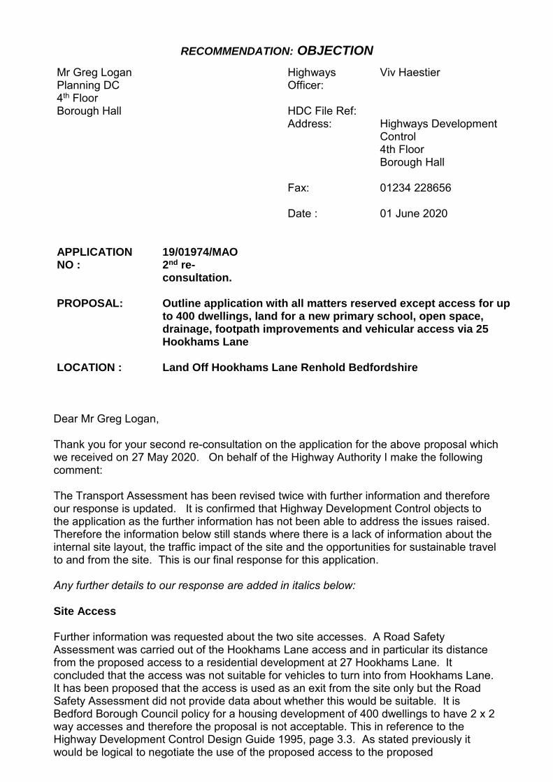
RECOMMENDATION: OBJECTION
Mr Greg Logan Planning DC 4th Floor Borough Hall
Highways Officer:
Viv Haestier
HDC File Ref: Address: Highways Development
Control 4th Floor Borough Hall
Fax: Date :
01234 228656 01 June 2020
APPLICATION NO :
19/01974/MAO 2nd re-consultation.
PROPOSAL: Outline application with all matters reserved except access for up to 400 dwellings, land for a new primary school, open space, drainage, footpath improvements and vehicular access via 25 Hookhams Lane
LOCATION : Land Off Hookhams Lane Renhold Bedfordshire
Dear Mr Greg Logan, Thank you for your second re-consultation on the application for the above proposal which we received on 27 May 2020. On behalf of the Highway Authority I make the following comment: The Transport Assessment has been revised twice with further information and therefore our response is updated. It is confirmed that Highway Development Control objects to the application as the further information has not been able to address the issues raised. Therefore the information below still stands where there is a lack of information about the internal site layout, the traffic impact of the site and the opportunities for sustainable travel to and from the site. This is our final response for this application. Any further details to our response are added in italics below: Site Access Further information was requested about the two site accesses. A Road Safety Assessment was carried out of the Hookhams Lane access and in particular its distance from the proposed access to a residential development at 27 Hookhams Lane. It concluded that the access was not suitable for vehicles to turn into from Hookhams Lane. It has been proposed that the access is used as an exit from the site only but the Road Safety Assessment did not provide data about whether this would be suitable. It is Bedford Borough Council policy for a housing development of 400 dwellings to have 2 x 2 way accesses and therefore the proposal is not acceptable. This in reference to the Highway Development Control Design Guide 1995, page 3.3. As stated previously it would be logical to negotiate the use of the proposed access to the proposed

RECOMMENDATION: OBJECTION
neighbouring development at 27 Hookham’s Lane. Therefore with the above further information Highway Development Control objects to the lack of two suitable accesses to this site. Further information has been provided with a two way access from Hookham’s Lane. In isolation this plan is suitable for a two way access at the planning stage. It is confirmed that the proposed access from Hookham’s Lane at no.27 remains a material consideration. It is also stated that the Hookham’s Lane access would be the primary access to the site, whereas a balance of traffic between the two accesses is needed. Internal Layout Further information was requested as part of the outline application about the internal network of the site. Although it is understood that this is an Outline application, the internal network to include dwellings, internal road and footways and parking is needed to demonstrate that there is sufficient capacity within the site for the proposal. The further information has not provided details of the internal layout and therefore Highway Development Control objects to the lack of information. No further information has been provided about the internal layout. Therefore our response remains the same with an objection to the lack of information. Accident data Further information was provided as requested for the accident history of five junctions near to the site. Although there have been accidents at or near each junction the assessment considers that there is no pattern. For a residential development of this size it is expected that a more detailed assessment of the accident record would be made and any mitigation measures put forward. For example the speed of vehicles and their navigation of the junctions should be assessed. Therefore the further information provided does not provide all of the information needed for a large residential development and therefore Highway Development Control objects to the lack of information. Further information was provided for Junction 1 Hookham’s Lane/Norse Road where there have been three accidents including two cycle accidents but no further measures are considered. At this location we consider that the cycle network needs to be assessed and upgraded. For Junction 2, Wentworth Drive and Putnoe Lane there have been two rear end shunts for vehicles turning right. It is proposed to adjust the white lines at the junction for vehicles turning right into Putnoe Lane but this change is considered to be small and an assessment of the junction is needed. For Junction 3, St Neots Road/Goldington Road/Norse Road there has been one cyclist accident. In this location the cycle network needs to be improved as part of improvements to the junction for capacity, see below. For Junction 4 A421/St Neots Road/A4280 there have been five accidents where three accidents were due to losing control. We consider that this shows that the speed limit and the road surface need to be assessed. There is a footpath around the junction where a shared use cycleway/footpath would assist cyclists at a busy junction.

RECOMMENDATION: OBJECTION
For Junction 5 Ravensden Road / Oldways / Church End there have been three accidents with one severe which involved right hand turns at the junction. No further measures are put forward. We consider that as the junction has a low visibility and therefore the junction needs to be assessed for an increased use. For Junction 6, B660, Oldways, Thurleigh Road there were no recorded accidents. For the capacity of the junction see below. With the further information provided about the accident data it is considered that the response to the accident data for each junction could have considered the evidence and recommended appropriate action. Therefore the Highway Development Control objection due to a lack of information has not changed. Traffic analysis for junctions Further information was provided where a manual traffic count took place on 27/11/2020 for 5 junctions near to the site which are in Appendix L of the Transport Assessment. It was found that 3 of the junctions are currently running at an overcapacity level but it was considered that the development would not have a further impact on these junctions. For a residential development of this size an assessment of the junctions running at overcapacity should be made to analyse the issues and to put forward mitigation measures to improve the junctions. The three junctions running at overcapacity are Wentworth Drive/Putnoe Lane, St Neots Road/Goldington Road/Norse Road and B660/Oldways/Thurleigh. Therefore with the further information provided Highway Development Control objects to the lack of information about how to address the overcapacity issues at the nearby junctions. The most recent further information provides some mitigation for the three junctions which are running at overcapacity. Junction 2, Wentworth Drive/Putnoe Lane, a small change to the white lines at the mini roundabout junction are proposed to adjust the width of the carriageway. It is considered that this would not assist with the overcapacity of the junction or the right hand turn accidents, see above. For the a development of this size which is likely to have a further impact on this junction, to access local facilities in Bedford, an assessment of the junction and appropriate highway safety measures need to be proposed. Junction 4 A421/St Neots Road/A4280 is part of the primary network which has significant overcapacity where new development is likely to cause further traffic delays. Bedford Borough Council considers that the junction needs to be upgraded to accommodate any new development in this area. Therefore the proposal to change the white lines of one lane would not make a significant improvement to this junction. For Junction 6, B660, Oldways, Thurleigh Road, this junction runs at an overcapacity and small measures are proposed but no information is given in the Transport Assessment. The Transport Assessment considers that the junction is too narrow for right hand turn lanes or roundabouts and therefore improvements are limited. The junction has previously had some safety measures installed with the staggered junction to reduce traffic speeds. There is a high capacity of traffic moving from East to West as a key route for traffic from the North of the Borough to Bedford and back. It is observed that as this junction has been previously improved and due to the space at the junction there is limited scope for improvement, especially as the safety measures need to be kept in place.
RECOMMENDATION: OBJECTION
Mitigation to address overcapacity and safety of nearby junctions The further information demonstrates that further measures are needed for the nearby junctions to address overcapacity and safety. For a development for 400 dwellings, Highway Development Control considers that an overall s106 contribution is more suitable for off-site traffic mitigations. This would be for the cost of the minor works to be delivered or as a contribution to any Bedford Borough Council schemes which come forward to address issues at the junctions listed above.
Access to local amenities Further information was requested about access to local amenities and for the developer to assess and put forward sustainable travel measures such as improved footways, the establishment of cycleways to include access on foot or cycle to local amenities and the regular bus network. Here it was previous stated that the regular bus network is at Norse Road and the bus service at Salph End is considered to be infrequent. In particular information was requested about access to local amenities within Renhold and Ravensden, such as the village hall and the pre-school nursery. Information was requested about school travel, such as the catchment for the proposed on site school and how children from outside the development would travel to school. It is also important to have current standard walking and cycling links to Mark Rutherford Secondary School and to Renhold Primary School as not all children within the site would attend the on-site school. Further information was also requested about travel to and from the proposed on site sports facility. The further information received considers that the existing network is sufficient for walking, cycling and bus travel. Where the current provision is for Salph End which is one end of the village of Renhold, it is considered that the infrastructure is not suitable for a new housing development. Therefore Highway Development Control objects to the lack of information with regard to improvements to the walking, cycling and bus network. The most recent further information received proposes a 2m wide footway to fill in the gap in the existing footway on Hookham’s Lane towards Norse Road which is adjacent to the site. This is shown in Appendix X. This does not address the fact the existing footway on Hookham’s Lane is substandard in width and has an uneven surface. The whole footway needs to be upgraded for access to mobility scooters and cycles. Therefore access has not been provided to the frequent buses on Norse Road or to the local amenities in Putnoe. This does provide a suitable pedestrian/cycle link to Mark Rutherford Secondary School where the route is also unlit. The further information suggests that the on-site school would provide provision for pupils from the site or Salph End. As previously stated access by foot/cycle would need to be provided with safe routes to school for the whole of the Renhold parish which has not been shown. It is stated that there is a footway from the site to Renhold Village Hall. There is a gap in the footway network with no footway leading up to the village hall. The available footway is substandard in width and crosses the road with no pedestrian crossing provision. It is also stated that there is a footway to the local nursery which is near to the proposed Ravensden Road access. There is no footway adjacent to the site between the
RECOMMENDATION: OBJECTION
Ravensden Road access and the nursery access which would provide a safe route to the nursery school. There is no further information about the provision of lighting for the pedestrian routes to amenities within Renhold and therefore they are unlikely to be used for travel after dark and in poor visibility. The network of paths in Renhold are narrow and are substandard for increased use by the development. Therefore the Highway Development Control objection to the lack of information about sustainable travel links to schools and local amenities remains. Conclusion Highway Development Control objects to this application where the further information requested did not fulfil the questions raised about the proposed housing development with school and sports pitches. Therefore Highway Development Control objects for the following reasons:
There are not 2 x 2 way accesses required for a 400 dwelling site. There is a lack of information about the internal layout, the accident record and
mitigation, the overcapacity of nearby junctions and their mitigation and access to local amenities and schools via the walking, cycling and bus network.
The most recent information received does not address the points raised as detailed above in italics. Therefore our conclusion of objection to the application remains as above. Reasons for objection 1RG14 LACK OF INFORMATION Insufficient information has been provided by the applicant to enable an accurate assessment to be made of the highway safety/traffic impact implications of the development. The application as submitted is therefore contrary to saved Policy 31 of the Bedford Borough Local Plan 2030. 1RG9 ADDITIONAL ACCESS POINTS The proposed access would increase the number of points at which vehicles enter and leave the public highway. This additional access point would unnecessarily add to the danger and inconvenience inherent in accesses to the highway and would have an adverse effect on road safety and the flow of traffic. The development is therefore contrary to saved Policy 31 of the Bedford Borough Local Plan 2030. Regards Viv Haestier

Transport Assessment Addendum Land off north of Hookhams Lane, Salph End
Martin Andrews Consulting Ltd B Revision 0 – June 2020 248‐TA‐02‐0
Appendix B Hookhams Lane Access
MAC drawing no. 248‐TA11C and
Ravensden Road Access MAC drawing no. 248‐TA12C
6250
2000
3500
Hook
ham
s Lan
e 43m forwardvisibility splay
R40
00
R4000
New uncontrolledcrossing
Notes
1. Based on MSurv 'Topographical Survey' drawing number1215/2272/1.
2. Based on Ordnance Survey mapping.
Visibility Splays - 2.4m x 43m
Forward visibility splay - 43m
Highway boundary
Key
T: 01604 340544 Northampton OfficeE: [email protected] W: mac-ltd.co.uk
Martin Andrews Consulting LtdDrawing No: Revision:
Client: Project:
Title:
Scale:
Size:
Chk:
Drw:
Date:
A3
· Transport Assessments
· Flood Risk Assessments
· Highway Advice
· Access Design
· Drainage Strategies
· Vehicle tracking
Manor Oak Homes Land North of Hookhams Lane, Salph End
No. 25 Hookhams Lane - Access Option 1
248-TA11 C
11/06/20
MJA
MJA
1:500
NORTH
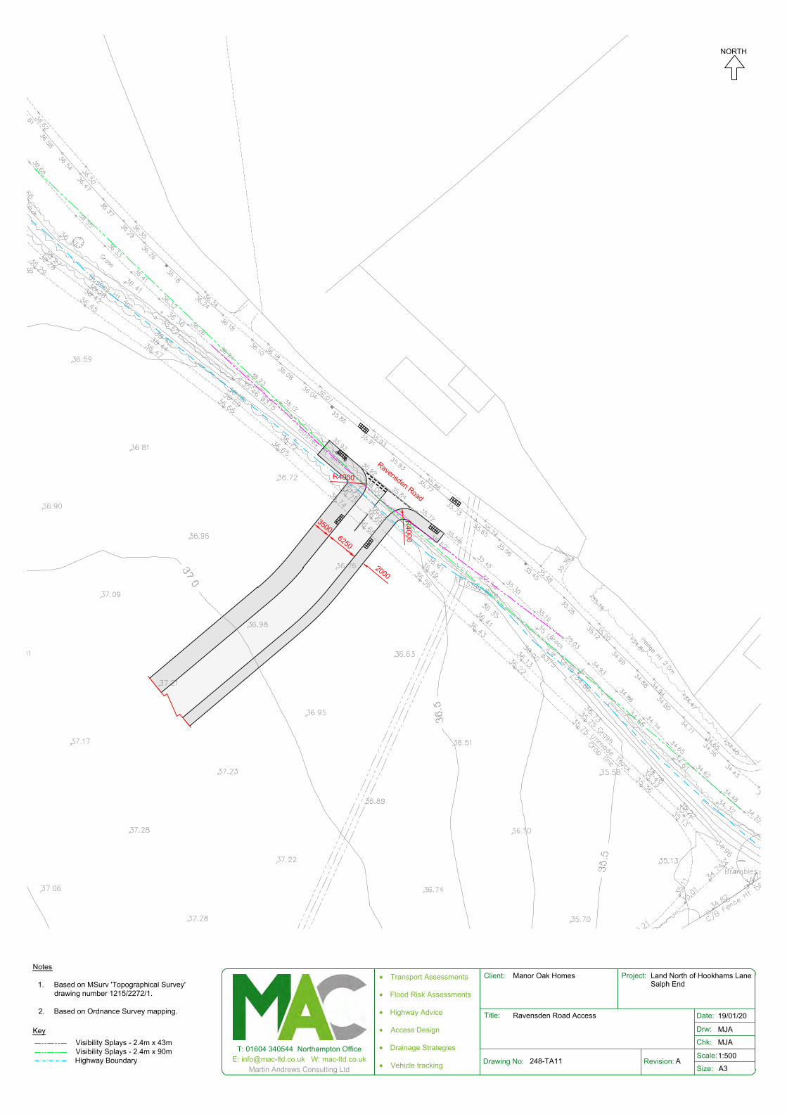
2000
3500
R4000
R4000
Ravensden Road
6250
Notes
1. Based on MSurv 'Topographical Survey'drawing number 1215/2272/1.
2. Based on Ordnance Survey mapping.
Visibility Splays - 2.4m x 43mVisibility Splays - 2.4m x 90mHighway Boundary
Key
T: 01604 340544 Northampton OfficeE: [email protected] W: mac-ltd.co.uk
Martin Andrews Consulting LtdDrawing No: Revision:
Client: Project:
Title:
Scale:
Size:
Chk:
Drw:
Date:
A3
· Transport Assessments
· Flood Risk Assessments
· Highway Advice
· Access Design
· Drainage Strategies
· Vehicle tracking 248-TA11 A
Manor Oak Homes Land North of Hookhams LaneSalph End
Ravensden Road Access 19/01/20
MJA
MJA
1:500
NORTH
Transport Assessment Addendum Land off north of Hookhams Lane, Salph End
Martin Andrews Consulting Ltd C Revision 0 – June 2020 248‐TA‐02‐0
Appendix C Road Safety Audit: Hookhams Lane

Land North of Hookhams Lane, Renhold, Bedford (Drawing No. 248-TA11) Road Safety Audit Stage 1 on behalf of Martin Andrews Consulting Ltd
(Manor Oak Homes) TMS reference no: 15386
Date: 9th December 2019
Unit 1b, Sovereign Court 2,
University of Warwick Science Park,
Sir William Lyons Road, Coventry CV4 7EZ
Tel: +44 (0)24 7669 0900
Fax: +44 (0)24 7669 0274
Email: [email protected]
Web: www.tmsconsultancy.co.uk

Client: Martin Andrews Consulting Ltd (Manor Oak Homes) Scheme: Land North of Hookhams Lane, Renhold, Bedford
Road Safety Audit Stage 1
1
Land North of Hookhams Lane, Renhold Lane, Bedford
Drawing No. 248-TA11
Road Safety Audit Stage 1
1. Introduction 1.1 This report describes a Stage 1 Road Safety Audit carried out on a
proposed priority junction at Land North of Hookhams Lane, Renhold, Bedford, on behalf of Martin Andrews Consulting Ltd (Manor Oak Homes). This audit relates to drawing number 248-TA11. The audit was carried out on 9th December 2019 in the offices of TMS Consultancy.
1.2 The audit team members were as follows:
Audit Team Leader Darren Newbold – MSc, BSc (Hons), MCIHT, MSoRSA Highways England Approved RSA Certificate of Competency Principal Engineer, TMS Consultancy Audit Team Member
Richard Cook - BA (Hons) Graduate Engineer, TMS Consultancy
1.3 The audit comprised an examination of the documents listed in Appendix A.
1.4 The site was visited by the Audit Team on 9th December 2019 at 11.25
am. The weather was fine and dry. Traffic flows were very light. No pedestrian and cycle flows were observed.
1.5 The terms of reference of the Road Safety Audit are as described in
GG 119 (GG 119 superseded HD 19/15 in November 2018). The team has examined and reported only on the road safety implications of the scheme as presented and has not examined or verified the compliance of the design to any other criteria.
1.6 All of the problems described in this report are considered by the audit
team to require action in order to improve the safety of the scheme and minimise collision occurrence.

Client: Martin Andrews Consulting Ltd (Manor Oak Homes) Scheme: Land North of Hookhams Lane, Renhold, Bedford
Road Safety Audit Stage 1
2
1.7 A scheme drawing is included in Appendix B, where the locations of specific problems are referenced. A location plan of the scheme is also included in this Appendix.
1.8 The scheme consists of proposed priority junction access for land at 25
Hookhams Lane, Renhold, Bedford consisting of 400 dwellings and a two-form entry Primary School.
1.9 Road Safety Audit Response Report
Following the completion of the road safety audit, the design team should prepare a road safety audit response report in collaboration with the Overseeing Organisation. The response report should incorporate the following: • Decision Log spreadsheet, where each Problem and
Recommendation in the Safety Audit report is reiterated • In the Decision Log, a response should be provided by the Design
Team and Overseeing Organisation for each problem raised in the RSA report, together with an agreed action
Further information is provided in GG 119 Sections 4.11 to 4.19 and Appendix F (where a road safety audit response report template is available). The response report should be produced and finalised within one month of the issue of the RSA report. A copy of the response report should be issued to the Safety Audit Team for information.

Client: Martin Andrews Consulting Ltd (Manor Oak Homes) Scheme: Land North of Hookhams Lane, Renhold, Bedford
Road Safety Audit Stage 1
3
2. Items resulting from this Stage 1 Audit 2.1 PROBLEM
Location – Hookhams Lane; site access junction
Summary: Potential darkness related vehicle collisions There is no existing street lighting within the vicinity of the proposed site access at No. 25 Hookhams Lane. Given the introduction of the junction and a significant amount of additional traffic (and new turning manoeuvres), the lack of illumination may increase the potential for darkness related vehicle collisions.
RECOMMENDATION
At the detailed design stage, the site access junction should be illuminated.
2.2 PROBLEM
Location – Hookhams Lane
Summary: Potential trip hazard to pedestrians There are shops on the south side of Hookhams Lane within the vicinity of the proposed site access junction, which is likely to introduce a pedestrian desire line to and from the development. Pedestrians wishing to cross Hookhams Lane will have to do so via full height kerbs, which may be a potential trip hazard to pedestrians, particularly to those with visual and mobility impairments.
RECOMMENDATION
At the detailed design stage, an uncontrolled pedestrian crossing point with dropped kerbs and tactile paving should be provided across Hookhams Lane adjacent to the site access junction.
Also, at the detailed design stage, an uncontrolled pedestrian crossing should be provided across the site access road adjacent to the junction with Hookhams Lane.

Client: Martin Andrews Consulting Ltd (Manor Oak Homes) Scheme: Land North of Hookhams Lane, Renhold, Bedford
Road Safety Audit Stage 1
4
2.3 OTHER ISSUE There is an existing BT cover and telegraph pole within the footway that will both be located within the proposed junction area. At the detailed design stage, both the service cover and telegraph poles should be appropriately relocated out of the carriageway into the footway.

Client: Martin Andrews Consulting Ltd (Manor Oak Homes) Scheme: Land North of Hookhams Lane, Renhold, Bedford
Road Safety Audit Stage 1
5
3. Audit Team Statement We certify that the terms of reference of the road safety audit are as
described in GG 119 (formerly HD 19/15).
Audit Team Leader Darren Newbold – MSc, BSc (Hons), MCIHT, MSoRSA Highways England Approved RSA Certificate of Competency Principal Engineer, TMS Consultancy Signed
Date 9th December 2019
Audit Team Member
Richard Cook - BA (Hons) Graduate Engineer, TMS Consultancy Signed
Date 9th December 2019
TMS Consultancy Unit 1b, Sovereign Court 2, University of Warwick Science Park Sir William Lyons Road Coventry, CV4 7EZ + 44 (0)24 7669 0900
[email protected] www.tmsconsultancy.co.uk

Client: Martin Andrews Consulting Ltd (Manor Oak Homes) Scheme: Land North of Hookhams Lane, Renhold, Bedford
Road Safety Audit Stage 1 Appendix A
Appendix A Documents Examined:
248-TA13-Hookhams Access--Both Accesses.pdf Salph End ACCIDENT PLAN.pdf Salph End ACCIDENT REPORTS.pdf 18+02496+MAF+V13-Transport Statement.pdf 18+02496+MAF+V26..pdf 18+02496+MAF+V26A..pdf 18+02496+MAF+V27..pdf 248-TA-01-0-Salph End.pdf 248-TA01A-Location Plan.pdf 248-TA11A-No. 25 Hookhams Lane Access Option 1.pdf
Other Information Provided:
RSA1 - Checklist of Information Required.docx

Client: Martin Andrews Consulting Ltd (Manor Oak Homes) Scheme: Land North of Hookhams Lane, Renhold, Bedford
Road Safety Audit Stage 1 Appendix B
Appendix B
Please refer to the following page for a plan illustrating the locations of the problems identified as part of this audit (location numbers refer to paragraph
numbers in the report).
The location of the scheme is shown below:
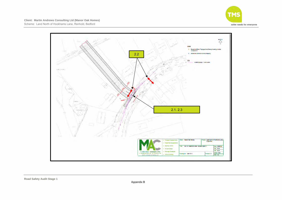
Client: Martin Andrews Consulting Ltd (Manor Oak Homes) Scheme: Land North of Hookhams Lane, Renhold, Bedford
Road Safety Audit Stage 1 Appendix B
2.2
2.1. 2.3

Transport Assessment Addendum Land off north of Hookhams Lane, Salph End
Martin Andrews Consulting Ltd D Revision 0 – June 2020 248‐TA‐02‐0
Appendix D MAC Transport Assessment (Rev B): Accident Data Review

Transport Assessment Land north of Hookhams Ln, Salph End
Martin Andrews Consulting Ltd 7 Revision B – March 2020 248‐TA‐01‐B
3.4 Accident Data
3.4.1 Accident data has been obtained from the local highway authority. The first issue of the
Transport Assessment included an accident search comprising Ravensden Road,
Hookhams Lane and the Norse Road roundabout. This data covered the most recent 5
year period available at the time from 19 May 2014 to 18 May 2019‐. A copy of the
accident data is enclosed in Appendix F.
3.4.2 This showed that there had been no accidents on Hookhams Lane or Ravensden Road
during this 5 year period.
3.4.3 At Junction 1 Hookhams Lane / Norse Road roundabout there have been two recorded
slight accidents and one serious accident. The accidents are summarised below in Table
3.5 below. A review of the basic facts shows that all three accidents occurred in different
locations and under different circumstances. There are not any common causes for the
accidents.
Table 3.5: Accident Summary ‐ J1 Hookhams Lane / Norse Road Reference Severity Location / Direction
of travel Dry / Wet
Description
313804 Slight Hookhams Ln ‐ NB Dry Cyclist crossed between SB queuing traffic and was obscured by van. Vehicle travelling NB collides with cyclist.
67374 Slight On Roundabout near Norse Road
Dry Vehicle pulls out and collides with cyclist on roundabout.
112248 Serious Norse Road ‐ WB Dry Car left carriageway no other vehicles involved. Tiredness / Illness listed as contributory factor
3.4.4 Accident data for the remaining junctions was obtained at a later date at the request of
Bedford Borough Council. This accident data covers the period 10 October 2014 to 9
October 2019.
3.4.5 At Junction 2 Wentworth Drive / Putnoe Lane there have been three recorded slight
accidents. One slight accident occurred on Wentworth Road east arm with two accidents
recorded on the circulatory carriageway. The accidents are summarised below in Table
3.6 below. A review of the basic facts shows that all three accidents occurred in different
locations and under different circumstances. There are not any common causes for the
accidents.
Table 3.6: Accident Summary ‐ J2 Wentworth Drive / Putnoe Lane Reference Severity Location / Direction
of travel Dry / Wet
Description
238382 Slight Outside 36 Wentworth Drive
Dry Vehicle is access driveway at roundabout and collides with cyclist on pavement.
15BA0577 Slight On Roundabout Dry V2 travelling east makes late decision to turn right. V1 travelling west enters roundabout and collides with V2

Transport Assessment Land north of Hookhams Ln, Salph End
Martin Andrews Consulting Ltd 8 Revision B – March 2020 248‐TA‐01‐B
15BA0013 Slight Wentworth Dr ‐ WB Dry V1 stops at roundabout selects reverse and drives in to V2. Driver of V2 has +ve breath test.
3.4.6 At Junction 3 A4280 St Neots Road / A4280 Goldington Road / Norse Road there have
been no recorded accidents. On the Goldington Road approach there has been a single
accident. The accident is summarised below in Table 3.7 below. As there is only a single
accident there are an no common causes to review.
Table 3.7: Accident Summary ‐ J3 A4280 St Neots Rd / A4280 Goldington Rd / Norse Rd Reference Severity Location / Direction
of travel Dry / Wet
Description
70704 Serious St Neots Rd, 75m east of junction WB
Dry Aggressive driving by car causes crash with cyclist.
3.4.7 At Junction 4 A421 / St Neots Road / A4280 northern roundabout there are five recorded
slight injury accidents. Four of which have occurred on the A4280 arm, three of which
involved some form of slight collisions with cars on the opposite carriageway and a fourth
involved a broken‐down vehicle with police in attendance. The accidents are summarised
below in Table 3.8 below. Whist there are three accidents which result in a broadly similar
accident involving a loss of control in damp conditions and hitting vehicles in the opposite
direction, only two are in the same direction, they are of such a low frequency with
enough differences to not form a pattern.
Table 3.8: Accident Summary ‐ J4 A421 / St Neots Road / A4280 northern roundabout Reference Severity Location / Direction
of travel Dry / Wet
Description
14BA1259 Slight A4280 St Neots Rd NW
Wet V2 sees police car about to enter roundabout on an emergency call and brakes. V1 collides into rear of V2.
235061 Slight A4280 St Neots Rd ‐ SW
Wet V1 lost control in damp conditions and collided with V2 travelling in opposite direction. Contributory factors – swerved and aggressive driving V1
337716 Slight A4280 St Neots Rd ‐ SW
Wet V2 exiting roundabout collides with V1 on opposite side of the carriageway
802367 Slight A4280 St Neots Rd ‐ NE
Wet V4 police car had stopped on side of road, helping a broken down vehicle. V3 slowed on opposite side of carriage way after seeing blue lights but did not notice v2 had pulled over and stopped. V3 collided with v2, pushing it into the rear of v1.
80273 Slight A4280 St Neots Rd ‐ NE
Wet V1 loses control has possibly mis‐judged the carriageway and junction and has then collided with the V2 travelling in opposite direction.
Transport Assessment Land north of Hookhams Ln, Salph End
Martin Andrews Consulting Ltd 9 Revision B – March 2020 248‐TA‐01‐B
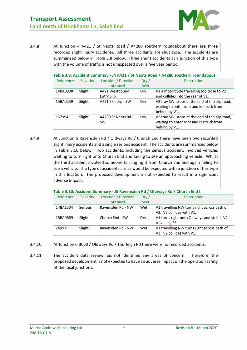
3.4.8 At Junction 4 A421 / St Neots Road / A4280 southern roundabout there are three
recorded slight injury accidents. All three accidents are shut type. The accidents are
summarised below in Table 3.8 below. Three shunt accidents at a junction of this type
with the volume of traffic is not unexpected over a five year period.
Table 3.9: Accident Summary ‐ J4 A421 / St Neots Road / A4280 southern roundabout Reference Severity Location / Direction
of travel Dry / Wet
Description
14BA0998 Slight A421 Westbound Entry Slip
Dry V1 a motorcycle travelling too close to V2 and collides into the rear of V1.
15BA0259 Slight A421 Exit slip ‐ SW Dry V2 trav SW, stops at the end of the slip road, waiting to enter rdbt and is struck from behind by V1.
167994 Slight A4280 St Neots Rd ‐ SW
Dry V2 trav SW, stops at the end of the slip road, waiting to enter rdbt and is struck from behind by V1.
3.4.9 At Junction 5 Ravensden Rd / Oldways Rd / Church End there have been two recorded
slight injury accidents and a single serious accident. The accidents are summarised below
in Table 3.10 below. Two accidents, including the serious accident, involved vehicles
waiting to turn right onto Church End and failing to see an approaching vehicle. Whilst
the third accident involved someone turning right from Church End and again failing to
see a vehicle. The type of accidents are as would be expected with a junction of this type
in this location. The proposed development is not expected to result in a significant
adverse impact.
Table 3.10: Accident Summary ‐ J5 Ravensden Rd / Oldways Rd / Church End t Reference Severity Location / Direction
of travel Dry / Wet
Description
14BA1304 Serious Ravensden Rd ‐ NW Wet V1 travelling NW turns right across path of V2. V2 collides with V1.
15BA0669 Slight Church End ‐ SW Dry V1 turns right onto Oldways and strikes V2 travelling SE.
249935 Slight Ravensden Rd ‐ NW Wet V1 travelling NW turns right across path of V2. V2 collides with V1.
3.4.10 At Junction 6 B660 / Oldways Rd / Thurleigh Rd there were no recorded accidents.
3.4.11 The accident data review has not identified any areas of concern. Therefore, the
proposed development is not expected to have an adverse impact on the operation safety
of the local junctions.
Transport Assessment Addendum Land off north of Hookhams Lane, Salph End
Martin Andrews Consulting Ltd E Revision 0 – June 2020 248‐TA‐02‐0
Appendix E Full Accident Data


Accident Date BETWEEN '19-May-2014' AND '18-May-2019'
Reference Severity Date Time Grid CoordsArea DayL/A Link/Node StreetNo.
Serious112248 13/09/2016 507760/25208023:08E06000055
Location: NORSE ROAD UNSPECIFIED ROAD OR LOCATION 10 METRES SOUTH OF JUNCTION WITH CHURCH LANE C40 1st Rd: U0 2nd Rd: C40
Tuesday 1
SpeedMPH
C'WayRoundabout
Jct Det/CtrlR'dabt Give
LightingDark/lights lit
WeatherFine
Rd SurfDry
PedX - HumanNone
- Phy FacRefuge
SpecialNone
Hazard
None 30
Veh Vehicle type Manoeuvre Veh loc Junct. locTowing Skidding Hit obj in Left cway Hit obj off Sex AgeDir B/T
1 Lt hand bendCar FemaleNo NoJunt appr OffsideNone TreeOn main 70SE NW N/R
Cas No Veh ref Cas Class AgeSex Severity Ped Direction Ped Movement Ped locationCar Pass School Pupil
1 70 1 SeriousDrv/Rider Female Not pedNot ped Not pedNo Other
2 76 1 SlightPassenger Male Not pedNot ped Not pedFront OtherDescription: V1 has been travelling along Norse Road heading towards roundabout on Church Lane. V1 has left the carriageway into a small woodland area, where it has collided with a tree.
User Information: Contributory Factors: 503V001B 505V001B
Slight14BA0537 11/06/2014 507560/25223709:50E06000055
Location: Uc Wentworth Drive Metres Uc Dover Crescent, Bedford, Bedfordshire 1st Rd: U 2nd Rd: U
Wednesday 2
SpeedMPH
C'WayRoundabout
Jct Det/CtrlMini-R Give
LightingDaylight
WeatherFine
Rd SurfDry
PedX - HumanNone
- Phy FacNone
SpecialNone
Hazard
None 30
Veh Vehicle type Manoeuvre Veh loc Junct. locTowing Skidding Hit obj in Left cway Hit obj off Sex AgeDir B/T
1 Right turnBus or Coach MaleNo NoMid junction None NoneOn main 51S E -ve
2 Going aheadCar FemaleNo NoMid junction None NoneOn main 37E W -ve
Cas No Veh ref Cas Class AgeSex Severity Ped Direction Ped Movement Ped locationCar Pass School Pupil
1 37 2 SlightDrv/Rider Female Not pedNot ped Not pedNo Other
Description: V2 Trav West onto Rdbt. V1 a Bus, Trav North, turning right at Rdbt, Fails to Give Way to V2 and Collision Occurs.
User Information: Contributory Factors: 405V001A
Slight313804 29/06/2018 507721/25217808:08E06000055
Location: HOOKHAMS LANE 1st Rd: U 2nd Rd:
Friday 3
SpeedMPH
C'WaySingle c'way
Jct Det/CtrlNotJCT
LightingDaylight
WeatherFine
Rd SurfDry
PedX - HumanNone
- Phy FacNone
SpecialNone
Hazard
None 30
Veh Vehicle type Manoeuvre Veh loc Junct. locTowing Skidding Hit obj in Left cway Hit obj off Sex AgeDir B/T
1 Going aheadCar FemaleNo NoNot at None NoneOn main 26S N N/R
2 StartPedal Cycle MaleNo NoNot at None NoneOn main 12E W N/A
Cas No Veh ref Cas Class AgeSex Severity Ped Direction Ped Movement Ped locationCar Pass School Pupil
1 12 2 SlightDrv/Rider Male Not pedNot ped Not pedNo Other
Description: V1 was entering Hookhams Lane from the roundabout. On the other side of the road was a queue of traffic where a pedestrian crossing over the road has been covered by a white van. As V1 has been driving down Hookhams Lane, a 12 year old male on a bicycle (V2) has come out from behind the van into the road. Driver of V1 has a short period of time to react managing to brake but has collided with the male causing him to fall off his bicycle hitting his head, knee and ankle.
User Information: Contributory Factors: 801C001A 802C001B
Slight67374 02/05/2016 507746/25209609:15E06000055
Location: NORSE ROAD UNSPECIFIED ROAD OR LOCATION CHURCH LANE C40 1st Rd: U0 2nd Rd: C40
Monday 4
SpeedMPH
C'WayRoundabout
Jct Det/CtrlR'dabt Give
LightingDaylight
WeatherFine
Rd SurfDry
PedX - HumanNone
- Phy FacRefuge
SpecialNone
Hazard
None 30
Veh Vehicle type Manoeuvre Veh loc Junct. locTowing Skidding Hit obj in Left cway Hit obj off Sex AgeDir B/T
1 Going aheadCar MaleNo NoLeave r'about None NoneOn main 81NW SE -ve
2 Going aheadPedal Cycle MaleNo NoMid junction None NoneOn main 37N S N/A
Cas No Veh ref Cas Class AgeSex Severity Ped Direction Ped Movement Ped locationCar Pass School Pupil
1 37 2 SlightDrv/Rider Male Not pedNot ped Not pedNo Other
Description: V2 was travelling southbound from Hook Lane Renhold to Church Lane round the roundabout. V1 was travelling eastbound from Wentworth Drive to Norse Road. V2 was coming past the Norse Road junction, as v1 attempted to pull off the roundabout v1 pulled directly into v2's path causing him to fall off into the road.
User Information: Contributory Factors: 405V001A 403V001A 505V001B
18-July-2019 1Full Report
Accident Date BETWEEN '10-Oct-2014' AND '09-Oct-2019'
Reference Severity Date Time Grid CoordsArea DayL/A Link/Node StreetNo.
Slight15BA0013 10/01/2015 506862/25233117:13E06000055
Location: Uc Wentworth Drive 10 Metres East of Uc Putnoe Lane, Bedford, Bedfordshire 1st Rd: U 2nd Rd: U
Saturday 1
SpeedMPH
C'WaySingle c'way
Jct Det/CtrlR'dabt Give
LightingDark/lights lit
WeatherFine Wind
Rd SurfDry
PedX - HumanNone
- Phy FacRefuge
SpecialNone
Hazard
None 30
Veh Vehicle type Manoeuvre Veh loc Junct. locTowing Skidding Hit obj in Left cway Hit obj off Sex AgeDir B/T
1 ReversingCar MaleNo NoJunt appr None NoneOn main 39W E +ve
2 WaitingCar MaleNo NoJunt appr None NoneOn main 20E W -ve
Cas No Veh ref Cas Class AgeSex Severity Ped Direction Ped Movement Ped locationCar Pass School Pupil
1 39 1 SlightDrv/Rider Male Not pedNot ped Not pedNo Other
Description: V1 Trav in Front of V2 on Trav West on Approach to Rdbt. V2 Hangs Back Owing to Erratic Driving by V1. V1 Stops at Rdbt and then Selects Reverse and Collides into Front of V2. V1 Drives off Failing to Stop. Apprehended Shortly After.
User Information: Contributory Factors: 501V001A 601V001A
Slight15BA0576 22/06/2015 506963/25231815:04E06000055
Location: Unclassified Road WENTWORTH DRIVE at SOMERTON WALK, BEDFORD, Bedfordshire 1st Rd: U 2nd Rd:
Monday 2
SpeedMPH
C'WaySingle c'way
Jct Det/CtrlNotJCT
LightingDaylight
WeatherFine
Rd SurfDry
PedX - HumanNone
- Phy FacRefuge
SpecialNone
Hazard
None 30
Veh Vehicle type Manoeuvre Veh loc Junct. locTowing Skidding Hit obj in Left cway Hit obj off Sex AgeDir B/T
1 Going aheadCar MaleNo NoNot at None NoneOn main 43E W -ve
Cas No Veh ref Cas Class AgeSex Severity Ped Direction Ped Movement Ped locationCar Pass School Pupil
1 14 1 SlightPedestrian Female Ped x'ingSouth OffsideNo Yes
Description: CAS1 A PED CROSSES ROAD AT CENTRAL REFUGE. CAS1 IS ALLOWED TO CROSS BY SLOWING VEHICLE ON EAST CARRIAGEWAY BUT CAS1 FAILS TO CHECK WESTBOUND SIDE, STEPS INTO ROAD AND IS STRUCK BY V1 TRAV WEST.
User Information: Contributory Factors: 802C001A
Slight15BA0577 23/06/2015 506845/25233214:10E06000055
Location: Unclassified Road WENTWORTH DRIVE, at its Junction with Unclassified Road PUTNOE LANE, BEDFORD, Bedfordshire 1st Rd: U 2nd Rd: U
Tuesday 3
SpeedMPH
C'WayRoundabout
Jct Det/CtrlMini-R Give
LightingDaylight
WeatherFine
Rd SurfDry
PedX - HumanNone
- Phy FacRefuge
SpecialNone
Hazard
None 30
Veh Vehicle type Manoeuvre Veh loc Junct. locTowing Skidding Hit obj in Left cway Hit obj off Sex AgeDir B/T
1 Going aheadCar FemaleNo NoMid junction None NoneOn main 78E W -ve
2 Right turnCar FemaleNo NoMid junction None NoneOn main 74W S -ve
Cas No Veh ref Cas Class AgeSex Severity Ped Direction Ped Movement Ped locationCar Pass School Pupil
1 78 1 SlightDrv/Rider Female Not pedNot ped Not pedNo Other
2 74 2 SlightDrv/Rider Female Not pedNot ped Not pedNo OtherDescription: V2 TRAV EAST, MAKES A LATE DECISION TO TURN RIGHT AT RDBT JUNC. V1 TRAV WEST, ENTERS RDBT AND COLLIDES WITH V2.
User Information: Contributory Factors: 406V001A 403V002A
Slight238382 26/09/2017 506845/25234916:20E06000055
Location: OUTSIDE NO 36 WENTWORTH DRIVE AT JN WITH PUTNOE LANE 1st Rd: U 2nd Rd: U
Tuesday 4
SpeedMPH
C'WayRoundabout
Jct Det/CtrlMini-R Give
LightingDaylight
WeatherFine
Rd SurfDry
PedX - HumanNone
- Phy FacRefuge
SpecialNone
Hazard
None 30
Veh Vehicle type Manoeuvre Veh loc Junct. locTowing Skidding Hit obj in Left cway Hit obj off Sex AgeDir B/T
1 Going aheadCar MaleNo NoLeave r'about None NoneCycleway 69S N -ve
2 Going aheadPedal Cycle MaleNo NoJunt appr None NoneCycleway 15E W N/A
Cas No Veh ref Cas Class AgeSex Severity Ped Direction Ped Movement Ped locationCar Pass School Pupil
1 15 2 SlightDrv/Rider Male Not pedNot ped Not pedNo Other
Description: V001 WAS TRAVELLING ALONG PUTNOE LANE TOWARDS ROUNDABOUT WITH WENTWORTH DRIVE. V001'S DRIVEWAY IS IMMEDIATELY OFF THE ROUNDABOUT BETWEEN 1ST AND 3RD EXIT. V002 WAS CYCLING ALONG HE PAVEMENT. V001 ENTERED ROUNDABOUT AND SAW A VEHICLE TO HIS NEARSIDE COMING ONTO ROUNDABOUT AS HE SLOWED TO ENTER HIS DRIVEWAY AND COLLIDED WITH A CYCLIST (V002) AS HE DROVE ONTO HIS DRIVEWAY
User Information: Contributory Factors: 108V001A
09-December-2019 1Full Report
Accident Date BETWEEN '10-Oct-2014' AND '09-Oct-2019'
Reference Severity Date Time Grid CoordsArea DayL/A Link/Node StreetNo.
Serious70704 07/05/2016 508998/25115310:00E06000055
Location: ST NEOTS ROAD A4280 75 METRES EAST OF JUNCTION WITH NORSE ROAD 1st Rd: A4280 2nd Rd:
Saturday 1
SpeedMPH
C'WayRoundabout
Jct Det/CtrlNotJCT
LightingDaylight
WeatherFine
Rd SurfDry
PedX - HumanNone
- Phy FacNone
SpecialNone
Hazard
None 40
Veh Vehicle type Manoeuvre Veh loc Junct. locTowing Skidding Hit obj in Left cway Hit obj off Sex AgeDir B/T
1 StopCar MaleNo NoNot at None NoneOn main 57NE SW N/R
2 Going aheadPedal Cycle MaleNo NoNot at None NoneOn main 51NE SW N/A
Cas No Veh ref Cas Class AgeSex Severity Ped Direction Ped Movement Ped locationCar Pass School Pupil
1 51 2 SeriousDrv/Rider Male Not pedNot ped Not pedNo Other
Description: LOCATION IS A SINGLE CARRIAGEWAY ROAD ON THE OUTSKIRTS OF TOWN. CYCLIST 2 WAS CYCLIST IN FRONT OF HIS CYCLIST HEADING WEST ALONG A4280 TOWARDS ROUNDABOUT WITH NORSE ROAD. VEH 1 TRAVELLING IN SAME DIRECTION OVERTOOK CYCLIST 2 AND CAME TO A STOP AT RED PEDESTRIAN TRAFFIC SIGNALS. AS SIGNALS CHANGED CYCLIST 2 RODE UP THE INSIDE OF VEH 1 AND BOTH VEHICLES GAINED SPEED. DRIVER OF VEH 1 BECAME ANNOYED WITH CYCLIST 2 AND HAS PULLED TO THE NEARSIDE DELIBERATELY SQUEEZING HIM OUT. DRIVER OF VEH 1 HAS THEN BRAKED HARD CAUSING CYCLIST 2 TO COLLIDE INTO THE REAR.
User Information: Contributory Factors: 601V001A
09-December-2019 1Full Report


Accident Date BETWEEN '10-Oct-2014' AND '09-Oct-2019'
Reference Severity Date Time Grid CoordsArea DayL/A Link/Node StreetNo.
Slight148127 07/01/2017 510330/25141823:47E06000055
Location: MARKER POST 246 BYPASS A421 1st Rd: A421 2nd Rd:
Saturday 1
SpeedMPH
C'WayRoundabout
Jct Det/CtrlNotJCT
LightingDark/no lights
WeatherFine
Rd SurfDry
PedX - HumanNone
- Phy FacNone
SpecialNone
Hazard
P/Acc 70
Veh Vehicle type Manoeuvre Veh loc Junct. locTowing Skidding Hit obj in Left cway Hit obj off Sex AgeDir B/T
1 Going aheadCar MaleNo NoNot at O/s reboundNone Cent barrOn main 49E W N/C
2 Going aheadCar MaleNo NoNot at O/s reboundPrev acc Cent barrOn main 30E W -ve
Cas No Veh ref Cas Class AgeSex Severity Ped Direction Ped Movement Ped locationCar Pass School Pupil
1 30 2 SlightDrv/Rider Male Not pedNot ped Not pedNo Other
Description: V1 HAD BEEN TRAVELLING WESTBOUND ALONG THE A421, WHEN IT COLLIDED HEAVILY WITH THE CENTRAL RESERVATION BARRIER, CAUSING EXTENSIVE DAMAGE TO X17 UPRIGHT POSTS AND TO THE VEHICLE ITSELF. AS A RESULT OF THIS COLLISION, V1 CAME TO A STOP IN LANE 1, AND HAD NO HAZARD OR MAIN LIGHTS ILLUMINATED. V2 HAD ALSO BEEN TRAVELLING WESTBOUND ALONG THE A421, AND HAD TO SWERVE OUT OF THE WAY TO AVOID A DIRECT COLLISION, WITH V1, AS IT SAW IT AT THE LAST MINUTE, DUE TO NO LIGHTS BEING ILLUMINATED. AS A RESULT, V2 ALSO COLLIDED WITH THE CENTRAL RESERVATION BARRIER, BEFORE COMING TO A STOP IN LANE 1. DAMAGE TO X5 MORE UPRIGHTS HAD BEEN CAUSED BY V2.
User Information: Contributory Factors:
Slight14BA0998 27/10/2014 510624/25156018:06E06000055
Location: A4280 St Neots Road Metres A421 Westbound Entry Slip, Renhold, Bedfordshire 1st Rd: A4280 2nd Rd: A421
Monday 2
SpeedMPH
C'WayRoundabout
Jct Det/CtrlR'dabt Give
LightingDark/lights lit
WeatherFine
Rd SurfDry
PedX - HumanNone
- Phy FacNone
SpecialNone
Hazard
None 60
Veh Vehicle type Manoeuvre Veh loc Junct. locTowing Skidding Hit obj in Left cway Hit obj off Sex AgeDir B/T
1 Right turnM/cycle 50 - 125cc MaleNo NoMid junction None NoneOn main 32NW SW -ve
2 Right turnCar FemaleNo NoMid junction None NoneOn main 23NW SW -ve
Cas No Veh ref Cas Class AgeSex Severity Ped Direction Ped Movement Ped locationCar Pass School Pupil
1 32 1 SlightDrv/Rider Male Not pedNot ped Not pedNo Other
Description: V1 a Motor Cycle Trav Behind V2 onto Rdbt. V2 Starts to Turn right and V1 Following Too Close Collides into Rear of V2. Rider of V1 Falls Off.
User Information: Contributory Factors: 403V001B 403V002B
Slight14BA1259 27/12/2014 510504/25162016:53E06000055
Location: A428 Saint Neots Road Metres A421 Bedford Bypass, Renhold, Bedfordshire 1st Rd: A428 2nd Rd: A421
Saturday 3
SpeedMPH
C'WayRoundabout
Jct Det/CtrlR'dabt Give
LightingDark/lights lit
WeatherRain Wind
Rd SurfWet
PedX - HumanNone
- Phy FacNone
SpecialNone
Hazard
None 60
Veh Vehicle type Manoeuvre Veh loc Junct. locTowing Skidding Hit obj in Left cway Hit obj off Sex AgeDir B/T
1 StopCar MaleNo YesEnt r'about None NoneOn main 48SE SW -ve
2 StopCar MaleNo NoEnt r'about None NoneOn main 32SE SW -ve
3 Left turnCar MaleNo NoEnt r'about None NoneOn main 29SW NW -ve
Cas No Veh ref Cas Class AgeSex Severity Ped Direction Ped Movement Ped locationCar Pass School Pupil
1 32 2 SlightDrv/Rider Male Not pedNot ped Not pedNo Other
Description: V2 Trav Nw, Enters Rdbt, Followed by V1. V2 Driver Sees V3, a Marked Police Vehicle on Blue Lights and Sirens About to Enter Rdbt from N/S Slip Road. V2 Brakes and is Hit from Behind by V1. V3 Unaware Continues On.
User Information: Contributory Factors: 103V001A 408V002B 307V001B
Slight14BA1291 08/12/2014 510298/25145208:15E06000055
Location: A4280 Saint Neots Road 250 Metres West of Water End, Renhold, Bedfordshire 1st Rd: A4280 2nd Rd:
Monday 4
SpeedMPH
C'WaySingle c'way
Jct Det/CtrlNotJCT
LightingDaylight
WeatherFine
Rd SurfWet
PedX - HumanNone
- Phy FacNone
SpecialNone
Hazard
None 60
Veh Vehicle type Manoeuvre Veh loc Junct. locTowing Skidding Hit obj in Left cway Hit obj off Sex AgeDir B/T
1 StopCar MaleNo YesNot at None NoneOn main 25SW NE -ve
2 StopCar FemaleNo NoNot at None NoneOn main 37SW NE -ve
Cas No Veh ref Cas Class AgeSex Severity Ped Direction Ped Movement Ped locationCar Pass School Pupil
1 37 2 SlightDrv/Rider Female Not pedNot ped Not pedNo Other
2 8 2 SlightPassenger Female Not pedNot ped Not pedFront OtherDescription: V2 Trav Ne, Begins to Slow Gently on Approach to Rdbt Junc Ahead. V1 Trav Behind Witnessed Trav Too Fast for Conditions, Brakes and Skids into Rear of V2.
User Information: Contributory Factors: 103V001A 307V001A 308V001A 406V001A 602V001B
09-December-2019 1Full Report

Accident Date BETWEEN '10-Oct-2014' AND '09-Oct-2019'
Reference Severity Date Time Grid CoordsArea DayL/A Link/Node StreetNo.
Slight15BA0259 26/03/2015 510635/25156518:00E06000055
Location: A421 BEDFORD BYPASS, at its Junction with A4280 SAINT NEOTS ROAD, RENHOLD, BEDFORDSHIRE 1st Rd: A421 2nd Rd: A4280
Thursday 5
SpeedMPH
C'WaySlip road
Jct Det/CtrlR'dabt Give
LightingDaylight
WeatherFine
Rd SurfDry
PedX - HumanNone
- Phy FacNone
SpecialNone
Hazard
None 70
Veh Vehicle type Manoeuvre Veh loc Junct. locTowing Skidding Hit obj in Left cway Hit obj off Sex AgeDir B/T
1 WaitingCar MaleNo NoJunt appr None NoneOn main -1NE SW N/C
2 WaitingCar FemaleNo NoJunt appr None NoneOn main 20NE SW N/C
Cas No Veh ref Cas Class AgeSex Severity Ped Direction Ped Movement Ped locationCar Pass School Pupil
1 20 2 SlightDrv/Rider Female Not pedNot ped Not pedNo Other
Description: V2 TRAV SW, STOPS AT THE END OF THE SLIP ROAD, WAITING TO ENTER RDBT AND IS STRUCK FROM BEHIND BY V1.
User Information: Contributory Factors:
Slight167994 15/03/2017 510634/25157217:40E06000055
Location: GREAT BARFORD BYPASS A421 AT JN WITH ST NEOTS ROAD 1st Rd: A421 2nd Rd: U
Wednesday 6
SpeedMPH
C'WayRoundabout
Jct Det/CtrlR'dabt Give
LightingDaylight
WeatherFine
Rd SurfDry
PedX - HumanNone
- Phy FacNone
SpecialNone
Hazard
None 30
Veh Vehicle type Manoeuvre Veh loc Junct. locTowing Skidding Hit obj in Left cway Hit obj off Sex AgeDir B/T
1 Going aheadCar Untra.No NoJunt appr None NoneOn main -1NE SW N/C
2 StopCar MaleNo NoJunt appr None NoneOn main 43NE SW N/C
Cas No Veh ref Cas Class AgeSex Severity Ped Direction Ped Movement Ped locationCar Pass School Pupil
2 43 2 SlightDrv/Rider Male Not pedNot ped Not pedNo Other
Description: VEH 2 HAS BEEN TRAVELLING UP SLIP ROAD WHEN VEH 1 HAS FAILED TO STOP AND HAS COLLIDED WITH THE REAR OF VEH 2. ALL DETAILS EXCHANGED AT SCENE BUT DRIVER OF VEH 2 HAS NOW DISCLOSED THAT HE IS HAVING PAIN IN HIS BACK. HE HAS PHONED THE DOCTORS AND THEY HAVE ADVISED TO TAKE PAIN KILLERS SO ASKED TO RECORD IT AS AN INJURY OWING TO THE RTC
User Information: Contributory Factors:
Slight230561 08/10/2017 510423/25160102:48E06000055
Location: ST NEOTS ROAD A4280 AT JN WITH WATER END 1st Rd: A4280 2nd Rd: U
Sunday 7
SpeedMPH
C'WaySingle c'way
Jct Det/CtrlR'dabt Give
LightingDark/lights lit
WeatherFine
Rd SurfWet
PedX - HumanNone
- Phy FacNone
SpecialNone
Hazard
None 60
Veh Vehicle type Manoeuvre Veh loc Junct. locTowing Skidding Hit obj in Left cway Hit obj off Sex AgeDir B/T
1 Going aheadCar MaleNo YesEnt r'about None NoneOn main 28SW NE -ve
2 Going aheadTaxi MaleNo NoLeave r'about None NoneOn main 45NE SW -ve
Cas No Veh ref Cas Class AgeSex Severity Ped Direction Ped Movement Ped locationCar Pass School Pupil
1 45 2 SlightDrv/Rider Male Not pedNot ped Not pedNo Other
2 30 1 SlightPassenger Female Not pedNot ped Not pedNo OtherDescription: V1 lost control on bend in damp conditions collided had on with V2 travelling in opposite direction.
User Information: Contributory Factors: 409V001A 601V001A
Slight258620 10/01/2018 510669/25170409:06E06000055
Location: WESTBOUND A421 AT JN WITH WATER END 1st Rd: A421 2nd Rd: U
Wednesday 8
SpeedMPH
C'WayDual c'way
Jct Det/CtrlSlip-R Give
LightingDaylight
WeatherRain
Rd SurfWet
PedX - HumanNone
- Phy FacNone
SpecialNone
Hazard
None 70
Veh Vehicle type Manoeuvre Veh loc Junct. locTowing Skidding Hit obj in Left cway Hit obj off Sex AgeDir B/T
1 StopCar MaleNo NoJunt cleared None NoneOn main -1W E -ve
2 StopCar MaleNo YesJunt cleared None NoneOn main 20W E -ve
Cas No Veh ref Cas Class AgeSex Severity Ped Direction Ped Movement Ped locationCar Pass School Pupil
1 20 2 SlightDrv/Rider Male Not pedNot ped Not pedNo Other
Description: Both vehicles driving westbound on A421, weather conditions were wet & raining, DV1 saw the traffic in front of him slow down so came to a stop, Vehicle behind (V02) was allegedly driving about 50 mph, started to slow down & skidded in the road.
User Information: Contributory Factors: 103V002A
09-December-2019 2Full Report
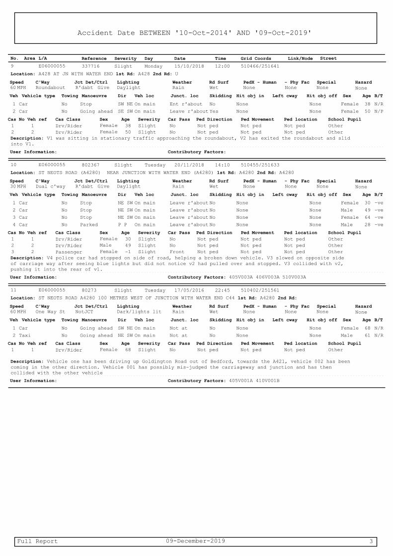
Accident Date BETWEEN '10-Oct-2014' AND '09-Oct-2019'
Reference Severity Date Time Grid CoordsArea DayL/A Link/Node StreetNo.
Slight337716 15/10/2018 510466/25164112:00E06000055
Location: A428 AT JN WITH WATER END 1st Rd: A428 2nd Rd: U
Monday 9
SpeedMPH
C'WayRoundabout
Jct Det/CtrlR'dabt Give
LightingDaylight
WeatherRain
Rd SurfWet
PedX - HumanNone
- Phy FacNone
SpecialNone
Hazard
None 60
Veh Vehicle type Manoeuvre Veh loc Junct. locTowing Skidding Hit obj in Left cway Hit obj off Sex AgeDir B/T
1 StopCar FemaleNo NoEnt r'about None NoneOn main 38SW NE N/R
2 Going aheadCar FemaleNo YesLeave r'about None NoneOn main 50SE SW N/P
Cas No Veh ref Cas Class AgeSex Severity Ped Direction Ped Movement Ped locationCar Pass School Pupil
1 38 1 SlightDrv/Rider Female Not pedNot ped Not pedNo Other
2 50 2 SlightDrv/Rider Female Not pedNot ped Not pedNo OtherDescription: V1 was sitting in stationary traffic approaching the roundabout, V2 has exited the roundabout and slid into V1.
User Information: Contributory Factors:
Slight802367 20/11/2018 510455/25163314:10E06000055
Location: ST NEOTS ROAD (A4280) NEAR JUNCTION WITH WATER END (A4280) 1st Rd: A4280 2nd Rd: A4280
Tuesday 10
SpeedMPH
C'WayDual c'way
Jct Det/CtrlR'dabt Give
LightingDaylight
WeatherRain
Rd SurfWet
PedX - HumanNone
- Phy FacNone
SpecialNone
Hazard
None 30
Veh Vehicle type Manoeuvre Veh loc Junct. locTowing Skidding Hit obj in Left cway Hit obj off Sex AgeDir B/T
1 StopCar FemaleNo NoLeave r'about None NoneOn main 30NE SW -ve
2 StopCar MaleNo NoLeave r'about None NoneOn main 49NE SW -ve
3 StopCar FemaleNo NoLeave r'about None NoneOn main 64NE SW -ve
4 ParkedCar MaleNo NoLeave r'about None NoneOn main 28P P -ve
Cas No Veh ref Cas Class AgeSex Severity Ped Direction Ped Movement Ped locationCar Pass School Pupil
1 30 1 SlightDrv/Rider Female Not pedNot ped Not pedNo Other
2 49 2 SlightDrv/Rider Male Not pedNot ped Not pedNo Other
3 -1 2 SlightPassenger Female Not pedNot ped Not pedFront OtherDescription: V4 police car had stopped on side of road, helping a broken down vehicle. V3 slowed on opposite side of carriage way after seeing blue lights but did not notice v2 had pulled over and stopped. V3 collided with v2, pushing it into the rear of v1.
User Information: Contributory Factors: 405V003A 406V003A 510V003A
Slight80273 17/05/2016 510402/25156122:45E06000055
Location: ST NEOTS ROAD A4280 100 METRES WEST OF JUNCTION WITH WATER END C44 1st Rd: A4280 2nd Rd:
Tuesday 11
SpeedMPH
C'WayOne Way St
Jct Det/CtrlNotJCT
LightingDark/lights lit
WeatherRain
Rd SurfWet
PedX - HumanNone
- Phy FacNone
SpecialNone
Hazard
None 60
Veh Vehicle type Manoeuvre Veh loc Junct. locTowing Skidding Hit obj in Left cway Hit obj off Sex AgeDir B/T
1 Going aheadCar FemaleNo NoNot at None NoneOn main 68SW NE N/R
2 Going aheadTaxi MaleNo NoNot at None NoneOn main 61NE SW N/R
Cas No Veh ref Cas Class AgeSex Severity Ped Direction Ped Movement Ped locationCar Pass School Pupil
1 68 1 SlightDrv/Rider Female Not pedNot ped Not pedNo Other
Description: Vehicle one has been driving up Goldington Road out of Bedford, towards the A421, vehicle 002 has been coming in the other direction. Vehicle 001 has possibly mis-judged the carriageway and junction and has then collided with the other vehicle
User Information: Contributory Factors: 405V001A 410V001B
09-December-2019 3Full Report

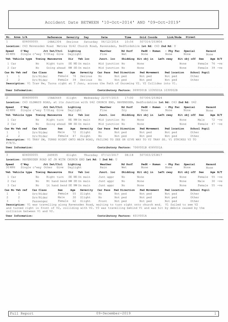
Accident Date BETWEEN '10-Oct-2014' AND '09-Oct-2019'
Reference Severity Date Time Grid CoordsArea DayL/A Link/Node StreetNo.
Serious14BA1304 06/12/2014 507314/25380410:56E06000055
Location: C43 Revensden Road Metres Uc42 Church Road, Ravensden, Bedfordshire 1st Rd: C43 2nd Rd: U
Saturday 1
SpeedMPH
C'WaySingle c'way
Jct Det/CtrlT/Stag Give
LightingDaylight
WeatherFine
Rd SurfWet
PedX - HumanNone
- Phy FacNone
SpecialNone
Hazard
None 40
Veh Vehicle type Manoeuvre Veh loc Junct. locTowing Skidding Hit obj in Left cway Hit obj off Sex AgeDir B/T
1 Right turnCar FemaleNo NoMid junction None NoneOn main 76SE NE -ve
2 Going aheadCar FemaleNo NoMid junction None NoneOn main 39NW SE -ve
Cas No Veh ref Cas Class AgeSex Severity Ped Direction Ped Movement Ped locationCar Pass School Pupil
1 76 1 SeriousDrv/Rider Female Not pedNot ped Not pedNo Other
2 39 2 SeriousDrv/Rider Female Not pedNot ped Not pedNo OtherDescription: V1 Trav Nw, Turns right at T Junc, across the Path of Oncoming V2. V2 Collides into V1.
User Information: Contributory Factors: 999V001B 103V001A 103V002B
Slight15BA0669 22/07/2015 507304/25382417:00E06000055
Location: C43 OLDWAYS ROAD, at its Junction with U42 CHURCH END, RAVENSDEN, Bedfordshire 1st Rd: C43 2nd Rd: U42
Wednesday 2
SpeedMPH
C'WaySingle c'way
Jct Det/CtrlT/Stag Give
LightingDaylight
WeatherFine
Rd SurfDry
PedX - HumanNone
- Phy FacNone
SpecialNone
Hazard
None 40
Veh Vehicle type Manoeuvre Veh loc Junct. locTowing Skidding Hit obj in Left cway Hit obj off Sex AgeDir B/T
1 Right turnCar MaleNo NoMid junction None NoneOn main 72NE NW -ve
2 Going aheadCar FemaleNo NoMid junction None NoneOn main 47NW SE -ve
Cas No Veh ref Cas Class AgeSex Severity Ped Direction Ped Movement Ped locationCar Pass School Pupil
1 72 1 SlightDrv/Rider Male Not pedNot ped Not pedNo Other
2 47 2 SlightDrv/Rider Female Not pedNot ped Not pedNo OtherDescription: V1 TRAV SW, TURNS RIGHT ONTO MAIN ROAD, FAILING TO SEE OR GIVE WAY TO V2 TRAV SE. V1 STRIKES V2 TO F/N/S.
User Information: Contributory Factors: 706V001B 406V001A
Slight249935 07/12/2017 507303/25381708:18E06000055
Location: RAVENSDEN ROAD AT JN WITH CHURCH END 1st Rd: U 2nd Rd: U
Thursday 3
SpeedMPH
C'WaySingle c'way
Jct Det/CtrlOther Give
LightingDaylight
WeatherRain
Rd SurfWet
PedX - HumanNone
- Phy FacNone
SpecialNone
Hazard
None 30
Veh Vehicle type Manoeuvre Veh loc Junct. locTowing Skidding Hit obj in Left cway Hit obj off Sex AgeDir B/T
1 Right turnCar FemaleNo NoJunt appr None NoneOn main 55SE NE -ve
2 Rt hand bendCar MaleNo NoJunt appr None NoneOn main 30NW SE -ve
3 Lt hand bendCar FemaleNo NoJunt appr None NoneOn main 55SE NW -ve
Cas No Veh ref Cas Class AgeSex Severity Ped Direction Ped Movement Ped locationCar Pass School Pupil
1 55 1 SlightDrv/Rider Female Not pedNot ped Not pedNo Other
2 30 2 SlightDrv/Rider Male Not pedNot ped Not pedNo Other
3 62 1 SlightPassenger Female Not pedNot ped Not pedFront OtherDescription: V1 was travelling along Ravensden Road, waiting to turn right onto church end. V1 failed to see V2 and turned right in front of V2, colliding with V2. V3 was travelling behind V1 and was hit by debris caused by the collision between V1 and V2.
User Information: Contributory Factors: 401V001A
09-December-2019 1Full Report
Transport Assessment Addendum Land off north of Hookhams Lane, Salph End
Martin Andrews Consulting Ltd F Revision 0 – June 2020 248‐TA‐02‐0
Appendix F J1: Hookhams Lane / Norse Road: Cycleway Improvements
MAC drawing no. 248‐TA18
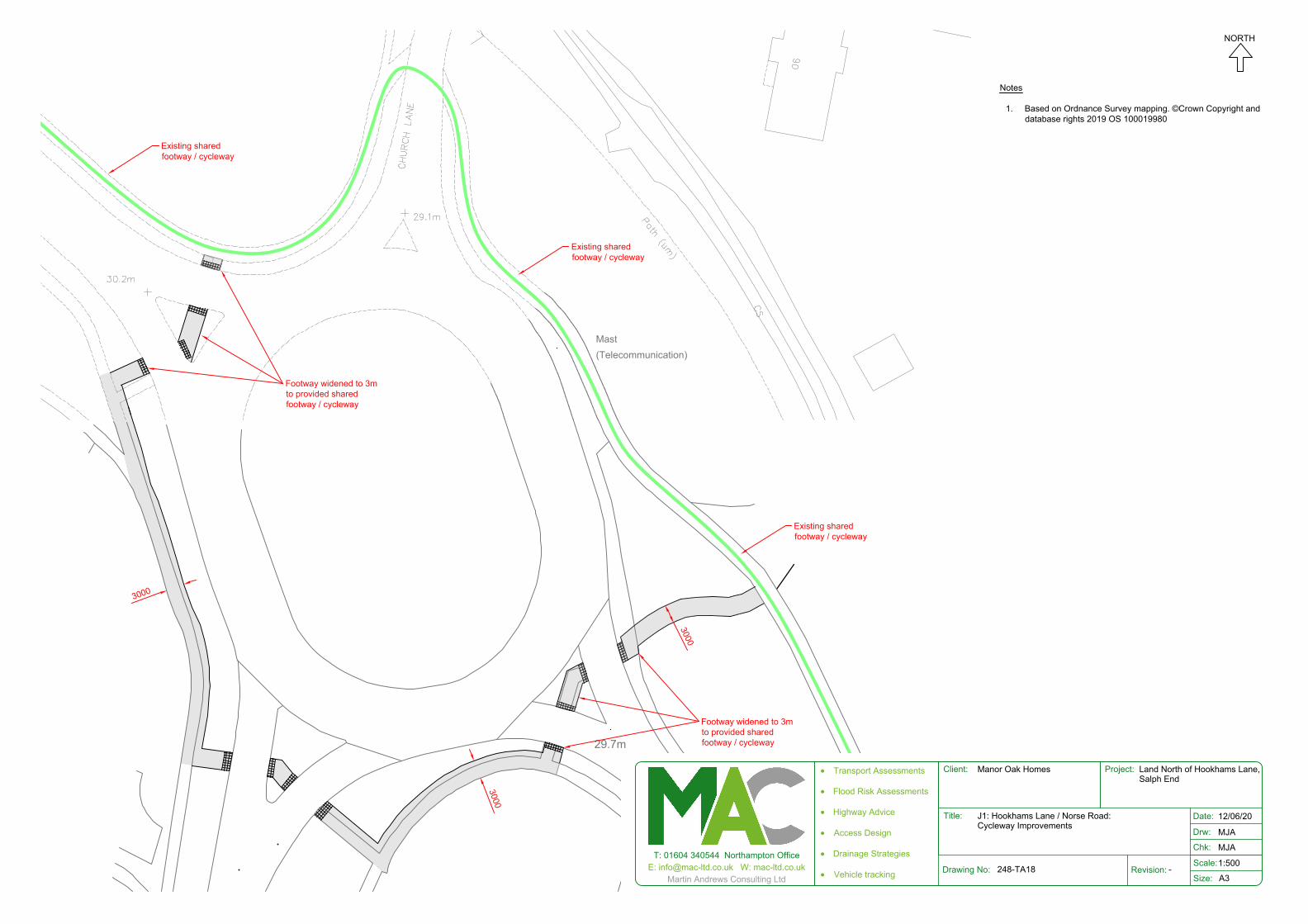
29.7m
NORSE RO
AD
(Telecommunication)Mast
Footway widened to 3mto provided sharedfootway / cycleway
3000
3000
3000
Footway widened to 3mto provided sharedfootway / cycleway
Existing sharedfootway / cycleway
Existing sharedfootway / cycleway
Existing sharedfootway / cycleway
Notes
1. Based on Ordnance Survey mapping. ©Crown Copyright anddatabase rights 2019 OS 100019980
T: 01604 340544 Northampton OfficeE: [email protected] W: mac-ltd.co.uk
Martin Andrews Consulting LtdDrawing No: Revision:
Client: Project:
Title:
Scale:
Size:
Chk:
Drw:
Date:
A3
· Transport Assessments
· Flood Risk Assessments
· Highway Advice
· Access Design
· Drainage Strategies
· Vehicle tracking
Manor Oak Homes Land North of Hookhams Lane, Salph End
J1: Hookhams Lane / Norse Road:Cycleway Improvements
248-TA18 -
12/06/20
MJA
MJA
1:500
NORTH

Transport Assessment Addendum Land off north of Hookhams Lane, Salph End
Martin Andrews Consulting Ltd G Revision 0 – June 2020 248‐TA‐02‐0
Appendix G J5: Ravensden Road / Oldways / Church End: Existing Visibility
MAC drawing no. 248‐TA16

RENHOLD RO
AD
38.7m
37.8m
OLDWAYS ROAD
RENHOLD RO
AD
RENHOLD RO
AD
38.7m
37.8m
OLDWAYS ROAD
RENHOLD RO
AD
Notes
1. Based on Ordnance Survey mapping. ©Crown Copyright anddatabase rights 2019 OS 100019980
Visibility Splay - 2.4m x 120m
Key
NORTH
T: 01604 340544 Northampton OfficeE: [email protected] W: mac-ltd.co.uk
Martin Andrews Consulting LtdDrawing No. Revision
Client: Project:
Title:
Date:
Drw:
Chk:
Size:
· Transport Assessments· Highway Advice
· Flood Risk Assessments· Drainage Strategies
Scale:
A4
Manor Oak Homes Land north of Hookhams LaneSalph End
J5: Ravensden Rd / Oldways Rd / Church EndExisting Visibility
248-TA16 -
10/06/20
MJA
MJA
1:1000

Transport Assessment Addendum Land off north of Hookhams Lane, Salph End
Martin Andrews Consulting Ltd H Revision 0 – June 2020 248‐TA‐02‐0
Appendix H Pedestrian and Cyclist Routes to Key Facilities with Improvements
MAC drawing no. 248‐TA03

S
N
P
Existing dropped kerb.Tactile paving to beprovided
Existing dropped kerb,tactile paving partiallyprovided. Missing tactileto be provided.
Dropped kerb and tactilepaving to be provided.
New uncontrolledcrossing refer to TA11C
Footway widened toremove carriagewayside verge.
Footway / cycleway linkwidened to 3m wherefeasible refer to TA15A
New 2m footway refer toTA16
Reproduced from Ordnance Survey, (c) Crown Copyright 2019.
Notes:
1. The only footway and cycleway connections which are shown are to access marked facilities. Many connections existing which arenot shown on this drawing.
2. Access routes shown to facilities highlighted asa concern by the highway authority. T: 01604 340544 Northampton Office
E: [email protected] W: mac-ltd.co.ukMartin Andrews Consulting Ltd
Drawing No: Revision:
Client: Project:
Title:
Scale:
Size:
Chk:
Drw:
Date:
A3
· Transport Assessments
· Flood Risk Assessments
· Highway Advice
· Access Design
· Drainage Strategies
· Vehicle tracking
Manor Oak Homes Land between Hookhams Laneand Ravensden Rd Salph End, Beds
Pedestrian and Cyclist Routes to Key Facilities with Improvements
248-TA03 -
11/06/20
MJA
MJA
1:5,000
NORTH
Site Boundary
Education - ExistingNursery (N) / Primary (P)Secondary (S)
Village Hall
Existing footway
Key Existing footway - upgraded
Proposed footway
Existing cycleway
Proposed cycleway
Upgraded crossing
New crossing - See TA11

Transport Assessment Addendum Land off north of Hookhams Lane, Salph End
Martin Andrews Consulting Ltd I Revision 0 – June 2020 248‐TA‐02‐0
Appendix I Footway Improvements: Ravensden Road
MAC drawing no. 248‐TA17

Transport Assessment Addendum Land off north of Hookhams Lane, Salph End
Martin Andrews Consulting Ltd J Revision 0 – June 2020 248‐TA‐02‐0
Appendix J Footway Improvements – South of 43 Hookhams Lane
MAC drawing no. 248‐TA15A
