transforming urban dichotomies and challenges of south
TRANSCRIPT
Article
Transforming Urban Dichotomies and Challenges ofSouth Asian Megacities: Rethinking SustainableGrowth of Dhaka, Bangladesh
Mohammad Shahidul Hasan Swapan 1,* ID , Atiq Uz Zaman 1 ID , Tahmina Ahsan 1 andFahmid Ahmed 2
1 School of Built Environment, Curtin University, Bentley, WA 6102, Australia;[email protected] (A.U.Z.), [email protected] (T.A.)
2 School of Architecture and Built Environment, University of Adelaide, Adelaide, SA 5001, Australia;[email protected]
* Correspondence: [email protected]; Tel: +61-(08)-9266-1999
Received: 24 July 2017; Accepted: 2 October 2017; Published: 8 October 2017
Abstract: Dhaka, the capital of Bangladesh, is the eleventh largest megacity city in the world, with apopulation of 18.2 million people living in an area of 1528 km2. This city profile traces the trajectoriesof its urban development to becoming a megacity and characterizes its emerging challenges due toinformal urbanization and climate change impacts. Due to rapid population growth and uncontrolledurbanization, Dhaka currently faces various socio-economic and environmental challenges in aspectssuch as providing basic urban services; reliable transportation framework; constant water and energysupply; effective sanitation; sustainable waste management and affordable housing. Moreover, theurban setting has further deteriorated as Dhaka is already facing various adverse impacts of climatechange. Studies predict that most of the urban sectors, public health and surrounding agricultureand fisheries in Dhaka will be severely impacted by climate change. Dhaka is trying to transformits existing “incremental development” model to an “integrated development” framework in orderto effectively mitigate its extreme urban challenges. The future of Dhaka city significantly relieson the successful execution of integrated infrastructure and service planning, development, andmanagement practices, operating under an accountable and good governance system.
Keywords: megacities; informal urbanization; climate change; sustainable urban management; Dhaka
1. Introduction
Megacities are defined as highly dynamic urban systems having over 10 million inhabitants [1].They are also defined as the largest “urban agglomerations, attract[ing] considerable attentionbecause of their population size, economic, socio-cultural, environmental and political influence,and geographical complexity” [2]. According to the UN [3], currently 9.9 % of the world’s urbanpopulation lives in 23 megacities, a number that is expected to increase to 37 in 2025. More than twothirds of the megacities are located in the developing world, mostly in Asia and Africa, and havebecome primary cities only in recent decades. This is particularly relevant to South Asia, as it hostsfive megacities with than 15 million inhabitants each, viz. Mumbai, Delhi, Kolkata, Dhaka and Karachi.These cities are expanding enormously, primarily on account of rural-to-urban migration, climaticmigration, job opportunities, and reclassification of the metropolitan area [4,5]. Developing countriesoften struggle with the management, planning and governance of these megacities, and result in“unmanaged urbanization creating massive urban infrastructure backlogs, haphazard urban sprawl,and compound environmental problems” [6]. However, there is a lack of study on the urbanizationprocess in megacities. Temporal and spatial patterns of urban challenges due to informal urbanization,
Urban Sci. 2017, 1, 31; doi:10.3390/urbansci1040031 www.mdpi.com/journal/urbansci

Urban Sci. 2017, 1, 31 2 of 20
and vulnerabilities and risks from climate change impacts are rarely explored. A comprehensiveunderstanding of the context and challenges pertaining to these megacities has now become asignificant issue for planners and policy makers to ensure sustainable development for the largesturban agglomerations [7,8].
Dhaka, the capital of Bangladesh, situated in South Asia, is the world’s 11th largest megacity [9].It has emerged as the fastest-growing megacity in recent times [10]. Geographically, the core areaof Dhaka city (belonging to Dhaka City Corporations—North and South) lies between 23.69◦ and23.89◦ North latitudes and 90.33◦ and 90.44◦ East longitudes [4] (Figure 1). The core city covers about127 km2 of land area [11,12]. However, the Dhaka Metropolitan Development Plan spans a bigger areaof 1528 km2 (termed as Dhaka Megacity) by projecting growth spill into six surrounding municipalities(Kadamrasul, Gazipur, Narayanganj, Siddirganj, Savar and Tongi) to form the megacity.
Urban Sci. 2017, 1, 31 2 of 20
urbanization process in megacities. Temporal and spatial patterns of urban challenges due to informal urbanization, and vulnerabilities and risks from climate change impacts are rarely explored. A comprehensive understanding of the context and challenges pertaining to these megacities has now become a significant issue for planners and policy makers to ensure sustainable development for the largest urban agglomerations [7,8].
Dhaka, the capital of Bangladesh, situated in South Asia, is the world’s 11th largest megacity [9]. It has emerged as the fastest-growing megacity in recent times [10]. Geographically, the core area of Dhaka city (belonging to Dhaka City Corporations—North and South) lies between 23.69° and 23.89° North latitudes and 90.33° and 90.44° East longitudes [4] (Figure 1). The core city covers about 127 km2 of land area [11,12]. However, the Dhaka Metropolitan Development Plan spans a bigger area of 1528 km2 (termed as Dhaka Megacity) by projecting growth spill into six surrounding municipalities (Kadamrasul, Gazipur, Narayanganj, Siddirganj, Savar and Tongi) to form the megacity.
Figure 1. Location and administrative map of Dhaka city [13].
With an unprecedented population growth, Dhaka is struggling to ensure the quality of its urban life and sustainable urban growth, including infrastructure, water supply, sanitation and housing [14,15]. Moreover, increasing heat stress and unpredictable rainfall patterns along with climate-induced natural disasters such as drought, flood and cyclones make it more difficult to offer a sustainable livelihood in Dhaka. The heterogeneity of urban form across the city also catalyzes complexity in the required planning actions to face future challenges, including climate change.
This paper aims to contribute to the growing literature reviewing the fastest-growing megacities of the developing world by investigating the informal urbanization process and its impacts on various sectors related to urban infrastructure and services of Dhaka. In doing so, we have tried to reconnect the compound challenges interwoven by population explosion and climate change impacts. A closer look at the urban challenges of Dhaka will also expand our understanding of the urban dichotomies and complexities in megacities. The following sections begin with a literature review characterizing the urbanization process and associated risks and vulnerabilities of megacities.
Figure 1. Location and administrative map of Dhaka city [13].
With an unprecedented population growth, Dhaka is struggling to ensure the quality of itsurban life and sustainable urban growth, including infrastructure, water supply, sanitation andhousing [14,15]. Moreover, increasing heat stress and unpredictable rainfall patterns along withclimate-induced natural disasters such as drought, flood and cyclones make it more difficult to offera sustainable livelihood in Dhaka. The heterogeneity of urban form across the city also catalyzescomplexity in the required planning actions to face future challenges, including climate change.
This paper aims to contribute to the growing literature reviewing the fastest-growing megacitiesof the developing world by investigating the informal urbanization process and its impacts on varioussectors related to urban infrastructure and services of Dhaka. In doing so, we have tried to reconnectthe compound challenges interwoven by population explosion and climate change impacts. A closerlook at the urban challenges of Dhaka will also expand our understanding of the urban dichotomies
Urban Sci. 2017, 1, 31 3 of 20
and complexities in megacities. The following sections begin with a literature review characterizingthe urbanization process and associated risks and vulnerabilities of megacities. An introduction tothe demographic and economic profile of Dhaka is given in Section 3. Section 4 discusses Dhaka’sevolution from small town to megacity. It further evaluates the transformation of the spatial-planningapproach and its impact on the city’s morphology and land-use patterns. The fifth section attempts toaudit multifaceted challenges that Dhaka megacity faces, with specific reference to climate change,infrastructure development, environmental degradation, housing and transportation, which will haveramifications on its future planning and growth. We conclude by portraying a planning vision for futuresustainability, which can help urban planners and researchers to effectively navigate the challenges ofmanaging an emerging megacity. Leading international and local publications, development plansand government publications have been examined to investigate the city development process andrecent challenges emerging due to population explosion and climate change impacts.
2. Urbanization in Megacities: A Theoretical Perspective
Urbanization studies in megacities attract a wide range of theoretical propositions incharacterizing their temporal and spatial growth. In this paper, we focus mainly on the city’s growthpattern and emerging complexities that lead to the growing realization of sustainability and resilientcommunities in the face aggravated risks and climatic vulnerabilities. Although much urbanizationis taking place in megacities, “many of the theories of how cities function remain rooted in thedeveloped world” [16]. Unlike Western cities, megacities are dominated by spontaneous growth andinformal urbanization. Such urbanization trends often create chaotic land-use distribution, whichleads to serious environmental degradation and inadequate urban infrastructure for a fast growingand unevenly distributed population [17]. The concept of informal urbanization appeared in theliterature to define the growth of informal settlements inhabited by the urban poor [18,19]. Due to thehigh volume of urban inflow from rural areas either for income opportunities or as a result of beingdisplaced by climatic events, megacities fail to accommodate additional people. Eventually, the urbanpoor find their way into temporary housing in slums and squats built on public land. With the growingpopulation, an informal economy in the form of street-based self-business, home-based works andconstruction labor provides employment to a significant number of people in megacities in parallelwith formal job sectors [20].
In more recent literature, it is argued that such informality has been exploited by urban elitesexercising power through socio-political networks for land grabbing and manipulating planningdecisions for individual benefit [21]. As a result, unauthorized and illegal development becomes acommon phenomenon in the urbanization process of megacities. In effect, “large urban agglomerationsare expanding and densifying rapidly with only marginal and sporadic planning regulation” [22].The process both exerts pressure on infrastructure and leads to a vulnerable urban environment withfragile urban governance systems. Several case studies reported lack of good governance in planningand service delivery in these cities along with strong presence of informal and illegal networks andactor groups overlapping formal public and private institutions [23–27].
Urban scientists suggest that megacities are at increasing risks of uncontrolled urbanization, socialdisparity and segregation and fragmented urban governance systems. The vulnerabilities have beenfurther multiplied by global environmental change and anthropogenic hazards [28]. Kraas [29] notes“the effects of global environmental and socio-economic change can magnify risks and impair thequality of life for many people, particularly the more vulnerable population groups”. With this addeddimension of urban challenge, growth dynamics and management perspectives have become morecomplex and compound in nature. Recently, scholars have embarked upon more sustainable andresilient urban growth in these large urban agglomerations [29]. The sustainability discourse of urbangrowth in megacities highlights comprehensive understandings of magnitude and interrelationshipsof urban problems. It also suggests an array of adaptive measures related to policy framework,appropriate infrastructure development and improving social capital to become a more resilient

Urban Sci. 2017, 1, 31 4 of 20
community [28]. In line with this, the present paper aims to explore emerging and interrelatedurban challenges, taking Dhaka as a case study, to recommend a sustainable pathway for the growthof megacities.
3. Case Study: Dhaka Megacity
3.1. Demographic Profile
Dhaka megacity accommodates around 18.2 million people and this figure is expected to reach22 million by 2025, at an annual growth rate of 4.4% [9,30]. About 63% of the total population growth iscontributed by in-migration, and the remaining growth is due to natural increase [30]. Dhaka megacityis also one of most densely populated cities of the world having a density of 11,910 persons per km2.The density is even higher in the core region of the city (Dhaka North City Council (DNCC) andDhaka South City Council (DSCC) area), which has significantly increased from 34,629 per km2 in2001 to 49,182 per km2 in 2011, making it an overcrowded and uninhabitable living environment [4].The population data also indicates that 40% of the total population represents dependent age groups,leading to a high dependency ratio and widespread poverty among low-earner groups in the city [31].The key demographic features of the megacity along with the historical trend of population growthare shown in Table 1.
Table 1. Demographic characteristics of Dhaka megacity.
Year Total HH Population Density Sex Ratio (M/F) Literacy Rate HH Size Growth Rate (%)
1951 NA 411,279 4815 165 – 6.4 –1961 127,710 718,766 5796 154 – 5.6 –1974 341,167 2,068,353 6156 137 – 6.1 11.151981 527,311 3,440,147 8547 139 48.1 6 5.221991 1,088,378 6,487,459 4795 126 57 5.4 6.552001 1,920,682 9,672,763 7055 125 65.1 4.6 4.08
2011 a 3,232,683 14,509,100 10,484 113 67.3 4.1 –2016 4,550,000 * 18,200,000 11,910 - - 4.0 -
Note: HH = Households [32]; a Derived from BBS [33]; * Estimated from UN [9].
In terms of the core city area government by two corporations, DNCC has an area of 83 km2
comprising a population of 3,957,302. DSCC, on the other hand, has a smaller area of 45 km2
accommodating 2,288,812. The key demographic and urban features of the city corporations arelisted in Table 2.
Table 2. The key demographic and urban features of Dhaka City corporations area.
Description DNCC DSCC Total
Area 83 km2 45 km2 127 km2
No. of Ward 36 57 93Population 3,957,302 2,288,812 6,246,114
Population density 47,886/km2 50,862/km2 49,182/km2
Holdings 172,254 122,780 295,034Markets 43 78 121
Community Centre 13 36 49Park 42 27 69
Play Ground 55 9 64Public Toilet 37 28 65
Hospital/Clinic 239 193 432Annual budget (2015–2016) $USD (M) 202 $USD (M) 263 $USD (M) 465
Sources: Bhattacharjee and Khan [11]; DNCC [12]; DSCC [34].

Urban Sci. 2017, 1, 31 5 of 20
The demographic statistics reveal a higher number of male than female. The city representspeople from all regions of Bangladesh. The majority of the population, around 90%, is Muslim and 7%is Hindu, and the rest belong to various religious beliefs. About 40% of the city’s population lives in4000 slums and squats, of which the majority is female [35,36]. The landownership pattern is highlyskewed. More than 70% of the city’s population has no access to land, while only 30% own about 80%of the land [4,10].
3.2. Economy of Dhaka
The urban sector in Bangladesh is the main thrust of the economy, which contributes more than60% of the GDP [37]. Dhaka is the prime urban agglomeration and economic hub of the country,having a current GDP of US$ 10 billion. The city offers 43.6% of the total formal employment in thecountry consisting of office jobs, business, and manufacturing industries [30]. The city hosts fivekey manufacturing industries namely: apparel, textiles, furniture, food and beverage, and leather.Dhaka also provides a large scale of informal jobs, including rickshaw operation, street vending, andhousehold services run by the urban poor. The socio-economic profile of the residents shows extremeinequality between the rich and poor in Dhaka [38]. Only 3% of the total population belongs to therich cohorts who enjoy a high standard of living. The rest of the population belongs to either themiddle or the lower-middle income groups, who have to struggle to sustain their life. Corner andDewan [4] record that 45% of the city’s population is defined as urban poor, of which 25% are classifiedas “extremely poor”. The urban poor are mostly located in slum areas of Dhaka city, characterizedby a degraded built environment and unhealthy sanitation conditions. Slums accommodate newlyarrived environmentally displaced and regular migrants from rural areas. Social clustering basedon kinships, district of origin, profession and religion is a very common feature within communitiesliving in slums [10]. Such clusters and social networks provide initial income support, information,accommodation, and access to jobs for newly arrived people.
4. Historical Growth and Urban Planning
Dhaka was established nearly 400 years ago [39]. The location of earlier settlements wasexceptionally strategic due to its accessibility, water communication and trading routes. The earliersettlements of the city were mainly located on the bank of Buriganga River and have graduallyextended towards the north. Due to increasing land scarcity, the city also encroached on low-lyinglands on the eastern and westerns sides. The morphology of the city is predominantly spontaneous andorganic in nature [40], except for a few planned residential neighborhoods developed after the 1980s.
Pre-Mughal Dhaka was a small settlement in the form of a rural town with a trading center. Dhakabecame the capital of the Bengal Subah (province) of the Mughal Empire in 1608 and was namedJahangirnagar, after the Mughal Emperor Jahangir [40–42]. Commercial areas in Pre-Mughal Dhakagrew up around “the fort and the river to the west, and the residential areas mostly spread out in thenortherly direction” [43]. The size of the city increased from 124 km2 to 248 km2 between early to thelate 17th century during the Mughal Empire [44] (Figure 2).
During the early colonial era (1764–1947), the industrial areas were developed by the Europeansincluding the Dutch, the French, and finally by the British [the Indian sub-continent was ruled by theBritish East India Company (1757–1857) and the British Crown (1858–1947)] in the 18th century, due toeasy water communication and a centralized location [45]. Dhaka appeared as one of the foremosttextile-producing cities during the mid-18th century [46].
Dhaka became the capital of the Eastern province of Pakistan in 1947, after the partition of theIndian sub-continent, and hence embarked on becoming a modern metropolis (Figure 3). Post-colonialDhaka urbanized rapidly, and many new developments took place with the expansion of the city inthe north of Dhaka. Motijheel was established in the 1950s as the first central business district (CBD).Later, government housing was built around the CBD. Gradually the majority of the lands that hadbeen gardens, agricultural lands and wetlands were transformed into organic and haphazard built-up

Urban Sci. 2017, 1, 31 6 of 20
areas to accommodate the growing population. The Dhaka Improvement Trust (DIT) was establishedin 1956 under the Town Improvement Act, 1953, to the guide the planning and development of thecity. However, DIT soon developed high-end residential areas such as Gulshan, Banani, Uttara andBaridhara overlooking the largest and growing urban poor [48]. DIT undertook the first masterplanproject for Dhaka city in 1959, covering an area of 830 sq. km., targeting one million residents with anannual population growth rate of only 1.75% [23].Urban Sci. 2017, 1, 31 6 of 20
Figure 2. Historical, administrative and planning boundaries of Dhaka city [13].
During the early colonial era (1764–1947), the industrial areas were developed by the Europeans including the Dutch, the French, and finally by the British [the Indian sub-continent was ruled by the British East India Company (1757–1857) and the British Crown (1858–1947)] in the 18th century, due to easy water communication and a centralized location [45]. Dhaka appeared as one of the foremost textile-producing cities during the mid-18th century [46].
Figure 2. Historical, administrative and planning boundaries of Dhaka city [13].
Although the metropolitan master plans prepared in the 1960s expired in the early 1980s, nomajor planning milestones emerged until 1990 due to the major upheavals during independence fromPakistan in the 1970s, and the military takeovers throughout the 1980s [49]. In the early 1990s, thepolitical restoration of democracy in Bangladesh brought about a broad range of reforms in publicadministration and local governance. In the meantime, DIT was replaced by RAJUK in 1987 under theTown Improvement (Amendment) Act, 1987, through an organizational reform of DIT’s administrativestructure and spatial jurisdiction [48].
A paradigm shift towards democratic metropolitan planning that was initiated in the 1970s cameto be realized in 1991 when a new phase of spatial planning was reinforced by the new generationplans. RAJUK began its journey through designing the Dhaka Metropolitan Development Plan(DMDP), 1997–2015. Unlike rigid master plans, the new planning approach stated strategies andpolicies to optimize existing urban land resources in the short to medium term [50]. However, theplanning process showed much resemblance with rational planning or Geddesian regional planningapproach. The plan was characterized by scoping of an interim review and ensuring sustainable urbandevelopment. The aim of the plan illuminates a strong reflection of the development agenda upheld

Urban Sci. 2017, 1, 31 7 of 20
by the international aid organization. The Detailed Area Plan (DAP) proposed under DMDP was notrealized until 2010 due to bureaucratic and political barriers. Due to the unavailability of any legalplanning framework, haphazard development encroaching wetlands and flood flow zones occurredat a massive scale until 2010 [26]. Although DAP demarcated 21% of the city’s land restricted fordevelopment due to its environmental sensitivity, most of those areas appeared as projects alreadyunder development by private developers, and in some cases government projects as well.Urban Sci. 2017, 1, 31 7 of 20
Figure 3. Temporal map of the evolution of urban planning and development process in Megacity Dhaka (adopted from [47]).
Dhaka became the capital of the Eastern province of Pakistan in 1947, after the partition of the Indian sub-continent, and hence embarked on becoming a modern metropolis (Figure 3). Post-colonial Dhaka urbanized rapidly, and many new developments took place with the expansion of the city in the north of Dhaka. Motijheel was established in the 1950s as the first central business district (CBD). Later, government housing was built around the CBD. Gradually the majority of the lands that had been gardens, agricultural lands and wetlands were transformed into organic and haphazard built-up areas to accommodate the growing population. The Dhaka Improvement Trust (DIT) was established in 1956 under the Town Improvement Act, 1953, to the guide the planning and development of the city. However, DIT soon developed high-end residential areas such as Gulshan, Banani, Uttara and Baridhara overlooking the largest and growing urban poor [48]. DIT undertook the first masterplan project for Dhaka city in 1959, covering an area of 830 sq. km., targeting one million residents with an annual population growth rate of only 1.75% [23].
Although the metropolitan master plans prepared in the 1960s expired in the early 1980s, no major planning milestones emerged until 1990 due to the major upheavals during independence from Pakistan in the 1970s, and the military takeovers throughout the 1980s [49]. In the early 1990s, the political restoration of democracy in Bangladesh brought about a broad range of reforms in public administration and local governance. In the meantime, DIT was replaced by RAJUK in 1987 under the Town Improvement (Amendment) Act, 1987, through an organizational reform of DIT’s administrative structure and spatial jurisdiction [48].
A paradigm shift towards democratic metropolitan planning that was initiated in the 1970s came to be realized in 1991 when a new phase of spatial planning was reinforced by the new generation plans. RAJUK began its journey through designing the Dhaka Metropolitan Development Plan (DMDP), 1997–2015. Unlike rigid master plans, the new planning approach stated strategies and policies to optimize existing urban land resources in the short to medium term [50]. However, the planning process showed much resemblance with rational planning or Geddesian regional planning approach. The plan was characterized by scoping of an interim review and ensuring sustainable urban development. The aim of the plan illuminates a strong reflection of the development agenda upheld by the international aid organization. The Detailed Area Plan (DAP) proposed under DMDP was not realized until 2010 due to bureaucratic and political barriers. Due to the unavailability of any legal planning framework, haphazard development encroaching wetlands and flood flow zones
Figure 3. Temporal map of the evolution of urban planning and development process in MegacityDhaka (adopted from [47]).
Poor urban governance also contributed to such unsustainable growth of the city. It is notedthat planning and development agencies struggle to control this unplanned growth due to a lack ofmanpower. Failure or partial implementation of major planning projects is attributed to deep-rootedbureaucracy, lengthy processes of project approval, and above all, the lack of financial and technicalcapacity of the planning agencies. Ahmed (2010) [51] reports that public departments managedto complete only 71% of the total development projects of the Annual Development Plans during2000–2008. Meanwhile, the biggest land project, which is around 2500 hectares, has been operatedby the public-sector developer RAJUK on the northeastern fringe. In contrast, the binary reality inthis century is the reconstruction of the inner-city Hatirjheel-Begunbari canal, which is the majorurban water intervention for Dhaka in recent history. The project consists of forty hectares of wetlandsintegrated with other wetlands, including massive landscape infrastructure systems such as roads,pedestrian walkways, aqueducts, sewerage, water retention, and a special detailed area plan for thesurrounding neighborhoods.
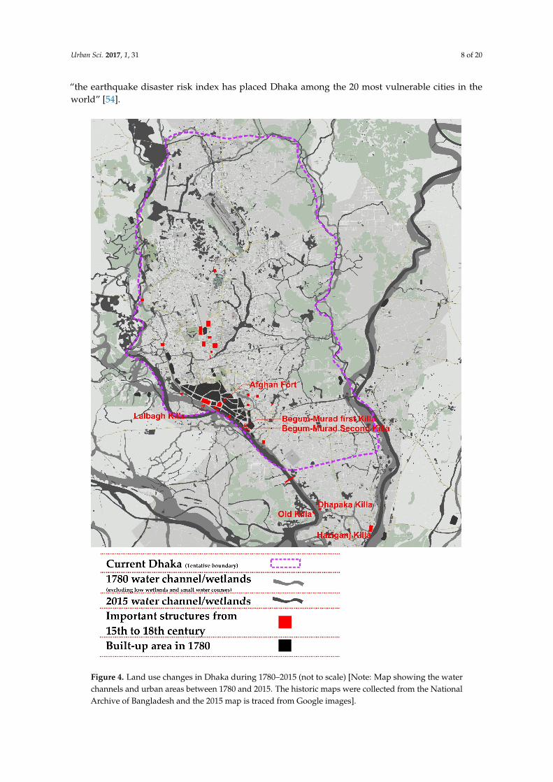
Figure 4 summarizes major land use and morphological changes in Dhaka from 1780 to 2015.It illustrates the change of watercourses and declining wetlands along while outlining the growth ofthe city from only 248 km2 to a 1528 km2 megacity. The land use changes over the centuries suggestsignificant environmental concerns and the failure of major planning initiatives as mentioned above.Contemporary studies on land use and development patterns indicate that new urban areas andsatellite towns are being developed spontaneously and organically on landfills, by both the public andthe private sector development agencies [52]. In many cases, however, the quality of developmenthas not been maintained and has resulted in massive disasters. The Ministry of Relief and DisasterManagement has identified 72,000 buildings in Dhaka that are at risk to earthquakes [53]. Moreover,
Urban Sci. 2017, 1, 31 8 of 20
“the earthquake disaster risk index has placed Dhaka among the 20 most vulnerable cities in theworld” [54].Urban Sci. 2017, 1, 31 9 of 20
Figure 4. Land use changes in Dhaka during 1780-2015 (not to scale) [Note: Map showing the water channels and urban areas between 1780 and 2015. The historic maps were collected from the National Archive of Bangladesh and the 2015 map is traced from Google images].
Figure 4. Land use changes in Dhaka during 1780–2015 (not to scale) [Note: Map showing the waterchannels and urban areas between 1780 and 2015. The historic maps were collected from the NationalArchive of Bangladesh and the 2015 map is traced from Google images].

Urban Sci. 2017, 1, 31 9 of 20
Social exclusion has been taking place, and a large proportion of climatic and economic migrantsare living in the most vulnerable areas of the city along the line of water and land. Eventually constantdisplacement of these people follows due to the expansion of the city by development agencies, throughprofit-venture initiatives. Land speculation has become exclusive as land prices have increased bymore than 500% over the last 30 years as a result of creating value by developing land for housingand new urban areas [55]. While the implementation of DMDP is still questionable due to politicalreasons and increasing pressure from private land developers, last year RAJUK released “a revisedand updated strategic plan for the Dhaka Metropolitan Region for the period of 2016–2035, keeping inperspective the shifting, underlying philosophies of spatial planning, current situation of this territory,and its future vision for recapturing sustainable city development” [30].
The city was previously administered by the single agency called Dhaka Municipality establishedin 1864. In 1978, Dhaka Municipality was awarded the status of Corporation. The Local Government(City Corporation) Amendment Act (2011) divided Dhaka City Corporation into Dhaka NorthCity Corporations (DNCC) and Dhaka South City Corporation (DSCC) in 2011 for subdividing themanagement works [56]. The city corporations are responsible for providing and managing basic urbanservices, solid waste management and community development and health-related projects. It is alsonoted that 55 government agencies are responsible for executing various development projects withincorporations’ jurisdiction, which often result in overlapping competencies and a clash of authority.The planning process also appears mostly bureaucratic, corrupted and non-participatory. As a result,local demands and aspirations are rarely reflected in the execution of the development plan [26].
5. Challenges of an Emerging Megacity
The trend of urbanization in Dhaka city shows typical growth dynamics of megacities. There ispressing demands for urban infrastructure, utilities, and services such as drainage, water supply, solidwaste management, sewerage, sanitation, housing, and transportation. The inadequacy of servicesand lack of good governance in service delivery has given rise to a critical situation. In addition,the ever-growing population puts significant pressure on the city, as well as on the surroundingenvironment. The multifaceted challenges have emerged from informal urbanization and have beenfurther deteriorated by natural and man-made hazards. The following sections provide an audit andanalysis of significant urban challenges to point out appropriate considerations for making sustainableand resilient urban communities in Dhaka.
5.1. Impacts of Climate Change
Over 90% of all urban areas are coastal, putting most cities on Earth at risk of flooding from risingsea levels and stronger and more frequent storms [57] and Dhaka is no exception with regards tovulnerability to climate change. The elevation in Dhaka ranges between 2 and 13 meters above sealevel, which means that even a slight rise in sea level is likely to engulf large parts of the city [58].Climate change will affect Dhaka severely through flooding and water congestion and heat stress [59].A number of studies suggest that climate change will lead to compound problems of environmentaldegradation [60–63]. The key vulnerable sectors in Dhaka due to climate change would be agricultureand fisheries, infrastructure such as housing and transportation, utilities services such as water supplyand sanitation, power supply, and trade and business industries, which will severely impact on theoverall economic activities and most importantly public health and wellbeing [59,64].
Unfortunately, the poorest in society with no or limited access to proper healthcare, water andsanitation are the most vulnerable to the impacts of climate change. The Ministry of Environment andForests in Bangladesh found that drought will increase in some areas due to declining trend of rainfallpatterns induced by climate change [65]. Similar studies found that, in the last 100 years, the averagetemperature in Dhaka has increased by 0.50 degrees Celsius, and in the next 50 years it is expected toincrease by another 1.5–2 degrees [30]. The ageing population and children will be mostly affectedfrom the urban heat island effect, which will intensify due to higher global temperatures. In addition,

Urban Sci. 2017, 1, 31 10 of 20
the distribution of some infectious disease vectors and some allergenic pollen species will increase dueto climate change, which would severely affect local health and wellbeing.
Dhaka has already been affected by the indirect impacts of climate change, most particularlyfrom climate-induced displacement and migration. Every year a significant number of people (around400,000 according to the World Bank’s study) move to Dhaka and live in slums [64]. Due to poorhousing structures and lack of utilities and services, around 70% of the slum dwellers in Dhakaare affected by some sort of environment shock and climate change, particularly from floods [66].Several initiatives to combat the adverse impacts of future risks are underway. Bangladesh Governmenthas prepared a strategic action plan which is built on six key pillars: (i) food security, social protectionand health, (ii) comprehensive disaster management, (iii) infrastructure, (iv) research and knowledgemanagement, (v) mitigation and low carbon development, and (vi) capacity building and institutionalstrengthening. As a part of climate-resilient development, the government has invested aroundUS$10 billion in the past three decades primarily in flood management [Greater Dhaka FloodProtection Project’ (GDFPP)], improving drainage systems, embankments, coastal projection, andcyclone shelter-related projects [67]. Recently a US$2 billion embankment project funded by the UnitedNations and the Netherlands Government is being implemented nationwide to stop flood risks [68].Apart from mitigation actions, significant efforts have been attributed to developing adaptationstrategies. This includes stabilizing housing structures of low-income settlements, introducing floatinggardens to continue food production during floods and diversifying agricultural cropping systems [69].
5.2. Water Supply
Water supply in Dhaka primarily relies on ground water sources. Around 80% of the total watersupplied by the Dhaka Water Supply and Sewerage Authority (DWASA) in the city comes fromground water (with a 26% system loss) and another 20% from surface water sources [30]. The waterdemand in 2015 was 3140 million liters per day (MLD) and the demand will increase to 4858 MLD by2035 [30]. A study from the Institute of Water Modelling suggests that around 149,160 million litersof water (47 days of current water demands) can be harvested during the monsoon season, usingrainwater-harvesting systems [70]. DWASA covers around 75% of the metropolitan areas with a supplyof piped water to 12.5 million residents, whereas 25% of the residents (including slum dwellers) facewater shortages on account of inadequate water supply [70]. Poor maintenance of the water supplysystem and power blackouts often interrupt the water supply system in Dhaka. Most of the slumdwellers (about 4.1 million out of 4.5 million) do not have formal access to the DWASA water supplysystem [71]. A constant withdrawal of groundwater from the Dhaka catchment areas creates hugerisks of the gradual depletion of the groundwater level and pollutes the groundwater with arsenic,dissolved ammonia, iron and manganese. It is noted that due to heavy pollution and contaminationof surface water from domestic waste and sewage systems, Dhaka will face significant challenges insourcing drinking water.
5.3. Solid Waste Management (SWM)
Each day the residents of Dhaka generate around 4000 tons of solid waste including industrialwaste (300 t/day) and medical waste (200 t/day) with a generation rate of 0.34 kg/person/day [30].Due to a lack of funds and infrastructure, DNCC and DSCC only collected half of the waste generatedby its residents in 2012 [72]. Only 14–17% of the total municipal budget is used for SWM, which isapproximately US$ 0.5 per capita per year [73]. The waste management system in Dhaka is primarilyoperated by the community-based informal collection and recycling system. About 120,000 peopleare involved in the informal recycling trade chain in Dhaka City. Any valuable materials are eitherreused or sold by their owners or by the informal waste-pickers. The formal waste collection systemthat the DCC provides to the residents is facilitated through 1030 roadside containers and 41 privatecontainers [74]. A recent report showed that the DCC only operates around 511 garbage containers indifferent areas of Dhaka city [75], which is equivalent to one bin for every 32,093 people. Due to the

Urban Sci. 2017, 1, 31 11 of 20
lack of a waste infrastructure that is hampered by a narrow road network, the DCC does not provideany door-to-door collection systems. From its roadside collection points, the DCC collects wasteand transfers it to landfill sites. Community-based private micro-organizations collect waste fromhouseholds instead, and transfer this to the DCC’s designated waste collection and transfer points.
5.4. Drainage and Hydrology
Dhaka is situated in a low-lying area with a high risk of flooding, as the city is surrounded by anumber of major rivers and more than 50 water channels [76]. This makes Dhaka’s surface hydrologyvery complex. As part of its flood protection strategy, Dhaka implemented a number of dykes orembankments and interim boundaries. This also creates water logging within the protected city areaduring the monsoons, as there are insufficient drainage and water pumping systems. Studies revealthat permanent wetlands have been reduced from 14% to 4% between 1967 and 2010 and during thesame time period Dhaka lost around 52% lowlands and 33% water bodies around Dhaka city [30].
Dhaka built its first city protection embankment after the 1988 flood on the western edge alongwith a bypass road. This western development model transformed the water system from natural andgravity drainage to mechanical pumping drainage for western Dhaka, which needed a huge amountof energy to operate. Moreover, fortification against water, instead of living with water, altered theland formation pattern in Dhaka; hence land developers and illegal occupiers filled land without anyconsideration for natural drainage or the ecosystem. This proved to be cataclysmic in the long run. Inaddition, unplanned underground drainage systems across the city lead to severe waterlogging on thestreets. A World Bank study predicts a cumulative financial loss of around US$ 1.4 billion in the next35 years, if waterlogging and urban flooding are not addressed [77].
5.5. Sewerage and Sanitation
The underground sewer network provided by the DWASA covers only 30% of the urban land areaand 20% of the population [30]. Another 30% of the population is estimated to dispose off their sewageby connecting into the drainage networks and open channels. The remaining 50% of the residents inDhaka are served by localized sanitation facilities like septic tanks and soak pits that are, for the mostpart, poorly or inadequately designed. The sanitation facilities in slum areas are even shabbier. A largeamount of domestic and human waste is held in situ these areas, some of which gets washed into thewater bodies during the wet season. This leads to the proliferation of viral diseases and communicablediseases due to poor hygiene and non-existent sanitation systems in the slums. DWASA operatesonly one sewage treatment plant at Pagla (PSTP), about 8 km from the city, on an area of 1.105 km2.PSTP has a design capacity of 120 MLD (peak flow rate) while the current sewage generated within thecatchment areas, served by the centralized sewerage system is approximately 250–300 MLD. Due todamage to the trunk sewer mains and sewerage system, the actual flow rate entering the Pagla STP isapproximately 30–40 MLD, i.e., the treatment plant is significantly under-loaded and should ideallyprovide a high level of treatment [30].
5.6. Formal vs. Informal Housing
Dhaka faces extreme challenges in housing and related infrastructure due to rapid populationgrowth and an influx of the migrant population. According to Seraj and Islam [78], every year at least100,000 new housing units are required in Dhaka to fulfill the growing housing demand. Around 90%of the total housing supply in Dhaka is provided by private housing sector, and public housing onlyaccommodates around 10% of the market supply [30]. Often the housing development in Dhakafollows an unplanned and informal “incremental development” model where the housing along withthe relevant service infrastructure is developed in various steps by adding a “little more” each time.This unplanned informal incremental development leads to violating building codes and a lack ofnecessary safety features for the infrastructure.

Urban Sci. 2017, 1, 31 12 of 20
The total housing shortage in Bangladesh was estimated to be 5.0 million units by the end ofthe year 2000. In response to this demand, roughly 25,000 housing units are supplied annually bythe private sector, while the government contributes a very negligible portion [79]. The demandfor vertical expansion in Dhaka has increased exponentially in recent years as land is scarce, and anincreasing population, accompanied by urban migration, has increased the demand for housing [80].High-rise residential development has also gained popularity, as the horizontal expansion of Dhakais not possible due to a lack of buildable land within the city center [45], and barriers such as thebuilt-up urban core and the low-lying flood plains [28,77,80]. Private real estate companies emerged inDhaka in the early 1980s with residential apartment development projects. The number of real estatecompanies has increased dramatically from only 42 in 1988 to more than 1500 in 2014. A recent studyhas identified 181 residential settlement development projects (plots and apartments) in the greaterDhaka city area [81].
However, the location of the projects indicates an outward trend, occupying peripheral areas,spontaneously resulting in significant environmental concerns. Moreover, the quality of the residentialbuildings in the new schemes has deteriorated due to wetland encroachments, violations of predefinedland use, illegal plot subdivisions, and increased building heights. Besides, over 78% of the lowermiddle-income group and 70.73% of the middle-income families cannot afford housing in the city [30]as it serves only the upper strata of the society. As a result, most of the people either rent in unplannedperipherals or squat illegally in slum areas. Dhaka has the highest slum population among six majorcities in Bangladesh. Since informal settlements are not recognized by the legal judicial systems due toland ownership and other legal disputes, almost all informal settlements in Dhaka have no provisionof the most basic urban services such as water supply, sanitation and energy supply. As a result,housing and living conditions in the slums are very poor and often associated with a higher level ofhealth risks.
5.7. Transport
The public transport system in Dhaka does not meet the requirements of its population and peopleheavily depend on private cars and non-motorized rickshaws (three-wheeler cycle). The transportsystem in Dhaka is significantly problematic due to a lack of proper infrastructure, inadequatemotorized public transport, and disregard of traffic rules. Every day an estimated 442,000 commutersuse 183 transport routes, including air, water, rail and roads [30]. Dhaka’s public transport comprises“a fragmented, loosely organized, and weakly regulated system of approximately 7000 buses andminibuses”, which is managed by more than 60 companies [82]. A study on the travel pattern of Dhakacity reports that work-based travelling accounts for 44.7% of the total trips generated by inhabitants [6].Other significant trips are generated for school (17.7%) and homes (12.6%). Air pollution fromtransportation is a major concern for Dhaka. Dhaka has the highest air pollution in the context ofambient air quality and multi-pollutant index compared to other mega cities (Figure 5).

Urban Sci. 2017, 1, 31 13 of 20
Urban Sci. 2017, 1, 31 14 of 20
Megacities based on ambient air quality measurements (μg m−3) (TSP = total suspended particles).
Multi-pollutant index (MPI) (MPI denotes the combined level of the three criteria pollutants (i.e., TSP, SO2, and NO2) in view of the World Health Organisation (WHO) Guidelines for Air Quality of selected megacities
Figure 5. Comparative assessment of air quality in selected megacities [83]
The mobility pattern of Dhaka remains highly human-powered as 64% of trips in the city are by rickshaw, 28% by bus, and the remaining are related to car, motorbike and auto-rickshaw [84]. It is expected that by 2035 the modal share of public transport will increase significantly, whereas the modal share of rickshaw trips will decrease to 20% [30]. Dhaka not only faces the challenges of a poor and insufficient road network, but it also faces challenges from vehicle conditions. Over 95% of the buses that operate everyday do not comply with the requirements under the Motor Vehicles Act, and only 75000 rickshaws have legal permits against a total of 700000 rickshaws operating in the city [85]. Vehicular emission is one of the main sources of air pollution as it imposes a significant health risk to the residents of Dhaka. The city also had the worst multi-pollutant index (MPI) of all the megacities in 2000, which was caused by an ever-growing population, unfit vehicles, and low-quality fuel [6] (Figure 5).
Dhaka’s transport sector experiences a very high congestion level due to a higher population density, a poor mix of land uses, and limited space for new transport infrastructure. Frequent traffic congestion is severely detrimental to the working population as well as to the overall economy. It is estimated that congestion costs US$3 billion a year and the city loses over 8 million working hours daily [86]. As part of the traffic solution, the government has undertaken comprehensive transport planning and infrastructure programs. Among others, the Dhaka elevated expressway, around 47 km long, is one of the biggest transport infrastructure projects with a budget of US$1.2 billion, and it will be completed under a public-private partnership approach. However, traffic experts do not find
0
100
200
300
400
500
600
700
800NO2
SO2
TSP
-0.5
0
0.5
1
1.5
2
2.5
3
Figure 5. Comparative assessment of air quality in selected megacities [83].
The mobility pattern of Dhaka remains highly human-powered as 64% of trips in the city areby rickshaw, 28% by bus, and the remaining are related to car, motorbike and auto-rickshaw [84].It is expected that by 2035 the modal share of public transport will increase significantly, whereas themodal share of rickshaw trips will decrease to 20% [30]. Dhaka not only faces the challenges of a poorand insufficient road network, but it also faces challenges from vehicle conditions. Over 95% of thebuses that operate everyday do not comply with the requirements under the Motor Vehicles Act, andonly 75,000 rickshaws have legal permits against a total of 700,000 rickshaws operating in the city [85].Vehicular emission is one of the main sources of air pollution as it imposes a significant health risk tothe residents of Dhaka. The city also had the worst multi-pollutant index (MPI) of all the megacitiesin 2000, which was caused by an ever-growing population, unfit vehicles, and low-quality fuel [6](Figure 5).
Dhaka’s transport sector experiences a very high congestion level due to a higher populationdensity, a poor mix of land uses, and limited space for new transport infrastructure. Frequent trafficcongestion is severely detrimental to the working population as well as to the overall economy. It isestimated that congestion costs US$3 billion a year and the city loses over 8 million working hoursdaily [86]. As part of the traffic solution, the government has undertaken comprehensive transport

Urban Sci. 2017, 1, 31 14 of 20
planning and infrastructure programs. Among others, the Dhaka elevated expressway, around 47 kmlong, is one of the biggest transport infrastructure projects with a budget of US$1.2 billion, and it will becompleted under a public-private partnership approach. However, traffic experts do not find flyoverprojects an effective solution, because 650 street intersections in Dhaka need to be made functional firstin order to address this problem [87].
6. Discussion: Planning for Future Sustainability
This article provides a profound picture of the historical evolution of Dhaka to understand itsgrowth and contemporary issues. The paper tries to emphasize the issue of urban population growthand its multifaceted impact on a city’s infrastructure and development. It is evident that the increasinggap between economic opportunities and service provisions is leading to inadequate infrastructuralservices and urban life style. While the policy makers have bigger plans to make Dhaka a livable andmore resilient metropolis, the challenges should be handled efficiently and collaboratively. Figure 6portrays the overall framework for an integrated and sustainable response for making cities livableand resilient. The premise of the framework supports a holistic approach to address the emergingurban issues that prevail in megacities. The following sections discuss the opportunities and pathwaysto overcome the risks and challenges of Dhaka, which are identified and analyzed in Section 4.
Urban Sci. 2017, 1, 31 15 of 20
flyover projects an effective solution, because 650 street intersections in Dhaka need to be made functional first in order to address this problem [87].
6. Discussion: Planning for Future Sustainability
This article provides a profound picture of the historical evolution of Dhaka to understand its growth and contemporary issues. The paper tries to emphasize the issue of urban population growth and its multifaceted impact on a city’s infrastructure and development. It is evident that the increasing gap between economic opportunities and service provisions is leading to inadequate infrastructural services and urban life style. While the policy makers have bigger plans to make Dhaka a livable and more resilient metropolis, the challenges should be handled efficiently and collaboratively. Figure 6 portrays the overall framework for an integrated and sustainable response for making cities livable and resilient. The premise of the framework supports a holistic approach to address the emerging urban issues that prevail in megacities. The following sections discuss the opportunities and pathways to overcome the risks and challenges of Dhaka, which are identified and analyzed in Section 4.
Figure 6. A framework for sustainable urban development in megacities.
Urban planning systems in Bangladesh are characterized by a top-down planning approach influenced by politicized patron-client networks and bureaucracy. The administrative practice and service delivery approach growing out of its colonial legacy are predominantly manual and paper-based. In terms of planning administration, large land-related databases are manually recorded and physically filed in numerous bound register books accompanied by hand-drawn maps using pen and paper. This inefficient and cumbersome system thus tends to contribute to non-transparent systems subject to delayed processing of citizens’ requests for information and susceptible to potential corruption and wastage of resources. Tracing progress of applications for building approvals, for example, can be difficult simply due to manual data storage and retrieval, and also often due to deliberate corruption.
The journey from city management to modern urban planning practice suggests that a number of opportunities to develop local institutional capacities and systems may have been wasted. As European colonizers left, “western” systems continued to be incorporated, taking the focus away from the need to adopt, augment, and revive traditional governance and administration systems. The challenge of dealing with an unprecedented influx of refugees and migrants could largely explain why urban administrators opted for the imported state-of-the-art planning technology to handle large problems through equally large-scale plans. Consequently, knowledge of the local context or cultural sensitivity did not significantly temper the planning approach. A good-governance framework also suggests formal access to the information of land, property and housing. There is a growing demand in improving e-government to ensure efficient information management and effective urban service delivery systems [88].
Figure 6. A framework for sustainable urban development in megacities.
Urban planning systems in Bangladesh are characterized by a top-down planning approachinfluenced by politicized patron-client networks and bureaucracy. The administrative practiceand service delivery approach growing out of its colonial legacy are predominantly manual andpaper-based. In terms of planning administration, large land-related databases are manually recordedand physically filed in numerous bound register books accompanied by hand-drawn maps usingpen and paper. This inefficient and cumbersome system thus tends to contribute to non-transparentsystems subject to delayed processing of citizens’ requests for information and susceptible to potentialcorruption and wastage of resources. Tracing progress of applications for building approvals, forexample, can be difficult simply due to manual data storage and retrieval, and also often due todeliberate corruption.
The journey from city management to modern urban planning practice suggests that a number ofopportunities to develop local institutional capacities and systems may have been wasted. As Europeancolonizers left, “western” systems continued to be incorporated, taking the focus away from the needto adopt, augment, and revive traditional governance and administration systems. The challengeof dealing with an unprecedented influx of refugees and migrants could largely explain why urbanadministrators opted for the imported state-of-the-art planning technology to handle large problemsthrough equally large-scale plans. Consequently, knowledge of the local context or cultural sensitivitydid not significantly temper the planning approach. A good-governance framework also suggests

Urban Sci. 2017, 1, 31 15 of 20
formal access to the information of land, property and housing. There is a growing demand inimproving e-government to ensure efficient information management and effective urban servicedelivery systems [88].
The infrastructural development trend in Dhaka mostly follows an “incremental developmentmodel”, where development activities occur incrementally, depending on the then-prevailing needsand circumstances. However, by comparison, the pace of infrastructure development significantlylags behind urbanization over time. One of the key reasons is the lack of integration between thedevelopment plan and the implementation of recommended development strategies. The protectionof water bodies and natural channels is very important in order to ensure an effective drainage systemin Dhaka. The provision of separate sewage and storm water drainage facilities are required in thismegacity to improve health and sanitation. The city also needs to revitalize the surrounding riversurgently, so that surface water can be used for its water supply instead of ground water. An effectivewaste management system is considered to be a benchmark of good governance; unfortunately,Dhaka cannot even collect 100% of the waste generated by its residents on a day-to-day basis.The integration of the informal waste recycling system under the aegis of greater public-privateparticipation would improve the overall waste management system in Dhaka.
The housing sector faces various challenges too, as there is a lack of proper control in both formaland informal development processes. The public housing agency should provide more affordablehousing, as the average housing prices are beyond the financial capacity of most of the lower- andmiddle-income people in Dhaka. The government should provide financial assistance and sustainableguidelines for a neighborhood-based development model instead of a plot-based model or apartmenthousing. Improving living conditions in slum areas is also critical as more than one third of Dhaka’sresidents are living in these areas.
The city has taken several initiatives such as the development of an elevated expressway,flyovers and the plan of rapid transit systems, which would improve the mobility of people inDhaka. Constructing ring roads and revitalizing the surrounding waterways can significantly improvethe overall transportation system in Dhaka. Imposing higher penalties for traffic violations couldalso contribute to the improvement of transport systems in the city. All these initiatives should beundertaken through an integrated and good-governance framework, since urban planning, land use,and infrastructure are inter-linked and complex in nature. The megacity thus requires immediateattention to modernize its planning functions and services for sustainable growth, and for utilizing thecomplete potential of the people, economy and infrastructure.
Finally, while the megacities in developing countries are not the major contributors of greenhousegas (GHG) emissions, there is a “growing exposure and vulnerability of these cities to climatechange, due to a combination of poor socio-economic conditions and inefficient urban planningand management” [28]. It requires sound land-use planning and consensus-based implementationmechanisms to stop the trend of informal urbanization process. In addition, regenerating alternativeurban centers can be useful to decentralize the flow of rural-urban migration. A number studies suggestvarious adaptive measures including urban agriculture for food security during a disaster period,prioritizing risks and vulnerabilities to take graduated actions, and practicing more inclusive planningfor local decision making [89]. A new wave of literature highlights the importance of improving socialnetworks of individuals with relatives, immediate neighbors and local institutions, which has potentialfor making communities more resilient and capable of fast recovery from shocks [90]. However, itis imperative to ensure integration among all the sectors to achieve a sustainable growth within thecurrent urban context.
7. Conclusions
In this paper, we have tried to trace the growth of a megacity and its informal urbanization processin Dhaka. In this regard, we have shed light on urban planning and development issues that affectthe livelihoods of the urbanites. The analysis reveals the root cause of the problem and has shown
Urban Sci. 2017, 1, 31 16 of 20
how overwhelming population and increasing density exerts pressure on infrastructure and localenvironment. Since the scope of a horizontal expansion is limited and challenging due to low-lyingflood plain agricultural land in the surrounding peri-urban area, vertical expansion is undeniably anoption for accommodating the growing urban population in Dhaka. Unfortunately, most of the housingdevelopment in Dhaka is currently driven by private entities following an unplanned incrementaldevelopment model with limited supervision and assistance from local government, which often leadsto the violation of building codes and unsafe construction practices.
Moreover, climatic hazards intensify the magnitude of the problems, leaving citizens with anundefined future. Dhaka is currently facing multifaceted urban challenges due to a lack of goodgovernance. The Detailed Area Plan proposed under DMDP does not integrate and consider localstakeholders’ interests, which makes it more challenging to successfully implement DAP in Dhaka.
The findings of the article communicate critical urban challenges to the academics andthe practitioners to guide the development patterns of the cities that accommodate the largestconcentrations of urban population. The audit and analysis of the urban challenges suggest thedevelopment of a more comprehensive and integrated planning framework that recognizes theinterrelationships of multifaceted problems. A greater role of promoting awareness, self-efficacyand improved social capital needs to be equally voiced to ensure a sustainable growth of megacitiessuch as Dhaka.
Author Contributions: Mohammad Swapan and Atiq Zaman conceived and designed the research paper.Mohammad Swapan developed the theoretical orientation and contributed in exploring planning history ofDhaka and the discussion sections. Atiq Zaman and Tahmina Ahsan analyzed the urban challenges of megacityand the conclusion. Fahmid Ahmed contributed in describing the historical development of Dhaka and preparedthe map to trace the land use changes.
Conflicts of Interest: The authors declare no conflict of interest.
References
1. Pelling, M.; Blackburn, S. (Eds.) Executive Summary. In Megacities and the Coast: Risk, Resilience andTransformation; Routledge: New York, NY, USA, 2013.
2. Taubenböck, H.; Esch, T.; Felbier, A.; Wiesner, M.; Roth, A.; Dech, S. Monitoring urbanization in mega citiesfrom space. Remote Sens. Environ. 2012, 117, 162–176. [CrossRef]
3. UN. World Urbanization Prospects (The 2011 Revision); United Nations: New York, NY, USA, 2012.4. Corner, R.J.; Dewan, A.M. (Eds.) Introduction. In Dhaka Megacity: Geospatial Perspectives on Urbanisation,
Environment and Health; Springer: New York, NY, USA, 2014; pp. 1–22.5. Yokohari, M.; Takeuchi, K.; Watanabe, T.; Yokota, S. Beyond greenbelts and zoning: A new planning concept
for the environment of Asian mega-cities. Landsc. Urban Plan. 2000, 47, 159–171. [CrossRef]6. Kabir, A. The Urban Spatial Structure of Employment and Its Impacts on Transportation and Urban Development:
A Case Study of Dhaka Megacity; University of New South Wales: Sydney, Austrilia, 2013.7. UN. World Urbanization Prospects (The 2014 Revision); United Nations: New York, NY, USA, 2015.8. WB. System of Cities—Harnessing Urbanization for Growth and Poverty Alleviation; World Bank: Washington,
DC, USA, 2009.9. UN. The World’s Cities in 2016. In World Urbanization Prospects: Data Booklet (ST/ESA/SER.A/392);
United Nations: New York, NY, USA, 2016.10. Hossain, S. Social formations of the megacity of Dhaka: A review essay. Cities 2013, 30, 252–254. [CrossRef]11. Bhattacharjee, P.P.; Khan, M.R. Govt to Double Size of Dhaka City Area. Available online: http://www.
thedailystar.net/frontpage/govt-double-size-dhaka-city-area-1219972 (accessed on 10 May 2017).12. DNCC. Dhaka North City Corporation at a Glance; Dhaka North City Council: Dhaka, Bangladesh, 2017.13. Islam, S. Banglapedia—The National Encyclopedia of Bangladesh; Dhaka City Corporation: Dhaka, Bangladesh,
2012.14. Degert, I.; Parikh, P.; Kabir, R. Sustainability assessment of a slum upgrading intervention in Bangladesh.
Cities 2016, 56, 63–73. [CrossRef]
Urban Sci. 2017, 1, 31 17 of 20
15. Haque, S.J.; Onodera, S.; Shimizu, Y. An overview of the effects of urbanization on the quantity and qualityof groundwater in South Asian megacities. Limnology 2013, 14, 135–145. [CrossRef]
16. Roy, A. Urban informality: Toward an epistemology of planning. J. Am. Plan. Assoc. 2005, 71, 147–158.[CrossRef]
17. McGee, T.G. The emergence of desakota regions in Asia: Expanding a hypothesis. In The Extended Metropolis:Settlement Transition in Asia Ginsburg; University of Hawaii Press: Honolulu, HI, USA, 1991.
18. Hackenbroch, K.; Hossain, S.; Altrock, U.; Schoon, S.; Sterly, H. Informality, urban governance and the state:Negotiations of space in Dhaka and the Pearl River Delta. Int. Dev. Plan. Rev. 2016, 38, 229–253. [CrossRef]
19. Hossain, S. The production of space in the negotiation of water and electricity supply in a bosti of Dhaka.Habitat Int. 2012, 36, 68–77. [CrossRef]
20. Daniels, P.W. Urban challenges: The formal and informal economies in mega-cities. Cities 2004, 21, 501–511.[CrossRef]
21. Porter, L.; Lombard, M.; Huxley, M.; Ingin, A.K.; Islam, T.; Briggs, J.; Rukmana, D.; Devlin, R.; Watson, V.Informality, the commons and the paradoxes for planning: Concepts and debates for informality andplanning self-made cities: Ordinary informality? The reordering of a Romany neighbourhood the landformalisation process and the peri-urban zone of Dar es Salaam, Tanzania street vendors and planning inIndonesian cities informal urbanism in the USA: New challenges for theory and practice engaging withcitizenship and urban struggle through an informality lens. Plan. Theory Pract. 2011, 12, 115–153.
22. Baumgart, S.; Kreibich, V. Informal Urbanization—Historical and Geographical Perspectives. disP Plan. Rev.2011, 47, 12–23. [CrossRef]
23. Bari, M.; Efroymson, D. Detailed Area Plan (DAP) for Dhaka Metropolitan Development Plan (DMDP): A CriticalReview; WBB Trust: Dhaka, Bangladesh, 2009.
24. Khan, M.H. Patron-client networks and the economic effects of corruption in Asia. Eur. J. Dev. Res. 1998, 10,15–39. [CrossRef]
25. Sarker, A.E. Patron-client politics and its implications for good governance in Bangladesh. Int. J. Public Adm.2008, 31, 1416–1440. [CrossRef]
26. Swapan, M.S.H. Who participates and who does not? Adapting community participation model fordeveloping countries. Cities 2016, 53, 70–77. [CrossRef]
27. TIB. TIB Condemns Government Decision to Legalize Illegal Housing Projects; Demands Cancellation; TransparencyInternational Bangladesh: Dhaka, Bangladesh, 2012.
28. Roy, M. Planning for sustainable urbanisation in fast growing cities: Mitigation and adaptation issuesaddressed in Dhaka, Bangladesh. Habitat Int. 2009, 33, 276–286. [CrossRef]
29. Kraas, F. Megacities and global change: Key priorities. Geogr. J. 2007, 173, 79–82. [CrossRef]30. RAJUK. Dhaka Structure Plan 2016–2035; Rajdhani Unnayan Kartripakkha: Dhaka, Bangladesh, 2015.31. Mridha, A.M.M.H.; Moore, G.T. The Quality of Life in Dhaka, Bangladesh: Neighborhood Quality as a Major
Component of Residential Satisfaction. In Investigating Quality of Urban Life: Theory, Methods, and EmpiricalResearch; Marans, R.W., Stimson, R.J., Eds.; Springer: New York, NY, USA, 2005.
32. BBS. Population Census—2001 (Vol. 3): National Series, Urban Area Report; Bangladesh Bureau of Statistics:Dhaka, Bangladesh, 2008.
33. BBS. Population and Housing Census 2011 (Community Series)—Dhaka, Gazipur, Narayanganj; BangladeshBureau of Statistics: Dhaka, Bangladesh, 2012.
34. DSCC. Dhaka South City Corporation—Services; Dhaka South City Council: Dhaka, Bangladesh, 2017.35. Islam, N.; Mahbub, A.; Nazem, N.I.; Angeles, G.; Lance, P. Slums of Urban Bangladesh : Mapping and Census,
2005; Centre for Urban Studies, NIPORT and MEASURE Evaluation: Dhaka, Bangladesh, 2006.36. Mahmud, S. Women and the transformation of domestic spaces for income generation in Dhaka bustees.
Cities 2003, 20, 321–329. [CrossRef]37. Choe, K.; Roberts, B. Competitive Cities Competitive Cities in the 21st Century: Cluster-Based Local Economic
Development Mandaluyan City; Asian Development Bank: Manila, Philippines, 2011.38. Siddiqui, K.; Ahmed, J.; Siddique, K.; Huq, S.; Hossain, A.; Nazimud-Doula, S.; Rezawana, N. Social Formation
in Dhaka, 1985–2005: A Longitudinal Study of Society in a Third World Megacity; Ashgate Publishing Limited:Farnham, UK, 2010.
39. Ahmad, S.; Balaban, O.; Doll, C.N.; Dreyfus, M. Delhi Revisited. Cities 2013, 31, 641–653. [CrossRef]

Urban Sci. 2017, 1, 31 18 of 20
40. Mahmud, S.; Duyar-Kienast, U. Spontaneous settlements in Turkey and Bangladesh: Preconditions ofemergence and environmental quality of gecekondu settlements and bustees. Cities 2001, 18, 271–280.[CrossRef]
41. Ahmed, S.U. Dhaka Past, Present, Future; Asiatic Society of Bangladesh: Dhaka, Bangladesh, 2009.42. Chowdhury, M.; Shahidul, H. Growth of capital Dhaka 1608–2010. In 400 Years of Capital Dhaka and Beyond;
Hafiz, R., Rabbani, G., Eds.; Asiatic Society Bangladesh: Dhaka, Bangladesh, Bangladesh, 2011.43. Ahmed, S.J.; Nahiduzzaman, K.M.; Bramley, G. From a Town to a Megacity: 400 Years of Growth. In Dhaka
Megacity: Geospatial Perspectives on Urbanisation, Environment and Health; Corner, R.J., Dewan, A.M., Eds.;Springer: New York, NY, USA, 2014; pp. 23–44.
44. Karim, A. Origin and development of Mughal Dhaka. In Dhaka: Past Present Future, 2nd ed.; Ahmed, S.U.,Ed.; The Asiatic Society of Bangladesh: Dhaka, Bangladesh, 2009; pp. 34–55.
45. Chowdhury, A.; Faruqui, S. Physical growth of Dhaka city. In Dhaka: Past Present Future, 2nd ed.; Ahmed, S.U.,Ed.; The Asiatic Society of Bangladesh: Dhaka, Bangladesh, 2009; pp. 56–76.
46. Mohaimen, A. Dhaka Master Plan Report of 1917 by Patrick Geddes; Bangla Translated Version with anIntroduction; Dhaka City Museum: Dhaka, Bangladesh, 1990.
47. Banerjee, T.; Chakravorty, S. Transfer of Planning Technology and Local Political Economy: A RetrospectiveAnalysis of Calcutta’s Planning. J. Am. Plan. Assoc. 1994, 60, 71–82. [CrossRef]
48. Rahman, G. Town Planning and Political Culture of Planning in Bangladesh; A H Development PublishingHouse: Dhaka, Bangladesh, 2008.
49. Westergaard, K.; Alam, M. Local government in Bangladesh: Past experiences and yet another try. World Dev.1995, 23, 679–690. [CrossRef]
50. RAJUK. Dhaka Metropolitan Development Planning: Terms of Reference (TOR) for Detailed Area Plan;Rajdhani Unnayan Kartripakkha: Dhaka, Bangladesh, 2000.
51. Ahmed, S. Problems of ADP Implementation in Bangladesh: An Analytical Review; BRAC University: Dhaka,Bangladesh, 2010.
52. Hossain, N. History of Commercial Development in Dhaka and the Spatial Significance of SpontaneousRetail Growth. IOSR J. Humanit. Soc. Sci. IOSR-JHSS 2014, 19, 66–73. [CrossRef]
53. Mamun, S. Earthquake: 72,000 buildings at risk in Dhaka. Available online: http://archive.dhakatribune.com/bangladesh/2016/jan/04/72000-building-risk-during-earthquake-dhaka (accessed on 10 May 2017).
54. Ahmed, S.; Ahmed, A.T. Disaster Risks and Risk Mitigation in Dhaka/Other Cities. In Proceedings of theGlobal Campaign on Making Cities Resilient, New Delhi, India, 8–9 June 2010.
55. Hafiz, R. The Urban Frontiers of Dhaka: Creating Space above the Water. In Urbanization in Bangladesh:Emerging Challenges; Jahan, S., Zaman, M., Eds.; Bangladesh Institute of Planners: Dhaka, Bangladesh, 2004.
56. DSCC. About DSCC (Dhaka South City Corporation); Dhaka South City Corporation: Dhaka, Bangladesh, 2012.57. C40. Ending Climate Change-Begins in the City. Available online: http://www.c40.org/ending-climate-
change-begins-in-the-city (accessed on 15 May 2017).58. UN-Habitat. State of the World’s Cities 2008/2009—Harmonious Citie; United Nations Human Settlements
Programme: London, UK, 2008.59. Alam, M.; Rabbani, M.G. Vulnerabilities and responses to climate change for Dhaka. Environ. Urban. 2007,
19, 81–97. [CrossRef]60. Amin, S.M.A.; Rahman, A. Opportunities and Challenges of Urban and Peri-urban Agriculture to Face
Climate Change: A Critical Analysis of Policy and Urban Governance of Dhaka City. In The Security of Water,Food, Energy and Liveability of Cities; Springer: New York, NY, USA, 2014; pp. 365–382.
61. Araos, M.; Ford, J.; Berrang-Ford, L.; Biesbroek, R.; Moser, S. Climate change adaptation planning for GlobalSouth megacities: The case of Dhaka. J. Environ. Policy Plan. 2016. [CrossRef]
62. Banu, S.; Hu, W.; Guo, Y.; Hurst, C.; Tong, S. Projecting the impact of climate change on dengue transmissionin Dhaka, Bangladesh. Environ. Int. 2014, 63, 137–142. [CrossRef] [PubMed]
63. Black, R.; Kniveton, D.; Schmidt-Verkerk, K. Migration and climate change: Toward an integrated assessmentof sensitivity. In Disentangling Migration and Climate Change; Springer: New York, NY, USA, 2013; pp. 29–53.
64. Rahman, A.; Mallick, D. Climate change impacts on cities of developing countries: A case study on Dhaka.In Proceedings of the C40 Tokyo Conference on Climate Change—Adaptation Measures for Sustainable LowCarbon Cities, Tokyo, Japan, 22–24 October 2008.

Urban Sci. 2017, 1, 31 19 of 20
65. MoEF. Climate Change and Health in Bangladesh: Information Brief ; Ministry of Environment and Forest (MoEF):Dhaka, Bangladesh, 2012.
66. McPherson, P. Dhaka: The City where Climate Refugees Are Already a Reality; The Guardian: Dhaka, Bangladesh,2015.
67. MoEF. Bangladesh Climate Change Strategy and Action Plan 2009; Ministry of Environment and Forest (MoEF):Dhaka, Bangladesh, 2009.
68. Cardno, C.A. Massive Flood Protection Project under Way in Bangladesh. Available online: http://www.asce.org/magazine/20150203-massive-flood-protection-project-under-way-in-bangladesh/ (accessed on12 June 2017).
69. Swapan, M.S.H. Community level adaptation strategies for agricultural production in saline prone southwestcoastal region of Bangladesh. In Integrated Water Resources Management and Challenges of the SustainableDevelopment (IHP-VII Series on Groundwater No. 4); UNESCO: Paris, France, 2012.
70. Islam, M.M.; Chou, F.F.; Kabir, M.R. Feasibility and acceptability study of rainwater use to the acute watershortage areas in Dhaka City, Bangladesh. Nat. Hazards 2011, 56, 93–111. [CrossRef]
71. Maswood, M.H. Capital’s 41 Lakh Slum Dwellers Get No Water Supply from DWASA. Available online:http://www.ngof.org/common/details/280 (accessed on 10 May 2017).
72. DCC. Solid Waste Management in Dhaka, Bangladesh; Dhaka City Corporation: Dhaka, Bangladesh, 2013.73. Matter, A.; Dietschi, M.; Zurbrügg, C. Improving the informal recycling sector through segregation of waste
in the household–The case of Dhaka Bangladesh. Habitat Int. 2013, 38, 150–156. [CrossRef]74. DCC. The Study on the Solid Waste Management in Dhaka City (Clean Dhaka Master Plan): Final Report (Volume 2);
Dhaka City Corporation: Dhaka, Bangladesh, 2005.75. Khan, K.Z.; Rashid, A. Brisk Business Thru’ Waste Collection; Prothom Alo: Dhaka, Bangladesh, 2014.76. Mowla, Q.A.; Islam, M.S. Natural Drainage System and Water Logging in Dhaka: Measures to address the
Problems. J. Bangladesh Inst. Plan. 2013, 6, 23–33.77. Alam, H. Without Water for Weeks. Available online: http://www.thedailystar.net/without-water-for-
weeks-22606 (accessed on 15 May 2017).78. Seraj, T.M.; Islam, M.A. Detailed Area Plan: Proposals to Meet Housing Demand in Dhaka. In Dhaka
Metropolitan Development Area and Its Planning Problems, Issues and Policies; Jahan, S., Kalam, A.K.M.A., Eds.;Bangladesh Institute of Planners: Dhaka, Bangladesh, 2013.
79. Barua, S.; Mridha, A.; Khan, R. Housing Real Estate Sector in Bangladesh Present Status and PoliciesImplications. ASA Univ. Rev. 2010, 4, 239–253.
80. Alam, M.J.; Ahmad, M.M. Impacts of environmental laws on land development and developers in DhakaCity, Bangladesh. Int. J. Environ. Sustain. Dev. 2011, 10, 169–188. [CrossRef]
81. Sikder, S.K.; Eanes, F.; Asmelash, H.B.; Kar, S.; Koetter, T. The Contribution of Energy-Optimized UrbanPlanning to Efficient Resource Use–A Case Study on Residential Settlement Development in Dhaka City,Bangladesh. Sustainability 2016, 8, 119. [CrossRef]
82. Zegras, P.C.; Eros, E.; Butts, K.; Resor, E.; Kennedy, S.; Ching, A.; Mamun, M. Tracing a path to knowledge?Indicative user impacts of introducing a public transport map in Dhaka, Bangladesh. Camb. J. Reg. Econ. Soc.2014, 8, 113–129. [CrossRef]
83. Gurjar, B.; Butler, T.; Lawrence, M.; Lelieveld, J. Evaluation of emissions and air quality in megacities.Atmos. Environ. 2008, 42, 1593–1606. [CrossRef]
84. Hossain, M.; Susilo, Y. Rickshaw use and social impacts in Dhaka, Bangladesh. Transp. Res. Rec. J. Transp.Res. Board 2011, 2239, 74–83. [CrossRef]
85. Mahmud, K.; Gope, K.; Chowdhury, S.M.R. Possible causes & solutions of traffic jam and their impact on theeconomy of Dhaka City. J. Manag. Sustain. 2012, 2, 112.
86. Khan, S.M.; Hoque, M.S. Traffic Flow Interruptions in Dhaka City: Is Smooth Traffic Flow Possible?J. Precidency Univ. 2013, 2, 46–54.
87. Morshed, A. Rethinking the Roots of Dhaka’s Traffic Congestion. Available online: http://www.thedailystar.net/op-ed/politics/rethinking-the-roots-dhakas-traffic-congestion-130456 (accessed on 10 May 2017).
88. Doytsher, Y.; Kelly, P.; Khouri, R.; Mclaren, R.; Potsiou, C. Rapid Urbanization and Mega Cities: The Need forSpatial Information Management; Research study by FIG Commission; International Federation of Surveyors.FIG Commission 3: Copenhagen, Denmark, 2010; Volume 3.

Urban Sci. 2017, 1, 31 20 of 20
89. Hunt, A.; Watkiss, P. Climate change impacts and adaptation in cities: A review of the literature. Clim. Chang.2011, 104, 13–49. [CrossRef]
90. Islam, R.; Walkerden, G. How bonding and bridging networks contribute to disaster resilience and recoveryon the Bangladeshi coast. Int. J. Disaster Risk Reduct. 2014, 10, 281–291. [CrossRef]
© 2017 by the authors. Licensee MDPI, Basel, Switzerland. This article is an open accessarticle distributed under the terms and conditions of the Creative Commons Attribution(CC BY) license (http://creativecommons.org/licenses/by/4.0/).