traffic study and conceptual designs for intersection … … · · 2017-12-15traffic study and...
TRANSCRIPT
Prepared by:
803 Summer Street Boston, Massachusetts 02127
50 Congress Street, Suite 935 Boston, Massachusetts 02109
TRAFFIC STUDY AND CONCEPTUAL DESIGNS for Intersection Improvements at
FELLSWAY EAST AND HIGHLAND AVENUE
Malden, Massachusetts
July 2016
Prepared for:
Department of Conservation and Recreation
251 Causeway Street, Suite 900
Boston, MA 02114

Fellsway East and Highland Avenue
Malden, Massachusetts July 2016
ES-1
Executive Summary
Introduction BSC Group, working jointly with Kittelson & Associates, Inc. (KAI), have prepared this Traffic Study for the Massachusetts Department of Conservation and Recreation (DCR) in order to document existing safety issues and develop conceptual design improvements for the intersection of Fellsway East and Highland Avenue in Malden, Massachusetts. The intersection of Fellsway East and Highland Avenue experiences a high number of crashes which prompted DCR to find ways to improve safety at this key location. In the past, this intersection was ranked number 77 on the 2006 ‐2008 Statewide Top 200 Intersection Crash list. It is along a heavily travelled corridor used by commuters and local traffic to avoid congestion on I‐93, Route 1, and communities north of this location, as well as to access parks and other facilities owned and maintained by DCR. Study Methodology This traffic study seeks to identify the existing operational and safety issues present at the intersection, discuss conceptual design alternatives, and review the benefits and drawbacks of each alternative. A key element of this project has been to maintain the character of a parkway while increasing safety and improving traffic operations. The objectives of the study are to analyze the existing conditions, identify safety and operational issues, and provide alternatives which would improve safety and operations for all modes of users at the intersection.
This study involves the collection and analysis of traffic volume data, review of existing conditions, projection of future traffic volumes, and evaluation and development of various conceptual design improvement alternatives. The major tasks include:
Collection of traffic volume and roadway data;
Collection and analysis of crash data;
Intersection capacity analyses;
Development of potential intersection improvement alternatives; and
Recommendation of short‐ and long‐term improvements. Transportation Issues The intersection is characterized by several operational and safety issues, including but not limited to the following:
High number of crashes
Lack of sufficient traffic control
Wide pavement areas

Fellsway East and Highland Avenue
Malden, Massachusetts July 2016
ES-2
Non‐conformance to standard vehicle right‐of‐way rules of the road
Outdated, conflicting, or missing signage
Long pedestrian crossings
High vehicle approach speeds
High weekday morning peak hour volumes
Long queues and delays on approaches Existing Conditions The collected traffic volumes on Fellsway East show that volumes during the weekday morning peak hour, particularly in the southbound direction, constitute a higher than normal percentage of the overall daily traffic along this roadway. The directional distributions on Fellsway East are highly skewed, indicating that this roadway is used mainly by commuters traveling predominantly southbound towards Boston during the morning peak hours and northbound away from the city during the afternoon peak hours. Collected speed data indicates that vehicles on Fellsway East are traveling well above the posted speed limit and, particularly on Fellsway East north of Glenwood Street traveling away from the intersection, vehicles are traveling at nearly double the posted speed limit (47 MPH). Field observations indicated that vehicles traveling along Fellsway East seldom slowed down as they traveled through the intersection since they are not under any traffic control. As part of this Traffic Study, intersection crash reports were collected from the Massachusetts State Police and the City of Malden through MassDOT. Data from these reports were reviewed and analyzed, resulting in the following findings:
During the five years reviewed (2011 to 2015), an average of 10.4 crashes per year occurred at the intersection
During the most recent three year period (2013 to 2015), the number of crashes have increased, with an average of 13 crashes per year.
81% (42 crashes) of crashes occurred due to vehicles colliding at an angle.
In 73% (38 crashes) of crashes, the cause was identified by police as “failure to yield.”
45% (19 crashes) of angle crashes occurred at the point of intersection of Fellsway East Northbound and Highland Avenue Southeastbound. 33% (14 crashes) occurred at the point of intersection of Fellsway East Southbound and Highland Avenue Northwestbound.
The majority of crashes (9 total) occurred between 12:00 PM and 1:00 PM. The second most common hour for crashes (7 total) was between 4:00 PM and 5:00 PM.
35% (18 crashes) of crashes at this intersection resulted in personal injuries.
In three crashes, vehicles struck at an angle were then pushed into other vehicles.
69% (16 crashes) of crashes occurred outside the peak periods (7‐9 AM and 4‐6 PM)
42% (22 crashes) of crashes occurred between the months of August and October.
The calculated crash rate for the intersection is more than double both the MassDOT average Statewide and District 4 (which includes the City of Malden) rates.
Based on the high percentage of angle crashes (81 percent), BSC believes that the leading causes of crashes at this intersection are: confusion over which vehicles have the right of way and which must yield; high vehicle speeds entering the intersection; and driver aggression after having to wait in long

Fellsway East and Highland Avenue
Malden, Massachusetts July 2016
ES-3
queues and delays. The crash trends do not indicate any extenuating circumstances for the crashes, such as roadway or weather conditions or poor lighting. Design Alternatives While keeping in mind the overarching goals of improving traffic operations and increasing safety, the design team produced three alternative improvement concepts, categorized into proposed short‐term and long‐term improvements. It should be noted that DCR has engaged with another firm to perform a study of the existing and potential future improvements to bicycle amenities along the Fellsway East corridor. The results of this study were not available prior to the completion of this Traffic Study, however any findings from the bicycle study should be incorporated into the final design improvements at the intersection of Fellsway East and Highland Avenue. Alternative 1 would involve the implementation of various short‐term and relatively low‐cost improvements that could be implemented in order to clarify vehicular right of way, control travel speeds, evaluate regional traffic, and monitor the potential long‐term improvements. The intersection currently operates most closely to a typical roundabout, therefore each of these improvements is intended to modify the intersection operations to act as such. The improvements would include installation and replacement of signs, reduction of travel lanes, and improvement/clarification of yield‐control operations to reduce driver confusion. Additional traffic counts are also suggested to fully understand the regional traffic volumes and travel patterns. Alternative 2 would involve constructing a traffic signal at the intersection, including improving pedestrian accommodations; providing landscaping opportunities; removing the existing central oval island; extending the medians along Fellsway East further into the intersection; reducing the radii of several intersection corners; and reducing the number of travel lanes on Fellsway East northbound from three to two travel lanes, thereby providing a formalized parking lane and the potential for a bicycle lane. Based on the traffic volume patterns, BSC is recommending that the Fellsway East southbound left‐turn lane operate as a combined left‐through lane, with a permitted left‐turn movement; during the weekday morning peak hours, this movement would essentially operate as a left‐turn only lane, while the rest of the day it would be able to operate as an additional through lane. A signal warrant analysis indicates that three of the nine MUTCD warrants were met, justifying the potential installation of a traffic signal. Alternative 3 would involve modifying the existing intersection geometry to develop a roundabout. While the existing intersection design acts as a circular intersection, it does not meet several of the guiding principles of roundabout design in the United States. Three roundabout conceptual designs were evaluated. Alternative 3A for a single‐lane roundabout features a single‐lane on each approach and exit, as well as a single circulatory lane. Alternative 3B features a second general use southbound lane to help accommodate for heavy southbound through volumes in the weekday morning peak hour. Under Alternative 3C, the additional southbound lane is for left turns only onto Highland Avenue and Glenwood Street. All designs fit within the existing roadway, while modifying the central island design to more effectively direct vehicles through the intersection.

Fellsway East and Highland Avenue
Malden, Massachusetts July 2016
ES-4
Comparison of Alternatives Capacity analyses were performed for the existing intersection layout and for all of the proposed alternatives utilizing 2016 Existing Condition traffic volumes. Capacity analyses were also performed using 2026 Future Condition traffic volumes for the proposed signalization alternative, as well as for the single lane and southbound left‐turn lane roundabout options. The delay and queue impacts to the Highland Avenue approach were considered too great during the weekday morning peak hour under the two‐lane southbound approach roundabout to consider for review under Future Conditions. The results of the capacity analyses using 2026 Future Conditions traffic volumes indicated that the overall intersection delays are lowest under Alternative 3C, which analyzed a roundabout with an exclusive left‐turn lane on the Fellsway East southbound approach. Order of magnitude cost estimates were prepared for each of the design alternatives. It is estimated that the Alternative 1 short‐term improvements would cost approximately $40,000 to implement, while the long‐term signalization or roundabout alternatives would cost approximately $610,000 and $330,000, respectively. The cost estimates were calculated based on broad‐scope assumptions and, while they include contingencies for certain unknowns, do not take into consideration specific elements that may come up during a complete design process. Conclusions and Recommendations Given the aforementioned goals of the study – to improve vehicular operations and increase safety at the intersection – the following factors were taken into consideration when evaluating each of the alternatives:
Delays and queues on the critical movements of the intersection during the peak periods.
Delays for the overall intersection
Improvements to pedestrian accommodations, including shortened crossing distances
Reduction in approach speeds, particularly along Fellsway East
Cost of construction/implementation, including long‐term maintenance
The existing characteristic of the intersection, which most closely resembles a roundabout
Based on the above factors, we recommend Alternative 3C (exclusive southbound left‐turn lane roundabout) be further considered as the long‐term design improvement at the intersection. In conclusion, it is the opinion of BSC Group and Kittelson & Associates, Inc. that there are a variety of short‐term improvements can be made almost immediately and with relatively low cost. Each of the long‐term improvements suggested in this report would require further engineering design and analysis in order to be fully implemented, such as field survey, utility design and relocation, and consideration of bicycle accommodations. In summary, this Traffic Study has documented the existing conditions and has evaluated several design alternatives for the consideration of DCR at the intersection of Fellsway East and Highland Avenue in Malden, Massachusetts.

Fellsway East and Highland Avenue
Malden, Massachusetts July 2016
i
Table of Contents
EXECUTIVE SUMMARY ........................................................................................................ 1
CHAPTER 1: INTRODUCTION ...................................................................................................... 1 1.1. PROJECT BACKGROUND ............................................................................................... 1 1.2. OBJECTIVES ................................................................................................................... 1 1.3. STUDY METHODOLOGY ................................................................................................ 1
CHAPTER 2: EXISTING CONDITIONS ........................................................................................... 2 2.1 DESCRIPTION OF STUDY AREA ..................................................................................... 2 2.2 TRANSPORTATION ISSUES ............................................................................................ 5 2.3 TRAFFIC VOLUMES ....................................................................................................... 7 2.3.1 DAILY TRAFFIC VOLUMES AND PATTERNS ................................................................... 7 2.3.2 SPEED DATA ................................................................................................................ 10 2.3.3 PEAK HOUR TURNING MOVEMENT VOLUMES .......................................................... 10 2.3.4 PEDESTRIAN AND BICYCLE COUNTS ........................................................................... 10 2.3.5 SEASONAL ADJUSTMENTS .......................................................................................... 10 2.1 SAFETY ANALYSIS ........................................................................................................ 14
CHAPTER 3: DESIGN ALTERNATIVES ........................................................................................ 19 3.1 ALTERNATIVE 1 –SHORT‐TERM MODIFICATIONS ....................................................... 19 3.2 ALTERNATIVE 2 –SIGNALIZATION ............................................................................... 22 3.2.1 SIGNAL WARRANT ANALYSIS ...................................................................................... 22 3.2.2 SIGNALIZATION CONCEPT .......................................................................................... 23 3.3 ALTERNATIVE 3 – ROUNDABOUT ............................................................................... 25
CHAPTER 4: ANALYSIS OF ALTERNATIVES ................................................................................ 27 4.1 FUTURE TRAFFIC VOLUMES........................................................................................ 27 4.2 CAPACITY ANALYSES METHODOLOGY........................................................................ 27 4.3 CAPACITY ANALYSES UNDER EXISTING CONDITIONS ................................................. 31 4.4 CAPACITY ANALYSES UNDER FUTURE CONDITIONS ................................................... 32 4.5 COMPARISON OF ALTERNATIVES ............................................................................... 33
CHAPTER 5: COST ANALYSIS .................................................................................................... 34
CHAPTER 6: CONCLUSIONS AND RECOMMENDATIONS .......................................................... 35

Table of Contents - Continued
Fellsway East and Highland Avenue
Malden, Massachusetts July 2016
ii
LIST OF TABLES
Table 1: Traffic Volume Summary ......................................................................................................... 7 Table 2: ATR Vehicle Speed Data ........................................................................................................... 10 Table 3: Summary of Crash Data ........................................................................................................... 14 Table 4: Calculated Crash Rates ............................................................................................................ 18 Table 5: Warrant Analysis ...................................................................................................................... 22 Table 6: Level of Service Designations .................................................................................................. 30 Table 7: Level of Service Summary – 2016 Existing Condition Volumes ............................................... 31 Table 8: Level of Service Summary – 2026 Future Condition Volumes ................................................. 32 Table 9: Conceptual Level Cost Estimates ............................................................................................. 34
LIST OF FIGURES
Figure 1: Project Location 4 Figure 2: Hourly Variation along Fellsway East North of Glenwood Street ............................................ 8Figure 3: Hourly Variation along Fellsway East North of Pine Street ...................................................... 8Figure 4: Hourly Variation along Highland Avenue West of Fellsway East ............................................. 9Figure 5: Hourly Variation along Highland Avenue South of Glenwood Street ...................................... 9Figure 6: 2016 Existing Condition Weekday Morning Peak Hour Traffic Volumes ............................... 11Figure 7: 2016 Existing Condition Weekday Afternoon Peak Hour Traffic Volumes ............................ 12Figure 8: 2016 Existing Condition Weekday Pedestrian and Bicycle Counts ........................................ 13Figure 9: Crash Locations 15 Figure 10: Manner of Collision .............................................................................................................. 16Figure 11: Crash Severity ....................................................................................................................... 16Figure 12: Light Condition 17 Figure 13: Roadway Condition .............................................................................................................. 17Figure 14: Hourly Distribution of Crashes ............................................................................................. 17Figure 15: Monthly Distribution of Crashes .......................................................................................... 17Figure 16: Proposed Alternative 1 – Short‐Term Modifications ........................................................... 21Figure 17: Proposed Alternative 2 ‐ Signalization ................................................................................. 24Figure 18: Proposed Alternative 3C – Roundabout (Southbound Left‐Turn Lane) ............................... 26Figure 19: 2026 Future Condition Weekday Morning Peak Hour Traffic Volumes ............................... 28Figure 20: 2026 Future Condition Weekday Afternoon Peak Hour Traffic Volumes ............................ 29
Fellsway East and Highland Avenue
Malden, Massachusetts July 2016
1
Chapter 1: Introduction
1.1. Project Background
BSC Group, working jointly with Kittelson & Associates, Inc. (KAI), have prepared this Traffic Study for the Massachusetts Department of Conservation and Recreation (DCR) in order to document existing safety issues and develop conceptual design improvements for the intersection of Fellsway East and Highland Avenue in Malden, Massachusetts. The intersection of Fellsway East and Highland Avenue experiences a high number of crashes which prompted DCR to find ways to improve safety at this key location. In the past, this intersection was ranked number 77 on the 2006 ‐2008 Statewide Top 200 Intersection Crash list. It is along a heavily travelled corridor used by commuters and local traffic to avoid congestion on I‐93, Route 1, and communities north of this location, as well as to access parks and other facilities owned and maintained by DCR. This traffic study seeks to identify the existing operational and safety issues present at the intersection, discuss conceptual design alternatives, and review the benefits and drawbacks of each alternative. A key element of this project has been to maintain the character of a parkway while increasing safety and improving traffic operations.
1.2. Objectives
The objectives of the study are to analyze the existing conditions, identify safety and operational issues, and provide alternatives which would improve safety and operations for all modes of users at the intersection.
1.3. Study Methodology
This study involves the collection and analysis of traffic volume data, review of existing conditions, projection of future traffic volumes, and evaluation and development of various conceptual design improvement alternatives. The major tasks include:
Collection of traffic volume and roadway data;
Collection and analysis of crash data;
Intersection capacity analyses;
Development of potential intersection improvement alternatives; and
Recommendation of short‐ and long‐term improvements.

Fellsway East and Highland Avenue
Malden, Massachusetts July 2016
2
Chapter 2: Existing Conditions
2.1 Description of Study Area
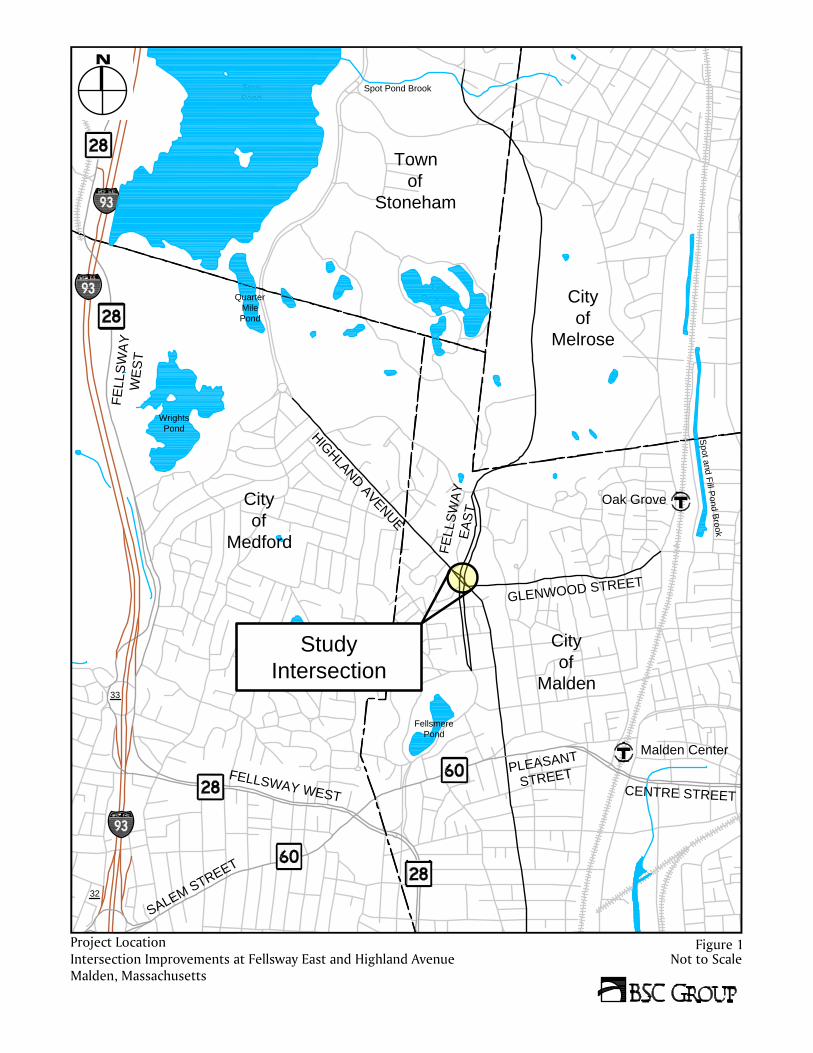
The intersection of Fellsway East and Highland Avenue has an oval traffic island in the center. The geometry of this intersection has not changed in design since its redesign in 1938 despite changes in traffic volumes and travel patterns. Today, the intersection is along a heavily travelled corridor used by commuters and local traffic to avoid congestion on I‐93 and access parks and other facilities owned and maintained by DCR. Amerige Field, a multi‐use recreation area with soccer, baseball, tennis courts, and a playground, is located approximately one quarter of a mile south of the study intersection. Figure 1 shows the location of the intersection.
Fellsway East is a connecting parkway within the DCR park system. It is classified as an urban minor arterial that travels through the municipalities of Stoneham, Malden, Melrose and Medford. Originally designed over 100 years ago as a parkway, it is now frequently used by commuters. The Fellsway East southbound approach has two general‐use travel lanes. The northbound approach has three general‐use travel lanes; however the eastern‐most lane acts as a de facto parking lane, thereby reducing the number of travel lanes to two. A wide (approximately 32 feet) landscaped and tree‐lined median separates the northbound and southbound traffic. Trucks and buses are prohibited from traveling on Fellsway East. Currently, there is no traffic control on Fellsway East; vehicles traveling northbound and southbound are under free operation. Highland Avenue in the study area is under the jurisdiction of the City of Malden, and it travels from Woodland Road in the City of Medford in the northwest and intersects Fellsway East diagonally before turning south for nearly a mile and a half through the City of Malden. At the intersection, Highland Avenue provides one general use travel lane in each direction; however during the
Fellsway East at Highland Avenue looking Northerly

Fellsway East and Highland Avenue
Malden, Massachusetts July 2016
3
weekday morning peak hours, the southeastbound approach operates as two lanes. The Massachusetts Bay Transportation Authority (MBTA) bus route 99 travels along Highland Avenue through the study area intersection between the Boston Regional Medical Center and the Wellington MBTA Station. At its intersection with Fellsway East, traffic control at the Highland Avenue approaches is marked and signed as “stop then yield”. Vehicles traveling eastbound on Highland Avenue must first stop to find a gap in vehicles traveling southbound along Fellsway East, then enter the intersection and, at the median on Fellsway East, must yield to vehicles traveling northbound on Fellsway East. Vehicles traveling westbound on Highland Avenue must do the same, but must stop then yield for opposite directions of travel on Fellsway East. Meanwhile all vehicles should keep right of the central oval island. This operation is confusing for drivers, especially those new to the intersection, as it operates as a non‐standard hybrid of both a roundabout and a stop‐controlled intersection. Glenwood Street provides one general use travel lane in each direction. Glenwood Street intersects Highland Avenue just south of Fellsway East to form an unsignalized T‐intersection with Glenwood Street under stop‐control. Glenwood Street is a local roadway with mainly residential use and provides access to the Oak Grove MBTA Orange Line Station less than three‐quarters of a mile away. Sawyer Street is a dead‐end local residential road that intersects Fellsway East just south of Highland Avenue. There is no stop line or stop sign for vehicles exiting Sawyer Street towards Fellsway East. While exiting vehicles are restricted to right‐turns only, no posted signs indicate this regulation. Sidewalks are provided along both sides of each of the roadways, with the exception of Sawyer Street. Accessible wheelchair ramps and crosswalks are provided across each of the legs of the intersection. Today, the intersection is characterized by long crossing distances that are unprotected. The crosswalks across the Fellsway East legs are supported by sidewalks in the median, which provide a refuge for pedestrians.
Vehicles queuing on the Highland Avenue southeastbound approach to the intersection
CE
NTR
E S
TRE
ET
City
of
Malden
S
p
o
t a
n
d
F
ill P
o
n
d
B
ro
o
k
Fellsmere
Pond
F
E
L
L
S
W
A
Y
W
E
S
T
City
of
Medford
FE
LLS
W
AY
W
ES
T
S
A
L
E
M
S
T
R
E
E
T
Wrights
Pond
32
33
Bellevue
Quarter
Mile
Pond
City
of
Melrose
Spot
Pond
Fells
Reservoir
Town
of
Stoneham
Spot Pond Brook
F
E
L
L
S
W
A
Y
E
A
S
T
G
LE
NW
O
O
D S
TR
EE
T
H
I
G
H
L
A
N
D
A
V
E
N
U
E
P
L
E
A
S
A
N
T
S
T
R
E
E
T
Malden Center
Study
Intersection
Oak Grove
Not to ScaleIntersection Improvements at Fellsway East and Highland AvenueMalden, Massachusetts
Project Location Figure 1

Fellsway East and Highland Avenue
Malden, Massachusetts July 2016
5
2.2 Transportation Issues
The intersection is currently characterized by several operational and safety issues, which include but are not limited to the following:
High number of crashes. The intersection was ranked 77 on the 2006 to 2008 Statewide Top 200 Intersection Crash List. In the past five years on record (2011‐2015), an average of more than 10 crashes per year have occurred at the intersection. The number has increased in years past, with an average of 13 crashes per year between 2013 and 2015.
Lack of sufficient traffic control. Drivers approaching on Fellsway East are under free operation and are not required to yield or stop for other vehicles in the intersection. During the weekday morning peak hour, drivers traveling southbound on Fellsway East are driving at high speeds after being held up at the upstream intersection of Fellsway East with Border Road. After Border Street, Fellsway East opens into two lanes and from observations, vehicles approaching from Fellsway East in the north are more aggressive when traveling through the intersection with Highland Avenue, due to this upstream delay. During the weekday afternoon peak hour, the reverse commute acts similarly, with vehicles entering from Highland Avenue having trouble finding gaps in traffic within the steady stream of relatively high‐speed vehicles traveling northbound on Fellsway East.
Wide pavement areas. Wide open pavement areas allow vehicles to travel or queue often in more than one lane, which increases the number of conflict points at the intersection.
Non‐conformance to standard vehicle right‐of‐way rules of the road. The intersection is confusing to drivers and does not follow standard rules of the road as to who has the right of way and who needs to yield. Drivers approaching from Fellsway East have no traffic control and are under free operation. Drivers approaching from Highland Avenue must stop for vehicles on Fellsway East and then yield to vehicles already within the intersection. The intersection operates neither as a roundabout nor as a standard two‐ or four‐way stop controlled intersection.
Outdated, conflicting, and missing signage. A sign posted on the southeastbound approach shows both a stop sign and yield sign on the same post, which does not meet MUTCD regulations. “Keep Right” signs are missing from the central oval island; some vehicles have been observed traveling incorrectly on the left side of the island. Additionally, the Sawyer Street northeastbound approach is missing a stop sign and a “No Left Turn” sign.
Long pedestrian crossings. Although there are crosswalks at the intersection, pedestrians are exposed as they have to travel very long distances to go from one side of Fellsway East to the other. Crosswalks on Glenwood Street at Highland Avenue and Sawyer Street at
Conflicting regulatory signs on Highland Avenue Southeastbound approach

Fellsway East and Highland Avenue
Malden, Massachusetts July 2016
6
Fellsway East are approximately 85 feet and 110 feet respectively with no refuge for pedestrians.
High vehicle approach speeds. Although speed limits of 25 and 30 MPH are posted in the northbound and southbound directions, respectively, the near‐straight alignment on Fellsway East and the absence of any traffic control provide no incentive for drivers approaching the intersection to slow down. The recorded 85th percentile travel speeds on Fellsway East are nearly twice the posted speed limit, between 41 and 47 MPH in each direction.
High weekday morning peak hour volumes. A high volume of vehicles are traveling on the Highland Avenue southeastbound approach, due to diverted/cut‐through commuter traffic from I‐93 and Route 1 southbound. Additionally, a high proportion of vehicles are turning left from Fellsway East southbound onto Highland Avenue southeastbound during the weekday morning peak periods.
Long queues and delays on approaches. During field observations, as many as 25 vehicles were seen queuing on the Highland Avenue southeastbound approach during the weekday morning peak hour. Also during this time, the vehicles on the Highland Avenue southeastbound approach were observed waiting in delays greater than five (5) minutes. During the weekday afternoon peak hour, long queues were observed on the Glenwood Street approach to the intersection. Additionally, vehicles were seen queuing to turn left onto Glenwood Street from Highland Avenue southeastbound.
Long pedestrian crossings across Fellsway East

Fellsway East and Highland Avenue
Malden, Massachusetts July 2016
7
2.3 Traffic Volumes
2.3.1 Daily Traffic Volumes and Patterns
Existing daily traffic volumes were obtained on Highland Avenue and Fellsway East through the placement of 48‐hour Automatic Traffic Recorders (ATRs). The ATR counts were conducted on Tuesday March 29, 2016 and Wednesday March 30, 2016 for both approaches of Fellsway East and the northwest approach of Highland Avenue. Volumes on the southeast approach of Highland Avenue were recorded for 48 hours on Wednesday April 6, 2016 and Thursday April 7, 2016. A summary of the weekday daily traffic volumes is provided in Table 1. Table 1: Traffic Volume Summary
Table 1 shows that there are relatively high K‐factors (0.15 and 0.14) on both directions of Fellsway East (average K‐factors are typically in the range of 0.09‐0.12), indicating that the roadway volumes during the peak hour constitute a larger than normal percentage of the overall daily traffic. Additionally along Fellsway East, the directional distributions are highly skewed, indicating that this roadway is used mainly by commuters traveling predominantly southbound towards Boston during the morning peak hours and northbound away from the city during the afternoon peak hours. Figures 2 and 3 below display the hourly variations in traffic volumes in each direction along Fellsway East. Figures 4 and 5 display the hourly breakdown of the traffic volumes in each direction along Highland Avenue.
Weekday Morning Peak Hour Weekday Afternoon Peak Hour
Location
Weekday 24‐hour volumea
Traffic Volumeb
K‐Factorc
Directional Distribution
Traffic Volumeb
K‐Factorc
Directional Distribution
Fellsway East north of Glenwood Street 9,903 1,503 0.15 89% SB 758 0.08 73% NB
Fellsway East north of Pine Street 11,763 1,601 0.14 87% SB 947 0.08 73% NB
Highland Avenue west of Fellsway East 10,662 722 0.07 67% SEB 993 0.09 54% NWB
Highland Avenue south of Glenwood Street 8,082 757 0.09 74% SEB 724 0.09 59% NWB a Measured in vehicles per day b Measured in vehicles per hour c Percentage of daily traffic during the peak hour

Fellsway East and Highland Avenue
Malden, Massachusetts July 2016
8
Figure 2: Hourly Variation along Fellsway East North of Glenwood Street
Figure 3: Hourly Variation along Fellsway East North of Pine Street
As can be seen in Figure 2, 1,306 vehicles or 22 percent of the daily southbound traffic on Fellsway East north of Glenwood Street occurs during the morning peak hour. This is due to heavy traffic on Interstate 93 southbound and Route 1 southbound causing drivers to divert through the Lynn Fells Parkway onto Fellsway East. Figure 3 shows that during the reverse commute, 691 vehicles or 14 percent of the daily northbound traffic occurs during the afternoon peak hour on Fellsway East north of Pine Street. These traffic volume patterns shown in Figures 2 and 3 reiterate the relatively high percentage of peak hour traffic volumes, as shown by the high K‐factors displayed in Table 1.
0
200
400
600
800
1000
1200
1400
5:00AM
6:00AM
7:00AM
8:00AM
9:00AM
10:00AM
11:00AM
12:00PM
1:00PM
2:00PM
3:00PM
4:00PM
5:00PM
6:00PM
7:00PM
8:00PM
9:00PM
10:00PM
11:00PM
Vehicles per Hour
Fellsway East North of Glenwood Street
NB SB
0
200
400
600
800
1000
1200
1400
5:00AM
6:00AM
7:00AM
8:00AM
9:00AM
10:00AM
11:00AM
12:00PM
1:00PM
2:00PM
3:00PM
4:00PM
5:00PM
6:00PM
7:00PM
8:00PM
9:00PM
10:00PM
11:00PM
Vehicles per Hour
Fellsway East North of Pine Street
NB SB

Fellsway East and Highland Avenue
Malden, Massachusetts July 2016
9
Figure 4: Hourly Variation along Highland Avenue West of Fellsway East
Figure 5: Hourly Variation along Highland Avenue South of Glenwood Street
Figures 4 and 5 show Highland Avenue having a more “normal” distribution of traffic throughout an average weekday, where the hourly fluctuations are more evenly distributed throughout the day. At Highland Avenue west of Fellsway East, 8 percent of southeastbound daily traffic occurs during the morning peak hour, and 10 percent of northwestbound traffic occurs during the evening peak hour.
0
100
200
300
400
500
600
5:00AM
6:00AM
7:00AM
8:00AM
9:00AM
10:00AM
11:00AM
12:00PM
1:00PM
2:00PM
3:00PM
4:00PM
5:00PM
6:00PM
7:00PM
8:00PM
9:00PM
10:00PM
11:00PM
Vehicles per Hour
Highland Avenue West of Fellsway East
NWB SEB
0
100
200
300
400
500
600
700
5:00AM
6:00AM
7:00AM
8:00AM
9:00AM
10:00AM
11:00AM
12:00PM
1:00PM
2:00PM
3:00PM
4:00PM
5:00PM
6:00PM
7:00PM
8:00PM
9:00PM
10:00PM
11:00PM
Vehicles per Hour
Highland Avenue South of Glenwood Street
NWB SEB

Fellsway East and Highland Avenue
Malden, Massachusetts July 2016
10
2.3.2 Speed Data
The 48‐hour ATRs also collected speed data along Fellsway East and Highland Avenue. The 85th percentile speeds are shown in Table 2. It should be noted that the posted speed limit is 25 MPH on Fellsway East in the northbound direction, and 30 MPH on Fellsway East in the southbound direction and Highland Avenue in both directions.
Table 2: ATR Vehicle Speed Data
ATR Location
85th Percentile Speed (MPH)
Towards Intersection Away from Intersection
Fellsway East north of Glenwood Street 42 (SB) 47 (NB)
Fellsway East south of Glenwood Street 43 (NB) 41 (SB)
Highland Avenue west of Fellsway East 30 (SEB) 33 (NWB)
Highland Avenue east of Fellsway East 35 (NWB) 28 (SEB)
This table indicates that vehicles on Fellsway East are traveling well above the posted speed limit and, particularly on Fellsway East north of Glenwood Street traveling away from the intersection, vehicles are traveling at nearly double the posted speed limit (47 MPH). Field observations indicated that vehicles traveling along Fellsway East seldom slowed down as they traveled through the intersection since they are not under any traffic control.
2.3.3 Peak Hour Turning Movement Volumes
In addition to the Automatic Traffic Recorders, Turning Movement Counts (TMCs) were performed at the intersection during the weekday morning (7 – 9AM) and afternoon (2 – 6PM, to include any school day traffic) peak periods on Tuesday March 29, 2016. These counts included truck, bicycle and pedestrian volumes, in addition to vehicular volumes. The TMCs captured volumes on Glenwood Street and Sawyer Street, in addition to those volumes on Highland Avenue and Fellsway East. Based on these data, the peak hours were determined to be 7:30 – 8:30 AM and 4:45 – 5:45 PM. Figures 6 and 7 show the 2016 existing condition peak hour volumes.
2.3.4 Pedestrian and Bicycle Counts
The number of pedestrians crossing each approach, including Glenwood Street and Sawyer Street, was recorded. The turning movements of bicyclists were also recorded along all approaches. Each of these counts was conducted during weekday morning and afternoon peak hours. Existing 2016 peak hour pedestrian and bicycle counts are displayed in Figure 8.
2.3.5 Seasonal Adjustments
In order to ensure that the traffic volume data is reflective of average volumes, BSC reviewed data from permanent count stations within the vicinity of the intersection, as provided by MassDOT. These data indicated that during the month of March, traffic volumes are, on average, comparable to the average month, and therefore no seasonal adjustment factors were applied to the traffic counts.


Fellsway East and Highland Avenue
Malden, Massachusetts July 2016
14
2.1 Safety Analysis
The high frequency of crashes at this intersection is a source of concern. The intersection of Fellsway East and Highland Avenue was ranked number 77 on the 2006 ‐2008 Statewide Top 200 Intersection Crash list. MassDOT provided BSC with crash reports compiled from the Massachusetts State Police and the City of Malden Police during the years of 2011‐2015. BSC has reviewed and summarized the data for trends such as manner of collision, crash severity, light and roadway conditions, and date and time (see Table 3). Table 3: Summary of Crash Data
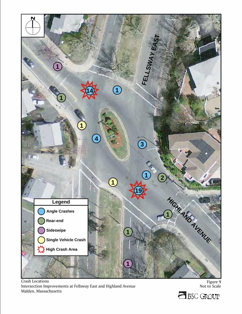
Table 3 shows that during the past five years reviewed (2011 to 2015), an average of 10.4 crashes per year occurred at the intersection. During the most recent three‐year period (2013 to 2015), the number of crashes have increased, with an average of 13 crashes per year. Figure 9 depicts the locations and types of 51 of the 52 crashes occurring over the five years reviewed. The location of one crash involving a tree limb could not be determined from the information provided and is therefore not included in Figure 9.
Fellsway East at Highland Avenue
2011 2012 2013 2014 2015
Crash Severity
Property Damage 8 2 8 6 9
Injury 1 2 1 8 6
Unknown 0 0 1 0 0
Manner of Collision
Rear End 0 1 3 1 0
Angle 7 3 6 12 14
Sideswipe 0 0 1 0 1
Single Vehicle Crash 2 0 0 1 0
Time of Day
6am‐10am 1 1 1 2 5
10am‐4pm 4 2 2 6 3
4pm‐7pm 2 0 3 4 3
7pm‐6am 2 1 4 2 4
Roadway Condition
Dry 6 3 8 12 13
Wet 2 1 1 2 2
Other 1 0 0 0 0
Season
Dec‐Feb 2 1 1 1 4
Mar‐May 4 1 3 4 0
Jun‐Aug 1 0 2 4 5
Sep‐Nov 2 2 4 5 6
Light Condition
Daylight 5 3 6 12 11
Dark (Lit) 3 1 1 2 4
Unknown 1 0 0 0 0
Total 9 4 10 14 15
Avg. No. of Crashes per Year 10.4
FELL
SW
AY
EA
ST
HIGHLAND AVENUE
19
14
34
12
1
1
1
1
1
1
1
1
Not to ScaleIntersection Improvements at Fellsway East and Highland AvenueMalden, Massachusetts
Crash Locations Figure 9
Single Vehicle Crash
Sideswipe
Rear-end
Angle Crashes
High Crash Area
Legend

Fellsway East and Highland Avenue
Malden, Massachusetts July 2016
16
Single vehicle crash6%
Rear‐end9%
Angle81%
Sideswipe4%
Incapacitating4%
Non‐incapacitating
10%
Possible injury21%
No injury65%
BSC then reviewed the crash reports to identify trends in specific data. The following can be identified when analyzing the crash data:
81% (42 crashes) of crashes occurred due to vehicles colliding at an angle.
In 73% (38 crashes) of crashes, the cause was identified by police as “failure to yield.”
45% (19 crashes) of angle crashes occurred at the point of intersection of Fellsway East Northbound and Highland Avenue Southeastbound. 33% (14 crashes) occurred at the point of intersection of Fellsway East Southbound and Highland Avenue Northwestbound.
The majority of crashes (9 total) occurred between 12:00 PM and 1:00 PM. The second most common hour for crashes (7 total) was between 4:00 PM and 5:00 PM.
35% (18 crashes) of crashes at this intersection resulted in personal injuries.
In three crashes, vehicles struck at an angle were then pushed into other vehicles.
69% (16 crashes) of crashes occurred outside the peak periods (7‐9 AM and 4‐6 PM)
42% (22 crashes) of crashes occurred between the months of August and October.
Figures 10 through 15 graphically illustrate the results of the trends in data under various categories of crash specifics (manner of collision, crash severity, light conditions, roadway conditions, time of day, time of year) during the five‐year time period that was reviewed.
Figure 10: Manner of Collision Figure 11: Crash Severity

Fellsway East and Highland Avenue
Malden, Massachusetts July 2016
17
Daylight71%
Darkness27%
Unknown2%
Dry82%
Wet16%
Snow or icy2%
Figure 12: Light Condition Figure 13: Roadway Condition
0123456789
10
Hourly Distribution of Crashes
0123456789
Monthly Distribution of Crashes
Figure 14: Hourly Distribution of Crashes
Figure 15: Monthly Distribution of Crashes

Fellsway East and Highland Avenue
Malden, Massachusetts July 2016
18
The crash rate is another effective tool for examining the relative safety of a particular location. Crash rates were calculated for the intersection using the available crash data and the existing 2016 traffic volumes. The rates represent the number of crashes per million vehicles entering the intersection. The most recent statewide and district average crash rates issued by MassDOT indicate that the statewide average is 0.58 for unsignalized intersections. The MassDOT District 4 average (which include the City of Malden) is 0.56 for unsignalized intersections. These rates represent ‘average’ crash experience and serve as a basis for comparing reported crash rates. Table 4: Calculated Crash Rates
As can be seen in Table 4, the study intersection exhibits a crash rate more than double both the average MassDOT Statewide and District 4 rates. Based on the high percentage of angle crashes (81 percent), BSC believes that the leading causes of crashes at this intersection are: confusion over which vehicles have the right of way and which must yield; high vehicle speeds entering the intersection; and driver aggression after having to wait in long queues and delays. The crash trends do not indicate any extenuating circumstances for the crashes, such as roadway or weather conditions or poor lighting.
Fellsway East at Highland Avenue
2011 2012 2013 2014 2015
Total 9 4 10 14 15
Avg. No. of Crashes per Year 10.4
Calculated Crash Rate a 1.27
Average MassDOT Crash Rate (Statewide / District 4)
0.58 / 0.56
a per million entering vehicles, as defined by the Massachusetts Department of Transportation – Highway Division

Fellsway East and Highland Avenue
Malden, Massachusetts July 2016
19
Chapter 3: Design Alternatives
As discussed in the above sections, the intersection of Fellsway East with Highland Avenue is plagued by several transportation and traffic issues, including: a high number of crashes; lack of sufficient traffic control; wide pavement areas; non‐conformance to standard vehicle right‐of‐way rules; outdated, conflicting, and missing signage; long pedestrian crossings; and high vehicle approach speeds. The intersection also experiences relatively high weekday morning peak hour volumes in one direction on Fellsway East. These issues were the dominating factors taken into consideration when evaluating potential traffic improvement alternative concepts, while keeping in mind the overarching goals of improving traffic operations and increasing safety. The sections below outline various alternative improvement concepts, categorized into short‐term and long‐term improvements. It should be noted that DCR has engaged with another firm to perform a study of the existing and potential future improvements to bicycle amenities along the Fellsway East corridor. The results of this study were not available prior to the completion of this Traffic Study, however any findings from the bicycle study should be incorporated into the final design improvements at the intersection of Fellsway East and Highland Avenue.
3.1 Alternative 1 –Short-Term Modifications
This section discusses various short‐term and relatively low‐cost improvements that could be implemented in order to clarify vehicular right of way, control travel speeds, evaluate regional traffic, and monitor the potential long‐term improvements. The intersection currently operates most closely to a typical roundabout, therefore each of these improvements is intended to modify the intersection operations to act as such. The improvements include installation and replacement of signs, reduction of travel lanes, and improvement/clarification of yield‐control operations to reduce driver confusion. Additional traffic counts are also suggested to fully understand the regional traffic volumes and travel patterns. None of these changes would require permanent physical changes to the roadway geometry. The following improvements should be considered:
Post “Keep Right” signs on the central oval island to ensure that drivers circulate around the island in a counter‐clockwise manner
Install combination speed radar and speed limit signs on Fellsway East to encourage reduced speeds along the roadway
Institute random speed enforcement checks by State Police on Fellsway East and by the Malden Police on Highland Avenue
Use stanchions (or traffic cones/drums or sandbags) to reduce the number of travel lanes on the Fellsway East southbound approach from two to one and on the Fellsway East northbound approach from three to one. This would help to control travel speeds along Fellsway East and reduce the number of conflict points for vehicles entering the

Fellsway East and Highland Avenue
Malden, Massachusetts July 2016
20
intersection. It would also allow for the monitoring of a potential future change to lane assignments that are part of the long‐term alternatives.
Install stanchions (or traffic drums/cones or sandbags) to alter the vehicular paths through the intersection and to create deflection, thereby slowing down vehicles. These deflections may include widening the central oval island, reducing curb corner radii, and/or extending the medians on Fellsway East to reduce the travel path width within the intersection.
Remove and change the posted signs so that the intersection operates with “standard” vehicle right of way rules of the road. These changes would direct drivers to always yield to vehicles already within the circulating area of the intersection:
o Post yield signs on both Fellsway East approaches o Remove the yield signs and pavement markings within the intersection
Install a stop sign and a “No Left Turn” sign for vehicles exiting Sawyer Street onto Fellsway East.
Use a painted traffic island to separate directions of travel on Sawyer Street at Fellsway East. This would slow turning vehicles down. If needed, the painted island could be reinforced with cones or drums. It must be noted that any changes to the existing crosswalk would necessitate the reconstruction of the pedestrian access ramps. This should be done as part of the long‐term modifications.
Perform additional traffic counts along the Lynn Fells Parkway corridor to better understand the impacts of regional traffic in the area.
Install wayfinding signs to the Oak Grove MBTA station and other common area destinations in order to try to divert vehicles away from this location.
Reduce the number of travel lanes on Fellsway East southbound and northbound from two lanes and three lanes respectively to one lane.
o Using cones or drums, close the inside lane (next to median) of Fellsway East northbound from Savin Street to Wiley Street, keeping the center lane open for travel and the outside lane open for parking. Traffic may then be shifted to the left lane using the appropriate taper length per MUTCD.
o On Fellsway East southbound, use cones or drums to close the inside lane (next to median) from East Border Road to approximately 350 feet north of the Highland Avenue intersection. Traffic may then be shifted to the left lane using the appropriate taper length per MUTCD.
o Install traffic signs to indicate lane closures, travel lanes, and parking lanes as appropriate. We also recommend the use of variable message signs to warn drivers of changes to lane configurations.
Figure 16 depicts the improvements outlined above for Alternative 1.

44
45
46
47
4
8
4
9
5
0
5
1
5
2
FELLSWAY EAST
HIGHLAND AVENUE
SAWYER STREET
GLE
NW
OO
D S
TRE
ET
STOP STOP
STOP
ONE WAY
YIELD
YIELD
ON BOTH FELLSWAY EAST APPROACHES:
· INSTALL COMBINATION SPEED RADARAND SPEED LIMIT SIGNS.
· INSTALL IN-ROAD STANCHIONS ORTRAFFIC CONES TO REDUCE THENUMBER OF TRAVEL LANES TO ONE.
· IF APPLICABLE, INSTALL "LANE DROP"SIGNS 500 FEET IN ADVANCE OF LANEREDUCTION.
REMOVE EXISTING YIELD SIGNS ANDMARKINGS WITHIN INTERSECTION (TYP.)
(EXIST.)
(EXIST.)
TRAFFIC CONES (TYP.)
Not to ScaleIntersection Improvements at Fellsway East and Highland AvenueMalden, Massachusetts
Not to ScaleIntersection Improvements at Fellsway East and Highland AvenueMalden, Massachusetts
Proposed Alternative 1 - Short-Term Modifications Figure 16

Fellsway East and Highland Avenue
Malden, Massachusetts July 2016
22
3.2 Alternative 2 –Signalization
This design alternative involves the construction of a traffic signal in order to provide traffic control at the intersection. As noted in the discussion of traffic volume patterns in Section 2.3.1, the Fellsway East southbound traffic volumes during the weekday morning peak period constitute a relatively high percentage of the total weekday daily volumes. During the weekday morning peak hour, a high percentage (386 of 1451, or 27 percent) of vehicles turn left from Fellsway East southbound onto Highland Avenue southeastbound or onto Glenwood Street. However, during the remaining approximately 22 hours of the day, vehicle movements at this location are relatively balanced. These patterns were taken into consideration when evaluating traffic signal phasings and operations.
3.2.1 Signal Warrant Analysis
A traffic signal warrant analysis was conducted in order to justify the signalization of the intersection, utilizing traffic volumes from the collected traffic data. The current Manual on Uniform Traffic Control Devices (MUTCD) contains nine traffic signal warrants, at least one of which must be satisfied, in order to justify the installation or continuous operation of traffic signals at a particular location. Satisfying one or more warrants, however does not necessarily justify the installation or continuous operation of a traffic signal. The traffic signal warrants are:
Warrant 1: Eight‐Hour Vehicular Volume; Warrant 2: Four‐Hour Vehicular Volume Warrant 3: Peak Hour Warrant 4: Pedestrian Volume Warrant 5: School Crossing Warrant 6: Coordinated Signal System Warrant 7: Crash Experience Warrant 8: Roadway Network Warrant 9: Intersection Near a Grade Crossing
Not all warrants were evaluated for the intersection, depending on the applicability and data available. Table 5 below displays which of those warrants which were evaluated were met for the intersection of Highland Avenue with Fellsway East.
Table 5: Warrant AnalysisWarrant Fellsway East / Highland Avenue
Warrant 1 NO
Warrant 2 YES
Warrant 3 YES
Warrant 7 YES
As can be seen from this table, three of the nine traffic signal warrants were met for the intersection. It should be noted that volumes for seven of the eight hours were met under Warrant 1 (Eight Hour Vehicular Volume). Signal warrant analyses worksheets are contained in the Appendix.

Fellsway East and Highland Avenue
Malden, Massachusetts July 2016
23
3.2.2 Signalization Concept
Under this option, a traffic signal would be constructed, including associated pedestrian improvements and landscaping opportunities. The central oval island would be removed and the medians along Fellsway East would be extended further into the intersection. The radii of several intersection corners would be reduced / tightened – these areas could provide additional green space to maintain the parkway characteristics. Fellsway East northbound would reduce from three to two travel lanes, providing a formalized parking lane and the potential for a bicycle lane. Pedestrian amenities would be improved with new ADA/AAB‐compliant wheelchair ramps, shortened crosswalk lengths, and audible accessible countdown pedestrian signals for each of the crossing locations within the signalized intersection. Appropriate signage would be installed to guide drivers to the appropriate travel lanes and regulate vehicular movements. This alternative would require the relocation of the existing utility pole and signage currently located in the central oval island. Based on the traffic volume patterns, BSC is recommending that the Fellsway East southbound left‐turn lane operate as a combined left‐through lane, with a permitted left‐turn movement; during the weekday morning peak hours, this movement would essentially operate as a left‐turn only lane, while the rest of the day it would be able to operate as an additional through lane. As additional considerations under this and any other improvements, the conceptual design plan shows both the Glenwood Street and Sawyer Street approaches as realigned in order to allow vehicles to approach the intersection at 90‐degree angles and improve driver sight lines. These approaches would operate under stop‐control just outside of the intersection. Survey would be required in order to determine the feasibility of making these improvements, especially for the Glenwood Street approach, as the existing roadway grades are steep at its intersection with Highland Avenue. Figure 17 depicts the proposed improvements under Alternative 2.

44
45
46
47
4
8
4
9
5
0
5
1
5
2
FELLSWAY EAST
HIGHLAND AVENUE
SAWYER STREET
GLE
NW
OO
D S
TRE
ET
Not to ScaleIntersection Improvements at Fellsway East and Highland AvenueMalden, Massachusetts
Not to ScaleIntersection Improvements at Fellsway East and Highland AvenueMalden, Massachusetts
Proposed Alternative 2 - Signalization Figure 17

Fellsway East and Highland Avenue
Malden, Massachusetts July 2016
25
3.3 Alternative 3 – Roundabout
This alternative would involve modifying the existing intersection geometry to develop a roundabout. While the existing intersection design acts as a circular intersection, it does not meet several of the guiding principles of roundabout design in the United States. According to NCHRP, modern roundabouts feature yield control to all vehicles entering the intersection, channelized approaches, and geometric curvature and features to induce desirable vehicular speeds. The existing intersection features stop‐control on the Highland Avenue approaches, yield control in the middle of the circle, and allows for unrestricted, free‐flow movements for through‐moving vehicles on Fellsway East. The existing geometric design of the intersection provides opportunities for nearly tangential vehicular paths, which allows vehicles to enter the intersection at high speeds and does little for conspicuity of potential vehicular conflicts. Aside from increased conformity to driver expectancy, developing a roundabout can provide substantial safety benefits through the promotion of a low‐speed environment and a reduction in vehicular conflicts. Identified as one of the Federal Highway Administration’s (FHWA) nine proven safety countermeasures, a properly‐designed roundabout can promote the safe flow of vehicles and reduce the frequency and severity of crashes compared to a signalized intersection. A roundabout at this location would also help promote pedestrian safety, as potential roundabout designs will reduce the number of travel lanes that pedestrians are required to cross. Three roundabout conceptual designs were evaluated. Alternative 3A for a single‐lane roundabout features a single‐lane on each approach and exit, as well as a single circulatory lane. Alternative 3B features a second general use southbound lane to help accommodate for heavy southbound through volumes in the weekday morning peak hour. Under Alternative 3C, the additional southbound lane is for left turns only onto Highland Avenue and Glenwood Street. All designs fit within the existing roadway, while modifying the central island design to more effectively direct vehicles through the intersection. As aforementioned, all of the pedestrian crossing distances are reduced through the reduction in travel lanes at the intersection. Under Alternative 3C, a single multi‐lane crossing would remain on the Fellsway East southbound approach; however, the installation of a raised crosswalk at this location may aid driver perception and further reduce vehicle speeds on the approach. Under Alternative 3B, two multi‐lane pedestrian crossings would be located on the Fellsway East southbound entering and exiting legs; the multi‐lane pedestrian crossing particularly on the departure leg is a particular safety concern and would potentially require the installation of some type of signal, warning beacon, or pavement treatment. As the designs shown reduce the overall paved area within the intersection, the roundabout also provides greater opportunities for landscaping and aesthetic improvements to the roadside and central island. Figure 18 depicts the improvements proposed under Alternative 3C, showing the conceptual design for the proposed exclusive left‐turn southbound lane roundabout. A sketch‐level design for the single‐lane and two‐lane (Alternatives 3A and 3B, respectively) are included in the Appendix.

44
45
46
47
4
8
4
9
5
0
5
1
5
2
ON
LY
O
NLY
FELLSWAY EAST
HIGHLAND AVENUE
SAWYER STREET
GLE
NW
OO
D S
TRE
ET
Not to ScaleIntersection Improvements at Fellsway East and Highland AvenueMalden, Massachusetts
Not to ScaleIntersection Improvements at Fellsway East and Highland AvenueMalden, Massachusetts
Proposed Alternative 3C - Roundabout (Southbound Left-Turn Lane) Figure 18

Fellsway East and Highland Avenue
Malden, Massachusetts July 2016
27
Chapter 4: Analysis of Alternatives
4.1 Future Traffic Volumes
Measuring existing traffic volumes and projecting future traffic volumes quantifies traffic flow within a study area. To assess quality of flow, a capacity analysis was conducted at the study intersection for Existing and Future conditions. The Future Condition scenario was evaluated under a ten‐year planning horizon (to 2026), in order to evaluate mid‐term traffic impacts. Traffic volumes for the 2026 Future Condition were calculated by applying a background growth rate to the 2016 Existing Condition traffic volumes.
Discussions with the Central Transportation Planning Staff (CTPS) indicated that their projected annual growth rate for the City of Malden as a whole is 0.06 percent, while the projected annual growth rate for the intersection of Fellsway East at Highland Avenue, in particular, is 0.03 percent out to the year 2035. In order to provide a conservative assessment, BSC has applied a growth rate of 0.25 percent, compounded per year over the ten year planning horizon. Figures 19 and 20 show the 2026 Future Condition traffic volumes.
4.2 Capacity Analyses Methodology
Capacity analyses provide a standardized indication of the ability of the intersection to accommodate traffic demands placed upon it. A primary result of capacity analyses is the assignment of Levels of Service (LOS) to traffic facilities under various traffic flow conditions. Analyses were conducted using methods defined in the Highway Capacity Manual 2010 (TRB, 2010) for unsignalized intersections. The concept of Level of Service is defined as a qualitative measure describing operational conditions within a traffic stream and their perception by motorists.
A Level of Service definition generally describes these conditions in terms of such factors as speed and travel time, freedom to maneuver, traffic interruptions, comfort and convenience, and safety. In so doing, Level of Service provides an index to quality of traffic flow.
Six Levels of Service are defined for each type of facility. They are given letter designations, from A to F, with LOS A representing the best operating conditions and LOS F representing the worst. Since the Level of Service of a traffic facility is a function of traffic flows placed upon it, an intersection may operate at a wide range of Levels of Service, depending on time of day, day of week, or period of year.
The average delay per vehicle approaching an intersection is used to quantify the Level of Service at a particular intersection. This is discussed briefly below, and LOS designations are defined in Table 6. Average delay measures the mean stopped delay experienced by vehicles entering an intersection during the design period. Average delay is measured for each individual turning movement that must yield the right of way, including through vehicles that experience no delay.


Fellsway East and Highland Avenue
Malden, Massachusetts July 2016
30
Table 6: Level of Service Designations
Category Unsignalized / Roundabout Delay
(sec/veh) Signalized Delay
(sec/veh)
LOS A 0.0 – 10.0 0.0 – 10.0
LOS B 10.1 – 15.0 10.1 – 20.0
LOS C 15.1 – 25.0 20.1 – 35.0
LOS D 25.1 – 35.0 35.1 – 55.0
LOS E 35.1 – 50.0 55.1 – 80.0
LOS F 50.1 + 80.1+
Source: Transportation Research Board, Highway Capacity Manual, National Research Council, 2010.
The results of the capacity analysis for the intersections evaluated are summarized below. The Synchro traffic analysis software package (Version 9) was employed to evaluate operating conditions for the existing intersection and the proposed traffic signal alternative. This software uses methodology based on the Highway Capacity Manual (2010 edition) to conduct the analyses, and is accepted for use by the Massachusetts Department of Transportation (MassDOT).
The FHWA recently commissioned a study (TOPR 34) to collect new U.S. roundabout capacity data to update the capacity equations contained in the Highway Capacity Manual 2010. The project collected video data from 23 roundabouts in six states, for a total of 1,100 hours of data. Ultimately, the single‐lane roundabout capacity models were developed using 876 minutes of roundabout data, which is more than twice the amount of data used to develop the HCM 2010 models. The FHWA TOPR 34 project report has yet to be published; however, the field data collection has concluded, and new capacity models have been developed based upon the field‐observed data. The new TOPR 34 capacity models were adopted in June 2015 by the Transportation Research Board Committee on Highway Capacity and Quality of Service for inclusion in a major update to the Highway Capacity Manual expected to be released in late 2015/early 2016. The analysis performed by KAI uses the TOPR 34 model through the SIDRA INTERSECTION (Version 6) software.
Table 7 provides the results of the capacity analysis for the existing conditions, as well as the future design alternatives (traffic signal installation and roundabout implementation) using current 2016 traffic volumes during the weekday morning and afternoon peak hours. Capacity analyses were also performed for the proposed signal and roundabout alternatives using the 2026 Future Condition traffic volumes, shown in Table 8.
The tables provide both the average and 95th percentile (or maximum) queue lengths. Intersection capacity analysis worksheets are contained in the Appendix.
Note that the thresholds for each Level of Service category are not the same when comparing unsignalized and roundabout intersections versus signalized intersections. Therefore, in order to make adequate comparisons, it is recommended to compare total seconds per vehicle of delay and not Levels of Service. For completeness, the results of the capacity analyses presented below show both delay and LOS.

Fellsway East and Highland Avenue
Malden, Massachusetts July 2016
31
4.3 Capacity Analyses Under Existing Conditions
Table 7: Level of Service Summary – 2016 Existing Condition Volumes
Existing Alternative 2 ‐ Signalization Alternative 3A ‐ Roundabout
(Single Lane) Alternative 3B ‐ Roundabout
(Two Lane SB)
Alternative 3C ‐ Roundabout (Exclusive SB
Left )
Ave. Delay (sec)
LOS Queue (max) (ft)
Ave. Delay (sec)
LOS Queue (avg / max) (ft)
Ave. Delay (sec)
LOS Queue (avg / max) (ft)
Ave. Delay (sec)
LOS Queue (avg / max) (ft)
Ave. Delay (sec)
LOS Queue (avg /
max) (ft)
WEEKDAY MORNING PEAK HOUR
Fellsway East NB LTR 11.0 B 8 52.7 D 62/84 6.7 A 12/29 7.6 A 13/31 7.8 A 13/32
Fellsway East SB L or LT 11.8 B 55 ‐ ‐ ‐ ‐ ‐ ‐ 23.9 C 110/272 9.5 A 25/62
Fellsway East SB LTR or TR 0.0 A 0 51.7 D 525/697 >120.0 F 1,964/4,8821 23.9 C 110/272 120.0 F 758/1,8841
Highland Ave SEB LTR >120.0 F 9552 26.3 C 232/354 75.2 F 184/457 >120.0 F 4550/1,138 >120.0 F 295/733
Highland Ave NWB LTR >120.0 F 5302 73.7 E 355/556 7.1 A 25/61 7.1 A 25/61 7.1 A 25/61
Overall * * 51.0 D >120.0 F 51.3 F 74.6 F
WEEKDAY AFTERNOON PEAK HOUR
Fellsway East NB LTR 7.8 A 10 19.8 B 102/253 30.2 D 128/319 29.7 D 128/315 14.0 B 49/121
Fellsway East SB L or LT 11.1 B 8 ‐ ‐ ‐ ‐ ‐ ‐ 7.5 A 10/26 6.6 A 9/22
Fellsway East SB LTR or TR 0.0 A 0 9.1 A 23/61 7.7 A 11/28 7.5 A 10/26 6.6 A 9/22
Highland Ave SEB LTR >120.0 F 5553 12.9 B 145/235 8.9 A 32/80 8.0 A 25/63 8.0 A 26/64
Highland Ave NWB LTR >120.0 F 4953 13.2 B 151/250 21.9 C 73/183 21.7 C 73/181 15.6 C 49/123
Overall * * 14.9 B 20.1 C 19.5 C 11.6 B
1Distance Between Fellsway East @ East Border Road and Fellsway East @ Highland Avenue = 1,350 feet.
2Field observations indicate the following queues during the morning peak hour: Highland Avenue SEB: 25+ cars (625+ ft), Highland Avenue NWB: 10 cars (250 ft)
3Field observations indicate the following queues during the afternoon peak hour: Highland Avenue SEB: 15 cars (375 ft), Highland Avenue NWB: 13 cars (325 ft)
*HCM does not provide overall intersection delay/LOS for unsignalized intersections.
Abbreviations: NB = Northbound, SB = Southbound, SEB = Southeastbound, NWB = Northwestbound, L = Left, T = Through, R = Right

Fellsway East and Highland Avenue
Malden, Massachusetts July 2016
32
Table 7 shows that under existing conditions during both the weekday morning and afternoon peak hours, both Highland Avenue approaches operate at failing levels of service, with delays greater than 120 seconds and queues extending approximately 500 feet and up to nearly 1,000 feet. Field observations indicated that, during the weekday morning peak hour, the Highland Avenue southeastbound approach experienced queues greater than 25 cars (or 625 feet) long. During the weekday afternoon peak hour, vehicles queues on Highland Avenue northwestbound were observed to be approximately 13 cars (or 325 feet) long.
As discussed in Section 3.3, three roundabout alternatives were evaluated, particularly during the critical weekday morning peak hours. A single lane roundabout was analyzed and, as can be seen from Table 7, resulted in calculated delays greater than 120 seconds on the Fellsway East southbound approach, with average queues of approximately 2,000 feet and maximum queues extending approximately 4,800 feet, well beyond East Border Road. The next roundabout design alternative, involving two general use approach lanes and two departure lanes on Fellsway East southbound, resulted in improved operations on Fellsway East. However, Table 7 shows that this alternative resulted in high delays and long queues for the Highland Avenue southeastbound approach. The third and final roundabout alternative which was considered involved two approach lanes on Fellsway East southbound, one of which is an exclusive left‐turn lane onto Highland Avenue (and subsequently Glenwood Street). This alternative provides increased capacity on the Fellway East southbound approach but, because only one lane continues southbound on Fellsway East, still allows for Highland Avenue vehicles to enter the roundabout. Using 2016 Existing Condition traffic volumes, this alternative results in more balanced queues on the Fellsway East southbound and Highland Avenue southeastbound approaches, while the expected delays for both are around two minutes.
4.4 Capacity Analyses Under Future Conditions
Table 8: Level of Service Summary – 2026 Future Condition Volumes
Alternative 2 ‐ Signalization Alternative 3A ‐ Roundabout
(Single Lane) Alternative 3C ‐ Roundabout
(Exclusive SB Left )
Ave. Delay (sec)
LOS Queue
(avg/max) (ft)
Ave. Delay (sec)
LOS Queue
(avg/max) (ft)
Ave. Delay (sec)
LOS Queue
(avg/max) (ft)
WEEKDAY MORNING PEAK HOUR
Fellsway East NB LTR 53.2 D 63/85 6.7 A 12/29 8.0 A 13/33
Fellsway East SB L or LT ‐ ‐ ‐ ‐ ‐ ‐ 9.9 A 27/67
Fellsway East SB LTR or TR 57.4 E 537/711 >120.0 F 2,109/5,2411 >120.0 F 864/2,1471
Highland Ave SEB LTR 28.1 C 248/376 80.3 F 205/510 >120.0 F 335/833
Highland Ave NWB LTR 109.9 F 390/593 7.3 A 26/64 7.3 A 26/64
Overall 61.0 E >120.0 F 84.1 F
WEEKDAY AFTERNOON PEAK HOUR
Fellsway East NB LTR 20.0 C 111/255 34.7 D 149/371 14.9 B 53/131
Fellsway East SB L or LT ‐ ‐ ‐ ‐ ‐ ‐ 6.8 A 9/23
Fellsway East SB LTR or TR 9.3 A 25/61 7.9 A 12/29 6.8 A 9/23
Highland Ave SEB LTR 13.5 B 156/251 9.2 A 34/84 8.2 A 27/67
Highland Ave NWB LTR 13.9 B 164/272 24.3 C 149/202 16.7 C 53/133
Overall 15.5 B 22.4 C 12.3 B
1Distance Between Fellsway East @ East Border Road and Fellsway East @ Highland Avenue = 1,350 feet.
Abbreviations: NB = Northbound, SB = Southbound, SEB = Southeastbound, NWB = Northwestbound, L = Left, T = Through, R = Right

Fellsway East and Highland Avenue
Malden, Massachusetts July 2016
33
To fully assess and compare between the alternatives, capacity analyses were performed for the signalization and two roundabout (single lane and southbound left‐turn lane) alternatives, using 2026 Future Condition traffic volumes. The results of this analyses are shown in Table 8. Due to the poor operations on the Highland Avenue southeastbound approach during the weekday morning peak hour, Alternative 3B was not considered when evaluating the alternatives under future conditions.
Table 8 shows that, during the weekday morning peak hour, under signalization, the Fellsway East southbound approach is expected to experience 57 seconds of delay with approximately 540 feet of average queue and 700 feet of maximum queue. During this same time period, the Fellsway East southbound approach would experience delays greater than two minutes under both roundabout alternatives. The anticipated maximum queues would be approximately 5,000 and 2,000 feet for the single lane and southbound left‐turn lane alternative, respectively, while the average queues would be expected to measure approximately 2,000 feet and 900 feet, respectively. During the weekday morning peak hour, the critical Highland Avenue southeastbound approach would experience delays of approximately 28 seconds under the signalized alternative and approximately 80 seconds and greater than 2 minutes under each of the roundabout alternatives.
During the weekday afternoon peak hour, all approaches are generally operating at acceptable levels of service, with expected delays no longer than approximately 35 seconds on any approach and maximum queues less than 400 feet. During this time period, the overall intersection delay is expected to be approximately 16 seconds under the signalization alternative, approximately 22 seconds under the single lane roundabout alternative, and approximately 12 seconds under the southbound left‐turn lane roundabout alternative.
4.5 Comparison of Alternatives
Using Future Condition traffic volumes during the weekday morning peak hour, Alternative 2 (signalization) is expected to have the least delay on the Fellsway East southbound approach. This alternative would also experience the least delay for the overall intersection. However during this time period, queues on the Highland Avenue northwestbound approach are the shortest under the two roundabout alternatives, thereby reducing blockages on the Highland Avenue northwestbound approach for vehicles exiting Glenwood Street.
During the weekday afternoon peak hour, the critical approaches are the Fellsway East northbound and Highland Avenue southeastbound approaches. These movements are expected to experience the least delays under Alternative 3C (southbound left‐turn roundabout). Alternative 3C is also expected to have the least overall intersection delay.

Fellsway East and Highland Avenue
Malden, Massachusetts July 2016
34
Chapter 5: Cost Analysis
Conceptual‐level cost estimates have been calculated for each of the alternatives in order to provide a point of comparison.
The following assumptions have been made regarding the cost estimates for both the signalization and roundabout alternatives:
Cold plane and overlay within the intersection and along approximately 50 feet of each approach on Fellsway East and Highland Avenue.
The limits of the design would not include any improvements on Glenwood Street or Sawyer Street.
New sidewalks and wheelchair ramps, where necessary, based on the reduced pavement areas and intersection geometry improvements
The estimates do not include assumptions regarding utility (drainage, sewer, water, etc) modifications or traffic management, but contingencies have been applied to both estimates cover these and other potential unknown costs.
The following assumptions have been made for the signalization concept ONLY:
Remove the central oval island and apply full depth pavement reconstruction Extend the existing median islands on Fellsway East Construct mast arms and traffic signal posts, and install a traffic signal control cabinet Upgrade and provide all necessary pedestrian improvements, including new sidewalks,
ADA/AAB compliant wheelchair ramps, countdown pedestrian heads, and audible accessible push buttons.
The following assumptions have been made for the roundabout concept ONLY:
Reconstruct the central oval island to provide a more circular travel path for vehicles. The center island provides potential landscaping opportunities, while a truck apron provides accommodation for buses and trucks on Highland Avenue.
Additional landscaping costs for the central island.
Based on the above assumptions, Table 9 compares the approximate estimated costs for constructing each of the proposed alternatives at the intersection of Fellsway East and Highland Avenue. An estimate of the approximate cost has been prepared for the proposed two‐lane roundabout only. The costs for the single lane or the exclusive left‐turn lane variations are assumed to be similar. Breakdowns of the cost estimates for the signalization and roundabout alternatives are included in the Appendix.
Table 9: Conceptual Level Cost Estimates
Alternative Estimated Approximate Cost
1 – Operational Improvements $40,000
2 – Signalization $610,000
3 – Roundabout (Southbound Left‐Turn Lane) $330,000

Fellsway East and Highland Avenue
Malden, Massachusetts July 2016
35
Chapter 6: Conclusions and Recommendations
The BSC Group and Kittelson & Associates, Inc. team have prepared this Traffic Study for the intersection of Fellsway East and Highland Avenue in Malden, Massachusetts. The goals of this study were to evaluate existing safety and operational deficiencies and provide design concepts to improve vehicular operations and increase safety at the intersection. This study has reviewed the existing conditions at the intersection, identified the existing deficiencies, and evaluated potential improvement options.
This traffic study has determined the following:
The intersection is plagued by many operational and safety issues, including but not limited to a lack of sufficient traffic control; wide pavement areas; non‐conformance to standard vehicle right‐of‐way rules of the road; high speeds; and long queues and delays during the peak hours.
The traffic volumes during the weekday morning peak hours constitute a relatively large percentage of the total daily volumes. During this time, volumes on the Fellsway East southbound approach are 22 percent of the total daily traffic volumes in that same direction.
The 85th percentile vehicle speeds on Fellsway East range from 41 MPH to 47 MPH, while the posted speed limit on this road is 25 MPH in the northbound direction and 30 MPH in the southbound direction. Field observations indicated that vehicles traveling along Fellsway East seldom slowed down as they traveled through the intersection since they are not under any traffic control.
The weekday morning and afternoon peak hours were determined to be 7:30 to 8:30 AM and 4:45 to 5:45 PM, respectively. During these times, long queues and delays were observed on many of the approaches.
During the past five years reviewed (2011 to 2015), an average of 10.4 crashes per year occurred at the intersection. During the most recent three year period (2013 to 2015), the number of crashes have increased, with an average of 13 crashes per year.
Based on the high percentage of angle crashes (81 percent), BSC believes that the leading causes of crashes at this intersection are: confusion over which vehicles have the right of way and which must yield; high vehicle speeds entering the intersection; and driver aggression after having to wait in long queues and delays.
Based on the above results, several design alternatives have been developed in order to improve operations and increase safety. These alternatives are briefly summarized below:
Alternative 1 – Operational Improvements: This alternative includes various short‐term and relatively low‐cost improvements that could be implemented quickly in order to clarify vehicular right of way, control travel speeds, and test the potential long‐term improvements. The intersection currently operates most closely to a typical roundabout,

Fellsway East and Highland Avenue
Malden, Massachusetts July 2016
36
therefore each of these improvements is intended to modify the intersection operations to act as such. The improvements include installation and replacement of signs, reduction of travel lanes, and improvement/clarification of yield‐control operations to reduce driver confusion. None of these changes would require permanent physical changes to the roadway geometry.
Alternative 2 – Signalization: This design alternative involves the construction of a traffic signal in order to provide traffic control at the intersection. The design would include the construction of a traffic signal, including associated pedestrian improvements and landscaping opportunities. In association with considering this alternative, a traffic signal warrant analysis was performed and resulted in three of the nine MUTCD warrants being met, therefore justifying the installation of a signal.
Alternative 3 – Roundabout: Under this alternative, three variations were considered, each requiring different roundabout designs and providing intersection capacity improvements to varying degrees. The preferred alternative would involve the construction of a single lane roundabout with two approach lanes on Fellsway East southbound, one of which is an exclusive left‐turn lane onto Highland Avenue southeastbound and Glenwood Street.
Capacity analyses were performed for the existing intersection layout and for all of the proposed alternatives utilizing 2016 Existing Condition traffic volumes. Capacity analyses were also performed using 2026 Future Condition traffic volumes for the proposed signalization alternative, as well as for the single lane and southbound left‐turn lane roundabout options. The delay and queue impacts to the Highland Avenue approach were considered too great during the weekday morning peak hour under the two‐lane southbound approach roundabout to consider for review under Future Conditions. The results of the capacity analyses using 2026 Future Conditions traffic volumes indicated that the overall intersection delays are lowest under Alternative 3C, which analyzed a roundabout with an exclusive left‐turn lane on the Fellsway East southbound approach.
Order of magnitude cost estimates were prepared for each of the design alternatives. It is estimated that the Alternative 1 short‐term improvements would cost approximately $40,000 to implement, while the long‐term signalization or roundabout alternatives would cost approximately $610,000 and $330,000, respectively. The cost estimates were calculated based on broad‐scope assumptions and, while they include contingencies for certain unknowns, do not take into consideration specific elements that may come up during a complete design process.
Given the aforementioned goals of the study – to improve vehicular operations and increase safety at the intersection – the following factors were taken into consideration when evaluating each of the alternatives:
Delays and queues on the critical movements of the intersection during the peak periods.
Delays for the overall intersection
Improvements to pedestrian accommodations, including shortened crossing distances
Reduction in approach speeds, particularly along Fellsway East
Cost of construction/implementation, including long‐term maintenance
The existing characteristic of the intersection, which most closely resembles a roundabout
Based on the above factors, we recommend Alternative 3C (exclusive southbound left‐turn lane roundabout) be further considered as the long‐term design improvement at the intersection.

Fellsway East and Highland Avenue
Malden, Massachusetts July 2016
37
In conclusion, it is the opinion of BSC Group and Kittelson & Associates, Inc. that there are a variety of short‐term improvements can be made almost immediately and with relatively low cost. Each of the long‐term improvements suggested in this report would require further engineering design and analysis in order to be fully implemented, such as field survey, utility design and relocation, and consideration of bicycle accommodations. In summary, this Traffic Study has documented the existing conditions and has evaluated several design alternatives for the consideration of DCR at the intersection of Fellsway East and Highland Avenue in Malden, Massachusetts.