traffic control devices manual - part 2
TRANSCRIPT

Traffic control devices manual
Part 2 Direction, service and general guide signs
© NZ Transport Agency
www.nzta.govt.nz
First edition
Effective from January 2011
ISBN 978-0-478-37177-2 (online)
This document ceases to be a controlled document when printed. Please refer to the current version on www.nzta.govt.nz.

Traffic control devices manual part 2: Direction, service and general guide signs Page i
First edition Effective from January 2011
Contents
1.0 Introduction 1-1
1.1 Purpose 1-1
1.2 Scope 1-1
1.3 Engineering judgement 1-2
1.4 Sign schemes 1-3
1.5 Value for money 1-3
2.0 Responsibilities 2-1
2.1 Road controlling authorities 2-1
2.2 Road users 2-2
3.0 Legal framework and implications 3-1
3.1 Legislation 3-1
3.2 Obligations to install signs 3-3
3.3 Enforcement 3-3
4.0 Route and guide signs 4-1
4.1 Principles and applications 4-1
4.2 Route and guide sign strategies and policies 4-2
4.3 Route types 4-3
4.4 Route and guide sign layout and details 4-6
4.5 Forms of route and guide signs 4-9
4.6 Route indicator symbols and signs 4-9
4.7 Advance information signs 4-13
4.8 Advance direction 4-14
4.9 Advance lane designation signs 4-20
4.10 Route begins signs 4-25

Traffic control devices manual part 2: Direction, service and general guide signs Page ii
First edition Effective from January 2011
4.11 Intersection direction signs 4-26
4.12 Confirmation direction signs 4-29
4.13 Destination signs 4-32
4.14 Route ends signs 4-33
4.15 Special vehicle guide signs 4-34
5.0 Service signs 5-1
5.1 Principles and application 5-1
5.2 Forms of services signs 5-1
5.3 Service sign layout and details 5-2
5.4 Information services 5-9
5.5 Rest areas 5-10
5.6 Commercial services 5-12
5.7 Accommodation services 5-14
5.8 Other services 5-16
5.9 Services in bypassed communities 5-18
6.0 Tourist signs 6-1
6.1 Principles and application 6-1
6.2 Tourist sign strategies and policies 6-2
6.3 Forms of tourist signs 6-3
6.4 Tourist sign layout and details 6-3
6.5 Eligibility for tourist signing 6-5
6.6 Tourist facilities 6-7
7.0 Street name signs 7-1
7.1 Principles and application 7-1
7.2 Design 7-1
7.3 Location 7-7

Traffic control devices manual part 2: Direction, service and general guide signs Page iii
First Edition Effective from January 2011
8.0 General interest signs 8-1
8.1 Principles and application 8-1
8.2 Forms of general interest signs 8-2
8.3 General interest sign layout and details 8-2
8.4 Public amenities and community facilities 8-4
8.5 Land features 8-5
8.6 Route position and referencing systems 8-6
Appendix A Dual names 1
Appendix B Typical guide sign layouts 1
Appendix C Typical layouts for service signs 1
Appendix D Example layouts for tourist signs 1

Traffic control devices manual part 2: Direction, service and general guide signs Page iv
First edition Effective from January 2011
Preface
Introduction
The NZ Transport Agency’s Traffic control devices manual (TCD manual) will provide guidance on industry good practice, including, where necessary, practice mandated by law. The planned structure of the TCD manual comprises 10 parts as shown in table A.
Each part will be developed under the guidance of a working group of practitioners experienced in, and having specific knowledge about, the subject. The practitioners will also be representative of the intended users of the documents. Interested practitioners and affected organisations will be given the opportunity to comment on drafts and have their input incorporated appropriately in the final document.
The TCD manual will be published electronically only and will be available on the NZ Transport Agency’s website.
Relationship with other documents
The TCD manual will support and reference:
• New Zealand legislation and, in particular, the Land Transport Act 1998 and rules made pursuant to that act, including the Land Transport (Road User) Rule, the Land Transport Rule: Traffic Control Devices 2004 and the Land Transport Rule: Setting of Speed Limits 2003
• general policies contained in Austroads guides (in particular, the guides to traffic management, road design and road safety) by providing detailed guidance to meet specific requirements of New Zealand law and practices
• New Zealand and, as appropriate, Australian standards • codes of practice, guidelines and published standards of various authorities.
Each part will attempt to provide a broad coverage of the subject but avoid duplicating major elements of referenced documents, preferring to direct readers to the source.
The TCD manual will, on completion, replace the joint Transit New Zealand and Land Transport NZ publication Manual of traffic signs and markings (MOTSAM).
Part 2 Direction, service and general guide signs
Part 2 was developed with guidance from a working group representing local government (two members), Road Safety Manufacturers Association (two members) and the NZ Transport Agency (two members from Highway Network operations and one member from Network Standards and Safety). They were assisted by the contracted authors (Cherie Urlich, Tim Selby, Keith Moyes and Grant Gordon) from Opus International Consultants.

Traffic control devices manual part 2: Direction, service and general guide signs Page v
First edition Effective from January 2011
Table A Planned structure of the TCD manual
Part Title Outline of content – may vary as the manual develops
Sign specifications Detailed descriptions of traffic signs including dimensions, colour and layout
Signal specification Detailed descriptions of permitted traffic signal displays and dimensions and colours of signal aspects
Marking specification Detailed description of road markings, including dimensions, colours and layout
1 General requirements for traffic signs Purposes of traffic signs and their legal foundation
Materials and construction
General design principles – size, lettering, legends
Installation – location, mounting heights, etc
2 Direction, service and general guide signs
Route signing, including state highways, regional roads, bypasses, detours, scenic routes
Street name signing, including design and location
Services signing policy, application and design
Tourist signing
General information signs, eg public amenities, features
3 Advertising signs Design and location principles
Policies for billboards and other forms of roadside advertising
4 Traffic control devices for general use – at intersections
Treatments at intersections, including options for traffic control, advance warning, etc
5 Traffic control devices for general use – sections of road
Treatments between intersections, including delineation, curves, passing facilities, steep grades, etc
6 Speed management Safe system approach to speed
Signs and markings for speed limits
Temporary and variable speed limits
Local area traffic management
7 Parking controls (formerly part 13) Legal framework – implications and responsibilities
Design considerations and elements
Linear and zone parking treatments
Parking furniture, eg meters, vending machines
8 Temporary traffic management Code of practice for temporary traffic management and local body supplement
9 Level crossings Risk assessment (ALCAM)
Design considerations, eg facility types, traffic movements, stacking distance, sight distances
Types of control – passive or active
10 Motorways and expressways Specific signing and marking requirements for motorways and expressways
Definitions Definitions of terms used throughout the TCD manual
References All documents referenced throughout the TCD manual

Traffic control devices manual part 2: Direction, service and general guide signs Page vi
First edition Effective from January 2011
Record of amendments
Amendment number
Description of change Effective date Updated by

Traffic control devices manual part 2: Direction, service and general guide signs Page 1-1
First edition Effective from January 2011
1.0 Introduction
1.1 Purpose
What’s in this document
Part 2 Direction, service and general guide signs, is part of a suite of guidelines within the Traffic control devices manual (TCD manual) prepared by the NZ Transport Agency (the NZTA or the Agency). The document is intended to help provide guidance and indicate best practice guidance on the use of traffic signs related to guiding road users around the road network. In particular, it builds upon the specifications for approved signs for use in New Zealand as set down in the Traffic control devices specifications (TCD specifications).
Terminology – law or good practice
This document outlines the legal framework and responsibilities for the design and installation of traffic signs, including the general principles behind their use at the time the document has been drafted. It should not be used in substitution for professional advice as to compliance with relevant central and local government requirements.
The following terminology is used within the document to determine whether an aspect or statement made is a requirement under law or good practice. These terms are:
• must – indicates something that is mandatory or required by law • should – indicates a recommendation • may – indicates something that is optional and may be considered for use.
1.2 Scope
The document seeks to incorporate links to a number of appropriate policies, standards and guidelines and forms a logical link to New Zealand practices for the Austroads Guide to traffic management. It should be read in conjunction with:
• legislative requirements, particularly the Land Transport Rule: Traffic Control Devices 2004 (TCD Rule) and the Land Transport (Road User) Rule 2004 (Road User Rule)
• New Zealand and Australian standards, particularly Australian Standard 1744 Standard alphabets for traffic signs (AS1744:1975), Australian/New Zealand Standard 1906.1 Retro-reflective materials and devices for traffic control purposes (AS/NZS 1906.1:2007) and Australian Standard 1742.15-2007 Manual of uniform traffic devices, part 15 Direction signs, information signs and route numbering
• guidelines, particularly the Austroads Guide to traffic management, in particular part 10 Traffic control and communication devices.
Where direction and route signs relate to specific types of roads users, relevant comment has been included and reference made to other parts of the TCD manual as appropriate.

Traffic control devices manual part 2: Direction, service and general guide signs Page 1-2
First edition Effective from January 2011
The document is intended to provide guidance to traffic and transport practitioners on the use of traffic signs related to:
• route and guide signs • service signs • tourist signs • street name signs, and • general interest signs (subset of general information signs).
Route and guide signs
Route and guide signs inform road users about directions and distances to destinations. Information on the different types of signs that can be used for this purpose is contained in section 4.
Service signs Service signs are advisory signs used to indicate facilities commonly required by travellers. The facilities are located adjacent to the road, a short distance ahead or a reasonable distance along a side road and can generally be identified by an approved symbol. These facilities include rest areas, certain commercial services, accommodation, information and include services such as toilets, airports, medical centres. The service signs were previously termed ‘motorist service signs’ in existing New Zealand documents. Information on the different types of service signs is contained in section 5.
Tourist signs Tourist signs are signs used to advise of tourist facilities and tourist ways to those touring and visiting road users unfamiliar with the area being travelled through. Although tourist signs generally do not guide road users through the road network in the same manner as route and guide signs they, along with service signs, form part of the overall traffic sign system working in conjunction with direction and route signs. Information on the different types of tourist signs is contained in section 6.
Street name signs Street name signs are used at intersections to provide guidance to all road users. They can provide critical confirmation to users they are on the correct route and therefore have a distinct role within the sign system. Information on street name signs is contained in section 7.
General interest signs
General interest signs are advisory signs used to provide road users with information relating to the location of a range of local services and facilities or provide guidance and information relating to a specific location of interest. Information on general interest signs is contained in section 8.
1.3 Engineering judgement
This document provides rules, standards and guidance on the use of traffic signs. However, practitioners should always apply sound engineering judgement in the use and installation of traffic signs to ensure they will be effective at any particular site, For instance, the geometry at a site may require some modification to the sign face to clearly convey an important message such as the shape of the road, or the sign may have to be installed at a more appropriate location. In such instances, engineering judgement must be applied and any departures from recommended practice documented.

Traffic control devices manual part 2: Direction, service and general guide signs Page 1-3
First Edition Effective from January 2011
1.4 Sign schemes
When determining appropriate route, guide, service, tourist and general information signs for a national, regional or local network it is important to develop sign schemes that provide a consistent message to those using the road network.
Sign and marking schemes are necessary to ensure:
• overall and individual proposals are logical and consistent in the way information is presented to road users
• there is coordination with other devices and features (ie traffic signals, street lighting)
• a logical progression through the system exists for all road users • they conform to the national or local sign strategy.
Austroads Guide to traffic management part 10 has detailed information on sign and marking schemes, and should be accessed for further guidance.
1.5 Value for money
The Land Transport Management Act 2003 (LTMA) sets a framework for planning, programming and funding land transport activities. It encourages integrated long-term planning and allows funding flexibility to achieve an affordable, integrated, safe, responsive and sustainable land transport system.
The LTMA requires the NZTA and approved organisations which receive payments from the National Land Transport Fund (NLTF) to use this revenue in a manner that seeks value for money. Value for money can be defined in a variety of ways but in general it means selecting the right things to do, implementing them in the right way, at the right time and for the right price.
The NZTA Planning, programming and funding manual which describes processes for funding from the NLTF is aimed at strategic and tactical levels. The value for money concept which drives those processes should be applied to every element of the road network, including the use of the traffic control devices described in the TCD manual and, in particular, this part.

Traffic control devices manual part 2: Direction, service and general guide signs Page 1-4
First edition Effective from January 2011
This page is intentionally blank.

Traffic control devices manual part 2: Direction, service and general guide signs Page 2-1
First edition Effective from January 2011
2.0 Responsibilities
2.1 Road controlling authorities
As set down in the TCD Rule, the provision, installation and maintenance of direction, service and general guide traffic signs is typically the responsibility of road controlling authorities (RCAs). In relation to a road, the TCD Rule defines an RCA as: • the authority, body or person having control of the road, and • a person acting under and within the terms of a delegation or authorisation given
by the controlling authority.
RCAs therefore include:
• territorial authorities (TAs) and regional councils • the NZTA and other Crown entities that manage and maintain roads (eg the
Department of Conservation) • private landowners managing roads used by the public, including car parks,
shopping centre car parks, hospitals, universities and airports • other private landowners.
Public roads In relation to public roads, an RCA has a responsibility to provide approved traffic signs to inform road users of any prevailing legislative rules and bylaws, and provide a warning of any hazards. As stated in section 2 of the TCD Rule, an RCA must:
(a) authorise and, as appropriate, install or operate traffic control devices:
(i) if required by or under the TCD Rule or other enactment; or
(ii) to instruct road users of a prohibition or requirement that it has made concerning traffic on a road under its control; or
(iii) to warn road users of a hazard; and
(b) remove a traffic control device if required by or under the TCD Rule or other enactment.
In addition, an RCA may authorise and, as appropriate, install, operate or remove traffic control devices:
(a) if desirable for the guidance of traffic or to draw attention to a requirement that controls traffic; or
(b) to provide information to road users.
Specifically, subclause 4.2(10) of the TCD Rule states that an RCA ‘must install and maintain signs, as it considers necessary or desirable, to inform road users of destinations, routes, street names, distances, the names of localities or other information of value to road users’.
For example, given the above, it could be considered mandatory to provide guide signs along the alternate route where vehicles have been banned from using the normal route (for example a heavy vehicle bypass route or road work detour).
The Agency’s policy with respect to the responsibility and funding of traffic sign installation, maintenance and renewals with respect to state highway and local roads is set down in the NZTA Planning, programming and funding manual.

Traffic control devices manual part 2: Direction, service and general guide signs Page 2-2
First edition Effective from January 2011
Private land owners Owners of private land, such as operators of tourist facilities, car parks etc, may be considered RCAs with respect to the TCD Rule. They may establish and provide appropriate traffic signs on land under their direct control for use by general members of the public, and are therefore governed by those requirements listed within section 2.1 above.
There is a legal obligation on property owners to conform to the TCD Rule. Property owners of land where access is available to the general public by vehicle or on foot have a greater need to consider the guidance contained in this document.
Inconsistent use of traffic signs may lead to a misinterpretation by road users and create a potential for risk, conflict or injury. On entering a private site, users should reasonably expect a continuation of the same road rules and similar standard of signs and markings as those found on public roads.
2.2 Road users
The legal requirements of road users are defined within the Road User Rule. Mandatory requirements and guidance on traffic signs are defined within the TCD Rule.
Traffic control devices manual part 2: Direction, service and general guide signs Page 3-1
First edition Effective from January 2011
3.0 Legal framework and implications
3.1 Legislation
This section outlines legislation relevant to RCAs in New Zealand in relation to traffic signs, their enforcement and road user responsibility.
3.1.1 Statutes
Land Transport Act 1998
This Act is intended to:
• promote safe road user behaviour and vehicle safety • provide for a system of rules governing road user behaviour, the licensing of
drivers and technical aspects of land transport, and to recognise the reciprocal obligations of persons involved
• consolidate and amend various enactments relating to road safety and land transport
• enable New Zealand to implement international agreements relating to road safety and land transport.
Section 152 of the Act relates to traffic control devices, and describes the power of the Minister of Transport to make ordinary rules – in this case, the TCD Rule and Road User Rule, as described in section 3.1.2 below.
Section 22AB of the Act provides for RCAs to make certain bylaws to control, restrict or prohibit activities on roads.
Land Transport Management Act 2003
This Act sets out the requirements and processes for local authorities (regional councils and TAs) and other approved organisations, and the state highway and education arms of the NZTA to obtain funding for transport service, maintenance and improvement activities, and for education activities. It also sets out requirements for funding of road enforcement activities by the New Zealand Police.
The Act requires the NZTA to satisfy itself that any activity or combination of activities that it approves for funding contributes to its objective of an affordable, integrated, safe, responsive and sustainable land transport system. Activities must contribute to the objectives of the Act and that alternatives, and options have been considered, in short that the activity represents value for money. The NZTA must also give effect to the current Government policy statement on land transport funding.
These requirements form the basis of the processes and guidance contained in the NZTA Planning, programming and funding manual.
The Act was amended in 2008. This amendment, among other things, created the NZTA, formed by the merger of Transit New Zealand and Land Transport NZ.

Traffic control devices manual Part 2: Direction, service and general guide signs Page 3-2
First edition Effective from January 2011
Local Government Act 1974 and 2002
The Act provides the general framework and powers under which TAs operate, and is designed to provide a democratic and effective local government that recognises the diversity of New Zealand communities. The legislation promotes local accountability and defines a clear purpose for local government.
In relation to the provision and maintenance of traffic signs, the Act sets out the general powers of TAs, including the setting of bylaws.
Resource Management Act 1991
The Act requires the preparation of district, city and regional plans. Some activities can affect the environment. Whether a resource consent is required and what type of consent is needed will depend on the type of activity being proposed and how the activity is classified in the council plan. For the purposes of this document, this will specifically relate to the placement and type of signs located within the road environment (which includes any sign erected on private land visible to road users) and whether the requirements of the district, city or regional plans are met.
Government Roading Powers Act 1989
With the establishment of the NZTA on 1 August 2008, Land Transport New Zealand and Transit New Zealand were dissolved and the Transit New Zealand Act 1989 was renamed the Government Roading Powers Act 1989.
Railways Act 2005 This Act sets out the requirements for the licensing of persons wishing to operate a railway in New Zealand. It covers monorails, and both light and heavy railways on track with a gauge of 550 mm or greater. It also includes basic safety obligations of operators and on the general public when near a railway, and the powers the railway operators have to protect and manage the railway corridor including control over the erection of signs which may affect the operation of the rail.
Building Act 2004 Where a large sign (such as advertising/billboards, etc) may be installed on a public road or private land adjacent to a road, additional information should be sought from the local council or other RCA on the size of the structure, as a building consent may be required. A TA may have a signs bylaw or traffic bylaw that will outline the requirements and conditions for the use of signs.
3.1.2 Land transport rules
Land Transport Rule: Traffic Control Devices 2004
The TCD Rule describes the requirements for the design, construction, installation, operation and maintenance of traffic control devices. It sets out and details the responsibilities of RCAs in the provision of traffic control devices.
RCAs must follow the requirements set down in the TCD Rule. In particular, subclause 13.1(1) states ‘a road controlling authority must comply with this rule when providing, installing, modifying or maintaining a traffic control device’, such as a traffic sign.
Land Transport (Road User) Rule 2004
The Road User Rule stipulates how traffic must legally operate on the road and applies to all road users. In particular, ‘if traffic at any place is controlled by a traffic control device, a person (including a pedestrian) using the road at that place must comply with the instructions given by that traffic control device that apply to them’ (subclause 3.1(1)).
Traffic control devices manual part 2: Direction, service and general guide signs Page 3-3
First Edition Effective from January 2011
3.2 Obligations to install signs
Under the TCD Rule, an RCA is required to notify road users of their obligations. Accordingly, the decision to install a traffic sign is determined by an RCA. Specifically, in relation to direction, service and general guide signs, subclause 4.2 (10) states:
‘A road controlling authority must install and maintain signs, as it considers necessary or desirable, to inform road users of destinations, routes, street names, distances, the names of localities or other information of value to road users.’
As previously stated, private landowners, particularly where they invite the general public onto their property, can be considered to be RCAs and therefore have the responsibility to manage traffic signs under the TCD Rule. This will ensure consistency of interpretation and hopefully therefore, better compliance from road users on both public and private roads.
3.3 Enforcement
Direction, service and general guide signs rarely, if ever, impose legal obligations on road users and therefore would not elicit enforcement action. However, the absence of an appropriate sign or the misleading nature of any sign that has been erected could impact on road user behaviour and be used to provide mitigation or a defence in a case.
With regard to enforcement of the requirements of the RMA, there is normally a building consents team which manages consents for the Building Act 2004, TA district plans and TA bylaws which would include reference to sign requirements. Further information should be sought from the local council.

Traffic control devices manual Part 2: Direction, service and general guide signs Page 3-4
First edition Effective from January 2011
This page is intentionally blank

Traffic control devices manual part 2: Direction, service and general guide signs Page 4-1
First edition Effective from January 2011
4.0 Route and guide signs
4.1 Principles and applications
Clear and efficient route and guide signs are an essential part of road and traffic engineering. Road users depend on these signs for information and guidance. When considering individual signs or developing sign schemes there needs to be an expectation that drivers carry or will have referred to maps and are encouraged to use information centres where available. This will ensure that only the most important information for way finding is signed and this will reduce the overall number of signs and therefore potential distraction, misunderstanding and clutter on the road network.
Route and guide signs inform road users about directions and distances to destinations. Such signs must therefore give road users their message clearly and at the correct time. The message must be unambiguous, quickly understood and not given:
• too soon, because the information may be forgotten before it is needed, or • too late, because any subsequent vehicle manoeuvres may not be able to be
completed safely.
Basic principles relating to the provision of route and guide signs are as follows:
• Signs should attract the attention of road users through the relevance of the message as well as sign design.
• Signs should not include advertising or, except for some tourist signs, other commercial information.
• Directional and navigational information should be displayed in a consistent manner providing continuity along a route.
• Signs giving basic directional information should not be compromised by other signs that have a lower importance or can be placed elsewhere.
• Route and guide signs should not detract from essential safety signs or information.
• Signs should be provided in response to a demonstrated need. • Destination names should relate to those locations likely to be known to many
drivers or shown prominently on most road maps.
Route and guide sign design principles take into account many factors. The most important of these is the ability of a driver to read, understand and react to the information displayed. This is generally achieved through:
• the number of lines of legend on a sign • letter style and size • sign location.

Traffic control devices manual Part 2: Direction, service and general guide signs Page 4-2
First edition Effective from January 2011
4.2 Route and guide sign strategies and policies
National and local schemes
The New Zealand roading network comprises a hierarchy of roads, categorised by function and use. This hierarchy and the function each road performs, helps determine the type of information provided on route and guide signs.
Stage and destination names
A destination name on a sign should be determined in terms of importance of the destination. TAs should consider developing a plan outlining a hierarchy of key suburbs which would be a part of an overall district sign scheme.
The destination names used on guide signs for the state highway network were adopted after extensive consultation with many interested parties including the New Zealand Automobile Association and tourism organisations. The names chosen were places likely to be known to many drivers or shown prominently on most road maps and they are considered to be the best combination of place names to give:
• a logical and consistent state highway sign system with realistic stage lengths, and
• allow for the addition of intermediate place names, without exceeding the maximum number of destinations permitted to be shown on signs.
Place name spelling (including any macrons) must be in accordance with that approved by the New Zealand Geographic Board.
Guidance relating to the order of destination names shown on advance and confirmation direction signs can be found in section 4.8 and 4.12.
Route plans To ensure a coordinated and uniform approach to route and direction signs across the country, adjacent RCAs must liaise with one another to ensure destinations are signed at appropriate points on the road network, and the installation of signs follow a logical and coherent approach. Austroads Guide to traffic management part 10 notes that direction and route sign schemes can be relatively complex given the different sign requirements of local authorities. The different types of signs that can be used and the need for consistency across the network. Therefore, it is recommended direction sign requirements for new and existing routes and networks follow the process set down in Austroads Guide to traffic management part 10 with respect to the preparation of:
• route overview plans • intersection direction sign layouts • a plan of confirmation signs • where appropriate, stand-alone route numbering.
Route or network direction sign schemes should be audited in accordance with Austroads Guide to traffic management part 10 to ensure a route or the network has been signed in accordance with agreed sign schedules and plans, and to identify any gaps in the direction sign regime.
Traffic control devices manual part 2: Direction, service and general guide signs Page 4-3
First Edition Effective from January 2011
4.3 Route types
State highways The state highway guide sign system is designed for route continuity and use by long-distance travellers, strangers to an area and tourists, and is not intended to provide detailed local road user information. A route numbering system has been implemented for the New Zealand state highway network. Route indicator signs are used to help identify these routes, as shown in section 4.6.
Urban routes Local guidance is generally provided by local RCAs. An RCA guide sign policy should determine the destinations travellers are likely to require and be consistent with the national state highway guidelines.
Urban routes assist road users to move from one part of a city or region to another, subject to the following:
• Local users are expected to have some knowledge of the city or region while strangers will carry or have referred to a street map.
• Urban routes will not necessarily guide road users right to their desired destination and it will generally be necessary to refer to a detailed street maps or other means once the general location of the destination is reached.
• The number of roads involved should be minimised - a reasonable, easily followed route should be the main selection criterion rather than the fastest or best route.
• Place names should be signed (where appropriate) at intersections of urban routes and where a departure from an urban route is required.
• Place names should be chosen on the basis of places which are shown on most road maps and will be recognisable to many people. However, it must be remembered, it may not always be possible to show place names on all legs of a signed intersection.
• Urban route numbers should avoid the numbers used for state highways in the region.
• Where an existing route numbering system is to be upgraded or revised, the new system should retain as many of the existing route numbers as possible.
Named touring routes
Named (including numbered) touring routes are continuous trail-blazed routes which might contain sections of state highways, urban routes or local roads. The routes will have special scenic attractiveness, link a series of cultural sites, historic places or tourist establishments fitting a particular theme. They include routes that were previously described separately as:
• tourist or scenic drive • touring route • named state highway • heritage trail.
A named touring route must be agreed to by all the RCAs involved and be supported by local, regional or national tourism organisations as appropriate. Such organisations would be expected to market the route through information centres, electronic and print media as opportunity is available.

Traffic control devices manual Part 2: Direction, service and general guide signs Page 4-4
First edition Effective from January 2011
Named touring routes continued
Any name chosen for a route should be short, memorable and reflect the features or theme of the route. To avoid confusion on routes that do not wholly follow a state highway, use of the word highway in those route names must be avoided. If a logo is used for a route, it should be designed in accordance with figure 4.2.
Figure 4.2 Design parameters for symbols used on named routes
Maximum sized grip Maximum ratio 1:4
Length of side: Not to exceed 20 units.
Area: No more than 400 unit2.
Border: Between 1 and 2 units
Symbol: Area no more than 16 units high by 16 units wide.
No closer to border than 1 unit.
No significant detail should be less than 1 unit2.
Graphical symbol should have a ratio less than 1:4.
The height of the logo, including border, should be no more than twice the greatest letter height
used in any word message on the sign. Thus, typically in urban areas where letter height is 120mm
the logo should be no more than 240mm, while for rural and 160mm letter height the logo should
be no more than 320mm.
Signing of each route must be clear and include beginning and end points and route guidance at every key intersection. If promoted as an alternative to the normal through route and is significantly longer, the extra length should be made clear.
Named touring routes should be arranged so they do not overlap or run concurrently along any section of road or state highway.
Named touring routes should preferably avoid roads or intersections which may be congested with non-tourist traffic. The routes should be along roads that are well maintained with grades and cross-sections that can be driven without the need for four-wheel drives unless appropriate prior warning to road users is given.
Routes to special destinations
Road users may require guidance to destinations providing major services that may or may not be on a main route. Airports, hospitals or other 24-hour emergency medical facilities and information centres are examples of the type of major services that could require route signs.
Traffic control devices manual part 2: Direction, service and general guide signs Page 4-5
First Edition Effective from January 2011
Special vehicle routes
Routes may be defined or recommended for certain classes of vehicles and appropriate signs are used to guide these vehicles. Most commonly these vehicle classes include heavy vehicles and cycles.
If an RCA exercises its powers under any enactment to require specific classes of vehicles (most commonly heavy vehicles) to use a particular route clause 11.5 of the TCD Rule requires the RCA to install signs in advance of the start of the route and in advance of any changes in direction and at intervals to confirm route choice.
Heavy vehicles All roads in New Zealand are deemed to be class 1 and able to carry vehicles of standard maximum mass and size unless a special weight or size limit applies. RCAs may restrict the size or weight of vehicles which can use any specific roads which are unsuitable for vehicles of standard maximum size or weight. Where this occurs, adequate signs must be provided, warning and advising drivers of heavy vehicles of the restriction. In such cases it may be desirable to provide guidance along an alternate route for those vehicles affected by the restriction.
In addition, RCAs may recommend particular classes of heavy vehicles or loads use particular routes for safety or environmental reasons. Such vehicle or load categories include:
• oversize or overweight vehicles or loads • vehicles carrying livestock • vehicles carrying dangerous goods • heavy vehicles in general.
Cycle routes Cycle routes are continuous trail-blazed routes which might contain sections on, or adjacent to, state highways, urban routes or local roads and may include sections where the route follows off-road paths. Cycle routes should be developed using the NZTA Cycle network and route planning guide.
Pedestrian routes No specific standard direction signs for pedestrians currently exist. Information on measures to guide pedestrians can be found in NZTA Pedestrian planning and design guide.
Temporary detours Temporary detours, arising through road works or other closure of the normal route, must be adequately signed to guide drivers along unfamiliar routes. Detailed information on the use of these signs is provided in part 8 of this manual.
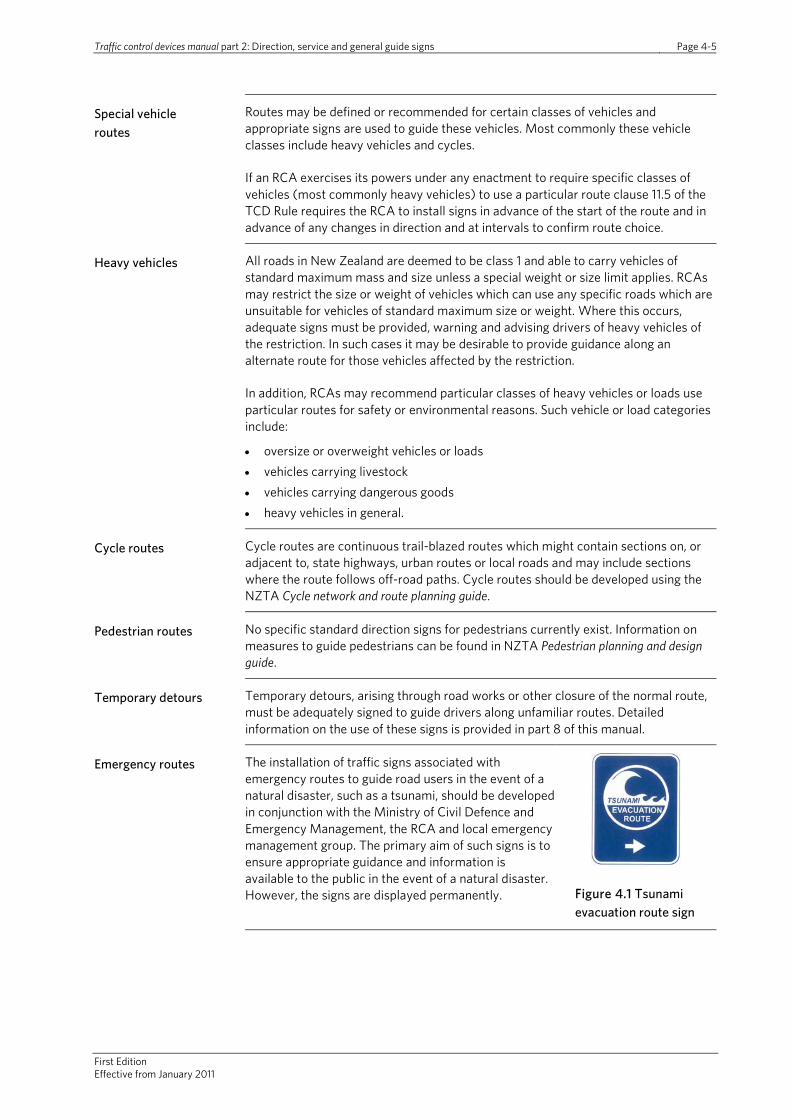
Emergency routes The installation of traffic signs associated with emergency routes to guide road users in the event of a natural disaster, such as a tsunami, should be developed in conjunction with the Ministry of Civil Defence and Emergency Management, the RCA and local emergency management group. The primary aim of such signs is to ensure appropriate guidance and information is available to the public in the event of a natural disaster. However, the signs are displayed permanently.
Figure 4.1 Tsunami evacuation route sign

Traffic control devices manual Part 2: Direction, service and general guide signs Page 4-6
First edition Effective from January 2011
Emergency routes continued
Because they are also likely to be directing drivers along routes which, under normal conditions, require advance, intersection and confirmation direction signs it is important the emergency route signing is not installed at the same location or be placed where the direction signs could be obscured. The sign described in figure 4.1 is classified as a traffic sign, which allows the use of reflectorised material. Therefore, they are consequently subject to the TCD Rule and basic design issues contained in part 1 of this manual.
Guidance on other tsunami emergency signs can be found in National tsunami signage technical standards for the CDEM sector TS01/08 (Ministry of Civil Defence & Emergency Management, 2008).
Toll roads and free alternate routes
A toll road is most likely to be either a motorway or an expressway and therefore current sign policy for toll roads is covered in TCD anual art 10. A toll road, just as with motorways and expressways, is generally defined not only by signs but also by the geometric standards applied along the length of the route. These provide clear indication of route. However, for the purposes of this, a toll route has the potential for creating a route discontinuity for a road user who does not wish to pay a toll.
A current legal requirement before a publicly-funded toll route can be established is that an alternate free route is available. There is, therefore, a need to give advance warning of the toll road to approaching road users and, for those who do not wish to use the toll road, directions should be provided to and along the free route so they can rejoin the main route beyond the tolled section.
4.4 Route and guide sign layout and details
Sign specifications Specifications for route and guide traffic signs are available in the TCD Rule.
The TCD manual section on sign specifications, currently under development, will provide images that will guide sign designers and manufacturers. Published signs can be viewed on the NZTA’s website (www.nzta.govt.nz/resources/traffic-control-devices-manual/sign-specifications/).
General layout and design
General layout and design details that are common to various types of route and guide signs are described below.
Colour and reflectivity
In general advance direction, intersection direction and confirmation direction signs have white borders and legends on either green or blue backgrounds. For local roads (ie non-state highway), the preferred background colour is green although in line with the TCD Rule, blue is acceptable. However, the mixing of background colours on the same sign is not encouraged. Where this occurs, the transition between the different colours should be separated by a white border. All signs on the state highway must have a green background colour. The mixing of panel colours on state highway direction signs is discouraged.
Route indicators along state highways must have white legends and borders on a red background. Along urban routes, route indicators must have a black legend and border on a white background.
All guide and route signs must be fully reflectorised in accordance with the requirements set out in the TCD Rule.

Traffic control devices manual part 2: Direction, service and general guide signs Page 4-7
First Edition Effective from January 2011
Lettering Guide sign letter shapes must conform to the alphabets defined in AS1744:1975.
Modified series E, lower case alphabet, with initial capitals, is only used for destination and stage names. All other lettering on guide signs should be series D or E capitals of the same height as the lower case letters used for the destination legend. This includes:
• additional directional information • additional driving instructions, and • street names.
Letter size depends on approach speed, the amount of legend on the sign and lateral and/or vertical placement of the sign. Recommended minimum letter sizes to be used on guide signs for a range of road types are shown in table 4.1.
Further information on letter type and size will be given in the traffic signs specifications on the NZTA’s website (www.nzta.govt.nz/resources/traffic-control-devices-manual/sign-specifications/). Where guide signs are used on motorways and expressways, TCD Manual part 10)should also be referenced for correct letter sizes.
Table 4.1 Letter sizes on guide signs
Road type Minimum letter size
Two-lane urban roads with one lane in each direction
Advance direction, advance lane designation and confirmation direction signs: not less than 120mm high
Intersection direction signs: not less than 160mm high
Two-way urban and rural roads with up to two lanes in each direction
Not less than 160mm high
Multi-lane rural roads with more than two lanes in each direction
Not less than 160mm high
Overhead advance direction signs in any location Not less than 240mm high
Other factors which may affect letter or sign size are:
• distractions due to roadside activity and/or background • short legends – a sign may need to be enlarged to ensure it is more conspicuous • short and long legends – it may be necessary to either increase the letter size of
the short legend or to select a letter size which ensures each has approximately equal visual impact
• a need to emphasise a more important direction by making it larger than other place names on the sign
• place names or street names should not be abbreviated, however, to reduce the overall length of a sign where one destination name is of abnormal length, standard abbreviations for the descriptor of a road, eg ‘Rd’ for road, ‘St’ for street, may be used (refer to section 7 for standard abbreviations)
• the maximum number of names or words recommended on a guide sign is five.

Traffic control devices manual Part 2: Direction, service and general guide signs Page 4-8
First edition Effective from January 2011
Legend Guide sign design principles restrict the amount of legend that can be shown based upon research on the maximum amount of information a driver can reasonably read, understand and act on during the time a sign is within legible range. Additional information to that recommended in this manual should not be added to guide sign messages. Such information may significantly reduce a driver’s ability to read the message displayed and to act safely on the information received.
Route indicator symbols
Route indicators supplement destination names and form a very important part of the guide sign system, particularly for travellers who are not familiar with the English language. The incorporation of such indicators is subject to RCA policy.
Where used, the numerals on a route indicator symbol must be at least the same size as the lettering used for the associated destination name in order to be effective.
Route indicators should be positioned between the destination name and the arrow, or chevron stripe, direction indicator.
Distances Distances given on guide signs should be shown as follows:
• Up to 950m in 100m increments to the nearest 100m (shown as xxx m). • More than 950m in 1km increments to the nearest km (shown as x km).
Dual names Generally, no more than two place names should be shown in any direction of travel on either advance direction or intersection direction signs. Therefore, when a dual name is to be shown, only one destination should be shown in that direction. When a dual name is to be shown on an existing advance direction or intersection sign that has more than one destination in that direction, the relevant authorities should decide which is the more important destination and which name is to be removed. Any place names removed from the advance direction sign must be also removed from the associated intersection direction sign.
Place name(s) removed from advance direction and intersection direction signs may however remain on confirmation direction signs, provided the maximum number of names allowed (five, including dual names) on this type of sign is not exceeded.
Further guidance on the design of signs incorporating dual names can be found in appendix A and section 5.5, part 1 of this manual.
Variations Normally, guide signs would conform to one of the typical layouts set out in Sections 4.6 to 4.14. However, when a special sign is required, the general sign layout rules described in TCD specifications should be applied.

Traffic control devices manual part 2: Direction, service and general guide signs Page 4-9
First Edition Effective from January 2011
4.5 Forms of route and guide signs
Different types of signs exist to guide road users through the road network. Route and guide signs are described below and cover the following:
• route indicator symbols and signs • advance information signs • advance direction signs • intersection direction signs • confirmation direction signs • destination signs • route end signs • special vehicle routes.
Advance, intersection and confirmation guide signs should be provided on all approaches and departures at intersections of major roads (state highway and local roads designated as arterial roads in the local district plan or similar document).
At major road intersections with minor roads, guide signs in the form of intersection direction signs (showing destinations and distances) or street name signs should be considered, taking into account forward visibility and the potential need for advance direction signs.
4.6 Route indicator symbols and signs
Route identification, by means of a route number or symbol system using distinctively shaped or coloured route indicators, can assist with road user navigation around the road network. They can be important to indicate major routes or major services (such as hospitals or airports), or delineate temporary detours for road works or incidents.
Route indicators should be provided at the beginning, along the length and at the end of a marked route. Routes that warrant such identification include state highways, urban routes, toll roads, named touring routes, routes to special locations, eg airports, hospitals, information centres. Each of these routes should be uniquely identifiable – either through the use of a stand-alone sign showing the route indicator or as part of a guide sign with the route indicator included.
Routes may be identified by using:
• free-standing signs (simply with the route indicator and possibly an arrow) located at regular intervals along a road, to reassure drivers they are following the correct route, or
• route identification symbols on guide signs to supplement text information.
Route identification systems are only effective if:
• routes are identified throughout without gaps • the signs are maintained in good condition, and • for other than temporary detours and emergency routes, the route numbers or
symbols are shown on road maps which are readily available to the public.

Traffic control devices manual Part 2: Direction, service and general guide signs Page 4-10
First edition Effective from January 2011
It is important there are as few changes as possible after a route numbering system is established so that published road maps remain relevant as long as possible.
Route indicator signs should be located on the left side of the road except in special cases such as channelised intersections where they may be more appropriately located on central islands.
If there are likely to be a number of route indicators on one pole or sign there will be a need to develop a policy defining their relative placement. This would be developed by the RCA with any adjacent or other affected RCA.
Route indicators should be located so that drivers have an uninterrupted view of them for at least 120m in rural areas and 60m in urban areas.
State highway route indicators
State highway route indicators are specifically identified in the TCD Rule as reflectorised red shields with a horizontal top with reflectorised white border, number and, where used, letter.
Free-standing route indicators should be erected on the left side of all state highways at:
• intervals not exceeding 15km, and • approximately 400m past the more important
rural intersections where confirmation direction signs are not warranted.
Supplementary plates below the shield denoting the start and end of a state highway that is not an intersection with another state highway should also be provided where appropriate.
Figure 4.2 State highway route indicators
Urban route indicators
The TCD Rule permits the use of a reflectorised white shield with a black urban route number and border to be provided to help designate urban routes. Their shape differs from state highway route indicator shields having a straight top and sides.
Urban route indicator signs should be used in accordance with the following principles:
Figure 4.3 Typical urban route indicator
• Route number signs should be used to identify an urban route between major intersections.
• A combination of route numbers and place names will generally provide guidance for road users.
• Urban route numbers may be added to state highway and motorway signs where appropriate.
It may also be necessary to increase shield sizes on some signs, for example on overhead motorway gantry signs.
When used on advance direction signs, the route number shield should be located between the place name (destination) and the direction arrow. The size of the shield is adjusted so that the numeral is the same height as the initial capital letters used for the associated destination name.

Traffic control devices manual part 2: Direction, service and general guide signs Page 4-11
First Edition Effective from January 2011
Named touring routes
When used, a named touring route logo should be positioned alongside and to the right of any state highway shield, or urban route indicator.
Where a named touring route is long and uses a range of different road types (state highways, other major roads and local roads), regular confirmation is required along all roads that form the named touring route. This should be achieved by installing the symbolic logo associated with the particular touring route at intervals not exceeding 15km.
Figure 4.4 Examples of inter-regional named touring route logos
Logos may be attached to any existing route indicator sign alongside and to the right of the route indicator logo, or they may be located below the route indicator logo if necessary.
Route indicator logos should also be provided on advance direction, intersection direction and confirmation direction signs as described below.
The named touring route logos should be provided within a maximum dimension of 390 x 390mm.
Figure 4.5 Example of local tourist drive indicator
Local named touring routes (tourist or scenic drives, heritage trails, etc) should be signed by route indicators which may be in the form of:
• plaques of a distinctive shape and colour which do not conflict with other traffic signs (maximum dimension 500 x 500mm)
• frangible bollards of a distinctive shape and colour - in rural areas only (maximum height of 1m and maximum width or diameter of 200mm).
Routes to special destinations
Emergency medical services
The emergency medical services symbol should only be used to indicate services providing 24-hour medical treatment. Signs displaying this symbol may include appropriate wording to show the type of service, eg DOCTOR, HOSPITAL, A & E, etc.
Figure 4.6 Medical services symbol
The hospital name may also be included if there is more than one hospital in the area.
In some situations it may be necessary to have a hospital route system signed as part of an overall sign scheme.
Airfields
Major airports should be shown as destinations on guide signs, ie they should form part of the legend on advance and intersection direction signs on the route to the airport.
Figure 4.7 Airfield symbol

Traffic control devices manual Part 2: Direction, service and general guide signs Page 4-12
First edition Effective from January 2011
Routes to special destinations continued
Information centres
Given the significant role information centres can play in guiding tourists and visitors around the road network the information centre symbol may be used to indicate a route to an information centre.
Figure 4.8 Information symbol
Information centres should be shown as destinations on guide signs, ie they should form part of the legend on advance and intersection direction signs on the route to the centre.
Special vehicle routes
Examples of special vehicle routes could include dangerous goods routes or heavy vehicle routes. Heavy vehicle routes may be indicated by the use of the heavy vehicle symbol in much the same way as described above in routes to special destinations.
Figure 4.9 Symbols for heavy vehicle and cycle routes
Cycle routes should utilise the white cycle symbol on blue background as an indicator.
Use of multiple indicator symbols on signs
Where more than one route indicator is used on a sign (for example a state highway shield combined with an urban route shield, a named touring route symbol or a special destination symbol) the same order should be used on all signs using the same combination along the route. Where a state highway shield is used it should appear on the extreme left of the combination.
The combination of indicators should be located between the place name (destination) and the direction arrow.
Detours Temporary detours use one of the white circle, diamond or square route indicators shown in figure 4.10. See part 8 for details.
Where sections of a major road may be prone to regular closures (eg due to snow, floods, etc) the alternate route may be signed using a similar process for temporary detours and utilise a symbol relevant to the route closed. For example an alternate route to a state highway could use the state highway shield symbol to indicate the route (see figure 4.11).
Figure 4.10 Standard symbols used on temporary detours
Figure 4.11 Symbol used to indicate an alternate route for a closed state highway
The advance information and both the first advance direction and intersection directions signs are not displayed unless the major road closure occurs. The indicators used elsewhere along the route may be displayed.

Traffic control devices manual part 2: Direction, service and general guide signs Page 4-13
First Edition Effective from January 2011
Toll roads Toll roads are indicated by the use of reflectorised red shields with a horizontal top and reflectorised white border with the legend TOLL in reflectorised white capital letters within the shield.
Where a free alternate to a toll road is not a state highway, urban route or named touring route the use of the words FREE ROUTE as an indicator is recommended.
Figure 4.12 Toll road indicator
4.7 Advance information signs
Named touring routes
Advance information signs should be installed about 500m before the advance direction sign for the intersection at the commencement of the route. This sign will announce:
• the name of the touring route and its logo • the route’s features or attractions in no more than four symbols or six words, and • if appropriate, its length or extra length where this is greater than a more direct
route.
This information would not be repeated along the length of the named touring route.
Where the named touring route is a state highway the sign will have reflectorised white lettering on a reflectorised green background. For other named touring routes the signs will have reflectorised white lettering on a reflectorised brown background.
Toll roads Direction signs must be provided on untolled roads sufficiently in advance of the toll road to allow road users sufficient time and opportunity, if they wish, to avoid the toll road and use an alternative free route. Direction signs should also be used at the final intersection prior to the toll road. All roads approaching and intersecting with a toll road should be sufficiently signed to provide advice to drivers of the toll road.
Direction signs must be provided on untolled roads sufficiently in advance of the toll road to allow road users sufficient time and opportunity, if they wish, to avoid the toll road and use an alternative ‘free’ route. Direction signs should also be used at the final intersection prior to the toll road. All roads approaching and intersecting with a toll road should be sufficiently signed to provide advice to drivers of the toll road.
Directions should be provided on the free route so road users can rejoin the main route beyond the tolled section.
Figure 4.13 Advance toll road begins sign with distance
Figure 4.14 Advance toll road sign with alternative route guidance
Traffic control devices manual Part 2: Direction, service and general guide signs Page 4-14
First edition Effective from January 2011
4.8 Advance direction
Advance direction signs are located on the approaches to intersections before the commencement of the route and in advance of intersections along its length. They indicate the destinations on each road leading away from the intersection including, where appropriate, the next major destination on those roads. Where applicable, the signs show state highway, regional or local route indicator symbols and may also include the names of important intersecting roads.
Advance direction signs should be provided on
• all approaches where a major road intersects with a major road • on approaches to intersections where the major road changes direction.
There are three types of advance direction signs – free-standing indicators, stack or map. Each of these sign types is used in different situations and RCAs should set down their policy for providing each type. To ensure consistency of information to road users however, the following advance direction sign regime should be adhered to:
• free-standing indicators (which may be route indicator symbols with arrows indicating direction or the symbol oriented to depict direction) are provided in less complicated environs where the stack or map signs would not be justified
• stack signs should be installed at major road intersections • map signs should be provided at complicated or complex intersections,
roundabouts or successive intersections as well as where major roads intersect with other major roads.
In some situations, particularly on multi-lane approaches to complicated junctions or on high-speed roads such as motorways, advance lane designation signs are required to guide drivers into the correct lane to follow the route.
4.8.1 Free-standing indicators
Urban routes These signs should be erected:
• in advance of the intersection of two or more numbered routes • in advance of an intersection where a numbered route turns • in advance of an intersection where the surface of the route changes markedly, eg
sealed to unsealed • in advance of the intersection of a numbered route with a major road • where desirable, on major road approaches to intersections with numbered
routes.

Traffic control devices manual part 2: Direction, service and general guide signs Page 4-15
First Edition Effective from January 2011
Urban routes continued
Table 4.2 Urban route indicator supplementary arrow signs
Supplementary plate located above route number to guide road users on a particular urban route
Sign examples
Goes to the left or right
Continues straight ahead
Veers to left or right at intersection
Runs straight ahead and to the left or right
Runs both left and right
Sign assemblies Where a number of urban route indicator shields and arrows are to be placed at one location, and face in one direction they should be erected on one post in the following manner:
• two shields with arrows should be placed one above the other
• three or five shields with arrows should be placed with one of them in a central position, and
• the general arrangement should indicate the geometric layout of the intersection ahead.
If the intersection includes a state highway on one or more of its approaches, the appropriate state highway route indicator shield should be used with a supplementary arrow.
Figure 4.15 Typical urban route indicator sign assembly
Named touring routes
Advance indicators should be provided prior to an intersection with an arrow angled in the direction to take. They may be used in conjunction with other route indicators.
Traffic control devices manual Part 2: Direction, service and general guide signs Page 4-16
First edition Effective from January 2011
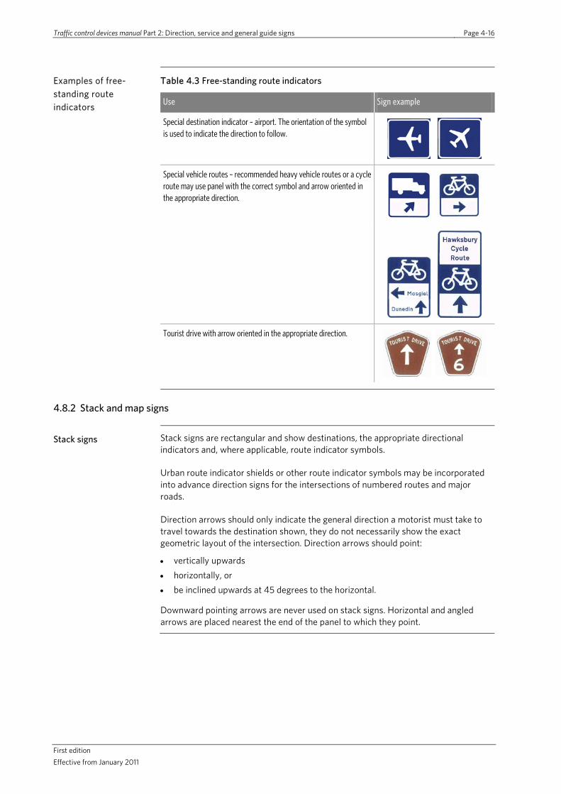
Examples of free-standing route indicators
Table 4.3 Free-standing route indicators
Use Sign example
Special destination indicator – airport. The orientation of the symbol is used to indicate the direction to follow.
Special vehicle routes – recommended heavy vehicle routes or a cycle route may use panel with the correct symbol and arrow oriented in the appropriate direction.
Tourist drive with arrow oriented in the appropriate direction.
4.8.2 Stack and map signs
Stack signs Stack signs are rectangular and show destinations, the appropriate directional indicators and, where applicable, route indicator symbols.
Urban route indicator shields or other route indicator symbols may be incorporated into advance direction signs for the intersections of numbered routes and major roads.
Direction arrows should only indicate the general direction a motorist must take to travel towards the destination shown, they do not necessarily show the exact geometric layout of the intersection. Direction arrows should point:
• vertically upwards • horizontally, or • be inclined upwards at 45 degrees to the horizontal.
Downward pointing arrows are never used on stack signs. Horizontal and angled arrows are placed nearest the end of the panel to which they point.

Traffic control devices manual part 2: Direction, service and general guide signs Page 4-17
First Edition Effective from January 2011
Stack signs continued
The vertical sequence of panels on an advance direction stack sign should, as far as practicable, be:
• straight ahead arrows in the top panel • angled arrows above horizontal arrows, and • angled or horizontal arrows indicating opposite
directions placed in alternate panels.
Note that alternating the arrows can start on either side as shown in the stack sign examples in table 4.4. Arrows should not be placed on the sign on the same side for every panel.
Figure 4.16 Stack sign showing how arrows should not be used
When route indicator symbols are shown they are always placed between the destination name and the directional arrow. When a single-route indicator symbol applies to two destinations in different directions, the route indicator symbol is positioned centrally at the top of the sign with the two different destinations and arrows shown below. A straight ahead panel may be added above such a sign layout when appropriate.
Stack signs should not have more than five lines of legend or more than two lines in any one panel with the exception of stack signs showing two destinations in different directions which may have up to four lines of legend and a route indicator symbol (if appropriate).
A route indicator symbol is also considered a line of legend, therefore, if the destination is reached by travelling on that particular highway then it should be located next to the location to which it refers.
Table 4.4 Example advance direction stack signs
Use Sign example
On the approaches to an intersection of a state highway and a major crossroad
Touring route logos should be included on advance direction signs at intersections along touring routes where the touring route changes direction
On the approach to an intersection of a state highway and a major road which meets at an angle other than 90 degrees to the through road
On the approach to state highway and major road intersections where the same route number exists in each direction across the approach road
Destination 1
Destination 2
Destination 3

Traffic control devices manual Part 2: Direction, service and general guide signs Page 4-18
First edition Effective from January 2011
Map signs Map signs should be provided on all approaches to intersections of major roads. Map signs should also be considered at other complicated intersections, at roundabouts, for successive road intersections, and where a stack sign would not adequately show an unusual intersection or road layout.
Map signs are rectangular and show the directions for various destinations in a pictorial way. The letter size used for map sign legends must be no smaller than that required for the equivalent stack sign in the same location. This will usually result in a sign considerably larger than the equivalent stack sign.
When a route indicator symbol is shown it should be positioned:
• in the same way as a stack sign, ie on the same line, and adjacent, to a destination name, or
• adjacent to the point of the relevant map directional arm.
Map type signs should not show more than five destination names or more than two names in any one particular direction.
Table 4.5 Example advance direction map signs
Use Sign example
On the approach to an intersection where route numbers change
On the approaches to successive intersections
On the approaches to a roundabout with one or more major roads.
Traffic control devices manual part 2: Direction, service and general guide signs Page 4-19
First Edition Effective from January 2011
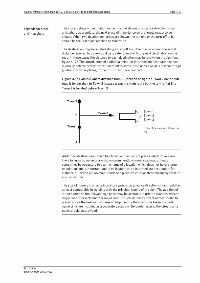
Legends for stack and map signs
The closest stage or destination name must be shown on advance direction signs and, where appropriate, the next place of importance on that route may also be shown. When two destination names are shown, the top one or the turn-off to it, should be the first place reached on that route.
The destination may be located along a turn-off from the main road and the actual distance required to travel could be greater than that to the next destination on the road. In these cases the distance to each destination may be shown on the sign (see figure 4.17). The introduction of additional minor or intermediate destination names is usually determined by the requirement to show these names on all subsequent sign guides until those places, or the turn-off to it, are reached.
Figure 4.17 Example where distance from A (location of sign) to Town 2 on the side road is longer than to Town 3 located along the main route but the turn-off at B to Town 2 is located before Town 3
Additional destinations should be chosen on the basis of places which drivers are likely to know by name or are shown prominently on most road maps. It may sometimes be necessary to use the name of a location which does not have a large population, but is important due to its location as an intermediate destination, for instance a junction of two major roads or a place which is located reasonably close to such a junction.
The size of numerals in route indicator symbols on advance direction signs should be at least comparable in legibility with the principal legend of the sign. The addition of street names on the relevant sign panel may be desirable in urban situations where a major road intersects another major road. In such instances, street names should be placed above the destination name to help identify the road to be taken. If street name signs are included as a separate panel, a white border around the street name panel should be provided.
Town 1 Town 2 Town 3 Order of destinations shown on sign

Traffic control devices manual Part 2: Direction, service and general guide signs Page 4-20
First edition Effective from January 2011
Location and mounting of stack and map signs
The main purpose of an advance direction sign is to give drivers approaching an intersection prior information which will enable them to make decisions and, if necessary, to reposition their vehicles before reaching the intersection. The distance at which a sign is located before an intersection is therefore mainly dependent on the speeds of approaching vehicles.
Advance direction signs should be located within the distance ranges given in table 4.5, but never less than the minimum distance specified for the particular road environment.
Table 4.6 Location of an advance direction sign from an intersection
Road environment Distance from intersection (m)
Rural V85: < 75 km/h 80 – 120
V85: 75 – 90 km/h 120 – 180
V85: > 90 km/h 180 – 250
Urban Arterial roads As for a rural environment
Business and residential areas 30 - 100
Notes:
1. V85 = 85th percentile speed of vehicles approaching the sign position.
2. The distance ranges shown are for signs where simple decisions have to be made or only one or two route choices are available. These should be increased by about one second of travel time for each additional choice or element of complexity.
3. At channelized intersections with separate turn lanes, distances should be measured from the start of the turn lane.
4. At locations where approach speeds are high (V85: > 90 km/h) and much of the approaching traffic makes a turn at the intersection, some extra advance direction information may be needed. In these cases an advance lane designation sign including the distance may be erected approximately 400m in advance of the intersection.
In urban areas, some desirable sign locations may be unsuitable because of roadside development, shop awnings, advertising signs or intersecting streets, etc. It may sometimes be necessary to cantilever signs over the road and to locate them much closer to intersections than would otherwise be desirable. The lettering on these signs may need to be increased in size. In addition, in urban areas a supplementary sign showing the distance in metres to the intersection may also be necessary where there are minor side streets between the sign and the intersection. Alternatively, a map type sign may be a better solution in many situations.
4.9 Advance lane designation signs
Advance lane designation signs are normally only necessary on the approaches to intersections on high volume, multi-lane roads. In these situations, drivers may need additional directions or reminders about the correct lane to use for their intended movement at the intersection.
Conventional advance direction signs should be used in conjunction with advance lane designation signs (except where a sign assembly mounted on a gantry over the roadway gives all necessary directional information). Destinations shown on advance direction signs are replicated on advance lane designation signs.
Traffic control devices manual part 2: Direction, service and general guide signs Page 4-21
First Edition Effective from January 2011
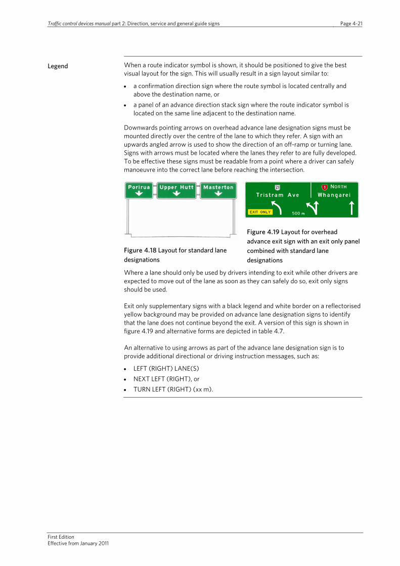
Legend When a route indicator symbol is shown, it should be positioned to give the best visual layout for the sign. This will usually result in a sign layout similar to:
• a confirmation direction sign where the route symbol is located centrally and above the destination name, or
• a panel of an advance direction stack sign where the route indicator symbol is located on the same line adjacent to the destination name.
Downwards pointing arrows on overhead advance lane designation signs must be mounted directly over the centre of the lane to which they refer. A sign with an upwards angled arrow is used to show the direction of an off-ramp or turning lane. Signs with arrows must be located where the lanes they refer to are fully developed. To be effective these signs must be readable from a point where a driver can safely manoeuvre into the correct lane before reaching the intersection.
Figure 4.18 Layout for standard lane designations
Figure 4.19 Layout for overhead advance exit sign with an exit only panel combined with standard lane designations
Where a lane should only be used by drivers intending to exit while other drivers are expected to move out of the lane as soon as they can safely do so, exit only signs should be used.
Exit only supplementary signs with a black legend and white border on a reflectorised yellow background may be provided on advance lane designation signs to identify that the lane does not continue beyond the exit. A version of this sign is shown in figure 4.19 and alternative forms are depicted in table 4.7.
An alternative to using arrows as part of the advance lane designation sign is to provide additional directional or driving instruction messages, such as:
• LEFT (RIGHT) LANE(S) • NEXT LEFT (RIGHT), or • TURN LEFT (RIGHT) (xx m).

Traffic control devices manual Part 2: Direction, service and general guide signs Page 4-22
First edition Effective from January 2011
Location and mounting
Advance lane designation signs should be located beside or over one or more of the intersection approach lanes. Support structures for overhead advance direction signs are usually very costly and alternative signing which could satisfactorily perform the same functions should be carefully considered.
Overhead advance lane designation signs may not be effective where the road curves just before the sign location as drivers may not be able to relate the downward pointing sign arrows with the traffic lanes marked on the road pavement.
Additional direction or driving instructions, such as left lane, next left or turn left may only be used on roadside-mounted signs, or on single overhead advance direction signs which do not project completely over the lane to which it refers to. Such signs are normally located just before the start of a turning lane, although signs with direction or distances incorporated will generally need to be located further in advance of the intersection.
Advance lane designation signs should be used in combination with advance direction sign with the lane designation sign located above where the lane commences. As suggested in part 10 of this manual, ideally this should be half the distance between the advance direction sign and the turn-off, but is primarily dependent upon the start of the actual traffic lane.
Table 4.7 Advance lane designation sign types
Type of advance lane designation sign
Use Sign examples
Lane assignment sign
When traffic lane the sign refers to is fully developed and marked
Additional direction message
On roadside-mounted signs or on a single overhead sign which does not project completely over the lane it refers to
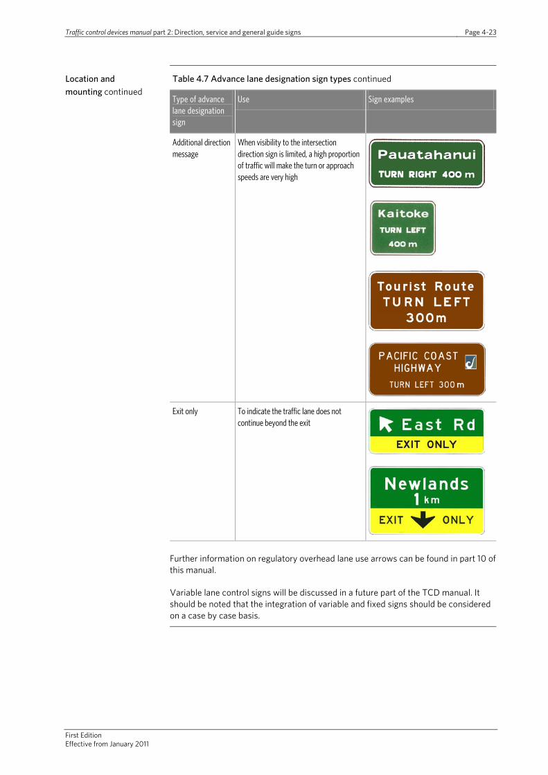
Traffic control devices manual part 2: Direction, service and general guide signs Page 4-23
First Edition Effective from January 2011
Location and mounting continued
Table 4.7 Advance lane designation sign types continued
Type of advance lane designation sign
Use Sign examples
Additional direction message
When visibility to the intersection direction sign is limited, a high proportion of traffic will make the turn or approach speeds are very high
Exit only To indicate the traffic lane does not continue beyond the exit
Further information on regulatory overhead lane use arrows can be found in part 10 of this manual.
Variable lane control signs will be discussed in a future part of the TCD manual. It should be noted that the integration of variable and fixed signs should be considered on a case by case basis.

Traffic control devices manual Part 2: Direction, service and general guide signs Page 4-24
First edition Effective from January 2011
Heavy vehicle bypass advance direction sign
Where a heavy vehicle bypass exists to allow heavy vehicles to avoid a particular location– for instance a section of road with weight or dimension restrictions - it should be signed in advance of the intersection to provide guidance to ensure heavy vehicles use the restricted route.
These signs should be installed 100m to 300m in advance of the vehicle bypass at a suitable location where it is visible for at least 60m.
Figure 4.20 Bypass sign
Detours and emergency routes
Temporary detours use one of the white circle, diamond or square route indicators shown in figure 4.10 (see part 8 for details).
Where an alternate route is used when the major route is subject to regular closures a similar process for temporary detours utilising a symbol relevant to the route closed may be used (see figure 4.21). Such a sign should be displayed only when the normal major route is closed.
Figure 4.21 Advance sign for detours
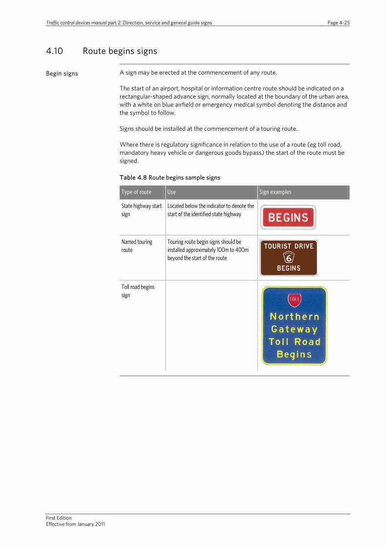
Traffic control devices manual part 2: Direction, service and general guide signs Page 4-25
First Edition Effective from January 2011
4.10 Route begins signs
Begin signs A sign may be erected at the commencement of any route.
The start of an airport, hospital or information centre route should be indicated on a rectangular-shaped advance sign, normally located at the boundary of the urban area, with a white on blue airfield or emergency medical symbol denoting the distance and the symbol to follow.
Signs should be installed at the commencement of a touring route.
Where there is regulatory significance in relation to the use of a route (eg toll road, mandatory heavy vehicle or dangerous goods bypass) the start of the route must be signed.
Table 4.8 Route begins sample signs
Type of route Use Sign examples
State highway start sign
Located below the indicator to denote the start of the identified state highway
Named touring route
Touring route begin signs should be installed approximately 100m to 400m beyond the start of the route
Toll road begins sign

Traffic control devices manual Part 2: Direction, service and general guide signs Page 4-26
First edition Effective from January 2011
4.11 Intersection direction signs
Intersection direction signs are located at intersections and show destinations on the roads leading away from the intersection. Intersection direction signs also highlight the presence of an intersection and the point of conflict with entering traffic (especially if the road pavement markings are not readily visible).
Figure 4.22 Dual name intersection direction sign
They also provide a guide for drivers when they are selecting the correct route through a complex channelized intersection (ie they can help to deter wrong-way and misdirected movements). These functions must be taken into account when positioning the signs at intersections.
All destinations shown on advance direction signs must be repeated on the relevant intersection direction sign.
Intersection direction signs do not normally show the names of the intersecting roads. When it is considered necessary to add the name of a major road it may be shown as:
• an additional street name sign plate erected immediately above the intersection direction sign, or
• a coloured insert panel positioned immediately above the destination name on the sign.
Shape Intersection direction signs are normally rectangular in shape with their long axis horizontal. One or both ends of a sign may be shaped as a point to indicate the direction, or directions, to be followed.
Intersection direction signs with a pointed end and chevron stripe to indicate the direction, should normally be used where the direction indicated is approximately at right angles to the approaching driver.
Rectangular signs with an arrow within the sign to indicate the general direction to be followed should be used where the direction indicated is straight ahead or angled away from the approaching driver (up to approximately 45 degrees). Such signs should also be used to indicate a horizontal direction when mounted with one or more signs indicating angled or straight ahead directions.
Where lateral space is restricted at urban intersections, a rectangular intersection direction sign layout may be used. In such circumstances, the arrow and route indicator symbol are positioned:
• above the destination name for straight ahead direction indications, and • below the destination name for horizontal or angled direction indications.
Fingerboard type signs should be used to indicate the direction of a specific locality at an intersection.
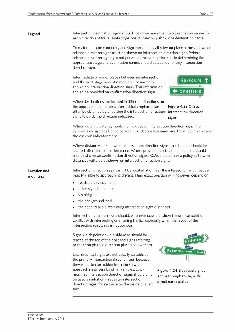
Traffic control devices manual part 2: Direction, service and general guide signs Page 4-27
First Edition Effective from January 2011
Legend Intersection destination signs should not show more than two destination names for each direction of travel. Note fingerboards may only show one destination name.
To maintain route continuity and sign consistency all relevant place names shown on advance direction signs must be shown on intersection direction signs. Where advance direction signing is not provided, the same principles in determining the appropriate stage and destination names should be applied for any intersection direction sign.
Intermediate or minor places between an intersection and the next stage or destination are not normally shown on intersection direction signs. This information should be provided on confirmation direction signs.
When destinations are located in different directions on the approach to an intersection, added emphasis can often be obtained by offsetting the intersection direction signs towards the direction indicated.
Figure 4.23 Offset intersection direction signs
When route indicator symbols are included on intersection direction signs, the symbol is always positioned between the destination name and the direction arrow or the chevron indicator stripe.
Where distances are shown on intersection direction signs, the distance should be located after the destination name. Where provided, destination distances should also be shown on confirmation direction signs. RCAs should have a policy as to when distances will also be shown on intersection direction signs.
Location and mounting
Intersection direction signs must be located at or near the intersection and must be readily visible to approaching drivers. Their exact position will, however, depend on:
• roadside development • other signs in the area • visibility • the background, and • the need to avoid restricting intersection sight distances.
Intersection direction signs should, wherever possible, show the precise point of conflict with intersecting or entering traffic, especially when the layout of the intersecting roadways is not obvious.
Signs which point down a side road should be placed at the top of the post and signs referring to the through road direction placed below them.
Low-mounted signs are not usually suitable as the primary intersection direction sign because they will often be hidden from the view of approaching drivers by other vehicles. Low-mounted intersection direction signs should only be used as additional repeater intersection direction signs, for instance on the inside of a left turn.
Figure 4.24 Side road signed above through route, with street name plates

Traffic control devices manual Part 2: Direction, service and general guide signs Page 4-28
First edition Effective from January 2011
Example intersection direction signs
Table 4.9 Intersection direction signs
Type of intersection direction sign
Use Sign examples
Chevron indicator When the direction indicated is at right angles to the approaching road user
In the case of state highways, the touring name is not considered necessary where the route continues along the state highway and the logo is shown
Where this sign is at a T-junction, a chevron sign may not be needed but if used the chevron is installed below the intersection direction sign
Arrow When the direction indicated is straight ahead or angled away from the approaching road user
Arrow (restricted space)
At urban intersections with limited space restricting the use of chevron and arrow sign types
Signs with route indicator, chevron place name and distance. The route indicator should go nearest the chevron/arrow and distance should be read after the destination

Traffic control devices manual part 2: Direction, service and general guide signs Page 4-29
First Edition Effective from January 2011
Heavy vehicle bypass intersection position sign
Heavy vehicle bypass position signs should be provided at intersections to help guide heavy vehicles along the bypass route. As with other intersection position signs, they should be located at or directly opposite the point of entry to side road turn-off to the bypass with an arrow pointing in the appropriate direction.
Where the heavy vehicle bypass route is mandatory (eg RCA bylaw or other legal restriction) the heavy vehicle bypass intersection sign must have a reflectorised red border.
Figure 4.25 Heavy vehicle bypass intersection position sign
Detours and emergency routes
Temporary detour route signs utilise the appropriate symbol and arrow orientation.
Figure 4.26Temporary detour route signs
4.12 Confirmation direction signs
Confirmation direction signs are rectangular in shape and should normally have a longer horizontal axis. When a sign contains more than three destinations it may have a longer vertical axis.
Legend Where the road has a route number, the indicator symbol should be provided above the locality name(s) as further confirmation of the route being travelled on. If a locality on the sign is reached by use of a route with a different route number than the route currently being used, then the indicator symbol for that route may be shown in brackets after the destination (see table 4.10).
It is recommended that a maximum of five but preferably only three destinations be shown on confirmation direction signs. Distances should be measured from the sign position to the recognised centre of each destination and given to the nearest whole kilometre.
As a minimum, the legend must include all relevant destinations previously shown on advance direction and intersection direction signs. Additional destinations may also be shown, but only when: • there is space available on the sign, and • the additional destination names are able to be shown on all subsequent guide
signing until those places are reached.
Additional destinations should be selected according to the following criteria:
• Places that have tourist, historic or geographic interest or lie at the junction of a subsidiary route.
• When the route joins another route, place names on both routes may be included, subject to the rules limiting the number of destinations that may be shown.
• Destinations should appear in the order of distance from the intersection, with the shortest distance at the top of the sign (see figure 4.17 and accompanying text for detail).
Route identification by means of numbering or shield indicators is described further in section 4.6.

Traffic control devices manual Part 2: Direction, service and general guide signs Page 4-30
First edition Effective from January 2011
Location and mounting
Confirmation direction signs should be located approximately 50m to 150m beyond the intersection in urban areas and 400m beyond the intersection in rural areas. These signs confirm to drivers they have taken the correct path through the preceding intersection, advises them of the stage or intermediate destinations and the distances to them.
RCAs should have a policy on the provision of confirmation direction signs. It is recommended that confirmation direction signs be provided on all roads departing from major road intersections where advance direction and intersection direction signing have been provided.
When there are two or more relatively closely spaced intersections (ie less than 1km apart) or where a defined route changes direction through a series of intersections, the confirmation direction sign should be located beyond the last intersection. In these situations route indicators (where they are used for the route) should be erected just beyond each intermediate intersection to provide route confirmation.
Confirmation urban route indicator shields
These signs, generally simply a free-standing route indicator shield, should be located in the following manner:
• beyond all intersections of two or more numbered routes • beyond all intersections of a numbered route with a major road where urban route
indicator shields have been erected at the intersection • where considered necessary, beyond all intersections with major roads where
urban route indicator shields have not been at the intersection • at all other locations where confirmation is considered to be desirable.
Tourist confirmation indicators should be installed approximately 100m beyond an intersection when the tourist or scenic drive route has turned from the main through road. The tourist confirmation indicators should also be repeated along the route to ensure a driver does not travel more than five minutes at the prevailing traffic speed along the road without seeing either another direction sign or route indicator. Confirmation indicators have a direction arrow arranged vertically indicating the way ahead.

Traffic control devices manual part 2: Direction, service and general guide signs Page 4-31
First Edition Effective from January 2011
Example confirmation direction signs
Table 4.10 Confirmation direction signs
Use Sign example
Typical confirmation direction sign
Dual name confirmation direction sign
Confirmation direction sign with touring route logo
Confirmation direction sign with option of showing a different named route used later to reach a destination
To indicate and confirm the route of a tourist or scenic drive
To provide road users with confirmation that they are on a touring route
Typical guide sign layouts
Some layouts for intersections using advance direction, intersection and confirmation signs are shown in the figures in appendix B. These diagrams depict the type, number and location of signs recommended for some typical intersections.
The diagrams do not cover all intersection and sign situations. Guide sign for each particular site should be developed from first principles using the recommendations and requirements specified in the relative sections of this manual.
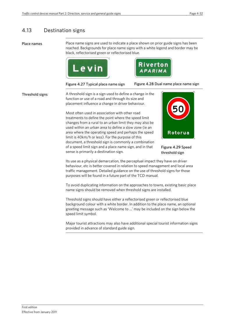
Traffic control devices manual Part 2: Direction, service and general guide signs Page 4-32
First edition Effective from January 2011
4.13 Destination signs
Place names Place name signs are used to indicate a place shown on prior guide signs has been reached. Backgrounds for place name signs with a white legend and border may be black, reflectorised green or reflectorised blue.
Figure 4.27 Typical place name sign
Figure 4.28 Dual name place name sign
Threshold signs A threshold sign is a sign used to define a change in the function or use of a road and through its size and placement influence a change in driver behaviour.
Most often used in association with other road treatments to define the point where the speed limit changes from a rural to an urban limit they may also be used within an urban area to define a slow zone (ie an area where the operating speed and perhaps the speed limit is 40km/h or less). For the purpose of this document, a threshold sign is commonly a combination of a speed limit sign and a place name sign, and in that sense is primarily a destination sign.
Figure 4.29 Speed threshold sign
Its use as a physical demarcation, the perceptual impact they have on driver behaviour, etc is better covered in relation to speed management and local area traffic management. Detailed guidance on the use of threshold signs for those purposes will be found in a future part of the TCD manual.
To avoid duplicating information on the approaches to towns, existing basic place name signs should be removed when threshold signs are installed.
Threshold signs should have either a reflectorised green or reflectorised blue background colour with a white border. In addition to the place name, an optional greeting message such as ‘Welcome to …’ may be included on the sign below the speed limit symbol.
Major tourist attractions may also have additional special tourist information signs provided in advance of standard guide sign.
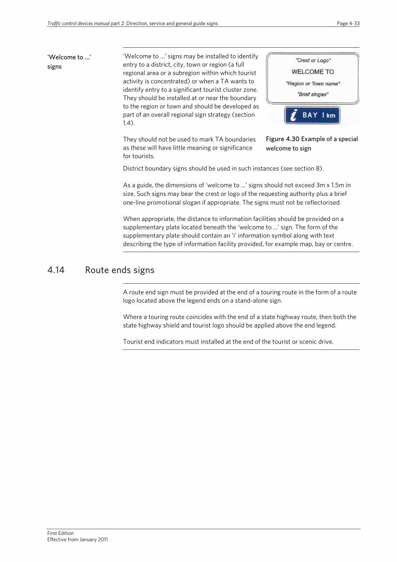
Traffic control devices manual part 2: Direction, service and general guide signs Page 4-33
First Edition Effective from January 2011
‘Welcome to …’ signs
‘Welcome to …’ signs may be installed to identify entry to a district, city, town or region (a full regional area or a subregion within which tourist activity is concentrated) or when a TA wants to identify entry to a significant tourist cluster zone. They should be installed at or near the boundary to the region or town and should be developed as part of an overall regional sign strategy (section 1.4).
They should not be used to mark TA boundaries as these will have little meaning or significance for tourists.
Figure 4.30 Example of a special welcome to sign
District boundary signs should be used in such instances (see section 8).
As a guide, the dimensions of ‘welcome to …’ signs should not exceed 3m x 1.5m in size. Such signs may bear the crest or logo of the requesting authority plus a brief one-line promotional slogan if appropriate. The signs must not be reflectorised.
When appropriate, the distance to information facilities should be provided on a supplementary plate located beneath the ‘welcome to …’ sign. The form of the supplementary plate should contain an ‘i’ information symbol along with text describing the type of information facility provided, for example map, bay or centre.
4.14 Route ends signs
A route end sign must be provided at the end of a touring route in the form of a route logo located above the legend ends on a stand-alone sign.
Where a touring route coincides with the end of a state highway route, then both the state highway shield and tourist logo should be applied above the end legend.
Tourist end indicators must installed at the end of the tourist or scenic drive.
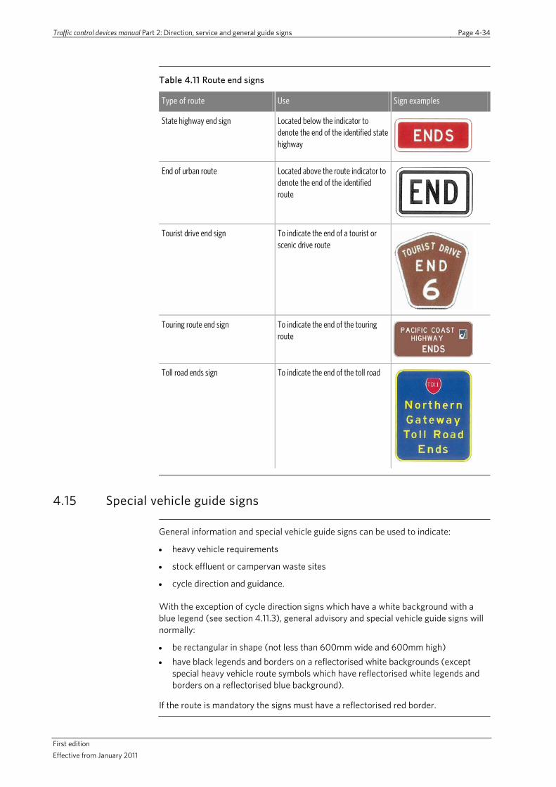
Traffic control devices manual Part 2: Direction, service and general guide signs Page 4-34
First edition Effective from January 2011
Table 4.11 Route end signs
Type of route Use Sign examples
State highway end sign Located below the indicator to denote the end of the identified state highway
End of urban route Located above the route indicator to denote the end of the identified route
Tourist drive end sign To indicate the end of a tourist or scenic drive route
Touring route end sign To indicate the end of the touring route
Toll road ends sign To indicate the end of the toll road
4.15 Special vehicle guide signs
General information and special vehicle guide signs can be used to indicate:
• heavy vehicle requirements
• stock effluent or campervan waste sites
• cycle direction and guidance.
With the exception of cycle direction signs which have a white background with a blue legend (see section 4.11.3), general advisory and special vehicle guide signs will normally:
• be rectangular in shape (not less than 600mm wide and 600mm high) • have black legends and borders on a reflectorised white backgrounds (except
special heavy vehicle route symbols which have reflectorised white legends and borders on a reflectorised blue background).
If the route is mandatory the signs must have a reflectorised red border.

Traffic control devices manual part 2: Direction, service and general guide signs Page 4-35
First Edition Effective from January 2011
Stock vehicles A National Stock Effluent Work Group convened by the New Zealand Road Controlling Authorities Forum developed A practical guide to providing facilities for stock effluent disposal from trucks and companion documents aimed at establishing stock truck effluent sites including sites adjacent to major roads.
Studies considering the location of stock effluent sites in both the north and south islands have established a desirable network of in-transit effluent dump sites. These are based on a range of assumptions relating to stock destinations and facilities, the size of effluent holding tanks and the proportion of stock that are stood for at least four hours prior to transportation.
Stock effluent disposal advance direction sign
Where a stock effluent disposal site exists, it shall be signed in advance to advise drivers of stock transporters of the presence of these facilities.
Advance direction signs are generally located on the left-hand side on both approaches to a stock effluent facility and should be located approximately 300m in advance of the disposal site access.
Figure 4.31 Stock effluent advance direction sig
Stock effluent disposal intersection position sign
Stock effluent disposal position signs should be located at or as close as possible to entry point to stock effluent disposal site with the arrow pointing to the facility.
Figure 4.32 Stock effluent position sign
Pedestrians It should be noted no standard directional signs for pedestrians exist. However, information on measures to guide pedestrians can be found in the NZTA Pedestrian planning and design guide.
Cyclist information signs
Guidance to cyclists at various locations, particularly along high-speed routes and/or at the on and off ramps can be provided through cycle information signs. As with other special vehicle signs, these signs are rectangular with black legends and borders on a white background.
Table 4.13 Cyclist information signs
Type of cyclist information
Use Sign examples
Use left shoulder Recommends cyclists to use the shoulder rather than the general traffic lane
Use ramp Recommends cyclists use the provided ramp to help avoid conflicts with high speed following vehicles at an off-ramp
Crossing point To indicate the recommended location for a cyclist to cross – typically used at the on and/or off ramps away from the merging entry/diverging exit point

Traffic control devices manual Part 2: Direction, service and general guide signs Page 4-36
First edition Effective from January 2011
This page is intentionally blank

Traffic control devices manual part 2: Direction, service and general guide signs Page 5-1
First edition Effective from January 2011
5.0 Service signs
5.1 Principles and application
Service signs are advisory signs used to indicate facilities that are:
• commonly required by travellers • located adjacent to the road or a reasonable distance along a side road • identified by an approved symbol.
Service signs form part of the overall road sign system but are, except in a few cases, not intended to guide travellers through the road network. It is assumed that some preparation will have been done by drivers before a journey is commenced. Accordingly, service signs should only be used to indicate specific services that are not obvious to travellers in the immediate vicinity of the service.
The application of the principles set out in this section will ensure a consistent and appropriate level of service signs on all New Zealand roads. At the intersections of roads controlled by different RCAs, one road should be designated the main road and the other the side road. In these situations, agreement between the adjoining RCAs should be obtained with respect to the installation and maintenance of service signs to direct traffic along the side road.
5.2 Forms of services signs
Different types of service signs exist to help indicate the location and type of provided facilities:
• information services • rest areas • commercial services • accommodation services • other services • bypassed communities.
Information services
Service signs may be used to indicate facilities which provide local area information likely to be of interest to travellers. As discussed in section 5.4, these facilities may be either unattended or attended.
Figure 5.1 Information site advance sign
Rest areas Rest areas are defined as places where vehicles can safely stop clear of the roadway and where services such as picnic tables, toilets, water, etc may also be available. Further details on rest areas can be found in section 5.5.
Figure 5.2 Position sign indicating a rest area

Traffic control devices manual Part 2: Direction, service and general guide signs Page 5-2
First edition Effective from January 2011
Commercial services
Commercial services include locations providing facilities such as motor fuel, vehicle repairs, refreshments and meals as well as public parking areas. Further details on commercial services can be found in section 5.6.
Figure 5.3 Commercial services advance sign
Accommodation services
Accommodation facilities include:
• lodges, hotels, motels, guesthouses, cabins, hostels, backpackers, World Young Women's Christian Association (YWCA), bed and breakfast, home and farm host
• camping grounds • caravan parks.
Figure 5.4 Position sign indicating direction and distance to camping ground and caravan park
Further details on accommodation services can be found in section 5.7
Other services Other services are defined as those local community services which are likely to be useful to travellers and which can be indicated by internationally recognised symbols on service signs. A description of facilities covered by other services can be found in section 5.8.
Figure 5.5 Symbol indicating an airport
Bypassed communities
Where a main road passes relatively close to a community offering services, and similar services are not available adjacent to the main road in that vicinity, the community and the services available may be signed as identified in section 5.9.
5.3 Service sign layout and details
5.3.1 Sign specifications
Specifications for traffic signs associated with services are available in the TCD Rule.
The TCD manual section on sign specifications, currently under development, will provide sign design details. Published signs can be viewed on the NZTA’s website (www.nzta.govt.nz/resources/traffic-control-devices-manual/sign-specifications/).
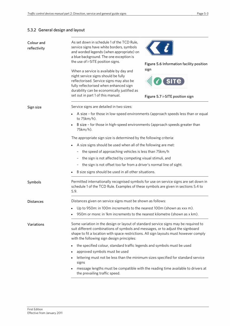
Traffic control devices manual part 2: Direction, service and general guide signs Page 5-3
First Edition Effective from January 2011
5.3.2 General design and layout
Colour and reflectivity
As set down in schedule 1 of the TCD Rule, service signs have white borders, symbols and worded legends (when appropriate) on a blue background. The one exception is the use of i-SITE position signs.
When a service is available by day and night service signs should be fully reflectorised. Service signs may also be fully reflectorised when enhanced sign durability can be economically justified as set out in part 1 of this manual.
Figure 5.6 Information facility position sign
Figure 5.7 i-SITE position sign
Sign size Service signs are detailed in two sizes:
• A size – for those in low-speed environments (approach speeds less than or equal to 75km/h).
• B size – for those in high-speed environments (approach speeds greater than 75km/h).
The appropriate sign size is determined by the following criteria:
• A size signs should be used when all of the following are met:
– the speed of approaching vehicles is less than 75km/h
– the sign is not affected by competing visual stimuli, and
– the sign is not offset too far from a driver’s normal line of sight.
• B size signs should be used in all other situations.
Symbols Permitted internationally recognised symbols for use on service signs are set down in schedule 1 of the TCD Rule. Examples of these symbols are given in sections 5.4 to 5.9.
Distances Distances given on service signs must be shown as follows:
• Up to 950m: in 100m increments to the nearest 100m (shown as xxx m). • 950m or more: in 1km increments to the nearest kilometre (shown as x km).
Variations Some variation in the design or layout of standard service signs may be required to suit different combinations of symbols and messages, or to adjust the signboard shape to fit a location with space restrictions. All sign layouts must however comply with the following sign design principles:
• the specified colour, standard traffic legends and symbols must be used • approved symbols must be used • lettering must not be less than the minimum sizes specified for standard service
signs • message lengths must be compatible with the reading time available to drivers at
the prevailing traffic speed.
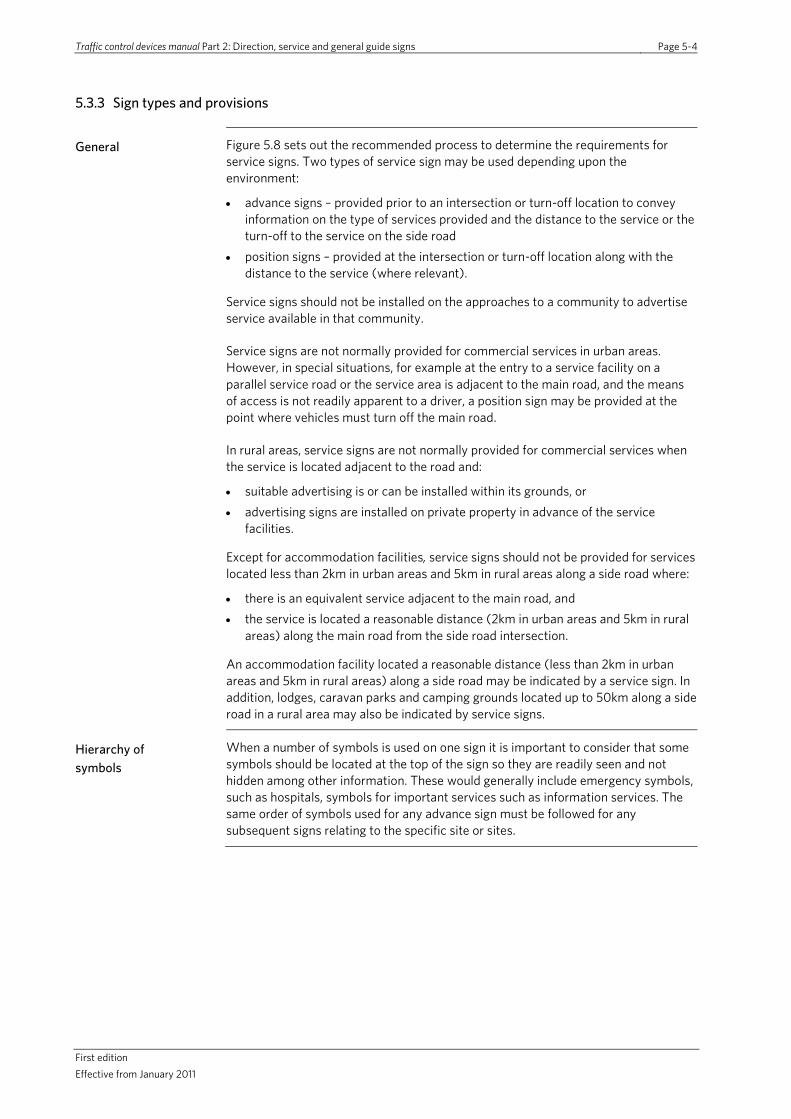
Traffic control devices manual Part 2: Direction, service and general guide signs Page 5-4
First edition Effective from January 2011
5.3.3 Sign types and provisions
General Figure 5.8 sets out the recommended process to determine the requirements for service signs. Two types of service sign may be used depending upon the environment:
• advance signs – provided prior to an intersection or turn-off location to convey information on the type of services provided and the distance to the service or the turn-off to the service on the side road
• position signs – provided at the intersection or turn-off location along with the distance to the service (where relevant).
Service signs should not be installed on the approaches to a community to advertise service available in that community.
Service signs are not normally provided for commercial services in urban areas. However, in special situations, for example at the entry to a service facility on a parallel service road or the service area is adjacent to the main road, and the means of access is not readily apparent to a driver, a position sign may be provided at the point where vehicles must turn off the main road.
In rural areas, service signs are not normally provided for commercial services when the service is located adjacent to the road and:
• suitable advertising is or can be installed within its grounds, or • advertising signs are installed on private property in advance of the service
facilities.
Except for accommodation facilities, service signs should not be provided for services located less than 2km in urban areas and 5km in rural areas along a side road where:
• there is an equivalent service adjacent to the main road, and • the service is located a reasonable distance (2km in urban areas and 5km in rural
areas) along the main road from the side road intersection.
An accommodation facility located a reasonable distance (less than 2km in urban areas and 5km in rural areas) along a side road may be indicated by a service sign. In addition, lodges, caravan parks and camping grounds located up to 50km along a side road in a rural area may also be indicated by service signs.
Hierarchy of symbols
When a number of symbols is used on one sign it is important to consider that some symbols should be located at the top of the sign so they are readily seen and not hidden among other information. These would generally include emergency symbols, such as hospitals, symbols for important services such as information services. The same order of symbols used for any advance sign must be followed for any subsequent signs relating to the specific site or sites.
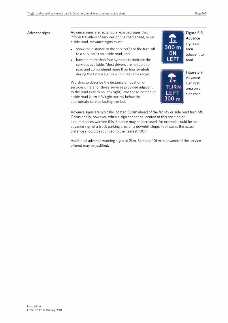
Traffic control devices manual part 2: Direction, service and general guide signs Page 5-5
First Edition Effective from January 2011
Advance signs Advance signs are rectangular-shaped signs that inform travellers of services on the road ahead, or on a side road. Advance signs must:
• show the distance to the service(s) or the turn-off to a service(s) on a side road, and
• have no more than four symbols to indicate the services available. Most drivers are not able to read and comprehend more than four symbols during the time a sign is within readable range.
Wording to describe the distance or location of services differs for those services provided adjacent to the road (xxx m on left/right), and those located on a side road (turn left/right xxx m) below the appropriate service facility symbol.
Figure 5.8 Advance sign rest area adjacent to road
Figure 5.9 Advance sign rest area on a side road
Advance signs are typically located 300m ahead of the facility or side road turn-off. Occasionally, however, when a sign cannot be located at this position or circumstances warrant this distance may be increased. An example could be an advance sign of a truck parking area on a downhill slope. In all cases the actual distance should be rounded to the nearest 100m.
Additional advance warning signs at 2km, 5km and 10km in advance of the service offered may be justified.

Traffic control devices manual part 2: Direction, service and general guide signs Page 5-6
First edition Effective from January 2011
Note: The two-step process indicated by the flowchart will ensure consistent and logical determination of the signing required for services. The summarised text in flowchart boxes should be read in conjunction with the full-service sign provision and sign requirements contained in section 7 of this manual.
Figure 5.8 Determining the use of service signs
RURAL AREAS
Approach speeds >65km/h?
Adequate notice given by advance and/or site signs?
Traffic safety problems likely in vicinity of service?
Advance signs should be provided
Advance signs are not normally required
Suitable signs located within the
service facility grounds?
Advance advertising signs
on private property?
Advance signing
Traffic safety problems likely in vicinity of service?
URBAN AREAS
Signs are not warranted
Is the service defined as a
service in definitions?
Will signs be considered as
advertising on the approaches to a
community?
Is the service located on a side road?
Is the service an accommodation
facility?
Is there an equivalent service
adjacent to the main road?
Signs maybe required
No
Yes
A position sign is not normally required
Is the service on a side road?
Is the service in an urban area?
Low-traffic speed area
(ie <65km/h)?
Existing advance signs?
A position sign
should be provided
Position signing
Step 1: Determine if service signing is warranted
No
Yes
Yes
No
No
No
YesYes No
Yes Yes
No No
NoNo
YesNo
YesYes
URBAN AND RURAL AREAS
Step 2: Determine which service signs should be provided
Yes
Yes
Yes
Yes No
No
No
No

Traffic control devices manual Part 2: Direction, service and general guide signs Page 5-7
First edition Effective from January 2011
Advance signs may be used in the following situations:
• When services are located in urban fringe areas and the 85th percentile traffic speed past the service exceeds 65km/h.
• When advertising or position signs at service facility locations do not provide adequate advance notice, ie signs are not visible to approaching
Figure 5.10 Combined services and tourist signs
drivers for sufficient time (approximately 10 seconds at the 85 percentile speed of traffic on the road) to allow the safe completion of any manoeuvres necessary to enter a service facility or to turn off into a side road.
• If safety problems are likely to be caused by vehicles suddenly stopping, slowing down, changing lanes or turning near entrances or side road turn-offs to service facilities.
Advance signs are not normally required in urban areas and on low-speed roads. Advertising signs at or within the grounds of service facilities should be sufficient in these situations.
When advance direction, service and tourist signs are required they should be located in the following manner:
• Advance service signs are located prior to advance direction signs. • When an advance tourist sign is also required, it should be combined with the
advance direction sign.
See also section 6.5.
Position signs Position signs should be used to indicate the actual location of the service facility or the side road turn-off to the service. They should be located at or directly opposite the point of entry to the service facility or side road turn-off to the facility. They should only be provided at the turn-off to a side road when the service located on the side road warrants service sign.
Figure 5.11 Position sign indicating a rest area
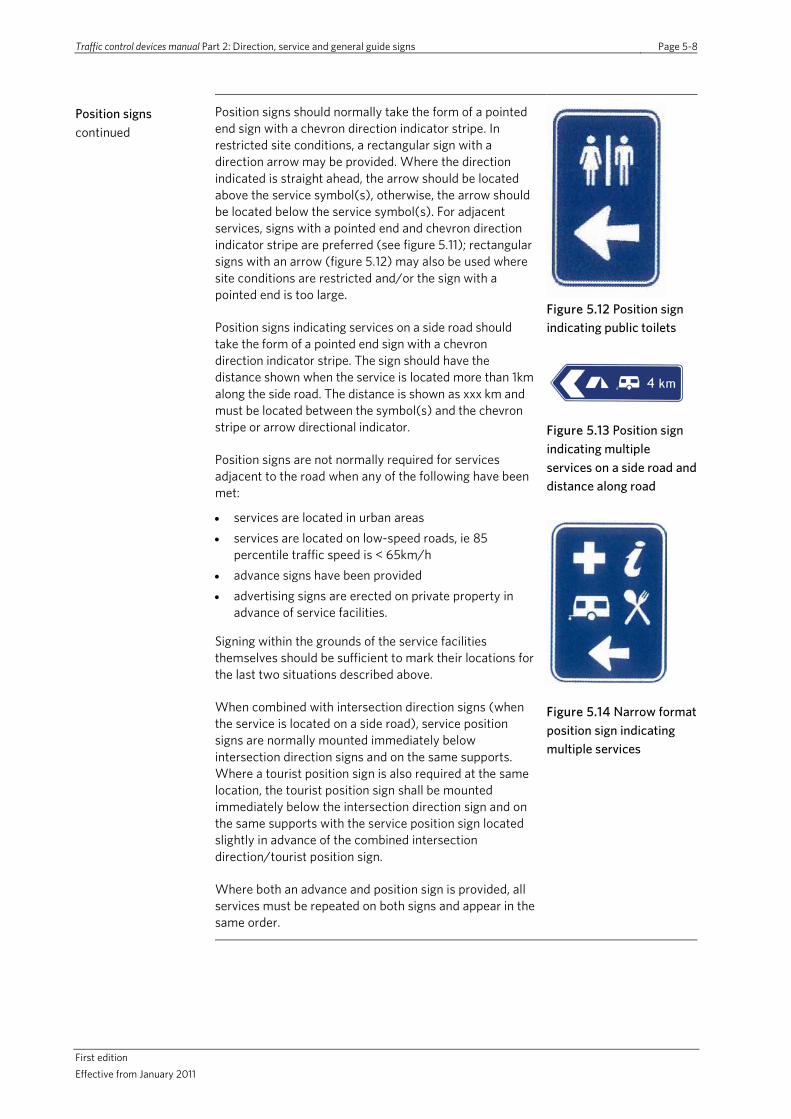
Traffic control devices manual Part 2: Direction, service and general guide signs Page 5-8
First edition Effective from January 2011
Position signs continued
Position signs should normally take the form of a pointed end sign with a chevron direction indicator stripe. In restricted site conditions, a rectangular sign with a direction arrow may be provided. Where the direction indicated is straight ahead, the arrow should be located above the service symbol(s), otherwise, the arrow should be located below the service symbol(s). For adjacent services, signs with a pointed end and chevron direction indicator stripe are preferred (see figure 5.11); rectangular signs with an arrow (figure 5.12) may also be used where site conditions are restricted and/or the sign with a pointed end is too large.
Position signs indicating services on a side road should take the form of a pointed end sign with a chevron direction indicator stripe. The sign should have the distance shown when the service is located more than 1km along the side road. The distance is shown as xxx km and must be located between the symbol(s) and the chevron stripe or arrow directional indicator.
Position signs are not normally required for services adjacent to the road when any of the following have been met:
• services are located in urban areas • services are located on low-speed roads, ie 85
percentile traffic speed is < 65km/h • advance signs have been provided • advertising signs are erected on private property in
advance of service facilities.
Signing within the grounds of the service facilities themselves should be sufficient to mark their locations for the last two situations described above.
When combined with intersection direction signs (when the service is located on a side road), service position signs are normally mounted immediately below intersection direction signs and on the same supports. Where a tourist position sign is also required at the same location, the tourist position sign shall be mounted immediately below the intersection direction sign and on the same supports with the service position sign located slightly in advance of the combined intersection direction/tourist position sign.
Where both an advance and position sign is provided, all services must be repeated on both signs and appear in the same order.
Figure 5.12 Position sign indicating public toilets
Figure 5.13 Position sign indicating multiple services on a side road and distance along road
Figure 5.14 Narrow format position sign indicating multiple services
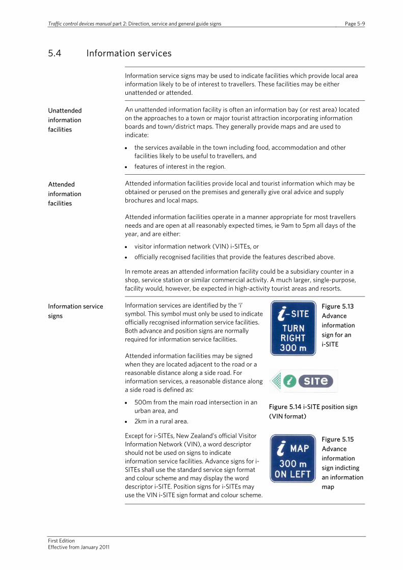
Traffic control devices manual part 2: Direction, service and general guide signs Page 5-9
First Edition Effective from January 2011
5.4 Information services
Information service signs may be used to indicate facilities which provide local area information likely to be of interest to travellers. These facilities may be either unattended or attended.
Unattended information facilities
An unattended information facility is often an information bay (or rest area) located on the approaches to a town or major tourist attraction incorporating information boards and town/district maps. They generally provide maps and are used to indicate:
• the services available in the town including food, accommodation and other facilities likely to be useful to travellers, and
• features of interest in the region.
Attended information facilities
Attended information facilities provide local and tourist information which may be obtained or perused on the premises and generally give oral advice and supply brochures and local maps.
Attended information facilities operate in a manner appropriate for most travellers needs and are open at all reasonably expected times, ie 9am to 5pm all days of the year, and are either:
• visitor information network (VIN) i-SITEs, or • officially recognised facilities that provide the features described above.
In remote areas an attended information facility could be a subsidiary counter in a shop, service station or similar commercial activity. A much larger, single-purpose, facility would, however, be expected in high-activity tourist areas and resorts.
Information service signs
Information services are identified by the ‘i’ symbol. This symbol must only be used to indicate officially recognised information service facilities. Both advance and position signs are normally required for information service facilities.
Attended information facilities may be signed when they are located adjacent to the road or a reasonable distance along a side road. For information services, a reasonable distance along a side road is defined as:
• 500m from the main road intersection in an urban area, and
• 2km in a rural area.
Except for i-SITEs, New Zealand’s official Visitor Information Network (VIN), a word descriptor should not be used on signs to indicate information service facilities. Advance signs for i-SITEs shall use the standard service sign format and colour scheme and may display the word descriptor i-SITE. Position signs for i-SITEs may use the VIN i-SITE sign format and colour scheme.
Figure 5.13 Advance information sign for an i-SITE
Figure 5.14 i-SITE position sign (VIN format)
Figure 5.15 Advance information sign indicting an information map

Traffic control devices manual Part 2: Direction, service and general guide signs Page 5-10
First edition Effective from January 2011
Information service signs continued
Where the type of information facility may not be obvious to travellers on the road, one of the word descriptors, eg centre, bay or map may be used.
Parking symbols should not normally be shown on signs including motorist information facilities because signing within the facility itself will normally indicate where to park. Where necessary within an information service facility, parking may be indicated by the use of a standard parking symbol on rectangular position sign.
Table 5.1 Information symbols
Type of information service Symbol
Information
Sign layout examples for information services facilities are shown in figures C-4 and C-5 in appendix C.
5.5 Rest areas
For road sign purposes, rest areas are roadside stopping places separated from the road. No specific facilities need be provided at rest areas but typically they can be expected to include a picnic table.
Rest areas can include provision for truck or truck/trailer parking, and may also provide a number of other facilities for the convenience of travellers such as information boards and toilets.
Where possible, truck parking areas should be provided on both sides of the road to prevent trucks from crossing the road and conflicting with on-coming vehicles.
Figure 5.16 Advance sign indicating rest area for heavy vehicles
Figure 5.17 Advance sign indicating rest area adjacent to road
Where truck parking can only be provided on one side of the road, consideration should be given to whether the truck parking area should be sign posted in both directions or only in the direction of vehicles approaching the parking area with the parking on the left side of the vehicle to discourage crossing movements. Truck parking areas should only be signed where the parking area has been specifically designed to accommodate truck movements and provide truck driver requirements.
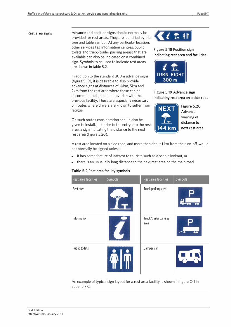
Traffic control devices manual part 2: Direction, service and general guide signs Page 5-11
First Edition Effective from January 2011
Rest area signs Advance and position signs should normally be provided for rest areas. They are identified by the tree and table symbol. At any particular location, other services (eg information centres, public toilets and truck/trailer parking areas) that are available can also be indicated on a combined sign. Symbols to be used to indicate rest areas are shown in table 5.2.
In addition to the standard 300m advance signs (figure 5.19), it is desirable to also provide advance signs at distances of 10km, 5km and 2km from the rest area where these can be accommodated and do not overlap with the previous facility. These are especially necessary on routes where drivers are known to suffer from fatigue.
On such routes consideration should also be given to install, just prior to the entry into the rest area, a sign indicating the distance to the next rest area (figure 5.20).
Figure 5.18 Position sign indicating rest area and facilities
Figure 5.19 Advance sign indicating rest area on a side road
Figure 5.20 Advance warning of distance to next rest area
A rest area located on a side road, and more than about 1 km from the turn-off, would not normally be signed unless:
• it has some feature of interest to tourists such as a scenic lookout, or • there is an unusually long distance to the next rest area on the main road.
Table 5.2 Rest area facility symbols
Rest area facilities Symbols Rest area facilities Symbols
Rest area
Truck parking area
Information
Truck/trailer parking area
Public toilets
Camper van
An example of typical sign layout for a rest area facility is shown in figure C-1 in appendix C.

Traffic control devices manual Part 2: Direction, service and general guide signs Page 5-12
First edition Effective from January 2011
5.6 Commercial services
Commercial services that may be signed along the road network include premises that provide the following services:
• motor fuel and/or repairs • meals and refreshments • public parking areas (operated on a commercial basis).
A service centre is a purpose-built establishment or a small cluster of facilities catering mainly for the needs of road users. As a minimum they should:
• incorporate motor fuel, refreshments, and public toilets • have direct access from an adjacent high standard road (preferably with a divided
carriageway) • provide adequate parking, • and be open 24 hours a day, all days of the year.
For the purpose of service signing, accommodation services, camping grounds and caravan parks are considered separately as accommodation services and are described in section 5.7.
Commercial services signs
Advance signs are not normally required for commercial services adjacent to two-lane roads. They may be necessary on divided roads and for some special situations when a position sign, or advertising signs within a site, are not readily visible to approaching drivers.
Figure 5.21 Advance sign indicating services on a side road
Position signs are also not normally required but they may be necessary on divided roads when a facility is located on the right-hand side of a divided road and it is not readily visible to drivers. In these cases a position sign could be used to indicate: • the gap in the median that road users should use to access the site, or • the direction back to the service facility along the other carriageway or service
road.
Service signs are not normally provided for commercial services on a side road unless:
• the service is located a reasonable distance, that is up to 2km in urban areas and up to 5km in rural areas along the side road, and
• the next equivalent service adjacent to the main road is significantly further away.
When a service centre is located in an area where the road has a posted speed limit of greater than 70km/h and no similar services are available in the immediate area, any service signing warranted for the facility may have the additional words service centre added. However, the use of the words service centre should only be added to normal or wide format signs. At restricted sites where a narrow sign format needs to be used there is usually insufficient sign width to accommodate the words on one line and the resultant sign would have a tall, unbalanced and visually unattractive layout.
The trading name of the commercial services should not be used on commercial services signs.

Traffic control devices manual part 2: Direction, service and general guide signs Page 5-13
First Edition Effective from January 2011
Commercial services signs continued
Motor fuel signs incorporating distances to the next fuel station may be provided. Normally these would not be used unless the distance between fuel stations exceed 100km. They should be located beyond the site of the previous fuel station.
The types of commercial services, and associated symbols, are shown in table 5.3.
Figure 5.22 Next fuel station advance advice
Table 5.3 Commercial service type symbols
Type of commercial services Symbols
Motor fuel
Motor fuel and repairs
Refreshments
Meals
Public parking area
An example of a typical sign layout for a commercial services facility is shown in figure C-2 in appendix C.
Traffic control devices manual Part 2: Direction, service and general guide signs Page 5-14
First edition Effective from January 2011
5.7 Accommodation services
The following criteria have been developed to help an RCA to determine whether an accommodation service is eligible for signs. Eligibility for signs does not entitle the placement of a sign on the road. Application for the installation of a sign must be made to the relevant RCA which, in making a decision, will include an assessment of the following criteria which have road safety and road efficiency implications.
To qualify for signing an accommodation service should demonstrate the following attributes:
• hold all relevant local authority and government licences and consents • be available to casual travellers throughout the year • must have clear street addresses, street directory or maps on their publicity
material such as brochures, stationery and also preferably a web site • have information about the facility available at nearby and regional visitor
information centres • be appropriately signed within the property line so that the facility is easily
identifiable by passing road users • have appropriately trained staff on site at all reasonable times.
Accommodation service signs
Accommodation services located adjacent to the main road should not normally be signed as signs within the facility property line should be visible to passing road users.
Accommodation facilities located within 2km along a side road in urban areas and 5km in rural may be signed (see also first bullet point below). If signed and located more than 1 km down a side road, the position sign should indicate a distance denoted in whole kilometres.
Advance signs are not normally necessary in urban areas but may be desirable in rural areas.
Where the route to an accommodation service requires road users to travel through several intersections, side road and main road signs should complement one another.
In some instances, in addition to an accommodation service symbol, word descriptors may be used to indicate the type or name of accommodation facility as set out below:
• Signs for a lodge, caravan park or camping ground located between 5 and 50km along a side road in a rural area may have a word description, or the name of the facility, eg remote area motor camp, Cassimir lodge, etc. below the accommodation symbol. The distance to the facility must also be shown on position sign(s). In no other case should the trading name of the facility be used.
• Signs displaying several service symbols, including the accommodation symbol, may have a single word descriptor positioned immediately below that symbol.
• Signs displaying only an accommodation symbols may have a single word descriptor positioned beneath the accommodation symbol.
• Word descriptors include titles such as lodge(s), cabin(s), guest house, YWCA, backpacker, B&B (the words bed and breakfast must not be used in full) and farm host.

Traffic control devices manual part 2: Direction, service and general guide signs Page 5-15
First Edition Effective from January 2011
Accommodation service signs continued
• Word descriptors should not be used where there are more than one different type of accommodation facility available along a side road, ie only the general accommodation symbol must be displayed.
• Words and name descriptors must be shown in series D capital lettering of an appropriate size.
Signs for youth hostel association (YHA) may use the YHA symbol instead of the standard accommodation symbol. Note: This is a copyrighted symbol and must only be used to indicate a YHA facility
Symbols used to denote different types of accommodation are shown in table 5.4.
Table 5.4 Accommodation service symbols
Type of accommodation services Symbols
Accommodation
Camping ground
Caravan park
Camping ground and caravan park
An example of a typical sign layout for an accommodation services facility is shown in figure C-3 in appendix C.

Traffic control devices manual Part 2: Direction, service and general guide signs Page 5-16
First edition Effective from January 2011
5.8 Other services
Other services are those local community services and facilities likely to be useful to travellers and can be indicated by symbols on service signs. These services include:
• 24-hour emergency medical services • public telephone • public toilets • public parking area including park and ride facilities • truck and truck/trailer parking area • airfields and airports • boat ramp • waste disposal points for campervans and caravans.
Symbols indicating the above services are shown in table 5.5.
Local community services and facilities which do not qualify as services should normally be indicated by signs in the general information/interest sign series (see section 8).
Other services signs Symbols should normally suffice to indicate these services and facilities on service signs. A word descriptor may occasionally be used immediately beneath some service symbols to further identify a particular type of service or facility.
Advance signs are not normally provided for local community services and facilities in urban areas. The following considerations should be taken into account when signing other services:
• Emergency medical services – when the service is available on a 24-hour basis and may include appropriate wording to show the type of service, eg ambulance, hospital, A & E, etc. The hospital name may also be included if there is more than one hospital in the area.
• Public telephone – when available for public use 24 hours a day, not readily visible from the road or located on a side road and not more than 500m from the main road in an urban area and 2km in a rural area. Distances should be shown on the sign in such circumstances.
• Public toilets – may be signed even when not available on a 24-hour basis. Where facilities cater for the disabled, a wheelchair symbol should be shown.
• Public parking area including park and ride facilities – for public parking areas. Signs should incorporate the P parking symbol, the appropriate type of transport system and a direction arrow or word message, such as location of the facility or suburb name, placed immediately below the P symbol. The legend park and ride may also be incorporated into signs at the entry points to the car park.
• Truck and truck/trailer parking – advice on truck-trailer parking signing is contained in section 5.4.
• Airfields, airports and helipads – airfield symbols may be used on single service position signs to indicate side road turn-offs, or the entry point, to public airfields, minor airports or helipads to act as an airport route indicator when the airport is not a destination indicated on normal guide signs. Major airports should be shown as destinations on guide signs as described in section 4.
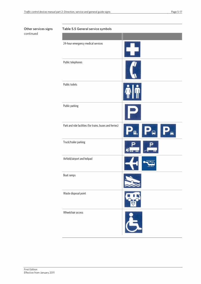
Traffic control devices manual part 2: Direction, service and general guide signs Page 5-17
First Edition Effective from January 2011
Other services signs continued
Table 5.5 General service symbols
24-hour emergency medical services
Public telephones
Public toilets
Public parking
Park and ride facilities (for trains, buses and ferries)
Truck/trailer parking
Airfield/airport and helipad
Boat ramps
Waste disposal point
Wheelchair access
Traffic control devices manual Part 2: Direction, service and general guide signs Page 5-18
First edition Effective from January 2011
5.9 Services in bypassed communities
Where a main road passes relatively close to a community offering services and where similar services are not available adjacent to the main road in that vicinity, it may be appropriate to sign the community and the services that are available.
Agreement on the type and extent of service signs will be necessary where different RCAs are responsible for managing the main road and access roads to the community. To warrant inclusion, services must be available at all reasonably expected times for the types of services provided.
Signing of services in bypassed communities
When a main road passes through a town or city, but not through its centre, an intersection direction sign showing the destination town/city centre/shopping area is usually sufficient to indicate the provision of normal services.
When there is doubt that the normal services will be available in a bypassed community, service sign may be provided, in conjunction with the normal guide sign.
The number of symbols should be kept to a minimum and no more than four symbols should be shown on any service sign.
Figure 5.8 Determining the use of service signs
Traffic control devices manual Part 2: Direction, service and general guide signs Page 6-1
First edition Effective from January 2011
6.0 Tourist signs
6.1 Principles and application
Tourist signs are advisory signs used to indicate tourist facilities and tourist ways to road users unfamiliar with the area.
Tourist signs alone however are not intended to fully meet all the desires and needs of road users. They merely form part of the overall traffic sign system working in conjunction with direction and route signs. Accordingly, tourist signs do not guide road users through the road network in the same manner as route signs as indicated in section 4. Tourist signs that identify a specific facility should only be used in the immediate vicinity of the tourist facility. For example, a specific tourist facility located in Taupo should not be signed in Auckland.
Tourist signs are similar to route signs in that they seek to:
• manage traffic on the road network by directing road users in a safe and efficient manner to a specific facility or along drives and/or routes of interest
• be user friendly, meaningful and informative to road users. This can best be achieved through the uniform and consistent application of tourist sign provision, design and placement on a national, regional and local basis
• provide the maximum amount of appropriate information while minimising the number of required signs.
In developing tourist sign strategies, it should be assumed travellers will undertake some preparation relating to routes and directions to a specific tourist site using road maps, tourist brochures or other material and increasingly will have other aids such as satellite navigation systems. Tourist signs are therefore primarily helping to reinforce tourism strategies and supporting tourist information made available through information services.
It is acknowledged and accepted that tourist signs are used to promote tourist facilities. However, they should not be used as advertising signs or for promotional purposes for individual tourist establishments. The approval of advertising signs to promote particular commercial activities is the responsibility of the appropriate RCA with permitted sign activities typically set down in the TA’s resource management plan or similar policy document. Roadside signs must not seek to address access issues resulting from poorly located businesses. There needs to be a balance in the types of signs used and providing for all road users. All road users need helpful guidance and direction to information and warnings of the environment ahead. Further information on ‘way finding’ for pedestrians can be referenced in the NZTA Pedestrian planning and design guide. Further information on advertising signs can be found in part 3 of this manual.

Traffic control devices manual Part 2: Direction, service and general guide signs Page 6-2
First edition Effective from January 2011
6.2 Tourist sign strategies and policies
The New Zealand Tourism Strategy 2015 prepared by the Ministry of Tourism sets out the vision for tourism in New Zealand in the future. An outcome of the Strategy relates to the delivery of a world-class visitor experience. An action specifically identified as part of the need to provide infrastructure to support the visitor experience at all stages of a journey includes the need to ensure that appropriate road signs are provided.
Regional sign schemes
While tourist signs are installed individually for a specific purpose, they should also conform to an overall route sign scheme through a regional or local area. This ensures appropriate tourist signs (sometimes in conjunction with other sign types) are used to guide visitors to the tourist destination in a logical progression through the road network and provide a uniform approach to the type of tourist signs used. Information services play an important part in the provision of information to support these strategies.
Where a themed tourist route (either within a region or between regions) exists or is planned, a corridor management plan setting out sign protocols and requirements should be developed to ensure consistency along the route.
Route plans for the installation and use of tourist signs may be based on the general guidance set down in the Austroads Guide to traffic management part 10 which includes some example plans. Such route plans should be based on the principles set down in this document as well as local and regional tourist sign strategies and policies.
Tourism groups should be represented on any committee developing regional tourist sign strategies and policies in order to ensure the needs and views of such interested stakeholders are fully taken into account. Regional sign schemes should be developed in discussion and agreement with adjacent regional authorities to ensure consistency of signing.
Tourism groups Tourism groups may include:
• regional tourism organisations (RTOs) – who link tourism operators, national tourism bodies and local and central government and have a responsibility of promoting their regions to visitors
• New Zealand Māori Tourism Council – who work to promote Māori tourism opportunities at national and regional level
• Tourism Industry Association New Zealand (TIA) – the industry’s main trade association, which represents a large number of organisations involved in tourism.
As part of any regional tourist sign strategy and policy, the needs and requirements of such groups will need to be balanced with those principles set down in section 6.1 as well as legal requirements.
In order to be fully effective, local RCA plans and policies governing the use of tourist signs should support the regional sign strategy.
Traffic control devices manual Part 2: Direction, service and general guide signs Page 6-3
First Edition Effective from January 2011
Road hierarchy As discussed, a strategic approach to tourist signing is needed, while noting that tourist signs are not intended to guide road users through the road network in the same manner as route signs. A consistent set of guidelines and policies for tourist signs throughout a region, regardless of whether the sign is located on a state highway or local road is therefore recommended.
6.3 Forms of tourist signs
Two main forms of tourist sign exist. Those that:
• identify specific tourist facilities through advance direction, position and information signs
• describe regional or local tourist ways which may be of interest to visitors and take the form of route indicator, advance direction, intersection direction and route confirmation signs.
Tourist facilities The term tourist facilities is used as the collective name for a wide range of locations that are of particular interest to tourists and visitors. They include:
• tourist features, such as geographical features, historical markers and scenic lookouts
• tourist establishments and clusters of commercially operated enterprises • major tourist attractions such as a notable area, region, town or resort.
Tourist and visitor information sites, such as staffed establishments or unattended roadside facilities specifically providing tourist information may be located with such tourist facilities. However, these information facilities are signed with service signs and are covered in section 5.4.
Further details on each of these types of tourist facilities are contained in section 6.5.
Touring routes The term tourist routes is used as a collective name for drives, routes and trails that may be of interest to tourists and visitors. Further details on touring routes are contained in section 4.
6.4 Tourist sign layout and details
6.4.1 Sign specifications
Specifications for tourist signs are available in the TCD Rule. The TCD manual section on sign specifications, currently under development, will provide sign design details. Published signs can be viewed on the NZTA’s website (www.nzta.govt.nz/resources/traffic-control-devices-manual/sign-specifications/).
6.4.2 General design and layout
Colour and reflectivity
As set down in schedule 1 of the TCD Rule, tourist signs have white borders, symbols and lettering on a brown background. Tourist signs should be reflectorised.
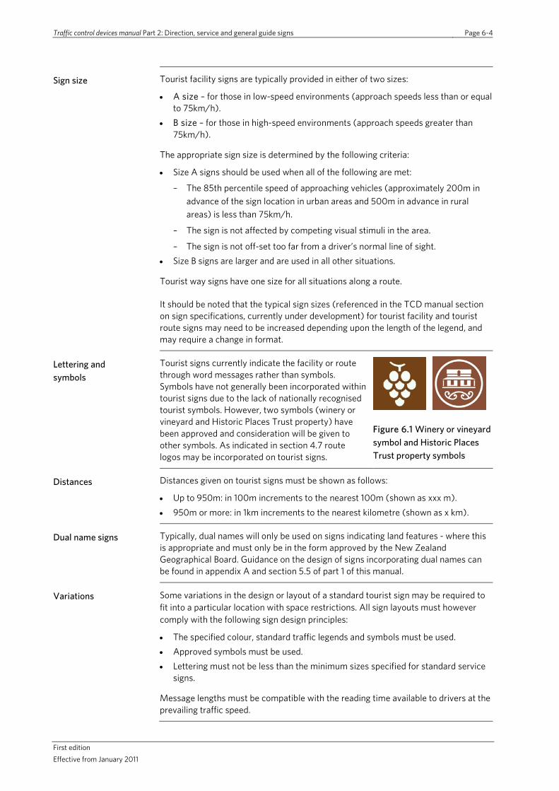
Traffic control devices manual Part 2: Direction, service and general guide signs Page 6-4
First edition Effective from January 2011
Sign size Tourist facility signs are typically provided in either of two sizes:
• A size – for those in low-speed environments (approach speeds less than or equal to 75km/h).
• B size – for those in high-speed environments (approach speeds greater than 75km/h).
The appropriate sign size is determined by the following criteria:
• Size A signs should be used when all of the following are met:
– The 85th percentile speed of approaching vehicles (approximately 200m in advance of the sign location in urban areas and 500m in advance in rural areas) is less than 75km/h.
– The sign is not affected by competing visual stimuli in the area.
– The sign is not off-set too far from a driver’s normal line of sight. • Size B signs are larger and are used in all other situations.
Tourist way signs have one size for all situations along a route.
It should be noted that the typical sign sizes (referenced in the TCD manual section on sign specifications, currently under development) for tourist facility and tourist route signs may need to be increased depending upon the length of the legend, and may require a change in format.
Lettering and symbols
Tourist signs currently indicate the facility or route through word messages rather than symbols. Symbols have not generally been incorporated within tourist signs due to the lack of nationally recognised tourist symbols. However, two symbols (winery or vineyard and Historic Places Trust property) have been approved and consideration will be given to other symbols. As indicated in section 4.7 route logos may be incorporated on tourist signs.
Figure 6.1 Winery or vineyard symbol and Historic Places Trust property symbols
Distances Distances given on tourist signs must be shown as follows:
• Up to 950m: in 100m increments to the nearest 100m (shown as xxx m). • 950m or more: in 1km increments to the nearest kilometre (shown as x km).
Dual name signs Typically, dual names will only be used on signs indicating land features - where this is appropriate and must only be in the form approved by the New Zealand Geographical Board. Guidance on the design of signs incorporating dual names can be found in appendix A and section 5.5 of part 1 of this manual.
Variations Some variations in the design or layout of a standard tourist sign may be required to fit into a particular location with space restrictions. All sign layouts must however comply with the following sign design principles:
• The specified colour, standard traffic legends and symbols must be used. • Approved symbols must be used. • Lettering must not be less than the minimum sizes specified for standard service
signs.
Message lengths must be compatible with the reading time available to drivers at the prevailing traffic speed.
Traffic control devices manual Part 2: Direction, service and general guide signs Page 6-5
First Edition Effective from January 2011
6.5 Eligibility for tourist signing
6.5.1 General
The following criteria have been developed to help an RCA to determine whether a tourist facility is eligible for tourist signs. Eligibility for tourist signs does not entitle the placement of a sign on the road. Application for the installation of a sign must be made to the relevant RCA which, in making a decision, will include an assessment of the following criteria which have road safety and road efficiency implications.
6.5.2 Criteria for tourist attraction signing
In order to qualify for tourist signing, the facility should:
a. have tourism as a core business activity
b. provide a tourism experience in addition to, or as part of, any commercial/retail activity (ie the experience must be for the purpose of education or demonstration of the manufacture of goods, or demonstration of crafts, as distinct from retail sales or other major use of the premises, and must be available on a regular basis at all times when the establishment is open)
c. have all relevant government and council licences and approvals to operate as a tourist facility
d. be open to the public without prior booking during the facility’s normal opening hours
e. be open on weekends and at least three other days of the week, plus public and school holidays
f. be open for a minimum of seven hours per day on the days the attraction is open
g. display clearly at the entry point the days and hours of opening
h. provide clean and conveniently located toilets, including those suitable for disabled users
i. provide adequate all-weather off-street parking, including dedicated spaces for disabled visitors, also for coaches and other large vehicles if such vehicles are ever expected
j. have an entrance to the above parking which is in a safe location and designed to appropriate standards for the amount of traffic using it and the traffic volume along the road
k. have information about the facility available at nearby and regional visitor information centres, with opening hours, admission prices, location and directions
l. promote the location and clear directions to the facility to visitors from outside the local area, utilising electronic and print media
m. be appropriately signed within the property line, including clear indication about parking, so that it is easily identifiable to passing road users
n. have appropriately trained visitor contact staff providing high standards of customer service, and
o. meet any specific criteria for the appropriate category of tourist attraction detailed in 6.5.3 below.

Traffic control devices manual Part 2: Direction, service and general guide signs Page 6-6
First edition Effective from January 2011
6.5.3 Specific criteria
Animal and bird parks, zoos and aquariums
To be eligible for signing, these facilities should meet all the criteria in 6.5.2 and provide:
a. supporting literature and interpretive materials for visitors, and
b. suitable protective fences/screens as appropriate to ensure the safety of visitors.
Art galleries, antique galleries and craft outlets
To be eligible for signing, these facilities should meet all the criteria in 6.5.2 and fulfil any two of the following specific criteria:
a. Feature a resident artist/craftsperson.
b. Display a production process, together with associated explanatory information.
c. Provide exhibition space of more than 50 square metres.
d. Arrange fresh exhibitions several times a year.
e. More than a third of the art or craft works on permanent display are from local or regional artists, or craftspeople.
Botanic gardens and arboretums
To be eligible for signing, these facilities should meet all the criteria in 6.5.2 except (l) and (m), and provide:
a. supporting literature and interpretive materials for visitors, and
b. maintain signs, markers and shelter appropriate for the expected use of the facility.
Museums and historic properties
To be eligible for signing, these facilities should meet all the criteria in 6.5.2 and:
a. be registered with the Historic Places Trust or other relevant affiliation if appropriate, and
b. provide supporting literature and interpretive materials for visitors which might be appropriately provided on a permanently displayed board.
National and regional parks, and geographical features (including lookouts)
To be eligible for signing, these facilities should, except as noted below, meet all the criteria in 6.5.2 except (l) and (m), and provide and maintain:
a. shelter and picnic facilities appropriate for the expected use of the facility, and
b. signs or markers to trail blaze pathways and exits as appropriate.
Note that a small unstaffed facility, eg a lookout, may not be expected to have infrastructure such as toilets or provide advertising or demonstrations.
Outdoor recreation, adventure sports and theme parks
To be eligible for signing, these facilities should meet all the criteria in 6.5.2 and provide appropriate warnings about the risks involved in participation in the activities provided as part of an approved health and safety policy.

Traffic control devices manual Part 2: Direction, service and general guide signs Page 6-7
First Edition Effective from January 2011
Primary and secondary industry-based attractions
These attractions include factories, manufacturing plants and agricultural operations. To be eligible for signing, these attractions should meet all the criteria in 6.5.2 except (f) and:
a. be open during normal business hours 5five days a week and preferably on weekends
b. provide guided tours to the general public at advertised times
c. display high-quality interpretive materials of the relevant agricultural or industrial process, and
d. where appropriate, provide sampling of the product available as part of the visitor experience.
Wineries and breweries
To be eligible for signing, these facilities should meet all the criteria in 6.5.2 and:
a. hold a current operating licence which permits sales direct to the public
b. have a purpose built facility for product tasting, and
c. Ii part of a regional group of facilities (eg a wine trail), provide maps of other similar facilities in the area.
Note that establishments meeting all criteria but only open on weekends and public holidays may apply for signing that is only displayed during opening hours.
Seasonal attractions
Attractions that close for part of the year may be eligible for tourist signs if:
a. during the part of the year they are operating, they meet all the relevant criteria in 6.5.2
b. the nearby and regional visitor information centres are notified and make available details of the restricted opening, and
c. any signs installed are closed, covered or removed during the times of the year when the establishment is closed.
6.6 Tourist facilities
6.6.1 Sign provision
General Each of the three categories of tourist facilities can have different types of signs:
• Tourist features – advance and position signs. • Tourist establishments and clusters of establishments – advance and position
signs. • Major tourist attractions – information and special signs.
Tourist facility signs must not be installed on the approaches to a community to advertise or indicate the facilities available in that community. Similarly, tourist facility signs should not be provided when the facility is located adjacent to a road. Suitable advertising signing (that complies with local plan requirements) on private property within the site itself or in advance of the facility entrance can, or has been installed.
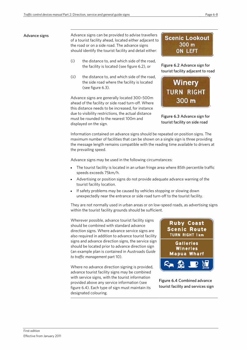
Traffic control devices manual Part 2: Direction, service and general guide signs Page 6-8
First edition Effective from January 2011
Advance signs Advance signs can be provided to advise travellers of a tourist facility ahead, located either adjacent to the road or on a side road. The advance signs should identify the tourist facility and detail either:
(i) the distance to, and which side of the road, the facility is located (see figure 6.2), or
(ii) the distance to, and which side of the road, the side road where the facility is located (see figure 6.3).
Advance signs are generally located 300–500m ahead of the facility or side road turn-off. Where this distance needs to be increased, for instance due to visibility restrictions, the actual distance must be rounded to the nearest 100m and displayed on the sign.
Figure 6.2 Advance sign for tourist facility adjacent to road
Figure 6.3 Advance sign for tourist facility on side road
Information contained on advance signs should be repeated on position signs. The maximum number of facilities that can be shown on a single sign is three providing the message length remains compatible with the reading time available to drivers at the prevailing speed.
Advance signs may be used in the following circumstances:
• The tourist facility is located in an urban fringe area where 85th percentile traffic speeds exceeds 75km/h.
• Advertising or position signs do not provide adequate advance warning of the tourist facility location.
• If safety problems may be caused by vehicles stopping or slowing down unexpectedly near the entrance or side road turn-off to the tourist facility.
They are not normally used in urban areas or on low-speed roads, as advertising signs within the tourist facility grounds should be sufficient.
Wherever possible, advance tourist facility signs should be combined with standard advance direction signs. Where advance service signs are also required in addition to advance tourist facility signs and advance direction signs, the service sign should be located prior to advance direction sign (an example plan is contained in Austroads Guide to traffic management part 10).
Where no advance direction signing is provided, advance tourist facility signs may be combined with service signs, with the tourist information provided above any service information (see figure 6.4). Each type of sign must maintain its designated colouring.
Figure 6.4 Combined advance tourist facility and services sign

Traffic control devices manual Part 2: Direction, service and general guide signs Page 6-9
First Edition Effective from January 2011
Position signs Position signs should be used to indicate the actual location of the tourist facility or the side road turn-off to the tourist facility. They should be located at, or directly opposite, the point of entry to the tourist facility or side road turn-off to the tourist facility.
All information shown on any advance signs should be repeated in the same order on the position signs.
Position signs should typically take the form of a pointed-end sign with chevron direction indicator stripe. However, a rectangular sign with direction arrow may also be used when the direction to be followed is not at right angles to the main road. Where position signs are used to indicate tourist facilities along a side road, distances should be provided when the tourist facility is greater than 1km along the side road. The distance should be shown as being to the nearest kilometre, and be positioned between the sign legend, and the chevron stripe or direction arrow.
Figure 6.5 Position sign indicating tourist facility when direction is not at right angles to main road
Figure 6.6 Position sign indicating tourist facility on a side road and distance along side road
Figure 6.7 Combined position sign and services sign on same posts
Position signs are not normally used to help identify tourist facilities adjacent to the main road when:
• the tourist facility is located in an urban or low-speed area • advance signs have been provided • advertising signs have been installed on private property in advance of the tourist
facility.
When used to indicate the position of a tourist facility on a side road, tourist services position signs should be used in conjunction with standard intersection direction signs. When combined with direction/guide signs, tourist position signs should normally be mounted immediately below intersection direction signs and be on the same supports. Where service signs are also required (in addition to the tourist and intersection direction signs), the intersection direction and tourist position sign should be combined on the same supports while the services position sign should be located prior to the combined sign, as a separate sign.
Where no intersection direction signing is provided, tourist position signs may be combined with service signs on the same posts, with the tourist information provided above any service information. Each type of sign must maintain its designated colouring.

Traffic control devices manual Part 2: Direction, service and general guide signs Page 6-10
First edition Effective from January 2011
6.6.2 Tourist features
For traffic sign purposes, tourist features are defined as geographical features that may be viewed, but not directly accessed, from the road or are sites of interest visited by tourists.
Geographical features viewed from the road
Geographical features be viewed from the road, but not actually visited, include mountain peaks, waterfalls, and named rock formations.
Figure 6.8 Position sign indicating a tourist facility
However, a feature should not be signed unless there is a suitable stopping place from which to view it..
Topographical or land features, as distinct from geographical features, such as rivers, creeks and hills. should be indicated by general interest signs and be signed as a place to stop and could coincide with the placement of rest areas (see section 8).
Sites of interest visited by tourists
Sites of interest visited by tourists may include:
• scenic lookouts or view points • historical sites (specifically identified by a marker or monument) or heritage trails • geographical features such as waterfalls, rock formations, caves, lakes, beaches • locations of cultural interest.
Tourist features should be of sufficient interest to warrant encouraging tourists to stop and visit the site, and should be identified in tourist brochures and guide books. Such sites will typically be well maintained and provide for the numbers of cars and tourist coaches expected to require parking with appropriate entry, exit and internal layout design. The parking will be at the site or at the beginning of a walking track associated with the tourist feature.
Sign types Tourist feature signs for sites of interest include advance and position type signs. The sign legend should include a basic description of the feature (and local name if required). Parking signs on the road are not normally required unless the parking site is located away from the actual tourist facility, for instance on the opposite side of the road.
An example of a typical sign layout for tourist feature sign is included in figure D-3 in appendix D.

Traffic control devices manual Part 2: Direction, service and general guide signs Page 6-11
First Edition Effective from January 2011
6.6.3 Tourist establishments and clusters
For traffic sign purposes, tourist establishments are commercially operated enterprises catering mainly for tourists (for which a charge may or may not be made). Tourist establishments must:
• have some interpretive value such as guided tours or working demonstrations (ie not just a retail facility)
• cater for, and be of genuine interest to, tourists, and • be considered a significant tourist attraction within the regional tourism strategy.
Tourist clusters are groups of tourist establishments of a similar nature in a smaller geographical area, such as a cluster of art and craft galleries. These should be defined within the regional tourism strategy and be part of an overall sign scheme.
Examples of tourist establishments include:
• museums, historic homes and gardens • tourist farms, fauna parks and zoos • wineries • craft centres, potteries and art galleries • theme parks and adventure sports facilities.
In order to justify a permanent tourist sign the establishment could be expected to:
• have information relating to its purpose, features, operating hours, etc readily available through the internet, information centres, brochures or other media
• be open to the general public at all reasonably expected times, ie six days or more each week throughout the entire year. Alternatively, the tourist establishment may be open for lesser periods where it can be demonstrated that local factors make year round operations inappropriate, for instance where winter conditions restrict its use.
Signs for establishments operating for only parts of the year should only be signed during the period when they are operating. If a permanently installed sign is used it should be concealed or covered up or be provided with a CLOSED supplementary plate when the establishment is not operating.
Sign types Tourist establishment signs include advance and position signs. The sign legend should include a basic description of the tourist establishment being identified, eg zoo, museum, winery or motor car museum. Where a significant tourist establishment is widely advertised by a trade name and publicly recognised by that name, the name may also be used on signs along with the generic description where appropriate, eg Southwards Car Museum.
Where there is a demand for more than four tourist establishments on a sign, similar types of establishment should be aggregated and indicated as a generic, plural description (eg wineries) instead of showing each individual establishment name.
Parking signs on the road are not normally required unless the parking site is located away from the actual tourist facility, for instance on the opposite side of the road.

Traffic control devices manual Part 2: Direction, service and general guide signs Page 6-12
First edition Effective from January 2011
Sign types continued
Advance and position signs should be provided for tourist establishments located on a side road.
For establishments located adjacent to the road, advance signs should only be provided when a potential road safety issue may exist as a result of vehicles stopping, slowing down or changing lanes in the vicinity of the establishment entrance. Position signs should only be provided where site access arrangements are complex or it is impracticable to provide suitably visible signs within the grounds of the establishment.
An example of a typical sign layout for a tourist facility is shown in figure D-4 in appendix D.
6.6.4 Tourist information facilities and visitor information centres
Tourist and visitor information sites may be in the form of either staffed visitor centres or unattended tourist facilities such as information bays containing boards, maps, etc.
Signs indicating tourist and visitor information sites are classified as services signs (ie with a blue background). Details on their use are contained in section 5.7.
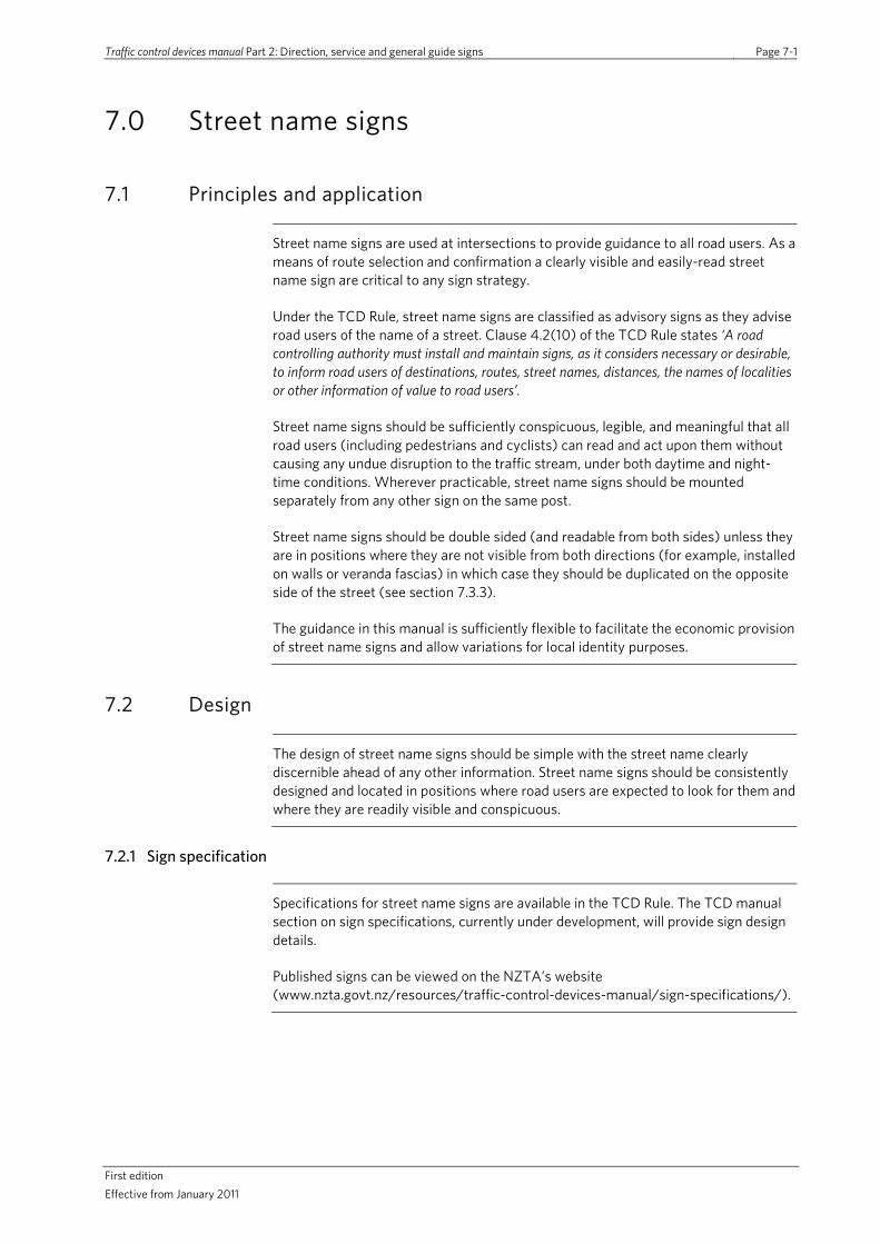
Traffic control devices manual Part 2: Direction, service and general guide signs Page 7-1
First edition Effective from January 2011
7.0 Street name signs
7.1 Principles and application
Street name signs are used at intersections to provide guidance to all road users. As a means of route selection and confirmation a clearly visible and easily-read street name sign are critical to any sign strategy.
Under the TCD Rule, street name signs are classified as advisory signs as they advise road users of the name of a street. Clause 4.2(10) of the TCD Rule states ‘A road controlling authority must install and maintain signs, as it considers necessary or desirable, to inform road users of destinations, routes, street names, distances, the names of localities or other information of value to road users’.
Street name signs should be sufficiently conspicuous, legible, and meaningful that all road users (including pedestrians and cyclists) can read and act upon them without causing any undue disruption to the traffic stream, under both daytime and night-time conditions. Wherever practicable, street name signs should be mounted separately from any other sign on the same post.
Street name signs should be double sided (and readable from both sides) unless they are in positions where they are not visible from both directions (for example, installed on walls or veranda fascias) in which case they should be duplicated on the opposite side of the street (see section 7.3.3).
The guidance in this manual is sufficiently flexible to facilitate the economic provision of street name signs and allow variations for local identity purposes.
7.2 Design
The design of street name signs should be simple with the street name clearly discernible ahead of any other information. Street name signs should be consistently designed and located in positions where road users are expected to look for them and where they are readily visible and conspicuous.
7.2.1 Sign specification
Specifications for street name signs are available in the TCD Rule. The TCD manual section on sign specifications, currently under development, will provide sign design details.
Published signs can be viewed on the NZTA’s website (www.nzta.govt.nz/resources/traffic-control-devices-manual/sign-specifications/).
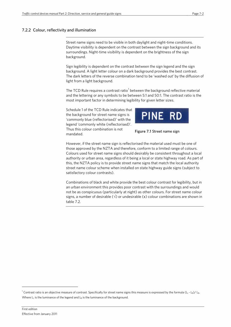
Traffic control devices manual Part 2: Direction, service and general guide signs Page 7-2
First edition Effective from January 2011
7.2.2 Colour, reflectivity and illumination
Street name signs need to be visible in both daylight and night-time conditions. Daytime visibility is dependent on the contrast between the sign background and its surroundings. Night-time visibility is dependent on the brightness of the sign background.
Sign legibility is dependent on the contrast between the sign legend and the sign background. A light letter colour on a dark background provides the best contrast. The dark letters of the reverse combination tend to be ‘washed out’ by the diffusion of light from a light background.
The TCD Rule requires a contrast ratio1 between the background reflective material and the lettering or any symbols to be between 5:1 and 50:1. The contrast ratio is the most important factor in determining legibility for given letter sizes.
Schedule 1 of the TCD Rule indicates that the background for street name signs is ‘commonly blue (reflectorised)’ with the legend ‘commonly white (reflectorised)’. Thus this colour combination is not mandated.
Figure 7.1 Street name sign
However, if the street name sign is reflectorised the material used must be one of those approved by the NZTA and therefore, conform to a limited range of colours. Colours used for street name signs should desirably be consistent throughout a local authority or urban area, regardless of it being a local or state highway road. As part of this, the NZTA policy is to provide street name signs that match the local authority street name colour scheme when installed on state highway guide signs (subject to satisfactory colour contrasts).
Combinations of black and white provide the best colour contrast for legibility, but in an urban environment this provides poor contrast with the surroundings and would not be as conspicuous (particularly at night) as other colours. For street name colour signs, a number of desirable (√) or undesirable (x) colour combinations are shown in table 7.2.
1 Contrast ratio is an objective measure of contrast. Specifically for street name signs this measure is expressed by the formula (LL - LB)/ LB.
Where LL is the luminance of the legend and LB is the luminance of the background.

Traffic control devices manual Part 2: Direction, service and general guide signs Page 7-3
First Edition Effective from January 2011
Table 7.2 Colours of sign background and street name showing desirable (√) and undesirable (x) colour combinations Source: AS1742.5:1997 Manual of uniform traffic control devices, part 5 Street name and community facility name signs (AS1742.5).
Legend colour Background colour
White Yellow Standard green
Blue Brown Black
White - x (3) √ (5) √ (5) x (2, 4) x (2, 4)
Yellow x (3) - x (2) x (2, 3) x (2, 4) x (4)
Standard green √ (1) √ (1) - x (3) x (3) x (3)
Blue √ (1) √ (1) x (3) - x (3) x (3)
Brown √ (1) √ (1) x (3) x (3) - x (3)
Black √ (1) √ (1) x (3) x (3) -
Notes: 1 Legend must be non-reflectorised.
2. Not suitable for street name.
3. Inadequate contrast between colours.
4. Sign will not be sufficiently conspicuous.
5. Background must be reflectorised.
To obtain sufficient brightness to be effective at night, especially at maximum mounting heights, street name signs must be retro-reflective (TCD rule requirement), and may be internally illuminated or floodlit. The latter two are generally impractical or excessively expensive. Internally illuminated signs shall be as visible and legible from a distance as signs using retroreflective material, and the light output should not be so high as to cause glare.
Street name signs are typically mounted above the optimum height to be illuminated by vehicle headlights. Normal street lighting is not sufficient to illuminate street name signs for motorists but is often useful to enable the signs to be read by pedestrians. For these reasons the selection of the correct class of sign reflective material is critical.
Further information on types of sheeting and reflectivity are included in section 8, part 1 of this manual..
7.2.3 Lettering
Some typefaces are harder to read than others. Signs which have lettering with upper and lower case characters are easier to read than lettering in capitals only.
The TCD Rule notes that the main text on street name signs should be a minimum height of 100mm in Transport Medium lettering and street numbers should be a minimum of 50mm Transport Medium or an approved transport font.
Table 7.4 shows the recommended letter heights for street name signs (incorporating typical current RCA street name practice).

Traffic control devices manual Part 2: Direction, service and general guide signs Page 7-4
First edition Effective from January 2011
Table 7.4 Recommended street name sign letter height
Street name sign location Letter height
Major roads 150mm (120mm absolute minimum)
Other roads 125mm (100mm absolute minimum)
Notes: Lettering must be an approved transport font.
7.2.4 Permitted information
Abbreviations Standard abbreviations for the descriptors street, road, etc are given in table 7.5. These abbreviations should have lettering of the same size and type as the street name. Except for signs with upper and lower case lettering, the second and subsequent letters of any abbreviation or label may be half the height of other letters on the sign. See figure 1 for examples of acceptable sign layouts.
Table 7.5 Standard abbreviations for road descriptors
Descriptor Abbreviation Descriptor Abbreviation
Arcade Arc Highway Hwy
Avenue Ave Junction Jnc
Boulevard Bvd Lane Lane*
Brae Br Motorway Mwy
Chase Ch Parade Pde
Circuit Cct Place Pl
Circle Cir Plaza Pl
Close Cl Promenade Prm
Corner Cnr Quay Quay*
Court Ct Road Rd
Crescent Cr Square Sq
Drive Dr Street St
Esplanade Esp Terrace Tce
Expressway Expwy Walk Wk
Gardens Gdn Way Way*
Grove Gr
* Lane, quay, way should not be abbreviated unless the resulting sign would exceed 1200mm in length.
Retroreflective chevrons or arrows (refer to the TCD Rule for the minimum size of the chevron) at either end of the legend can be used as an additional indicator for road users. They are recommended on low-mounted signs on medians or traffic islands, and in situations where the orientation of the street name sign does not clearly convey the direction of the street to which it refers.
To aid conspicuity and readability of street name signs it is recommended the lettering be no closer to the outside edge of the sign than 50 percent of the letter height. A 50mm border of background colour above and below the legend should be considered the absolute minimum when used on street name signs.
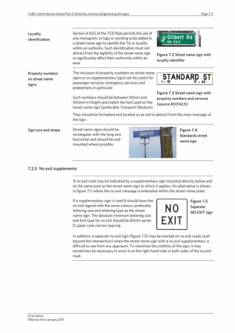
Traffic control devices manual Part 2: Direction, service and general guide signs Page 7-5
First Edition Effective from January 2011
Locality identification
Section 4.4(5) of the TCD Rule permits the use of one monogram, or logo or wording to be added to a street name sign to identify the TA or locality within an authority. Such identification must not detract from the legibility of the street name sign or significantly affect their uniformity within an area.
Figure 7.2 Street name sign with locality identifier
Property numbers on street name signs
The inclusion of property numbers on street name signs or on supplementary signs can be useful for passenger services, emergency services and pedestrians in particular.
Such numbers should be between 50mm and 100mm in height and match the font used on the street name sign (preferably Transport Medium).
Figure 7.3 Street name sign with property numbers and services (source AS1742.5)
They should be formatted and located so as not to detract from the main message of the sign.
Sign size and shape Street name signs should be rectangular with the long axis horizontal and should be end-mounted where possible.
Figure 7.4 Standards street name sign
7.2.5 No exit supplements
A no exit road may be indicated by a supplementary sign mounted directly below and on the same post as the street name sign to which it applies. An alternative is shown in figure 7.2 where the no exit message is embodied within the street name plate.
If a supplementary sign is used it should have the no exit legend with the same colours, preferably lettering size and lettering type as the street name sign. The absolute minimum lettering size and font type for no exit should be 60mm series D upper case narrow spacing.
Figure 7.5 Separate NO EXIT sign
In addition, a separate no exit sign (figure 7.5) may be erected on no exit roads (just beyond the intersection) when the street name sign with a no exit supplementary is difficult to see from any approach. To maximise the visibility of the sign, it may sometimes be necessary to erect it on the right-hand side or both sides of the no exit road.

Traffic control devices manual Part 2: Direction, service and general guide signs Page 7-6
First edition Effective from January 2011
7.2.6 Rapid numbers (rural address property identification)
Rapid numbers are used to identify property locations in rural areas and are particularly useful for emergency services.
RCAs have their own standards and bylaws relating to rural property numbering and these should be adhered to, using this document as a guide. The rapid number should be 80mm minimum height and should be reflectorised with contrasting background (commonly used
Figure 7.6 Rapid number ‘263’
colours: white numerals with blue reflectorised background or red numerals with white unreflectorised background).
Rapid numbers are generally fixed parallel to the road in a prominent position close to the vehicle entrance (eg letterbox, gatepost or fence).
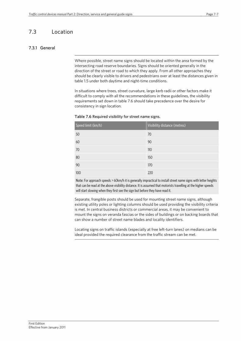
Traffic control devices manual Part 2: Direction, service and general guide signs Page 7-7
First Edition Effective from January 2011
7.3 Location
7.3.1 General
Where possible, street name signs should be located within the area formed by the intersecting road reserve boundaries. Signs should be oriented generally in the direction of the street or road to which they apply. From all other approaches they should be clearly visible to drivers and pedestrians over at least the distances given in table 1.5 under both daytime and night-time conditions.
In situations where trees, street curvature, large kerb radii or other factors make it difficult to comply with all the recommendations in these guidelines, the visibility requirements set down in table 7.6 should take precedence over the desire for consistency in sign location.
Table 7.6 Required visibility for street name signs.
Speed limit (km/h) Visibility distance (metres)
50 70
60 90
70 110
80 150
90 170
100 220
Note: For approach speeds > 60km/h it is generally impractical to install street name signs with letter heights that can be read at the above visibility distance. It is assumed that motorists travelling at the higher speeds will start slowing when they first see the sign but before they have read it.
Separate, frangible posts should be used for mounting street name signs, although existing utility poles or lighting columns should be used providing the visibility criteria is met. In central business districts or commercial areas, it may be convenient to mount the signs on veranda fascias or the sides of buildings or on backing boards that can show a number of street name blades and locality identifiers.
Locating signs on traffic islands (especially at free left-turn lanes) on medians can be ideal provided the required clearance from the traffic stream can be met.
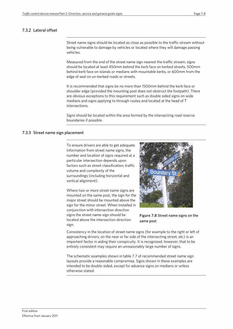
Traffic control devices manual Part 2: Direction, service and general guide signs Page 7-8
First edition Effective from January 2011
7.3.2 Lateral offset
Street name signs should be located as close as possible to the traffic stream without being vulnerable to damage by vehicles or located where they will damage passing vehicles.
Measured from the end of the street name sign nearest the traffic stream, signs should be located at least 450mm behind the kerb face on kerbed streets, 500mm behind kerb face on islands or medians with mountable kerbs, or 600mm from the edge of seal on un-kerbed roads or streets.
It is recommended that signs be no more than 1500mm behind the kerb face or shoulder edge (provided the mounting post does not obstruct the footpath). There are obvious exceptions to this requirement such as double sided signs on wide medians and signs applying to through routes and located at the head of T intersections.
Signs should be located within the area formed by the intersecting road reserve boundaries if possible.
7.3.3 Street name sign placement
To ensure drivers are able to get adequate information from street name signs, the number and location of signs required at a particular intersection depends upon factors such as street classification, traffic volume and complexity of the surroundings (including horizontal and vertical alignment).
Where two or more street name signs are mounted on the same post, the sign for the major street should be mounted above the sign for the minor street. When installed in conjunction with intersection direction signs the street name sign should be located above the intersection direction sign.
Figure 7.8 Street name signs on the same post
Consistency in the location of street name signs (for example to the right or left of approaching drivers, on the near or far side of the intersecting street, etc) is an important factor in aiding their conspicuity. It is recognised, however, that to be entirely consistent may require an unreasonably large number of signs.
The schematic examples shown in table 7.7 of recommended street name sign layouts provide a reasonable compromise. Signs shown in these examples are intended to be double-sided, except for advance signs on medians or unless otherwise stated.

Traffic control devices manual Part 2: Direction, service and general guide signs Page 7-9
First Edition Effective from January 2011
Table 7.7 Recommended street name sign layouts
T intersections of: (a) minor road with minor road, or (b) minor road with undivided major road
The name of the side road should be provided at position (1).
If visibility of the minor side road street name sign is limited or the through road is a major road, an additional street name at position (2) may be installed.
When the through road is an undivided major/arterial and the visibility is restricted an additional street name sign may also be provided at position (3).
Signing the name of the through road is optional at position (2).
T intersections of divided road with major side road
The divided road name and the minor street name should always be provided at positions (1). If visibility is limited, additional street names signs should be installed at position (2) or (3).
For major side roads, advance street name signs or street name signs incorporated into advance direction guide signs should be provided at positions (4). Note position (4) sign location will depend on the width of median island and if there is insufficient width, the sign will need be mounted on the left-hand side approach to intersection.
T intersections of two divided roads
Signs for both divided roads should be provided at positions (1). On multi-lane approaches, an additional side road sign may also be provided at position (2). If the name of the through route changes an additional sign may be provided at position (3).
Advance street name signs or signs incorporated into advance direction guide signs should be provided at position (4). Note position (4) sign location will depend on width of median island and if there is insufficient width the sign will need be mounted on the left-hand side approach to intersection.
Cross intersections of: (a) minor road with minor road, (b) minor road with major road, and (c) cross intersections of undivided major roads
A street name signs showing the name of each road at position (1) is generally sufficient.
If the visibility of these signs is limited, additional street name signs at position (2) may be installed.
If the names of one or more of the roads change, an additional street name sign or signs should be provided at position (2).
If the major road has a guide sign system that shows the through road name (or route number) of the major road on the intersection destination signs, then a street name sign for the major route is optional and is not normally installed.
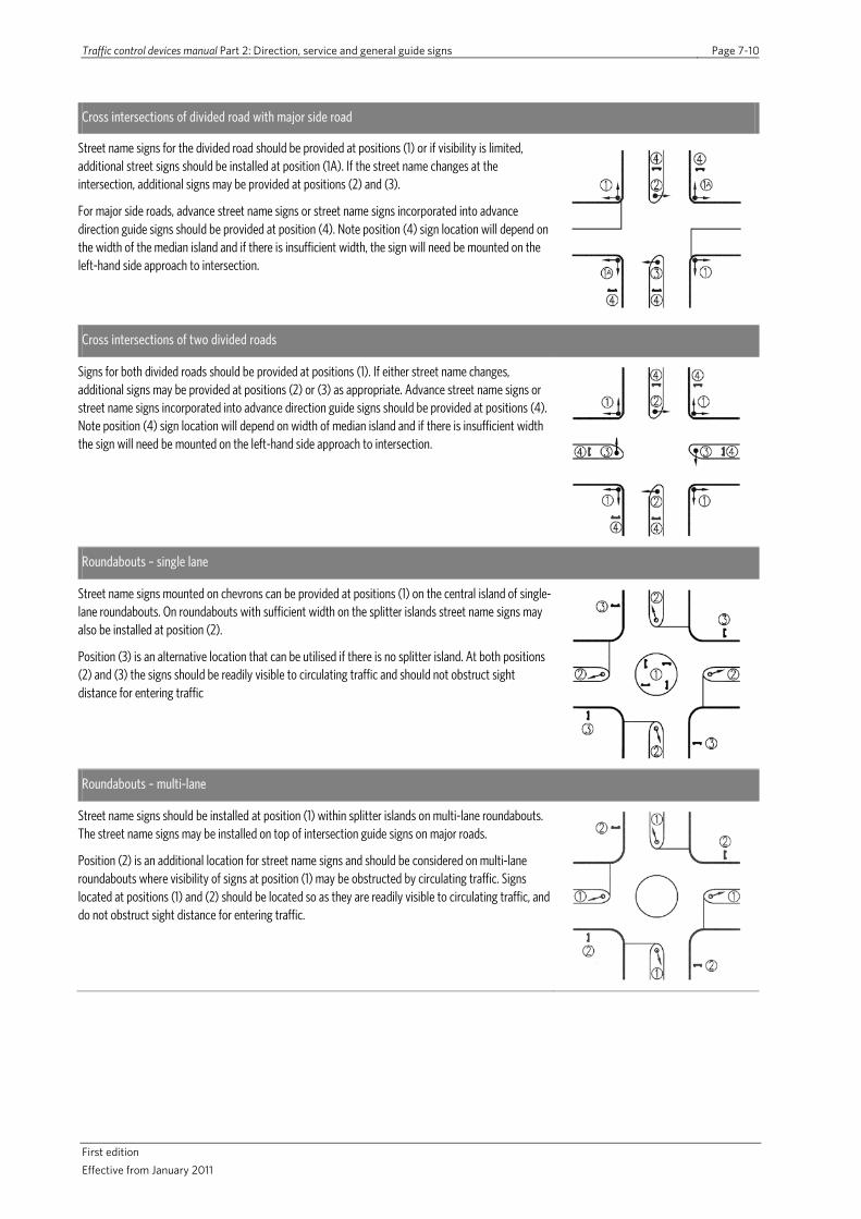
Traffic control devices manual Part 2: Direction, service and general guide signs Page 7-10
First edition Effective from January 2011
Cross intersections of divided road with major side road
Street name signs for the divided road should be provided at positions (1) or if visibility is limited, additional street signs should be installed at position (1A). If the street name changes at the intersection, additional signs may be provided at positions (2) and (3).
For major side roads, advance street name signs or street name signs incorporated into advance direction guide signs should be provided at position (4). Note position (4) sign location will depend on the width of the median island and if there is insufficient width, the sign will need be mounted on the left-hand side approach to intersection.
Cross intersections of two divided roads
Signs for both divided roads should be provided at positions (1). If either street name changes, additional signs may be provided at positions (2) or (3) as appropriate. Advance street name signs or street name signs incorporated into advance direction guide signs should be provided at positions (4). Note position (4) sign location will depend on width of median island and if there is insufficient width the sign will need be mounted on the left-hand side approach to intersection.
Roundabouts – single lane
Street name signs mounted on chevrons can be provided at positions (1) on the central island of single-lane roundabouts. On roundabouts with sufficient width on the splitter islands street name signs may also be installed at position (2).
Position (3) is an alternative location that can be utilised if there is no splitter island. At both positions (2) and (3) the signs should be readily visible to circulating traffic and should not obstruct sight distance for entering traffic
Roundabouts – multi-lane
Street name signs should be installed at position (1) within splitter islands on multi-lane roundabouts. The street name signs may be installed on top of intersection guide signs on major roads.
Position (2) is an additional location for street name signs and should be considered on multi-lane roundabouts where visibility of signs at position (1) may be obstructed by circulating traffic. Signs located at positions (1) and (2) should be located so as they are readily visible to circulating traffic, and do not obstruct sight distance for entering traffic.
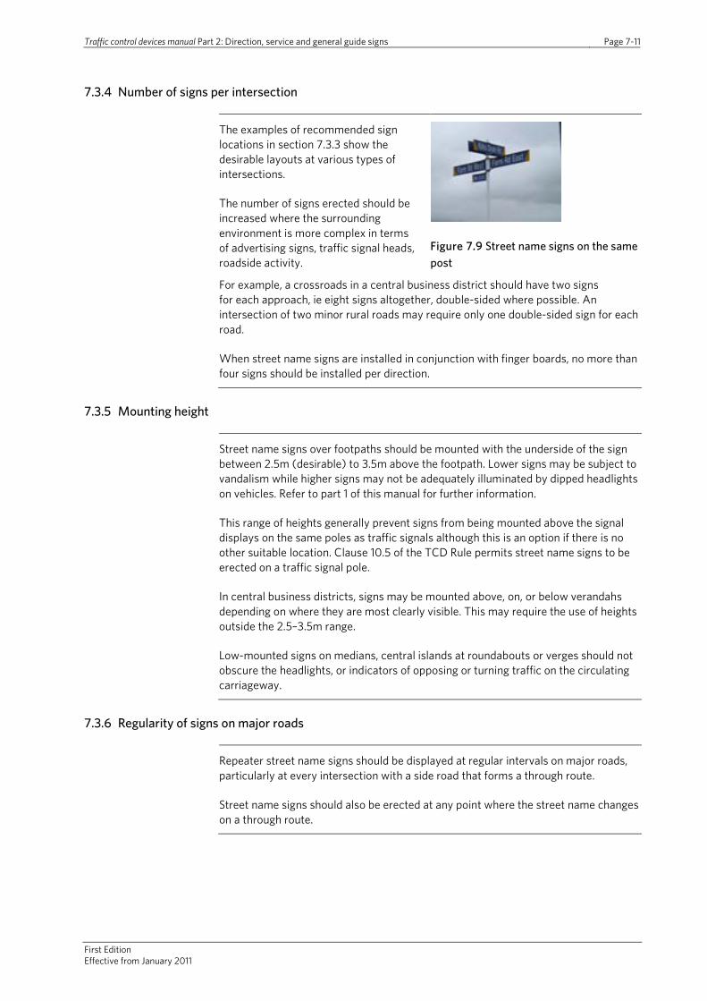
Traffic control devices manual Part 2: Direction, service and general guide signs Page 7-11
First Edition Effective from January 2011
7.3.4 Number of signs per intersection
The examples of recommended sign locations in section 7.3.3 show the desirable layouts at various types of intersections.
The number of signs erected should be increased where the surrounding environment is more complex in terms of advertising signs, traffic signal heads, roadside activity.
Figure 7.9 Street name signs on the same post
For example, a crossroads in a central business district should have two signs for each approach, ie eight signs altogether, double-sided where possible. An intersection of two minor rural roads may require only one double-sided sign for each road.
When street name signs are installed in conjunction with finger boards, no more than four signs should be installed per direction.
7.3.5 Mounting height
Street name signs over footpaths should be mounted with the underside of the sign between 2.5m (desirable) to 3.5m above the footpath. Lower signs may be subject to vandalism while higher signs may not be adequately illuminated by dipped headlights on vehicles. Refer to part 1 of this manual for further information.
This range of heights generally prevent signs from being mounted above the signal displays on the same poles as traffic signals although this is an option if there is no other suitable location. Clause 10.5 of the TCD Rule permits street name signs to be erected on a traffic signal pole.
In central business districts, signs may be mounted above, on, or below verandahs depending on where they are most clearly visible. This may require the use of heights outside the 2.5–3.5m range.
Low-mounted signs on medians, central islands at roundabouts or verges should not obscure the headlights, or indicators of opposing or turning traffic on the circulating carriageway.
7.3.6 Regularity of signs on major roads
Repeater street name signs should be displayed at regular intervals on major roads, particularly at every intersection with a side road that forms a through route.
Street name signs should also be erected at any point where the street name changes on a through route.

Traffic control devices manual Part 2: Direction, service and general guide signs Page 7-12
First edition Effective from January 2011
7.3.7 Advance street name signs at major intersections
Advance street name signs are desirable for intersecting major roads particularly where there is a central median. At some locations the advance street name sign may be included on the advance direction signs (refer to section 4) for the intersection. These types of signs should also be considered within the overall sign scheme for the area. Refer to section 1.4 for further information.
Advance street name signs should be erected in advance of the intersection by at least the distances shown in table 7.7.
Table 7.7 Location of advance street name signs in relation to intersections
Speed limit (km/h) Desirable minimum distance in advance of intersections (m)
50 85
60 100
70 120
80 140
100 180
These distances may need to be varied, for instance where a minor side street exists between the sign and the intersection of the named major road.
On major roads where there are one or two lanes in each direction and a raised central median, low-mounted signs on the central median may be used as an advance warning. Where there are three or more lanes in each direction or there is no raised central median, overhead street name sign installations may be necessary.
Traffic control devices manual Part 2: Direction, service and general guide signs Page 8-1
First edition Effective from January 2011
8.0 General interest signs
8.1 Principles and application
General interest signs are a subset of general information signs. They are used to provide road users with information relating to the location of a range of local services and facilities. General interest signs however should not be used to sign services (such as public toilets) or tourist facilities. In addition, the use of street name signs should take precedence over the use of general interest signs.
By their very nature, general interest signs tend to be stand-alone signs not requiring advance signing in the form of route, guide, tourist or service signs. They provide guidance and information relating to a specific location of interest rather than simply general information relating to road user requirements and advice (eg road condition advisory signs, no exit, heavy traffic bypass, passing lane, stock effluent).
Local services and facilities (including commercial establishments) will request local authorities sign or direct road users to their particular location. Given the large number of facilities that could be signed over a range of locations, the potential exists for a proliferation of signs to be installed leading to information overload for road users. This would reduce the effectiveness of all signs as road users attempt to scan the information provided. In order to address such concerns RCAs should set out clear policies relating to sign sites of general interest. Those services or facilities seeking to be identified should be first encouraged to ensure they provide clear street addresses, street directory references or maps on their publicity material such as brochures, stationery or website and that information about them is available at information centres.
Road users can be expected to have undertaken some preparation relating to the site or destination of interest, for instance in terms of its address. Subject to a local authority providing street name signs in accordance with the recommendations in this Manual, and community facilities or public amenities giving their address, road users should be able to reach their destination without excessive signing.
For facilities that generate large amounts of traffic, such as airports, ports, major sporting venues, standard direction and guide signs as described in sections 4, 5 and 6 should be used.
Subject to the form of general interest sign and its locations, designs should take into account the needs of all road users including motorists, bus or coach drivers, pedestrians, cyclists and equestrians. This is particularly true where pedestrian and cycle routes follow a different path to a motor-vehicle route.
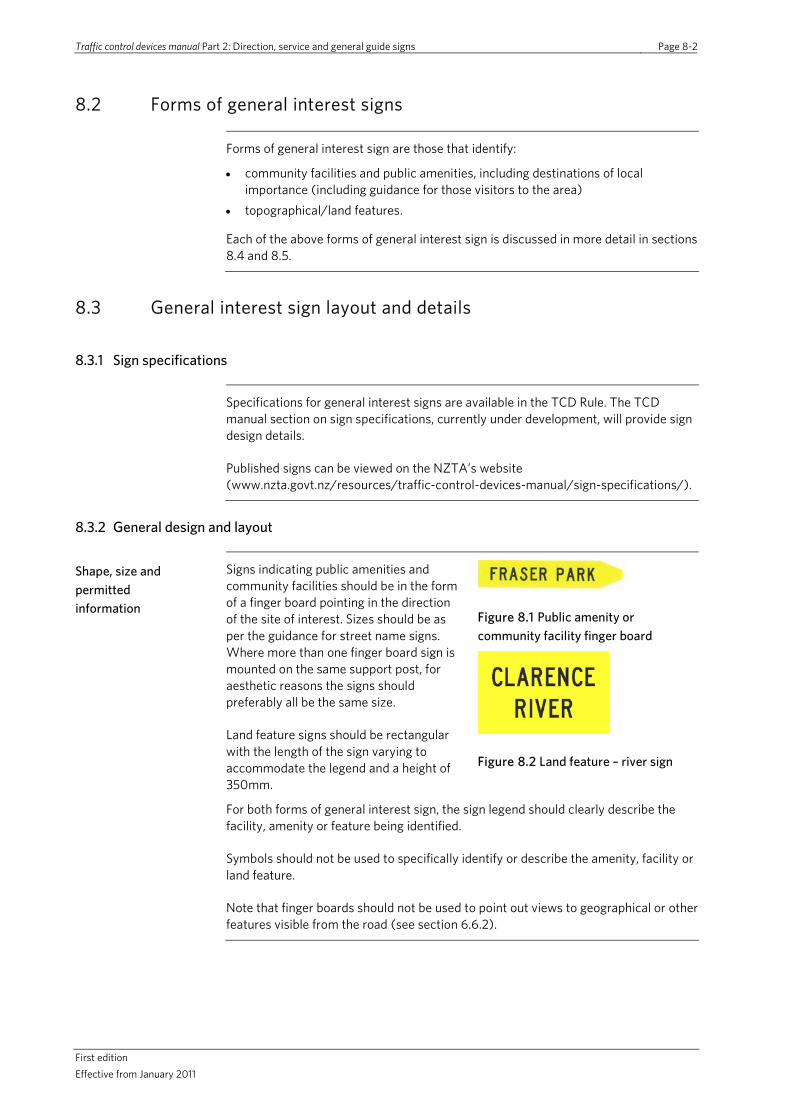
Traffic control devices manual Part 2: Direction, service and general guide signs Page 8-2
First edition Effective from January 2011
8.2 Forms of general interest signs
Forms of general interest sign are those that identify:
• community facilities and public amenities, including destinations of local importance (including guidance for those visitors to the area)
• topographical/land features.
Each of the above forms of general interest sign is discussed in more detail in sections 8.4 and 8.5.
8.3 General interest sign layout and details
8.3.1 Sign specifications
Specifications for general interest signs are available in the TCD Rule. The TCD manual section on sign specifications, currently under development, will provide sign design details.
Published signs can be viewed on the NZTA’s website (www.nzta.govt.nz/resources/traffic-control-devices-manual/sign-specifications/).
8.3.2 General design and layout
Shape, size and permitted information
Signs indicating public amenities and community facilities should be in the form of a finger board pointing in the direction of the site of interest. Sizes should be as per the guidance for street name signs. Where more than one finger board sign is mounted on the same support post, for aesthetic reasons the signs should preferably all be the same size.
Land feature signs should be rectangular with the length of the sign varying to accommodate the legend and a height of 350mm.
Figure 8.1 Public amenity or community facility finger board
Figure 8.2 Land feature – river sign
For both forms of general interest sign, the sign legend should clearly describe the facility, amenity or feature being identified.
Symbols should not be used to specifically identify or describe the amenity, facility or land feature.
Note that finger boards should not be used to point out views to geographical or other features visible from the road (see section 6.6.2).
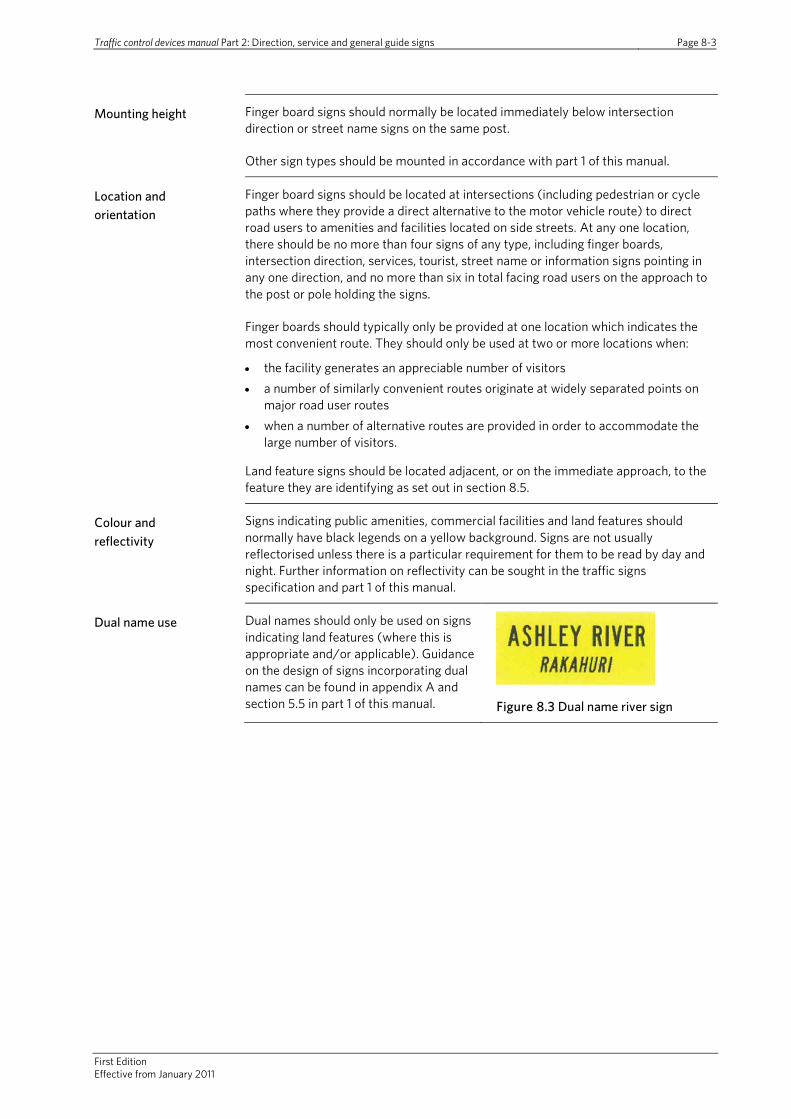
Traffic control devices manual Part 2: Direction, service and general guide signs Page 8-3
First Edition Effective from January 2011
Mounting height Finger board signs should normally be located immediately below intersection direction or street name signs on the same post.
Other sign types should be mounted in accordance with part 1 of this manual.
Location and orientation
Finger board signs should be located at intersections (including pedestrian or cycle paths where they provide a direct alternative to the motor vehicle route) to direct road users to amenities and facilities located on side streets. At any one location, there should be no more than four signs of any type, including finger boards, intersection direction, services, tourist, street name or information signs pointing in any one direction, and no more than six in total facing road users on the approach to the post or pole holding the signs.
Finger boards should typically only be provided at one location which indicates the most convenient route. They should only be used at two or more locations when:
• the facility generates an appreciable number of visitors • a number of similarly convenient routes originate at widely separated points on
major road user routes • when a number of alternative routes are provided in order to accommodate the
large number of visitors.
Land feature signs should be located adjacent, or on the immediate approach, to the feature they are identifying as set out in section 8.5.
Colour and reflectivity
Signs indicating public amenities, commercial facilities and land features should normally have black legends on a yellow background. Signs are not usually reflectorised unless there is a particular requirement for them to be read by day and night. Further information on reflectivity can be sought in the traffic signs specification and part 1 of this manual.
Dual name use Dual names should only be used on signs indicating land features (where this is appropriate and/or applicable). Guidance on the design of signs incorporating dual names can be found in appendix A and section 5.5 in part 1 of this manual.
Figure 8.3 Dual name river sign

Traffic control devices manual Part 2: Direction, service and general guide signs Page 8-4
First edition Effective from January 2011
8.4 Public amenities and community facilities
Public amenities and community facilities are typically non-commercial in nature and can be sought by significant numbers of visitors to the area. Signs indicating the direction of public amenities and community facilities must be approved by the local authority in accordance with their established policy.
Such locations may include the following general types of public amenities and community facilities as described in more detail below:
• state, regional and local authority buildings and services • sporting and recreational grounds or facilities • industrial estates and commercial centres.
Signs associated with public amenities and community facilities are typically finger boards, directing strangers to the site location on side streets. General interest signs (fingerboards) should not be used where the amenity or facility:
• is adjacent to or abuts a major road and signs should be limited to the property itself in line with the local authority’s advertising sign guideline
• abuts a street that runs directly off a major road unless uncertainty exists concerning the exact location of the amenity or facility, for instance at a crossroad intersection with the same street name in both directions.
State, regional or local authority buildings
State, regional and local authority buildings managed and maintained by public bodies providing amenities and facilities for members of the general public include:
• town halls, civic centres, libraries and municipal offices • civil defence centres • public depots and tips, including refuse transfer stations • hospitals, medical centres, accident and emergency (not necessarily 24-hour
service) • police stations.
Sporting and recreational grounds or facilities
Sports fields should be specifically identified by their known name where identified below given that the intention is to highlight and identify the location being sought by strangers to the area. Such locations may include:
• fishing pools • show grounds • ski areas • swimming pools.

Traffic control devices manual Part 2: Direction, service and general guide signs Page 8-5
First Edition Effective from January 2011
Other sites In addition to public buildings, sporting facilities and industrial/commercial activities, a number of other public amenities and commercial facilities exist that may be signed by finger boards in accordance with local RCA’s policies and
Figure 8.4 Fingerboard signs
relevant aspects of this manual:
• transport hubs such as airports, railway stations, bus terminals, ferry berths and wharfs
• churches and religious institutions • marae.
8.5 Land features
Land features include a range of sites of general interest such as:
• regional or local authority boundaries • river and stream names, normally to
identify a significant river or stream crossing and should be installed on the approach to the crossing
• elevations at regular intervals and the position of a named summit along a road length; may be installed on the uphill approaches to a named summit at intervals of at least 2km. Elevations on the approaches and the summit should be relative to the mean sea level. When used to identify a summit, the summit should be named.
Figure 8.5 District boundary sign
Figure 8.6 Elevation of summit site
Signing of these types of land features is optional. Where signing is provided, locations should typically be identified by a rectangular-shaped sign. Identified land features should use the name authorised by the New Zealand Geographic Board. The sites should be indentified within local TA documents as sites of general interest to road users.
In addition to the above, land features such as tunnels, overbridges and underpasses can also be signed as considered appropriate in order to provide landmarks for travelling road users.
Where road bridges and tunnels are known by a particular name, they may be signed using place name signs as discussed in section 4.13. Alternatively where an RCA has a bridge information system in place with structures individually numbered and referenced back to the system, a structure number should be installed (in addition to the place name sign where one has been provided) at the left-hand side of the road way as viewed by approaching traffic at each end of the structure. Such signs should have a black legend on a white background and may include a route indicator shield (if appropriate).
Overbridges and underpasses should be signed using street name signs, as discussed in section 7.
Traffic control devices manual Part 2: Direction, service and general guide signs Page 8-6
First edition Effective from January 2011
8.6 Route position and referencing systems
On state highways, the NZTA applies a referencing system to infrastructure such as bridges and tunnels or other significant points to provide for a range of traffic management and operations purposes. This system uses roadside signs or markers to define reference stations, route positions and other location markers. For details see Location referencing management system manual (SM051).
The system can be used by the general public to report incidents and aids in the accurate identification of the specific location. Where RCAs install such systems, the method and sign details utilised should follow those set out in SM051.
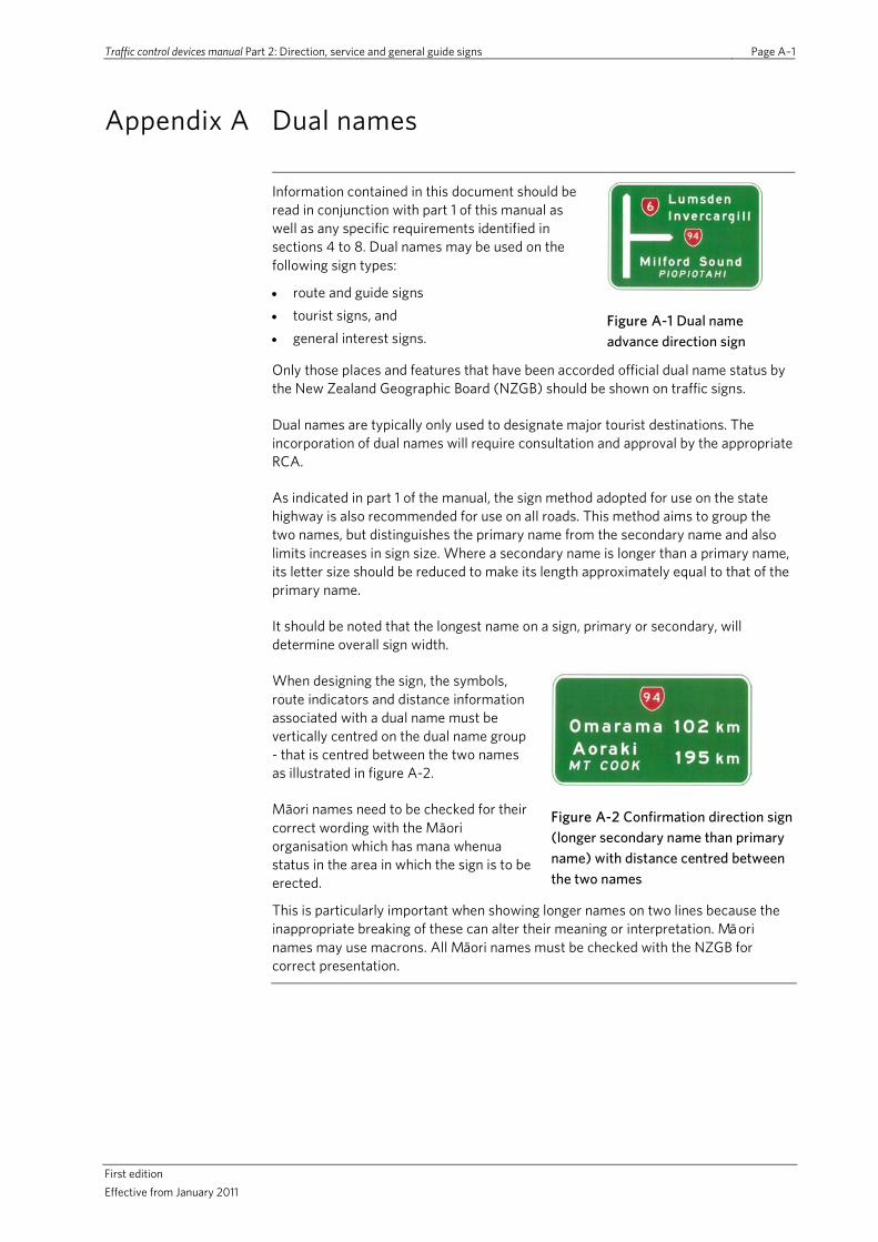
Traffic control devices manual Part 2: Direction, service and general guide signs Page A–1
First edition Effective from January 2011
Appendix A Dual names
Information contained in this document should be read in conjunction with part 1 of this manual as well as any specific requirements identified in sections 4 to 8. Dual names may be used on the following sign types:
• route and guide signs • tourist signs, and • general interest signs.
Figure A-1 Dual name advance direction sign
Only those places and features that have been accorded official dual name status by the New Zealand Geographic Board (NZGB) should be shown on traffic signs.
Dual names are typically only used to designate major tourist destinations. The incorporation of dual names will require consultation and approval by the appropriate RCA.
As indicated in part 1 of the manual, the sign method adopted for use on the state highway is also recommended for use on all roads. This method aims to group the two names, but distinguishes the primary name from the secondary name and also limits increases in sign size. Where a secondary name is longer than a primary name, its letter size should be reduced to make its length approximately equal to that of the primary name.
It should be noted that the longest name on a sign, primary or secondary, will determine overall sign width.
When designing the sign, the symbols, route indicators and distance information associated with a dual name must be vertically centred on the dual name group - that is centred between the two names as illustrated in figure A-2.
Māori names need to be checked for their correct wording with the Māori organisation which has mana whenua status in the area in which the sign is to be erected.
Figure A-2 Confirmation direction sign (longer secondary name than primary name) with distance centred between the two names
This is particularly important when showing longer names on two lines because the inappropriate breaking of these can alter their meaning or interpretation. Māori names may use macrons. All Māori names must be checked with the NZGB for correct presentation.

Traffic control devices manual Part 2: Direction, service and general guide signs Page A–2
First edition Effective from January 2011
Existing signs When dual names are added to existing guide signs, the number of destinations shown may have to be reduced to keep the amount of destination information shown within the normal maximum allowed. This is important as it:
• ensures drivers will be able to read, understand and react to the sign message • reduces unnecessary increases in the size of sign panels, and • generally gives a more visually pleasing and balanced sign layout.
Dual names are considered to be two separate names. Accordingly, when dual names are to be shown on existing signs every excess destination name should be removed.
Lettering All primary names on guide signs should be checked for correct letter size. A letter size less than the minimum specified previously should never be used, except for secondary names which should conform to the minimum sizes specified.

Traffic control devices manual Part 2: Direction, service and general guide signs Page B–1
First edition Effective from January 2011
Appendix B Typical guide sign layouts
Figure B-1 Typical guide signs at a channelised rural major road intersection
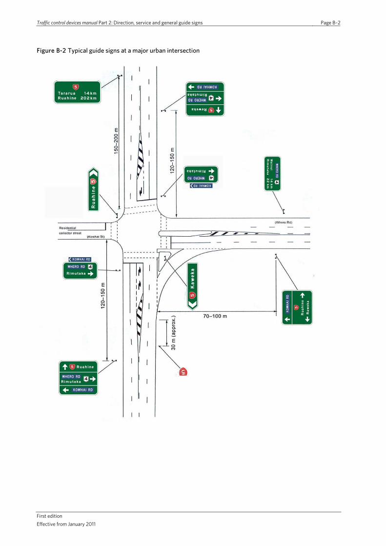
Traffic control devices manual Part 2: Direction, service and general guide signs Page B–2
First edition Effective from January 2011
Figure B-2 Typical guide signs at a major urban intersection

Traffic control devices manual Part 2: Direction, service and general guide signs Page B-3
First Edition Effective from January 2011
Figure B-3 Typical guide signs at a major roundabout

Traffic control devices manual Part 2: Direction, service and general guide signs Page B–4
First edition Effective from January 2011
This page is intentionally blank
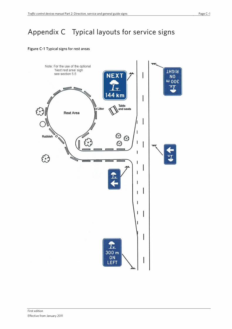
Traffic control devices manual Part 2: Direction, service and general guide signs Page C–1
First edition Effective from January 2011
Appendix C Typical layouts for service signs
Figure C-1 Typical signs for rest areas
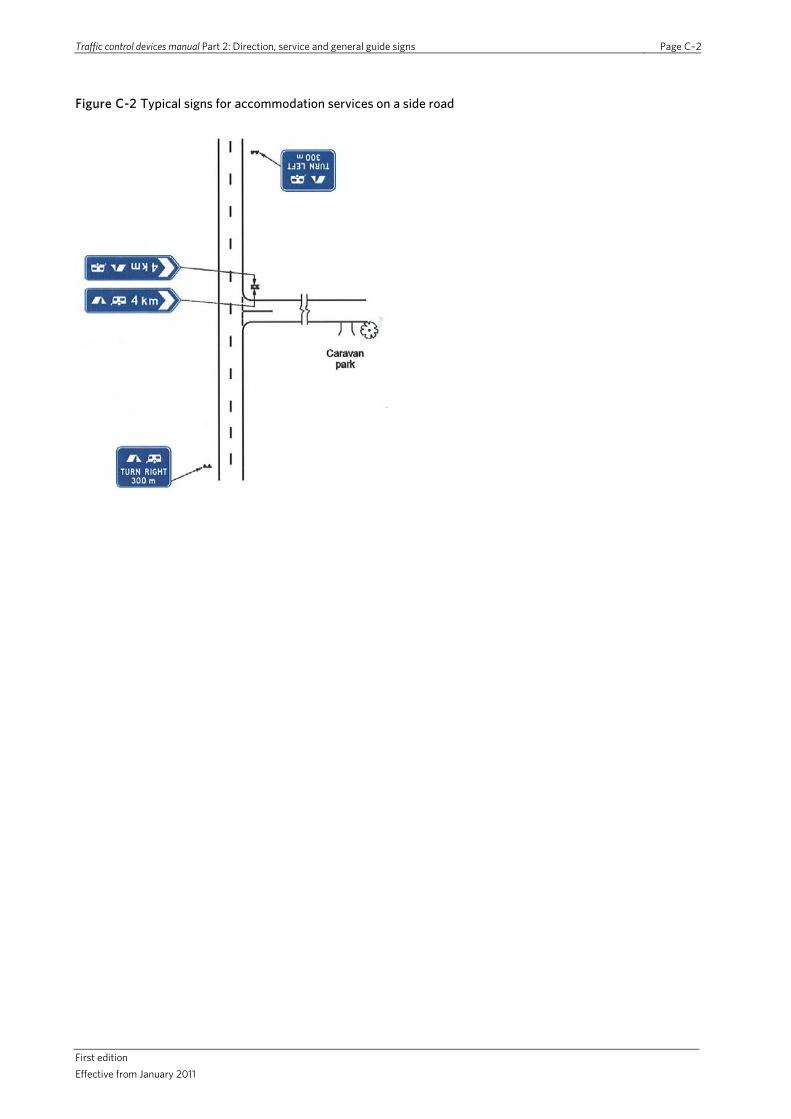
Traffic control devices manual Part 2: Direction, service and general guide signs Page C–2
First edition Effective from January 2011
Figure C-2 Typical signs for accommodation services on a side road
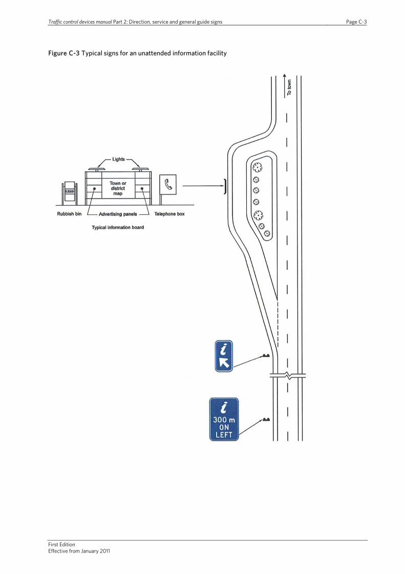
Traffic control devices manual Part 2: Direction, service and general guide signs Page C-3
First Edition Effective from January 2011
Figure C-3 Typical signs for an unattended information facility
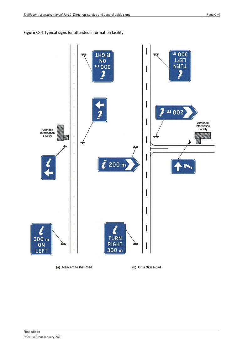
Traffic control devices manual Part 2: Direction, service and general guide signs Page C–4
First edition Effective from January 2011
Figure C-4 Typical signs for attended information facility

Traffic control devices manual Part 2: Direction, service and general guide signs Page D–1
First edition Effective from January 2011
Appendix D Example layouts for tourist signs
Figure D-1 Typical signs for a scenic lookout

Traffic control devices manual Part 2: Direction, service and general guide signs Page D–2
First edition Effective from January 2011
Figure D-2 Typical signs for a geographical feature (with parking on the opposite side of the road)
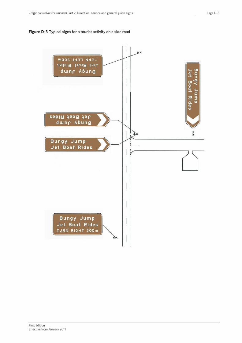
Traffic control devices manual Part 2: Direction, service and general guide signs Page D-3
First Edition Effective from January 2011
Figure D-3 Typical signs for a tourist activity on a side road

Traffic control devices manual Part 2: Direction, service and general guide signs Page D–4
First edition Effective from January 2011
Figure D-4 Typical signs for a tourist establishment adjacent to the road
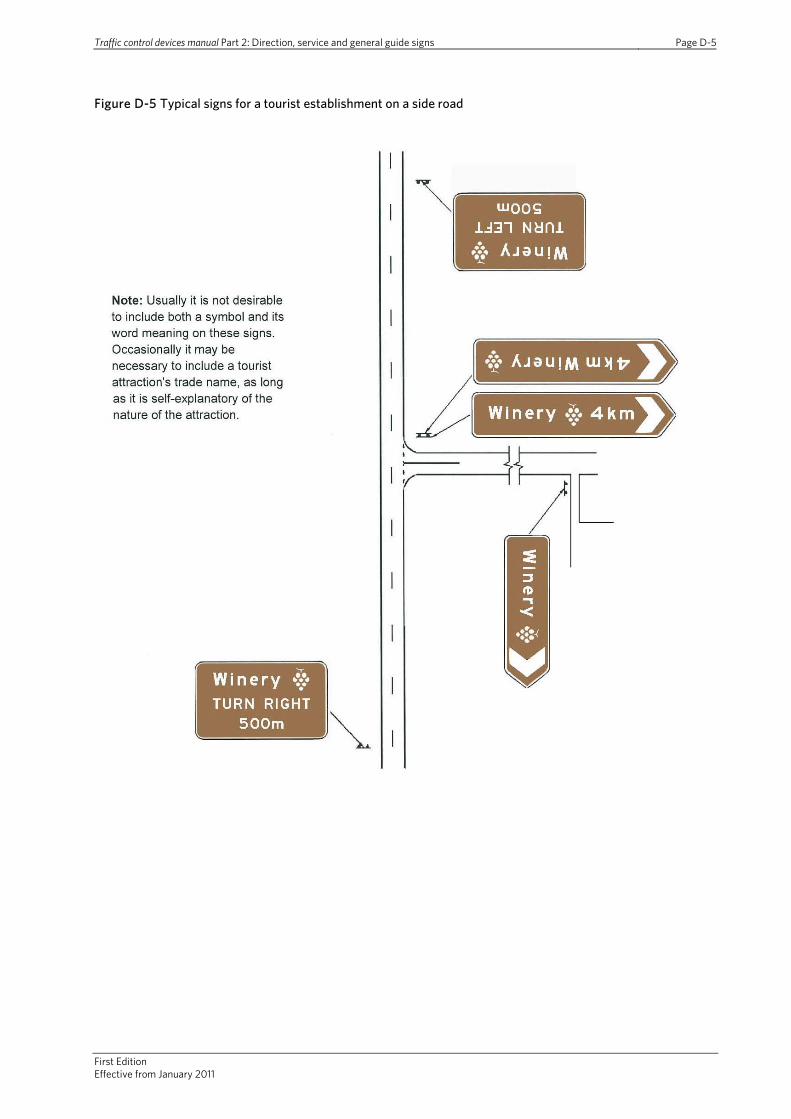
Traffic control devices manual Part 2: Direction, service and general guide signs Page D-5
First Edition Effective from January 2011
Figure D-5 Typical signs for a tourist establishment on a side road
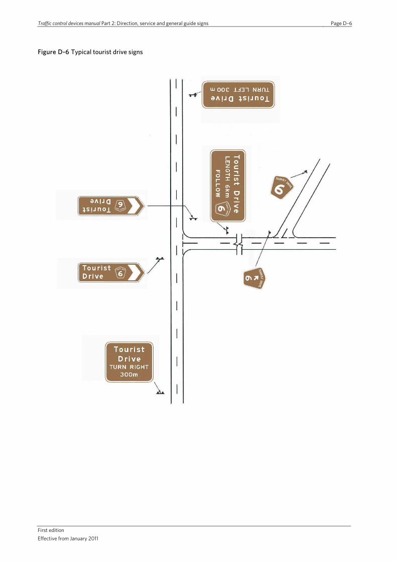
Traffic control devices manual Part 2: Direction, service and general guide signs Page D–6
First edition Effective from January 2011
Figure D-6 Typical tourist drive signs