traditional knowledge system based gis mapping of ... · and thus investigation of insecticidal...
TRANSCRIPT

Journal of Geographic Information System, 2014, 6, 478-491 Published Online October 2014 in SciRes. http://www.scirp.org/journal/jgis http://dx.doi.org/10.4236/jgis.2014.65041
How to cite this paper: Qayum, A., Lynn, A.M. and Arya, R. (2014) Traditional Knowledge System Based GIS Mapping of An-timalarial Plants: Spatial Distribution Analysis. Journal of Geographic Information System, 6, 478-491. http://dx.doi.org/10.4236/jgis.2014.65041
Traditional Knowledge System Based GIS Mapping of Antimalarial Plants: Spatial Distribution Analysis Abdul Qayum1,2*, Andrew Michael Lynn1*, Rakesh Arya3 1Center for Biology & Bioinformatics, School of Computational & Integrative Sciences, Jawaharlal Nehru University, New Delhi, India 2Indira Gandhi National Forest Academy, Dehradun, India 3Center for the Study of Regional Development, JNU, New Delhi, India Email: *[email protected], *[email protected] Received 25 July 2014; revised 20 August 2014; accepted 16 September 2014
Copyright © 2014 by authors and Scientific Research Publishing Inc. This work is licensed under the Creative Commons Attribution International License (CC BY). http://creativecommons.org/licenses/by/4.0/
Abstract The native communities have been using their unique traditional knowledge system (TKS), cul-ture, indigenous skills and expertise since the ancient times. India has witnessed its legacy from the time of Charaka & Susruta for TKS of medicinal plants. The objective of the study is to carry out inter-disciplinary work by integrating ethno-medicinal findings with Geographical Information System (GIS) tools to develop spatio-temporal maps covering antimalarial plants prevalent in three rural districts of Eastern Uttar Pradesh (UP), India. Two sources Flora Gorakhpurensis & Flora of Upper Gangetic Plains have been considered to evaluate all possible antimalarials preva-lent in the study region and are cross validated with research papers and journals. GPS coordi-nates were recorded for marked locations and under GIS environment maps of antimalarials are generated to highlight geographical distribution of such plants. Further, these are analysed with respect to various natural plant habitats. 48 plants belonging to 25 families were found and its geographical distribution is illustrated through series of GIS maps. The developed map highlights the geographical location of antimalarial plants and facilitates easy access of plant’s natural habi-tat. It is believed that the work would help researchers to find out the novel antimalarials towards open source drug discovery projects.
Keywords Antimalarial Plants, Bio-Prospecting, Geographical Distribution, GIS Mapping, Medicinal Plants, Vector Borne Disease
*Corresponding authors.

A. Qayum et al.
479
1. Introduction There is increased biotic pressure due to excessive increase in human population and over harvesting of nature and natural resource, resulting in increased attention to bio-prospecting [1]. The potential for physical flora col-lection to support scientific research is being enhanced by rapid development of information technology and remotely available digital database. India possesses rich floristic wealth and diversified genetic resources of me-dicinal plants. Several plants are used in traditional medicine for the treatment of vector borne diseases including malaria in many parts of the world [2]. Modern drugs have been deducted from folklore and traditional medi-cines [3] and hence the search for additional antimalarials from higher plants must continue to fight the deadly disease.
About 36% of world population is at risk of malaria. Around 2.5 million malaria cases are reported annually from South East Asia and 76% of it is in India (WHO, 2011). In the Tarai region of Eastern UP the spreading of vector borne diseases become uncontrolled especially during rainy seasons [4]. The need of the hour is to find new variety of drugs to combat the attack of mosquitoes who have found resistance to almost all old drugs. GIS provides the architecture and analysis tools to perform spatio-temporal modeling of disease transmission, and other factors relevant to the understanding of impacts and risk associated with malaria [5]. The effort has to be finding an alternative form of malaria control. Cost effective, practical and accessible interventions to be inte-grated into most malaria control programs. And thus investigation of insecticidal properties of plant-derived materials is environmentally safe, degradable and target specific.
Based on the parameters, like the recorded uses of medicinal plants, rarity and threat factors plant species and area can be identified to develop GIS based mapping using available software for visualizing, analyzing, creat- ing, and managing data with a geographic component. Most data has a component that can be tied to a place us- ing global positioning system (GPS) co-ordinates. GIS has been used as a “map maker” [6]. GIS supports multi- disciplinary analysis using a systematic approach and provides the ability to perform predictions of disease out- breaks based on available information. Later, plant density can also be calculated using image analysis algorithm applied on satellite data, and it can be cross validated with the available government data of forest of that area.
The trade in herbs and medicinal plants in UP at present stands at $1000 million per annum approximately. The growth rate has increased from 7% to 15% in the last couple of years, but export from the state is extremely inferior. In UP, over 250,000 hectare land comes under cultivation of herbs. The demand for herbal and natural products is escalating globally. The international market of herbal products is estimated above $62 billion while India’s share in the global market of export is merely 0.5% (Economic policy Business Standard 2009) [7]. The demand for the high time is to explore several means and launch various bio-prospecting projects to harvest natural wealth of the country sustainably. State government of UP has taken various initiatives towards meeting herbal and medicinal needs of people including cultivation of antimalarial medicinal plant Artemisia annua by Central Institute of Medicinal and Aromatic Plants (CIMAP) Lucknow. It is used to extract artemisinin, a com-pound which is most widely used compound in the development of antimalarial drug.
Ethnobotanical exploration with respect to food value has been done for north-eastern tarai region of UP and found 27 underutilized edible fruits consumed by ethnic people [8]. It widens the scope of bio-prospection and has established database of these fruits may be helpful in for achieving food security and environmental sus-tainability. For north east India all the antimalarial plants have been enlisted to emphasize the need for an alter-native drug for malaria for developing new indigenous antiplasmodic plants [9]. It has also been highlighted to-tal herbal plants used for the treatment of malaria and found that many of these plants are being used since an-cient times for the treatment of malaria throughout the world [10].
The current work is an amalgamation of data collection and its cross validation. It is based on two sources namely “Flora Gorakhpurensis” & “Flora of Upper Gangetic Plains” and cross validated with available literature survey (Figure 1). This is done to evaluate future prospects of all antimalarials prevalent in the region. Avail-able literature amounts to numerous research papers and journals related such work of compilation of antimalar-ial plants and GIS applications. From the study area 48 antimalarial plants were reported. GPS coordinates were recorded for marked locations and under GIS environment maps of antimalarials are generated to highlight geo-graphical distribution of such plants. Further, these are analysed with respect to various natural plant habitats. Having life in close vicinity of the nature, traditional societies have acquired unique knowledge about the use of flora and fauna in wild, most of which are still unknown to the common masses. The traditional knowledge, skills and practices thus developed are freely exchanged, cared for and nourished as a common property of the

A. Qayum et al.
480
Figure 1. Work strategy.
communities [11]. The current work has highlighted the geographical location (habitat) of antimalarial plants along with other details like plant species, plant family and local name.
The objective of the current study is to carry out inter-disciplinary work by integrating ethno-medicinal find-ings with GIS tools to develop spatio-temporal maps covering antimalarial plants prevalent in three rural dis-tricts of eastern UP, India. Further, the aim is to adapt and apply map design principles to minimize cognitive and perceptual burden of exploring complex data sets. Spatial distribution of malaria using GIS happens to be a de novo approach in defining plants of a given locality and the advancement in information technology will cer-tainly give an edge to this emerging field of research.
2. Materials and Methods 2.1. Study Area The study area outlines three rural (Rural Population: 88.53%) districts of north-eastern corner of the most populous state of UP, India (Figure 2) with 3.82% state area. It is surrounded by rivers Rapti (tributary to the Gandak) and Rohini. Geographical extension of three districts are; Gorakhpur (Lat. 26˚13'N to 27˚29'N and Long. 83˚05'E to 83˚56'E), Kushinagar (Lat. 26˚39'N to 27˚15'N and Long. 83˚38'E to 84˚15'E) and Maharajganj (Lat. 26˚59'N to 27˚19'N and Long. 83˚09'E to 83˚45'E). It also shares international border with Nepal. The study area is home to 10,690,142 people of Indian masses with 48.60% female population and 1,680,587 as total house hold of which 87.98% is rural house hold [12]. Study area belongs to low socio-economic zone [13] with 3,462,855 total work participation (Female: 28.3%) & 1,708,932 main work participation (Female: 19.1%) and 1,753,923 marginal worker (Female: 37.3%) while monthly income is 70.3 USD and population is merely agrarian (97.48%) with 87,400 main industry working.
2.2. Data Collection Two sources Flora Gorakhpurensis [14] & Flora of Upper Gangetic Plains [15] have been considered to evaluate all possible antimalarials prevalent in the study region and are cross validated with numerous research papers and journals. GPS coordinates were recorded for marked locations and under GIS environment maps of antima-larials are generated to highlight geographical distribution of such plants. Further, these are analysed with re-spect to various natural plant habitats. To evaluate plants distribution a pie chart (Figure 3) has been drawn for plants present in various habitats.
2.3. Methodology Study is based on extraction of ethno-medicinal utilities of plants based on two sources and cross examined with traditional knowledge (TK) available in relevant literatures [3] [9] [16]-[22] including various research papers & journals to obtain Table 1. For geographical location; GPS (Global Positioning System) coordinates were re- corded. The GIS Maps were generated through satellite imageries, plant location description and GPS observa-

A. Qayum et al.
481
Table 1. Antimalarial plants prevalent in the study area.
S. No. Plant species Family Local name Plant habitat
1 Abrus precatorius Linn. Fabaceae Ratti, Ghumchi Fruit orchard & climbing over trees.
2 Acacia farnesiana (L.) Willd. Fabaceae Tarua kadam (Ass) Found wild in wastelands, cultivated in gardens.
3 Achyranthes aspera Linn. Amaranthaceae Chirchita/Apamarga/Chitchita Roadsides, hills up to 900 m, Railway lines, wastelands.
4 Adhatoda vasica Nees Acanthaceae Arusa/Vasaka Cultivated lands, Waste places & Railway tracks.
5 Aerva lanata (L.) Juss. ex Schult. Amaranthaceae Gorakhganja/Bhadra Weed of crop fields, in fruit orchards.
6 Alstonia scholaris (L.) R.Br. Apocyanaceae Saptaparna/Saptachada/chatiyan Planted as roadside tree & also found wild.
7 Alternanthera sessilis (L.) R.Br. ex DC. Amaranthaceae Gudrisag/Matsyaksi Weed of cultivated field &
in moist waste places.
8 Amaranthus spinosus Linn. Amaranthaceae Chaulai Bhaji, Cholai Along roads, canals, railway tracks & weed of cultivated fields.
9 Ammannia baccifera Linn. Lythraceae Dadamari Marshy lands, Paddy fields, moist places
10 Andrographis paniculata Wall. ex Nees Acanthaceae Kalmegh Shady waste grounds.
11 Asteracantha longifolia (L.) Nees Acanthaceae Talmakhana Shallow ditches along roads.
12 Azardirachta indica A. Juss Meliaceae Neem Planted in gardens & near temples.
13 Barleria prionitis Linn. Acanthaceae Kastira, Bajradanti Waste ground, planted as border plant.
14 Bauhinia variegata Linn. Fabaceae Kachnar Planted in gardens & as roadside tree.
15 Boerhaavia diffusa L.nom.cons. Nyctaginaceae Gadapurna/Punarnava
Elevated lands, roadsides, railway tracks, waste places, crevices of walls & orchards.
16 Caesalpinia crista (Linn.) Fabaceae Kat-karanj, Karanju Open wastelands & along Nallas.
17 Carica papaya Linn. Caricaceae Papita Cultivated around bungalows & gardens.
19 Cissampelos pareira Linn. Menispermaceae Harjuri, Bharatbuti Fruit orchard, & as hedges of parks & gardens.
20 Citrus medica Linn. Rutaceae Jamerinimbu Planted in Gardens, Lahladpur area.
21 Clerodendron infortunatum Linn. Verbenaceae Bhat Under shades of trees, fruit orchards.
22 Cuscuta reflexa Roxb. Convolvulaceae Amarbel Twining upon Adhatoda vasica, near Surajkund, Tiwaripur region.
23 Cyperus scariosus Br. Cyperaceae Nagarmotha/Chakranksha Shallow water bodies of study area.
24 Datura metel Linn. Solanaceae Dhatura Frequently in waste places.
25 Eclipta prostrata (Linn.) Linn. Asteraceae Bhangraiya, Bhringaraj Open pastures, wet regions, along water canals.

A. Qayum et al.
482
Continued
26 Erythrina variegata Linn. Fabaceae Pangara Moderate sized deciduous tree planted in gardens, Near Ramgarh tal.
27 Jatropha gossypifolia Linn. Euphorbiaceae Bhakrend Roadside weed & found at other waste ground.
28 Lantana camara Linn. Verbenaceae Ghaneri Roadsides, Wild, Wastelands & Railway colony.
29 Leucas aspera (Willd.) Link. Lamiaceae Gopha, Drona pushpi Weed of crop field, waste places, dry open sandy soil, Bhathat region.
30 Ludwigia octovalvis (Jacq.) P.H. Raven Onagraceae Panijalokia Wet places, sides of tanks.
31 Magnolia grandiflora Linn. Magnoliaceae Andachampa Planted in gardens, Gorakhnath temple area.
32 Momordica charantia Linn. Cucurbitaceae Kathnim, Karavellaka Cultivated, found wild, climbing on hedges.
33 Murraya koenigii (L.) Sprengel Rutaceae Bursunga/Gandhla Deciduous shrub on waste grounds along water bodies, planted in gardens.
34 Nyctanthes arbortristis Linn. Oleaceae Harsingar Gardens, Bungalow, Temple & Railway colonies.
35 Ocimum sanctum Linn. Lamiaceae Tulsi Found as an escape from cultivation in moist places.
36 Oenanthe javanica (BL.) DC. Apiaceae Pan tarori Weed in moist waste places, fruit orchards, along water channels.
37 Pongamia pinnata (L.) Pierre Fabaceae Karanja Roadside, near Canals, Wasteland, Moist regions, Pharenda & Ramgarh forest.
38 Putranjiva roxburghii (Wall.) Euphorbiaceae Putjev, Jiaputa, Putrajiva Wild, tropical & cultivated, hedge plants in gardens.
39 Rauvolfia serpentine (Linn.) Benth. Apocynaceae Dhamarharua Damp places, wild in forests.
40 Scoparia dulcis Linn. Scrophulariaceae Mithi patti Waste places & a weed of crop fields.
41 Sida rhombifolia Linn. Malvaceae Bariara Shady waste places near tals (water bodies), hedges.
42 Solanum indicum Linn. Solanaceae Lapta Brihatti, Banbhanta Found as wild in whole study area.
43 Stephania japonica (Thunb.) Miers. Menispermaceae Rajpatha Hedges on moist ground.
44 Streblus asper Lour. Moraceae Singhor Small evergreen tree found throughout.
45 Tinospora cordifolia (Thunb.) Miers. Menispermaceae Gurch, Giloe On hedges & trees, tropical
regions of study area.
46 Vandellia sessiliflora Benth. Scrophulariaceae Lindernia sp. Indian Damp & shady places, grows with grasses.
47 Vernonia cinerea (Linn.) Less. Asteraceae Sahdevi Weed of crop field & waste grounds.
48 Xanthium strumarium Linn. Asteraceae Lapetua Waste places, long railway tracks & roadsides.

A. Qayum et al.
483
Figure 2. Location of study area.
Figure 3. Plant distribution in various habitats.
tions using ArcGIS 10.
2.4. GIS Mapping The distribution of antimalarial plants is mapped based on references drawn from available literature, opera-tional land imager (OLI) satellite imagery and limited field verification using GPS. The data collected from mentioned sources is integrated in ArcGIS 10 environment. Further, it is extrapolated over similar geographical environment using satellite imageries.
A. Qayum et al.
484
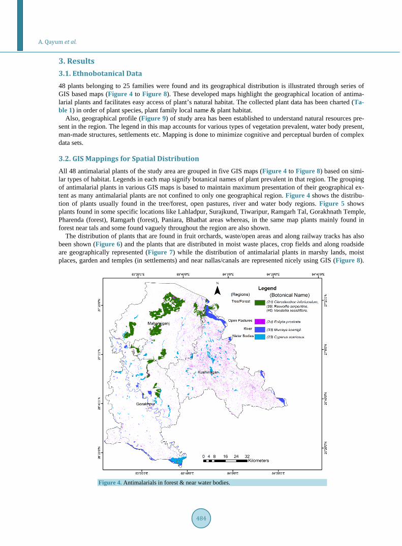
3. Results 3.1. Ethnobotanical Data 48 plants belonging to 25 families were found and its geographical distribution is illustrated through series of GIS based maps (Figure 4 to Figure 8). These developed maps highlight the geographical location of antima-larial plants and facilitates easy access of plant’s natural habitat. The collected plant data has been charted (Ta- ble 1) in order of plant species, plant family local name & plant habitat.
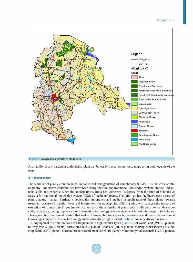
Also, geographical profile (Figure 9) of study area has been established to understand natural resources pre-sent in the region. The legend in this map accounts for various types of vegetation prevalent, water body present, man-made structures, settlements etc. Mapping is done to minimize cognitive and perceptual burden of complex data sets.
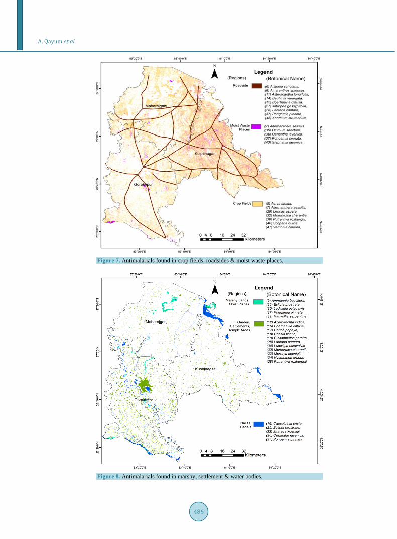
3.2. GIS Mappings for Spatial Distribution All 48 antimalarial plants of the study area are grouped in five GIS maps (Figure 4 to Figure 8) based on simi-lar types of habitat. Legends in each map signify botanical names of plant prevalent in that region. The grouping of antimalarial plants in various GIS maps is based to maintain maximum presentation of their geographical ex-tent as many antimalarial plants are not confined to only one geographical region. Figure 4 shows the distribu-tion of plants usually found in the tree/forest, open pastures, river and water body regions. Figure 5 shows plants found in some specific locations like Lahladpur, Surajkund, Tiwaripur, Ramgarh Tal, Gorakhnath Temple, Pharenda (forest), Ramgarh (forest), Paniara, Bhathat areas whereas, in the same map plants mainly found in forest near tals and some found vaguely throughout the region are also shown.
The distribution of plants that are found in fruit orchards, waste/open areas and along railway tracks has also been shown (Figure 6) and the plants that are distributed in moist waste places, crop fields and along roadside are geographically represented (Figure 7) while the distribution of antimalarial plants in marshy lands, moist places, garden and temples (in settlements) and near nallas/canals are represented nicely using GIS (Figure 8).
Figure 4. Antimalarials in forest & near water bodies.

A. Qayum et al.
485
Figure 5. Antimalarials found throughout area & some specific locations.
Figure 6. Antimalarials of orchards, waste lands & railway tracks.
A. Qayum et al.
486
Figure 7. Antimalarials found in crop fields, roadsides & moist waste places.
Figure 8. Antimalarials found in marshy, settlement & water bodies.
A. Qayum et al.
487
Figure 9. Geographical profile of study area.
Availability of any particular antimalarial plant can be easily traced across these maps using both legends of the map.
4. Discussion The work is not purely ethnobotanical in nature but amalgamation of ethnobotany & GIS. It is the work of eth-nography. The native communities have been using their unique traditional knowledge system, culture, indige-nous skills and expertise since the ancient times. India has witnessed its legacy from the time of Charaka & Susruta for traditional knowledge system (TKS) of medicinal plants. The GIS map has facilitated easy access of plant’s natural habitat. Further, it depicts the importance and method of application of these plants towards treatment in case of malaria, fever and intermittent fever. Applying GIS mapping will catalyse the process of extraction of artemisinin & quinine derivatives from the antimalarial plants and it will be a novice idea espe-cially with the growing importance of information technology and advancement in satellite imagery techniques. This region has monsoonal rainfall that makes it favourable for vector borne diseases and hence the traditional knowledge coupled with new technology makes this study highly useful for basic amenity stressed regions.
Geographical distribution has been fragmented to eight habitat types (Table 2) of waste land (WL-15 plants), railway tracks (RL-6 plants), forest area (FA-5 plants), Roadside (RD-9 plants), Marshy/Moist Places (MM-9), crop fields (CF-7 plants), Garden/Orchard/Settlement (GOS-16 plants), water body/nallas/canals (WB-9 plants),

A. Qayum et al.
488
Table 2. Distribution of plant in various natural habitats.
Plant species Natural habitats of plants
WL RL FA RD MM CF GOS WB WR
Abrus precatorius Linn. √
Acacia farnesiana (L.) Willd. √
Achyranthes aspera Linn. √ √
Adhatoda vasica Nees √ √
Aerva lanata (L.) Juss. ex Schult. √
Alstonia scholaris (L.) R.Br. √ √ √
Alternanthera sessilis (L.) R.Br.ex DC. √ √ √
Amaranthus spinosus Linn. √
Ammannia baccifera Linn. √
Andrographis paniculata Wall. Nees √
Asteracantha longifolia (L.) Nees √
Azardirachta indica A.Juss √
Barleria prionitis Linn. √
Bauhinia variegata Linn. √
Boerhaavia diffusa L.nom.cons. √ √ √ √
Caesalpinia crista (Linn.) √ √
Carica papaya Linn. √
Cassia fistula Linn. √
Cissampelos pareira Linn. √
Citrus medica Linn. √
Clerodendron infortunatum Linn. √ √
Cuscuta reflexa Roxb. √ √
Cyperus scariosus Br. √
Datura metel Linn. √
Eclipta prostrata (Linn.) Linn. √ √
Erythrina variegata Linn. √ √
Jatropha gossypifolia Linn. √ √
Lantana camara Linn √ √ √
Leucas aspera (Willd.) Link. √ √
Ludwigia octovalvis (Jacq.) P.H.Raven √ √
Magnolia grandiflora Linn. √
Momordica charantia Linn. √ √
Murraya koenigii (L.) Sprengel √ √
Nyctanthes arbor-tristis Linn. √

A. Qayum et al.
489
Continued
Ocimum sanctum Linn. √
Oenanthe javanica (BL.) DC. √ √
Pongamia pinnata (L.) Pierre √ √ √ √
Putranjiva roxburghii (Wall.) √ √
Rauvolfia serpentine (Linn.) Benth. √ √
Scoparia dulcis Linn. √ √
Sida rhombifolia Linn. √ √
Solanum indicum Linn. √
Stephania japonica (Thunb.) Miers. √
Streblus asper Lour. √
Tinospora cordifolia (Thunb.) Miers. √
Vandellia sessiliflora Benth. √
Vernonia cinerea (Linn.) Less. √ √
Xanthium strumarium Linn. √ √
WL = Waste Land, RL = Railway Tracks, FA = Forest Area, RD = Roadside, MM = Marshy/Moist Places, CF = Crop Fields, GOS = Garden/Or- chard/Settlement, WB = Water Body/Nallas/Canals, WR = Whole Region. whole region (WR-3 plants). There are many plants found in more than one habitat type. Largest number of plants is found in gardens, orchard and settlements while as many as 15 plants are found in waste lands. There are three plants Solanum indicum, Streblus asper and Tinospora cordifolia which are found throughout the study area & in abundance (Figure 5). In the study area two species namely Nagarmotha (Cyperus scariosus) and Goma or Drona pushpi (Leucas aspera) are at the verge of extinction mainly due to the change in water reser-voir structure i.e. because of loss of water bodies like ponds and other reservoirs for the former and because of change in land-use pattern for the latter. Further, due to ruthless exploitation, many important medicinal plants species are becoming rare and some of them are critically endangered (As per the IUCN, Switzerland Red List Criteria). It is estimated that 10% of all plant species are currently endangered in India [19].
Herbal medicines have good values in malaria treatment and because of its potential in many countries scien-tific investigations are undergoing and nearly 85% traditional medicines are plant derived [23]. Conservation of natural resources as well as its sustainable use is important in preservation of traditional knowledge.
Series of works have been done on ethno-botany work and ethno-ecology. However, GIS based mapping is indeed a novice idea. Spatial distribution using GIS happens to be new field of research and can be used in de-fining plants of a given region. Geo-visualization research in last 15 years directed considerable effort towards enhancing dynamic and interactive maps [24]. There are many remote places which are restricted for any physi-cal reach for identification of plants. In this peculiar circumstance GIS could be a tool to address all these com-plexities using extrapolation techniques. Study area in the work happens to be least developed part of one of the poorest State in India. Thus, working for low socio-economic profile region will certainly be useful at larger scale and will bear extended benefits when the work will be thoroughly evaluated. The geographical maps (Fig- ures 4-7, Figure 9) are primarily drawn on the basis of GPS co-ordinates collected during field visit. But there are many remote points which remained unreachable because of rainy seasons and geographical terrain and hence for such regions extrapolation was done. Using the map results one can directly approach for any particu-lar plant and assesses its geographical health. It gives precise location of plants in the identified geographical territory.
5. Conclusions The work would help researchers to find out the novel antimalarials towards open source drug discovery pro-jects. GIS maps serve the purpose of emphasizing spatial distribution of plants. GIS mapping has got potential

A. Qayum et al.
490
application in field of traditional knowledge mapping in times to come. Much work in this promising field has yet to be done. Integrating legends (of plant botanical names) with maps enhance readability of maps and it can be easily understood for the geographical features of the study region. The GIS based technique can be used to trace a given antimalarial geographically in a speedy manner. There exists alarming need to conserve and protect these important species for sustainable harvesting. A serious endeavor has to be taken to save these natural re-sources for the generations to come.
The work carried out in the region reveals that the plants recorded are highly valuable for antimalarial appli-cation and in future; bio-prospecting projects can be further initiated for sustainable harvesting towards devel-oping antimalarial drug for curing malaria at large. A GIS based national mapping of antimalarials can be aimed and the task can be integrated with on-going umbrella projects bio-prospection of CSIR, New Delhi under do-main of open source drug discovery for malaria (OSDDm). Some plants are nearly extinct in the region, the reason being change in land use pattern and shrinking of water bodies along with overharvesting of herbs. The bio-depletion of these antimalarials is due to the burgeoning population.
The GIS based approach can be made microscopic further by accommodating geographical features linked to growth of an antimalarial plant in a given area. Developing a link between information technology and ethno- botany will be a novice idea especially when world technology is changing rapidly. GIS has touched all walks of human interfaces and thus application of GIS in the research paper has been done to map antimalarial plants of any given locality. Traditional plant knowledge and plant spatial distribution can be linked further and its under-standing is enhanced with GIS mappings. It is anticipated that in times to come GIS will be a dominant tool to understand ethnography.
Acknowledgements We are highly indebted to the Open Source Drug Discovery Project for malaria of CSIR, New Delhi for provid-ing financial assistance which kept constant high motivation throughout the work. We also acknowledge the computer laboratory facility at School of Computational & Integrative Sciences and Centre for the Study of Re-gional Development, Jawaharlal Nehru University, New Delhi and is equally indebted to the Ministry of Envi-ronment & Forest, MoEF Govt. of India for its continuous support towards making this work plausible.
Conflict of Interest None declared.
Prior Informed Consent and Ethic Not required.
References [1] Kipgen, S. (2013) Bioprospecting and Identification of Anti-Malarial Compounds in Plants from Biodiversity-Rich
Areas in India. CSIR-OSDD Natural Plant Products Project. [2] Saxena, S., Pant, N., Jain, D.C. and Bhakuni, R.S. (2003) Antimalarial Agents from Plant Sources. Current Science, 85,
1314-1329. [3] Verma, A.K., Kumar, M. and Bussmann, R.W. (2007) Medicinal Plants in an Urban Environment: The Medicinal
Flora of Banares Hindu University, Varanasi, Uttar Pradesh. Journal of Ethnobiology and Ethnomedicine, 3, 35. [4] Qayum, A., Lynn, A.M., Arya, R. and Jaiswal, S.K. (2013) GIS Integrated Epidemiological Indices for Risk Area
Identification towards Malaria Control Measures. International Journal of Engineering and Advanced Technology (IJEAT), 2, 376-381.
[5] Auer, T., MacEachren, A.M., McCabe, C., Pezanowski, S. and Stryker, M. (2012) HerbariaViZ: A Web-Based Cli-ent-Server Interface for Mapping & Exploring Flora Observation Data. Ecological Informatics Elsevier, 6, 93-110. http://dx.doi.org/10.1016/j.ecoinf.2010.09.001
[6] Murty, U.S.N. (2012) Epidemiological Modelling of Malaria in Endemic Zones of India. OSDD Malaria Project. [7] Economic Policy Business Standard (2009) Uttar Pradesh Seeks MSP for Medicinal Plants.
http://www.business-standard.com [8] Srivastava, R. (2013) Underutilised Fruits: A Potential of Local food Resource. International Journal of Pharma & Bio

A. Qayum et al.
491
Sciences, 4, 1301-1305. [9] Shankar, R., Deb, S. and Sharma, B.K. (2011) Antimalarial Plants of Northeast India: An Overview. Journal of Ay-
urveda & Integrative Medicine (JAIM), 3, 10-16. http://dx.doi.org/10.4103/0975-9476.93940 [10] Bahekar, S. and Kale, R. (2013) Herbal Plants Used for the Treatment of Malaria—A Literature Review. Journal of
Pharmacognosy and Phytochemistry, 1, 141-146. [11] Pushpangadan, P. and Kumar, B. (2005) Ethnobotany, CBD, WTO and the Biodiversity Act of India. Ethnobotany, 17,
2-12. [12] Census of India (2011) Directorate of Census Operations Uttar Pradesh Administrative Atlas 2012.
http://www.census2011.co.in/census/state/uttar+pradesh.html [13] Economics and Statistics Division (2011) Govt. of Uttar Pradesh, India. http://updes.up.nic.in [14] Srivastava, T.N. (1976) Flora Gorakhpurensis. Today & Tomorrow’s Print. & Publ., New Delhi. [15] Duthie, J.F. (1960) Flora of Upper Gangetic Plains. Botanical Survey of India Publisher, Vol. I & II. [16] Kamaraj, C., et al. (2012) Antimalarial Activities of Medicinal Plants Traditionally Used in the Villages of Dharmapuri
Regions of South India. Journal of Ethnopharmacology, 141, 796-802. [17] Kumar V. and, Akhtar M. (2013) Ethanomedicinal Solanaceous Plants of Eastern Uttar Pradesh. Indian Journal of Life
Sciences, 2, 95-98. [18] Mishra, S.B., Dwivedi, S., Shashi, A. and Prajapati, K. (2008) Ethnomedicinal Uses of Some Plant Species by Ethnic
and Rural Peoples of the Salem District of Tamilnadu with Special Reference to the Conservation of Vanishing Species. Ethnobotanical Leaflets, 12, 873-887.
[19] Pandey, A.K., Patra, A.K. and Shukla, P.K. (2005) Medicinal Plants in Satpura Plateau of Madhya Pradesh: Current Status and Future Prospects. Indian Forester, 131, 857-883.
[20] Pandey, A.K. and Tripathi, N.N. (2010) Diversity and Distribution of Aromatic Plants in Forests of Gorakhpur Divi-sion, U.P., India. Biological Forum: An International Journal, 2, 25-33.
[21] Pandey, A.K. and Tripathi, N.N. (2011) Aromatic Plants of Gorakhpur Division: Their Anti-Mycotic Properties & Me-dicinal Value. International Journal of Pharmaceutical Science Review & Research, 7, 142-147.
[22] Prakash, A. (2011) Uses of Some Threatened and Potential Ethnomedicinal Plants among the Tribals of Uttar Pradesh and Uttrakhand in India. National Conference on Forest Biodiversity: Earth’s Living Treasure, 22 May 2011, 93-99.
[23] Jain, D.L., Baheti, A.M., Jain, S.R. and Khandelwal, K.R. (2010) Use of Medicinal Plants among Tribes in Satpuda Region of Dhule and Jalgaon Districts of Maharashtra—An Ethnobotanical Survey. Indian Journal of Traditional Knowledge, 9, 152-157.
[24] MacEachren, A.M., Crawford, S., Akella, M. and Lengerich, G. (2008) Design and Implementation of a Model, Web- Based, GIS-Enabled Cancer Atlas. The Cartographic Journal, 45, 246-260. http://dx.doi.org/10.1179/174327708X347755
