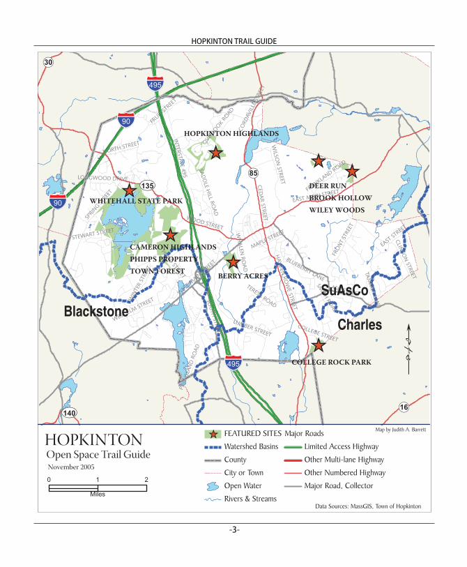
town of hopkintondata sources: massgis, town of hopkinton november 2005 map by judith a. barrett....
TRANSCRIPT
TOWN OF HOPKINTON
Hopkinton Trail Guide
COPEN SPACE
First Edition 2006Supported by a grant from the William P. Wharton Trust
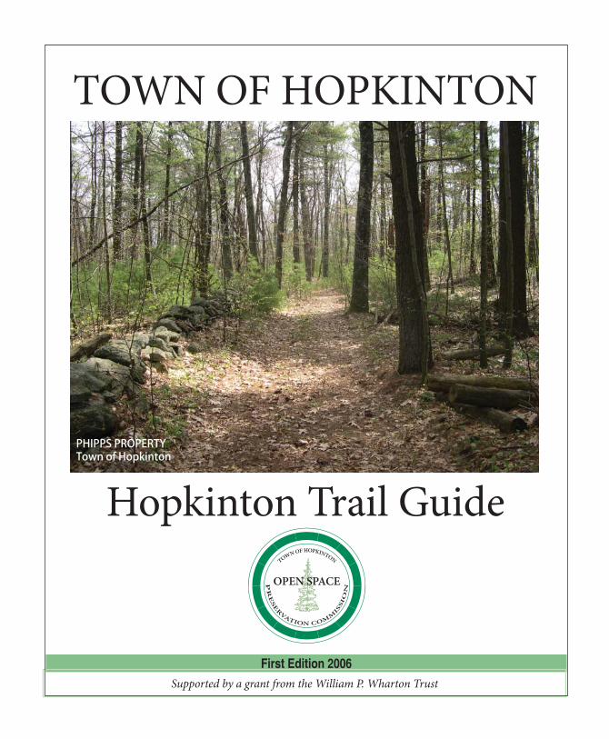
PHIPPS PROPERTYTown of Hopkinton
Hopkinton Open Space Preservation Commission
Open Space Trail Guide
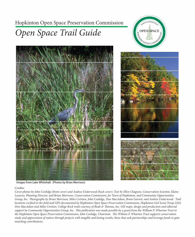
Credits: Cover photos by John Coolidge (front cover) and Andrea Underwood (back cover). Text by Ellen Chagnon, Conservation Scientist, Elaine Lazarus, Planning Director, and Brian Morrison, Conservation Commission, for Town of Hopkinton, and Community Opportunities Group, Inc. Photographs by Brian Morrison, Miles Crettien, John Coolidge, Don MacAdam, Brian Garrett, and Andrea Underwood. Trail locations verifi ed in the fi eld and GPS-documented by Hopkinton Open Space Preservation Commission, Hopkinton Girl Scout Troop 2245, Don MacAdam and Miles Crettien. College Rock trails courtesy of Beals & Th omas, Inc. GIS maps, design and production and editorial support by Community Opportunities Group, Inc. Th is publication was made possible by a grant from the William P. Wharton Trust to the Hopkinton Open Space Preservation Commission, John Coolidge, Chairman. Th e William P. Wharton Trust supports conservation study and appreciation of nature through projects with tangible and lasting results, those that seek partnerships and leverage funds to gain matching contributions.
Images from Lake Whitehall. (Photos by Brian Morrison)
COPEN SPACE
HOPKINTON TRAIL GUIDE
-1-
ABOUT THIS GUIDEHopkinton is a recognized leader in open space protection. Th rough careful planning, land acquisitions, zoning, and working closely with state agencies and non-profi t land trusts, Hopkinton has assembled an impressive inventory of open space: 4,700 acres, including 2,800 acres that are protected in perpetuity. Th e Hopkinton Trail Guide attests to the eff orts of several generations of residents to protect the Town’s natural resources and scenic views, to create open space links and corridors, and preserve the rural qualities that distinguish Hopkinton from most Boston-area suburbs.
All of the open space included in the Hopkinton Trail Guide is protected in perpetuity. Th e featured sites illustrate Hopkinton’s long-standing conservation ethic and its tradition of working in partnership with other organizations. For example, the Whitehall State Park was protected more than 100 years ago, while the Town purchased the Phipps Property in 2003. Th e sites in this guide off er unique recreation opportunities and exemplify the variety of landscapes that contribute to Hopkinton’s scenic beauty.
Saving Open SpaceHopkinton has found that protecting open space requires several conservation strategies and funding sources. Local residents and businesses donated some of the fi rst parcels to the Conservation Commission and other sites were acquired through tax title. However, the Town has also purchased a considerable amount of land for conservation and recreation purposes and made excellent use of zoning to save open space by design. In 1988,
Hopkinton adopted an Open Space and Landscape Preservation Development (OSLPD) Bylaw that has been unusually successful. More than 70% of all new subdivisions during the 1990s were developed as OSLPD projects and together, they preserved more than 740 acres of open space.
In addition, conservation-minded residents established a local land trust in 1995. Th e private, non-profi t Hopkinton Area Land Trust (HALT) purchases and manages land, and complements the Town’s open space eff orts through fundraising, providing outreach and education, constructing
trails, and negotiating with landowners. Later, Hopkinton created its own Open Space Preservation Commission and an Open Space Preservation Fund under Chapter 19 of the Acts of 1999. Since then, the Commission has focused exclusively on protecting open space and managing the Town’s open space land holdings. Th e Commission helps
landowners by negotiating conservation restrictions and promotes conservation and recreation land purchases. More recently, Hopkinton voters adopted the Community Preservation Act (CPA) in 2001. Under CPA, Hopkinton receives a 2% surcharge on all real estate assessments. Th ese funds may be used to buy open space, create aff ordable housing, and preserve or rehabilitate historic buildings.
Contact InformationTh e Hopkinton Trail Guide is a work in progress. As funds permit, the Open Space Preservation Commission will add new trails maps when the
Featured SitesBerry Acres
College Rock Park
Whitehall State Park
Cameron Highlands
Phipps Property
Hopkintoin Area Land Trust (HALT) Properties
HOPKINTON TRAIL GUIDE
-2-
Town acquires more land and blazes trails. Please contact the Conservation Commission (508-497-9757) or the Planning Department (508-497-9755) to make suggestions, volunteer, or inquire about preserving your property.
HOPKINTON’S NATURAL HISTORYGeology and TopographyTh e Wisconsinan glacier covered New England during the Pleistocene Epoch over 120,000 years ago and shaped Hopkinton’s hills and valleys. Th e glacier’s retreat 12,000 years ago left much of Hopkinton bedrock overlain by glacial till, or poorly-sorted material that includes sands, gravels, and rocks. Th e thin, rocky layer of topsoil results in poor farming conditions. Hopkinton’s bedrock consists almost entirely of granite, and ledge outcroppings can be seen in many parts of town.
Hopkinton lies within three watershed basins: Blackstone, Sudbury and Charles Rivers While most of the Town is within the Sudbury (Concord) watershed, the headwaters of the Charles River begin at Echo Lake in Hopkinton and Whitehall Brook feeds the Sudbury River. In general, Hopkinton’s terrain slopes rather sharply toward four man-made water bodies: Whitehall Reservoir (575 acres) to the west, Hopkinton Reservoir (83 acres in Hopkinton) to the north, and Lake Maspenock (253 acres) and Echo Lake (105 acres in Hopkinton) to the south. Wetlands dot the topography and small streams run throughout Hopkinton.
VegetationTh e southern New England hardwood (or mixed deciduous) forest in Hopkinton consists primarily of red and white oak and white pine. Th e understory of this dense forest includes shrubs such as huckleberry, mountain laurel, sweet pepperbush,
viburnums, and witch hazel and herbs and vines such as wintergreen, Canada mayfl ower, partridge berry, wild sarsaparilla, ferns (many species), ground pine, cat briar, and wild grape.
Th e appearance of the forest and the makeup of its vegetation change with elevation, soils, and moisture. Th e lakes, ponds and streams are generally surrounded by red maple swamp, including species such as highbush blueberry, swamp azalea, viburnum, winterberry, skunk cabbage, touch-me-not, sphagnum moss and red maple. Beware of poison ivy in the transition areas between wetland and upland.
WildlifeTh e mammal species typically present in Hopkinton’s woodlands and wetlands include white tail deer, coyote, red and gray fox, raccoon, skunk, possum, gray squirrel, woodchuck, chipmunk, eastern cottontail, porcupine, muskrat, beaver, mice, and voles. People occasionally see fi sher, bobcat and river otter as well, but all three are elusive. Songbirds, water birds, and birds of prey abound in the wild areas of town, and wild turkey populations are on the rise. Several residents have reported bald eagle sightings in the vicinity of Lake Whitehall.
In the winter and spring, vernal pools can be seen in the wetlands throughout Hopkinton. Th ese ephemeral ponds dry up in the summer and fall. Vernal pools serve as nurseries for wood frogs, and spotted and marbled salamanders, and as permanent homes for fairy shrimp, fi ngernail clams, and many other invertebrates. Th e “quacking” call of wood frogs and the high-pitched peep of the tiny spring peeper signify proximity to vernal pools. Please treat these fragile treasures with care.
Common species of reptiles and amphibians in Hopkinton include garter snake, water snake, snapping and painted turtles, bullfrog, green frog,
HOPKINTON TRAIL GUIDE
-3-
UV135
UV140
!(85
!(16
!(30
§̈¦495
§̈¦90
§̈¦495
§̈¦90
INTERSTATE
495
WOOD STREET
ASH STREETWES
T MAIN
STREE
T
POND
STREET
CED
AR
STREET
FRUIT
STREE
T
SPRI
NGST
REET
LUMBER STREET
WIN
TER
STRE
ET
CLINTO
NSTREET
SAD
DLE
HILL
ROA
D
HAYD
ENRO
WE STREET
SOU
THSTREET
EAST MAIN STREET
WEST ELM STREET
FRO
NT
STRE
ET
WILSO
NSTREET
FRANKLA
ND ROAD
TERESA ROAD
NORTH STREET OVER
LOO
KRO
AD
TAM
MER
LAN
E
EAST
STREE
T
BLUEBERRY LANE
LONGWOOD DRIVE
SMITH
ROAD
CORD
AVIL
LEST
REET
COLLEGE STREET
MAPLE STREETWH
ALEN
ROA
D
PIN
EIS
LAN
DRO
AD
STEWART STREET
SuAsCoBlackstone
Charles
[_
HOPKINTON
[_
[_
[_
[_ [_[_
BERRY ACRES
COLLEGE ROCK PARK
DEER RUNBROOK HOLLOWWILEY WOODS
WHITEHALL STATE PARK
CAMERON HIGHLANDSPHIPPS PROPERTYTOWN FOREST
HOPKINTON HIGHLANDS
FEATURED SITES
Watershed Basins
County
City or Town
Open Water
Rivers & Streams
Major Roads
Limited Access Highway
Other Multi-lane Highway
Other Numbered Highway
Major Road, Collector
[_
Open Space Trail Guide
!
0 21
Miles
Data Sources: MassGIS, Town of Hopkinton
November 2005
Map by Judith A. Barrett
HOPKINTON TRAIL GUIDE
-4-
spring peeper, American and Fowlers toads, and striped and red salamanders. Uncommon, rare or threatened wildlife species include damselfl y and dragonfl y species, wood duck, pheasant (stocked), osprey, turkey vulture, fl ying squirrel, spotted and mole salamanders, wood turtle, box turtle, spotted turtle, weasel and purple tiger beetle.
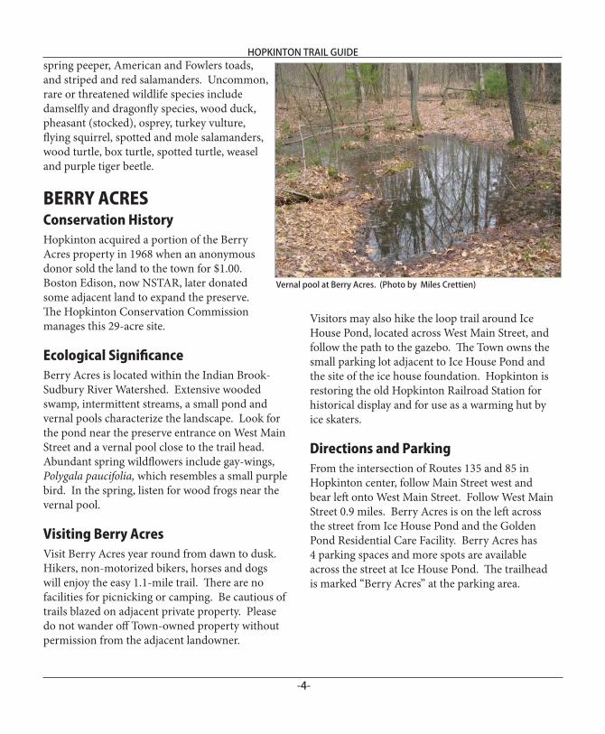
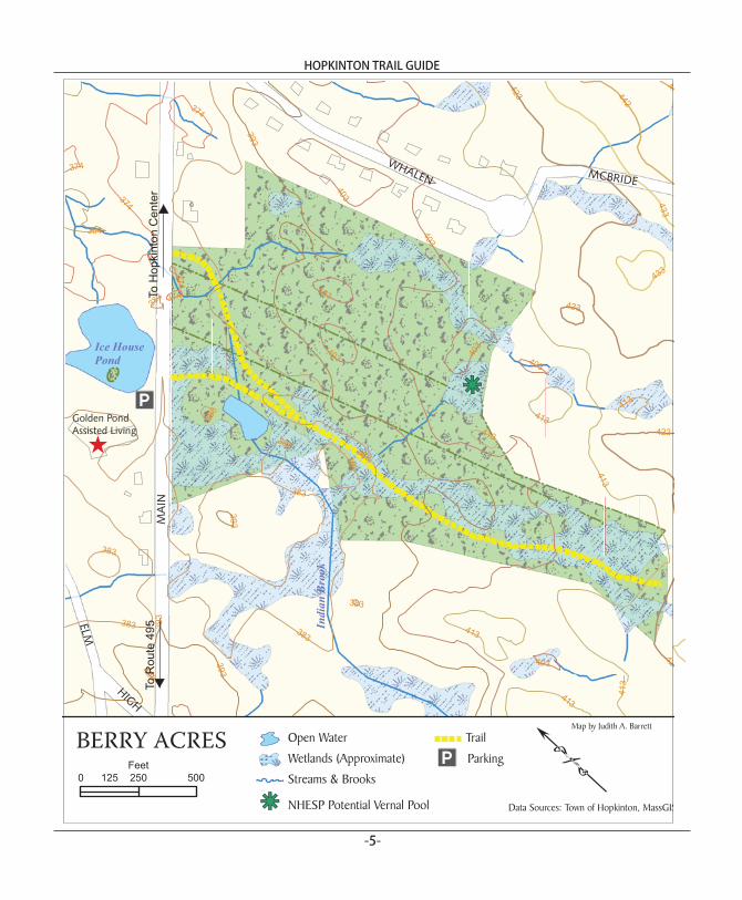
BERRY ACRESConservation HistoryHopkinton acquired a portion of the Berry Acres property in 1968 when an anonymous donor sold the land to the town for $1.00. Boston Edison, now NSTAR, later donated some adjacent land to expand the preserve. Th e Hopkinton Conservation Commission manages this 29-acre site.
Ecological Signifi canceBerry Acres is located within the Indian Brook-Sudbury River Watershed. Extensive wooded swamp, intermittent streams, a small pond and vernal pools characterize the landscape. Look for the pond near the preserve entrance on West Main Street and a vernal pool close to the trail head. Abundant spring wildfl owers include gay-wings, Polygala paucifolia, which resembles a small purple bird. In the spring, listen for wood frogs near the vernal pool.
Visiting Berry AcresVisit Berry Acres year round from dawn to dusk. Hikers, non-motorized bikers, horses and dogs will enjoy the easy 1.1-mile trail. Th ere are no facilities for picnicking or camping. Be cautious of trails blazed on adjacent private property. Please do not wander off Town-owned property without permission from the adjacent landowner.
Visitors may also hike the loop trail around Ice House Pond, located across West Main Street, and follow the path to the gazebo. Th e Town owns the small parking lot adjacent to Ice House Pond and the site of the ice house foundation. Hopkinton is restoring the old Hopkinton Railroad Station for historical display and for use as a warming hut by ice skaters. Directions and ParkingFrom the intersection of Routes 135 and 85 in Hopkinton center, follow Main Street west and bear left onto West Main Street. Follow West Main Street 0.9 miles. Berry Acres is on the left across the street from Ice House Pond and the Golden Pond Residential Care Facility. Berry Acres has 4 parking spaces and more spots are available across the street at Ice House Pond. Th e trailhead is marked “Berry Acres” at the parking area.
Vernal pool at Berry Acres. (Photo by Miles Crettien)
HOPKINTON TRAIL GUIDE
-5-
hg393
403
413
383
423
374 433
442
364
45
403
374
393
403
413
413
374
423
383
433
383
393
403
383
403383
374
393
374
403
403
413
383
383
383
423
413
413
383
413
383
403
423
MA
I N
ELM
WHALEN MCBRIDE
HIGH
Ice HousePond
BERRY ACRES
Golden PondAssisted Living
Indi
anB
rook
!Open Water
Wetlands (Approximate)
Streams & Brooks
hg NHESP Potential Vernal Pool
Trail
0 250 500125Feet
To R
oute
495
ToH
o pki
nton
Ce n
ter
IA
ParkingIA
Data Sources: Town of Hopkinton, MassGIS
[
Map by Judith A. Barrett
HOPKINTON TRAIL GUIDE
-6-
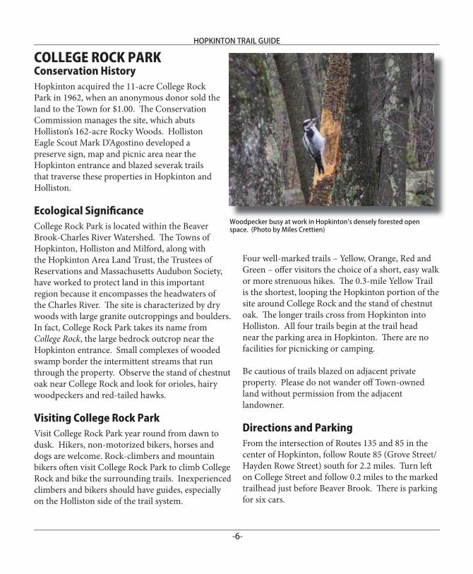
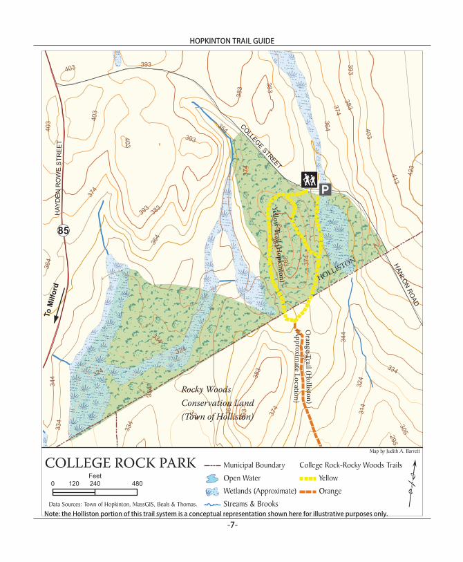
COLLEGE ROCK PARKConservation History Hopkinton acquired the 11-acre College Rock Park in 1962, when an anonymous donor sold the land to the Town for $1.00. Th e Conservation Commission manages the site, which abuts Holliston’s 162-acre Rocky Woods. Holliston Eagle Scout Mark D’Agostino developed a preserve sign, map and picnic area near the Hopkinton entrance and blazed severak trails that traverse these properties in Hopkinton and Holliston.
Ecological Signifi canceCollege Rock Park is located within the Beaver Brook-Charles River Watershed. Th e Towns of Hopkinton, Holliston and Milford, along with the Hopkinton Area Land Trust, the Trustees of Reservations and Massachusetts Audubon Society, have worked to protect land in this important region because it encompasses the headwaters of the Charles River. Th e site is characterized by dry woods with large granite outcroppings and boulders. In fact, College Rock Park takes its name from College Rock, the large bedrock outcrop near the Hopkinton entrance. Small complexes of wooded swamp border the intermittent streams that run through the property. Observe the stand of chestnut oak near College Rock and look for orioles, hairy woodpeckers and red-tailed hawks.
Visiting College Rock ParkVisit College Rock Park year round from dawn to dusk. Hikers, non-motorized bikers, horses and dogs are welcome. Rock-climbers and mountain bikers oft en visit College Rock Park to climb College Rock and bike the surrounding trails. Inexperienced climbers and bikers should have guides, especially on the Holliston side of the trail system.
Four well-marked trails – Yellow, Orange, Red and Green – off er visitors the choice of a short, easy walk or more strenuous hikes. Th e 0.3-mile Yellow Trail is the shortest, looping the Hopkinton portion of the site around College Rock and the stand of chestnut oak. Th e longer trails cross from Hopkinton into Holliston. All four trails begin at the trail head near the parking area in Hopkinton. Th ere are no facilities for picnicking or camping.
Be cautious of trails blazed on adjacent private property. Please do not wander off Town-owned land without permission from the adjacent landowner.
Directions and ParkingFrom the intersection of Routes 135 and 85 in the center of Hopkinton, follow Route 85 (Grove Street/Hayden Rowe Street) south for 2.2 miles. Turn left on College Street and follow 0.2 miles to the marked trailhead just before Beaver Brook. Th ere is parking for six cars.
Woodpecker busy at work in Hopkinton’s densely forested open space. (Photo by Miles Crettien)
HOPKINTON TRAIL GUIDE
-7-Note: the Holliston portion of this trail system is a conceptual representation shown here for illustrative purposes only.
!(85
364374
344
383
354
393
403
41333
4
324
314
305
423
295
393
324
403
324
334
403
324
403
383
393
383
364
364
334
344
383
364
374
393
374
393
403
364
334
374
383
403
383
393
374
334
COLLEGESTREET
HAY
DE
NR
OW
ES
TRE
ET
HANLON
ROAD
!Municipal Boundary
Open Water
Wetlands (Approximate)
Streams & Brooks
College Rock-Rocky Woods Trails
Yellow
Orange0 240 480120
Feet
IA
Data Sources: Town of Hopkinton, MassGIS, Beals & Thomas.
COLLEGE ROCK PARK
HOLLISTON
Rocky Woods Conservation Land(Town of Holliston)
ToM
ilfor
d
p¡
Orange T rai l (H
ol li st on)
Yellow Trail (H
opkinton)
(Approxim
ate Location)
Map by Judith A. Barrett
HOPKINTON TRAIL GUIDE
-8-
WHITEHALL STATE PARKConservation HistoryIn 1894, the Commonwealth of Massachusetts created Whitehall State Park (also known as Lake Whitehall and Whitehall Reservoir) by taking the land to create a new public reservoir. Two years later, the state dammed Whitehall Brook on Highland Street and fl ooded three ponds, to impound Lake Whitehall. For many years, Lake Whitehall served as a drinking water supply managed by the former Metropolitan District Commission (MDC), but it was eventually reclassifi ed as a reserve drinking water source for periods of severe drought. Today, the 920-acre Whitehall State Park surrounds and includes 575-acre Lake Whitehall. Th e Massachusetts Department of Conservation and Recreation (DCR) owns and manages the park.
Ecological Signifi canceFrom 75,000 to 20,000 years ago in the Pleistocene Epoch, a continental glacier advanced southward, covering Hopkinton and all of New England in ice a mile or more thick. As the glacier melted, large quantities of stratifi ed drift were deposited in streambeds and lakes. When glacial ice melted in the valley that now contains Lake Whitehall, sand and gravel accumulated on and alongside the ice. Today, remnants of these ice-contact outwash deposits exist as hills (kames) that form islands in the reservoir, and some sinuous ridges (eskers) along the lake’s western side. Th e Pond Street public water supplies also tap water-saturated sand and gravel deposits just south of Lake Whitehall.
At a later point during the retreat of the ice sheet, a large, glacial lake formed from melt water in the general vicinity of the present Whitehall Reservoir. As melt waters fl owed into the north
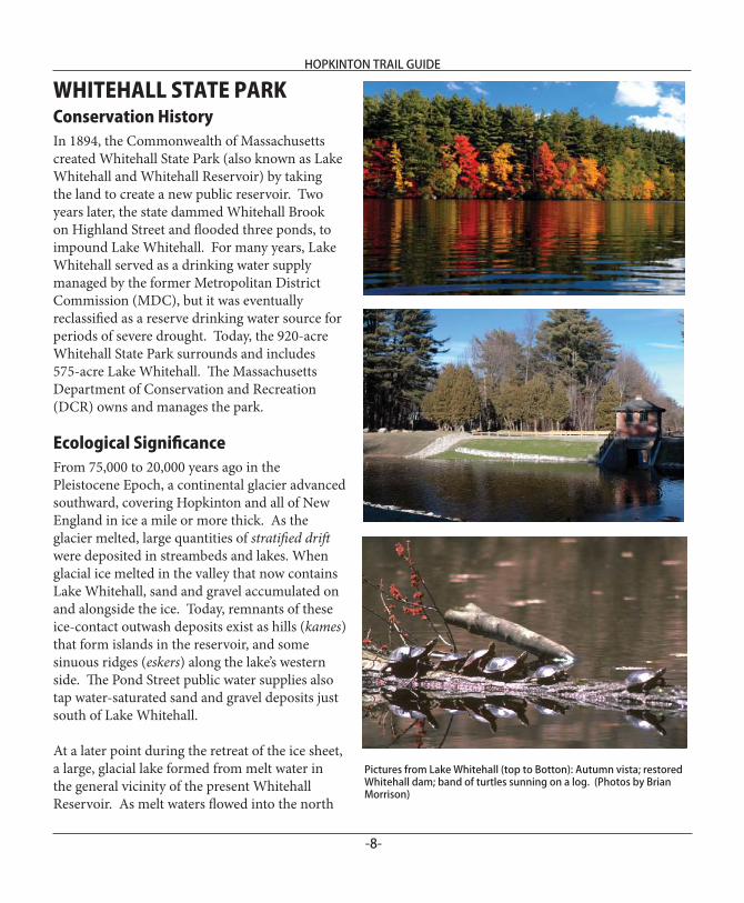
Pictures from Lake Whitehall (top to Botton): Autumn vista; restored Whitehall dam; band of turtles sunning on a log. (Photos by Brian Morrison)
HOPKINTON TRAIL GUIDE
-9-
hghghg
PON
DSTR
EE
T
WIN
TER
STR
EET
WOOD STREET
INTER
STATE495
SPRING
STREET
PIAZZALAN
E
ERIKA DRIVE
RALPH ROAD
EMM
ADRIVE
DO
NN
APA
SS
VALLEYWOOD ROAD
TIFFANY
TRAIL
WESTCOTT DRIVE
HIGHLAND STREET
STAG
ECO
ACH
WAY
PEGS WAY
INTER
STATE495
UV135
§̈¦495
383
344
374
36439
3
403
413 423
433
334
354
442
462
452
324
472
314
482
492501
511
305
521
295
531
364
344364
354
364
374
334
472
374
433492
374
354
403
423
423
344
442
344
452
501
324
354
482
423
344 531
374 383
334
364
354
403
383
364
374
354
433433
521
492
354
423
393
374
423
344
324
383
403
364
334
364
374
344374
442
383
314
334
354
364
442
462
364
383
403
344
383 383
354
413
344
364
374
511
393
403
354
374
354
364
383
364
354
452
511334
374
413
354
374
354
413364
354
344
354
344
334
354
344
32435
4
423
442
344
403
383
374
482
462
413
354
442
383
423
364
334
452
403
334
393
354
462
413
492
364
374
403
354
36442
339
3
344
383
423
364
364
374
344
334
452
374
295
344
393
442
354
383
403
364
393
354
364
344
374
344
374
354
472
403
364
364
403
354
334
344
501
482
482
354
334
364
334
383
423
334
393
334
354
452
442
433
462
531
452
374
364
364
334
364
403
501
472
403
334
452
334
334
383
374
472
442
374
364
393
354
344
374
354
433
364
393
354
472
Open Water
Streams & Brooks
Wetlands (Approximate)
Lake Whitehall Trail
hg NHESP Certified Vernal Pools
0 1,250 2,500625
Feet
IA
Data Sources: Town of Hopkinton, MassGIS.
WHITEHALL STATE PARK
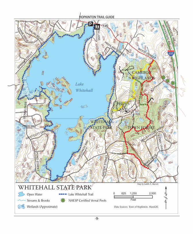
CAMERONHIGHLANDS
PHIPPSLAND
Lake Whitehall
p¡
!
TOWN FORESTWHITEHALLSTATE PARK
Map by Judith A. Barrett
HOPKINTON TRAIL GUIDE
-10-
end of the lake, a large delta of sand was deposited at the northwest corner. It can still be seen along Wood Street as a fl at terrace with homes and the Evergreen Cemetery, and the peninsula that extends into Whitehall Reservoir by Piazza Lane. When the ice retreated northward out of the Sudbury River basin, sediments of sand and gravel were deposited as ice melted out from beneath them. Th ese deposits formed the Town’s water-saturated aquifer at Fruit Street and the area surrounding Whitehall Brook.
Whitehall State Park is located within the Whitehall Brook-Sudbury River Watershed. Southern New England hardwood forest with pockets of shrub and wooded swamp characterize the landscape around Lake Whitehall. Look for vernal pools in the ice block depressions surrounding the lake, and beaver and muskrat along the shoreline. In addition, Lake Whitehall contains many fl oating islands (referred to locally as “quags,” which is probably short for quagmire). Loosely tethered to the lake bottom in shallow areas, these islands exhibit a vegetation community similar to that found in quaking bogs. Sphagnum moss forms the basis of the islands, and as it accumulates, species such as red maple, larch, black spruce, bog rosemary, leatherleaf, waterwillow, and Virginia chain fern take root. Poison sumac, a gangly shrub, abounds on the islands at Lake Whitehall. Be careful if you are kayaking.
Th e Massachusetts Natural Heritage and Endangered Species Program (NHESP) has designated Whitehall State Park, including the reservoir, as Core Habitat and the extensive cedar swamp and associated wetlands to the southwest as Critical Supporting Watershed. Th e cedar swamp is part of a Massachusetts Area of Critical Environmental Concern (ACEC) because of the quality and uniqueness of its natural and historical resources. Take note of a fi ne example of Atlantic
white cedar swamp on private land in the area between Spring and Pond Streets opposite Lake Whitehall. NHESP has also observed several rare dragonfl y species at Lake Whitehall.
Whitehall State Park also has historically signifi cant resources nestled in the woods. During the fi rst half of the nineteenth century, before Lake Whitehall was impounded, a resort area developed around the supposed healing springs and mineral baths along Whitehall Brook in the vicinity of Norcross Road off Spring Street. Visitors came by stagecoach to the Hopkinton Hotel on Spring Street across from present-day Lyford Road. Extant spring structures remain in the woods off the end of Norcross Road.
Visiting Whitehall State ParkVisit the preserve year round from dawn to dusk. Hikers, non-motorized bikers, horses and dogs are welcome. An undulating, 6.2-mile trail marked with “State Park” blue blazes loops around Lake Whitehall through mixed deciduous woods and off ers frequent views of the lake. Look for prominent glacial erratics (boulders) and extant foundations, chimneys and stone walls along the trail. Th is fairly shallow lake is an excellent place to fi sh. Th e Commonwealth allows canoes, kayaks and small power boats. Th ere are no lakeshore beaches and camping facilities. Be cautious of trails blazed on private property. Please do not wander off state land without permission from the property owner.
Directions and ParkingFrom the intersection of Routes 135 and 85 in the center of Hopkinton, follow Route 135 (Main Street/Wood Street) west for 2.9 miles. Th e Commonwealth’s boat ramp and 50-car parking lot is on the left just past Piazza Lane. Additional parking is available along Winter, Spring and Pond Streets. Th e trailhead begins at the parking lot on Wood Street.
HOPKINTON TRAIL GUIDE
-11-
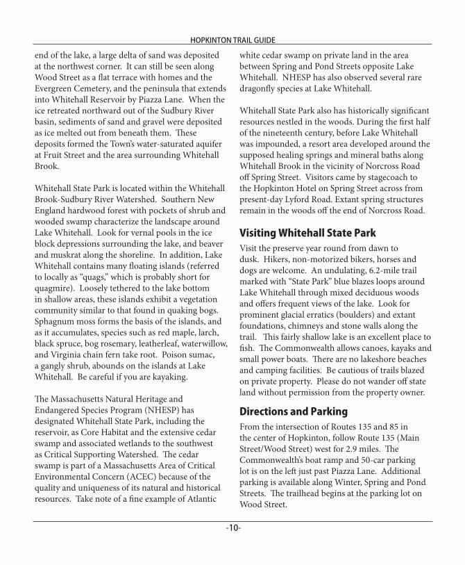
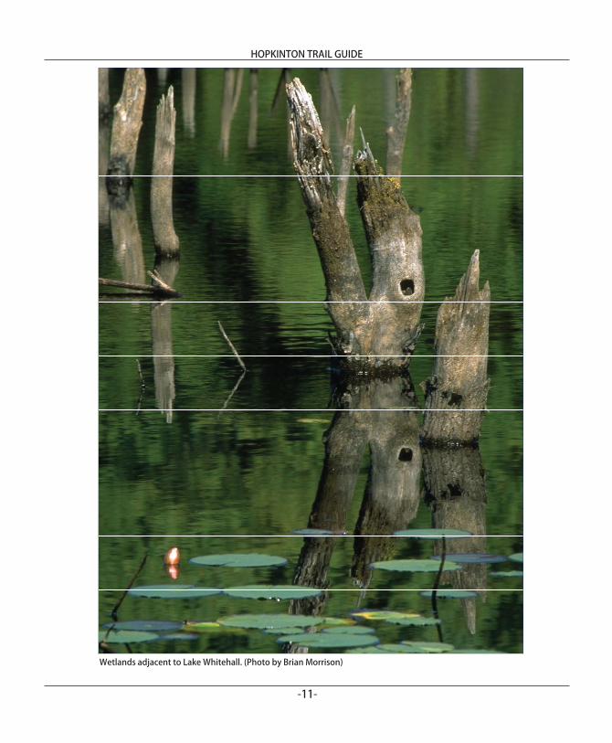
Wetlands adjacent to Lake Whitehall. (Photo by Brian Morrison)
HOPKINTON TRAIL GUIDE
-12-
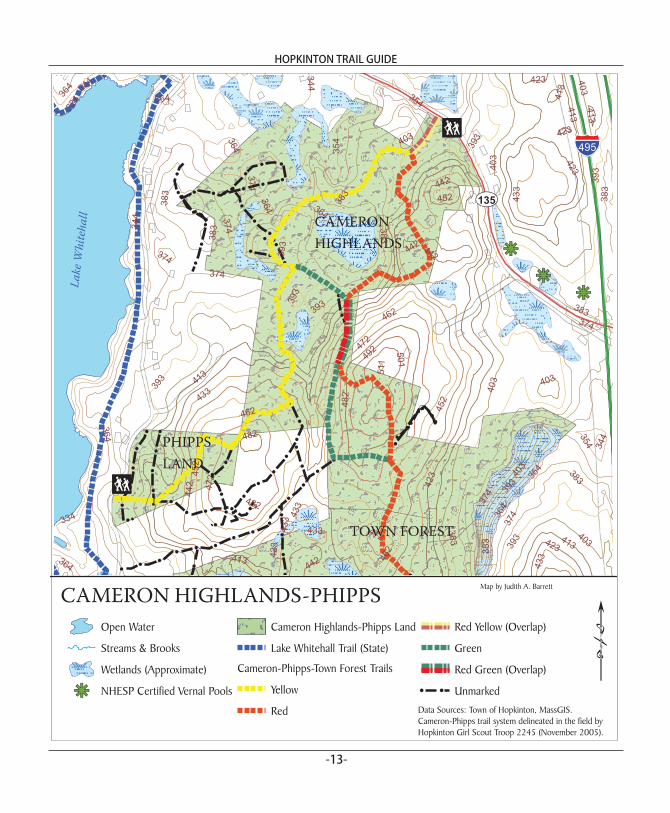
CAMERON HIGHLANDSPHIPPS PROPERTY Conservation HistoryCameron Highlands and the Phipps Property off er an interconnected trail system that links to other trails in the Town Forest. Located east of Winter Street opposite Lake Whitehall, the 126-acre Cameron Highlands property was purchased by the Town in 2001 and the 7-acre Phipps Property, in 2003. Th ese acquisitions were supported by the Open Space Preservation Fund and the Community Preservation Act. Th e Hopkinton Open Space Preservation Commission manages both sites. Ecological Signifi canceCameron Highlands and the Phipps Property are located within the Whitehall Brook-Sudbury River Watershed, between Wood and Winter Streets east of Lake Whitehall. A dense, southern New England hardwood forest covers both sites, with pockets of wooded swamp that help to protect the water quality in Lake Whitehall. Virtually all of the land in this part of Hopkinton functions as Supporting Natural Landscape for habitat areas (Core Habitats) that support rare species and a variety of natural communities.
Visiting Cameron Highlands-Phipps Visit these properties year round from dawn to dusk. Hikers, non-motorized bikers, horses and dogs are welcome. Cameron Highlands off ers a variety of recreation opportunities. Rolling hills characterize the landscape, and there are wide trails for hiking, snowshoeing, cross-country skiing and horseback riding. Elevations range from about 350 to 510 feet Mean Sea Level (MSL). Hopkinton Eagle Scout Nick Nigro blazed a fi gure-eight trail and the trailhead is marked “Cameron Highlands Trail” on Wood Street. Hopkinton Girl Scout Troop #2245
has also assisted with marking trails throughout the property. Look for granite outcroppings and hemlock groves. On the Phipps land, a short, easy 0.5-mile trail traverses the site and connects to trails at Cameron Highlands and the Town Forest.
Both sites abut private property. Cameron Highlands shares a boundary with a private horse farm with an agility course, and the Phipps family still owns land on Winter Street, including land with blazed trails. Please do not wander off Town-owned property without permission from the adjacent landowner.
Directions and ParkingTo reach the Cameron Highlands trail head, follow Route 135 (Main Street/Wood Street) west for 2.1 miles from the intersection of Routes 135-85 in Hopkinton center. Th e trail head is on the left at the curve in the road aft er 157 Wood Street. Access to the Phipps property is on Winter Street, a left turn off Route 135 approximately 0.3 miles from the entrance to Cameron Highlands. Follow Winter Street for 0.9 miles. Th e Phipps property is on the left . Visitors may park along Winter Street.
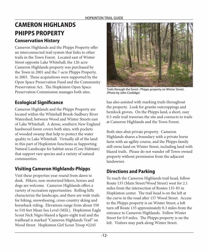
Trails through the forest : Phipps property on Winter Street. (Photo by John Coolidge)
HOPKINTON TRAIL GUIDE
-13-
!
!
!!
!
!
!!
!
!
!
!
! !
!
!
!
!
!
!!
!
!
!
!
!
!
!
!
!
!
!!
!!
!
!
!
!
!
!!
!
!!
!
!
!!
!!
!!
!
!!
!
!
!
!
!!
!
!
!
!
!
!
!
!
!
! !
!!
!!
!
!
!!
!
!
!
! !! !
!
!
!
!
hghg
hg
354
364
374383
393
344
334
403413
423
433
442
452
462
472
482
492 501
511
403
383
482
383
423
374
433
403
364
393
383
364
383
383
472
344
423
364
374
433
403
393
433
374
472 40
3
344
413
413
364
374
364
413
433
364482
46242
3
403
403
452
374
413
442
393
462
442
383
442
442
383
393
354
364
354
393
393
433
374
383
344
423
334
393
413
364
423
452
§̈¦495
UV135
Open Water
Streams & Brooks
Wetlands (Approximate)
hg NHESP Certified Vernal Pools
Cameron Highlands-Phipps Land
Lake Whitehall Trail (State)
Cameron-Phipps-Town Forest Trails
Yellow
Red
Red Yellow (Overlap)
Green
Red Green (Overlap)
! ! UnmarkedData Sources: Town of Hopkinton, MassGIS.Cameron-Phipps trail system delineated in the field byHopkinton Girl Scout Troop 2245 (November 2005).
CAMERON HIGHLANDS-PHIPPS
CAMERONHIGHLANDS
PHIPPSLAND
Lake
Whi
teha
ll
p¡
!
TOWN FOREST
p¡
Map by Judith A. Barrett
HOPKINTON TRAIL GUIDE
-14-
HOPKINTON AREA LAND TRUSTTh e Hopkinton Area Land Trust (HALT) is a non-profi t conservation organization that works with the Town to protect open space through fee acquisition and conservation restrictions. HALT hopes to develop a greenway around Hopkinton. Toward this end, HALT has helped to protect 85 acres at Brook Hollow, Deer Run, Wiley Woods and Hopkinton Highlands I, and plans to protect another 60 acres at Hopkinton Highlands II. HALT opens its land to the public for passive recreation such as walking, hiking, snowshoeing and cross-country skiing. Its volunteers manage almost 600 acres of open space that Hopkinton has saved mainly as a result of OSLPD plans approved by the Planning Board.
Brook HollowTh e DeGozzaldi Family donated the 12-acre Brook Hollow site to HALT. Hopkinton Eagle Scout Dan Newbrander blazed the 0.5 mile trail that memorializes Susan M. DeGozzaldi. Look for two majestic American beech trees on this property. Horses are welcome at this preserve, which is bordered by Frankland Road and Cross Street.
Deer RunTh e Lakeside Construction Company gave 17 acres at Deer Run to HALT. A particularly beautiful 1.0 mile trail named in memory of Amy and Rolf Andersen traverses the property. It begins at a trail head on Fawn Ridge Road and exits at the opposite end of the cul-de-sac. Northborough Eagle Scout Eric Pfeifer blazed the trail and constructed the footbridge, two benches, several birdhouses and signs naming the plant species. Parking is available on Fawn Ridge Road. Horses are welcome.
Wiley WoodsDeveloper Ron Roux donated 16 acres on Frankland Road near the Ashland town line to create Wiley
Woods. A 0.8-mile trail takes visitors past several vernal pools and southern New England hardwood forest. Th e Wiley Woods trailhead is on Frankland Road about 200 feet east of Brook Hollow. A small parking area is located at the trailhead.
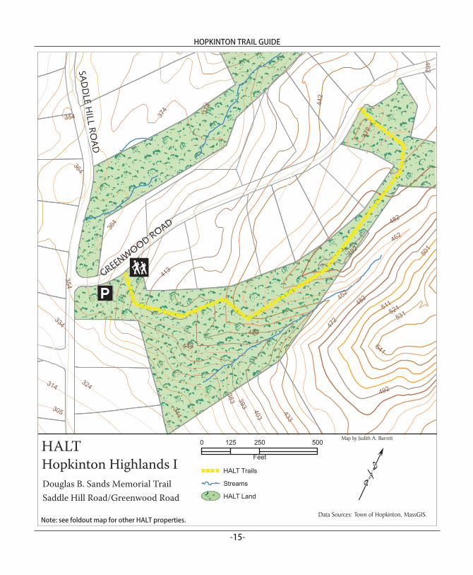
Hopkinton Highlands ITh e Lodge Corporation contributed 40 acres to HALT to create Hopkinton Highlands I at the intersection of Greenwood Road and Saddle Hill Road. Th e 0.75 mile Douglas B. Sands Trail begins at the intersection. Mr. Sands, a long-time Hopkinton resident and noted ornithologist, was recently named Man of the Year by the Massachusetts Audubon Society. Look out at the scenic Chuck Zettek Overlook on Greenwood Road, which provides a 10-12 mile view to the west. Parking is available behind the boulder at the trailhead.
HALT’S GoalsTo preserve, protect, conserve, and enhance the natural resources within and around the town of Hopkinton, Massachusetts, including water resources, marshlands, swamps, woodlands, underground water supplies, open spaces, land areas of historical signifi cance, and wildlife habitat, in order to maintain and improve the quality of life in the town of Hopkinton for present and future generations.
To educate the public in the area of conservation, ecology, forestry practices, wildlife preservation and land use planning in order to protect open space, plant, and animal life therein.
To encourage and facilitate the use of land conservation, recreation, and wildlife preservation by cooperating with the town of Hopkinton, its elected offi cials and committees, Hopkinton landowners, and other individuals and organizations having similar purposes.
To acquire, hold, maintain, and enforce such conservation and preservation restrictions, easements and other interests in land, water areas, and structures as it deems appropriate and in the public interest.
HOPKINTON TRAIL GUIDE
-15-
364
374
383
452
442
433
423
413
403
393462
354
472
344
334
324
482
492
501
511
314
521531
541
305
462
364
354
472
374
413
482
492
GREENWOOD ROAD
SAD
DLE
HILL
ROA
D
IA
p¡
HALT
Douglas B. Sands Memorial Trail Saddle Hill Road/Greenwood Road
Hopkinton Highlands I !0 250 500125
Feet
HALT Trails
Streams
HALT Land
Data Sources: Town of Hopkinton, MassGIS.
Map by Judith A. Barrett
Note: see foldout map for other HALT properties.
Hopkinton Open Space Preservation CommissionHopkinton Trail Guide
Hopkinton Open Space Preservation Commission
c/o Hopkinton Conservation Commission
18 Main Street
Hopkinton, MA 01748
BROOK HOLLOWHopkinton Area Land Trust