town of gosnold - mass.gov€¦ · plan. the effective approved plan in 2018 is dukes county...
TRANSCRIPT

TOWN OF GOSNOLD
Cuttyhunk Harbor Entrance on April 17, 2018
Navigation Encroached by Sand
COMMUNITY RESILIENCE BUILDING WORKSHOP SUMMARY OF FINDINGS
JUNE 2018
Summary Prepared by Jo-Ann Taylor, Martha’s Vineyard Commission

2
TOWN OF GOSNOLD COMMUNITY RESILIENCE BUILDING WORKSHOP
SUMMARY OF FINDINGS Overview The Town of Gosnold includes the entire Elizabeth Islands chain. The larger islands are: Nonamesset, Uncatena, Weepecket, Naushon, Pasque, Nashawena, Penikese and Cuttyhunk. According to the 2010 census, Gosnold had a year ‘round population of 52 on an area of 13 square miles of dry land, with a density of 4 persons per square mile. The Town participated in the Commonwealth of Massachusetts’ Municipal Vulnerability Preparedness (MVP) program to promote resiliency. Gosnold has been and continues to be dedicated to community resiliency. Gosnold participated in hazard mitigation planning to produce a first and then an updated Hazard Mitigation Plan. The effective approved plan in 2018 is Dukes County Multi-Jurisdiction Hazard Mitigation Plan Update, 2015. Upon undertaking the MVP program, Emergency Manager Seth Garfield and Selectman Gail Blout conferred with MVC staff Jo-Ann Taylor (Coastal Planner) and Chris Seidel (GIS) to map out the workshop planning, starting with a telephone conference with future workshop participants, on March 6. Participants chose to build on the Hazard Mitigation Plan and include more emphasis on climate change, in keeping with the MVP program; to focus on the most populated islands of Cuttyhunk and Naushon; and to hold 2 workshops in April and a Listening Session in June. Workshops were conducted using Community Resilience Building (www.comunityresiliencebuilding.com). The workshops’ central objectives were:
Define top local natural and climate-related hazards of concern;
Identify existing and future strengths and vulnerabilities;
Develop prioritized actions for the Community;
Identify immediate opportunities to collaboratively advance actions to increase resilience. The first workshop was held on Cuttyhunk, April 17; and the second on April 24 in Woods Hole. The Summary of Findings was presented to the public on June 11, 2018 on Cuttyhunk. Top Hazards and Vulnerable Areas: In discussing top hazards and vulnerable areas, the workshop reviewed material on the subject in Dukes County Multi-Jurisdiction Hazard Mitigation Plan Update, 2015, and new material from Massachusetts Climate Change Projections, 2017. There was quick consensus that the main concern is for keeping navigation and waterfront facilities functioning in spite of rising sea level and the threat of hurricanes. Wildfire and stormwater round out the list. Top Hazards
Sea Level Rise
Hurricane
Drought/Wildfire
Rainstorms
3
Areas of Concern
Settlement is centered on two islands; the westernmost island of Cuttyhunk, and Naushon, the largest island in the chain and the easternmost. Ferry service for passengers and freight (no cars) is provided year ‘round between Cuttyhunk and New Bedford and in summer from Menemsha. Ferry service for passengers and freight between Naushon and nearby Woods Hole is provided year ‘round. Protection and functionality of harbor facilities are essential for the well-being of the residents.
o On Cuttyhunk, the main Entrance Channel is the most critical. It is vulnerable to overwash in hurricanes and other storms.
Barges Beach (1)1 is vulnerable to damage in severe weather, and supplies sand that blows or overwashes into the entrance channel.
On the north side of the channel, Copicut Neck protects the channel from Nor’easter storms, but is itself vulnerable to those storms and provides sand to be blown and overwashed into the channel.
On the north side of the harbor, Church’s Beach protects the harbor and is vulnerable to storms.
Waterfront facilities including docks (2, 3, and 6), barge ramp (3) and fuel and trash facilities (2, 4) are all vulnerable to sea level rise and to hurricanes.
o On Naushon; The Ferry Dock (5) and the Uncatena Dock (1) are vulnerable to storms and to sea level
rise. There are several bridges (2, 8, and 10) and a causeway (7). Of these, the middle one of
three between Naushon and Nonamesset is a causeway that is regularly overwashed in storms and will be overwashed more frequently with higher sea level rise.
The barge ramp (7) is vulnerable to storms and sea level rise, and is surrounded by lowlands.
Cuttyhunk is served by a public water supply, which is vulnerable to contamination.
Cuttyhunk is vulnerable to wildfire, as identified in the Cuttyhunk Wildfire Management Plan.
Vulnerable roads were identified and mapped. On Cuttyhunk, the waterfront roads are vulnerable to sea level rise and to storms. The road to the Water Supply Control is vulnerable to rainstorm washout, as is Tower Road and the roadway adjacent to the infiltration pond. On Naushon, the critical access between Upper Wharf and downtown is vulnerable to rainstorm washout.
Penikese School serves a vulnerable population, as does the Cuttyhunk School. As of 2018, Penikese School is closed, but is expected to reopen.
A number of private homes are vulnerable to sea level rise and to storms.
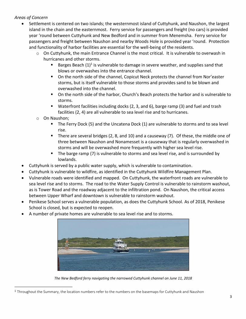
The New Bedford ferry navigating the narrowed Cuttyhunk channel on June 11, 2018
1 Throughout the Summary, the location numbers refer to the numbers on the basemaps for Cuttyhunk and Naushon

4
Cuttyhunk ferry dock (left), fuel dock (center) and barge ramp (right)
fuel storage fish dock
Church’s Beach
Barges Beach
Current Concerns and Challenges Presented by Hazards
Consensus was achieved quickly on the primary concern of navigation and water transport being disrupted by climate-related increases in sea level and intensity of hurricanes. Wildfire and road washouts present challenges as articulated in Dukes County Multi-Jurisdiction Hazard Mitigation Plan Update, 2015, with concurrence in the 2017 workshops. Specific Categories of Concerns and Challenges
Disruption of Navigation and Water Transport is the most serious concern. Sea level rise and storms threaten the entrance channel to Cuttyhunk and the waterfront infrastructure for both Cuttyhunk and Naushon. Public health and safety, and economic stability depend on access to the harbor and waterfront facilities.

5
Wildfire is expected to increase in severity along with drought, as climate change brings about changing rainfall patterns.
Road washouts are an increasing concern as climate change progresses. Climate change is seen now and in the future to modify rainfall so that more short-term periods of drought are punctuated by increasingly severe heavy rainstorms. As hurricanes increase in intensity, washouts from storm surge could disrupt the waterfront roads.
Strengths and Assets for the Town of Gosnold The small and close community is the main strength of Gosnold. Knowledgeable leadership and highly effective personnel and volunteers keep a step ahead of trouble. The response to climate change is no different.
NFIP – Gosnold participates in FEMA’s National Flood Insurance Program. Floodplain by-laws have been adopted, ensuring subsidies in flood insurance for seven properties.
Cuttyhunk:
The main Entrance Channel is the most critical asset for Cuttyhunk. Maintenance dredging is performed by the USACOE (Army Corps of Engineers). Emergency dredging could also be provided, but not likely to be done in a timely manner.
o Barges Beach (1) protects the channel from bad weather from the south. o On the north side of the entrance, Copicut Neck protects the harbor from damage by Nor’easters. o On the north side of the harbor, the barrier beach known as Church’s (18) protects the harbor from
Nor’easters.
Waterfront facilities are critical for emergency response, for serving passengers and for freight. o The Fish Dock (6) was recently rebuilt. The Ferry Dock (3) is new. The Fuel Dock (2) was recently
redecked. o The Barge Ramp (3) is critical for some supplies, particularly if the docks are damaged. o The waterfront transfer station (4), propane and gasoline tanks (4), and toilet facilities (7) are all
water-dependent uses that function well.
Town Hall (11) – This is the site for emergency operations, a MassCare Center; houses a microwave, fridge and small hot water heater.
Church (19) – The privately-owned Church serves as a MassCare center.
Cuttyhunk School (12) – The school serves as a backup MassCare center; serves a vulnerable population in its day-to-day function.
Wildfire Management Plan – Cuttyhunk has adopted and utilizes a wildfire management plan. Cuttyhunk is an NFPA Federal Firewise Community. Ongoing firewise measures include mowed firebreaks, prescribed burning; road clearance and/or widening.
A number of agreements are in place for response from larger communities, most of them official Memoranda of Agreement (MOUs). There are MOUs for Police with New Bedford and with all the Martha’s Vineyard towns; for Fire and EMS with New Bedford and Oil spill equipment is kept on Cuttyhunk. Training is kept up.
Cuttyhunk’s electrical supply and distribution, Power House (10), and solar array (13) are essential services that are secure.

6
Cuttyhunk’s airstrip (14) is secure, however private, and essential for freight and emergency response, particularly if the harbor becomes impassable.
Cuttyhunk’s helipad (9) is essential for emergency response.
Cuttyhunk’s public water supply is a critical service and not vulnerable as long as care is taken to keep from saltwater intrusion.
Naushon:
The Ferry Dock (5) was redecked about 15 years ago. Piling work was also done.
Three bridges (2, 8, 10) and a causeway (9) are structurally sound.
The barge ramp (7) is in good condition.
A number of agreements are in place for response from larger communities, most of them official Memoranda of Agreement (MOUs). There are MOUs for Police with New Bedford and with all the Martha’s Vineyard towns; for Fire and EMS with New Bedford and Dartmouth; Naushon is on the Dukes County pager system. Naushon has in informal agreement for EMS services with Falmouth, and had access to a brush breaker that is no longer available.
Naushon has landing sites for helicopter response, particularly important if the harbor is iced in.
Oil spill equipment is kept on Naushon. Training is kept up.
Naushon’s generator (4) and solar array (3) are in good condition. Strategies to Improve Resilience in Gosnold The workshops served to review and update the mitigation proposed in Dukes County Multi-Jurisdiction Hazard Mitigation Plan Update. The highest priority actions are to protect the harbor accesses and waterfront facilities. Wildfire remains a concern, and Firewise treatments remain prominent in mitigation, along with partnerships in response. Stormwater remains a concern and the use of the 25-year rainstorm in calculations remains prominent. Highest Priority
The highest priority for Cuttyhunk is to protect Cuttyhunk Entrance Channel and keep it open for navigation.
o The highest priority for protecting the Entrance Channel is to maintain Barges Beach by beach nourishment, dredging and reconfiguration.
Next priority is elevation of the docks on Cuttyhunk (Fish Dock (6), Ferry Dock (3) and Fuel Dock (2)) and on Naushon (Ferry Dock (5) and Uncatena Dock (1)). Elevation should be included in future maintenance and repair projects.
Wildfire management on Cuttyhunk is a high priority and ongoing. The Wildfire Management Plan includes firewise treatments, mowed firebreaks, prescribed burning, road clearance and/or widening.
Protecting the public water supply on Cuttyhunk is a high priority. The sole source aquifer should be protected. A groundwater protection district bylaw is an important next step, and can be accomplished without outside funding.

7
Moderate Priority Cuttyhunk
In order to protect the harbor’s Entrance Channel, modify the east end of Barges Beach (Barges Beach East), outside of the limits of the designated barrier beach, by reconfiguration and or armoring.
In order to protect the harbor’s Entrance Channel, modify Copicut Neck jetty by elevation and/or extension of the jetty.
In order to protect the harbor, enhance Church’s Beach (18). Consider participation in a future pilot program to mine sand in the vicinity, for beach nourishment.
The barge ramp (3) near the Ferry Dock is vulnerable to sea level rise, and plans should be made and executed for retreat.
The transfer station (4) is properly sited at the waterfront, near transportation. In the event of a hurricane, the dumpsters are moved to higher ground. A mobile trailer or truck is needed for moving the dumpsters and contents out of harm’s way
A number of waterfront roads, providing access to waterfront facilities, have been identified as vulnerable to sea level rise and hurricane inundation. Because retreat is not an option, elevation is the obvious choice for keeping the access. For other roads, such as Cemetery Road, retreat should be evaluated as perhaps a better option than elevation.
A number of homes are vulnerable to sea level rise and to hurricane storm surge. Gosnold participates in the NFIP (subsidized flood insurance through the National Flood Insurance Program), which program requires elevation for new construction and for homes damaged more than 50%. As sea level rises, the heights needed for resilient building will conflict more and more with the height restrictions of Gosnold’s traditional New England zoning. Zoning must be reviewed with consideration given to elevating vulnerable structures, particularly the waterdependent facilities that can’t be drawn back to higher ground.
Rainwater washes through the powerhouse. As rainstorms continue to increase in severity, this situation will only deteriorate. An engineered solution is needed, one that uses the 25-year rainstorm in place of the 10-year rainstorm typically used to size facilities.
A mobile generator of about 7500 W, and connections, should be provided to share between Town Hall and Cuttyhunk Church for emergencies.
Naushon
Naushon has a number of helicopter landing sites for emergencies. One site should be designated, such as Mansion House Meadow, in order to avoid confusion.
The barge ramp (7) is vulnerable to sea level rise and surrounded by lowlands. Retreat must be planned and executed.
The causeway (9) needs to be elevated, in order to accommodate sea level rise. Overwash occurs there, and will increase.
Naushon had an informal arrangement for a small brush breaker from Falmouth for emergencies. Falmouth no longer has the truck. A new arrangement should be discovered and secured.

8
Lower Priority
As the jetty off Copicut Neck becomes more and more submerged by sea level rise and in hurricanes, there will be less and less protection for the Entrance Channel into Cuttyhunk Harbor. The jetty could be elevated, extended or reconfigured.
There needs to be a plan for retreat for the propane tanks (4) at the Cuttyhunk waterfront, as sea level rises.
The Bulkhead (17) protecting the Bog keeps saltwater intrusion out of the Cuttyhunk Water Supply. As sea level rises, the bulkhead will need a plan for retreat designed and executed.
As sea level rises, Cuttyhunk’s Helipad ((9) will need a plan for retreat designed and executed.
On Cuttyhunk, roads vulnerable to heavy rainstorms were identified: Road to the Water Supply Control, Tower Road, and the corner of Broadway and Bayview Drive (at the infiltration pond). An engineered solution is needed, one that uses the 25-year rainstorm in place of the 10-year rainstorm typically used to size facilities.
On Naushon, the road (6) from Upper Wharf (5) to Downtown, connecting with waterfront transportation and emergency response, is vulnerable to rainstorms and will further deteriorate as rainstorms become more severe. An engineered solution is needed, one that uses the 25-year rainstorm in place of the 10-year rainstorm typically used to size facilities.
Next Steps
Several strategies are regulatory in nature and will be addressed through the same mechanisms as other bylaws. Strategies will be reviewed, public input engaged, hearings held, and votes taken.
o A groundwater bylaw will be pursued. Samples of text from Martha’s Vineyard towns will be the first review step.
o Resolving the dichotomy between elevation for resilience and the traditional look of low buildings will mean undertaking discussion, ideally with visual samples; and will likely result in zoning amendments regarding height.
Several strategies focus on communication. For example, the confusion over helicopter landing sites on Naushon will be resolved by naming one, such as the Mansion House Meadow, and informing all response parties.
Several strategies require funding for design and construction. A number of avenues for funding will be explored. Because Gosnold’s hazard mitigation plan, Dukes County Multi-Jurisdiction Hazard Mitigation Plan Update 2015, is up-to-date and approved; the Town is eligible for 75% funding for FEMA mitigation grants. The Town hopes to achieve MVP status and secure State funding thereby. Other potential sources include Seaport Council and other awards and earmarks.
The work done by the Town through the MVP project is expected to be helpful in a number of other planning efforts:
o The Town has an active Long Range Planning Committee that will be able to use the strategies and priorities for guidance. Should a Capital Program Committee be established, the same guidance should be very helpful.
o The Town is developing an Open Space Plan, which may also use the MVP results in its development.
o In 2018-9, Dukes County Multi-Jurisdiction Hazard Mitigation Plan Update 2015 will be updated for submission in its 5-year approval cycle. The MVP project has provided most of what the Town needs for that submission.

9
Workshops Participants
Gail Blout; Chairman of Board of Selectmen
Seth Garfield; Emergency Management Director, Fire Chief
Beth Colts; Naushon resident and Managing Trustee
George Isabel; Police Chief, Harbormaster
Wayne Perrier; Electric Company Supervisor, Assistant Fire Chief
Asa Lombard IV; Solid Waste Manager, Shellfish Warden
Russell Wright; Water Manager
Jo-Ann Taylor and Chris Seidel; MVC staff
Presentation of Summary of Findings, June 11, 2018 Participants Jo-Ann Taylor Dan Doyle Barry Stringfellow Chris Seidel Gail Blout Sarah Berry Dix Leeson Seth Garfield Tim Buckeridge George Shaw Dillon Storek Jeff Spear Acknowledgement Funding provided by Massachusetts Municipal Vulnerability Preparedness (MVP) Program Attachments
Base maps for Cuttyhunk and Naushon, finalized from notes during the Workshops
Charts of Strengths, Vulnerabilities, Major Hazards, and Prioritized Strategies to Enhance Resiliency (ID numbers for facilities correspond with the ID maps on the base maps)
Vulnerability Maps from Dukes County Multi-Jurisdiction Hazard Mitigation Plan Update 2015 and Cuttyhunk Wildfire Management Plan
Climate Change date presented from Massachusetts Climate Change Projections 2017


Community Resilience Building Risk Matrix Town of Gosnold www.CommunityResilienceBuilding.org
H-M-L priority for action over the Short or Long term (and Ongoing) Top Priority Hazards (tornado, floods, wildfire, hurricanes, earthquake, drought, sea level rise, heat wave, etc.)
Priority Time
V = Vulnerability S = Strength
Features Location Ownership V or S
Infrastructural Cuttyhunk
Entrance Channel critical)USACOE responsible
for maintenance and
emergency dredgingS,V Protect the Channel! Protect the Channel!
H - the most critical of all
Ongoing
Wharves and waterfront infrastructure (critical)Cuttyhunk Fish Dock (6) (redecked), Ferry Dock (3) (new build), Fuel Dock and tanks (2)(redecked)
Town, Fuel leased to Ralph Packer
S,V Elevate as maintenance and repairs are done Elevate as maintenance and repairs are done H Ongoing
Barge Ramp near Ferry Dock (critical) Waterdependent, waterfront (3) Town S, V Retreat Retreat M L
Waterfront toilet facilities (critical) Waterdependent, waterfront (7) Town S, V Elevate and/or retreat Elevate and/or retreat L L
Transfer Station (critical)Waterdependent, waterfront (4) Town S, V
Need a means to move the dumpsters ahead of a hurricane; mobile trailer or truck M S
Propane tanks (critical)Waterdependent, waterfront (4)
Town-owned land, leased to vendor
S, V Retreat L L
Electrical Supply and Distribution, Power House (critical)
Powerhouse (10) Shutoffs to vulnerable areas Town SRainwater washes through Power House; needs correction M L
Solar Array (critical) 13
Town-owned equip. on leased land, ROW to Power House
S
Roads Vulnerable to SLR, Hurricane (critical) Cuttyhunk - waterfront roads as mapped Town, Private VElevate routes to waterfront, consider retreat elsewhere (Cemetery Road, e.g.)
Elevate routes to waterfront, consider retreat elsewhere (Cemetery Road, e.g.)
M L
Homes Vulnerable to SLR, Hurricane Private VPrepare zoning for elevation conflicts with height restrictions.
Prepare zoning for elevation conflicts with height restrictions.
M S
Rainstorm Washout - Cuttyhunk (critical)
Road to Water Supply Control (critical) (15), Tower Road (critical), Corner of Broadway and Bayview (infiltration pond)
Town VEngineered Solution using 25-yr rainstorm
L S
Public Water Supply (critical) 16 Town SProtect the Sole Source Aquifer; Groundwater
Protection Bylaw, e.g.H S
Bulkhead to bog (critical) Protects pond from seawater intrusion to well (17) Town S,V Develop and execute a plan for retreatL L L
Airtstrip (critical) 14 Private S
Helipad (critical) 9 Town S,V retreat L L
Infrastructural Naushon
Naushon Ferry Dock at Upper Wharf (critical) Redecked ~15 years ago, piling work too (5) S,V Elevate as maintenance/repair work is done Elevate as maintenance/repair work is done H ongoing
Uncatena Dock (1) (critical)Private S,V Elevate as maintenance/repair work is done Elevate as maintenance/repair work is done M L
Road Vulnerable to Rainstorm Washout - (critical)
Upper Wharf to downtown (access to water transport) (6)
Private VEngineered Solution using 25-yr rainstorm
L S
Bridges, one of which is a causeway (critical)The causeway (9) is stable, but regularly overwashed. The bridges (2,8,10) are in good shape.
Private S,V Elevate causeway Elevate causeway M S
Solar Array (critical) 3 Private S
Generator (critical) 4 Private S
Barge Ramp (critical) Surrounded by lowlands (7) Private S,V Retreat M L
Short Long Ongoing
Sea Level Rise Hurricane Drought, Wildfire RainstormsH - M - L

Community Resilience Building Risk Matrix Town of Gosnold www.CommunityResilienceBuilding.org
Top Priority Hazards (tornado, floods, wildfire, hurricanes, earthquake, drought, sea level rise, heat wave, etc.)
H-M-L priority for action over the Short or Long term (and Ongoing) Priority Time
V = Vulnerability S = Strength
Features Location Ownership V or S
Societal
Town Hall - emergency ops center, MassCare Center (critical) (microwave, fridge, small hot water heater; 120 V) (furnace 220 V)
11 Town Smobile generator and connections (~7500W)
M S
Church - MassCare Center (critical) 19 Private Sshare mobile generator, install
connectionsM S
Cuttyhunk School (critical- vulnerable population, backup MassCare Center)
12 Town S,V
Penikese School and Dock (critical- vulnerable population)
US Fish & Wildlife
V
Wildfire Management Plan - An NFPA Federal Firewise Community
S
Firewise treatments, Mowed firebreak,
Prescribed burning, Road clearance and/or
wideningH Ongoing
Participation in NFIP (7 subsidized policies) S
MOUs for Police with New Bedford, all MV PDs S
MOUs for Fire, EMS with New Bedford, Dartmouth S
Naushon - informal response by Falmouth EMS SNeed a new arrangement for small brush truck (was Falmouth to Naushon)
M S
Naushon on Dukes County pager system S
Naushon - Helicopter rescue (particularly if harbor is iced in)
Private SNeed to designate a single site, such as Mansion House Meadow
Need to designate a single site, such as Mansion House Meadow
M S
Short Long
Ongoing
Sea Level Rise Hurricane Drought/Wildfire RainstormsH - M - L

Community Resilience Building Risk Matrix Town of Gosnold www.CommunityResilienceBuilding.org
H-M-L priority for action over the Short or Long term (and Ongoing) Top Priority Hazards (tornado, floods, wildfire, hurricanes, earthquake, drought, sea level rise, heat wave, etc.) Priority Time
V = Vulnerability S = Strength
Features Location Ownership V or S
Environmental
Church's Beach (critical) (18) Protects HarborPrivate with public access
S,V beach nourishment, pilot sand mining M Ongoing
Barges Beach (critical)(1) Protects Harbor Entrance Channel, Overwash threatens Channel
Private with public access
S,V beach nourishment, dredging, reconfiguration H S
East Barges (critical)Protects Harbor Entrance, Overwash threatens entrance
Private with public access
S,V reconfiguration? armor east of designated barrier beach M L
Copicut Neck (critical)Protects Harbor Entrance Channel, Overwash threatens Channel
Mass Audubon S,V Elevate/extend jetty? L L
Oil Spill equipment on hand, training (critical); Cuttyhunk and Naushon
Town SNeed to relocate boxes on Cuttyhunk
L S
Short Long Ongoing
Sea Level Rise Hurricane Drought/Wildfire Rainstorms H - M - L

Flood, Storm and Sea Level Rise Vulnerabilities
FLOOD (NOR’EASTER)
STORM SURGE (HURRICANE
SEA LEVEL RISE

Vulnerability to Wildfire
Fuel Model TNC Classification Location GR6 – Moderate load grass
Salt Marsh Westend Pond and Cuttyhunk Pond edges
GR8 – High load, very coarse grass
Shallow Marsh Phragmites stands scattered across island
GR9 – Very high load grass
Deep Marsh Phragmites stands scattered across island
GS3 – Moderate load grass-shrub
Sandplain/Panicum Grassland Concentrated in the northwest end of the island
SH3 – Moderate load shrub
Shrub Swamps Southern end of island around area of airstrip
SH6 – Low load shrub Maritime/Coastal Shrubland Majority of island
TU5 – Very high load timber-shrub
Successional Maritime Forest Isolated stands of trees in center of island

Climate Impacts - Rainfall and Drought
Presentation on April 17, 2018 - Gosnold MVP
HEAVY RAINFALL
DROUGHT
Martha’s Vineyard Basin
Observed Baseline
1971-2000
(Days) Projected Change
in 2030s (Days)
Mid-Century
Projected Change in 2050s (Days)
Projected Change in 2070s
(Days)
End of Century
Projected Change in 2090s
(Days)
Days with Precipitation
Over 1”
Annual 6.65 +0.31 to +1.75 +0.55 to +2.90 +0.50 to +3.12 +0.78 to +3.36
Winter 1.22 -0.13 to +0.55 -0.05 to +0.62 -0.02 to +0.99 -0.04 to +1.18
Spring 1.72 +0.22 to +0.61 +0.12 to +0.93 +0.34 to +1.04 +0.36 to +1.06
Summer 1.82 -0.32 to +0.58 -0.04 to +0.76 -0.26 to +0.68 -0.41 to +0.68
Fall 1.89 -0.26 to +0.75 -0.14 to +0.99 -0.17 to +0.86 -0.19 to +1.27
Days with Precipitation
Over 2”
Annual 0.52 -0.01 to +0.37 +0.03 to +0.34 +0.05 to +0.45 +0.07 to +0.57
Winter 0.08 -0.06 to +0.13 -0.05 to +0.14 -0.03 to +0.14 -0.02 to +0.24
Spring 0.03 -0.01 to +0.10 -0.01 to +0.13 +0.00 to +0.12 -0.01 to +0.17
Summer 0.25 -0.04 to +0.09 -0.01 to +0.12 -0.01 to +0.11 -0.02 to +0.17
Fall 0.16 -0.03 to +0.14 -0.02 to +0.13 -0.01 to +0.16 -0.03 to +0.27
Days with Precipitation
Over 4”
Annual 0.03 +0.00 to +0.02 -0.03 to +0.04 -0.03 to +0.06 -0.03 to +0.08
Winter 0.00 +0.00 to +0.00 +0.00 to +0.00 +0.00 to +0.00 +0.00 to +0.00
Spring 0.00 +0.00 to +0.00 +0.00 to +0.00 +0.00 to +0.00 +0.00 to +0.00
Summer 0.00 +0.00 to +0.02 +0.00 to +0.03 +0.00 to +0.02 +0.00 to +0.03
Fall 0.03 -0.03 to +0.01 -0.03 to +0.03 -0.03 to +0.03 -0.03 to +0.07
Martha’s Vineyard Basin
Observed Baseline
1971-2000
(Days)
Projected Change in 2030s
(Days)
Mid-Century
Projected Change in 2050s (Days)
Projected Change in 2070s
(Days)
End of Century
Projected
Change in 2090s (Days)
Consecutive Dry Days
Annual 17.68
-0.89 to +1.72 -0.25 to +2.39 +0.00 to +3.05
-0.54 to +3.87
Winter 10.41 -0.50 to +1.30 -0.36 to +1.62 -0.47 to +1.80
-0.62 to +1.99
Spring 10.26 -1.11 to +0.95 -0.90 to +1.13 -0.76 to +0.85
-1.62 to +1.16
Summer 14.65 -0.87 to +1.93 -0.59 to +2.39 -0.63 to +3.13
-0.47 to +4.18
Fall 13.1 -0.42 to +2.05 +0.08 to +2.40 -0.20 to +3.32
-0.11 to +3.29