town of gibsons harbour area plan
TRANSCRIPT

[Type text]
PART E HARBOUR AREA
PLAN

Part E – Page 2
PROJECT TEAM Matrix Architecture and Planning Inc. (Paul Lebofsky, Consultant)
G.P. Rollo and Associates Land Economists
Pottinger Gaherty Environmental Consultants (Susan Wilkins)
Town of Gibsons (Michael Epp, Municipal Planner)
MVH Urban Planning & Design
Calum Srigley
Don Wuori Landscape Studio
Dr. Alison Shaw
CONTRIBUTIONS AND CREDITS This document draws on work produced as part of previous Harbour Area studies , including the Gibsons Harbour Master Plan, prepared by Civitas Urban Design and Planning, 2001 and “Fresh Eyes on Gibsons,” produced by UBC Urban Studio, Fall 2000. Though the Harbour Area Plan was realized through many much appreciated contributions by many individuals over many years, the Town wishes to thank the following individuals for their involvement:
Best Coast Initiatives (Michael McLaughlin, Economic Development Coordinator)
o Contributed existing conditions and suggested policy directions for economic development in the Landing
Sunshine Coast Museum and Archive Society
o Provided text and images in Section 1.3
C-Change, Coastal Climate Adaptation Strategies (Nathan Vadeboncoeur)
o Contributed Existing Climatic Conditions Text and Policy Suggestions for Climate Adaptation
Jennifer Mauel, Summer Intern
o Conducted land use survey and land classification study of the Gibsons Harbour Area
Jeff Paleczny, Town of Gibsons Development Services Coordinator
o Selected Photographs
Note: The Harbour Area Plan was edited as part of OCP Update process 2014 in response to comments from the community and the OCP Advisory Committee by Rob Barrs (Modus Planning Design & Engagement) and Andre Boel (Town Planner).

Part E – Page 3

Part E – Page 4
TABLE OF CONTENTS
1 INTRODUCTION .......................................................................................................................................................................... 7
1.1 Plan Purpose and Context .................................................................................................................................................. 7
1.2 Planning Process and Public Engagement ......................................................................................................................... 8
1.3 History of the Area ............................................................................................................................................................ 10
1.4 Relationship to Smart Plan ............................................................................................................................................... 12
1.5 Relationship to Other Planning Processes ....................................................................................................................... 12
2 THEMES AND VISION .............................................................................................................................................................. 13
2.1 Themes............................................................................................................................................................................. 13
2.2 Character Areas ............................................................................................................................................................... 16
2.3 Vision Statement .............................................................................................................................................................. 17
3 EXISTING AND EMERGING CONDITIONS .............................................................................................................................. 18
3.1 Land Use .......................................................................................................................................................................... 18
3.2 Environment ..................................................................................................................................................................... 21
3.3 Economy........................................................................................................................................................................... 22
3.4 Circulation ......................................................................................................................................................................... 25
3.5 Infrastructure .................................................................................................................................................................... 26
3.6 Urban Design .................................................................................................................................................................... 26
4 GOALS AND OBJECTIVES ....................................................................................................................................................... 30
5 PLAN POLICIES ........................................................................................................................................................................ 32
5.1 Land Use Plan .................................................................................................................................................................. 32
5.2 Environmental Building ..................................................................................................................................................... 37
5.3 Natural Environment ......................................................................................................................................................... 39
5.4 Pedestrian and Bicycle Circulation ................................................................................................................................... 42
5.5 Vehicle Circulation and Parking ........................................................................................................................................ 45
5.6 Economic and Cultural Initiatives ...................................................................................................................................... 45
5.7 Development Management............................................................................................................................................... 48
6 IMPLEMENTATION AND MONITORING .................................................................................................................................. 49
7 SOURCES ................................................................................................................................................................................. 50
Figures
Figure 1-1: Harbour Plan Study Area ......................................................................................................................................................... 7
Figure 1-2: 3-D Model of the Harbour Area ................................................................................................................................................ 8
Figure 1-3: Intensive Design Charette and Visioning Sessions .................................................................................................................. 9
Figure 1-4: Previous Studies of the Harbour Area .................................................................................................................................... 12
Figure 2-1: Character Areas ..................................................................................................................................................................... 15
Figure 3-1: Current Activities in the Harbour Area, by Percentage of Land Area (2011) .......................................................................... 19
Figure 3-2: Current Land Use Activity in the Harbour Area (July 2011) .................................................................................................... 20
Figure 3-3: Goosebird Creek .................................................................................................................................................................... 21

Part E – Page 5
Figure 3-4: Eelgrass Bed Locations ......................................................................................................................................................... 22
Figure 3-5: Figure Ground Image Showing Building Footprints in Black .................................................................................................. 29
Figure 5-1: Harbour Area Land Use Plan by Total Area and Percentage ................................................................................................. 32
Figure 5-2: Harbour Area Neighbourhood Design Concept ...................................................................................................................... 33
Figure 5-3: Existing Development in the Harbour Area (2011) ................................................................................................................. 35
Figure 5-4: Potential Future Development of the Harbour Area ............................................................................................................... 36
Figure 5-5: Illustration of Potential Village Landing Development ............................................................................................................ 37
Figure 5-6: Environmental Best Management Practices, Such as on-site Stormwater Retention and Bio-filtration .................................. 38
Figure 5-7: Naturalization of Watercourses (Charman Creek) .................................................................................................................. 39
Figure 5-8: Eelgrass (source Mayne Island Conservancy Society) .......................................................................................................... 41
Figure 5-9: Concept Sketch of Waterfront Walkway (View Towards Hyak Marine Site) ........................................................................... 41
Figure 5-10: Pedestrian Circulation Plan .................................................................................................................................................. 42
Figure 5-11: Bicycle Circulation Plan ........................................................................................................................................................ 44
Figure 5-12: View South Down Molly's Lane (2011) ................................................................................................................................. 46
Figure 5-13: Concept Sketch of Molly's Lane ........................................................................................................................................... 47
Figure 6-1: Possible Implementation and Monitoring Framework ............................................................................................................. 49

Part E – Page 6
EXECUTIVE SUMMARY The scenic beauty of Gibsons’ Harbour Area has both attracted development interest and captured the imagination of the community, which has come together frequently to envision ways to enliven and enhance the Harbour. The many ideas in this Plan have been cultivating in the minds of the community for some time. Aspirations and wishes for the Harbour have ranged from a pedestrian ferry service going from the Government Wharf to the Sea Bus terminal in downtown Vancouver, to a hotel convention centre, to new facilities for a working waterfront, to new parks and natural areas. Ideas have been visionary (a transit system linking the water to Upper Gibsons) and they have been pragmatic (discussing revenue potential for the Town). Every study of the Harbour to date has recognized the tremendous significance of the area to the Town’s image and livelihood, and has endeavored to find ways to develop and enhance the area while retaining the existing scale and character that make the Harbour desirable to residents and visitors.
We hope that this Harbour Area Plan captures both the visionary spirit of the community and at the same time puts forth a practical and realistic vision that provides direction for the development and improvement of the Harbour over the next 10 - 20 years. Through this plan the Town envisions a sustainable and vibrant Harbour Area by pursuing the following five goals:
1. Preserve the scale and character of the Harbour Area.
2. Make the waterfront fully accessible, physically and visually, retaining the sense of proximity to
nature.
3. Ensure environmentally responsible and sustainable planning and development.
4. Support and enhance social and cultural activity in the Harbour Area.
5. Ensure the economic viability of the Harbour Area, recognizing the unique role the Harbour
plays in the local economy and the economic history of the area.

Part E – Page 7
1 INTRODUCTION 1.1 Plan Purpose and Context
Across British Columbia coastal towns are being confronted with new challenges: changes in fishing and resource based industries, aging populations, and growing environmental impacts are but a few of the emerging trends that demand proactive responses. The Gibsons Harbour Area Plan is intended to spur and guide healthy development while addressing these trends to ensure the long-term stability and prosperity of the Town. The plan seeks to balance vision with viability to identify opportunities for investment and improvement to preserve and enhance the character and appeal of the area as it grows over time.
The planning area extends from the Town boundaries to the north, south past Camelia Way and runs the length of the harbour, including two to three blocks of upland area (see ”Figure 1.1 Harbour Plan Study Area”). The planning study area includes the Gibsons Landing and Heritage Hills neighbourhoods.
Gibsons Landing has tremendous potential to become a more vibrant and successful centre with a specialized role in the community. The waterfront setting, active harbour front, and mix of small businesses are distinct characteristics and assets for future development. However, the historic development pattern with small, steep lots presents a considerable challenge for new development. Providing for development and services while still retaining the Harbour Area’s ambience is a major focus of the Plan, but one that will require considerable design effort to implement.
Figure 1-1: Harbour Plan Study Area

Part E – Page 8
1.2 Planning Process and Public Engagement
The Harbour Area Plan was initiated by the Town of Gibsons in 2009 to address development pressures by establishing a vision for the Harbour Area. The planning process builds on previous studies for the area, including the 2001 Harbour Area Master Plan, and was conducted in two phases: the first phase identified issues and established the overall direction and themes; the second phase was intended to address the form and mix of development in the Harbour Area while ensuring that the proposed development is sustainable and economically viable. As part of the public engagement process, the Town commissioned a digital model of the Harbour Area, which is being used to visualize the scale and grain of development in the Harbour and to develop detailed design guidelines for new development.
Figure 1-2: 3-D Model of the Harbour Area
Part E – Page 9
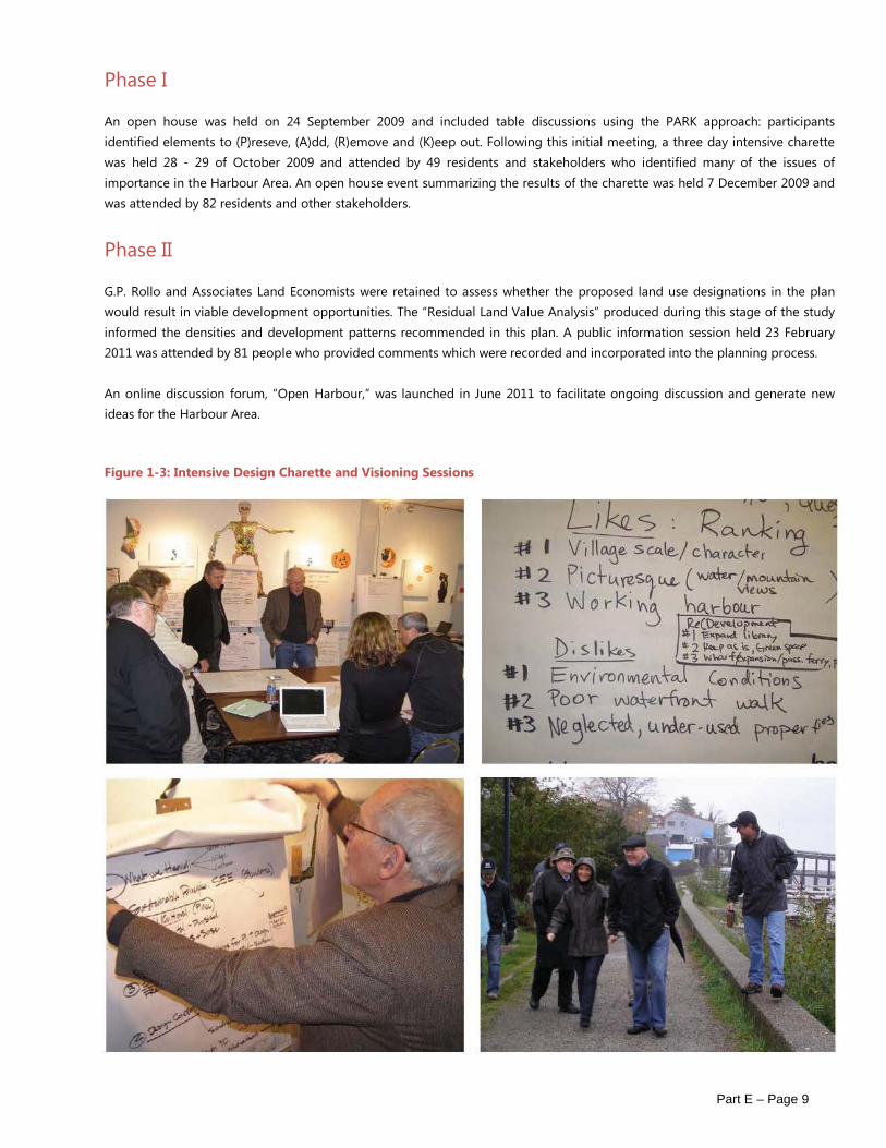
Phase I
An open house was held on 24 September 2009 and included table discussions using the PARK approach: participants identified elements to (P)reseve, (A)dd, (R)emove and (K)eep out. Following this initial meeting, a three day intensive charette was held 28 - 29 of October 2009 and attended by 49 residents and stakeholders who identified many of the issues of importance in the Harbour Area. An open house event summarizing the results of the charette was held 7 December 2009 and was attended by 82 residents and other stakeholders.
Phase II
G.P. Rollo and Associates Land Economists were retained to assess whether the proposed land use designations in the plan would result in viable development opportunities. The “Residual Land Value Analysis” produced during this stage of the study informed the densities and development patterns recommended in this plan. A public information session held 23 February 2011 was attended by 81 people who provided comments which were recorded and incorporated into the planning process.
An online discussion forum, “Open Harbour,” was launched in June 2011 to facilitate ongoing discussion and generate new ideas for the Harbour Area.
Figure 1-3: Intensive Design Charette and Visioning Sessions

Part E – Page 10
1.3 History of the Area
First Nations History
The landing area has always been a site of strategic importance. The Squamish First Nation (‘Sḵwxwú7mesh’ in the Squamish language) settled the area to the north of Gibsons Landing as a seasonal fishing village, Chek-welp. The Chek-welp villagers also used the Gibsons Landing area as a lookout for providing advance notice of invaders visible through the West Howe Sound gap. Outbreaks of small pox led to the eventual abandonment of the Chek-welp village in the early 1900s.
Pioneer Spirit: Early Settlers
While European explorers and fir traders visited the area in the 1800s, the first European settler to the Gibsons area, almost one hundred years after initial exploration, was George Gibson, an ex- British naval officer. In 1886 George Gibson built his homestead and began encouraging other settlers to come and live around him and form a community. Within two years, Gibson had built a two-storey house, planted 100 fruit trees and cultivated four acres of his land, enough to ship his produce to Vancouver to sell and enticed other early pre-emptors including the Soames, Winegarden and Glassford families.
A Working Harbour: Logging and Fishing Industries
The landing was dependent on water transportation and contact with the mainland was maintained by tugboats. In 1891 the Union Steamship Company began to call at the dock in Gibson’s Landing, making the area more accessible from the mainland.
The mainstay of employment for the early pioneers was related to logging and producing shakes or shingles. Fishing was another means of earning a living. Gillnetters were thick in the Rivers Inlet area, and almost every Vancouver fish company had a subsidiary camp in Gibsons Harbour. When fishing or logging was not productive, residents practiced subsistence agriculture to make ends meet. “Stump farming” as it was locally known, required the blasting out of tree stumps in order to create an appropriate landscape to farm.
As the population grew between 1910 and 1930, shops and services such as a bakery, a delivery service, a post office and drug store sprung up in the landing.
Logging with oxen on the Chek-welp Reserve between
Gibsons Landing and Granthams Landing
A view of the fishing fleet anchored in Gibsons harbor waiting for
the area opening. Taken from the Bluff looking across the
harbor to the wharf, circa 1930. A union steam- ship Co. vessel
approaches the wharf.

Part E – Page 11
Later Development
Until after World War II, Gibsons and area remained a small rural community based on logging, fishing and a limited amount of agriculture. Better roads and ferry connections spurred development in the 1950s: at this point, growth became much more rapid. Much of the more recent development in Gibsons has occurred in “Upper Gibsons”, where flat land allowed expansion and adequate parking compared to the old business area around the wharf at the waterfront. This trend in development continued, and today most commercial activity is located in Upper Gibsons while the waterfront has become increasingly oriented towards tourism and cultural activities.
The Gibsons Landing post office at the corner of School
Road and Gower Point Road, circa 1962, just before move to
new location at corner of Winn Road.
The businesses on the north side of Gower Point Road, just
west of the main intersection. The Heron Cafe, Florest and
Gifts, Gibsons Landing Professional Building, Hunter Gallery,
Granny’s sweets, N.D.P. Bookstore.

Part E – Page 12
1.4 Relationship to Smart Plan
Town of Gibsons’ Official Community Plan, “Smart Plan,” adopted in 2005 (updated 2014), includes a number of objectives and policies pertaining to the Gibsons Landing area. These objectives, in turn, were related to the Smart Plan’s Smart Growth framework, which seeks to address economic, social and environmental goals.
The Smart Plan recognized the unique function of the Gibsons Landing area and seeks to maintain the “small-town atmosphere,” while addressing the challenges of providing diverse housing and creating economic opportunities.
Policies presented in the Smart Plan, including the protection of the marine shoreline, creating new pedestrian and cycling linkages, protecting views, encouraging an active mix of uses, and enhancing streams and habitat, were incorporated into this Harbour Area Plan, which forms part of the Official Community Plan. The Harbour Area Plan refines and provides a greater level of detail to guide the development of the Harbour Area.
1.5 Relationship to Other Planning Processes
The Harbour Area has been the subject of a number of studies over the past few decades (see “Figure 1.4 Previous Studies of the Harbour Area” below).
A Revitalization Concept Plan was developed in 1995 by the Gibsons Landing Merchants Association in conjunction with the provincial Revitalization Program and the Town of Gibsons. This detailed plan provided guidance on design standards, parking, traffic circulation and other issues related to maintaining and developing the unique character of the Gibsons Landing area. In 2000/2001 a Harbour Master Plan was prepared, which proposed a direction for the future development of land and water uses. The Harbour Master Plan suggested more public land uses, and encouraged a floating market, restaurants/pubs and additional pleasure craft moorage.
This document draws on the context provided in these past studies and integrates with the recommendations in the following more recent plans, studies and reports pertaining to the Harbour Area:
o 2006 Gibsons Landing Parking Study o 2006 Mini-bus Shuttle Service Feasibility Study o 2010 Parks Master Plan (not yet formally adopted) o 2007 Coriolis Consulting Report: Approvals Process for Three Major Development Proposals in Gibsons
Figure 1-4: Previous Studies of the Harbour Area
1968 Gibsons Harbour Development Plan
1992 Official Community
Plan Includes section on the Harbour
1995 Gibsons Landing Downtown
Revitalization Study
2000 Gibsons – Naturally The Strategic
Plan
2000 Fresh Eyes on Gibsons
2001 Harbour Master Plan completed but not
adopted
2005 Smart Plan, Official Community Plan (adopted using parts of Harbour Master Plan)
2005 Harbour Authority holds a series of open houses and prepares a Harbour Plan Report

Part E – Page 13
2 THEMES AND VISION Throughout the public involvement process and study of the Harbour Area of the past several years, a number of common themes or issues have consistently arisen and are presented in Section 2.1 below.
2.1 Themes
Village Scale & Character
Embraced as a precious aspect of life in Gibsons, the Harbour Area has been variously described as “quaint”, “historic”, “small scale”, and “a quaint seaside village”. The area is characterized by its waterfront adjacency, harbour views, physical permeability (frequent spaces between and amongst built areas), visual permeability (the ability to see through to the water and other vistas), low building heights especially adjacent to pedestrian pathways, small scale commercial establishments, materials, architectural form, and the nature of the streetscape.
Accessible Waterfront
Along with Village scale and character, this issue consistently ranks as the highest area of concern for residents. The waterfront is both a community and public asset that forms a backdrop to life in the Harbour Area.
Environmental Sensitivity
Every community has a responsibility to foster environmentally sensitive and sustainable planning and development. Gibsons, and the Harbour Area in particular, is no exception. As a coastal community, the Harbour Area is custodian to the adjacent marine environment and the upland features that contribute to its wellbeing. In addition, the coastline will be particularly susceptible to the impact of climate change. Renowned for the quality of its water, the area’s aquifer is an important asset that requires special consideration.
Proximity to Nature
Many of the Town’s residents chose to live in Gibsons because of the Town’s and surrounding area’s spectacular natural beauty. The community is mindful of the need to protect these environmental assets.
Social Activity
Both residents and visitors to the Harbour Area enjoy a high degree of social activity supported by the “walkability” of the area and facilities such as the museum, library, waterfront walk, public wharf and parks.
Heritage / The Working Harbour
Some marine service activities and a significant remnant of the commercial fishing fleet remain in the Harbour. While these are unlikely to return to their prominent place in the economic life of the town, the working harbour remains as an important part of the community’s collective identity.
Part E – Page 14
Views
Views of the harbour and landforms beyond are key to the character of the Harbour Area. The topography of the area lends itself well to the capturing of these views from a variety of vantage points.
Economic Viability
The degree to which the social, cultural, and environmental goals of the community may be met through renewal and enhancement depends critically on the economic viability of development in the Harbour Area.

Part E – Page 15
Figure 2-1: Character Areas

Part E – Page 16
2.2 Character Areas
Based on current and potential land use, scale and character, the Harbour Area was divided into four Character Areas, as shown in the map in “Figure 2.1 Character Areas”. The darker coloured areas within each of these indicates locations that were specifically examined as key prototypes within each Character Area.
Cultural Precinct: Currently contains the Library, Museum and Archives and is earmarked in the plan for expansion and enhancement of cultural /institutional uses.
Village Landing: The commercial core and heart of the Harbour Area.
Legacy Residential: an array of varied housing types which has been developed organically over time, and offers potential for infill.
Village Waterfront: is an essential adjunct to the Landing, and contains major components of
public waterfront open space and marine activities

Part E – Page 17
2.3 Vision Statement
Facilitate balanced development that ensures the ongoing attractiveness and the social, cultural, economic and environmental vitality of the Harbour Area, recognizing the unique and crucial role it plays in the life and economy of Gibsons.

Part E – Page 18
3 EXISTING AND EMERGING CONDITIONS The following section provides a snapshot of relevant facts and trends impacting the Harbour Area, in the areas of land use, environment, economy, urban design, transportation and circulation, and infrastructure. Trends in the use of community facilities and demographic changes are covered in Part A of the Smart Plan OCP. These current conditions aid in the identification of opportunities and constraints which are responded to through the goals, objectives and policies outlined in this document.
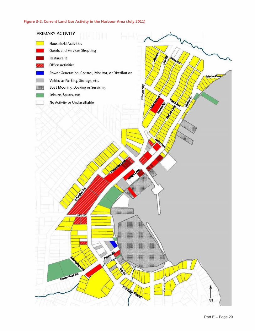
3.1 Land Use
The Harbour area is characterized by a mix of land uses and building types, including approximately 70 commercial establishments in 11,500 sq.m. of floor area1, 10 marine businesses, 107 Single Family residences, 93 Multi-Family residential units, eight parks, a range of civic and institutional uses including Town Hall, a Library, Museum, Post Office, Museum and Day Care, and approximately 17 undeveloped lots.
There are several heritage buildings located within the planning area, including the Inglis House, built in the first decades of the 20th century, which was central to both the early history of Gibsons and has national significance: at this location Inglis and Woodsworth discussed the ideas that resulted in the manifesto for the CCF party, which Woodsworth founded in 1932.
Land ownership is concentrated with several parties, with the Town of Gibsons owning and controlling significant holdings, including the Marina Lands, Holland Lands, Winegarden Park and a number of smaller parks in the area. The Gibsons Landing Harbour Authority manages and operates the Government Wharf. Directors of the Harbour Authority are appointed by the Town with a mandate to provide moorage and services to commercial fishing.
Though residential activities are predominant in the planning area (see “Figure 3.1 Current Activities in the Harbour Area, by Percentage of Land Area (2011)”), residential densities for the area are relatively low with approximately 200 residential units within the 57 acre planning area, neighbourhood density in the area is 3.5 units / acre. Neighbourhood densities of 4.5 are typical for mixed-use neighbourhoods and a typical single family neighbourhood has a density of up to 5 units per acre2.
The construction of the Wharfinger Building at the Government Wharf in 2000 and the redevelopment of Winegarden Park were the last significant land use changes in the area. A study conducted in 2011 by G.P. Rollo and Associates examined the economics of developing within the Landing Area and found that the land costs are too high and the densities permitted under the Smart Plan too low to attract development, particularly for townhouse sites.
5.75% of the land in the study area is bare (does not contain structures). Though no statistics are available on historical commercial vacancy rates and business turnover, the number of currently vacant shop fronts in the landing suggests that vacancy rates are high. While many of the commercial uses in the Landing area are oriented towards tourism, a survey of the Landing merchants conducted in 2011 suggests that many merchants’ businesses depend on support from the local market3. Vacancy rates could be partially attributable to the provision of an unsustainable amount of commercial gross leasable floor area relative to residential densities.
1 Gibsons Economic Development Partnership Report, 9 June 1999 2 Berke, Godschalk, et. al. Urban Land Use Planning, 2006 3 Best Coast Initiatives. Gibsons Landing Merchant Survey, April 2011

Part E – Page 19
Figure 3-1: Current Activities in the Harbour Area, by Percentage of Land Area (2011)
Marine Uses
The marine environment is an integral part of the Town of Gibsons municipal limits. The municipal boundary extends some 305 metres (1000 feet) seaward from the high tide mark. The Town of Gibsons has a Public Recreation Lease on the majority (not including Government Wharf) of the foreshore (101.7 ha) of Gibsons Harbour and a major portion of Shoal Channel granted in 1976. Within this overall lease, numerous sub-leases have been issued by the province for commercial marine uses.
Land along the Gibsons waterfront consists largely of residential use, except within the Gibsons Landing or harbour area. Gibsons Harbour is extensively developed inside the current breakwaters, with the two most prominent uses being the Government Wharf and Gibsons Marina. Other commercial uses include Smitty’s Marina, Hyak Marine, and a marine pub at the foot of School Road. The harbour has played an historic commercial role, providing a home port for the commercial fishing fleet, and as a marine service centre for businesses serving the nearby islands (Keats, Gambier and other coastal locations). The economic role of the harbour is covered in “3.3 Economy”.
Part E – Page 20
Figure 3-2: Current Land Use Activity in the Harbour Area (July 2011)

Part E – Page 21
3.2 Environment
Gibsons Landing is endowed with many natural assets. As a coastal community, the ocean and its aquatic life are defining natural features. Sedges, grasses, and shrubs are present along the waterfront and beach area. Distinctive hillside topography and vegetation surround the Landing area and define the character of the Town. A number of streams, including Goosebird Creek and Charman Creek, lead down through the Gibsons Landing area.
Water
Two principal water courses flow through the study area: Charman Creek and Goosebird Creek. Gibsons Creek is immediately north of the study area. A number of tributaries, ditches and other watercourses can be found throughout the low lying areas within the study area, some carrying water intermittently, or seasonally. Conditions along these creeks vary but both are heavily impacted by urbanization. Some areas along these streams have been remediated with secondary growth of riparian vegetation and a natural stream bed, whereas other parts are culverted or channelized without vegetation cover. Combined, these streams provide a drainage channel for overland flow for a large portion of Gibsons.
The Gibsons Aquifer extends beneath the Harbour Area, north to the base of Mt. Elphinstone and supplies excellent quality drinking water to two thirds of the Town’s residents. A thin layer of glacial till (Vashon Till) caps the aquifer in the Harbour Area, protecting the water supply from saltwater intrusion4. Protecting the Gibsons Aquifer from over use, contamination and salt-water intrusion are high priorities. Stormwater runoff, sewer outfalls, heavy use of the marine area by boaters, and low water exchange rates have raised concerns about the water quality in the Harbour. The Town is currently mapping the Gibsons Aquifer to identify its extent and monitor its capacity and recharge rates. The most significant discharge for the aquifer is the Harbour Area in the vicinity of Winegarden Park. A report on the condition of the Gibsons Aquifer indicates that the aquifer is very shallow in Gibsons Landing; caution should be taken when reviewing any development requiring pilings or significant excavation, both on land and within the
floor of the harbour itself.
Figure 3-3: Goosebird Creek
Brownfields/Contaminated Sites
In urban areas, soils and groundwater can become contaminated with various metals, hydrocarbons and other contaminants. Brownfields are sites of former commercial or industrial use which are underutilized and that may or may not be contaminated. The province has an incentive program for the use of brownfields, including guidance for municipalities5. The assessment and cleanup of these areas is governed by the BC Waste Management Act, Contaminated Soils Regulation. The onus is on proponents for any new development or property transfers to retain an environmental consultant to assess and plan remediation for a site.
Habitat 4 Interim Report, Aquifer Mapping Study, Town of Gibsons, Waterline Resources, June 2010 5 www.brownfieldrenewal.gov.bc.ca
Part E – Page 22
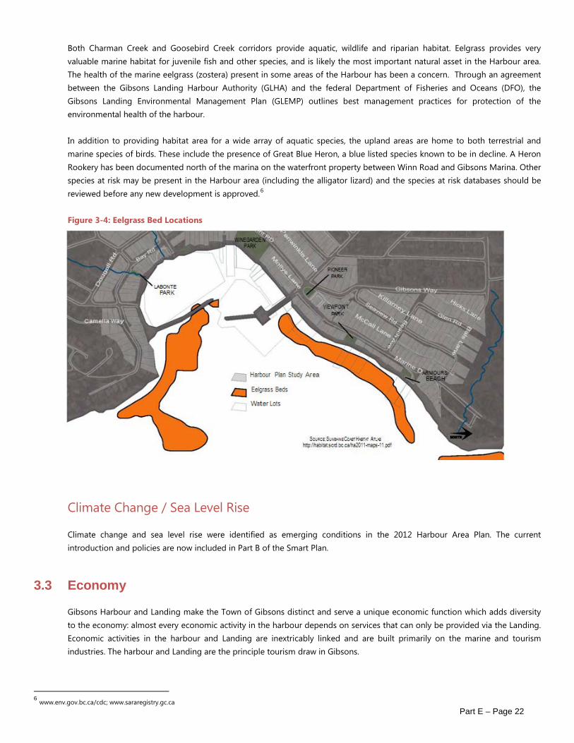
Both Charman Creek and Goosebird Creek corridors provide aquatic, wildlife and riparian habitat. Eelgrass provides very valuable marine habitat for juvenile fish and other species, and is likely the most important natural asset in the Harbour area. The health of the marine eelgrass (zostera) present in some areas of the Harbour has been a concern. Through an agreement between the Gibsons Landing Harbour Authority (GLHA) and the federal Department of Fisheries and Oceans (DFO), the Gibsons Landing Environmental Management Plan (GLEMP) outlines best management practices for protection of the environmental health of the harbour.
In addition to providing habitat area for a wide array of aquatic species, the upland areas are home to both terrestrial and marine species of birds. These include the presence of Great Blue Heron, a blue listed species known to be in decline. A Heron Rookery has been documented north of the marina on the waterfront property between Winn Road and Gibsons Marina. Other species at risk may be present in the Harbour area (including the alligator lizard) and the species at risk databases should be reviewed before any new development is approved.6
Figure 3-4: Eelgrass Bed Locations
Climate Change / Sea Level Rise
Climate change and sea level rise were identified as emerging conditions in the 2012 Harbour Area Plan. The current introduction and policies are now included in Part B of the Smart Plan.
3.3 Economy
Gibsons Harbour and Landing make the Town of Gibsons distinct and serve a unique economic function which adds diversity to the economy: almost every economic activity in the harbour depends on services that can only be provided via the Landing. Economic activities in the harbour and Landing are inextricably linked and are built primarily on the marine and tourism industries. The harbour and Landing are the principle tourism draw in Gibsons.
6 www.env.gov.bc.ca/cdc; www.sararegistry.gc.ca

Part E – Page 23
Economic Activities in the Landing
A 2010 survey revealed that tourism contributes 30% of store revenues, with nearly half of stores reporting 50% or more of their revenue drawn from tourism related activities. Comparatively, stores in Upper Gibsons report tourism spending represents 10% of revenues, with no stores reporting more than 25%.
The Landing is the location where most of Gibsons’ major events are held. These events are sources of revenue for Landing merchants and the organizations that organize the events.
Nonetheless, tourism to the Landing is underexploited. The harbour and Landing are picturesque and unique, but the assemblage of shopping and activities is insufficient to attract and retain visitors. Marine and motor tourism meet at the Landing. Growth in either affects the other and both contribute to congestion in the harbour and the Landing.
In addition to tourism activity, the Landing houses an array of services to residents of Gibsons and the Sunshine Coast and businesses in the Landing depend on local shopping for 70% of their revenues. Most of the Landing’s stores are family run businesses, which has social and economic benefits. Few merchants own their building, but more than half of the retail space is locally owned. This pattern of resident shopkeepers and resident building owners makes the Landing a cornerstone of the local economy.
The Landing is also a centre for professional services including accounting, law, real estate sales and a variety of consulting and information technology firms.
Economic Activities in the Harbour: Moorage There are approximately 360 resident (local) and 100 non-resident pleasure craft moored in the harbour year round. Annual revenue from permanent pleasure craft moorage is approximately $570,000 per year, and moorage fees and purchases made by vessel owners are new dollars brought into the local economy.
The Small Craft Harbour and Gibsons Marina berth transient vessels visiting over-night and for stop-overs. Transient vessel owners are an important source of tourism spending, adding approximately $800,000 to the Landing economy annually. There are not enough berths in the harbour to accommodate the marine tourism market and a significant amount of revenue is lost to the local economy as a result.
Approximately 20 fishing vessels moor in the Small Craft Harbour. Other commercial craft moored in the harbour include water taxis, tour boats and rental and training craft. These vessels take up little space, but they are active.
Demand for berths far exceeds the harbour’s capacity. The Gibsons Landing Harbour Authority (GLHA) has a plan to expand by 100 berths, but lacks the capital to construct. Other locations for expansion have been suggested, but all are more capital intensive than expanding the Small Craft Harbour. Currently, the likelihood of obtaining the necessary funds is low and expanded moorage at other proposed locations would require very high private sector investment and extensions of the shoreline or new roads and does not seem a likely scenario. Adding 100 berths would provide additional funds for the operational and maintenance of the Small Craft Harbour. Expansion would also have implications in terms of vehicle traffic and parking.
Economic Activities in the Harbour: Commercial Fishing The commercial fishing fleet employs approximately 60 persons seasonally and spends an estimated $500,000 annually on marine services. The fishing fleet has shrunk over the past decades and expansion seems unlikely.

Part E – Page 24
Economic Activities in the Harbour: Marine Services There are limited marine services supplied in the harbour and therefore revenue from regular vessel maintenance is largely lost to the local economy, because the harbour does not have a marine services facility with a haul-out capability. Resident craft typically travel long distances for their routine maintenance needs. A conservative estimate of annual lost spending on maintenance for all permanent pleasure craft is $500,000.
In 2010, Best Coast Initiatives (BCI) surveyed 28 Small Craft Harbours and private marinas in order to assess the demand and supply of vessel berths and routine vessel maintenance services in the Georgia Strait region. The analysis determined that there is a shortage of both. Thousands of vessels do not have berths. Vessels travel long distances to obtain services and waiting times for services are getting longer. The existing marine services industry serving Gibsons Harbour will remain vigorous and would expand if harbour capacity is increased.
Currently, there are no marine congestion issues and future marine congestion is unlikely, even with the expansion of the small craft harbour.
Economic Activities in the Harbour: Commercial Services Commercial services contribute to a working harbour, to tourism appeal and are high value additions to the economy. Existing services include water taxis, tours, sail and motor boat rentals and training, cargo transport, fuel sales and retail sales. We include sailing clubs and paddling clubs in commercial operations because they have economic benefits.
The Small Craft Harbour is a hub of commercial services and a logical place for additional services, especially those used by tourists. Consideration should be given to the impact on the fishing fleet of busy tourism activity. Gibsons Marina is the preferred location for sailing and paddling clubs and the likely place for their expansion. Armours Beach has potential to become more active as a club and training facility.
The sole fuel facility in the harbour is at Hyak Marine. Across the Georgia Strait region, marine fuelling facilities are becoming fewer, which could mean more activity at the Hyak depot and increased activity in Gibsons Harbour.
Economic Activities in the Harbour: Marine Transport Cargo transport is an essential service of the Small Craft Harbour and the Small Craft Harbour is a primary cargo transfer facility for residents of Keats and Gambier Islands. The only boat launch facility is located at Gibsons Marina. Some barge cargo is unloaded at that location.
Economic Activities in the Harbour: Marine Tourism The potential for growth in marine tourism is great. Powell River Economic Development estimates that 16,000 pleasure craft tour the Sunshine Coast each season. Currently, the total capacity of Gibsons Harbour is limited to about 25 and vessels are occasionally turned away.
This influx of spending is what is needed to support commercial development at the harbour landing interface. It gives rationale to improving amenities such as the seawall walk and avenues between the seawall and the streets above. Marine tourism does not generate a need for parking space. Marine tourism may be hampered in the future by large increases in the cost of diesel fuel; however, rising fuel costs might increase regional, short cruises, which would somewhat compensate for an overall decline. Cautious assessment of the future market for transient pleasure craft moorage should be made prior to investment in expanded facilities. In the short term, establishing mooring buoys has a low capital cost that is recoverable from moorage fees and would provide new facilities for visiting boaters.

Part E – Page 25
New Commercial and Residential Investment in new commercial space depends on an increased customer base via higher tourism volumes, increased population in the Harbour Area and increased Sunshine Coast resident shopping. Increased marine and motor tourism will be important drivers of commercial expansion and viability. An additional source of commercial occupancy that is not dependent on those factors is professional services.
3.4 Circulation
Transportation to, from and within the Gibsons Landing area is heavily reliant on the private automobile, with some degree of traffic congestion occurring near the commercial node along Marine Drive throughout the summer peak season. Vehicle traffic in the Landing, and the lack of viable transportation alternatives, have led to a number of concerns including the availability and adequacy of parking and pedestrian safety.
Parking
Historical development of the area prior to the introduction of the automobile or bylaw regulations has resulted in many existing uses that have no parking at all. Despite this, a 2007 study indicates that there is adequate parking capacity within the Landing Area in 236 on-street spaces and 80 spaces in public parking lots. The 2007 study raised several on-going parking issues: road blockages due to loading activity; low parking fines that do not act as deterrents and inadequate signage have all combined to result in a parking management issue7.
Bicycle Facilities
The bicycle network within the Landing Area is poorly developed: there are currently no designated bicycle routes, signage, lanes, or other facilities. The lack of bike racks, lockers, and signage are identified in Gibsons Landing Parking Study, 2007.
Significant road improvements have been designed for Gower Point Road from Winn Road, east to Prowse Road. These improvements will provide grade separated bicycle lanes and a sidewalk separated from the cycle lane by boulevard wherever possible. Narrow vehicle lanes will provide physical incentive for slower traffic speeds. The completion of this improvement will introduce the first segment of cycling infrastructure, in the form of a grade separated bicycle way that will form a piece of an eventual continuous coastal route from Langdale through to Elphinstone and beyond.
Transit
Gibsons Landing is currently served by BC Transit. 48 buses per day are routed through the area and take passengers to Langdale or Sechelt. A 2007 study found that 26% of trips originating in Gibsons Landing are destined for Upper Gibsons8. An implementation study has indicated that a Community Shuttle, linking Gibsons Landing and Upper Gibsons, could recover operating costs through fare revenues. A Transportation Survey Report completed in 2007 indicated that 51% of Gibsons respondents would be interested in a car share arrangement9.
Pedestrian Circulation
The combined activity from residents living in the Landing, tourists, and vehicle traffic has created pedestrian conflicts and safety issues in the Landing. A 1995 Study called the Gower Point Road/Marine Drive intersection (‘Five Corners’) “a dangerous
7 Gibsons Landing Parking Study, 2007 8 Gibsons Transit Feasibility Study, 2007 9 Corbett, D. Sunshine Coast Transportation Survey. April 2007
Part E – Page 26
situation, especially for pedestrians.”
A continuous sea walk along the water’s edge between Armours Beach Park to the north and the proposed Breakwater Park to the south has been developed in segments over time and the Town has made a policy of acquiring this right-of-way for pedestrian access as development applications come forward.
3.5 Infrastructure
Some of the critical infrastructure in the Harbour Area is nearing its replacement age. The Prowse Road Pump Station, which lifts sewage up to the Sewage Treatment Plant on Stewart Road, has reached its safe capacity and is at the end of its life expectancy. The station will need to be completely rebuilt and upsized; funding opportunities for this work are being actively investigated. The shoreline trunk sewer, a main sewer line that runs parallel to the shoreline in Gibsons Landing requires a detailed assessment to determine its condition.
Safety improvements are proposed at Five Corners, including the possible closure or restriction of turning movements at the School Road leg. In addition, it is planned to convert the existing 3-way stop for the main intersection into a more traditional 4-way stop. Narrowing of Marine Drive is proposed at the existing crosswalk at Pioneer Park.
Marine Drive within Gibsons is proposed to have a reduced speed limit of 30km/h, and this lower speed limit has also been contemplated for all of Gibsons Landing. The Sunshine Coast Regional Transportation Plan is proposing to downgrade Marine Drive from the BC Ferry Terminal to Gibsons from arterial to collector status while supporting improvements that emphasize pedestrian and cyclist use.
An upgraded storm drainage system down School Road is planned with the outfall to be constructed under the Molly’s Lane stairs which are budgeted for replacement in 2011.
Various watermains will require upgrading or replacement in Gibsons Landing. The Town conducts an annual replacement program for its aging watermains in both Upper Gibsons and Gibsons Landing and will upsize identified mains where the opportunity exists. Development may also trigger upgrades in order to provide adequate water for fire and domestic supply.
3.6 Urban Design
There are many definitions of “urban design”. Most of them are similar to the following, from the Planning Department of the City of Auckland, New Zealand:
“Urban design is the multi-disciplinary skill of designing and arranging all the physical elements that make up cities to create harmonious, vibrant and successful places for people.”
Built Form
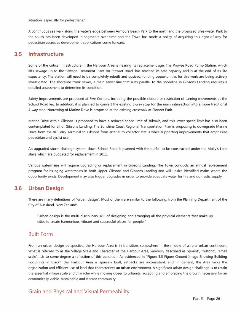
From an urban design perspective, the Harbour Area is in transition, somewhere in the middle of a rural urban continuum. What is referred to as the Village Scale and Character of the Harbour Area, variously described as “quaint”, “historic”, “small scale”, …is to some degree a reflection of this condition. As evidenced in “Figure 3.5 Figure Ground Image Showing Building Footprints in Black”, the Harbour Area is sparsely built, setbacks are inconsistent, and, in general, the Area lacks the organization and efficient use of land that characterizes an urban environment. A significant urban design challenge is to retain the essential village scale and character while moving closer to urbanity, accepting and embracing the growth necessary for an economically viable, sustainable and vibrant community.
Grain and Physical and Visual Permeability

Part E – Page 27
A fine-grained urban environment is one that is both physically and visually permeable. It implies a rich network of opportunities for pedestrian movement and many opportunities for views or glimpses through and between buildings. The Harbour Area appears to have such a grain. In fact, this grain and permeability is a function of a “pre-urban” condition, and is mostly visual since real opportunities for enhanced physical permeability are limited by ownership patterns. It is possible to retain and enhance the characteristics of fine grain in a more urban, or village, setting and this is another facet of the urban design challenge.
Scale
While to some degree the scale of the Area is a function of its “pre-urban” grain, other factors contribute to scale:
o building heights are low – mostly one and two storeys with some fairly recent exceptions at the four storey wood frame maximum10;
o site coverage is low; o retail frontages are small; o street level transparency in the commercial part of the Area is good.
Siting (Orientation, Axis, Landmarks)
The topography of the area supports building orientation that allows for good sunlight exposure and capturing of distant views (often of the harbour and land forms beyond). The street pattern, in response to topography and shoreline offers opportunities to create visual foci, or special architectural events at the ends of visual axes to create landmarks for physical and visual orientation and enhanced visual interest.
Materials, Massing, Colour, Architectural Form
The great variety of materials, massing, colour and architectural style in the Area provides variety on one level, but lacks a coherence that could enhance the Area’s brand.
Since adoption of guidelines in the 2005 Smart Plan, recent development – e.g. Gower Gardens, or The Landing, have begun to provide that coherence.
Streetscape (Street Furniture, Street Lighting, Paving, Scale, Planting)
In the Village Landing, as a result of past Downtown Revitalization projects the streetscape is of a reasonably high quality. Elsewhere in the Harbour Area, streetscape enhancements are needed. The scale of the road that results from angled or perpendicular parking is inefficient and detracts from the desired small scale village character.
10 Until recently the maximum height for wood frame buildings under the Provincial Building Code, was four storeys. The maximum has been increased to six storeys.

Part E – Page 28
Part E – Page 29
Figure 3-5: Figure Ground Image Showing Building Footprints in Black

Part E – Page 30
4 GOALS AND OBJECTIVES Major themes discussed in Section 2 of the Harbour Area Plan and in the existing and emerging conditions in the Harbour Area (Section 3), give rise to a corresponding set of goals for planning and development of the Harbour Area which respond to these challenges. The five goals below follow the principles outlined in the 2005 Smart Plan, which seek to created balanced development which furthers the social, cultural, economic and environmental aspects of sustainability.
GOAL 1 RETAIN THE SCALE AND CHARACTER OF THE HARBOUR AREA Objective 1.1 Ensure new development is compatible in scale with existing development in the Harbour Area.
Objective 1.2 Ensure new development evokes a west-coast, seaside village feel.
Objective 1.3 Maintain a pedestrian focus through street-oriented buildings developed to a high quality design standard.
GOAL 2 MAKE THE WATERFRONT FULLY ACCESSIBLE, PHYSICALLY AND VISUALLY, RETAINING THE SENSE OF PROXIMITY TO NATURE Objective 2.1 Complete and enhance the Town’s pedestrian and cycling network, creating a bicycle and pedestrian friendly
Harbour Area.
Objective 2.2 Ensure that the waterfront is physically and continuously accessible to the public along its entire length.
Objective 2.3 Upgrade and improve the existing park system and waterfront walkway.
Objective 2.4 Create and protect public and private views through to the water.
GOAL 3 ENSURE ENVIRONMENTALLY RESPONSIBLE AND SUSTAINABLE PLANNING AND DEVELOPMENT Objective 3.1 Protect the Gibsons Aquifer and water quality in the Harbour Area.
Objective 3.2 Implement climate adaptation strategies which account for the short and long term effects of climate change.
Objective 3.3 Support ecologically sensitive development, adding an environmental restoration and enhancement
component to new development, where appropriate.
Objective 3.4 Take a “no-net-loss” or “net gain” approach to existing habitat and ecological function.
Objective 3.5 Assess the impacts to water quality of all new development.

Part E – Page 31
GOAL 4 SUPPORT AND ENHANCE SOCIAL AND CULTURAL ACTIVITY IN THE HARBOUR AREA Objective 4.1 Plan for a mix of housing types to accommodate social diversity in the Harbour Area.
Objective 4.2 Upgrade and add to existing cultural facilities (library, museum, etc.) in the Harbour Area and encourage an
increase in the number of amenities and sites of interest.
Objective 4.3 Improve connections to and from the Harbour Area, particularly connections via transit and other alternative
transportation options.
Objective 4.4 Design for a range of ages, creating accommodating, accessible and desirable spaces for children, families, and
seniors.
GOAL 5 ENSURE THE ECONOMIC VIABILITY OF THE HARBOUR AREA, RECOGNIZING THE UNIQUE ROLE THE HARBOUR PLAYS IN THE LOCAL ECONOMY AND THE ECONOMIC HISTORY OF THE AREA Objective 5.1 Plan for increased parking and traffic and allow for an acceptable impact from these activities.
Objective 5.2 Facilitate growth to accommodate additional population in the Harbour Area.
Objective 5.3 Expand the capacity of the marine harbour for transient boaters, resident boaters, and commercial vessels.
Objective 5.4 Support the development of tourist accommodation and meeting facilities in the Harbour Area.
Objective 5.5 Support increased, year-round commercial and tourist activity in the Harbour Area.
Objective 5.6 Retain and enhance working harbour activities and maintain a diversity of commercial activity in the Harbour
Area, while taking steps to mitigate possible impacts on the natural environment and residential areas.
Objective 5.7 Maintain and improve existing infrastructure, expanding its capacity to accommodate growth.

Part E – Page 32
5 PLAN POLICIES The goals and objectives outlined in the previous Chapter will be implemented incrementally through both public and private actions guided by the policies presented below. These policies include land use designations controlling density and the locations where specific uses will be permitted, the desired character of new development, environmental policies, and policies to guide future investment in transportation and infrastructure. Other policies concerning more general areas of concern are outlined in the 2005 Smart Plan.
5.1 Land Use Plan
The original 2012 neighbourhood land use plan is shown in “Figure 5.2 Harbour Area Neighbourhood Design Concept”. Since then, Land Use Designations for this area have been merged and consolidated with the land use designations of the Smart Plan (Part B, Section 5).
Figure 5-1: Harbour Area Land Use Plan by Total Area and Percentage

Part E – Page 33
Figure 5-2: Harbour Area Neighbourhood Design Concept
Part E – Page 34
Build out
The proposed land use frame work results in more than 900 residential units within the Harbour Area study boundaries at full buildout, assuming average unit sizes of 140 sq. m. for units in multiple unit development (shown in “Figure 5.4 Potential Future Development of the Harbour Area” below). This represents a possible 700 unit increase over existing development in 2011 and a net increase of 135 units over the build-out anticipated under the land use regulations for the area depicted in the 2005 Smart Plan.
Commercial Harbour
Within the Commercial Harbour designation a wide range of marine uses are supported. These include both visitor oriented activities such as marinas and associated upland uses, boat sales, charters and marine fuel sales, as well as marine industrial/transportation uses such as public boat moorage, commercial fishing moorage, boat building and repairs, marine ways, water taxis, float plane docks and tug/barge operations. Due to the nature of marine activities, some noise and visual impacts will be an inevitable part of the Commercial Harbour uses. The Marine Recreation designation encompasses the shoreline area north of the government dock and out to the harbour entrance light. This area is considered to be a secondary marine use area where limited or seasonal marine uses may take place in the future. Due to the more shallow water depths, lack of sufficient upland for parking or buildings and impacts on adjacent residential uses, this area is not considered suitable for general commercial marine use. The Commercial Harbour includes the water area between the break- waters where most commercial marine activities now take place.
Form and Character
“Maintaining a “village scale and character” for the Harbour Area is clearly of importance to Gibsons residents. A “village” is usually characterized by pedestrian-orientated development, which in turn encourages walking and cycling as well as social interaction. “Village scale” generally refers to smaller built forms that are low rise in nature, usually up to 3 or 4 storeys. Additional storeys or partial storeys may fit with the idea of “village Scale” if stepped back sufficiently or terraced, and integrated into the topography and roof forms of the building and with minimum impacts on public and private views.
“Village character” refers to built form that is pedestrian-friendly as well as human in scale. This includes closely spaced buildings located at or near sidewalks and paths, with active uses at grade and building forms that are compatible with existing and future nearby structures.
Policies
o Rezoning applications must be consistent with the land uses and densities indicated in Part B of the Smart Plan OCP. o In order to maintain a village scale & character in Gibsons Harbour area, building heights should generally be limited
to 1 or 2 storeys on the higher side of the lot and 3 to 4 storeys as seen from the lower side of the lot depending on the degree of slope. Exceptions to this general guideline may be considered through an OCP amendment on a case by case basis.
o The form and character of development in the Harbour Area is subject to the guidelines of Development Permit Area 5.
o Development proposals requiring rezoning shall be required to comply with the Town’s Affordable Housing and Community Amenity Policy and the Town will negotiate specific community amenities that developers will be required to provide to the Town on a case by case basis in accordance with the terms of the Affordable Housing and Community Amenity Policy.
o Acquire and secure land in public ownership for a waterfront linear park between Winegarden Park and the Marina Lands, in the location generally indicated on the Land Use Plan Map.
o Land required for public access to the water will be acquired as redevelopment occurs.
Part E – Page 35
o Support the long-term development of the northern portion of the Holland Lands (where the school district building is currently located), for a range of commercial and residential uses.
o Support a mix of uses along and on the water’s edge including a fish market, restaurants, and floating markets, along with ‘working harbour’ uses and marine businesses.
o Limit the extent of retail and service commercial development in Gibsons Landing to Gower Point Road and Marine Drive, designated as ‘Mixed-Use Residential / Commercial’ on the Land Use Plan to ensure pedestrian accessibility and enjoyment and to create a concentrated shopping core.
o Support an integrated mix of commercial and multi-family housing in the Mixed Use – Residential/ Commercial designation, in accordance with the following provisions:
a. other than as may be required for access and / or egress for the residential component of any building, ground floor use is to be exclusively commercial;
b. multi-family housing may consist of apartments or townhomes integrated with the commercial use, and may be located above or below the commercial use depending on the site location;
c. no overall density for mixed commercial and residential use is established due to the diversity of lot sizes and situations. However, it should be noted that many smaller properties will require consolidation in order to meet bylaw standards for parking, access, etc.
o Provide for a combination of housing units, including single-family and two-family homes, townhouses, and apartments in the Gibsons Landing area to support a viable and lively village heart and to accommodate the needs of different age groups.
o Encourage densification through infill development in the areas designated as Low Density infill through further exploration of appropriate mechanisms for introducing accessory dwelling units (carriage/coach housing) which are compatible in scale, form and character with surrounding development.
o In conjunction with a larger harbour, consider allowing the use of float homes and other live aboard vessels for permanent residences in the harbour area. This is subject to appropriate regulations to prevent adverse environmental impacts which may include the use of holding tanks and pump out stations. This may also require a study to understand the impacts, and amendments to the Zoning Bylaw.
o Development will respect Crime Prevention Through Environmental Design Principles (CPTED), by clearly delineating public and private space, maximizing ability to view public spaces, and providing appropriate lighting.
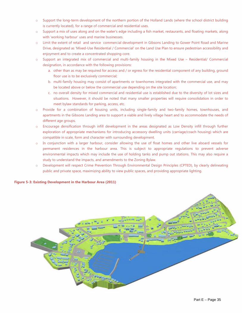
Figure 5-3: Existing Development in the Harbour Area (2011)

Part E – Page 36
Figure 5-4: Potential Future Development of the Harbour Area

Part E – Page 37
Figure 5-5: Illustration of Potential Village Landing Development
5.2 Environmental Building
Many Gibsons residents were early adopters of environmentally responsible design, installing solar panels, solar hot water collectors, rain barrels and other low impact technologies many years before these technologies entered into the mainstream. It was not surprising, then, that a host of environmental issues came to the forefront in the community discussions that led to the creation of this plan. The policies outlined below are intended to ensure that Gibsons’ future built environment keeps with this spirit of innovation and continues to demonstrate leadership in environmental design, building technologies, energy conservation and energy production.
Policies
o All new development (rezoning or development permit applications) should be required to demonstrate a sustainable or low impact development approach, using one of several existing systems, such as but not limited to LEEDTM and Built GreenTM. The main categories for consideration include: sustainable sites, water efficiency, energy efficiency, reuse and recycling of materials and resources, indoor air quality, certification is not required, but documentation of “equivalency” will be expected to accompany all submissions.
o Develop a sustainability checklist specific to the Harbour Area.

Part E – Page 38
o Renewable energy production should be explored in all major new developments in the Harbour Area, including district energy systems using ground or ocean sourced geo-exchange heating and cooling, tidal energy, wind energy, solar energy or other low carbon energy production.
o Encourage the development of car co-ops, supporting reductions in parking requirements where shared vehicles are provided.
o Promote the cleanup and redevelopment of brownfield sites within the Harbour Area and pursue grants and funding for this purpose, including provincial assistance available through the Provincial Brownfield Redevelopment Strategy (2008).
o Stormwater management and sediment and erosion control plans will be provided with all new developments, and will incorporate site planning measures or technologies to control surface run-off.
o For sites within the aquifer area, require development proponents to engage a hydrogeologist to prepare and substantiate strategies for the aquifer protection throughout all stages of development.
Figure 5-6: Environmental Best Management Practices, Such as on-site Stormwater Retention and Bio-filtration

Part E – Page 39
5.3 Natural Environment
There are four main elements needed to achieve the overall goal of environmental protection of the natural assets of the Harbour area: identification, assessment, approvals guidance and mitigation/enhancement options.
Identification
A study by Thurber Engineering (1991) of the entire Town identified environmentally sensitive areas, which were then assigned a Development Permit Area or Greenbelt designation. A detailed inventory of environmentally sensitive areas in the Harbour area should be maintained by the Town and updated regularly. There are several provincial databases that can be used as the basis for this inventory, but a finer detail of mapping is required to protect smaller natural elements, as are typically found in an urban area. By maintaining a publicly available inventory, decisions can be made both by private individuals and Town representatives that routinely consider the environment when making decisions. Environmental information provided by development applications can be used to update the Harbour Area inventory. As is contemplated in the Smart Plan (2005), a tree inventory and tree protection by- law can be used to complement the environmental inventory. Any routine monitoring (i.e. water quality) should be added to the inventory, as it provides a valuable baseline for assessing impacts of proposed actions. The province maintains a registry of sites with contamination, and remediation of them as the opportunities arise will lead to gradual improvement of soil and groundwater quality.
Assessment
To achieve the greatest protection of the environment, all decisions, whether new development or ongoing maintenance and operations, public or private, should be required to assess the potential impact of their proposed actions. There are prescriptive methods for assessment of some elements (i.e. the Riparian Area Regulations for stream setbacks), but the general method of impact assessment should be required for all actions. By requiring some identification of potential impacts, the onus is on the proponent to propose measures for avoidance or mitigation of impacts.
Figure 5-7: Naturalization of Watercourses (Charman Creek)

Part E – Page 40
Potential developers are directed to consult guidance documents which describe best management practices and techniques for avoidance and mitigation, including:
o Develop with care: Environmental Guidelines for Urban and Rural Land Development in BC; o Best management Practices for Amphibians and Reptiles in Urban and Rural Environments in BC; o Riparian Areas Regulation Assessment Methods; Stream Stewardship: A Guide for Planners and Developers; o Access Near Aquatic Areas: A Guide to Sensitive Planning, Design and Management.
Approvals
The Town’s main tools for environmental protection include the designated Environmental Development Permit Areas and existing Tree Protection Bylaw.
Mitigation/Enhancement
Many of the guidance documents listed above provide best management practices and mitigation measures. The Town could develop and maintain a list of standard best management practices that are required with all developments (ie-oil/water separators for all parking areas). While the onus should be on the proponent of a given project to propose an appropriate mitigation, then Town could be proactive and maintain a list of potential enhancement projects. Local environmental and stream keeper groups typically have suggestions for potential projects.
Policies
o The Town will maintain a publicly accessible and periodically updated inventory of sensitive environmental features identified in the Harbour Area.
o Require environmental impact studies in all rezonings in the Harbour Area. o Maintain and enhance the natural shoreline and aquatic zone through planting, by avoiding ‘hard’ infrastructure in
the foreshore, and by creating wetlands and marsh areas for habitat and to protect shorelines against erosion from currents, fetches and wakes.
o Formulate and implement a revegetation and enhancement plan for streams within the Harbour Area including streambank stabilization to reduce erosion and sediment flow to the harbour, daylighting culverted streams, removing obstructions, and creating new habitat and spawning areas.
o Protect existing natural assets and habitat areas such as the known Heron Rookery north of the Marina Lands, and the eelgrass (zostera) areas which function as nursery grounds for many species.
o Clearly mark eel grass areas with physical signage, maps in locations along the Harbour walk, and by providing downloadable documents and GPS coordinates.
o Explore measures to improve the quality of water in the Harbour (such as increasing tidal flushing by opening booms at Armours Beach in the winter, monitoring live-aboards to ensure they are self- contained, and improving spill control response at all marina sites).
o Install Oil-Water Separators, for the removal of floatable petroleum based contaminants from small areas of concentrated activity (e.g. gas stations and parking lots).
o Increase environmental education and signage focused on the foreshore area, including installing yellow fish markers on curbside storm drains, which indicate that drains empty into nearby creeks and foreshore areas that likely contain fish habitat.

Part E – Page 41
Figure 5-8: Eelgrass (source Mayne Island Conservancy Society) Figure 5-9: Concept Sketch of Waterfront Walkway (View Towards Hyak Marine Site)

Part E – Page 42
5.4 Pedestrian and Bicycle Circulation
Bike routes should not require cyclists to make detours which add significantly to the distance or difficulty of getting from A to B. In the Gibsons Landing context, bicycle routes that require avoidable hill climbing will not be used. It is therefore recommended that Marine Drive / Molly’s Lane/ Winegarden / Linear Park along Hyak be designated as a bike route. Desired future bicycle and pedestrian routes are shown on “Figure 5.10 Pedestrian Circulation Plan” and on “Figure 5.11 Bicycle Circulation Plan”. Town-wide bicycle routes are shown on the “Bicycle and Trails Master Plan” included elsewhere in the Official Community Plan.
Pedestrian Circulation Policies
o Through the development process, acquire pedestrian routes as Town Right-of-Ways as shown on the Pedestrian Circulation Plan Map.
o For pedestrians, provide an extensive pedestrian pathway system designed to filter throughout the Landing area. This will provide options for pedestrian movement both across the length of the Landing area and from the upper residential areas down to the waterfront – creating linkages to civic and park spaces and related developments, such as the proposed cultural precinct on Holland Lands.
o Future improvements to all roads shall be designed to accommodate a range of transportation modes, prioritizing travel on foot, bicycles, scooters and transit vehicles, while allowing for automobile circulation.
o Provide a continuous disabled-friendly footpath following the shoreline from the south-eastern breakwater (Breakwater Park) in the south to Armour’s Swimming Beach in the north. Use a variety of treatments along the Harbour front walkway to create a natural feel and extend the walkway onto elevated boardwalks, where feasible.
Figure 5-10: Pedestrian Circulation Plan

Part E – Page 43
o Provide sidewalks on both sides of Gower Point Road / Marine Drive from Dougall Road in the south to Town’s boundary in the north. From Dougall Road to Jacks Lane, where possible these should be at least two metres wide. Varying cross-section width, with setbacks alongside newer buildings could provide variety and interest.
o Provide sidewalks on both sides of South Fletcher Road (School Road to Winn Road). o Improve accessibility by providing disabled-friendly ramps at key intersections and trails, including “five corners”. o Provide lane access midway between School Road and Winn Road from Winegarden Park and Gower Point Road
(Harbour Steps) to link with the walking path leading up to Upper Gibsons (on the 500 block of South Fletcher). o At key intersections and mid block where pedestrian routes cross arterials/collectors, consider terminating parking
lane and providing corner bulges or roadway narrowing for clearly visible, raised or textured, pedestrian crossings. o To ensure continuous public access to the waterfront, no new licenses for private wharfs will be issued between
Gibsons Marina and the southern boundary of the Town and between Gramma’s Pub and the northern boundary of the Town.
o Site development should create and enhance public pedestrian linkages between major roads and the shoreline; and both the shoreline edge and the streetscape along Gower Point Road/Marine Drive should be considered as the focal points of any development.
o Create a series of ‘nodes’ focused on water uses that add interest and variety to the waterfront. These ‘nodes’ include: a. Armour’s Swimming Beach; b. Future moorage and potential marina for transient boaters; c. Government Wharf with existing community facilities as well as the terminus of the future public transit
linkage from Gibsons Landing to Upper Gibsons; d. floating markets (including day moorage slips in a central harbour location); e. floating maritime museum and restaurant; f. Hyak Marine; g. Marina; and

Part E – Page 44
h. extended harbour-front walkway to southern breakwater and gazebo. o Create a pedestrian, market plaza at the foot of School Road, which could also incorporate parking. o Enhance connections from the Landing to provide safe routes to schools.
Bicycle Circulation Policies
o Through the development process, acquire bicycle routes as shown on the Bicycle Circulation Plan Map. o Actively support the development of a safe, continuous bicycle route from the Langdale Ferry Terminal to the Harbour
Area. o Budget for improved cycling facilities as indicated on the Bicycle Circulation Plan Map and, where possible, provide
for separated bicycle lanes. As an interim measure, install signage and maps indicating the safest and least steep routes for cyclists.
Figure 5-11: Bicycle Circulation Plan

Part E – Page 45
5.5 Vehicle Circulation and Parking
Vehicle Circulation Policies
o Explore funding options for the creation of a Community Shuttle Bus linking Upper Gibsons to the Harbour Area, facilitating the balanced growth and differentiation of business types between the two areas.
o Develop strategies to discourage vehicle traffic from short cutting through residential areas on local roads. o Ensure that all approaches to the Downtown area are sign posted at 30 km/h. o Explore the closure of School Road, disallowing through traffic from School Road south into the “five corners”
intersection. o Implement traffic calming (or pedestrian favouring) measures in the downtown area to keep traffic speeds low and
minimize negative impacts from moving traffic, especially between “five corners” and the northern Town boundary. o Narrow cross-sections of minor roads approaching an intersection with a more important road, or use other visual
cues, such as gateways, pillars, arches or banners, to indicate entrances to neighbourhoods.
Parking Policies
o Install clear signage directing visitors to public parking areas (on street and in lots and parkades). o Retain and expand on-street parking to provide buffers between moving traffic and pedestrians on sidewalks. o Encourage high turnover for on-street parking spaces to facilitate commercial activity and reserve off-street spaces for
longer term parking. o Prepare a parking plan that considers:
a. sufficient off-street parking for residential properties; b. provision of off-street parking for users of Winegarden Park and other public open spaces; and c. a reasonable amount of parking in the Marina area so as to avoid spillover into residential areas.
5.6 Economic and Cultural Initiatives
Design and development of the Harbour should enhance appeal for visitors and residents by enabling an experience of the waterfront and intimately connecting it with commercial operations.
The commercial area of Gibsons Landing is heavily dependent on pedestrian activity in order to ensure the viability of both existing and future commercial development. While the commercial land use policies in Lower Gibsons continue to support visitor related businesses, the emphasis in the Plan supports those uses which will serve the local (year round) population, as well as visitors. It is important that both residential and commercial uses are introduced in a manner which will enhance the image of Gibsons Landing, and in locations where the potential conflict of such higher densities with surrounding areas will be minimized. The Plan envisions a vibrant and varied economy in the Landing and a range of activities and public spaces that make the area appealing, safe and exciting for children and adults of all ages.
Policies
o Create and implement a “Gibsons Landing Enhancement Strategy” focused on low cost investments aimed at making the Landing a more welcoming and appealing destination for residents and visitors.
o Actively encourage the initiation of a Harbour to Harbour, Gibsons Landing to Vancouver, passenger ferry. o Explore the use of targeted incentives to encourage innovative development including DCC reductions, property tax
holidays, reduced parking requirements and other means. o Work with Harbour user groups and Harbour Authority to pursue funding and develop a long term financial plan
aimed at expanding marina capacity for the purpose of accommodating additional pleasure craft and commercial vessels.

Part E – Page 46
o Install mooring buoys in the harbour (possibly northeast of the government Wharf) to accommodate additional transient vessels.
o Mitigate the impacts of additional moorage in the location north of Government Wharf, through regulations and signage at the marina prohibiting refuelling, pumping out of bilges, engines idling for long periods of time, and informing boaters that a public swimming beach is nearby.
o Evaluate future expansion of the Harbour for potential to interfere with the operation of the fishing fleet. o Increase tourist accommodation within walking distance of the Harbour area. o Fund and coordinate improvements to Molly’s Lane to increase its appeal as a pedestrian-oriented destination
shopping area (see “Figure 5-13 Concept Sketch of Molly’s Lane”). o Maintain reduced moorage fees for Commercial Fishing Fleet offered by the Small Craft Harbour as an incentive to
remain. o Encourage cultural and institutional uses to act as vital anchors to the day-to-day activities of the area and to
establish the Landing as a “village centre”; o Encourage a mix of day-to-day retailers. o Encourage ‘festival’ retail in the Gibsons Landing area in consultation with the Harbour Authority by locating a
floating market / restaurant along the waterfront beside the Government Wharf where seafood, fresh produce and other food and craft items would be sold. Merchants would be encouraged to vend from boats adapted for such purposes reflecting the ‘festival nature’ of the market.
o Provide for the day-to-day needs of residents of all ages in the Landing by encouraging a broad base of shops, restaurants and services (e.g. green grocers, meat/fish, canned goods and specialty foods, drugstores and convenience); specialty retailers (durable, semi-durable and apparel); and service commercial activities.
o Retain a mix of uses serving both commercial and recreation activities in the harbour to guard against the harbour becoming dominated by uses catering to seasonal tourism.
o Support small scale on-shore fuel facilities associated with marina use. Floating fuel barges are not permitted within the Town’s Recreational Foreshore Lease boundary.
Figure 5-12: View South Down Molly's Lane (2011)

Part E – Page 47
Figure 5-13: Concept Sketch of Molly's Lane
Cultural Facilities and Amenities
o Ensure that households with small children have nearby, convenient play and park spaces, shopping and educational resources. Low and medium density residential areas should be near shopping, parks, recreational areas, and educational programs.
o Ground-oriented townhouse development should feature shared courtyards as well as private yard spaces suitable for a family living environment, including children.
o Child play facilities in waterfront park spaces should be considered in future recreation planning. o Acquire a right of way, through amenity contribution, density bonusing, or purchase of land along the waterfront, a
minimum of 15 metres in width, for a linear waterfront park joining the current park adjacent to Gibsons Marina to Winegarden Park.
o Increase public space and amenities in the area designated as the “Village Cultural Precinct” on the Harbour Area-Sub Areas Plan (“Figure 2.1 Character Areas”), This will complement the existing public facilities by creating a cultural precinct possibly utilizing roofs as public terraces.
o Encourage cultural, recreation and festival events within the Cultural Precinct, Dougall and Winegarden Parks, encourage the varied use of public space and streets for year round community markets, performances, and other activities and support existing festivals and cultural activities.
o Improve Winegarden Park’s design such that it functions as a festival park supporting an array of events and activities. o Support the rental of powerboats, sailboats, sailboards, canoes, kayaks and other recreational equipment in the
Commercial Harbour Area. o Relocate the Maritime Museum, if possible, to a waterfront or water site to increase its visibility, strengthen its
relationship to marine activities, and combine this use with a restaurant or café to aid in promoting self-sufficiency in its operations.
o Retain and integrate heritage buildings, such as Doc Inglis house, into the village. Through redevelopment, such heritage features can be protected yet integrated with adjacent development. Adaptive reuse of heritage buildings should be considered and designed consistent and complimentary to the heritage character.

Part E – Page 48
o Support a local arts centre, arts school, or local arts association, exhibition and sales, and public education facility. o Support the development of Armour’s Beach as a destination ‘hub’ providing services and recreational activities that
add to the appeal of the waterfront. o Recognize the area to the south end of the breakwater as a public swimming beach. o Support the expansion of a visitor information centre that provides easy access and parking.
5.7 Development Management
o Development will be coordinated with investment in infrastructure to meet future municipal servicing needs. o Development approvals will be subject to ongoing monitoring of the capacity of the aquifer, which may include
developers providing additional monitoring points via new or existing wells.

Part E – Page 49
6 IMPLEMENTATION AND MONITORING The Town will develop an implementation strategy including short term, medium term and long term actions to further the goals and objectives outlined in the Harbour Area Plan. The implementation strategy will allocate budget to selected projects, assign responsibilities to Town departments, include time frames for capital improvements, and contain benchmarks and milestones for measuring success.
Council will monitor the progress of the Harbour Area Plan by requesting staff to prepare a report card every two years that would assess the Harbour Area from the perspective of a number of sustainability factors, assess progress towards the goals and objectives outlined in the Harbour Area Plan and include benchmarks and milestones.
The Harbour Area Plan will be reviewed and updated approximately every five years.
Figure 6-1: Possible Implementation and Monitoring Framework

Part E – Page 50
7 SOURCES Civitas. Gibsons Harbour Master Plan: Study Report, 2001. Corbett, D. Sunshine Coast Transportation Survey. April 2007. G.P Rollo and Associates. Economic Analysis of Development Potential, 2011.
Hawkes, Kimiko. Email Communication, Sunshine Coast Museum and Archives, June 2011.
iTrans. Gibsons Landing Parking Study. February 2007.
Lam, E., Gislason, G. The SCH Harbours of BC: A Major Economic and Community Asset. 2003.
Matrix Architecture and Planning. Phase I Study Report, December 2009
Matrix Architecture and Planning. Phase II Harbour Area Lands Report, May 2011
McLaughlin, M. Economics Activities in the Harbour and Landing. Supplemental Report. June, 2011.
Opus Hamilton. Gibsons Landing Transit Feasibility Study. December 2007.
UBC Urban Studio. Fresh Eyes on Gibsons Community Analysis, Fall 2000.
Vadeboncoeur, N., Institute for Resources, Environment and Sustainability, UBC, Preliminary Climate Change Adaptation Policy Recommendations for the Town of Gibsons, July 2011.