town of elon bike, ped, and... · executive summary - elon bicycle, pedestrian and lighting plan...
TRANSCRIPT

TOWN OF ELON
Bicycle, Pedestrian and Lighting Plan An Alternative Transportation Strategy
EXECUTIVE SUMMARY AUGUST 2008
Executive Summary - Elon Bicycle, Pedestrian and Lighting Plan – DRAFT #2
i
Town of Elon
Bicycle, Pedestrian and Lighting Plan Adopted by the Town of Elon _________2008
Board of Alderman Jerry Tolley (Mayor)
Ronald A. Klepcyk (Mayor Pro Tem) Mark Greene
Jo M. Grimley Davis E. Montgomery Lawrence Slade
Planning Board
Monti Allison Jim Beasley Tom Blume
Zandrel Bradsher Frank Chandler
Mike Dula (Staff Liason) Robert Harris Davis Montgomery (Board Liason) Diane Gill (ETJ) Wilma Williamson (ETJ)
Plan Task Force
Monti Allison George Donovan
Jim Edmonds Tom Flood
Amy Harper-Wallace Smith Jackson
Ron Klepcyk Glenda Linens
LaVell Lovette Ken Mullen Mike Nunn (MPO Staff) Patricia Patterson (Staff) Rob Saunders Sean Tencer (Staff) Steve Trogdon
Town Staff
Mike Dulla Town Manager Franz Holt Town Engineer (consultant) Chief LaVell Lovette Elon Police Department Sean Tencer Town Planner
Piedmont Triad Council of Governments
Hanna Cockburn, AICP Planning Program Manager Jesse Day Regional Planner (Project Lead) Anita Henderson GIS Intern Paul M. Kron, ASLA, AICP Regional Planning Director Kristen Selikoff GIS Manager

Executive Summary – Elon Bicycle, Pedestrian and Lighting Plan - DRAFT #2
1
Scope and Purpose The primary purpose of this plan is to identify and prioritize key opportunities for improving Elon’s bicycle, pedestrian, and lighting systems over the next 20 years. Implementation of proposed improvements will help encourage greater citizen participation in active transportation and physical activity on a coordinated network of alternative transportation facilities. Key objectives of this plan include: improving the health and fitness of Town residents and University students, reducing traffic congestion, improving air quality, improving pedestrian safety, and helping to provide a pedestrian-friendly environment for existing and future residents and visitors. Reaching these objectives will improve quality of life for all residents.
EXECUTIVE SUMMARY CONTENTS ALTERNATIVE TRANSPORTATION SYSTEM PLAN............................................................4
Pedestrian, Bicycle and Lighting System Overview................................................4 Pedestrian System Recommendations....................................................................6 Bicycle System Recommendations..........................................................................9 Lighting System Recommendations ......................................................................11 Policy and Program Recommendations ...............................................................13 Small Area System Plan Overview and Recommendations ................................20
University and Downtown Plan ...........................................................................20 Twin Lakes Area Plan ...........................................................................................27
IMPLEMENTATION ........................................................................................................31 Action Plan...............................................................................................................31
Background The way people move around in their local communities has dramatically changed over the last 50 years. American lives have become increasingly dominated by the automobile and marked by a distinct pattern of physical inactivity, particularly in the Southeastern United States. Providing safe and accessible places to walk and bicycle will help Elon reduce automobile trips and traffic congestion, and in turn, reduce air pollutants and increase the overall health of the community. In addition, providing a wider mix of land uses in close proximity to each other can reduce travel distances, encourage more foot traffic and reduce car trips. Well-designed neighborhoods with ample opportunities for walking and biking can increase our quality of life and foster a greater sense of community. The three key elements of a well-designed bicycle and pedestrian-friendly communities include:
• Safety – (e.g. issues of traffic, crime, buffering, lighting); • Access – (e.g. sidewalks, bicycle lanes, parking, curb ramps, crossing
treatments, connected streets); and • Comfort – (e.g. lighting, sidewalk width, compatible land uses, shade).

Executive Summary – Elon Bicycle, Pedestrian and Lighting Plan - DRAFT #2
2
Design characteristics that serve as some of the basic building blocks of bicycle and pedestrian-friendly communities include:
• Connectivity (bicycle routes/lanes, close sidewalk gaps, build cul-de-sac paths and connections between different land uses e.g. residential and commercial);
• Separation from traffic (bike-lanes, planting strips, landscaping, bulb-outs); • Supportive land-use patterns (mixed use, higher density, design for the
pedestrian); • Designated space (5ft+ sidewalks in residential areas and 8-12ft sidewalks
in downtown and around schools); • Accessibility (ADA ramps, crosswalks, ped-head signals); • Street furniture (places to sit, drinking fountains, trash receptacles); and • Security and visibility (lighting, landscaping and site distance).
Elon cannot achieve a walkable community by itself. Neighboring jurisdictions must participate in improving transportation options as well, encouraging mixed land use and providing inviting public spaces to walk, transport and recreate.
Vision Statement In the year 2030 the Town of Elon will have a pedestrian, bicycle and lighting system that will tie major residential areas together, providing students and residents safe and well-lit access from residential areas to campus academic and recreational facilities and the downtown. Elon will maintain a quality of life that is green, safe and healthy, accommodating the needs of students and residents. Spacious bicycle and pedestrian paths will exist downtown and will also connect with Burlington and Gibsonville encouraging walking, running and biking throughout Elon and neighboring communities. Facilities will be safe, functional, innovative, well-used and maintained. Elon will provide connectivity between residences and grocery shopping, restaurants and other destinations, providing key access points to destinations and anchors of activity in the Town and University.
Goals The following goals are organized into pedestrian, bicycling and lighting system goals. These goals serve to guide the process by which specific policies, programs and projects will be developed.
Pedestrian System Build Wide Sidewalks from Residential Areas to Key Destinations • Build wide sidewalks with adequate width, allowing pedestrians to walk
safely to any location, especially along major thoroughfares with key destination points and anchors;
• Connect existing and future neighborhoods with key destinations, making it possible for pedestrians to walk in town to all locations;
Executive Summary – Elon Bicycle, Pedestrian and Lighting Plan - DRAFT #2
3
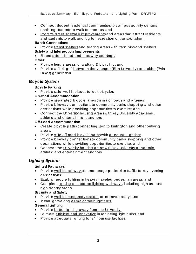
• Connect student residential communities to campus activity centers enabling students to walk to campus; and
• Prioritize street sidewalk improvements and areas that attract residents and students to walk and jog for recreation or transportation.
Transit Connections • Provide transit shelters and seating areas with trash bins and shelters. Safety and Intersection Improvements • Ensure safe railroad and roadway crossings. Other • Provide leisure areas for walking & bicycling; and • Provide a “bridge” between the younger (Elon University) and older (Twin
Lakes) generation.
Bicycle System Bicycle Parking • Provide safe, well lit places to lock bicycles. On-road Accommodation • Provide separated bicycle lanes on major roads and arteries; • Provide bikeway connections to community parks, shopping and other
destinations, while providing opportunities to exercise; and • Connect the University housing areas with key University academic,
athletic and entertainment anchors. Off-Road Accommodation • Create bicycle paths connecting Elon to Burlington and other outlying
areas; • Provide safe off-road bicycle paths with adequate lighting; • Provide bikeway connections to community parks, shopping and other
destinations, while providing opportunities to exercise; and • Connect the University housing areas with key University academic,
athletic and entertainment anchors.
Lighting System Lighted Pathways • Provide well lit pathways to encourage pedestrian traffic to key evening
destinations; • Establish secure lighting in heavily traveled pedestrian areas; and • Complete lighting on outdoor lighting walkways, including high use and
high density areas. Security and Safety • Provide well lit emergency stations to improve safety; and • Install lights along all major thoroughfares. General Lighting • Provide better lighting away from the University; • Be more efficient and innovative in replacing light bulbs; and • Provide adequate lighting for 24 hour use facilities.
Executive Summary – Elon Bicycle, Pedestrian and Lighting Plan - DRAFT #2
4
ALTERNATIVE TRANSPORTATION SYSTEM PLAN
Pedestrian, Bicycle and Lighting System Overview The Town of Elon has a nearly complete sidewalk network in the University and downtown areas providing a walkable town center around Williamson Avenue between Haggard and Lebanon Avenue. Twin Lakes Retirement Community and the Millpoint Subdivision also have sidewalk networks. There are quite a few small gaps in the pedestrian system that need to be filled. Section 3.2 summarizes pedestrian system recommendations. The on-street bicycle network in Elon consists of shared travel lanes and no dedicated on street facilities. North Carolina Bike Route 70 crosses the Town of Elon on Manning, Lebanon and Oak Street. Bicycling activity has been observed in Elon, especially while Elon University is in session, and a number of roadways have been proposed for installation of bicycle lanes or wide shoulders. The lane widths of commonly traveled roads in Elon are color coded on the existing Bicycling Facilities map in Chapter 2. The recently completed University Drive bypass and adjacent shared-use path is a promising result of recent policies adopted by the Town of Elon that call for bicycle and pedestrian accommodation for all new roads. Important to the future walkability and bikeability of this corridor will be the continuation of the shared-use path when phase II of the Cook Road/University Drive improvements begin in 2010. Other gateways into Elon include Haggard Avenue from Gibsonville and Williamson Avenue, Front Street and West Webb Avenue from Burlington. The lighting system in Elon consists of decorative lighting in the University area, downtown, Twin Lakes and some newer neighborhoods. Standard telephone pole mounted lights exist in older neighborhoods and along heavily traveled corridors such as Williamson and Haggard Avenue (outside the downtown and University area). There are several corridors where lighting coverage needs to be improved. Specific areas recommended for improvement are provided in Section 3.4 below. This Plan outlines a series of projects, programs and policy recommendations. Section 3.2, 3.3 and 3.4 pertain to project recommendations, which will require the largest amount of funding to complete. Projects are grouped by a) corridors, b) intersections and c) shared-use paths. Shared-use path recommendations focus on the creation of new corridor connections to parks, schools and shopping. Corridor projects are prioritized based on factors explained in the Appendix. Intersection projects are not prioritized and should be low cost enough to complete in a relatively short time period of 1-5 years. Chapter 3.7 provides more detail about the specific project recommendations in small area plans.
Executive Summary – Elon Bicycle, Pedestrian and Lighting Plan - DRAFT #2
5
Sidewalk and intersection improvements are considered on-road improvements, which offer safe pedestrian transportation options in existing street corridors. Shared-use path and trail improvements are considered off-road improvements and provide important long-term non-motorized connections near streams, sewer lines or other corridors. Bicycle lane facilities are considered on-road improvements. Lighting improvements include areas where gaps need to be filled or lighting quality and aesthetics need to be improved. Project improvements have been identified using the following sources and criteria:
a) public comments (survey, public meeting maps or questionnaire); b) higher traffic volume streets and intersections with observed high levels of walking behavior; c) safety concerns resulting from crash data and demographic analysis; d) proximity to trip generators (parks, schools, shopping, Downtown); e) steering committee recommendations f) previous plan recommendations (e.g. Land Development Plan); and g) project staff field analysis.
Executive Summary – Elon Bicycle, Pedestrian and Lighting Plan - DRAFT #2
6
Pedestrian System Recommendations The pedestrian facilities recommended for improvement include sidewalks, intersections and shared-use path facilities. The sidewalk corridor improvements have been prioritized using the factors shown below in Figure 3.1. The prioritization process used for corridor and intersection improvements combine factors used in the Graham, NC Pedestrian Transportation Plan (2006), the Durham, NC Pedestrian Transportation Plan (2006) and the Portland, OR Pedestrian Plan (1998). A wide range of factors were used for project prioritization, the higher the score, the higher the priority. The scoring system used to rate each project will serve as a guide to programming resources for projects. However, opportunities for improvement to certain corridors may arise (i.e. unplanned road projects, repaving projects, utility installation or specific funding opportunities) initiating the construction of projects that may not be a top priority. More detail on each of the factors and their value are found in the Appendix.
Figure 3.1 – Proposed Sidewalk Corridor Improvement
Project ID Side Street From ToLength
(ft) Exis
ting
Side
wal
k O
ppos
ite
Side
Publ
ic C
omm
ents
(5 to
10=
3;
11 to
20=
4; >
20=5
)Pr
oxim
ity to
sch
ool z
ones
(with
in 1
/4 m
ile =
3; 1
/2 =
2)
Prox
imity
to p
arks
and
recr
eatio
n (w
ithin
1/4
mile
= 3
; 1/
2 m
ile =
2)
Cra
shes
(1 c
rash
200
1-20
06)
Smal
l gap
s (<
1,00
0 ft)
Roa
d ty
pe (a
rteria
l or c
olle
ctor
>1
500A
DT)
Com
patib
le la
nd u
se (m
ulti-
fam
ily re
side
ntia
l, co
mm
erci
al,
inst
itutio
nal o
r dow
ntow
n)C
urb
and
gutte
r exi
stin
gC
onne
ctiv
ity to
exi
stin
g si
dew
alk
Pro
xim
ity to
Tra
nsit
(<1,
000f
t)Sc
ore
Tota
l
S-693, S-694, S-695 W WILLIAMSON AVENUE EXISTING SIDEWALK CHURCH STREET 7,320 5 3 3 2 0 3 3 2 2 0 23S-612 N E LEBANON AVENUE S OAK STREET KERR AVENUE 610 3 3 2 2 2 3 3 0 2 2 22S-617 N W LEBANON AVENUE CHURCH STREET MANNING AVENUE 520 3 2 3 0 2 3 3 2 2 2 22
S-619, S-690 N W HAGGARD AVENUE UNIVERSITY DRIVE HOLT AVENUE 1,965 5 3 2 0 0 3 3 2 2 2 22S-626, S-687 N E HAGGARD AVENUE LAWRENCE AVENUE UNIVERSITY DRIVE 6,110 5 3 2 0 0 3 3 2 2 2 22
S-607 S E TROLLINGER AVENUE S OAK STREET ANTIOCH AVENUE 880 4 3 2 2 2 3 3 0 2 0 21S-594 S W TROLLINGER AVENUE CHURCH STREET HOLT AVENUE 1,450 4 2 3 0 0 3 3 2 2 2 21
S-579, S-613, S-610 W OAK STREET E HAGGARD AVENUE TOWN LINE 2,080 4 3 3 2 0 3 3 0 0 2 20
S-712 E MANNING AVENUE LAUREL OAK STREET E HAGGARD AVENUE 1,520 3 2 2 0 0 3 3 0 2 2 17S-588, S-589, S-627 S E HAGGARD AVENUE EXISTING SIDEWALK UNIVERSITY DRIVE 5,110 5 0 0 0 0 3 3 0 0 2 13S-704, S-705, S-706 W WESTBROOK AVENUE MACLEAN DRIVE CHURCH STREET 6,890 4 0 2 0 0 3 0 0 2 2 13
S-711 E S O KELLEY AVENUE WOODALE DRIVE TROLLINGER AVENUE 1,470 0 2 2 0 0 0 3 2 2 0 11S-628 E TRUITT DRIVE WINDSOR WAY S OAK STREET 1,950 3 2 0 0 0 0 2 2 2 0 11S-689 N WESTGATE DRIVE WESTBROOK AVENUE WILLIAMSON AVENUE 1,710 0 0 0 0 0 0 0 0 0 0 0
Intersection improvement projects are shown below in Figure 3.2. These proposed improvements may include pedestrian refuge islands, curb ramps, crosswalks, traffic calming or other measures to increase pedestrian and bicycle safety. These improvements are not prioritized; however all of the intersections are in need of improvement and can be completed using minimal resources. A more detailed review of these intersections and what specific improvements are recommended can be found in the Small Area System Plan section.
Executive Summary – Elon Bicycle, Pedestrian and Lighting Plan - DRAFT #2
7
Figure 3.2 – Proposed Intersection Improvements
The following shared-use paths are proposed to connect neighborhoods and improve pedestrian and bicycle connections for transportation and recreation. These connections provide key access points to destinations including work, school, shopping and recreation. The top three projects were ranked by the steering committee.
Figure 3.3 – Proposed Shared Use Paths and Lengths
PROJECT ID LOCATIONS LENGTH
(FT) WIDTH
(FT) SURFACE RANKP-20 UNIVERSITY DRIVE 4,900 10 PAVED 1
P-31
SCHMIDT PARK AND BALL PARK AVENUE CONNECTOR 3,000 10 PAVED
2
P-43 RAMP FROM TWIN LAKES
TO SHARED-USE PATH 100 10 PAVED 3
P-30 RAILROAD CONNECTOR TO UNIVERSITY DRIVE 1,700 10 PAVED
n/a
P-32 TWIN LAKES CONNECTOR
TO UNIVERSITY DRIVE 1,400 10 PAVED n/a
P-33, P-44 OKELLEY, WESTOVER AND
MILLPOINT CONNECTOR 1,300 10 PAVED n/a
P-37 SCHMIDT PARK PATH
IMPROVEMENT 730 10 PAVED n/a
P-41 NEAL STREET CONNECTOR 690 10 NATURAL
n/a
P-42 MOUNTAINS TO SEA TRAIL
CONNECTOR 18,500* 10 NATURAL n/a
P-45
FORESTVIEW DRIVE AND NEAL STREET CONNECTOR 300 10 PAVED
n/a
P-46
ARBOR DRIVE AND HUTCHINSON CT
CONNECTOR 200 10 PAVED
n/a
*The distance of the MST Trail connection inside the town limits is approximately 8,750ft. There were nearly 28 miles of potential greenway trails identified in the 2002 Elon Land Development Plan, much of which extend into areas outside Elon’s city limits. As new development occurs, the Town of Elon should preserve previous and newly identified potential and proposed shared-use paths through the subdivision and easement acquisition process.
ID LOCATION I-1 TROLLINGER/LEBANON/RAILROAD & WILLIAMSON AVENUE I-2 TROLLINGER/LEBANON/RAILROAD & OAK STREET I-3 WESTBROOK ROAD & UNIVERSITY DRIVE I-5 HAGGARD AVENUE & OAK STREET I-6 HAGGARD AVENUE & MANNING AVENUE I-8 UNIVERSITY DRIVE & N OKELLEY AVE
Executive Summary – Elon Bicycle, Pedestrian and Lighting Plan - DRAFT #2
8
Map 3.1 - Proposed Pedestrian Facilities
Executive Summary – Elon Bicycle, Pedestrian and Lighting Plan - DRAFT #2
9
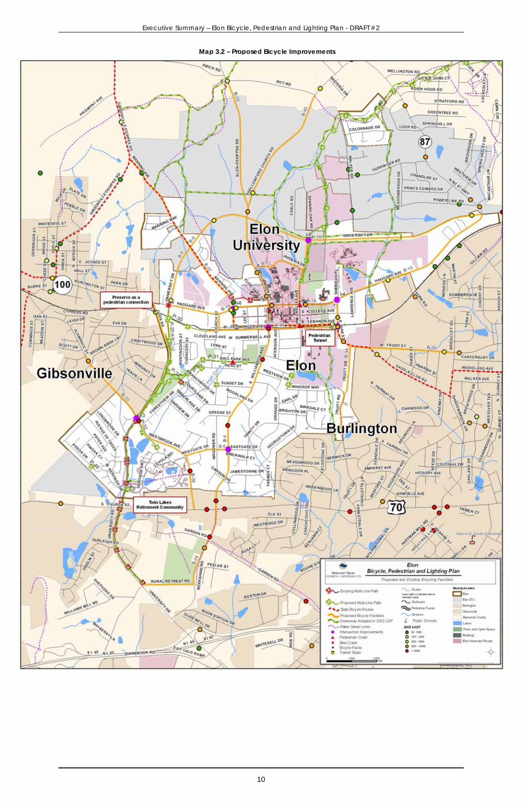
Bicycle System Recommendations The majority of the heavier traveled roads are proposed for bicycle improvements to facilitate bicycle transportation and recreation. The level of effort required to complete the facilities will vary based on existing pavement width, adjoining land uses, adjacent facilities, repaving schedules and other factors. The bicycle system recommendations are prioritized using a different set of factors from the pedestrian facilities. The ranked bicycle transportation improvements shown in Figure 3.4 indicate proposed improvements and existing travel lane width to install bicycle lanes, striping or some other improvements to facilitate bicycle travel while also accommodating motor vehicle travel. The higher the score total, the higher the rank. See the Small Area System Plan for further detail on specific facility recommendations. Map 3.2 displays on-road and off-road proposed bicycling system improvements. More detail on each of the factors and their value are found in the Appendix.
Figure 3.4 – Proposed On Road Bicycle Improvements with Priority Score
Project ID Street From/To Lane
Wid
th (f
t)
Leng
th (f
t)D
irect
Acc
ess
to a
Par
kD
irect
Acc
ess
to a
Sc
hool
or U
nive
rsity
Aver
age
Dai
ly T
raffi
c (A
DT);
1 (1
500-
5k);
2 (5
k-10
k); 3
(>10
k)Sp
eed
Lim
it - 1
(35-
44),
2 (4
5-54
) and
3 (>
55)
Tran
sit R
oute
C
onne
ctiv
ityC
rash
es
Con
nect
s to
Pro
pose
d or
Exis
ting
Gre
enw
ayD
irect
Acc
ess
to
Com
mer
cial
Dis
trict
Scor
e To
tal
B-2, B-3, B-4, B-23, B-24, B-25WILLIAMSON AVENUE & ST.
MARKS CHURCH ROADPHEONIX DRIVE TO RURAL
RETREAT ROAD 12 to 22 15,570 2 3 3 2 2 2 2 3 19
B-18, B-19 HAGGARD AVENUEOAK STREET TO
UNIVERSITY DRIVE 15 to 20 6,875 2 3 2 1 2 2 2 3 17
B-15 HAGGARD AVENUEW WEBB AVENUE TO OAK
STREET 12 6,950 0 3 2 2 2 2 2 3 16
B-5, B-35, B-36 WESTBROOK AVENUECHURCH STREET TO
MACLEAN DRIVE 10 10,400 2 0 3 1 2 0 2 3 13
B-37 MANNING AVENUEETJ LIMITS TO W
HAGGARD AVENUE 9 to 12 7,450 0 3 0 3 2 0 2 3 13
B-12, B-13 N O'KELLEY AVENUEE HAGGARD AVENUE TO
UNIVERSITY DRIVE 9 2,630 2 3 0 1 2 2 2 0 12
B-40
SHALLOWFORD CHURCH ROAD AND WILLIAMSON
AVENUEETJ LIMITS TO PHEONIX
DRIVE 10 7,910 0 3 1 2 2 0 2 2 12
B-6 UNIVERSITY DRIVEW HAGGARD AVENUE TO
WESTBROOK AVENUE 10 4,900 2 0 1 2 2 2 2 0 11
B-8, B-9, B-14, B-16 UNIVERSITY DRIVEW HAGGARD AVENUE TO E
HAGGARD AVENUE 12 to 15 11,290 0 0 1 3 2 2 2 0 10
B-26 OAK & FRONT STREETSE HAGGARD AVENUE TO
BRIERCLIFF ROAD 10 to 18 6,300 0 3 2 1 2 2 0 0 10
B-31MANNING & W LEBANON
AVENUEW HAGGARD AVENUE TO
OAK STREET 9 to 12 4,900 0 3 1 1 2 0 0 3 10
B-28 TROLLINGER AVENUEBALL PARK AVENUE TO
OAK STREET 11 5,300 0 0 1 1 2 0 2 3 9
B-11 PHOENIX DRIVEOKELLEY AVENUE TO WILLIAMSON AVENUE 12 2,100 0 3 0 0 2 0 2 0 7
B-29 CHURCH STREETHAGGARD AVENUE TO TROLLINGER AVENUE 9 620 0 0 0 1 2 0 0 3 6
B-32 COOK ROADBURLINGTON STREET TO
CROFTWOOD DRIVE 10 2,100 0 0 1 1 2 0 2 0 6
B-39 ELON-OSSIPPEE ROAD
ETJ LIMITS TO SHALLOWFORD CHURCH
ROAD 10 to 15 5,260 0 0 1 3 0 0 2 0 6
B-34 TRUITT DRIVEOAK STREET TO CITY
LIMITS 15 3,600 0 0 1 1 0 0 0 0 2
Executive Summary – Elon Bicycle, Pedestrian and Lighting Plan - DRAFT #2
10
Map 3.2 – Proposed Bicycle Improvements
Executive Summary – Elon Bicycle, Pedestrian and Lighting Plan - DRAFT #2
11
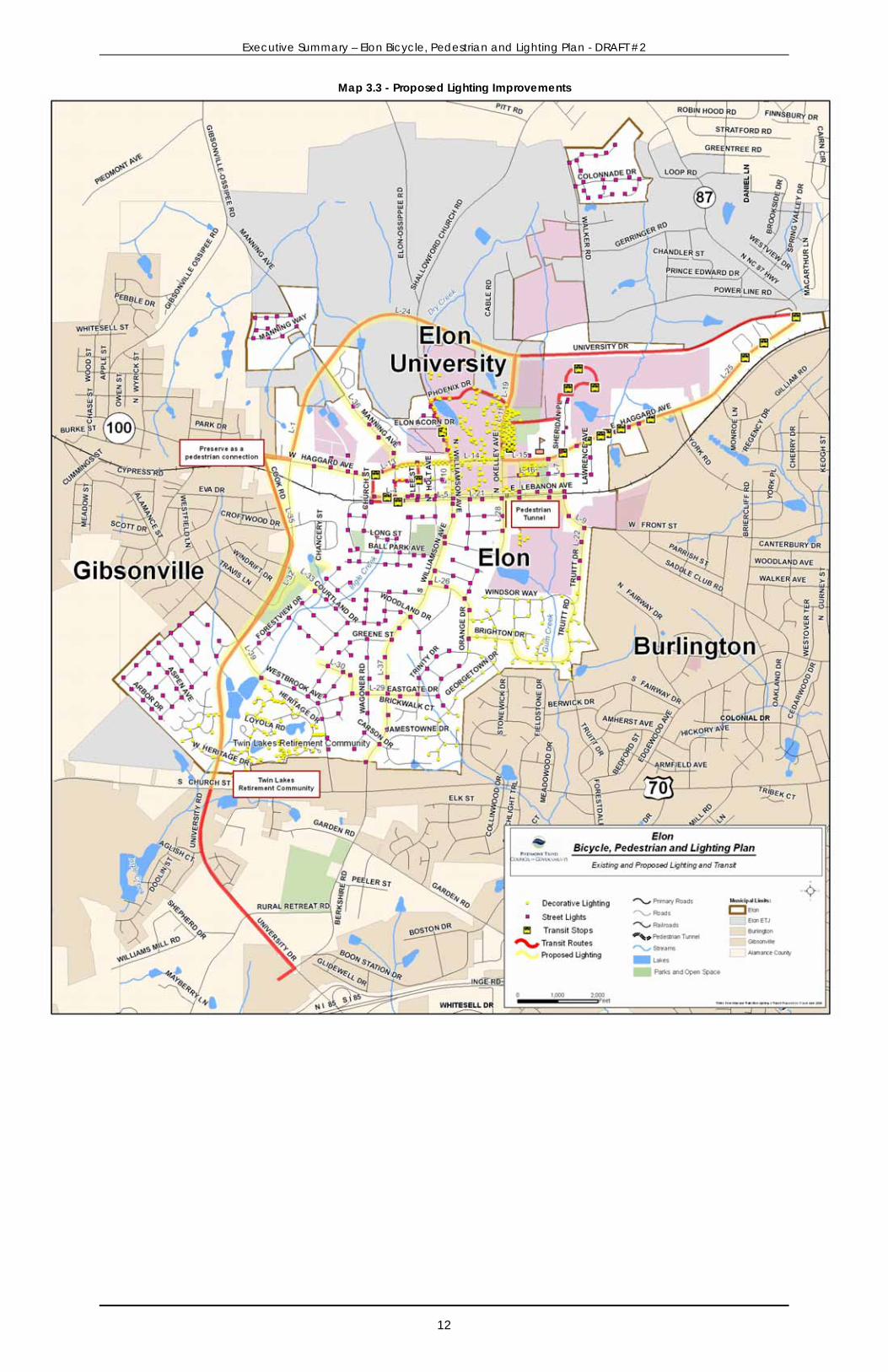
Lighting System Recommendations The lighting system in Elon needs to be improved in certain areas. The problem areas result from either gaps in lighting, aesthetically unpleasing lighting or insufficient light fixtures (e.g. wasted light away from the ground, low wattage, etc.). Figure 3.5 and Map 3.3 indicate existing corridors that need lighting improvements.
The distance between light fixtures should match the LDO requirement for new development, which calls for light fixtures to be spaced 160 to 200 feet apart. In the instance that new lighting installations will reduce the distance below the suggested spacing distance, consideration of adjusting pole height, wattage and foot candle should be managed through consultation with a lighting specialist or Duke Energy. Where there are transit stops, additional lighting should be installed at the stop for transit user safety.
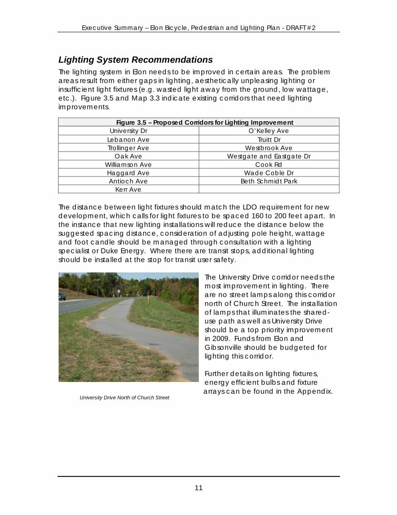
The University Drive corridor needs the most improvement in lighting. There are no street lamps along this corridor north of Church Street. The installation of lamps that illuminates the shared-use path as well as University Drive should be a top priority improvement in 2009. Funds from Elon and Gibsonville should be budgeted for lighting this corridor. Further details on lighting fixtures, energy efficient bulbs and fixture arrays can be found in the Appendix.
Figure 3.5 – Proposed Corridors for Lighting Improvement University Dr O’Kelley Ave
Lebanon Ave Truitt Dr Trollinger Ave Westbrook Ave
Oak Ave Westgate and Eastgate Dr Williamson Ave Cook Rd Haggard Ave Wade Coble Dr Antioch Ave Beth Schmidt Park
Kerr Ave
University Drive North of Church Street
Executive Summary – Elon Bicycle, Pedestrian and Lighting Plan - DRAFT #2
12
Map 3.3 - Proposed Lighting Improvements
Executive Summary – Elon Bicycle, Pedestrian and Lighting Plan - DRAFT #2
13
Policy and Program Recommendations the Town of Elon currently has a number of policies pertaining to bicycle and pedestrian transportation. The Land Development Ordinance calls for the preservation of open space and encourage pedestrian and bicycle travel through a number of existing regulations outlined in Chapter 2 of the full report.
Policy Recommendations and Ordinance Changes The following recommended changes build upon policies developed in the Town’s 2004 Land Development Ordinance and were suggested by the task force, project staff and public comment. Issue 1: Funding sidewalk construction in existing development Current Policy: Reliance upon the Town general fund, State transportation funding and donations to build new sidewalk. Recommended Policy: To supplement other sources of funding for sidewalk construction, the Town should set up a fair, but comprehensive assessment policy to facilitate and fund the development of a connected sidewalk system. Issue 2: Public access easements Current Policy: The Town does not currently acquire shared-use path, trail or other public access easements with sewer and water easements as lines are extended. Recommended Policy: As new sewer lines are extended along proposed greenway corridors recommended in this plan or along stream corridors, acquire public access easements for non-motorized users for both sewer line use and future trail use. Include a requirement in the subdivision ordinance that requires public access easements along proposed greenways when land is subdivided within the Town Limits and extra territorial zoning jurisdiction. Issue 3: Promoting mixed use zoning (e.g. Town Center, Village Center and Neighborhood Center) designation Current Policy: Few areas have been zoned to accommodate the mixed uses allowed in the above zoning districts. Recommended Policy: Proactively explore the possibility of designating more mixed-use districts in Elon. Creating mixed use districts will allow new development to have a range of uses thereby allowing shorter trips that can be made by foot or bicycle. Issue 4: Sidewalk requirements for change of use – all zoning districts
Executive Summary – Elon Bicycle, Pedestrian and Lighting Plan - DRAFT #2
14
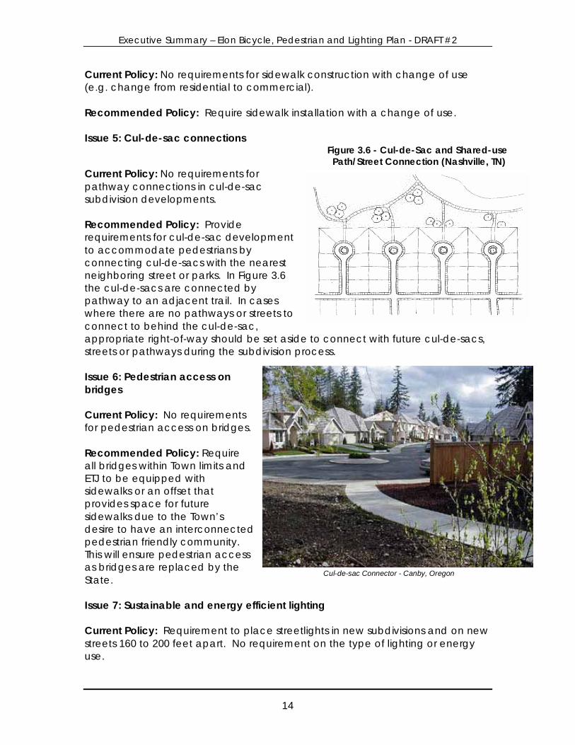
Current Policy: No requirements for sidewalk construction with change of use (e.g. change from residential to commercial). Recommended Policy: Require sidewalk installation with a change of use. Issue 5: Cul-de-sac connections Figure 3.6 - Cul-de-Sac and Shared-use
Path/Street Connection (Nashville, TN) Current Policy: No requirements for pathway connections in cul-de-sac subdivision developments. Recommended Policy: Provide requirements for cul-de-sac development to accommodate pedestrians by connecting cul-de-sacs with the nearest neighboring street or parks. In Figure 3.6 the cul-de-sacs are connected by pathway to an adjacent trail. In cases where there are no pathways or streets to connect to behind the cul-de-sac, appropriate right-of-way should be set aside to connect with future cul-de-sacs, streets or pathways during the subdivision process. Issue 6: Pedestrian access on bridges Current Policy: No requirements for pedestrian access on bridges. Recommended Policy: Require all bridges within Town limits and ETJ to be equipped with sidewalks or an offset that provides space for future sidewalks due to the Town’s desire to have an interconnected pedestrian friendly community. This will ensure pedestrian access as bridges are replaced by the State. Issue 7: Sustainable and energy efficient lighting Current Policy: Requirement to place streetlights in new subdivisions and on new streets 160 to 200 feet apart. No requirement on the type of lighting or energy use.
Cul-de-sac Connector - Canby, Oregon
Executive Summary – Elon Bicycle, Pedestrian and Lighting Plan - DRAFT #2
15
Recommended Policy: Require closer light spacing in high pedestrian activity centers and on major corridors. Explore lower wattage lights that also provide enough lumens for needed safety in Elon. Produce list of sustainable lighting vendors to share with developers and seek input yearly to update list and keep current. Issue 8: Complete Streets Current Policy: The Town of Elon requires the provision of a “complete street” when new roads are developed, which include provisions for sidewalks, bicycle paths and/or bicycle lanes. Recommended Policy: Adopt the “Complete Streets” policy for all existing road reconstruction, in addition to new construction. The policy would require that roads being resurfaced also be evaluated to include bicycle lanes and sidewalks. Issue 9: Scenic Corridor Overlay District Current Policy: No current overlay district Recommended Policy: Work with the Appearance Commission to create this new overlay district to help beautify and preserve major and minor thoroughfares. The features would include lighting specifications, landscape requirements, signage requirements and other features to improve and preserve scenic beauty. Issue 10: Decorative Lighting Overlay District Current Policy: No current overlay district Recommended Policy: Create this new overlay district to include detail on aesthetic and energy efficient design, spacing requirements, foot candle and lumens. Create the first district in the downtown area. Issue 11: Require shared-use pathways along existing major arterials Current Policy: Shared-use pathways and/or sidewalks are required for new roads. Recommended Policy: Conduct a study to determine the feasibility of shared-use pathways along existing arterial corridors with few driveway cuts (i.e. existing University Drive) and sidewalks along arterial and collector corridors with significant driveway cuts. Require construction of pathways or sidewalk when new land development occurs.

Executive Summary – Elon Bicycle, Pedestrian and Lighting Plan - DRAFT #2
16
Issue 12: Trail access under new road bridges Current Policy: None Recommended Policy: Require that road bridge design accommodate future trail development where greenways or conservation areas are proposed – or within ½ mile of parks or schools. Conduct a study that identifies the feasibility of trail development under existing bridges in the town limits and ETJ.
Program Recommendations Coordination with other municipalities on bicycle and pedestrian transportation Elon participates in the Burlington-Graham MPO Transportation Advisory Committee, responsible for transportation funding and issues in all of Alamance County and its municipalities. Encourage the development of a bicycle and pedestrian transportation advisory committee to the MPO that will work to refine and develop regional bicycle and pedestrian transportation initiatives that connect across municipal lines, encourage active transportation, cleaner air and personal health. Establish Streetscape Committee Establish a streetscape committee, under the Appearance Commission to target specific routes identified in this plan for lighting, trees and landscaping along existing streets & roads. The streetscape committee could also explore a traffic calming program in coordination with streetscape enhancements. Enhance lighting to accommodate and encourage pedestrian or bicycle travel. Sidewalk Art Program Encourage creative use of public sidewalks within the downtown area(i.e. ability to set up chairs, apply for art enhancements on the sidewalk, etc.). Help businesses develop a theme or design for the sidewalk in front of their stores and shops in cooperation with Elon University classes. Work with the newly established streetscape committee and the existing appearance commission to implement the program and supply seed funding for the first year of this program. Bicycle Route Maintenance The state bicycle route through Elon as well as any bicycle facilities that are installed should be cleaned regularly to avoid collecting debris that will discourage bicycling on these facilities as well as reduce safety. Bicycle Parking Program Elon University provides bicycle parking on campus and bicycle racks are required in new multi-family or commercial development. However, existing developments lack ample bicycle parking. The Town, neighboring jurisdictions and the Burlington-
Campus Bike Rack

Executive Summary – Elon Bicycle, Pedestrian and Lighting Plan - DRAFT #2
17
Graham Metropolitan Planning Organization should assess needs and provide funds for a bicycle parking program across the region. Bicycle racks and lockers should be placed at key locations (e.g. shopping centers, downtown areas, community centers, etc.) to encourage bicycle travel. Crosswalk Spot Improvement Program Regularly check existing crosswalks for wear and tear and work to repaint or tape existing crosswalks to improve visibility. Work to identify crossing locations that may need additional treatments such as in-pavement crosswalk signs, stamped pavement or other features to slow traffic and increase pedestrian safety. Benches and Plantings Provide more sidewalk space and plantings around benches in the downtown and Haggard Avenue where space allows. Consider sidewalk width expansion in key locations. Consider adding more benches as well. Establish a Downtown Walking Promotion Program Working with the County Department of Health, Twin Lakes, the University, downtown businesses and neighborhoods, establish walking programs in the downtown and Beth Schmidt Park. Encourage participants to walk or bicycle to the event. The programs can be organized by individual employers/employees or among different employers and employees. The program will benefit the health of Elon citizens by increasing daytime and evening physical activity, while reducing health care costs, making workers more productive and reducing stress. In the first year, a pilot program for either downtown or Beth Schmidt Park is appropriate. The program should then be evaluated for effectiveness, improved, adjusted and then expanded to other locations if there is interest. Pedestrian Laws Training Program This program created by the NCDOT Bicycle and Pedestrian Program is designed for children, adults or police. The program should cover the following topics: Right-of-way at crosswalks, right turn on red, yielding to vehicles, walking on roadways without sidewalks, railroad crossings and more. More information about North Carolina pedestrian laws can be found here: http://www.ncdot.org/transit/bicycle/laws/resources/lawsguidebook.html . Adopt a Road / Adopt a Sidewalk Programs Adopt a Road programs are seen in many communities across North Carolina. The program provides resources to the community to sponsor and help to clean up road litter. The Town of Elon can begin a similar program for its sidewalks and (future) shared-use paths. This program could also be used as a means for the community to alert the Town when there is a maintenance issue with a sidewalk,
Photo: Dan Burden
Executive Summary – Elon Bicycle, Pedestrian and Lighting Plan - DRAFT #2
18
or as a means for a sidewalk to get special attention, funding, and improvements because of the dedication of its community sponsor. If effective, the quality of the sidewalk system will increase significantly.
Safe Routes to School Programs (SRTS) The Safe Routes to School program is a national and international movement to enable and encourage children, including those with disabilities, to walk and bicycle to school. Safe Routes to School programs are comprehensive efforts that look at ways to make walking and bicycling to school a safer and more appealing
transportation alternative, thus encouraging a healthy and active lifestyle from an early age. The North Carolina SRTS program http://www.ncdot.org/transit/bicycle/saferoutes/SafeRoutes.html is administered by the North Carolina Department of Transportation Bicycle and Pedestrian Transportation Program. There is funding available for a broad spectrum of initiatives including, but not limited to:
• Walking school bus programs (i.e. groups of students and parents/teachers walking to school) www.walkingschoolbus.org;
• Crossing guard training; • One-time walking and bicycling safety events (i.e. bicycle rodeos,
safety and health awareness fairs, walk to school day - www.walktoschool.org);
• Safety curriculum (i.e. printing safety curriculum and training for teachers);
• Bicycling and walking improvements (i.e. sidewalks, paths, bike parking, bike lanes, crossing treatments); and
• Weekly walking or bicycling programs (i.e. walking Wednesdays, Walk across America).
Many of the SRTS programs take few resources to get started (aside from bicycling and walking facility improvements), however a “local champion” will be needed to start and implement Safe Routes to School programs. The “local champion” will likely be a parent or teacher who can lead the effort on Safe Routes to School. This is a significant opportunity to fund programs educating and encouraging both students and parents about the benefits of walking or bicycling to school. Tree Programs Explore enhanced tree planting and preservation programs for the Town of Elon. Build on existing programs, encourage quality tree cover through the efforts of the Tree Preservation Committee. Basic requirements of the enhanced ordinance should include:
• If trees are cut down, replacement trees should be of equal or greater than the diameter of the trees cut, multiple trees can be planted where the sum of the diameters are equal to the diameter of the trees cut down;
Executive Summary – Elon Bicycle, Pedestrian and Lighting Plan - DRAFT #2
19
• Provide more detailed guidance on the types of trees and landscaping for commercial and retail areas; and
• Provide a certified part-time ISA arborist to educate and enforce the ordinance.
Some cities have worked with the utility company to provide free saplings and trees to customers. In addition education for citizens, businesses and developers about affordable and quality trees can be beneficial to improve the tree canopy, property aesthetics and the pedestrian experience.
Executive Summary – Elon Bicycle, Pedestrian and Lighting Plan - DRAFT #2
20
Small Area System Plan Overview and Recommendations
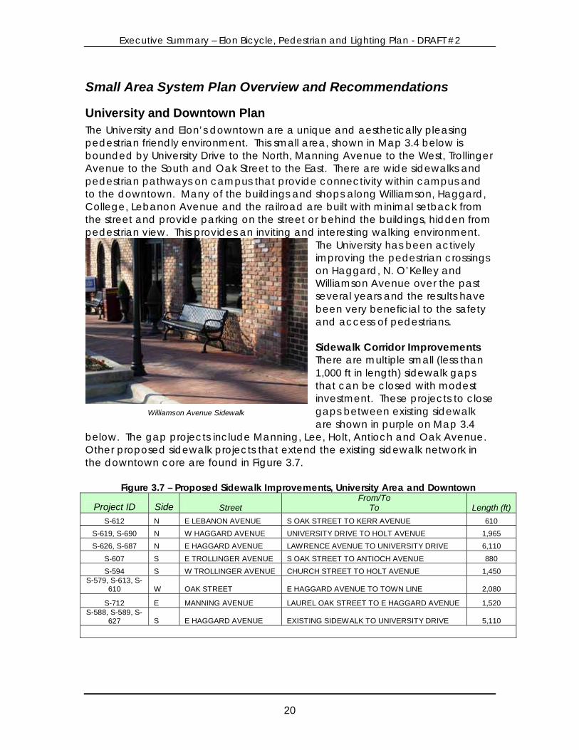
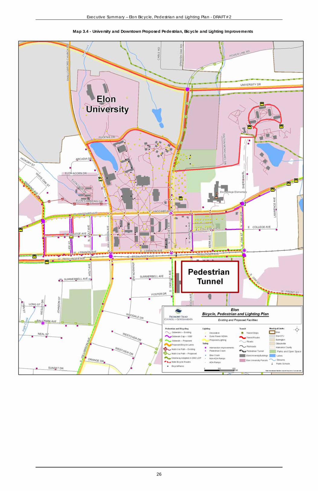
University and Downtown Plan The University and Elon’s downtown are a unique and aesthetically pleasing pedestrian friendly environment. This small area, shown in Map 3.4 below is bounded by University Drive to the North, Manning Avenue to the West, Trollinger Avenue to the South and Oak Street to the East. There are wide sidewalks and pedestrian pathways on campus that provide connectivity within campus and to the downtown. Many of the buildings and shops along Williamson, Haggard, College, Lebanon Avenue and the railroad are built with minimal setback from the street and provide parking on the street or behind the buildings, hidden from pedestrian view. This provides an inviting and interesting walking environment.
The University has been actively improving the pedestrian crossings on Haggard, N. O’Kelley and Williamson Avenue over the past several years and the results have been very beneficial to the safety and access of pedestrians. Sidewalk Corridor Improvements There are multiple small (less than 1,000 ft in length) sidewalk gaps that can be closed with modest investment. These projects to close gaps between existing sidewalk are shown in purple on Map 3.4
below. The gap projects include Manning, Lee, Holt, Antioch and Oak Avenue. Other proposed sidewalk projects that extend the existing sidewalk network in the downtown core are found in Figure 3.7.
Figure 3.7 – Proposed Sidewalk Improvements, University Area and Downtown
Project ID Side Street From/To
To Length (ft) S-612 N E LEBANON AVENUE S OAK STREET TO KERR AVENUE 610
S-619, S-690 N W HAGGARD AVENUE UNIVERSITY DRIVE TO HOLT AVENUE 1,965
S-626, S-687 N E HAGGARD AVENUE LAWRENCE AVENUE TO UNIVERSITY DRIVE 6,110
S-607 S E TROLLINGER AVENUE S OAK STREET TO ANTIOCH AVENUE 880
S-594 S W TROLLINGER AVENUE CHURCH STREET TO HOLT AVENUE 1,450 S-579, S-613, S-
610 W OAK STREET E HAGGARD AVENUE TO TOWN LINE 2,080
S-712 E MANNING AVENUE LAUREL OAK STREET TO E HAGGARD AVENUE 1,520 S-588, S-589, S-
627 S E HAGGARD AVENUE EXISTING SIDEWALK TO UNIVERSITY DRIVE 5,110
Williamson Avenue Sidewalk
Executive Summary – Elon Bicycle, Pedestrian and Lighting Plan - DRAFT #2
21
Bicycle Corridor Improvements Many of the downtown streets have been proposed for bicycle facility improvements. However, many of the streets will require additional pavement width to easily accommodate bicyclists. The downtown streets in Figure 3.8 have been identified for improvements. Generally where width is sufficient, this space can be reserved for future bicycle lanes, however ample width on continuous segments on both sides of the road should be achieved prior to bicycle lane designation. Completing a dedicated facility for the entire segment will avoid confusion and create a better overall bicycling facility. When future paving projects are planned, adding width to accommodate a wide outside curb lane (e.g. the travel lane closest to the curb) or bicycle lane should be included for the following road segments.
Figure 3.8 – Proposed Bicycle Facility Improvements, University Area and Downtown
Project ID Corridor From/To Lane Width (ft)
Improvement Length (ft)
B-2, B-3, B-4, B-23, B-24,
B-25
WILLIAMSON AVENUE & ST. MARKS CHURCH
ROAD HAGGARD AVENUE TO RURAL RETREAT ROAD 12 to 22
Bicycle lane with road reconstruction;
Sharrow from Haggard to Trollinger 13,990
B-15, B-18, B-19 HAGGARD AVENUE
UNIVERSITY DRIVE TO W WEBB AVENUE 12 to 20
Bicycle lane and share the road signs 6,400
B-12, B-13 N O'KELLEY AVENUE E HAGGARD AVENUE TO
UNIVERSITY DRIVE 9 Share the road signs
2,630
B-6 UNIVERSITY DRIVE W HAGGARD AVENUE TO
WESTBROOK AVENUE 10
4 foot paved shoulder with road
reconstruction 4,900
B-11, B-25
SHALLOWFORD CHURCH ROAD AND
WILLIAMSON AVENUE UNIVERSITY DRIVE TO W
HAGGARD AVENUE 10 to 22
Bicycle lane with road reconstruction and share the road
signs 7,700
B-8, B-9, B-14, B-16 UNIVERSITY DRIVE
W HAGGARD AVENUE TO E HAGGARD AVENUE 12 to 15
4 foot paved shoulder with road
resurfacing 11,290
B-26 OAK & FRONT STREETS E HAGGARD AVENUE TO
BRIERCLIFF ROAD 10 to 18
Bicycle lane with road reconstruction and share the road
signs 6,300
B-31 MANNING & W LEBANON
AVENUE W HAGGARD AVENUE TO
OAK STREET 9 to 12 Share the road signs
4,900
B-28 TROLLINGER AVENUE BALL PARK AVENUE TO OAK
STREET 11 Share the road signs
5,300
B-11 PHOENIX DRIVE OKELLEY AVENUE TO WILLIAMSON AVENUE 12
Share the road signs 2,100
Executive Summary – Elon Bicycle, Pedestrian and Lighting Plan - DRAFT #2
22
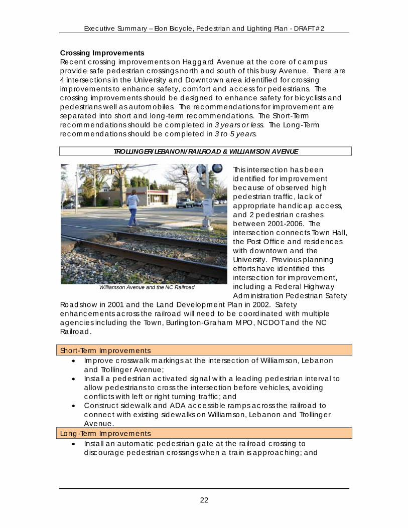
Williamson Avenue and the NC Railroad
Crossing Improvements Recent crossing improvements on Haggard Avenue at the core of campus provide safe pedestrian crossings north and south of this busy Avenue. There are 4 intersections in the University and Downtown area identified for crossing improvements to enhance safety, comfort and access for pedestrians. The crossing improvements should be designed to enhance safety for bicyclists and pedestrians well as automobiles. The recommendations for improvement are separated into short and long-term recommendations. The Short-Term recommendations should be completed in 3 years or less. The Long-Term recommendations should be completed in 3 to 5 years.
This intersection has been identified for improvement because of observed high pedestrian traffic, lack of appropriate handicap access, and 2 pedestrian crashes between 2001-2006. The intersection connects Town Hall, the Post Office and residences with downtown and the University. Previous planning efforts have identified this intersection for improvement, including a Federal Highway Administration Pedestrian Safety
Roadshow in 2001 and the Land Development Plan in 2002. Safety enhancements across the railroad will need to be coordinated with multiple agencies including the Town, Burlington-Graham MPO, NCDOT and the NC Railroad. Short-Term Improvements
• Improve crosswalk markings at the intersection of Williamson, Lebanon and Trollinger Avenue;
• Install a pedestrian activated signal with a leading pedestrian interval to allow pedestrians to cross the intersection before vehicles, avoiding conflicts with left or right turning traffic; and
• Construct sidewalk and ADA accessible ramps across the railroad to connect with existing sidewalks on Williamson, Lebanon and Trollinger Avenue.
Long-Term Improvements • Install an automatic pedestrian gate at the railroad crossing to
discourage pedestrian crossings when a train is approaching; and
TROLLINGER/LEBANON/RAILROAD & WILLIAMSON AVENUE
Executive Summary – Elon Bicycle, Pedestrian and Lighting Plan - DRAFT #2
23
Oak St. and Haggard Ave. Looking East on Haggard Ave.
• Construct a well-designed, aesthetically pleasing fence along the NC Railroad right-of-way to discourage pedestrians from crossing the railroad tracks, except at designated crossings.
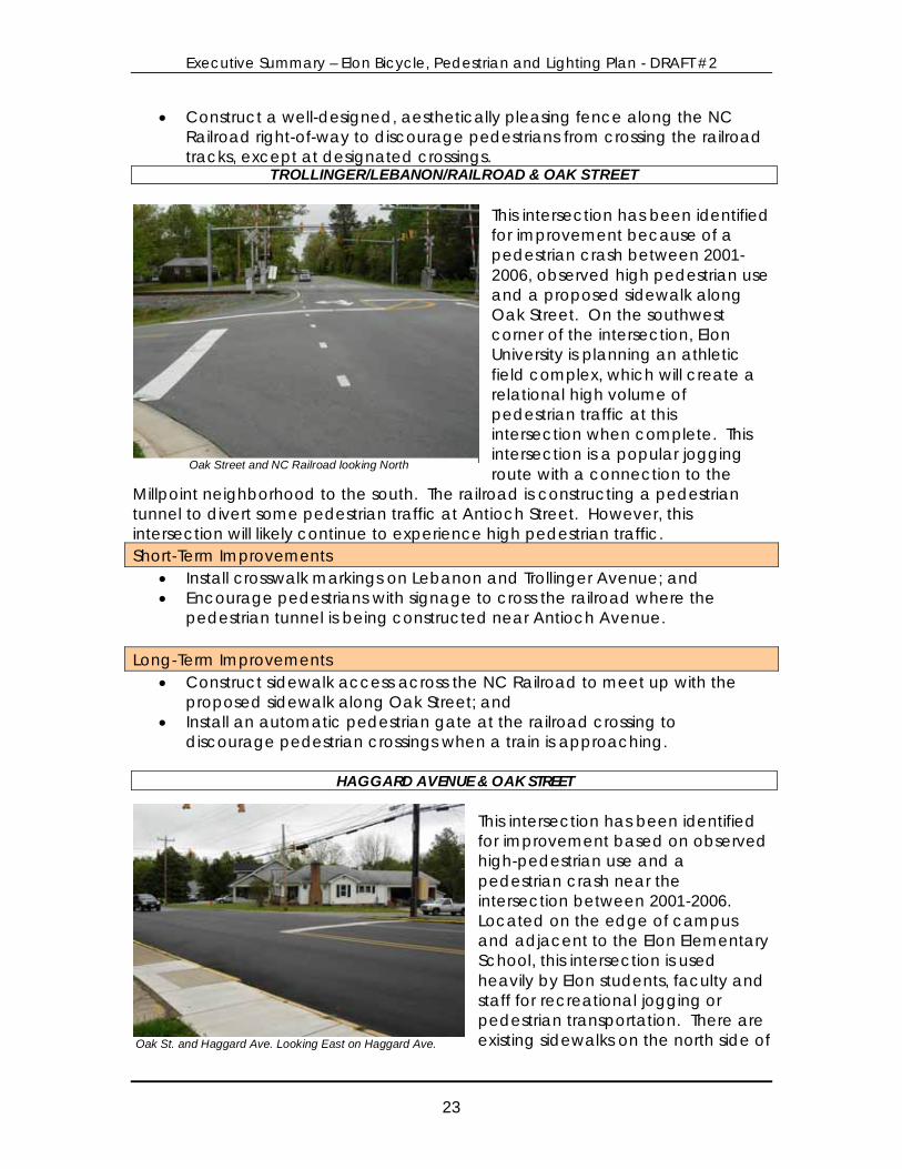
This intersection has been identified for improvement because of a pedestrian crash between 2001-2006, observed high pedestrian use and a proposed sidewalk along Oak Street. On the southwest corner of the intersection, Elon University is planning an athletic field complex, which will create a relational high volume of pedestrian traffic at this intersection when complete. This intersection is a popular jogging route with a connection to the
Millpoint neighborhood to the south. The railroad is constructing a pedestrian tunnel to divert some pedestrian traffic at Antioch Street. However, this intersection will likely continue to experience high pedestrian traffic. Short-Term Improvements
• Install crosswalk markings on Lebanon and Trollinger Avenue; and • Encourage pedestrians with signage to cross the railroad where the
pedestrian tunnel is being constructed near Antioch Avenue. Long-Term Improvements
• Construct sidewalk access across the NC Railroad to meet up with the proposed sidewalk along Oak Street; and
• Install an automatic pedestrian gate at the railroad crossing to discourage pedestrian crossings when a train is approaching.
This intersection has been identified for improvement based on observed high-pedestrian use and a pedestrian crash near the intersection between 2001-2006. Located on the edge of campus and adjacent to the Elon Elementary School, this intersection is used heavily by Elon students, faculty and staff for recreational jogging or pedestrian transportation. There are existing sidewalks on the north side of
TROLLINGER/LEBANON/RAILROAD & OAK STREET
HAGGARD AVENUE & OAK STREET
Oak Street and NC Railroad looking North

Executive Summary – Elon Bicycle, Pedestrian and Lighting Plan - DRAFT #2
24
this intersection along Haggard Avenue. Sidewalks are proposed on the west side of Oak Street heading south. Short-Term Improvements
• Install crosswalk markings on Haggard Avenue; and • Install curb ramps facing Haggard Avenue at the northwestern and
southwestern corner of the intersection to create better connection with the future sidewalk on Oak Street south of the intersection.
Long-Term Improvements
• Install a pedestrian activated signal and leading pedestrian interval to allow pedestrians to cross the intersection avoiding conflicts with turning traffic; and
• Improve the sidewalk across the Sheridan Place driveway apron providing a level sidewalk surface.
This intersection was identified for improvement based on comments from the steering committee and the general public. Although there have not been any reported bicycle or pedestrian crashes at this intersection, pedestrian traffic has been observed. There are a number of residences along Manning Avenue north of this intersection, which are within walking distance of the downtown.
Short-Term Improvements
• Install crosswalk markings on Haggard Avenue; • Install curb ramps facing Haggard Avenue at the southeastern and
northeastern corner of the intersection; and • Install in-pavement “yield to pedestrians in crosswalk” sign bollards.
Lighting Improvements Most of the downtown streets are indicated for improvements to lighting. Infill lighting should match existing light fixtures and pole heights from adjacent areas. Where sidewalk or pathway projects are proposed, lighting improvements should be made at the time of sidewalk construction. Strong consideration should be given to the use of decorative and sustainable lighting fixtures and placement of utility lines underground. The following streets in the downtown and University area need gaps in the existing lighting system filled.
HAGGARD AVENUE & MANNING AVENUE
Haggard and Manning Avenue looking north
Executive Summary – Elon Bicycle, Pedestrian and Lighting Plan - DRAFT #2
25
• Williamson Avenue south of Trollinger Avenue; • Haggard Avenue from Manning Avenue to Oak Avenue; • N. O’Kelley Avenue from Lebanon Avenue to Phoenix Drive; • Oak Avenue from Haggard Avenue to Truitt Drive; • Lebanon Avenue from Manning to Oak Avenue; • Trollinger Avenue from Church Street to Oak Avenue; • Antioch Avenue; • College Avenue; and • Kerr Avenue.
Executive Summary – Elon Bicycle, Pedestrian and Lighting Plan - DRAFT #2
26
Map 3.4 - University and Downtown Proposed Pedestrian, Bicycle and Lighting Improvements
Executive Summary – Elon Bicycle, Pedestrian and Lighting Plan - DRAFT #2
27
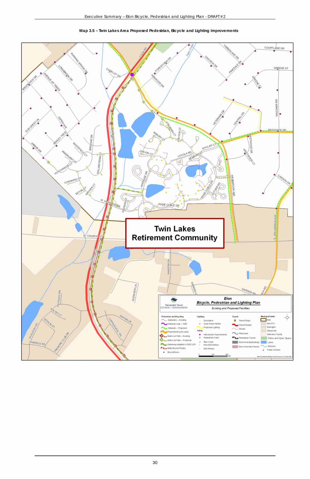
Twin Lakes Area Plan The Twin Lakes Retirement Community is located on the southwestern edge of Elon. The City of Burlington lies to the south and east and Gibsonville lies to the north and west. The community was completed in 1983 and has over 300 independent living residences which are supported by recreation and health service facilities. There are a number of different sidewalks and walking paths in the community, affording residents an opportunity for healthy and active lifestyle options. The community is located about ½ mile from Beth Schmidt Park and is bisected by University Drive. Pathway connections are proposed to link Twin Lakes to both Beth Schmidt Park (ID # P-32) and the shared-use pathway along University Drive (ID # P-43). Sidewalk Corridor Improvements Two sidewalk projects are proposed for the Twin Lakes area shown in Figure 3.9. A sidewalk is proposed along Westbrook Avenue to connect the Twin Lakes Retirement Community to shops and restaurants along Church Street. In addition a sidewalk is proposed along Westgate Drive to connect with a sidewalk proposed along Williamson Avenue.
Figure 3.9 – Proposed Sidewalk Corridor Projects, Twin Lakes Area Project ID Side Street From/To Length (ft)
S-704, S-705, S-706 W WESTBROOK AVENUE MACLEAN DRIVE TO CHURCH STREET 6,890
S-689 N WESTGATE DRIVE WESTBROOK AVENUE TO WILLIAMSON AVENUE 1,710
Bicycle Corridor Improvements There are two roads adjacent to the Twin Lakes Retirement Community proposed for bicycle facility improvement, Westbrook Avenue and Westgate Drive. The roadway will need to be widened at least 9 feet to accommodate 4-foot bicycle lanes in both directions on Westgate and Westbrook Avenue. Sight distance issues near the intersection of Westgate and Westbrook Avenue should be explored and mitigated through landscape control or a flashing light showing the approach of oncoming traffic.
Figure 3.10 – Proposed Bicycle Corridor Projects
Project ID Corridor From/To Lane Width (ft)
Improvement Length (ft)
B-5, B-35, B-36
WESTBROOK AVENUE AND WESTGATE
AVENUE
CHURCH STREET TO MACLEAN DRIVE AND WILLIAMSON AVENUE 10
Bicycle lane with road reconstruction
10,400
Executive Summary – Elon Bicycle, Pedestrian and Lighting Plan - DRAFT #2
28
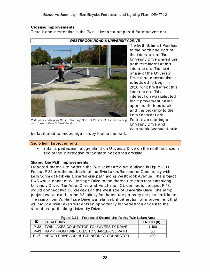
Crossing Improvements There is one intersection in the Twin Lakes area proposed for improvement.
The Beth Schmidt Park lies to the north and east of the intersection. The University Drive shared use path terminates at this intersection. The next phase of the University Drive road construction is scheduled to begin in 2010, which will effect this intersection. This intersection was selected for improvement based upon public feedback and the proximity to the Beth Schmidt Park. Pedestrian crossing of University Drive and Westbrook Avenue should
be facilitated to encourage trips by foot to the park. Short-Term Improvements
• Install a pedestrian refuge island on University Drive on the north and south side of the intersection to facilitate pedestrian crossing.
Shared Use Path Improvements Proposed shared-use paths in the Twin Lakes area are outlined in Figure 3.11. Project P-32 links the north side of the Twin Lakes Retirement Community with Beth Schmidt Park via a shared-use path along Westbrook Avenue. The project P-43 would connect W. Heritage Drive to the shared use path that runs along University Drive. The Arbor Drive and Hutchinson Ct. connector, project P-43, would connect two cul-de-sacs on the west side of University Drive. The ramp project was ranked as the #3 priority for shared use paths by the plan task force. The ramp from W. Heritage Drive is a relatively short section of improvement that will provide Twin Lakes residents an opportunity for pedestrian access to the shared use path along University Drive.
Figure 3.11 – Proposed Shared Use Paths, Twin Lakes Area ID LOCATIONS LENGTH (ft)
P-32 TWIN LAKES CONNECTOR TO UNIVERSITY DRIVE 1,400 P-43 RAMP FROM TWIN LAKES TO SHARED-USE PATH 50 P-46 ARBOR DRIVE AND HUTCHINSON CT CONNECTOR 200
WESTBROOK ROAD & UNIVERSITY DRIVE
Pedestrian Looking to Cross University Drive at Westbrook Avenue (facingnorth towards Beth Schmidt Park)
Executive Summary – Elon Bicycle, Pedestrian and Lighting Plan - DRAFT #2
29
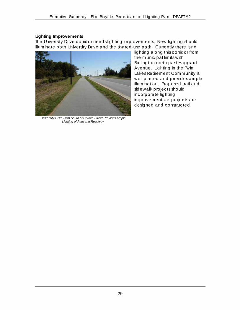
Lighting Improvements The University Drive corridor needs lighting improvements. New lighting should illuminate both University Drive and the shared-use path. Currently there is no
lighting along this corridor from the municipal limits with Burlington north past Haggard Avenue. Lighting in the Twin Lakes Retirement Community is well placed and provides ample illumination. Proposed trail and sidewalk projects should incorporate lighting improvements as projects are designed and constructed.
University Drive Path South of Church Street Provides Ample Lighting of Path and Roadway
Executive Summary – Elon Bicycle, Pedestrian and Lighting Plan - DRAFT #2
30
Map 3.5 – Twin Lakes Area Proposed Pedestrian, Bicycle and Lighting Improvements

Executive Summary – Elon Bicycle, Pedestrian and Lighting Plan - DRAFT #2
31
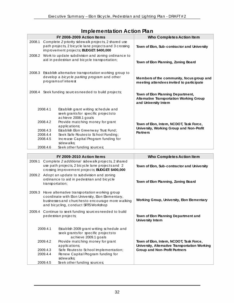
IMPLEMENTATION Effective implementation of recommended projects, programs and policies outlined in this plan will require the sustained, focused and coordinated efforts by Town leaders, the University and the public. The schedule of action items on the following page outlines how plan recommendations can be implemented and the entities with primary responsibility for carrying out each action item. The Town of Elon should capitalize on unplanned road projects or other opportunities that may take precedence over scheduled action items. The list of action items should be reviewed and evaluated by Town staff and reprioritized every 2 years. In addition to maintaining a list of completed projects, the Town should conduct an annual audit of sidewalk, bike lane and lighting systems to identify changing issues and focus resources efficiently.
Action Plan A step-by-step implementation process is detailed for the next 2 years. The action items are grouped by year and in most cases are not in sequential order. The suggested party or parties who need to complete each action step is also included. Opportunities to implement certain action items may arise before others and these opportunities should be pursued. The action items below are a menu of options for the Town of Elon to pursue as time, resources and political will allow. One of the most important action items is the formation of an alternative transportation working group. The working group will advocate for implementation of the plan and assist in public outreach and grant writing, Town staff communication and other duties. The working group will likely be involved in each of the action items, and will need to recruit new members to share the work load and maintain active participation. If there are budgetary implications for action items, the budget amount is indicated. Each new project or program and policy change should be evaluated for effectiveness as needed. In 2013, a broader assessment and evaluation of efforts should be performed to both look at proposed changes and their progress, but also to look at new ideas and new challenges.
Executive Summary – Elon Bicycle, Pedestrian and Lighting Plan - DRAFT #2
32
Implementation Action Plan FY 2008-2009 Action Items Who Completes Action Item
2008.1 Complete 2 priority sidewalk projects, 2 shared use path projects, 2 bicycle lane projects and 3 crossing improvement projects; BUDGET: $400,000
Town of Elon, Sub-contractor and University
2008.2 Work to update subdivision and zoning ordinance to aid in pedestrian and bicycle transportation; Town of Elon Planning, Zoning Board
2008.3 Establish alternative transportation working group to develop a bicycle parking program and other programs of interest
Members of the community, focus group and meeting attendees invited to participate
2008.4 Seek funding sources needed to build projects; Town of Elon Planning Department, Alternative Transportation Working Group and University Intern
2008.4.1 Establish grant writing schedule and seek grants for specific projects to achieve 2008.1 goals
2008.4.2 Provide matching money for grant applications;
2008.4.3 Establish Elon Greenway Trust Fund; 2008.4.4 Seek Safe Routes to School Funding; 2008.4.5 Increase Capital Program funding for
sidewalks; 2008.4.6 Seek other funding sources;
Town of Elon, Intern, NCDOT, Task Force, University, Working Group and Non-Profit Partners
FY 2009-2010 Action Items Who Completes Action Item
2009.1 Complete 2 additional sidewalk projects, 2 shared use path projects, 2 bicycle lane projects and 2 crossing improvement projects; BUDGET: $400,000
Town of Elon, Sub-contractor and University
2009.2 Adopt an update to subdivision and zoning ordinance to aid in pedestrian and bicycle transportation; Town of Elon Planning, Zoning Board
2009.3 Have alternative transportation working group coordinate with Elon University, Elon Elementary, businesses and churches to encourage more walking and bicycling, conduct SRTS Workshop
Working Group, University, Elon Elementary
2009.4 Continue to seek funding sources needed to build pedestrian projects; Town of Elon Planning Department and
University Intern
2009.4.1 Establish 2009 grant writing schedule and seek grants for specific projects to achieve 2009.1 goals
2009.4.2 Provide matching money for grant applications;
2009.4.3 Safe Routes to School Implementation; 2009.4.4 Renew Capital Program funding for
sidewalks; 2009.4.5 Seek other funding sources;
Town of Elon, Intern, NCDOT, Task Force, University, Alternative Transportation Working Group and Non-Profit Partners

Executive Summary – Elon Bicycle, Pedestrian and Lighting Plan - DRAFT #2
Executive Summary – Elon Bicycle, Pedestrian and Lighting Plan
2216 W. Meadowview Road, Ste. 201
Greensboro, NC 27407 www.ptcog.org (336) 294-4950