towards a dynamic data driven application system for
TRANSCRIPT

Toward a Dynamic Data Driven Application System for Wildfire Simulation
Jan Mandel, Lynn S. Bennethum, Mingshi Chen, Janice L. Coen, Craig C. Douglas, Leopoldo P. Franca, Craig J. Johns, Minjeong Kim,
Andrew V. Knyazev, Robert Kremens, Vaibhav Kulkarni, Guan Qin, Anthony Vodacek, Jianjia Wu, Wei Zhao, Adam Zornes
Presenter: Janice CoenNational Center for Atmospheric Research
Boulder, CO USA
ICCS ‘05May 23, 2005
Supported by NSF under grants ACI-0325314, ACI-0324989, ACI-0324988, ACI-0324876, and ACI-0324910

The ProjectAn ongoing project to build a
DDDAS for short-range forecasts of wildfire behavior with models steered by real-time weather data, fire-mapping images, and sensor streams.

The TeamUniversity of Colorado at DenverDepartment of MathematicsJan Mandel (PI)Leo Franca (Co-PI)Tolya Puhalskii (Co-PI)Craig Johns (Co-PI)Mingshi Chen (postdoc)Keith Wojciechowski (graduate student)Bedrich Sousedik (graduate student)Mingeong Kim (graduate student)Vaibhav Kulkarni (graduate student)Jonathan Beezley (graduate student)
Rochester Institute of TechnologyCenter for Imaging ScienceAnthony Vodacek (PI)Robert Kremens (Co-PI)Ambrose Onoye (postdoc)Ying Li (graduate student)Zhen Wang (graduate student)Matthew Weinstock (undergrad. student)
University of KentuckyDept. of Computer ScienceCraig Douglas (PI)Deng Li (postdoc)Adam Zornes (graduate student)
Texas A&M UniversityDept. of Computer ScienceWei Zhao (PI)Guan Qin (PI)
National Center for Atmospheric ResearchJanice Coen (PI)
Other Collaborators:USDA Forest Service Missoula Tech. Development Center – UAVs, SAFE
Univ. of Montana (Natl. Cntr. Landscape Fire Analysis)Univ. of Utah - SCIRun enhancements
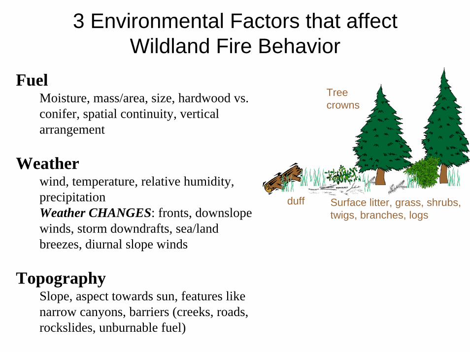
3 Environmental Factors that affect Wildland Fire Behavior
Fuel Moisture, mass/area, size, hardwood vs. conifer, spatial continuity, vertical arrangement
Weather wind, temperature, relative humidity, precipitation Weather CHANGES: fronts, downslopewinds, storm downdrafts, sea/land breezes, diurnal slope winds
TopographySlope, aspect towards sun, features like narrow canyons, barriers (creeks, roads, rockslides, unburnable fuel)
duff Surface litter, grass, shrubs, twigs, branches, logs
Tree crowns

The original (non-DDDAS) application
NCAR’s Coupled Atmosphere – Wildland Fire –Environment model (CAWFE)
FIRE
Atmospheric Dynamics
ATMOSPHEREHeat, water vapor, smoke
Fire Propagation
FIRE ENVIRONMENT
Fuel moisture

Atmospheric ModelSolve prognostic fluid dynamics equations of motion for air momentum, a thermodynamic variable, water vapor and precipitation on a finite difference grid.
• 3-dim., time dependent• Nonhydrostatic, anelastic• Terrain-following coordinates,
vertically stretched grid• 2-way interacting nested
domains• Coarse grain parallelization
• Initialization of atmospheric environment using large-scale gridded weather forecast (RUC, MM5, ETA, etc.)
• Models formation of clouds, rain, and hail in “pyrocumulus” clouds over fires
• Tracks “smoke” dispersion• Aspect-dependent solar heating of
ground

Fire ModelContains components representing:
1. Surface fire– Spread of “flaming front” depends on
wind, fuel, and slope. Based on Rothermel (1972) semi-empirical equations.
– Post-frontal heat/water vapor release
2. Crown fire– If the surface fire produces enough
heat, it heats, dries, and ignites the tree canopy.
3. Heat, water vapor, and smoke fluxes released by fire into atmosphere

Wildland Fire ModelingNCAR’s coupled atmosphere-fire model
simulates the spread of a fire, the impacts of the heat release on atmospheric motions, and the
feedback of fire-induced winds on the fire.
NBig Elk Fire (4400 acres)
Pinewood Springs, CO
17 Jul 2002.
4 hr simulation.
∆x=∆y = ~50 m.
Red: 10 oC buoyancy
White: smoke
Frame each 30 sec.
W
Coen (2005) Intl. J. Wildland Fire

6 nested domains:
10 km, 3.3 km, 1.1 km, 367 m, 122 m, 41 m atm. grid spacing. (Fuel grids much finer.). Timestep in finest domain < 1 sec.
Example: Configured for a research problem
InputsAtmosphere• Initialize atmosphere & provide later
BCs with large-scale weather forecast
Topography• US 3 sec topography
Fuel - Surface and canopy fuels.• Mass/area • Physical characteristics
Fuel moisture
Domain 6
6.7 km
6.7 km

Making it a DDDAS…• Research model -> real-time application• Forecast should be based on all available data:
– fuel maps, airborne images, internet weather data, field data sensor streams, and raw weather station streams
• The modeling paradigm must change.– Initialize & let run -> Assimilation of data -> Assimilation of
out of sequence (delayed) data• Forecast should change quickly when data arrives• The system should provide measurement steering• The system should provide animated visualization
and user steering over the internet

Dynamic Data Driven Application System: Wildfire
Weather data
Fuel map sources (GIS) Weather model
Fire model
Dynamic Data Assimilation
Airborne multispectralimages, satellite fire maps
Surface fire/atm. sensors, telemetryVisualization
SupercomputingCommunication Software engineering

Max Elevation 5,215’Max Grade 20%Average Grade 12%
N
RT 20
RT 63
WASP project
Base map sources• Aerial photos (Nat’l High Alt.)• Gridded orthoquads• SRTM (terrain elevation)• Satellite (Landsat, QuickBird)• WASP (multispectral imaging
camera)• Fuels (AVHRR, GAP)
Data sources• Fire (GeoMAC satellite + sit.
reports/WASP/others)• Terrain (Shuttle Radar Topographic
Mission)• Meteorology - MADIS (surface
meteorology data and fuel moisture) and gridded weather forecasts
• AEDs (Temperature, winds, humidity, radiation, etc. Autonomous Environmental Detectors)
Spatial Data Sources for the Model

D. McKeownB. KremensM. Richardson
Wildfire Airborne Sensor Program (WASP)
Color or Color Infrared Camera• 4k x 4k pixel format• 12 bit quantization• High quality Kodak CCD
High Performance Position Measurement System•Position 5 m•Roll/Pitch 0.03 deg•Heading 0.10 deg
Fire Detection Cameras• 640 x 512 pixel format• 14 bit quantization• < 0.05K NEDT

Time Sequence of Fire PropagationAerial Images from a Prescribed Burn

Image Processing Algorithms(AVIRIS Image from Vodacek et al. and Latham 2002, Int. J. Remote Sensing)
589 nm 770 nm/779 nm
Original image content• Pixel location• Spectral data• Algorithms to register to model grid
• auto extraction of tie points• affine transform
Reduced image content• Normalized Thermal Index?
(MWIR-LWIR)/(MWIR+LWIR)• Fire location• Derived temperatures • Direction fire is spreading• Derived fuels? (NDVI)
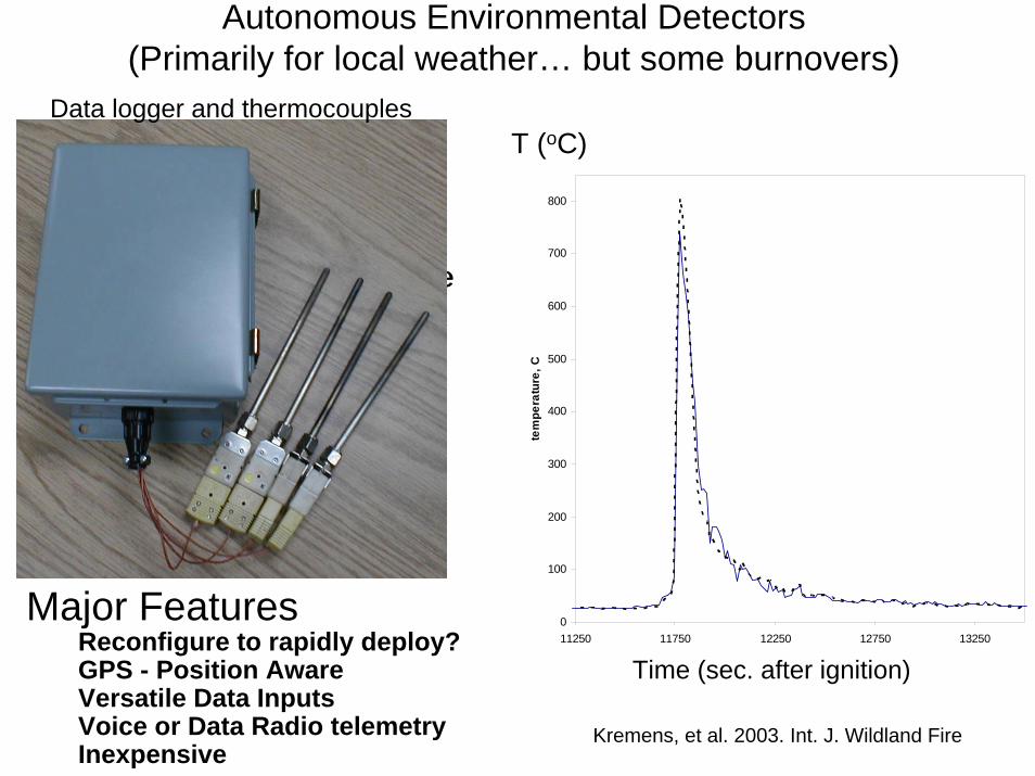
Autonomous Environmental Detectors (Primarily for local weather… but some burnovers)
We have developed a versatile electronic acquisition package ideally suited to field data collection
Major FeaturesReconfigure to rapidly deploy?GPS - Position AwareVersatile Data InputsVoice or Data Radio telemetryInexpensive
Data logger and thermocouples
0
100
200
300
400
500
600
700
800
11250 11750 12250 12750 13250
seconds after ignition
tem
pera
ture
, C
Time (sec. after ignition)
T (oC)
Kremens, et al. 2003. Int. J. Wildland Fire

GeoMAC Fire perimeter datahttp://www.geomac.gov
ArcIMS web application displaying current fire location.
Based on Terra MODIS fire detection products and Incident Management team uploads to Web

The Big PictureENKF 1D fire
Matlab
New fire model Matlab
PDE solv. fireFortran
Base ENKF
DONE
Fire data assimilation
NCAR interface
NCAR atmos. assim, simul. data
Out of order data assimilation
Fire FE interpolation
NCAR atmos+fire assim, simul. data
Fire Image assimilation
Complete dataset from same fire
Atmos. sensor stream assimilation
Input sensor streams
NCAR code in MPIPrototype DDDAS
Input map data (GIS)
Input image data
NCAR DDDAS, stored real data
NCAR DDDAS real-time, MPI
Auto map retrieval
Auto web weather data
Auto image & sensor data
Web visualizationBase fire, param.
est. ENKF
Hidden modelupdate
PROGRESS THINKING TO DOStatus:
Weather data input
NCAR simpleatmos. assim.
PDE Finite element fire model
Parallel ENKF, MPI
Reconcile geo coords model/data
New fire PDE model
Create new hooks to model interface

Research and Education Accomplishments

Method: When a fire ignites…• Gather ignition location/time.• Initialize a 15-km domain coupled atmosphere-
fire model centered on fire location using current large-scale gridded weather forecast, fuel datasets, and fuel moisture.
• Spawn nest finer model domains: 5 km, 1.67 km, and 0.55 km domains.
• Fire ignites in finest domain at observed ignition time/place.
• Fire propagation modeled throughout the 48 hr forecast
Large-scale gridded model forecast
4 nested domains
• Apply NCAR coupled atmosphere-fire model to CO fires as real-time application
• Evaluate strengths/weaknesses of existing model
1. Real-time application of NCAR model on real fires

Dynamic Data Assimilation2. DDDAS Software Structure
Ensemble Filter Module•Adjust ensemble by a Bayesian update
Model Module•Initialize ensemble•Advance ensemble in time•Get observation data•Compare model prediction to observation
Driver Module•Schedule state updates and calls to model functions•Maintain space-time model state = ensemble of simulations
• Each module can be exchanged independently• Simple versions of the modules for R&D and testing, build
complexity gradually• Collaborative cvs repository used by everyone

3. Framework for Assimilating Out of Sequence Data
1. Generate initial ensemble by a random perturbation of initial conditions
2. Repeat the analysis cycle:i. Clone the ensemble at the initial time and advance
the ensembles except the clone to the next time-step
ii. Inject data into all time-steps: modify the ensemble with states at all time-steps as a single big state, by a Bayesian update
Need to maintain (implicitly) an ensemble of time-space state vectors

Assimilating Out of Sequence Data(if we can store all time-steps)
Advance time
Advance time
Bayesian update
Sim
ulat
ion
time
Analysis cycle
Data

4. Data AssimilationThe standard Ensemble Kalman Filter (EnKF)
approach:
• The model state is a probability distribution represented by an ensemble of simulations– Run ensemble of simulations from initial conditions with random
perturbations: how far they spread = uncertainty
• The data probability distribution is represented by the measurement values and the associated error estimates
• The model state is then updated using the Bayes theorem assuming that the probability distributions are approximately normal
• Works well in meteorology and oceanography but fails for assimilation of data about where the fire is

Assumption of normally distributed errors will not work here
• Probability distributions (also of the solution) are too far from Gaussian• The problem is too nonlinear
Probability density
Burns: 70% probability
Does not burn: 30% probability
Least squares solution: does not burn
Ignition temperatureTemperature
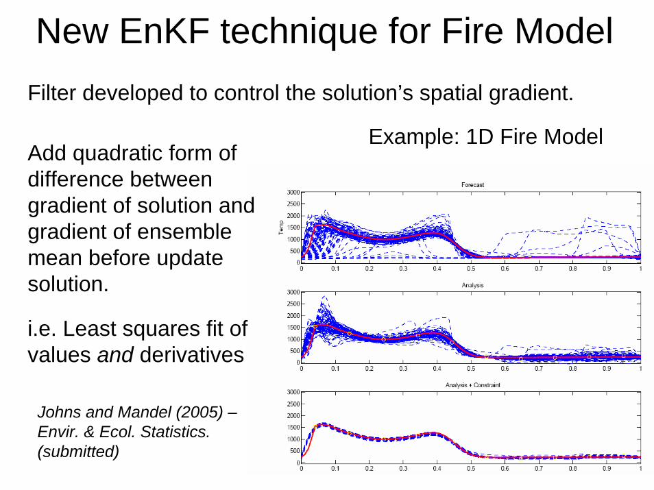
New EnKF technique for Fire ModelFilter developed to control the solution’s spatial gradient.
Example: 1D Fire ModelAdd quadratic form of difference between gradient of solution and gradient of ensemble mean before update solution.
i.e. Least squares fit of values and derivatives
Johns and Mandel (2005) –Envir. & Ecol. Statistics. (submitted)

5. Team Tutorials & Videoconferences• Wildland Fire Modeling• Forecasting and data assimilation• Tutorial on the Ensemble Kalman
Filter• Tutorial on the NCAR atmosphere-
fire model• Tutorial on Particle Filters and
Sequential Monte Carlo • Tutorial on Particle Filters and
Sequential Monte Carlo II• Observation of Fire Propagation in
LWIR• Walk Through the Prototype
Ensemble Kalman Filter Code• Introduction to the Software
Architecture of the NCAR Atmosphere-Fire Model
• Ensemble Kalman Filter (for the 1D fire model)
• An Introduction to Lagrangian and Eulerian Coordinates
• Walkthrough the Coupled Ensemble Kalman - Weather / Fire Code
• Coarse/Fine Mesh Averaging and Demonstration of Model in Real-Time
• Constrained Ensemble Kalman Filter for Data Assimilation in PDE
• Fire Image and Ground Sensor Content and Format
• Code management & Capturing online data• ODE integrators for discontinuous solutions• Code management and software
engineering• The Big Picture, or Who Is Doing What and
Why and When• Current code overview and what the
missing pieces are• Steps to creating synthetic images of
wildland fire• Where did all the cycles go?• Makefiles Primer• Analysis of the wildfire module, adaptation
for DDDAS

Summary• Work in progress• Accomplishments:
– First application of a coupled NWP: fire behavior model in real time
– Software architecture for collaborative development of a complex interdisciplinary, multi-institutional project in place & being used
– Methodology for unique and widely applicable data assimilation techniques developed & being applied to the model application
• out-of-order data arrival• non-Gaussian distributed errors
• Wide education & student participation
http://www-math.cudenver.edu/~jmandel/fires/