tongala - madden maritime summary on 07 may 2015, the marine safety investigation unit (msiu) was...
TRANSCRIPT
Marine Safety Investigation Unit
MARINE SAFETY INVESTIGATION REPORT
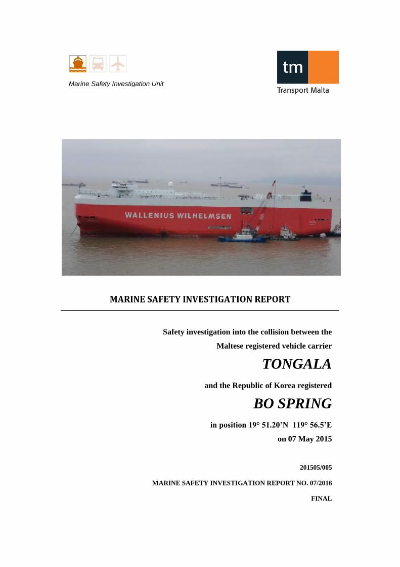
Safety investigation into the collision between the
Maltese registered vehicle carrier
TONGALA
and the Republic of Korea registered
BO SPRING
in position 19° 51.20’N 119° 56.5’E
on 07 May 2015
201505/005
MARINE SAFETY INVESTIGATION REPORT NO. 07/2016
FINAL
ii
Investigations into marine casualties are conducted under the provisions of the Merchant
Shipping (Accident and Incident Safety Investigation) Regulations, 2011 and therefore in
accordance with Regulation XI-I/6 of the International Convention for the Safety of Life at
Sea (SOLAS), and Directive 2009/18/EC of the European Parliament and of the Council of 23
April 2009, establishing the fundamental principles governing the investigation of accidents
in the maritime transport sector and amending Council Directive 1999/35/EC and Directive
2002/59/EC of the European Parliament and of the Council.
This safety investigation report is not written, in terms of content and style, with litigation in
mind and pursuant to Regulation 13(7) of the Merchant Shipping (Accident and Incident
Safety Investigation) Regulations, 2011, shall be inadmissible in any judicial proceedings
whose purpose or one of whose purposes is to attribute or apportion liability or blame, unless,
under prescribed conditions, a Court determines otherwise.
The objective of this safety investigation report is precautionary and seeks to avoid a repeat
occurrence through an understanding of the events of 07 May 2015. Its sole purpose is
confined to the promulgation of safety lessons and therefore may be misleading if used for
other purposes.
The findings of the safety investigation are not binding on any party and the conclusions
reached and recommendations made shall in no case create a presumption of liability
(criminal and/or civil) or blame. It should be therefore noted that the content of this safety
investigation report does not constitute legal advice in any way and should not be construed
as such.
© Copyright TM, 2016.
This document/publication (excluding the logos) may be re-used free of charge in any format
or medium for education purposes. It may be only re-used accurately and not in a misleading
context. The material must be acknowledged as TM copyright.
The document/publication shall be cited and properly referenced. Where the MSIU would
have identified any third party copyright, permission must be obtained from the copyright
holders concerned.
MARINE SAFETY INVESTIGATION UNIT
Malta Transport Centre
Marsa MRS 1917
Malta
iii
CONTENTS
LIST OF REFERENCES AND SOURCES OF INFORMATION .......................................... iv
GLOSSARY OF TERMS AND ABBREVIATIONS ................................................................v
SUMMARY ............................................................................................................................ vii
1 FACTUAL INFORMATION .............................................................................................1 1.1 Vessel, Voyage and Marine Casualty Particulars .......................................................1 1.2 Description of Vessels ................................................................................................2
1.2.1 Tongala ...................................................................................................................2 1.2.2 Crew members on board Tongala ..........................................................................3 1.2.3 Bo Spring ................................................................................................................5
1.3 Location of the Accident and Prevailing Weather Conditions ...................................5 1.4 Narrative .....................................................................................................................6
1.4.1 Events on Tongala ..................................................................................................6 1.4.2 Events on Bo Spring ...............................................................................................9
2 ANALYSIS .......................................................................................................................10 2.1 Purpose .....................................................................................................................10 2.2 Bridge Procedures on Tongala .................................................................................10
2.2.1 The OOW as the sole look-out during hours of daylight ......................................10 2.2.2 Missing barriers on the three ARPA sets ..............................................................11 2.2.3 Keeping a proper lookout by sight and hearing and by all available means ........11
2.3 The Discussion between the Master and the OOW ..................................................13 2.4 The Conduct of the Navigational Watch and Situation Awareness on Tongala ......15 2.5 The Conduct of the Navigational Watch on Bo Spring ............................................20
3 CONCLUSIONS ...............................................................................................................22 3.1 Immediate Safety Factor ...........................................................................................22 3.2 Latent Conditions and other Safety Factors .............................................................22 3.3 Other Findings ..........................................................................................................23
4 ACTIONS TAKEN ...........................................................................................................23 4.1 Safety Actions Taken During the Course of the Safety Investigation ......................23
5 RECOMMENDTIONS .....................................................................................................25
LIST OF ANNEXES ................................................................................................................26

iv
LIST OF REFERENCES AND SOURCES OF INFORMATION
Crew members MV Tongala
Managers MV Tongala
v
GLOSSARY OF TERMS AND ABBREVIATIONS
AIS Automatic Identification System
ARPA Automatic Radar Plotting Aid
BA British Admiralty
BNWAS Bridge Navigational Watch Alarm System
BPM Bridge Procedures Manual
CBT Computer-based training
COG Course over Ground
ColRegs Convention on the International Regulations for Preventing Collisions at
Sea, 1972
CPA Closest Point of Approach
DNV GL Det Norske Veritas Germanischer Lloyd
DWT Deadweight
E East
ECDIS Electronic Chart Display and Information System
(G) Gyro course
GHz Giga Hertz
GPS Global Positioning System
GT Gross Tonnage
Hrs Hours
Iwo In way of
kW Kilowatt
KRS Korean Register of Shipping
LOA Length Overall
LT Local Time
M Metres
MRM Maritime Resource Management
MSIU Marine Safety Investigation Unit
vi
MSM Minimum Safe Manning
MV Motor Vessel
N North
NM Nautical Miles
OOW Navigational Officer of the Watch
RPM Revolutions per Minute
SOG Speed over the Ground
STCW International Convention on Standards of Training, Certification and
Watchkeeping for Seafarers, 1978, as amended
(T) True Course
UAE United Arab Emirates
UTC Universal Time Constant
VDR Voyage Data Recorder
VHF Very High Frequency
vii
SUMMARY
On 07 May 2015, the Marine Safety Investigation Unit (MSIU) was notified by the
managers of MV Tongala, that at about 0730 UTC (07 May 2015 at about 1530 LT),
their vessel was involved in a collision with the Republic of Korea registered general
cargo Bo Spring. The collision happened off the coast of the Philippines, in position
19º 51.2' N 119º 56.5' E. Tongala was on a ballast voyage from Fujairah, United
Arab Emirates (UAE), to Nagoya, Japan.
Preliminary information indicated that the collision occurred when Tongala was
proceeding on a course of 051°(T), while Bo Spring was crossing from the starboard
side on a Northerly course.
As a result of the collision, Tongala sustained structural damages to her starboard
quarter side, above the waterline, in way of (iwo) car decks nos. 3, 5 and 6 and the
engine-room. Tongala sailed under her own power to Zhoushan IMC-Yongyue
Shipyard in China for detailed inspections and repairs. Bo Spring, which sustained
damages to her bow section, also sailed under her own power to Shanghai Minnan
Shipyard in China for repairs.
No injuries and / or marine pollution were reported as a result of this casualty.
The safety investigation concluded that in a typical crossing situation and in good
visibility with vessels in sight of one another for around one hour, both navigational
officers of the watch (OOWs) did not have an accurate situation awareness of the
dynamic context around their respective ships.
One recommendation has been made to the managers of Tongala, to address the use
of off-centre radar displays during navigational watches.
During the course of the safety investigation, the MSIU had very limited information
on Bo Spring, her crew members and the dynamics leading to the collision from the
vessel’s perspective. To this effect, the MSIU was unable to analyse and report on a
more detailed operational context and perhaps enhance the possibility of preventing
similar future accidents by making recommendations to the managers of Bo Spring.

1
1 FACTUAL INFORMATION
1.1 Vessel, Voyage and Marine Casualty Particulars
Name Tongala Bo Spring
Flag Malta Republic of Korea
Classification Society DNV GL KRS
IMO Number 9605786 9109938
Type Vehicle carrier General cargo
Registered Owner Wilhelmsen Lines
Shipowning Malta Ltd
Bobae Shipping Co. Ltd
Managers Wilhelmsen Lines Car
Carriers Ltd
Hanchang Corporation
Ltd
Construction Steel (Double hull) Steel
Length overall 199.99 m 114.11 m
Registered Length 194.13 m 107.8 m
Gross Tonnage 61106 7656
Minimum Safe Manning 15 Unknown
Authorised Cargo Ro-ro (vehicles) Bulk cargo
Port of Departure Fujairah, UAE Unknown
Port of Arrival Nagoya, Japan Unknown
Type of Voyage International Unknown
Cargo Information In ballast Unknown
Manning 25 Unknown
Date and Time 07 May 2015 at 1535 (LT)
Type of Marine Casualty or Incident Serious Marine Casualty
Serious Marine Casualty Serious Marine Casualty
Location of Occurrence 19° 51.20’N 119° 56.50’E
Place on Board Cargo & Tank Areas –
closed deck cargo space
Engine Department –
engine-room
Ship – over side
Ship - forecastle
Injuries/Fatalities None None
Damage/Environmental Impact None None
Ship Operation On passage On passage
Voyage Segment Transit Transit
External & Internal Environment Fresh breeze, calm seas and low swell and good
visibility
Persons on Board 25 Unknown

2
1.2 Description of Vessels
1.2.1 Tongala
The Maltese registered Tongala (Figure 1) is a 61106 gt, vehicle carrier, owned by
Wilhelmsen Lines Shipowning Malta Limited and managed by Wilhelmsen Lines Car
Carriers Ltd of the UK. The vessel was built by MHI Nagasaki Shipyard &
Machinery Works, Japan in 2012 and is classed by Det Norske Veritas Germanischer
Lloyd (DNV GL).
The vessel has a length overall (LOA) of 199.99 m, a moulded breadth of 32.36 m and
a moulded depth of 36.02 m. The vessel has a summer draught of 11.0 m and a
summer deadweight (DWT) of 22585 tonnes. Tongala has a standard car carrier
design, fitted with 12 car decks, capable of taking 6459 vehicles.
Propulsive power is provided by a 7-cylinder Misubishi 7UEC60LSII, two-stroke,
single acting slow speed diesel engine, producing 14315 kW at 105 rpm. This drives
a fixed pitch propeller to give a service speed of about 19.50 knots.
Figure 1: MV Tongala

3
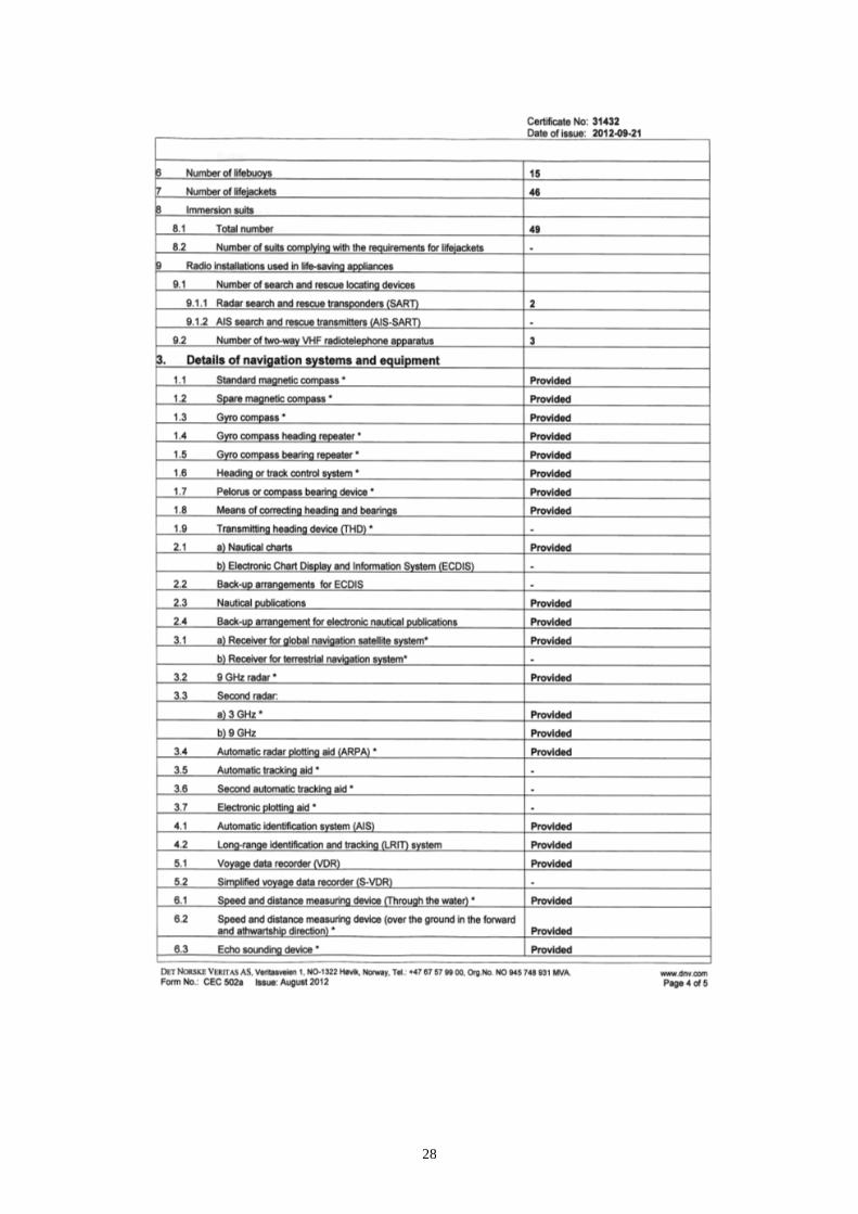
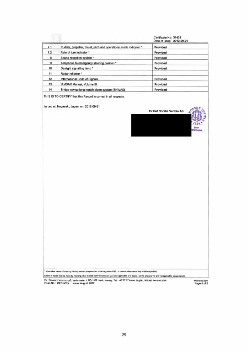
Tongala was equipped with the required navigation equipment as listed on her Record
of Equipment for Cargo Ship Safety Equipment Certificate - Form E (Annex A). The
list included three radars, two X-band and one S-band, all three with Automatic Radar
Plotting Aids (ARPA) facilities. According to the VDR data, the X-band ARPA was
connected to the Global Positioning System (GPS) and the vessel’s course and speed
made good over the ground were also displayed.
The bridge layout was spacious. The chartroom was an integral part of the bridge,
fitted behind the central navigation instrument console (Figure 2). The vessel was
also fitted with an electronic chart display and information system (ECDIS).
Figure 2: Bridge layout, showing position of chartroom and VDR microphones (red)
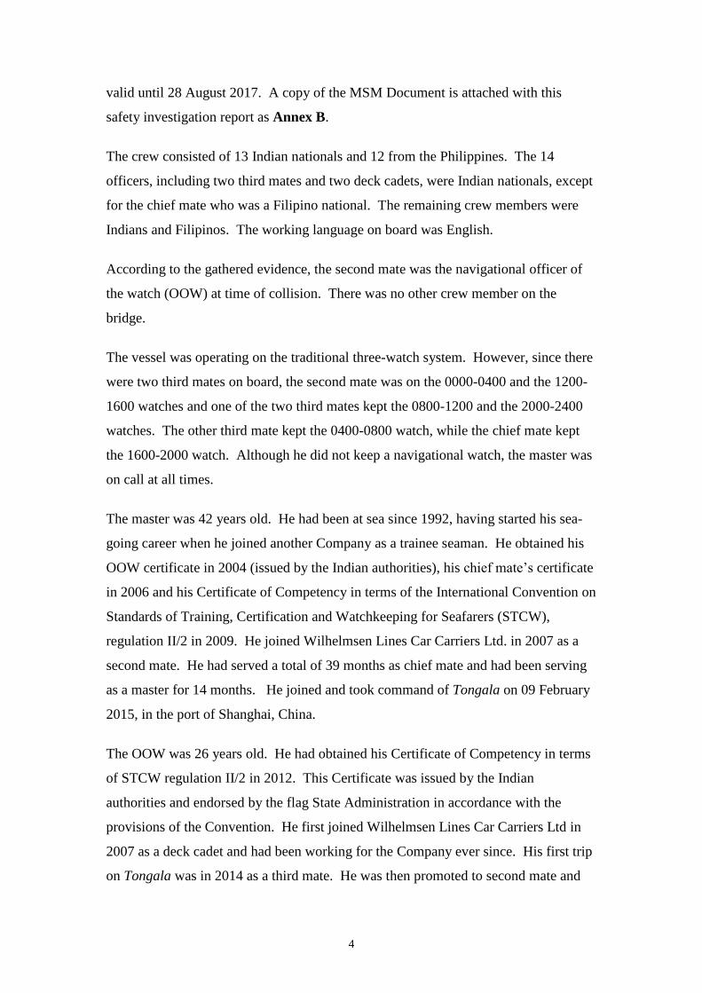
1.2.2 Crew members on board Tongala
At the time of collision, Tongala had a crew of 25 officers and ratings. The crew
compliment was in accordance with, and in excess of the Minimum Safe Manning
(MSM) Document issued by the flag State Administration on 22 March 2014 and
4
valid until 28 August 2017. A copy of the MSM Document is attached with this
safety investigation report as Annex B.
The crew consisted of 13 Indian nationals and 12 from the Philippines. The 14
officers, including two third mates and two deck cadets, were Indian nationals, except
for the chief mate who was a Filipino national. The remaining crew members were
Indians and Filipinos. The working language on board was English.
According to the gathered evidence, the second mate was the navigational officer of
the watch (OOW) at time of collision. There was no other crew member on the
bridge.
The vessel was operating on the traditional three-watch system. However, since there
were two third mates on board, the second mate was on the 0000-0400 and the 1200-
1600 watches and one of the two third mates kept the 0800-1200 and the 2000-2400
watches. The other third mate kept the 0400-0800 watch, while the chief mate kept
the 1600-2000 watch. Although he did not keep a navigational watch, the master was
on call at all times.
The master was 42 years old. He had been at sea since 1992, having started his sea-
going career when he joined another Company as a trainee seaman. He obtained his
OOW certificate in 2004 (issued by the Indian authorities), his chief mate’s certificate
in 2006 and his Certificate of Competency in terms of the International Convention on
Standards of Training, Certification and Watchkeeping for Seafarers (STCW),
regulation II/2 in 2009. He joined Wilhelmsen Lines Car Carriers Ltd. in 2007 as a
second mate. He had served a total of 39 months as chief mate and had been serving
as a master for 14 months. He joined and took command of Tongala on 09 February
2015, in the port of Shanghai, China.
The OOW was 26 years old. He had obtained his Certificate of Competency in terms
of STCW regulation II/2 in 2012. This Certificate was issued by the Indian
authorities and endorsed by the flag State Administration in accordance with the
provisions of the Convention. He first joined Wilhelmsen Lines Car Carriers Ltd in
2007 as a deck cadet and had been working for the Company ever since. His first trip
on Tongala was in 2014 as a third mate. He was then promoted to second mate and
5
had sailed again on Tongala. This was, in fact, his second trip on the vessel, signing
on board in December 2014.
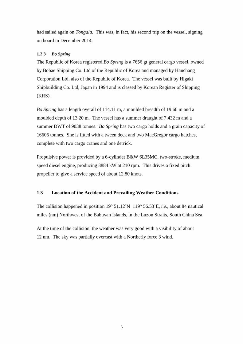
1.2.3 Bo Spring
The Republic of Korea registered Bo Spring is a 7656 gt general cargo vessel, owned
by Bobae Shipping Co. Ltd of the Republic of Korea and managed by Hanchang
Corporation Ltd, also of the Republic of Korea. The vessel was built by Higaki
Shipbuilding Co. Ltd, Japan in 1994 and is classed by Korean Register of Shipping
(KRS).
Bo Spring has a length overall of 114.11 m, a moulded breadth of 19.60 m and a
moulded depth of 13.20 m. The vessel has a summer draught of 7.432 m and a
summer DWT of 9038 tonnes. Bo Spring has two cargo holds and a grain capacity of
16606 tonnes. She is fitted with a tween deck and two MacGregor cargo hatches,
complete with two cargo cranes and one derrick.
Propulsive power is provided by a 6-cylinder B&W 6L35MC, two-stroke, medium
speed diesel engine, producing 3884 kW at 210 rpm. This drives a fixed pitch
propeller to give a service speed of about 12.80 knots.
1.3 Location of the Accident and Prevailing Weather Conditions
The collision happened in position 19° 51.12’N 119° 56.53’E, i.e., about 84 nautical
miles (nm) Northwest of the Babuyan Islands, in the Luzon Straits, South China Sea.
At the time of the collision, the weather was very good with a visibility of about
12 nm. The sky was partially overcast with a Northerly force 3 wind.

6
© Crown Copyright and/or database rights. Reproduced by permission of the Controller of
Her Majesty’s Stationery Office and the UK Hydrographic Office (www.ukho.gov.uk)
Not to be used for
Navigation
1.4 Narrative1
1.4.1 Events on Tongala
After finishing unloading her cargo of cars, Tongala sailed in ballast condition, from
the port of Jebel Ali, United Arab Emirates (UAE) on the 24 April 2015, bound for
Nagoya, Japan via Fujairah, UAE for bunkers.
According to the master and second mate, the vessel followed the prepared passage
plan. Until 07 May 2015, i.e. the day of the casualty, the voyage was uneventful.
On 07 May, Tongala was sailing in the South China Sea, approaching the Luzon
Straits on a course of 048⁰(T) (Figure 2). It was observed that the traffic density was
getting heavier.
Figure 2: Extract from BA Chart 3489, which was in use on 07 May 2015
1 Tongala’s VDR data was in LT and UTC. All entries in the Tongala’s logbook and other
documents were in ship’s time (UTC + 8 hrs). For consistency and ease of comparison with other
information obtained from other sources, all times in the ‘Narrative’ section are in ship's time, with
the occasional reference to the UTC.
7
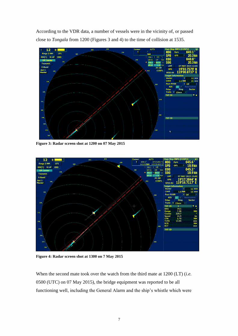
According to the VDR data, a number of vessels were in the vicinity of, or passed
close to Tongala from 1200 (Figures 3 and 4) to the time of collision at 1535.
Figure 3: Radar screen shot at 1200 on 07 May 2015
Figure 4: Radar screen shot at 1300 on 7 May 2015
When the second mate took over the watch from the third mate at 1200 (LT) (i.e.
0500 (UTC) on 07 May 2015), the bridge equipment was reported to be all
functioning well, including the General Alarm and the ship’s whistle which were

8
reportedly tested at 1200. All three radars/ARPA sets and the ECDIS were running
normally.
The starboard X-band and the S-band ARPA radars were both set on North-Up, in
relative motion on the 12 nm range scale with an off-centred display. With this
setting, both radars were scanning approximately 18 nm ahead. The port X-band
ARPA radar was on the six nm range scale, i.e. scanning approximately nine nm
ahead. Evidence suggested that no collision warning alarms were programmed on the
ARPA radar sets. The ECDIS was set to a scale so that a target about 24 nm ahead
could be displayed on the screen2. The vessel’s speed over ground (SOG) was
20.2 knots.
The second mate was the sole look-out on the bridge after he took over the
navigational watch.
At around 1228, the master arrived on the bridge and engaged in a conversation with
the OOW. In his discussion, the master contemplated whether or not to move the
clocks forward by one hour during that evening. He then discussed the chart
corrections3. The master expressed his aim to have the pending chart done prior to his
signing-off. The master also mentioned the other charts which were not part of the
voyage plan. The OOW replied that he would be able to correct these charts as well.
After the master left the bridge at around 1243, the OOW started working on the
passage plan for the next voyage, namely from Singapore to Suez. This required the
preparations of a number of charts.
By 1314, the OOW’s work in the chartroom was well underway. The VDR
recordings indicated that he was intensely immersed in the task, pulling charts out of
the drawers and making the necessary changes to them4. At this time, Tongala had a
vessel on her starboard beam at 1.5 nm and two other targets / vessels, one on the port
side at 11 nm and the other seven nm away on his starboard side. Other vessels came
within Tongala’s radar range, including Bo Spring which was on the radar about one
hour before the collision, i.e., at 1432.
2 The X-band and S-band radars, the ECDIS and the AIS were fully integrated.
3 The second mate was responsible for the chart corrections.
4 Extracts from the VDR data are reproduced in Annex C.

9
The OOW continued with his chart work in the chartroom right up until 1535 when
the collision occurred. Bo Spring struck the starboard side quarter of Tongala, in way
of (iwo) car decks nos. 3, 5 and 6 and the engine-room. When the collision occurred,
the OOW ran around the bridge, picking up the ringing phone and replying ‘I do not
know’ to a question which was made from the other end of the line.
1.4.2 Events on Bo Spring
It has been explained elsewhere in this safety investigation report that the MSIU had
no information on how the dynamics of the events evolved on board Bo Spring.
However, on the basis of the extracts from Tongala’s VDR data, it was clear that
Bo Spring maintained a steady course right up to the collision. No warning signals
were heard from Bo Spring.

10
2 ANALYSIS
2.1 Purpose
The purpose of a marine safety investigation is to determine the circumstances and
safety factors of the accident as a basis for making recommendations, to prevent
further marine casualties or incidents from occurring in the future.
2.2 Bridge Procedures on Tongala
2.2.1 The OOW as the sole look-out during hours of daylight
On the day of the casualty, the OOW was the sole look-out on the bridge. This was in
accordance with the Company’s Bridge Procedures Manual (BPM), Watch Manning
Level 15. It is to be noted that a single look-out during daytime is the norm at sea and
does not contravene international requirements6. However, a number of factors need
to be kept into perspective before deciding on the minimum level of look-outs on the
bridge, mainly:
keeping a proper lookout by sight and hearing at all time7; and
the OOW is not to take any duties which would interfere with the safe
navigation of the ship8.
These factors were also reflected in the Company’s BPM, i.e.: “when the OOW is to
be the lookout during daytime, the OOW understands that he shall not engage in
activity, such as Chart corrections, when he is the sole lookout.”9
Although the number of crew members on Tongala was in excess of the minimum
stipulated by the flag State Administration, the possibility of utilising the extra crew
members when deciding on the watchkeeping arrangements on his vessel10
did not
appear to have been considered. In fact, notwithstanding the workload on the OOW,
5 BPM, section 2 (Bridge Resources Management), sub-section 2.4 – Watch Manning Levels.
6 STCW, regulation VIII/2 and section A-VIII/2.
7 ColRegs rule 5; STCW Code section A-VIII/2, part 4-1 (Principles to be observed in keeping a
navigational watch).
8 STCW, section A-VIII/2, part 4-1 (Principles to be observed in keeping a navigational watch).
9 BPM, sections 2.3.4 and 3.2.4.
10 Tongala had a full complement of deck officers, an extra third mate and two deck cadets.
11
the MSIU did not come across any evidence which indicated that the additional crew
members were being considered to carry out the urgent tasks that distracted the duty
OOW from his navigational watch11
.
2.2.2 Missing barriers on the three ARPA sets
As already explained in sub-section 1.2.1, Tongala was equipped with three ARPA
sets (two 9 GHz and one 3 GHz) and an ECDIS.
It was clear from the VDR audio data that no collision warning alarms were set on
any of the ARPA sets. Furthermore, the Automatic Identification System (AIS) was
not displayed (at least not on the starboard X-band radar), which was interphased with
the VDR.
All three ARPA sets had been set up with an off-centre, displaying a longer range in
the ahead position. However, this mode carries an important disadvantage, i.e. the
reduction in the scanning range on the vessel’s beams and abaft the beams. It is to be
noted that in terms of the ColRegs, a vessel is deemed to be crossing when it
approaches the other vessel from a direction forward of the two points abaft the beam
of the other vessel12
. Hence, in a crossing situation, as it was in this case, the
scanning range on Tongala’s starboard beam and up to two points abaft the starboard
beam was important.
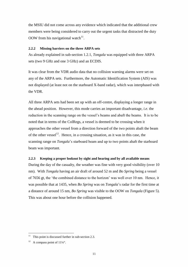
2.2.3 Keeping a proper lookout by sight and hearing and by all available means
During the day of the casualty, the weather was fine with very good visibility (over 10
nm). With Tongala having an air draft of around 52 m and Bo Spring being a vessel
of 7656 gt, the ‘the combined distance to the horizon’ was well over 10 nm. Hence, it
was possible that at 1435, when Bo Spring was on Tongala’s radar for the first time at
a distance of around 15 nm, Bo Spring was visible to the OOW on Tongala (Figure 5).
This was about one hour before the collision happened.
11
This point is discussed further in sub-section 2.3.
12 A compass point of 11¼°.
12
Figure 5: Screen shot at 1435
In the meantime, the OOW had spent long periods of time in the chartroom. Although
the chartroom was not a separate room from the bridge, it was located at the after end
of the bridge (Figure 6). Even with the night curtains drawn open, the sight from the
area was not a clear one especially on the vessel’s beams.
Figure 6: Tongala’s chartroom

13
Furthermore, it seems that the chartroom’s night curtain was normally drawn and
stowed on the starboard side of the railing and hence it would have obstructed the
view of the OOW on the starboard side. Bo Spring was approaching Tongala from
the starboard side, about four points forward of the starboard beam and it is most
likely that the OOW, from his position, would not have visually noticed the
approaching vessel.
Analysis of the VDR data did not indicate that sound signals were heard at any point
in time before the casualty happened. However, it has to be pointed out that with the
bridge being of the fully enclosed type, it was rather difficult to keep a lookout by
hearing; more so with the OOW immersed in his work inside the chartroom.
With the vessel having a fully enclosed bridge, the vessel should have been fitted with
sound reception facilities on the outside so as to have the same effect as if the vessel’s
bridge wing doors were kept open13
. However, according to the VDR audio data, no
sound from the other vessel’s approach was heard inside the bridge right up to the
collision.
Maintaining a navigational watch by all available means, refers also to the appropriate
use of available navigational equipment. Whilst it has already been explained that
there were potential issues with the adopted setting of the ARPA sets (and the ECDIS
alarm because this was not captured on the VDR)14
, the MSIU did not come across
evidence which would have confirmed that long-range scanning was done taking into
consideration that the vessel was making over 20 knots.
2.3 The Discussion between the Master and the OOW
Upon joining Tongala, the master had written his ‘Master’s Special Orders’, which
also incorporated the Company’s BPM and the Standing Instructions. These included,
but were not limited to, the conditions that had to be met when the OOW was the sole
look-out on the bridge. The ‘Master’s Special Orders’ were signed by all the
navigational officers and cadets.
13
Tongala’s BPM, section 3.2.4.1.
14 During the course of the safety investigation, it transpired that the ECDIS alarm volume had been
set at zero.

14
Notwithstanding, the Company’s procedures were not followed in what seemed to be,
a prima facia, a deviation from the Company’s procedures.
Academic studies identify a number of factors which can influence a person’s
decision to deviate from company’s procedures. Of particular interest are two levels,
which have been identified as factors influencing procedural deviation. The two
levels encompass direct motivators and behavioural modifiers. The potential saving
in time and the demonstration of skill to work under pressure (especially after the
master had drawn the attention of the OOW on the charts which required corrections)
were two typical examples of factors influencing procedural variability.
On the other hand, deviations from company’s procedures are highly susceptible to
influences from management. The master was fully aware of the watchkeeping duties
of the OOW. There was no attempt, however, to mitigate the workload by sharing it
amongst other crew members. The MSIU found it possible that no additional crew
members were assigned with the OOW because it was not the intention of the master
to put pressure on the OOW. In fact, during the course of the safety investigation, it
was clarified that the master was willing to simply record the actual correction status
on his handover notes, rather than expecting that these corrections were done prior to
his signing off.
The fact that the OOW gave the matter top priority seemed to be indicative that this
message was not captured (possibly even due to the reasons mentioned above); rather,
it may have inadvertently created an environment which encouraged the OOW to
deviate from Company procedures. Moreover, the hierarchal gap between the master
and the junior OOW may have ‘prohibited’ the latter to ask for additional resources, a
clarification, which would have possibly avoided a misunderstanding.

15
2.4 The Conduct of the Navigational Watch and Situation Awareness on
Tongala
The safety investigation raised several concerns on the conduct of the navigational
watch by the OOW.
The VDR data suggested that as from 1314 onwards, the OOW was engaged in the
chartroom, preparing for the vessel’s next passage plan when at that time there was
another vessel on Tongala’s port beam at a CPA of 1.5 nm (Figure 7).
Figure 7: Screen shot at 1300
Given the multiple tasks which had to be carried out, the OOW decided to utilise the
time of the navigational watch to work in the chartroom. This was a risky decision,
considering that several other ships sailed past Tongala although none came relatively
close to her. Analysis of the radar data revealed that one of these vessels was being
overtaken by Tongala and was almost dead ahead at around 1435 (Figure 8). This
was approximately the same time when Bo Spring first appeared on the radar screen at
a distance of about 15 nm, bearing about four points on the starboard bow. At no time
were any of these vessels/targets acquired by the OOW, at least not on the X-band
radar, which was interphased to the vessel’s VDR.

16
Figure 8: Screen shot at 1435
Further analysis indicated that although the vessel’s course steered was claimed to be
048° (G), according to the VDR data, the vessel’s heading was varying between
046° (G) and 052° (G). However, from 1500 onwards, the vessel’s heading was a
steady 052° (G) indicating that the OOW had adjusted the vessel’s course to
051° (G)15
at that time (Figure 9).
15
The OOW had recalled that the course adjustment was done at around 1515.
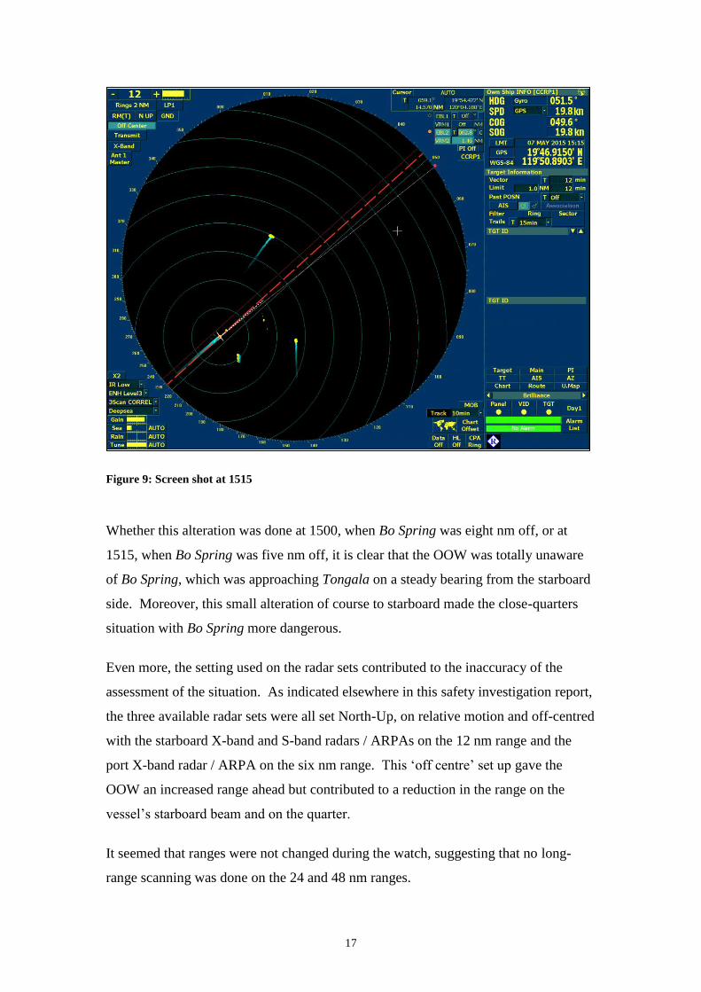
17
Figure 9: Screen shot at 1515
Whether this alteration was done at 1500, when Bo Spring was eight nm off, or at
1515, when Bo Spring was five nm off, it is clear that the OOW was totally unaware
of Bo Spring, which was approaching Tongala on a steady bearing from the starboard
side. Moreover, this small alteration of course to starboard made the close-quarters
situation with Bo Spring more dangerous.
Even more, the setting used on the radar sets contributed to the inaccuracy of the
assessment of the situation. As indicated elsewhere in this safety investigation report,
the three available radar sets were all set North-Up, on relative motion and off-centred
with the starboard X-band and S-band radars / ARPAs on the 12 nm range and the
port X-band radar / ARPA on the six nm range. This ‘off centre’ set up gave the
OOW an increased range ahead but contributed to a reduction in the range on the
vessel’s starboard beam and on the quarter.
It seemed that ranges were not changed during the watch, suggesting that no long-
range scanning was done on the 24 and 48 nm ranges.
18
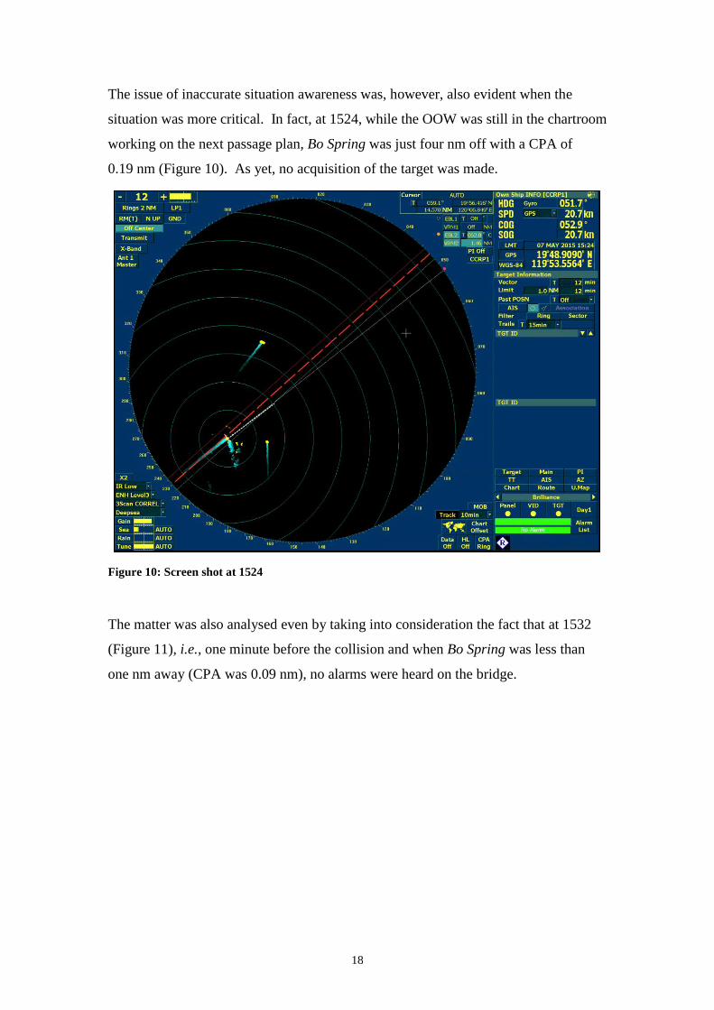
The issue of inaccurate situation awareness was, however, also evident when the
situation was more critical. In fact, at 1524, while the OOW was still in the chartroom
working on the next passage plan, Bo Spring was just four nm off with a CPA of
0.19 nm (Figure 10). As yet, no acquisition of the target was made.
Figure 10: Screen shot at 1524
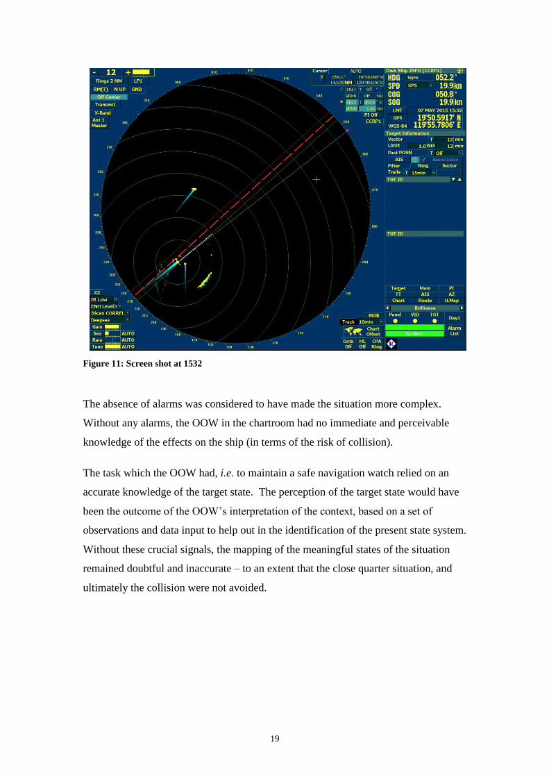
The matter was also analysed even by taking into consideration the fact that at 1532
(Figure 11), i.e., one minute before the collision and when Bo Spring was less than
one nm away (CPA was 0.09 nm), no alarms were heard on the bridge.
19
Figure 11: Screen shot at 1532
The absence of alarms was considered to have made the situation more complex.
Without any alarms, the OOW in the chartroom had no immediate and perceivable
knowledge of the effects on the ship (in terms of the risk of collision).
The task which the OOW had, i.e. to maintain a safe navigation watch relied on an
accurate knowledge of the target state. The perception of the target state would have
been the outcome of the OOW’s interpretation of the context, based on a set of
observations and data input to help out in the identification of the present state system.
Without these crucial signals, the mapping of the meaningful states of the situation
remained doubtful and inaccurate – to an extent that the close quarter situation, and
ultimately the collision were not avoided.

20
2.5 The Conduct of the Navigational Watch on Bo Spring
The MSIU was extremely restricted in its analysis of the events happening on board
Bo Spring due to the lack of data.
However, as already pointed out above, the two vessels should have been in sight of
one another when they were at least 12 nm apart, i.e., about 45 minutes prior to the
collision. The fact that Bo Spring had Tongala on her port side, made
Bo Spring the ‘Stand On’ vessel, and hence was required to maintain her course and
speed.
It was clear from Tongala’s VDR and ECDIS data that Bo Spring neither sounded any
warning signals nor did it take any action to avoid a collision in accordance with the
relevant regulations. This raised doubts on the effectiveness of the lookout by the
OOW on Bo Spring.
21
THE FOLLOWING CONCLUSIONS, SAFETY
ACTIONS AND RECOMMENDATION SHALL IN NO
CASE CREATE A PRESUMPTION OF BLAME OR
LIABILITY. NEITHER ARE THEY BINDING NOR
LISTED IN ANY ORDER OF PRIORITY.

22
3 CONCLUSIONS
Findings and safety factors are not listed in any order of priority.
3.1 Immediate Safety Factor
.1 The immediate cause of the collision was an inaccurate awareness of the
situation on both vessels.
3.2 Latent Conditions and other Safety Factors
.1 Irrespective of the workload on the OOW, the MSIU did not come across any
evidence which indicated that the additional crew members were being
considered to carry out the tasks that distracted the duty OOW from his
navigational watch.
.2 No collision warning alarms were set on any of the ARPA sets.
.3 The ECDIS alarm was not effective to draw the attention of the OOW.
.4 The OOW had spent long periods of time in the chartroom.
.5 The chartroom’s night curtain was normally kept drawn and stowed on the
starboard side of the railing and hence it would have obstructed the view of the
OOW on the starboard side.
.6 The potential saving in time and the demonstration of skill to work under
pressure were two typical examples of factors influencing procedural
variability by the OOW.
.7 The hierarchy gap between the master and the junior OOW may have
‘prohibited’ the latter to ask for additional resources.
.8 Given the multiple tasks which had to be carried out, the OOW decided to
utilise the time of the navigational watch to work in the chartroom.
.9 The OOW inside the chartroom missed on crucial signals, leading to a
doubtful and inaccurate mapping of the meaningful states of the situation.
.10 It was clear from Tongala’s VDR and ECDIS data that Bo Spring neither
sounded any warning signals nor did it take any action to avoid the collision.
23
3.3 Other Findings
.1 All three ARPA sets had been set up with an off-centre, displaying a longer
range in the ahead position but with a reduction in the scanning range on the
vessel’s beams and abaft the beams.
.2 It seemed that ranges were not changed during the watch, suggesting that no
long-range scanning was done on the 24 and 48 nm ranges.
4 ACTIONS TAKEN
4.1 Safety Actions Taken During the Course of the Safety Investigation
Following the accident, Wilhelmsen Lines Car Carriers Ltd. took the following
actions:
Maritime Resource Management (MRM) Training – The criteria for specific
training in MRM has been enhanced to include a requirement for the training to
be carried out every five years for masters, chief mates, second and third
officers, chief and second engineers, and electricians. Previously, there had
been no requirement for MRM refresher courses;
Voyage Data Recorder data as a training aid – A review of technical capability
has been carried out and the Company has decided to improve the interface
functionality of the VDR units in order to allow downloads of targeted periods
of time to be extracted. The primary scope is to have a valuable training aid by
allowing the shipboard management team to review navigational practices on
board. In addition, improvements in the Company’s incident management
processes are anticipated as a result of better access to VDR data for analysis.
The Company has advised that this upgrade is taking place as part of a broader,
fleet-wide project presently underway to improve the ECDIS provision;
Masters’ random checks of navigational watchkeeping practices – Following
the accident, serving masters were instructed to carry out random checks on
watchkeeping standards on board their vessels (including equipment alarm
setting status) and to review and amend their respective Standing Orders if any
deficiencies were noted. The Company has requested that this routine is
24
adopted as part of a three monthly process within the vessels’ planned
maintenance system,
Removal of the Bridge Navigational Watch Alarm System (BNWAS) reset
function – The facility to reset the BNWAS alarm function at the chart table is
being removed on all Company vessels. The Company has advised that this
action is designed to discourage OOWs from adopting poor watchkeeping
practices;
Computer-based training (CBT) training in ColRegs application – A review of
the CBT records has been carried out to ensure that the Company specified
ColRegs training has been completed by the required individuals, and
deficiencies addressed as necessary;
Additional promotion criteria – In order to facilitate the better appraisal of all
shipboard personnel, the Company is considering a ‘Crew Training Record
Book’. The Book will record task achievement and hence competence
standards, as an individual progresses along his/her career path. The Company
believes that it will provide objective evidence which will allow serving masters
to better assess the comparative competence and experience levels of their
officers and crew;
Training Presentations and Experience Feedback – Training presentations have
been given at bi-annual officers’ conferences in India and the Philippines to
discuss the accident in detail. The presentations included the results of the root
cause analysis, lessons learned and actions to prevent recurrence. These
presentations have been supplemented by Global Experience Feedback
summaries, which have been distributed fleet-wide;
Company’s BPM and Navigational Watchkeeping – The Company is amending
its BPM to strictly prohibit a navigational OOW from carrying out tasks not
related to a safe navigational watch (inter alia, chart corrections, voyage
planning, routine testing and maintenance of equipment) when he/she is the sole
look-out on the bridge.
25
5 RECOMMENDATIONS
In view of the conclusions reached and taking into consideration the safety actions
taken during the course of the safety investigation,
Wilhelmsen Lines Car Carriers Ltd. is recommended to:
07/2016_R1 to inform crew members of the limitations in the use of using
radar/ARPA sets with an off-centred display when this may affect the accuracy
of situation awareness.

26
LIST OF ANNEXES
Annex A Tongala’s Cargo Ship Safety Equipment Certificate - Form E (Record
of Equipment)
Annex B Minimum Safe Manning Certificate
Annex C Extracts from the VDR Data

27
Annex A Tongala’s Cargo Ship Safety Equipment Certificate - Form E (Record
of Equipment)
28
29

30
Annex B Minimum Safe Manning Certificate

31
Annex C Extracts from the VDR Data
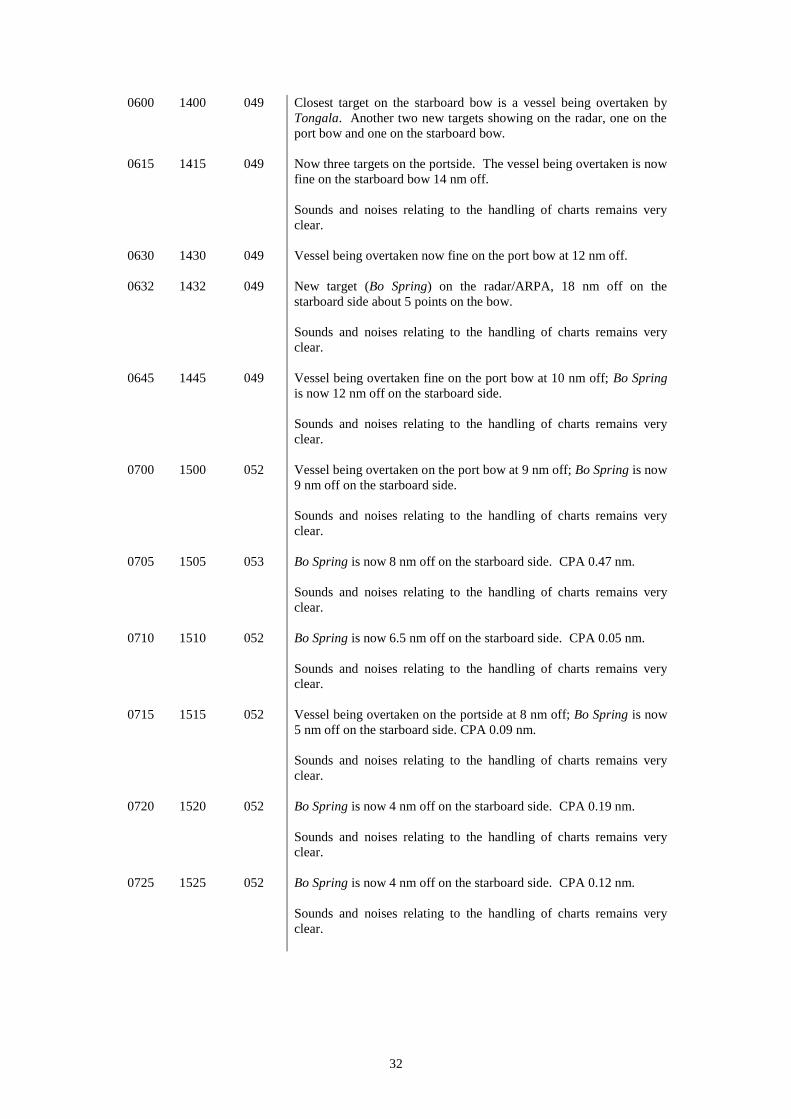
UTC LT Co (T) Action / Transcript
0400 1200 048 Tongala Noon Position: 19° 04’ N 119° 01’ E; Speed 20.3 Knots;
Conversation and laughter can be heard between the third mate and
the Second mate on the Bridge as part of the handover of the watch.
The General/Fire Alarm and the Fog Horn were sounded/tested. The
X-band Radar/ARPA JMA-922B-9XA was on North Up, off-centred
at 12 nm range.
Two vessels/targets coming down on the starboard side.
0409 1209 048 Third mate left the Bridge. Noise/calls heard on the VHF radio.
0420 1220 048 Tongala’s speed 20.9 Knots. VHF active again.
0427 1227 048 Master arrives on the Bridge. Conversation between the Master and
the second mate on whether or not to move forward the ship’s clocks
by one hour that evening and about the chart corrections which the
Second mate was asked to bring up to date as the master was
preparing his hand-over report.
0437 1237 048 One target/vessel on the radar, fine on the port bow, 19 nm away.
0438 1238 048 Target acquired: other vessel’s speed 11 knots, Course 236° and CPA
2.6 nm but no name of the vessel.
0445 1245 046.5 Master left the bridge.
0450 1250 046 Another target/vessel on the radar 18 nm away on the starboard bow.
0500 1300 046 Own speed 19 knots. Other vessels/targets: on the port bow Course
230°, Speed 11.5 knots;, CPA 1.70 nm; another target on the port
side, 18 nm away.
0514 1314 046 Target/vessel on the port beam, CPA 1.5 nm. While the other target
on the port side at 11 nm away and the one on the starboard side at
seven nm away.
Clear sounds and noises can be heard relating to the handling of
charts, opening and closing of chart drawers and the erasing of
previous courses/cleaning of charts.
0516 1316 046 Closest target now abaft the beam. No other targets on the
radar/ARPA had been acquired.
Sounds/noises relating to the handling of charts continues.
0519 1319 046 Target on the port bow now 8 nm off. VHF radio very active.
Sounds/noises relating to the handling of charts very clear.
0535 1335 052 Own course now 052°(G).
0540 1340 051 New target on the starboard bow 19 nm off.
32
0600 1400 049 Closest target on the starboard bow is a vessel being overtaken by
Tongala. Another two new targets showing on the radar, one on the
port bow and one on the starboard bow.
0615 1415 049 Now three targets on the portside. The vessel being overtaken is now
fine on the starboard bow 14 nm off.
Sounds and noises relating to the handling of charts remains very
clear.
0630 1430 049 Vessel being overtaken now fine on the port bow at 12 nm off.
0632 1432 049 New target (Bo Spring) on the radar/ARPA, 18 nm off on the
starboard side about 5 points on the bow.
Sounds and noises relating to the handling of charts remains very
clear.
0645 1445 049 Vessel being overtaken fine on the port bow at 10 nm off; Bo Spring
is now 12 nm off on the starboard side.
Sounds and noises relating to the handling of charts remains very
clear.
0700 1500 052 Vessel being overtaken on the port bow at 9 nm off; Bo Spring is now
9 nm off on the starboard side.
Sounds and noises relating to the handling of charts remains very
clear.
0705 1505 053 Bo Spring is now 8 nm off on the starboard side. CPA 0.47 nm.
Sounds and noises relating to the handling of charts remains very
clear.
0710 1510 052 Bo Spring is now 6.5 nm off on the starboard side. CPA 0.05 nm.
Sounds and noises relating to the handling of charts remains very
clear.
0715 1515 052 Vessel being overtaken on the portside at 8 nm off; Bo Spring is now
5 nm off on the starboard side. CPA 0.09 nm.
Sounds and noises relating to the handling of charts remains very
clear.
0720 1520 052 Bo Spring is now 4 nm off on the starboard side. CPA 0.19 nm.
Sounds and noises relating to the handling of charts remains very
clear.
0725 1525 052 Bo Spring is now 4 nm off on the starboard side. CPA 0.12 nm.
Sounds and noises relating to the handling of charts remains very
clear.

33
0730 1530 052 Bo Spring is now 1.5 nm off on the starboard side. VHF radio active
but the call is not clear enough to understand
Sounds and noises relating to the handling of charts remains very
clear.
0732 1532 052 Bo Spring is now less than one nm off. CPA 0.09 nm.
Sounds and noises relating to the handling of charts remains very
clear.
0735 1535 052 Position: 19°51.1’N 119° 56.5’E; collision/crushing noise can be
heard; immediately the bridge telephone rings, and the second mate
answered “I do not know.”
NB: It is to be noted that the while the conversations and noises/sounds in the chartroom were very clear on the
VDR voice recordings, the VHF calls were not. Conversations which took place on the bridge in the Indian
language were translated to the English language by the managers.