tokyo university of marine science and technology t. takasu, t. ebinuma and a. yasuda 2009...
TRANSCRIPT
Tokyo University of Marine Science and Technology
T. Takasu, T. Ebinuma and A. Yasuda
2009 International Symposium on GPS/GNSS
Effect of Quasi Zenith Satellite (QZS) on GPS Positioning
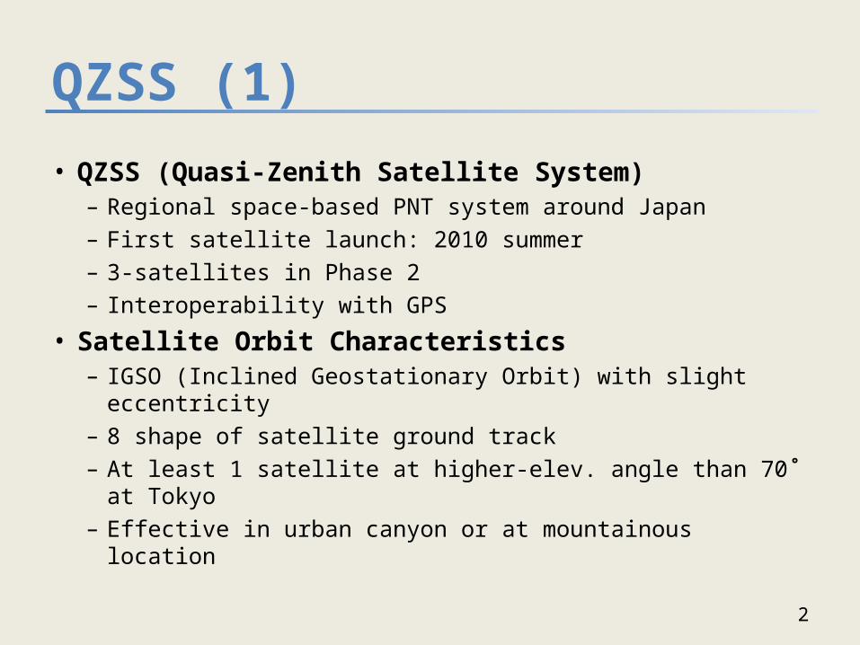
QZSS (1)
• QZSS (Quasi-Zenith Satellite System)– Regional space-based PNT system around Japan– First satellite launch: 2010 summer– 3-satellites in Phase 2– Interoperability with GPS
• Satellite Orbit Characteristics– IGSO (Inclined Geostationary Orbit) with slight eccentricity– 8 shape of satellite ground track– At least 1 satellite at higher-elev. angle than 70˚ at Tokyo– Effective in urban canyon or at mountainous location
2
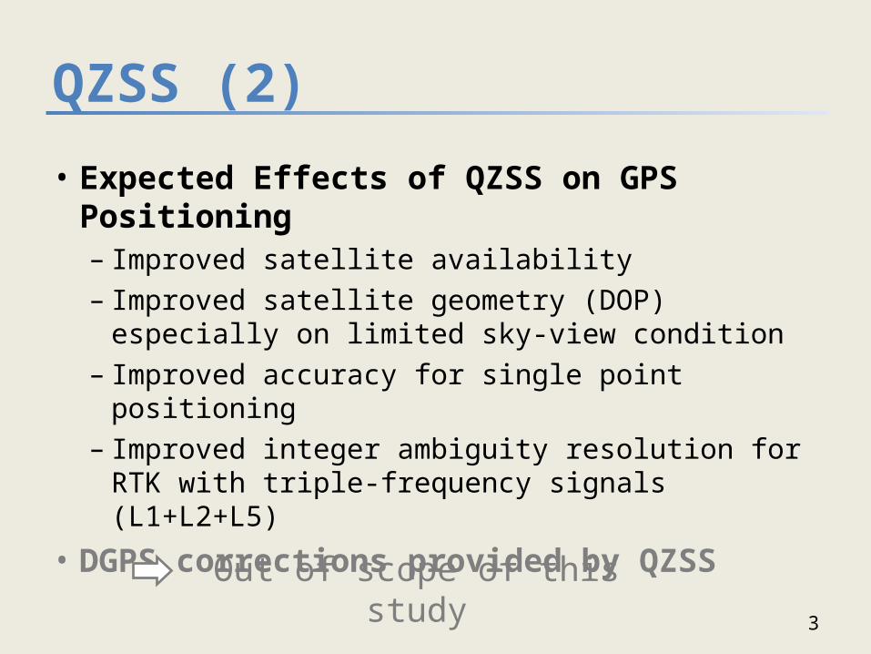
QZSS (2)
• Expected Effects of QZSS on GPS Positioning– Improved satellite availability– Improved satellite geometry (DOP) especially on
limited sky-view condition– Improved accuracy for single point positioning– Improved integer ambiguity resolution for RTK
with triple-frequency signals (L1+L2+L5)
• DGPS corrections provided by QZSS
3
Out of scope of this study

Satellite Constellation
4
Sat OrbitOrbit Element
a(km) e i
(˚)Center Long.
QZS1 IGSO 42164 0.075 43.0 130˚E
QZS2 IGSO 42164 0.075 43.0 135˚E
QZS3 IGSO 42164 0.075 43.0 140˚E
QZS4 GEO 42164 0.0 0.0 78˚E
QZS5 GEO 42164 0.0 0.0 116˚E
QZS6 GEO 42164 0.0 0.0 154˚E
QZS7 GEO 42164 0.0 0.0 168˚W
Ground Tracks
• 3 QZSs: 3 IGSO• 7 QZSs: 3 IGSO + 4 GEO (Future Enhancement)
Orbit Elements
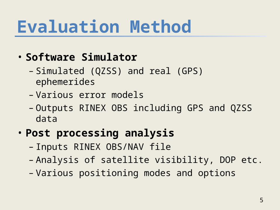
Evaluation Method
• Software Simulator– Simulated (QZSS) and real (GPS) ephemerides– Various error models– Outputs RINEX OBS including GPS and QZSS data
• Post processing analysis– Inputs RINEX OBS/NAV file– Analysis of satellite visibility, DOP etc. – Various positioning modes and options
5
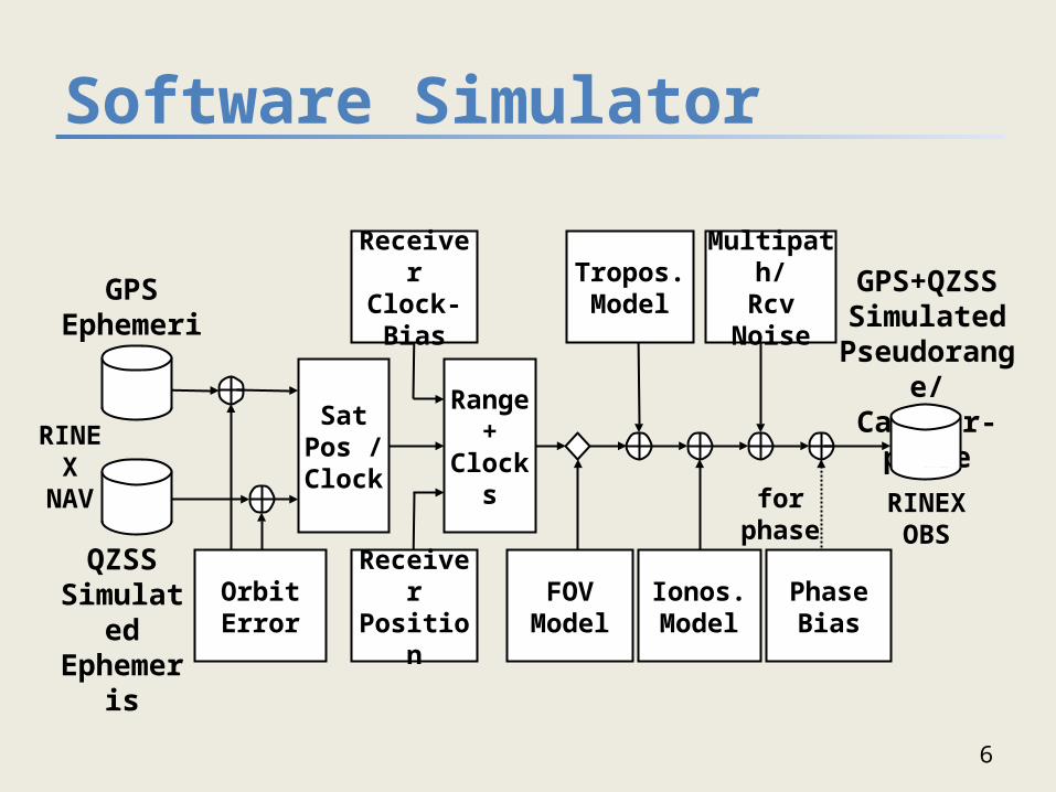
Software Simulator
6
Sat Pos
/Clock
Range+ Clocks
GPS+QZSSSimulated
Pseudorange/Carrier-phase
Tropos.Model
Multipath/Rcv Noise
Receiver Clock-Bias
QZSS Simulated Ephemeris
GPS Ephemeris
RINEXNAV
RINEXOBS
for phase
Receiver Position
FOVModel
Ionos.Model
PhaseBias
OrbitError
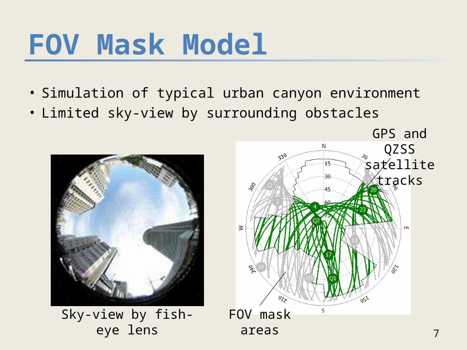
FOV Mask Model
7
• Simulation of typical urban canyon environment• Limited sky-view by surrounding obstacles
Sky-view by fish-eye lens
GPS and QZSS satellite tracks
FOV mask areas

Post Processing Analysis
• RTKLIB ver. 2.3.0b– Analysis of solution availability and DOP– Single point positioning– Carrier-based relative positioning to simulate RTK– Enhancement to support QZSS RINEX OBS/NAV
8
GPS+QZSSRINEX NAV/OBS
SoftwareSimulator RTKPLOTRTKPOST
SolutionFile
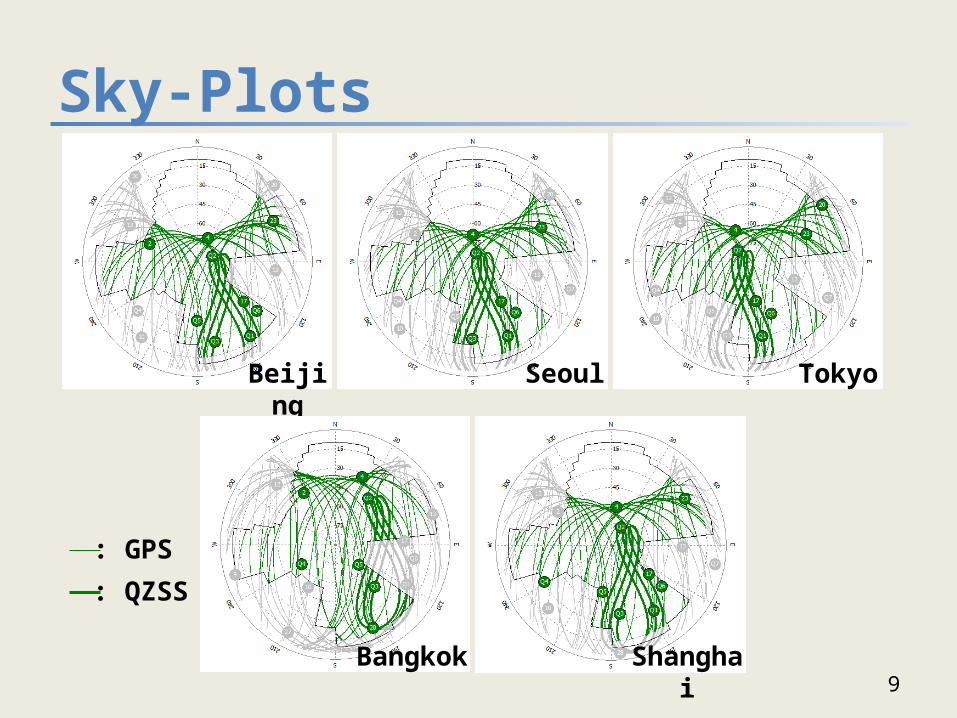
Sky-Plots
9
Beijing Seoul Tokyo
ShanghaiBangkok
: GPS
: QZSS
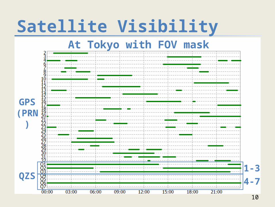
Satellite Visibility
10
QZS1-34-7
GPS(PRN)
At Tokyo with FOV mask
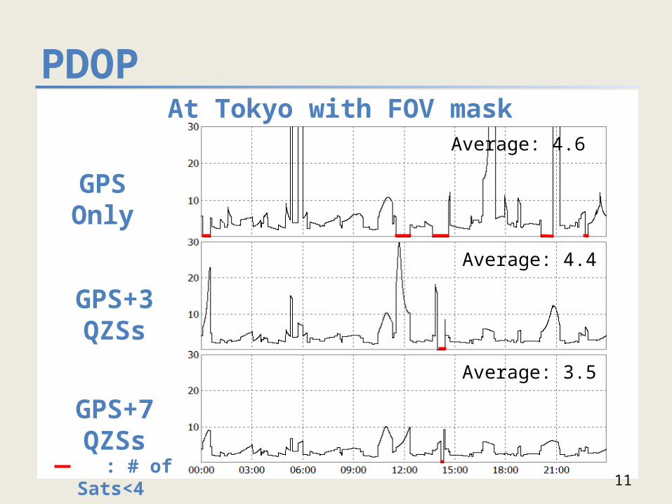
PDOP
11
GPS Only
Average: 3.5
Average: 4.4
Average: 4.6
: # of Sats<4
GPS+3 QZSs
GPS+7 QZSs
At Tokyo with FOV mask
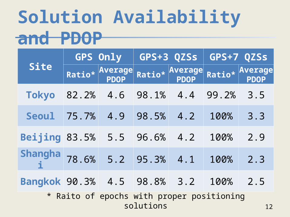
Solution Availability and PDOP
12
SiteGPS Only GPS+3 QZSs GPS+7 QZSs
Ratio* Average PDOP Ratio* Average
PDOP Ratio* Average PDOP
Tokyo 82.2% 4.6 98.1% 4.4 99.2% 3.5
Seoul 75.7% 4.9 98.5% 4.2 100% 3.3
Beijing 83.5% 5.5 96.6% 4.2 100% 2.9
Shanghai 78.6% 5.2 95.3% 4.1 100% 2.3
Bangkok 90.3% 4.5 98.8% 3.2 100% 2.5
* Raito of epochs with proper positioning solutions
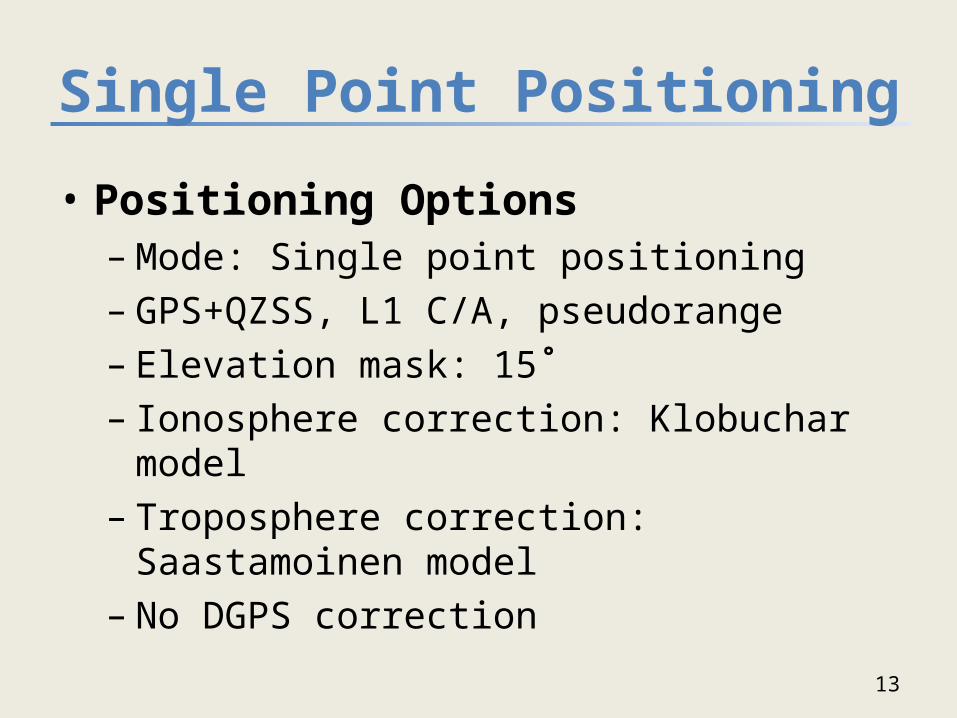
Single Point Positioning
• Positioning Options– Mode: Single point positioning– GPS+QZSS, L1 C/A, pseudorange– Elevation mask: 15˚– Ionosphere correction: Klobuchar model– Troposphere correction: Saastamoinen model– No DGPS correction
13
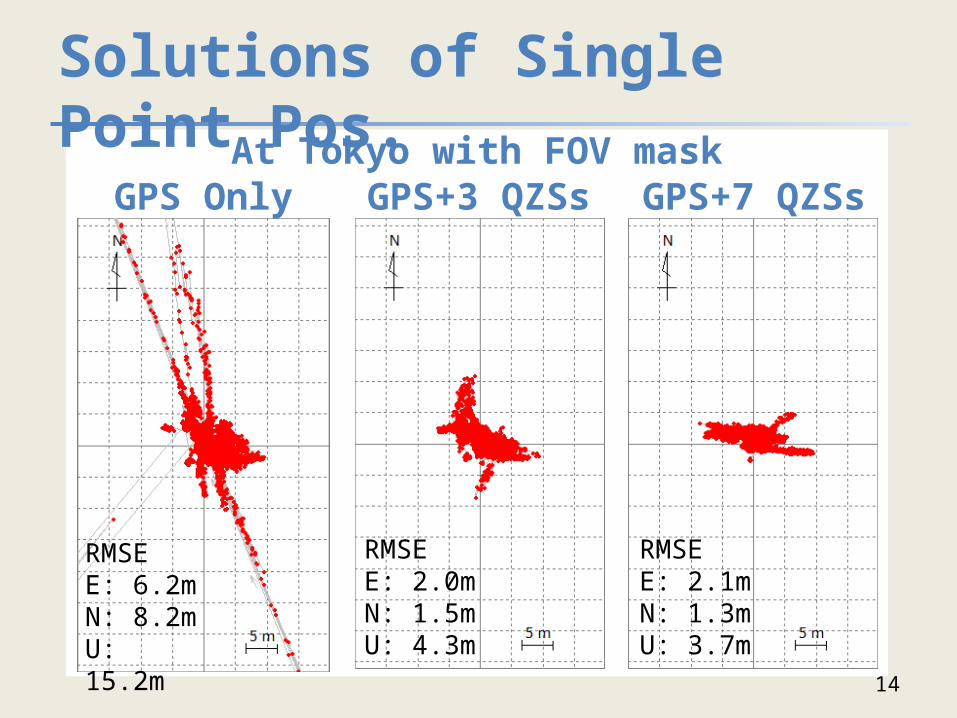
Solutions of Single Point Pos.
14
GPS Only GPS+3 QZSs GPS+7 QZSsAt Tokyo with FOV mask
RMSEE: 6.2mN: 8.2mU: 15.2m
RMSEE: 2.0mN: 1.5mU: 4.3m
RMSEE: 2.1mN: 1.3mU: 3.7m
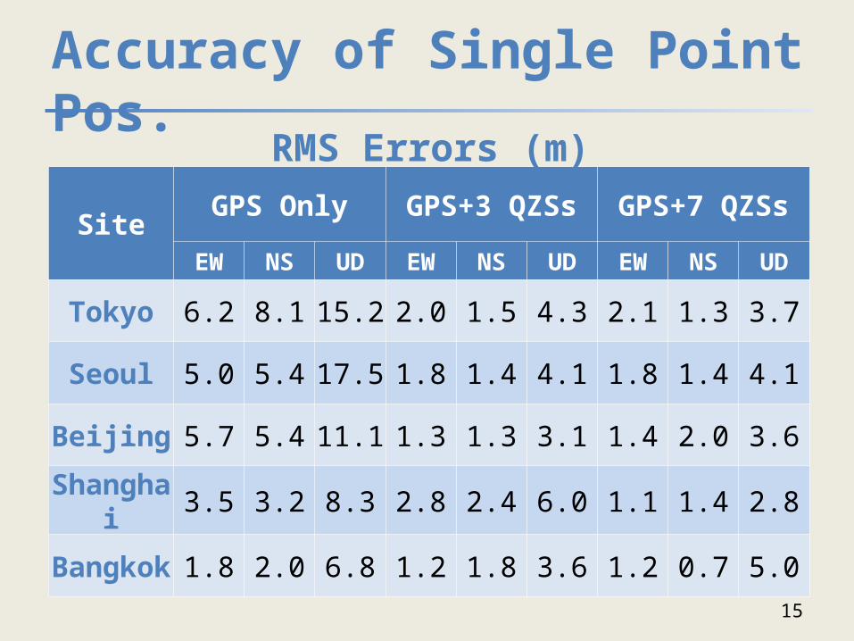
Accuracy of Single Point Pos.
15
SiteGPS Only GPS+3 QZSs GPS+7 QZSs
EW NS UD EW NS UD EW NS UD
Tokyo 6.2 8.1 15.2 2.0 1.5 4.3 2.1 1.3 3.7
Seoul 5.0 5.4 17.5 1.8 1.4 4.1 1.8 1.4 4.1
Beijing 5.7 5.4 11.1 1.3 1.3 3.1 1.4 2.0 3.6
Shanghai 3.5 3.2 8.3 2.8 2.4 6.0 1.1 1.4 2.8
Bangkok 1.8 2.0 6.8 1.2 1.8 3.6 1.2 0.7 5.0
RMS Errors (m)
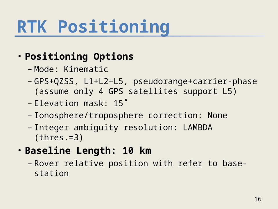
RTK Positioning
• Positioning Options– Mode: Kinematic– GPS+QZSS, L1+L2+L5, pseudorange+carrier-phase
(assume only 4 GPS satellites support L5)– Elevation mask: 15˚– Ionosphere/troposphere correction: None– Integer ambiguity resolution: LAMBDA (thres.=3)
• Baseline Length: 10 km– Rover relative position with refer to base-station
16
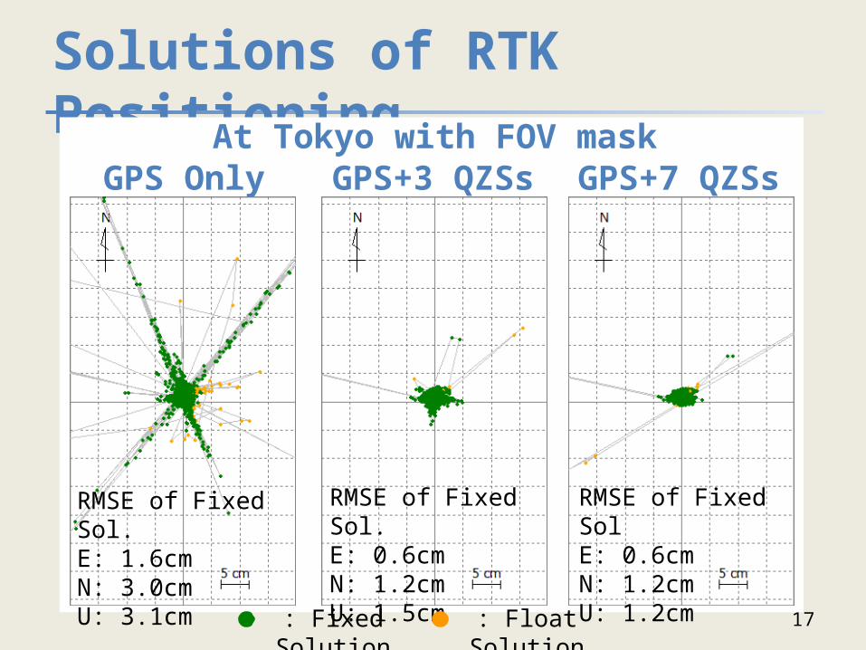
Solutions of RTK Positioning
17
GPS Only GPS+3 QZSs GPS+7 QZSsAt Tokyo with FOV mask
RMSE of Fixed Sol.E: 1.6cmN: 3.0cmU: 3.1cm
RMSE of Fixed Sol.E: 0.6cmN: 1.2cmU: 1.5cm
RMSE of Fixed SolE: 0.6cmN: 1.2cmU: 1.2cm
: Fixed Solution : Float Solution
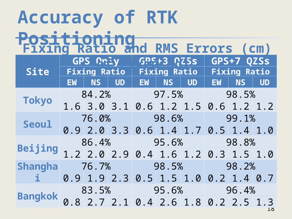
Accuracy of RTK Positioning
18
SiteGPS Only GPS+3 QZSs GPS+7 QZSsFixing Ratio Fixing Ratio Fixing Ratio
EW NS UD EW NS UD EW NS UD
Tokyo 84.2% 97.5% 98.5%1.6 3.0 3.1 0.6 1.2 1.5 0.6 1.2 1.2
Seoul 76.0% 98.6% 99.1%0.9 2.0 3.3 0.6 1.4 1.7 0.5 1.4 1.0
Beijing 86.4% 95.6% 98.8%1.2 2.0 2.9 0.4 1.6 1.2 0.3 1.5 1.0
Shanghai 76.7% 98.5% 98.2%0.9 1.9 2.3 0.5 1.5 1.0 0.2 1.4 0.7
Bangkok 83.5% 95.6% 96.4%0.8 2.7 2.1 0.4 2.6 1.8 0.2 2.5 1.3
Fixing Ratio and RMS Errors (cm) of Fixed Sol.
Conclusions
• Evaluation of the effects of QZSS on GPS positioning– More than 95% of solution availability with QZSS even on
limited sky-view condition– More accurate single point solution primary due to DOP
improvement with QZSS – More than 90% of fixing ratio is expected for RTK with
QZSS and triple-frequency signals
• QZSS combined with GPS will much enhance the positioning performance especially in sever environment like urban canyon.
19
20
Appendix
21
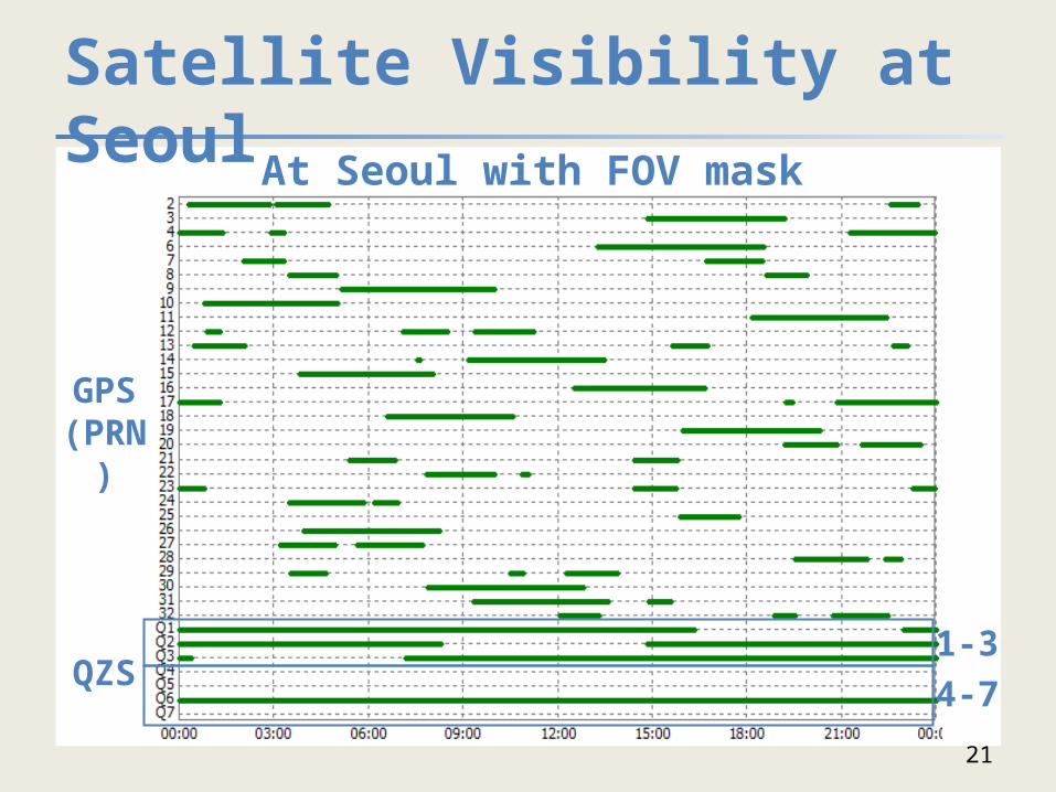
QZS1-34-7
GPS(PRN)
At Seoul with FOV maskSatellite Visibility at Seoul
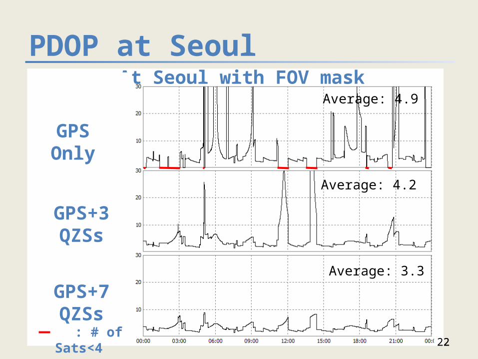
PDOP at Seoul
2222
Average: 3.5
Average: 4.4
Average: 4.6
At Seoul with FOV mask
GPS Only
: # of Sats<4
GPS+3 QZSs
GPS+7 QZSs
Average: 4.9
Average: 4.2
Average: 3.3