to cite this publication - world bank innovation and ... · 3.0 data issues ... data flow diagram...
TRANSCRIPT

1

2

iii
© 2011 The International Bank for Reconstruction and Development / The World Bank
1818 H Street NW
Washington DC 20433
Telephone: 202-473-1000
Internet: www.worldbank.org
E-mail: [email protected]
All rights reserved
The findings, interpretations and conclusions expressed herein are entirely those of the author(s) and do not necessarily
reflect the view of infoDev, the Donors of infoDev, the International Bank for Reconstruction and Development/The World
Bank and its affiliated organizations, the Board of Executive Directors of the World Bank or the governments they
represent. The World Bank cannot guarantee the accuracy of the data included in this work. The boundaries, colors,
denominations, and other information shown on any map in this work do not imply on the part of the World Bank any
judgment of the legal status of any territory or the endorsement or acceptance of such boundaries.
Rights and Permissions
The material in this publication is copyrighted. Copying and/or transmitting portions or all of this work without permission
may be a violation of applicable law. The International Bank for Reconstruction and Development/The World Bank
encourages dissemination of its work and will normally grant permission to reproduce portions of the work promptly.
For permission to photocopy or reprint any part of this work, please send a request with complete information to infoDev
Communications & Publications Department; 2121 Pennsylvania Avenue, NW; Mailstop F 5P-503, Washington, D.C. 20433,
USA; telephone 202-458-4070; Internet: www.infodev.org; E-mail: [email protected].
All other queries on rights and licenses, including subsidiary rights, should be addressed to the Office of the Publisher, The
World Bank, 1818 H Street NW, Washington, D.C. 20433, USA; fax: 202-522-2422; e-mail: [email protected].
Cover design by infoDev
To cite this publication: GIC/ESRI Canada (2011). Feasibility Study for a National Spatial Data Infrastructure in Uganda.
Washington, D.C.: infoDev / World Bank. Available at http://www.infodev.org/publications.

iv
Table of Contents
Executive Summary………………………………………………………………………………. ix
Chapter One……………………………………………………………………………………… 11
1.0 Introduction…………………………………………………………………………………… 11
1.1 Vision…………………………………………………………………………………………… 11
1.2 Mission………………………………………………………………………………………… 11
1.3 Targets………………………………………………………………………………………… 11
1.3.1 Goal One………………………………………………………………………………… 11
1.3.2 Goal Two………………………………………………………………………………… 11
1.3.3 Goal Three……………………………………………………………………………… 12
1.3..4 Goal Four………………………………………………………………………………… 12
Chapter Two: Institutional/Organizational Arrangement……………………………………… 13
2.1 Organizational Approach……………………………………………………………………… 13
2.1.1 National Mapping Organizations/Agencies……………………………………………… 13
2.1.2 Industry…………………………………………………………………………………… 13
2.1.3 Other Agencies, Organizations and Institutions…………………………………………… 13
2.1.4 Policy/Organization Environment……………………………………………………… 13
2.2 National SDI Initiatives………………………………………………………………………… 15
2.2.1 Ministry of Land, Housing and Urban Development (MoLHUD) Land Information
System Project (LIS) …………………………………………………………………… 15
2.2.2 GEO-IM…………………………………………………………………………………. 16
2.2.3 Uganda Bureau of Statistics……………………………………………………………… 16
2.3 National Planning Authority…………………………………………………………………… 16
2.3.1 NPA Research, Innovation, Monitoring and Evaluation Department…………………… 18
2.3.2 NPA Decentralized Development Planning Department………………………………… 18
2.3.3 NPA Human Resource Planning, Development and Capacity Building…………………… 18
2.3.4 NPA Finance and Administration Department…………………………………………… 18
2.4 Proposed Organization Structure……………………………………………………………… 18
2.4.1 NSDI Council (ruling body)……………………………………………………………… 18
2.4.2 National Inter-Agency Spatial Data Infrastructure Committee (NISDIC)………………… 19
2.4.3 Sub-Committee or Working Groups……………………………………………………… 20
2.4.4 The NPA GIS Coordination Unit………………………………………………………… 20
2.5 Broad Framework TORs for the First Four Working Groups…………………………………. 21
Chapter Three: Data Issues……………………………………………………………………… 22
3.0 Data Issues……………………………………………………………………………………… 22
3.0.1 Availability of Digital Datasets in the Country…………………………………………… 22
3.0.2 Policies and Standards…………………………………………………………………… 22
3.0.3 Inadequate Technology…………………………………………………………………… 22
3.0.4 Problems in the Institutional Framework………………………………………………… 22
3.0.5 Availability of Skilled Human Resource…………………………………………………… 22
3.0.6 Policy Issues……………………………………………………………………………… 22
3.0.7 Other Issues…………………………………………………………………………….. 23
3.1 Standards………………………………………………………………………………………. 23
3.1.1 Proposals………………………………………………………………………………… 24

v
3.2 Metadata………………………………………………………………………………………... 24
3.2.1 Fundamental Datasets…………………………………………………………………… 25
3.2.2 Thematic Datasets………………………………………………………………………… 25
3.3 Data Clearinghouse……………………………………………………………………………… 25
Chapter Four: Policy Issues and Legal Framework…………………………………………… 27
4.0 Policy Issues and Legal Framework…………………………………………………………… 27
4.1 Custodianship…………………………………………………………………………………… 27
4.2 Ownership………………………………………………………………………………………. 28
4.3 Confidentiality, Privacy and Liability…………………………………………………………… 28
4.4 Copyright……………………………………………………………………………………… 28
4.5 Pricing…………………………………………………………………………………………. 29
4.6 Data Access and Security……………………………………………………………………… 29
4.7 Other Policy Recommendations………………………………………………………………… 30
Chapter Five: Capacity Building………………………………………………………………… 31
5.0 Capacity Building……………………………………………………………………………… 31
5.1 The Role of Management in Capacity Development…………………………………………… 31
5.2 Recommendations: Outreach and Capacity Building Options for Implementing a SDI………… 32
5.3 Training………………………………………………………………………………………… 33
5.4 Study Visits…………………………………………………………………………………….. 34
5.5 Course and Education Program………………………………………………………………… 34
5.5.1 Map Awareness…………………………………………………………………………… 34
5.5.2 Basic GIS………………………………………………………………………………… 34
5.5.3 GIS Awareness Seminars for Managers…………………………………………………… 34
5.6 MDAs and Multi-Sectoral Uses of GI…………………………………………………………… 35
Chapter Six: Communication Strategy for UGSDI Awareness Creation and Information
Dissemination……………………………………………………………………… 38
6.0 Communication Strategy for UGSDI Awareness Creation and Information Dissemination…… 38
6.1 Communication Strategy………………………………………………………………………… 38
6.1.1 Overall Strategy…………………………………………………………………………… 38
6.1.2 Program Goals…………………………………………………………………………… 38
6.1.3 Communication Process Objectives……………………………………………………… 39
6.1.4 Target Audiences………………………………………………………………………… 39
6.1.5 UGSDI Messages and Issues for Discussion……………………………………………… 39
6.1.6 Communication Opportunities and Tactics……………………………………………… 41
6.1.7 Primary Communication Avenues and Actions…………………………………………… 41
6.1.8 Evaluation………………………………………………………………………………. 42
6.1.9 Identified Opportunities and Short-Term Activities……………………………………… 42
6.1.10 Next Steps……………………………………………………………………………… 42
6.1.11 Resources Needed for Implementation Short-Term…………………………………… 44
6.2 Proposed Architecture for Information Dissemination………………………………………… 44
6.2.1 Definition of UGSDI Domain Data Contents – The Pre Requisite……………………… 44
6.2.2 Formulation of Domain Policy Framework – Another Pre Requisite……………………… 46
6.2.3 Geospatial Portal………………………………………………………………………… 47
6.2.4 Technical Requirements………………………………………………………………… 48
Chapter Seven: Implementation Plan for UGSDI……………………………………………… 50

vi
7.0 Implementation Plan for UGSDI……………………………………………………………… 50
7.1 Implementation Stages and Outcome…………………………………………………………… 51
7.1.1 Issue, Goals and Proposed Actions……………………………………………………… 51
7.1.2 Stage 1…………………………………………………………………………………… 51
7.1.3 Stage 2…………………………………………………………………………………… 51
7.1.4 Stage 3…………………………………………………………………………………… 52
7.1.5 Stage 4…………………………………………………………………………………… 52
Chapter Eight: Indicative Financial Requirements…………………………………………… 53
List of Figures
Figure 1: NPA Structure…………………………………………………………………………… 17 Figure 2: Proposed Institutional Framework for the UGSDI………………………………………. 19 Figure 3: Proposed UGSDI Architecture…………………………………………………………… 45 Figure 4: Proposed Architecture of a Ugandan Geospatial Portal…………………………………… 46 Figure 5: Technical Components……………………………………………………………………. 47 Figure 6: Data Flow Diagram……………………………………………………………………… 48
List of Tables
Table 1: Multi-Sectoral Uses of GI………………………………………………………………… 35 Table 2: Communication Categories………………………………………………………………… 40 Table 3: Actions and Timeframes…………………………………………………………………… 43 Table 4: Five-Year Implementation Stages for Proposed UGSDI…………………………………… 51 Table 5: Broad Cost Estimates for Implementing the First-Generation UGSDI…………………… 53 Table 6: Establish the NISDIC……………………………………………………………………… 54 Table 7: Establish the NISDIC Working Groups…………………………………………………… 54 Table 8: Establishment of GIS Coordination Unit………………………………………………… 55 Table 9: Hardware and Software…………………………………………………………………… 56 Table 10: Study Tours and Trainings……………………………………………………………… 57 Table 11: Launch Activities for Initial Conformance and Exchange Operation……………………. 57 Table 12: Assessment of MDAs…………………………………………………………………… 57 Table 13: Social Awareness………………………………………………………………………… 57 Table 14: Communication Framework……………………………………………………………… 58 Table 15: Data-Sharing Framework………………………………………………………………… 58 Table 16: Technical Specifications………………………………………………………………… 58 Table 17: Fundamental Datasets…………………………………………………………………… 59 Table 18: Establishment of GIS Unites for MDAs and LGs……………………………………… 59 Table 19: National Spatial Plan……………………………………………………………………… 59 Table 20: Documentations………………………………………………………………………… 59

vii
Acknowledgments
This report has been prepared by a team from Geo-Information Communication in Kampala, Uganda,
especially Amadra Ori-Okido, Judith Strike, and Ojoatre Sadadi, and at ESRI Canada Ltd in Toronto,
especially Lynn Charles Holstein, Paul Belanger, and Gordon Plunkett. It was carried out under the
supervision of Tim Kelly, Lead ICT Policy Specialist, infoDev, with funding from the Korea Trust Fund on
ICT for Development and It is part of a broader study on “Using GIS/SDI for Monitoring Development
Outcomes” report. We wish to thank Samhir Vasdev, for editing and preparing this document for
publication, and all reviewers whose suggestions were deeply appreciated.
viii
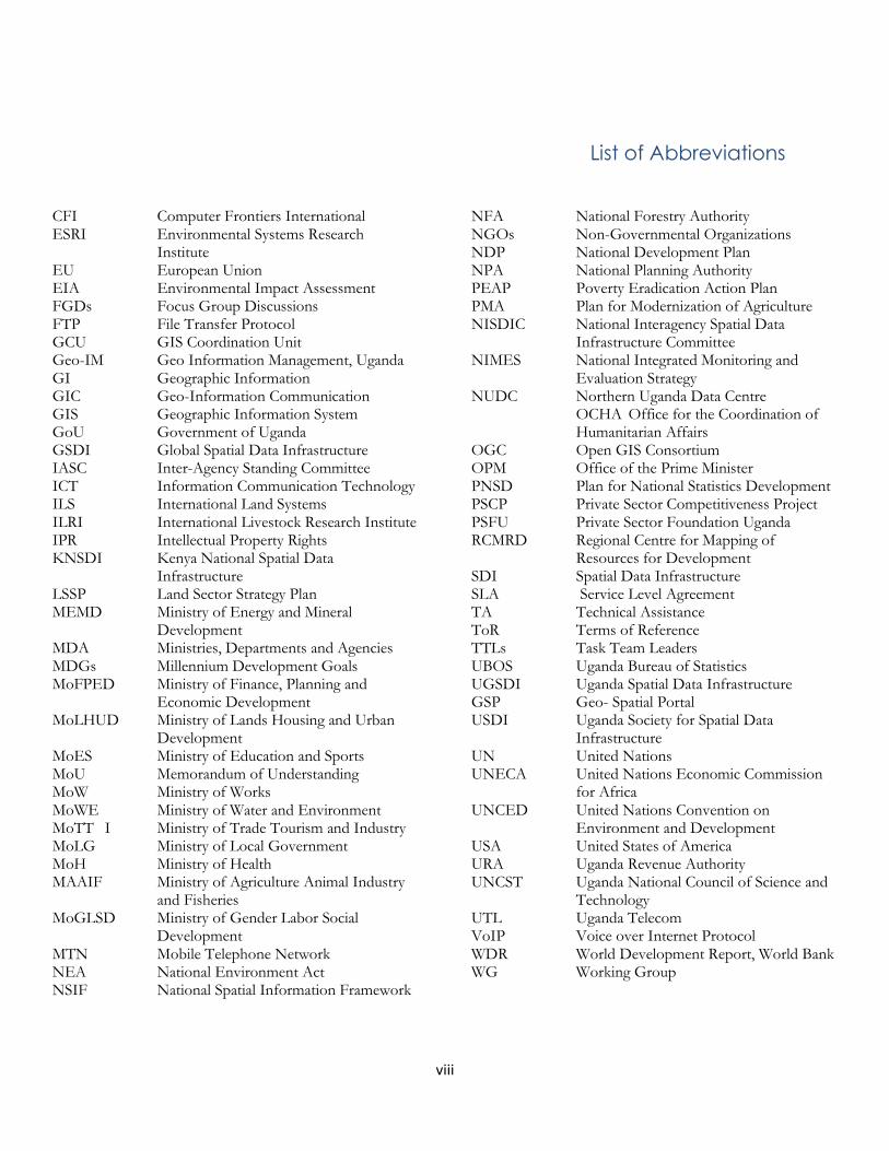
List of Abbreviations
CFI Computer Frontiers International ESRI Environmental Systems Research
Institute EU European Union EIA Environmental Impact Assessment FGDs Focus Group Discussions FTP File Transfer Protocol GCU GIS Coordination Unit Geo-IM Geo Information Management, Uganda GI Geographic Information GIC Geo-Information Communication GIS Geographic Information System GoU Government of Uganda GSDI Global Spatial Data Infrastructure IASC Inter-Agency Standing Committee ICT Information Communication Technology ILS International Land Systems ILRI International Livestock Research Institute IPR Intellectual Property Rights KNSDI Kenya National Spatial Data
Infrastructure LSSP Land Sector Strategy Plan MEMD Ministry of Energy and Mineral
Development MDA Ministries, Departments and Agencies MDGs Millennium Development Goals MoFPED Ministry of Finance, Planning and
Economic Development MoLHUD Ministry of Lands Housing and Urban
Development MoES Ministry of Education and Sports MoU Memorandum of Understanding MoW Ministry of Works MoWE Ministry of Water and Environment MoTT I Ministry of Trade Tourism and Industry MoLG Ministry of Local Government MoH Ministry of Health MAAIF Ministry of Agriculture Animal Industry
and Fisheries MoGLSD Ministry of Gender Labor Social
Development MTN Mobile Telephone Network NEA National Environment Act NSIF National Spatial Information Framework
NFA National Forestry Authority NGOs Non-Governmental Organizations NDP National Development Plan NPA National Planning Authority PEAP Poverty Eradication Action Plan PMA Plan for Modernization of Agriculture NISDIC National Interagency Spatial Data
Infrastructure Committee NIMES National Integrated Monitoring and
Evaluation Strategy NUDC Northern Uganda Data Centre
OCHA Office for the Coordination of Humanitarian Affairs
OGC Open GIS Consortium OPM Office of the Prime Minister PNSD Plan for National Statistics Development PSCP Private Sector Competitiveness Project PSFU Private Sector Foundation Uganda RCMRD Regional Centre for Mapping of
Resources for Development SDI Spatial Data Infrastructure SLA Service Level Agreement TA Technical Assistance ToR Terms of Reference TTLs Task Team Leaders UBOS Uganda Bureau of Statistics UGSDI Uganda Spatial Data Infrastructure GSP Geo- Spatial Portal USDI Uganda Society for Spatial Data
Infrastructure UN United Nations UNECA United Nations Economic Commission
for Africa UNCED United Nations Convention on
Environment and Development USA United States of America URA Uganda Revenue Authority UNCST Uganda National Council of Science and
Technology UTL Uganda Telecom VoIP Voice over Internet Protocol WDR World Development Report, World Bank WG Working Group

ix
Executive Summary
Spatial Data Infrastructure is a framework of
spatial data, metadata, users and tools that are
interactively connected in order to use spatial data
in an efficient and flexible way. It may also mean
the technology, policies, standards and
institutional arrangements that facilitate the
availability and access of spatial data. It promotes
Geo-Information sharing which is an essential
resource in addressing poverty, disease,
environmental degradation and poor
infrastructure. Since SDI helps in promoting
Geographic Information for decision makers, it
means the prospect of better decision making
hence improved management, development of
national resources and monitoring development
outcomes. A sustainable national SDI in Uganda
requires access to data, clear vision and goals,
good governance, effective network services,
indicative financial requirements, human resource
requirements and good communication channels
among others.
Following the findings of the first interim report it
is obvious that in order for the UGSDI to be
successful, a clear strategy has to be implemented.
This study proposes vision and goals for the
UGSDI, institutional/ organizational
arrangements to manage the UGSDI and give
ways in which the UGSDI will be administered
and its operationalization. The Institution
arrangement specifically refers to the
organizational approach for the NISDIC; this also
involves the other structures within the MDAs for
example the Ministries that are in charge of
specific data production. The national mapping
organizations/agencies, industry, the role of the
private sector marketing and promotion of
national SDI initiatives, it also emphasizes data
issues which refers to standards, availability of
digital datasets in the country, the policies and
standards, inadequate technology problems in the
institutional arrangement, availability of trained
manpower, policy issues and other issues like
metadata which involves thematic datasets,
fundamental datasets, and then data clearing
house issues.
Policy issues and legal framework will deal with
issues like custodianship confidentiality, privacy
and liability, pricing, copyright, data access and
security, free and restricted access, ownership.
This will stretch in to the Capacity building, where
by the role of management in capacity
development will involve Recommendations for
outreach and capacity building options for
implementing a SDI training which is also an actor
in framework data development. Study visits GIS
awareness and introductory courses map
awareness course and education program basic
GIS, GIS awareness seminars for managers
MDAs and multi-sectoral uses of GI.
The communication strategy for UGSDI
awareness creation and information dissemination
involves the programs, goals of the UGSDI. The
overall strategy, communication process
objectives, target audiences both Primary and
Secondary Audiences, the general talking points in
the UGSDI messages will be having specific
themes, with opportunities and tactics which
facilitate delivery to the targeted audience. Some
of the strategies will involve publications, email,
website, PowerPoint presentations workshop,
seminar, conference, activities and other public,
opportunities, face-to-face meetings with key
partners and stakeholder groups.
All other communications channels will be utilized
as necessary evaluation, identified opportunities
and short-term activities, next steps resources
needed for implementation, proposed
architectures for, information, dissemination,
definition of UGSDI domain data contents- the
pre requisite , geospatial portal, formulation of
domain policy framework - another pre requisite
,proposed architecture of a Ugandan geospatial
portal, technical requirements

x
The Implementation plan for UGSDI involves
stages and outcomes these stages are divided in
quarters within a period of 5 years, each stage
yields an outcome that is used in the next stage,
issues, goals and proposed actions are also
discussed in this chapter with the expected
outcomes.
Lastly, it further illustrates the financial
requirements for the establishment of the UGSDI
through the establishment of the effective GIS
coordination Unit within NPA. It deals with three
major components; hardware, software and the
training aspect.
11
Chapter One
1.0 Introduction
Uganda has an area of 241, 035 square kilometers
and is „land locked‟ country with an estimated
population of 33.4 million. It is a rural nation with
an urban population amounting to 13%.
Uganda's economy has great potential. Endowed
with significant natural resources, including ample
fertile land, regular rainfall, and mineral deposits, it
appeared poised for rapid economic growth and
development at independence.
Having appreciated the benefits of a national SDI,
the Government of Uganda has mandated NPA
to handle SDI activities. NPA under the Ministry
of Finance and Economic Planning has been
chosen by the Government of Uganda as the lead
agency that will guide the development and
implementation of Uganda‟s NSDI. The main task
of National Planning Authority as defined by its
mandate is to manage national and decentralized
development planning in Uganda through a
participatory approach, with decision-making
being shared by all stakeholders. This requires
institutional structures that are vertically and
horizontally oriented, so that information (spatial
data) and decision-making can be easily shared in
order to overcome bottlenecks in the
development planning process. GIC and ESRI
Canada in collaboration with the stakeholders,
from which the current state of play of GI/GIS in
Uganda was derived, have proposed a strategy for
improving spatial data sharing by developing an
NSDI for Uganda. This strategy is designed based
on the visions and goals, institutional
arrangements, data issues, network services,
indicative financial requirements, human resource
requirements, awareness and communication
issues, indicative implementation programs and
other matters as may be agreed with the Uganda
Government and other national/international
stakeholders.
1.1 Vision
To provide a national infrastructure for access and
use of geospatial information in decision making
at local, regional and national levels for social
economic development.
1.2 Mission
Promote the production, access, sharing and use
of geospatial information for sustainable
development.
1.3 Targets
1.3.1 Goal One: Increase the awareness and
understanding of the vision, concepts,
and benefits of the UGSDI through
outreach and education.
Enhanced participation in the UGSDI will result from clearly communicating rationales for data sharing in languages appropriate to differing communities.
1.3.1.1 Objectives
Demonstrate the benefits of participation in the UGSDI to existing and prospective stakeholders.
Promote principles and practices of the UGSDI through formal and informal education and training.
Identify and promote the attitudes and actions that help to develop the UGSDI.
1.3.2 Goal Two: Develop common solutions
for discovery, access, and use of
geospatial data in response to the needs
of diverse stakeholders.
Once found, data would be easy to transfer and use in different applications; every data set would have full and complete metadata to ease the process of transfer and use.

12
1.3.2.1 Objectives
Continue to develop a seamless National Geospatial Data Clearinghouse.
Support the evolution of common means to describe geospatial data sets (metadata).
Support the development of tools that allow for easy exchange of applications, information, and results.
Research, develop, and implement architectures and technologies that enable data sharing.
1.3.3 Goal Three: Use community-based
approaches to develop and maintain
common collections of geospatial data for
sound decision-making.
Large centralized national data holdings are costly to assemble and maintain. The most accurate and highest resolution data are created and maintained close to the locations where they are used. This goal looks toward developing the organizational relationships and technologies to build distributed locally maintained collections of data.
1.3.3.1 Objectives
Continue to develop the National Geospatial Data Framework.
Provide additional geospatial data that citizens, governments, and industry need.
Promote common classification systems, content standards, data models, and other common models to facilitate data development, sharing, and use.
Provide mechanisms and incentives to incorporate multi-resolution data from many organizations into the UGSDI.
1.3.4 Goal Four: Build relationships among
organizations to support the continuing
development of the UGSDI
As much as possible, this goal intends to identify potential new resources and, at the same time, identify and remove difficulties.
1.3.4.1 Objectives
Develop a process that allows stakeholder groups to define logical and complementary roles in support of the UGSDI.
Build a network of organizations linked through commitment to common interests within the context of the UGSDI.
Participate with the international geospatial data information community in the development of a global geospatial data infrastructure.

13
Chapter Two: Institutional/Organizational Arrangement
2.1 Organizational Approach
The organizational approach focuses on the
individuals or actors involved in the publication
and discovery of geospatial information, defines
their roles and responsibilities that these actors
play and states the essential functions that human
or computer-assisted services should be able to
conduct in the interest of resource discovery for
the UGSDI. The major actors are discussed in the
next sections.
2.1.1 National mapping
organizations/agencies
National mapping organizations/agencies play a
key role in ensuring that accurate, up-to-date
geospatial framework data are developed and
maintained. Such data are key to, among others,
the promotion of sustainable economic
development, improvement of environmental
quality, resource management, upgrading public
health and safety, modernization of governments
either local, national or regional, and the responses
to natural and other disasters. Therefore such
organizations play a vital role in facilitating the
development of a UGSDI.
2.1.2 Industry
Industry is working to provide technology, data
and services in support of UGSDI activities. In
particular, industry plays a key role in ensuring
that effective information technologies (consistent
with standards and specifications being developed
by such groups as ISO and OGC) exist and that
these technologies support UGSDI requirements.
Therefore it is imperative that such organizations
play an important, proactive role in the
development of a UGSDI.
2.1.3 Other agencies, organizations and
institutions
There are many other agencies, organizations and
institutions that collect and use geospatial data
that along with national mapping
organizations/agencies and industry can and
should play an important role in UGSDI activities.
It is important here that ways be sought to
encourage cooperation, collaboration and
communication among as many UGSDI
stakeholders as possible.
As in any development it is important to
understand who the stakeholders are and what
roles each will play. For example:
In most national infrastructures
government suppliers are key
stakeholders. How they will play in the
development and operation of the data
access component of the infrastructure
depends strongly on government policies
regarding data distribution, cost recovery,
etc.
Commercial entities will generally play a
strong role as providers of tools and
services but may also be suppliers of
primary and value added data. It is
important to understand the relationship
between the commercial sector and the
infrastructure as whole, e.g. will the
commercial sector have a role in planning
the infrastructure? What types of business
arrangements will be supported in the
infrastructure?
The final category of stakeholder is the
consumer or end-user. Their use of the
data access element infrastructure is
dependent on a number of factors
including: the functionality of the
infrastructure tools, the amount and
quality of the content accessible,
operating policies, infrastructure business
model (will consumers be charged for
access?), etc.
2.1.4 Policy /Organization Environment
The importance of developing a supportive
policy/organizational environment should not be
14
underestimated. Potential stakeholders will only
become active participants if they see advantages
for their organizations and if they do not feel
threatened by the infrastructure. This
policy/organization environment will vary from
country to country and will need to be worked out
closely with the stakeholders. The buy-in and
commitment from senior management of all
stakeholders is critical to the success of the
infrastructure as a whole and to that of the access
element in particular. The Canadian Geospatial
Data Infrastructure (http://www.geoconnections.
org/) is an example of an infrastructure
implementation that has developed an
organization based on broad stakeholder
participation. Some of the issues that need to be
considered in the development of the supportive
policy/organizational environment are:
• Distributed/autonomous suppliers.
• The management of the data should be done
as close as possible to source. This ensures the
accuracy and quality of the data. This is also
dependent on the mandate of each data
producer.
• Commercial and government stakeholders
need to feel comfortable as active participants
in the infrastructure. They should not feel
threatened by infrastructure business models
or policies.
• Multiple levels of “buy-in”; low barrier to
entry to encourage participation by as many
stakeholders as possible.
• The access component of the infrastructure
must provide multiple levels of buy-in from a
low cost option with limited benefits, e.g.
basic advertising of products and services, to
higher cost options that offer increased
benefits, e.g. distributed search connections to
the stakeholder‟s inventory. This allows
stakeholders to choose a level of participation
that best meets their business and operational
objectives. This is especially important in the
early operation of the access component as
many stakeholders will want to “try” it out
and may not be prepared to expend much
effort until they see how it works.
• Sustainable long term business models.
•The access component of an infrastructure
must provide an environment that supports a
variety of stakeholder/ data provider‟s
business models. The development of a
sustainable business model for the operation
of the access component is critical to the long
term success of the entire infrastructure.
2.1.4.1 Role of the private sector
The role the private sector as suppliers/users of
data, services, and technology and as potential
operators of the access infrastructure must be
clearly defined.
2.1.4.2 Marketing and promotion
The access component of an infrastructure must
develop a marketing and promotion plan to build
up the level of awareness and participation as
quickly as possible. It is important to get a critical
mass of suppliers so that potential participants will
see the benefits of joining the infrastructure.
Potential benefits to suppliers include:
• Economies of data collection, closest to the
source
• Reduced operational costs
• New clients (national and international)
• Data reuse (reuse vs. recollection or
conversion)
• Common tool and service reuse
• Advertising
• Benefits of “free” portrayal
• Enabling/supporting broad new
applications, e.g. disaster management, value
addition
As was reported in (http://www.gsdi.org/
docs2004/Cookbook/cookbookV2.0.pdf)
thousands of organizations spend billions of
dollars each year producing and using geographic
data. Yet, they still do not have the information
they need to solve critical problems. There are
several aspects to this problem as discussed below:

15
• Most organizations need more data than
they can afford. Frequently, large amounts of
money are spent on basic geographic data,
leaving little for applications data and
development.
• Some organizations cannot afford to collect
base information at all. Organizations often
need data outside their jurisdictions or
operational areas. They do not collect these
data themselves, but other organizations do.
• Data collected by different organizations are
often incompatible due to differences in scale
and coordinate systems. The data may cover
the same geographic area but use different
geographic bases and standards. Information
needed to solve cross-jurisdictional problems
is often unavailable.
• Many of the resources organizations spend
on geographic information systems (GIS) go
toward duplicating other organizations‟ data
collection efforts. The same geographic data
themes for an area are collected again and
again, at great expense. Most organizations
cannot afford to continue to operate this way.
Framework initiatives will greatly improve this
situation by leveraging individual geographic data
efforts so data can be exchanged at reasonable
cost by government, commercial, and
nongovernmental contributors. It provides basic
geographic data in a common encoding and makes
them discoverable through a catalogue in which
anyone can participate. Using Web mapping and
advanced, distributed GIS technology in the
future, users can perform visual cross-
jurisdictional and cross-organizational analyses
and operations, and organizations can funnel their
resources into applications, rather than duplicating
data production efforts.
Uganda has adopted as the terminology for
geospatial data infrastructure – Uganda National
Spatial Data Infrastructure (UGSDI). This
incorporates all the spatial data infrastructure
projects being carried out in the country. The
National Planning Authority (NPA), a parastatal
under Ministry of Finance and Economic
Planning has been selected as the coordinating
agency. In the past, most SDI related activities had
been handled by Uganda Bureau of Statistics with
major support from non-government bodies like
Geo-IM Working Group. Although the official
implementation body, National Planning
Authority (NPA) had no previous provision for
SDI within its framework until recently with the
formation of NISDIC (see Figure 1). The
organizational framework as envisaged by
NISDIC is shown in Figure 2.
2.2 National SDI Initiatives
In recent years there have been a growing number
of significant SDI initiatives in Uganda that can
and will act as a stimulus to UGSDI development.
Some of these initiatives are highlighted below.
These initiatives are now being documented in
several ways and this documentation provides a
valuable resource for proponents of the UGSDI."
2.2.1 Ministry of Lands, Housing and Urban
Development (MoLHUD) Land
Information System Project (LIS)
The Government of Uganda received funds to
provide infrastructure and other related facilities
to support growth and improve the land registry.
The Land Component is among the main
components of the PSCPII earmarking the need
for updating the land records, secure and
rehabilitate the land registers and implement the
Land Information System to improve the land
tenure security and facilitate land transactions in
Uganda
Maintenance of the National Land Registry and
related cadastral maps is under the mandate of
MoLHUD. As an ongoing project, the Ministry
with support from the World Bank through
Private Sector Foundation Uganda is carrying out
a review and assessment of the existing records
management system and actions, incorporating
land registration records, cadastral and other
information; and designing the LIS architecture

16
and prepare specifications and functionalities for
the LIS.
Based on the fact findings, analysis of the current
situation and results of the previous studies,
proposed measures for the improvement of the
situation have been made. These measures include
the final design of the system, implementation of
the pilot project to test the design, preparation of
a detailed implementation plan and once
successful, the implementation of the system for
the whole country. This is one of the SDI
component projects that could be of great
impetus to the current proposal for the UGSDI. It
could be integrated into the institutional structure
of the proposed UGSDI through the nomination
of at least a member by MoLHUD to integrate the
issues of the ongoing LIS into the Proposed SDI
initiative at the NPA/NISDIC. Currently the
chairman of NISDIC and one other sitting
member are from Ministry of Lands, Housing and
Urban Development.
2.2.2 GEO-IM
Geo Information Management (Geo-IM) Working
Group is a group of technical persons from UN
Agencies, Non-Governmental Organizations and
Governmental bodies that aims at discussing and
implementing better ways and systems to facilitate
the exchange of information, standard procedures
on data sharing, standardization and
harmonization of datasets among partners,
carrying out coordinated and joint assessments. As
noted in the 1st interim Report, it is a group which
is generally supported by UBOS and UNOCHA;
it draws members from the NPA which is the
mandated government agency to handle the
UGSDI issues and others from the other
government agencies that practice the use of
GI/GIS/SDI. This WG has for sometime acted
as a data clearing house. The latter is within the
proposed mandate and responsibility of NPA who
are expected to partner with the WG on their
activities. As highlighted in the proposed structure
for the UGSDI, other MDAs shall have at least a
member representing them at the newly formed
NISDIC. The selection process of these members
within the MDAs shall be based on a rotation
system.
2.2.3 Uganda Bureau of Statistics
Uganda Bureau of Statistics is one of the
government agencies that is evident in fulfilling its
main task “to provide high quality central statistical
information services on social, environmental, and economic
conditions of the country”. This is heavily dependent
on other institutions to produce exchange and
update data in a standardized and orderly manner.
The success of UBOS has been in other words
dependent on the existence of a National Data
Infrastructure and institutional arrangements for
exchange and dissemination of data. UBOS has
also developed on its own, distinctive geo-codes
that uniquely identify all administrative areas down
to village level for geospatial data acquired in the
2002 census (Karatunga, A. 2002). Due to a need
for trends analysis, the GI service under UBOS
plans to geo-code all previous data sets backwards
through 1990, 1980, and 1970 subject to
availability of funds (Muhwezi, 2004).
Furthermore, UBOS has conducted two phased
GIS review studies in 2007 and 2009. The
objective of the review studies was to conduct a
situational analysis of the current GIS initiatives
and establish a framework for GIS capacity
building and enhancement within the Ministries,
Departments and Agencies (MDAs) it was also
discovered and noted in the 1st interim report that
data is being updated after 10years cycle. Currently
data for the 2011 census is being updated.
Another key institution that has developed
metadata for its GIS datasets is NEMA and it is
available at www.nemaug.org.
2.3 National Planning Authority
In accordance with Section 5(1) of the NPA Act
(15 of 2002), the NPA Authority consists of a
Chairperson, a Deputy Chairperson and three
other members appointed by the President of the
Republic of Uganda, with the approval of

17
DEPUTY
EXECUTIVE
DIRECTOR
ENVT &
NATURAL
RESOURCE
DECENTRALIZED
GOVERNANCE
HEALTH &
NUTRITION
GOVERNANCE HUMAN
RESOURCE
ACCOUNTS AUDIT
S
I C T PHYSICAL
PLANNING
SOCIO
DEVT
MACRO
ECONOMICS
RESEARC
H M&E
EXECUTIVE
DIRECTOR
3 BOARD
MEMBERS
CHAIRMAN
DEPUTY
CHAIRMAN
DIRECTOR DIRECTOR DIRECTOR DIRECTOR DIRECTOR
INFRASTRUCTURE
Figure 1: NPA Structure

18
Parliament. These form the full time Members of
the Authority. NPA has a Secretariat headed by an
Executive Director. The NPA Secretariat is
organized into five technical departments pursuing
specific functions, roles and responsibilities
required to achieve the organization‟s mission and
mandate1.
2.3.1 NPA Research, Innovation,
Monitoring and Evaluation
Department
This department undertakes innovative research
related to development planning and management,
and also provides leadership into the monitoring
and evaluation of development programs and
other interventions.
2.3.2 NPA Decentralized Development
Planning Department
This department develops, oversees, monitors,
and evaluates an efficient institutional framework
and strategy for cost-effective and participatory
decentralized development planning and
management in Uganda.
2.3.3 NPA Human Resource Planning,
Development and Capacity Building
This department assesses the current human
resource planning and development, as well as
institutional capacity building initiatives in place. It
institutes coordination and harmonization
mechanisms, encourages the participation of all
the stakeholders and creates a specific national
databank for this function. Ultimately, this process
should lead to a national policy on human
resource planning, development and optimal
capacity utilization, supported by a conducive
environment for investing in people for poverty
eradication.
2.3.4 NPA Finance and Administration
Department
This department is responsible for the design and
review of NPA‟s Finance and Administration
1 http://www.npa.or.ug/staff.php
Policies and guidelines, and overseeing their
effective implementation.
As was stated in the first interim report, the
Government of Uganda has mandated the
establishment of SDI within NPA by establishing
NISDIC. The Spatial Data Infrastructure
Committee is under the authority of the Ministry
of Finance, Planning and Economic
Development. NISDIC comprises of a ruling
body, a committee, sub-committees or working
groups under the GIS Coordination Unit. Sub-
committees constitute the platforms for more
collaboration among stakeholders by pooling
resources and harmonizing initiatives to avoid
duplication.
Figure 1 outlines the current structure of National
Planning Authority which is mandated as the lead
agency for the current SDI study in Uganda.
2.4 Proposed Organization Structure
2.4.1 NSDI Council (ruling body)
Composed of the NPA chairperson with about
10-15 appointed members. These appointed
members should come from different key
ministries, state bodies, geodetic and geo-
informatics community. This council provides the
overall leadership during the process of creating a
national SDI. Its main roles are administration,
review of policies and legislation.
The specific tasks of the Council should include:
Making decisions on the aims, strategies,
policy and basic activities of the UGSDI
institutional framework;
Harmonizing the UGSDI activities with
the state policy and programs;
Coordinating and planning the use of the
state funds for the UGSDI development;

19
2.4.2 National Inter-Agency Spatial Data
Infrastructure Committee (NISDIC)
It consists of 3 representatives from the Council,
3-5 members from the NPA and the heads of
working groups. In the event that there is more
than one stakeholder/agency within a ministry, a
rotational system should be used for membership
representation within NISDIC.
The NISDIC should be an active committee that;
Implements the UGSDI establishment
policies determined by the UGSDI
Council;
EXECUTIVE DIRECTOR
Proposals
Proposals
Decisions and Policies
Decisions and Policies
NSDI Council
NSDI Committee (NISDIC)
NP
A G
IS Co
ord
inatio
n U
nit
Co
mm
un
ication
, Co
ord
inatio
n, Tech
nical su
pp
ort
MDAs, Special Interest
Groups, Private Companies
GIS Units
Working Groups consisting of:
Ministries, Departments, Agencies (MDAs), Special Interest Groups, Project Heads
Standards
WG
Legal & Policies WG
Capacity Building WG
Dissemination WG
Other New WGs as required.
Figure 2: Proposed Institutional Framework for the UGSDI

20
Performs the work and tasks delegated to
it by the UGSDI Council;
Coordinates and monitors the activities of
the working groups;
Coordinates the implementation activities
of the UGSDI subjects related to their
establishment in accordance with the
UGSDI Council guidelines.
The NISDIC should report to the UGSDI
Council and is expected to work closely with
Ministries, Departments and Agencies and other
Spatial Data stakeholders in the public and private
sectors in execution of its duties.
2.4.3 Sub-Committees or Working groups
It consists of temporary and permanent work
bodies responsible for the concept and
implementation aspects. Their members should be
representatives of the local government authorities
at all levels, users and producers of spatial data,
research and educational institutions among
others. These bodies should be appointed or
dismissed by the NISDIC, with approval of the
UGSDI Council. The prerequisite for forming a
body is a clearly defined mission and a detailed
execution plan. A working group can form
different sub-groups so that its objectives are met
in a timely way.
For example, NISDIC should start by creating 4
working groups (WGs) between 2010 and the first
quarter of 2011. They should include UGSDI
standards WG, Legal affairs WG, capacity building
WG and Dissemination WG. In the second
quarter of 2011 three additional working groups
should be created: WG for building the UGSDI
establishment capacities, WG for linking the
UGSDI program and e-Government and one for
establishing a business model for the UGSDI.
2.4.4 The NPA GIS Coordination Unit
As GIS shall be introduced as a tool in the
organization of NPA, it is essential that the
Capacity Development Activities are directed
towards the organization. It will include both
specialist and non-specialist roles. Within the
organizational structure it will be a secretariat that
will provide continuous support in the UGSDI
development process, coordinate the work of all
UGSDI bodies, and provide technical support. Its
main tasks will include:
Setting up and maintenance of the central
UGSDI web portal,
Securing communication support, public
relations, services of leading projects,
services of quality control, etc.
This organizational structure is based on the
models developed by countries like Croatia,
Germany and the Netherlands.
Listed below are some of the proposed staff for
the NPA GIS Coordination Unit.
i) GIS and UGSDI Coordination
Manager: Focuses on stakeholder and
in-house GIS map production and use;
dataset and GIS capacity inventories; the
implementation, monitoring and
evaluation of UGSDI; WGs and
stakeholder coordination, analysis and
monitoring reports of WGs especially
those concerning several sectors such as
energy, regional development, education,
business development, social inclusion,
decentralization, etc; UGSDI help desk.
ii) Geo-Information Management and
Spatial Analyst: Focuses on spatial
analyses; development, management and
maintenance of the geo-spatial portal and
metadata service catalogue; data
dissemination mechanism (s); site up-
dates and checks for consistency, data
quality, standards, metadata; creation and
presentation of a demo-solution to
simulate data-exchange principles; review
and analyse reports; UGSDI help desk

21
iii) ICT and Database Developer: Focuses
on administration of the IT Infrastructure
of the Unit; develops and manages the
UGSDI associated databases/systems;
gather technical requirements, develop
specifications, define information
deliverables and devise ways of their
dissemination; draft training materials;
UGSDI help desk.
iv) Communication Officer: Main contact
person; focuses on public awareness
creation; organising meetings; writing and
dissemination of reports and meeting
minutes; manages the contact list
database, devise ways of information
dissemination; keep abreast and
communicate about local, regional and
international UGSDI events.
2.5 Broad Framework TORs for the
first 4 Working Groups
The working groups are technical task forces for
the UGSDI. They comprise of experts in different
fields and their function is to make
recommendations on given terms of references to
NISDIC.
Standards WG
Standards facilitate the sharing of information
and computer resources within organizations.
They are also assist in representing data
efficiently and facilitate the exchange,
comparison and analysis of information. The
terms of reference for the standards WG
include:
- Framework data (scale)
- Coding System
- Reference System (ellipsoid,
projection)
- Exchange format
- Metadata Standards
Legal and Policies WG
The task of this Working Group is to
consider all relevant aspects related to
data policy and to develop proposals on
the issues to be addressed in the UGSDI
framework legislation. These include:
- Copyright
- Liability
- Privacy
- Data policies (access, restriction,
pricing, enforcement of copyright for
original data and secondary data, etc).
Capacity Building WG
The function of the Working Group on
Capacity Building is to provide direction
for the UGSDI work in the fields of
capacity building, technical assistance and
training. Its broader ToRs include:
- Training
- Curriculum
- Research
- Sensitization
- Liaison
Dissemination WG
This working group is charged with the
development of a framework for. Below
are broad ToRs for this WG to fulfill its
mandate:
- Clearinghouse
- Metadata
- Website for UGSDI

22
Chapter Three: Data Issues
3.0 Data Issues
Implementation of previous SDI projects in
Uganda has in the past faced numerous problems.
Some of these problems are highlighted below:
3.0.1 Availability of Digital Datasets in the
Country
Most of the fundamental and thematic datasets in
the country are still in analogue form. Few of
them are current but most are outdated. So
implementation of UGSDI project will inevitably
run concurrently with coordinated revision of the
existing datasets and conversion of them to digital
form. This is a serious handicap to the UGSDI
project. Ministry of Lands Housing and Urban
Development through the LIS project has
commenced the updating of the land records in
order to secure and rehabilitate the land registers
and implement the Land Information System to
improve the land tenure security and facilitate land
transactions in Uganda. This will eventually be
integrated into the NGDI spatial datasets.
3.0.2 Policies and Standards
There is no common policy and standard on the
production, usage and sharing of Geo-
information. This is obviously delaying the
UGSDI project in the country and therefore
needs to be designed in order to promote
efficiency and success of the proposed UGSDI.
3.0.3 Inadequate Technology
The physical linkages which will be the major
access to UGSDI systems will be through a range
of mechanisms, including telephone lines, Local
Area Networks, Wide Area Networks and other
Integrated Service networks (Adeoye et al, 2002).
Our telecommunication facilities are still
problematic and can cause problems to UGSDI
project. Hopefully, the introduction of wireless
communication network is an asset to UGSDI but
the service in Uganda still needs a lot of
improvement. Closely connected to this is the
electricity power needed to support all the
activities of UGSDI. Electricity power supply has
remained a problem and in some places simply
does not exist.
3.0.4 Problems in the Institutional
Arrangement
The Institutional arrangement adopted for now
has just been proposed thus the roles of many
public and private agencies producing and using
GI are yet to be defined. Conflicts of interests
exist in so many areas especially the most
government agencies that have been participating
in Data collection (primary data collection) and
must be tackled to ensure successful
implementation of the UGSDI project. The
structure cannot guarantee cohesive framework
for effective coordination of geospatial activities
in the country. The proposed organizational
framework of National Planning Authority seeks
to be flexible so as to satisfy the needs of GI
producers and users.
3.0.5 Availability of Skilled Human
Resource
Despite the developments taking place in our
education and capacity building efforts, availability
of properly trained personnel is still a problem in
the implementation of the UGSDI project. The
training strategy proposed in this report is
expected to solve this problem (see Chapter 5).
3.0.6 Policy Issues
There are no formal agreements or processes
underway to address privacy, access, use, pricing,
and liability. Agencies have autonomous
approaches to these subjects, especially in the
areas of pricing and copyright. In practice, digital
geographic data sets are sold off-line on a single-
license basis at prices ranging from 1% to 5% of
the production cost. Analogue data sets (photos or
maps on paper) are sold at the cost of duplicating
them. Private firms mainly produce customized
geographic data and charge their clients about

23
130% of the production cost. In general, this type
of data is not available to the public.2
3.0.7 Other issues
Some of the datasets are 40 to 60 years
out of date or are still to be undertaken
for the first time. This creates the
challenge of updating them.
lack of funding or lack of will to collect
data or update the current datasets
Maintenance of up-to-date data in the
future and acquiring funding for this and
share the costs among users and suppliers
is still a challenge.
3.1 Standards
Ideally, metadata structures and definitions should
be referenced to a standard. One benefit of
standards is that they have been developed
through a consultative process (with other
"experts") and provide a basis from which to
develop national or discipline-oriented profiles. As
standards become adopted within the wider
community, software programs will be developed
to assist the industry in implementing the
standard. The consistency in metadata content and
style is recommended to ensure that comparisons
can be made quickly by data users as to the
suitability of data from different sources. The
standardisation activities are a logical part of the
data repository establishment and maintenance
process. To develop a standard is not a time-
limited project, but a dynamic process that
involves users and different producers of geo-
spatial data. This activity should mainly include:
The Feature catalogues development, Dictionary
of Terms and definitions in GIS Metadata
specifications, administrative boundaries, data
model development (see example) acceptance, if
applicable international standards.
2 www.gsdi.org/docs2004/Cookbook/cookbookV2.0.pdf
The linkage to international standards requires that
these standards are available. ISO-standards are
available through the national standardisation body,
OGC-standards can be provided directly from the
Open GIS Consortium (OGC). This also requires the
involvement of the national body that is in charge of
standards that is Uganda National bureau of
Standards (UNBS)
SDI standards in this case deals with issues that
involve standardizing datasets, metadata, data
sharing mechanisms, pricing, hardware and
software used. One of the goals of UGSDI is
information sharing; therefore, standardization is
of vital importance to enable interoperability of
information systems. Tools, applications and data
effects on each other and therefore, processes for
developing standards must consider the
interactions. The aspects of standardization that
are of importance to UGSDI include;
Data (production) standards,
Data presentation,
Transfer/exchange standards,
Hardware and software standards
The Standards for GI usage are therefore reflected
in three primary themes, namely:
i) Portability: this refers to the ability to use
and move data, software, and custom
applications among multiple computers
and operating system environments
without retooling or reformatting.
ii) Interoperability and information access: this
refers to the ability of users to connect
and retrieve information from multiple
systems.
iii) Maintainability: addresses the use of
standards to promote long-term and
efficient updating, upgrading, and the
effective use of computer systems and
databases.
These standards should conform to both
national and international standards.

24
3.1.1 Proposals
The following are proposals for the formulation,
maintenance and enforcement of data standards:
The Uganda National Bureau of
Standards should be brought on board to
take charge of implementing national
standards related to spatial information.
Since these standards will be adapted
from ISO, we should give them a name
for reference purposes. For example
Uganda Spatial Information Standards
(USIS 1900 Series). In Uganda, the Geo-
IM Working group has gone a step ahead
in standardizing and sharing their
datasets. These datasets are the most
widely used datasets in Uganda‟s GI
community and can be found on
(http://www.ugandaclusters.ug).
However, most of these datasets are un-
interoperable and are geared towards
helping the humanitarian community.
Therefore, there is need to re-develop the
above fundamental datasets and
standardize them with conformance to
both national (USIS 1900 Series) and
international standards (ISO19100 series)
so that they may fit in to the system.
There should be a standards manual and a
separate document to describe spatial data
specifications and subsequently be
developed to help data producers and
users to refer to them during production
and data utilisation.
The NISDIC should have a sub-
committee or working group to certify the
compliance of the standards.
3.2 Metadata
The effective use of existing statistical and
geographical data resources depends, to a great
extent, on the knowledge of the existence of each
particular data. Once created, and properly
documented geo-spatial data can be used by
multiple systems for different purposes. A number
of studies have established that the effective use
of data is inhibited by poor knowledge of the
existence of data, poorly documented information
about the data sets, and data inconsistencies. The
location and evaluation of available data sets can
be done using metadata.
Metadata is the data about data. It includes details
such as the geographical extent of data, quality of
data, currency of data and the supplier of the data.
These details are described in a metadata structure
and they enhance the use of GI in making
appropriate decisions. This definition reflects the
nature of metadata, that it can be considered also
as detailed catalogue containing the identification
and description (technical characteristics, extent,
origin, accuracy, availability among others) of
existing data sets.
The metadata can help the concerned users find,
evaluate and use geo-spatial data. This
considerably improves the use of existing data
sets, contributes to efficient planning of new data
capturing activities, avoids the overlap of these
activities and saves costs. Thus to organise and
make metadata available is a very cost-effective
measure to start the process of building a Spatial
Data Infrastructure. It is therefore recommended
that as one of the immediate activities, the
metadata set for all the statistical and geographical
data existing within NPA and the other MDAs be
created. As part of the UGSDI strategic
development plan, the GIS software should be
made available to NPA and the MDAs. This
software can be used to create the standardised
metadata for all existing geo-spatial data sets and
access to this can metadata be organised using the
internet.
Metadata assists the user to determine how best to
use the data. It also benefits the data producing
agencies as well, because as personnel changes in
an organization, undocumented data may lose
their value due to little understanding of the
contents and uses by the new staff. Moreover, lack

25
of knowledge about other organization‟s dataset
can lead to duplication of effort. The value of a
dataset is therefore dependent on its
documentation.
Geospatial data producers should provide
metadata for each dataset they produce and any
subsequent updates. The metadata provided
should conform to national and international
standards
The metadata content should include the
following information at the minimum:
Data quality (positional accuracy, attribute
accuracy, temporal accuracy, lineage,
completeness and logical consistency)
Geospatial data organization
Spatial reference (coordinate system,
datum, map projection)
Identification information (name of data,
geographic coverage)
Entity/attribute information (formats,
type, measurement units)
Distribution information (distributor,
format, access protocol, procedure).
3.2.1 Fundamental datasets
The fundamental datasets refer to datasets with
national coverage needed consistently by more
than one user. The UGSDI Committees should
come up with a list of the fundamental or core
datasets that will be common and easily accessible
to all (see Table 1).
Although different data providers may provide
components of the fundamental datasets, the
datasets they provide must conform to the
national standards so that there is ease in
interoperability and integration into other datasets.
This will help different organizations to easily
spatially analyze their datasets.
Some of the fundamental categories of datasets
for the UGSDI include:
Geodetic control
Digital imagery
Place names
Administrative boundaries
Parcel boundaries
Transportation
Hydrology
Vegetation
Elevation, Utilities and so on.
3.2.2 Thematic datasets
A thematic dataset is a dataset that focuses on a
specific idea or theme. It illustrates a particular
subject and contrasted the general dataset, in
which the variety of geological and geographical
phenomena regularly appears together. The
contrast between both of them lies in the fact that
thematic datasets use the base data. Thematic
datasets also emphasize spatial variation of one or
a small number of geographic distributions. They
can also be referred to as geospatial datasets that
may be required for specific applications and are
often derived by adding value to one or more
fundamental datasets. There are two categories of
thematic datasets:
a) Thematic datasets that are produced only
by legally mandated agencies like oil
pipeline corridor map
b) Thematic datasets that are produced
according to specific user requirements,
for example Tourist map, soil map,
meteorological datasets, agricultural map
etc.
3.3 Data Clearinghouse
A clearing house is a distributed network of
geospatial data producers, managers, and users
linked electronically. It is a repository structure,
physical or virtual, that collects, stores, and
disseminates information, metadata, and data. A
clearinghouse provides widespread access to
information and is generally thought of as
reaching or existing outside organizational
boundaries. It incorporates the data discovery and
distribution components of a spatial data
infrastructure (see Figure 4).

26
For the UGSDI, it will be centered at the NPA
and managed by the NISDIC council which will
be solely in charge of data issues proposed in the
UGSDI.

27
Chapter Four: Policy Issues and Legal Framework
4.0 Policy Issues and Legal
Framework
A spatial data infrastructure (SDI) is a framework
of spatial data, metadata, users and tools that are
interactively connected in order to use spatial data
in an efficient and flexible way. It may also mean a
national network-based solution to provide easy,
consistent and effective access to geographical
information maintained by public agencies
throughout a country that provides and promotes
the use of geographical information in support of
political, economic and social development.
This involves a number of stakeholders who may be categorized as the; Users, Academic community, Public and private sector, Nongovernmental organizations and associations, government Ministries responsible for data production.
As noted in the First Interim Report, Uganda has
no specific legal framework for spatial data
sharing. Furthermore, there is no national law on
spatial data sharing and pricing. Therefore, it is
imperative that a legal framework is initiated to
enforce the implementation of national standards
as is the case in South Africa. It is essential that
the new legal framework be put in place to
address such legal issues related to the UGSDI
Initiative, and further that there be harmonious
linkages with other related government policy
documents such as the ICT policy, the draft
National Land Policy and the e-government
strategy.
The law encompasses all the activities in relation
to data production, access and the costs attached
to it, who is responsible for the collection of
which data and the specific standards to follow,
development of the meta data.
4.1 Custodianship
Data Custodians are responsible for the safe
custody, transport, storage of the data and
implementation of the rules concerning data.
While data stewards are commonly responsible for
data content, context, and associated rules, they
are also responsible for what is stored in a data
field, while Data Custodians are responsible for
the technical environment and database structure.
They may sometimes be referred to as Database
Administrator (DBA), or Data Modeler, they also
ensure that access to the data is authorized and
controlled, Data stewards are identified for each
data set to ensure technical processes to sustain
data integrity, ensure processes exist for data
quality issue resolution in partnership with Data
Stewards, technical controls to safeguard data
added to data sets are consistent with the common
data model, versions of master data are
maintained along with the history of changes,
change management practices are applied in
maintenance of the database they also ensure that
data content and changes can be audited
The custodianship of geospatial information is a
crucial component of UGSDI. Since most
fundamental datasets are provided by public
organizations, it is often necessary to identify an
authoritative source of datasets which are
produced using public funds as this provides
accountability for fundamental datasets.
The custodian should be the person or
organization who is responsible for the
production, storage, management and distribution
of the dataset on behalf of another organization
(in this case the government of Uganda). A data
custodian is delegated to protect the
confidentiality, integrity and availability of the
data.

28
The producer of public funded data should be the
custodian and not owner, managing the data as a
trustee for the community and the authoritative
source of the fundamental dataset in its care.
4.2 Ownership
The owner of a geospatial dataset should be the
person or organisation who privately funds data
production, storage, management and distribution.
Other responsibilities of the owner of the dataset
include:
• Quality control and assurance
• Data content and formats
• Validation and maintenance
• Storage and security
• Maintenance and updates of metadata
• Accessibility of the data through supply of
the metadata to the Clearinghouse.
4.3 Confidentiality, Privacy and
Liability
In the case of confidentiality, privacy and liability
of the datasets the following is proposed:
Data providers should disclose or make
available their datasets on request unless it
is prevented by law.
Only geospatial data related to national
security should be granted confidentiality.
However, confidential data may be shared
at the discretion of the custodian.
A geospatial data custodian/owner should
not be accountable for the integrity of
data that has been modified by a user.
A geospatial data custodian/owner should
be deemed to possess indemnity against
any liability arising from unlawful use of
the dataset.
A user should report, to the provider and
the Clearinghouse, any error which in
his/her opinion affects the quality of a
geospatial data, and should do so in the
shortest time possible after discovering
the error.
The user reporting any error should
provide sufficient information to enable
the provider to identify the record(s) that
contain error(s) that make the data
unsuitable, and where possible, provide
evidence of the error.
4.4 Copyright
There are no clear copy right laws in Uganda.
Copyright laws are required to ensure the proper
implementation of UGSDI. Other issues to
consider include:
A geospatial data custodian should own
the copyright or intellectual property right
of the data.
For value added data, the producer
should own the copyright of the new data
and acknowledge the source of the
original data.
For integrated datasets, the producer of
the data should own the copyright
provided that permission has been
obtained from the copyright holder(s) of
the individual base data.
A geospatial data custodian and user
should, prior to the utilization of any
geospatial dataset to which the user has
gained access, enter into a licensing
agreement with regard to the use of the
dataset. The licensing agreement should
provide for the following:
- The duration of the agreement
- The legal protection of the copyright
of the custodian and any other
interested party
- A maximum number of permitted
users within the organization where
an organization is the beneficiary of
the agreement
- Any other provisions that the parties
may deem necessary.
A data user should not supply data to a
third party unless this is covered by a

29
licensing agreement between the user and
the provider.
4.5 Pricing
Most of the datasets used in Uganda are freely
shared; however, in the private sector some of
them are priced. There is no standard pricing
mechanisms for datasets produced for the public.
Much as the public needs the protection of the
law, different prices will always be set for different
users. Therefore, a standard affordable price
should be discussed and agreed upon. The high
cost of geospatial products and services are seen
as a barrier to free access by the majority of users.
For publicly funded geo-information and services,
the aim of pricing policy is not to achieve cost
recovery, but to make geospatial information and
services more accessible, affordable, and
ultimately more effective and efficient. The
purpose is to have a uniform policy in the public
sector on pricing of spatial information and
services.
4.6 Data Access and Security
One of the objectives of the UGSDI is to share
data and avoid duplication of efforts. Data sharing
is made possible through coordinated and
structured access to documentation (metadata)
about geospatial data owned by public and private
sector organizations.
In Uganda there is one common place or portal
(http://ugandaclusters.ug) for storing and
dissemination of some datasets. However, this
portal is not designed for visualizing, discussion,
dissemination and metadata. This makes it hard
for the users to recognize, visualize and use the
existent datasets or suggest ways of improvement.
The datasets shared on this portal are also un-
secure, not up-to-date, lack the standardization
needed and are geared to serve mainly the
humanitarian community.
Transparent access to various geospatial data can
provide relevant information for many
applications leading to value added services and
market opportunities. Access to data is made
possible through the development and
implementation of a central one-stop geo-spatial
portal with a metadata catalogue and
establishment of Clearinghouse within a legal
framework. However, data access protocols need
to be developed in order to define a set of
consistent and workable arrangements that can be
used by the GI community to streamline access to
data and derived information products while
recognizing the rights of all parties (custodians
and users).
There should be two categories of data access,
namely:
a) Restricted access
Only geospatial data related to national
security should be granted restricted access,
such data should be made available to users
by agreement with data owner(s) on a case-
by-case basis under conditions stated in a
license agreement (e.g. mining petroleum
deposits). Note: The UGSDI concept
precludes the restriction of geospatial
datasets
b) Free Access
There should be free access under a legal
framework to other public and private
datasets.
Data may be reclassified from one access category
to another as circumstances change over time, and
this should be subject to the approval of the data
custodian and agreement by stakeholders. All
archived data should be made available to agreed
parties as described in the access protocol.
An access registration system, which should be
simple to understand and designed to minimize
compliance costs, should be put in place in the
form of a search/order form. The form would
require the user to specify queries for data with
certain properties while providing such

30
information as name and organization of user,
address, intended use of data among others
The mode of access should be defined in the
access protocol and it may include online access
(view only, direct to user‟s database for example
via ftp, brokered – providing specification of data
access request to secondary access service, or
offline access (hardcopy delivery or softcopy
delivery on storage media such as Flash disk or
CDROM). In addition, the top clearinghouse
should be established at NPA.
Each geospatial data producing agency should
establish a metadata database server as a UGSDI
node, linked to the top Clearinghouse which will
be at NPA
Reasonable security measures should be put in
place to minimize damage to unauthorized access,
modification and loss of current and archived
data. These include access to;
Authentication devices,
Hardware and software devices,
Computer firewall protection,
General fire protection,
Physical security, etc.
Each of the UGSDI nodes should be on an
intranet to ensure full security and “closed user”
access. The nodes should be linked to the master
UGSDI Server – which will serve as the gateway
on the Internet for the intranet nodes. The
UGSDI Gateway should be a web domain name
(e.g. http://www.UGSDI.go.ug) with individual
Nodes linked to the UGSDI domain. The UGSDI
gateway on the wide area protocol and the
UGSDI Intranet would require sufficient
bandwidth of a communication backbone.
4.7 Other Policy Recommendations
The following are recommendations for the
development of policy:
GI/GIS projects should include a training
component for various grades of human
resource (operators, supervisors,
managers, etc) in relevant aspects of geo-
information.
The NPA and other stakeholders should
carry out public awareness programmes
from time to time on UGSDI related
issues.
All institutions of learning offering geo-
information related programmes should
review their geo-information curricula on
a regular basis in order to match changes
in technology.
Impact assessment of geo-information
projects on the society should be carried
out by the UGSDI stakeholders.
Government, through the NPA
Coordination unit should encourage
research on new innovations in geo-
information and its applications.
Continuing Professional Development
(CPD) for geo-information practitioners
should be mandatory.
Geo-information stakeholders should be
encouraged to build strategic liaisons with
reputable local and international partners.
Accreditation of geo-information training
programmes based on international standards and
practices should be encouraged.

31
Chapter Five: Capacity Building
5.0 Capacity Building
Capacity Building is much more than training and
includes human resource development3, this is
basically the process of equipping individuals with
the understanding, skills and access to
information, knowledge and training that enables
them to perform effectively. Organizational
development is also one of the aspects of capacity
building which deals with the elaboration of
management structures, processes and procedures,
not only within organizations but also the
management of relationships between the
different organizations and sectors (public, private
and community). It also includes institutional and
legal framework development, which involves
making legal and regulatory changes to enable
organizations, institutions and agencies at all levels
and in all sectors to enhance their capacities.
5.1 The Role of Management in
Capacity Development
An important barrier to change is an
organization‟s capacity to adopt new standards
and technologies. While the introduction of
specialized software is relatively easy, its effective
use depends on the technical capabilities as well as
organizational support. Awareness creation of SDI
components should be considered down to the
lowest level and with strong management support
and leadership. Capacity development should be a
prime concern of senior management. It includes
the theoretical issues and the practical (hands-on)
capabilities to implement the SDI components.
3 HRD consists of any process or activity that, either initially
or over the longer-term, has the potential to develop adults‟
work based knowledge, expertise, productivity, and
satisfaction, whether for personal or group/team gain, or for
the benefit of an organization, community, nation
As job specific technical competencies will be
stipulated, it will be necessary to review positional
titles, remuneration packages and salaries. The
staff rotation system in the Department of
Geological Surveys" in Zimbabwe is a case of
"best practice" in how "brain drain" can be
avoided and serves as an example of how staff can
be motivated within a "Learning Organization".
This system is designed to enhance the capacity of
personnel within the department, therefore
reducing the need for external recruitment of
technical staff.
The personnel resources for SDI in many
countries are very limited since most of the GIS
implementations being built up are understaffed.
A pool of qualified staff has to be created if the
projects are to become sustainable. Human
capacity development and long term career
planning should be of prime concern to senior
management. It includes the training, theoretical
issues and practical capabilities to implement
projects and programs, as well as the working
conditions. The working conditions need to be
considered not only with respect to salary, but
even more importantly with respect to the work
climate, motivation and professional perspectives.
This will minimize the issue of brain-drain.
Senior management of all concerned institutions
(data producers) should consider the development
of standards as a priority. They should closely
supervise technical work groups and ensure that
the desired results are produced. Matters like the
standardization of data and the harmonization of
classification schemes cannot be left to technicians
alone because they entail political decisions. Senior
management should be acknowledged as a driving
force behind the build-up of a SDI.

32
Funding and Donor involvement: In order to
ensure funding, it may be more persuasive to
potential funders to have something to show
already (for example, a clearinghouse system)
rather than a concept document alone. In
addition, justification for the limited cost of this
initial development may well be found within
existing projects or initiatives (for example,
documenting data holdings is a part of sound
information management).
Innovative use of resources can ensure that funds
stretch a long way. For example, with a 'carrot and
stick approach', incentives can be created for the
adoption of SDI principles. Using small, non-
repeating grants to stimulate the development of
the application layer of the SDI can work well
where there is broad base of existing expertise that
can be encouraged.
GIS implementations in developing countries are
often functioning under special conditions that
need to be considered during the initiation of a
SDI at national or regional level. In many
countries the lack of local financial resources
means that SDI implementations are not
financially sustainable and therefore depend
primarily on donor funds. Usually donor support
for these projects is provided under certain
conditions such as a time limit for implementation
after which there are no further disbursements of
funds. The future of many of these systems is
uncertain beyond the end of international
assistance.
Another aspect of donor-funded SDI
implementation is that often the projects have
been initiated by donors according to their own
objectives and little attention has been paid to the
requirements and capacities of the host
organizations. The result is that there is
insufficient coordination of the technical support
and funding activities of different donors. In some
cases donors may not be willing to work with each
other and this can impose limits on the co-
operation or data exchange between projects that
are funded by different donors. A lack in capacity
to coordinate donor activities coupled with
competition among the donors themselves can
also hamper SDI initiatives.
Under these conditions, the co-operation with
donors is a critical aspect of the development of a
national SDI. While the existing co-operation
should not be exposed to strain, a co-ordinated
SDI-based approach would change the priorities
for its implementation. This potential conflict
could be avoided if donors would be invited as
partners to take part in the participative process
defining the components of a nationwide SDI.
Reports of different SDI funding mechanisms
from Australia and Portugal suggest that the
provision of central funds is an important
contributor to accelerated SDI development.
5.2 Recommendations: Outreach and
Capacity Building Options for
Implementing a SDI
A workshop organized with the stakeholders to
define and create a national coordinating body,
considering its structure in terms of an existing or
newly created institution, working groups and/or
committees. In countries where GIS
implementations are highly dependent on donor
involvement in terms of funding and technical
expertise, donor representatives should be
considered as stakeholders and included in the
process of building a SDI. The coordinating body
needs to be mandated to manage the required
activities and devise an action plan to coordinate
the activities. Considerations need to be given to
the necessary resources for implementing the
strategy, policy or plans and activities, considering
staff, technical know-how, material, and funding
opportunities such as innovative partnerships.
Formal working groups should be organized
around well-defined objectives, strategies, plans,

33
programs, and actions, are not simply for informal
and limited consultations. These working groups
would be made up of interested parties and
experts to deal with specific aspects of SDI such
standards (metadata, exchange), national data sets,
policy, clearinghouse and how to assimilate
existing technological solutions into the local
context.
In order to make this proposed UGSDI a success,
there is a need for capacity building within the
MDAs. This will include:
The presence of a concerted human resource
development and training approach to
recruiting, training and retaining skilled
workforce;
Appropriate training materials in use
Training provider capacity
Quality control and certification systems in
the training sector
Sufficient financial resources for training, and
many other relevant factors identified in the
2001 SDI study by the Swedish consortium
Who are the actors in framework data
development?
Users and producers of detailed data, such as
utilities
Users of small-scale, limited geographic data,
such as street networks, statistical areas,
and administrative units;
Data producers who create detailed datasets
as a product or a service;
Data producers who create low-resolution,
small-scale, limited themes for large areas;
Product providers who offer software,
hardware, and related systems; and
Service providers who offer system
development, database development,
operations support, and consulting services.
Non-profit and educational institutions also create
and use a variety of geographic data and provide
GIS-related services. They cover the full spectrum
of data content, resolution, and geographic
coverage. Depending on the organization‟s
activities, data use may range from high resolution
data over small areas, as in facility management, to
low-resolution data over wide areas, as in regional
or national environmental studies
5.3 Training
The training of human resource within NPA
should include the types of training courses that
are directly linked to Spatial Data management,
Geographic Information Systems etc. The
specialized training for staff of NPA/NISDIC
should also be provided for the representatives
from other key ministries. The training should
include but not limited the issues as follows:
Different GIS systems and use of GIS
software;
Spatial data integration and analysis;
Use of satellite imagery and digital maps
for cadastral data management, property
valuation, planning etc.;
GPS technique and its use for land survey
and cadastre;
Basics of computer aided property
valuation and physical planning;
Other issues to ensure the efficiency of
data processing.
The Professional Training should be provided for
the staff to enable them to carry out all the
functions of the centre (NISDIC) including the
maintenance of the databases.
The Professional Training should involve the staff
who already have proper level of education in the
area of GIS, computer science. The program
should include but not limited to:
- Database Management Systems
(including proposed in System solution);
- GIS and spatial data analysis;

34
- Processing and use of the satellite
imagery;
- GPS and data processing;
- Spatial data management and
dissemination, metadata.
5.4 Study Visits
The study of experiences of other developing
countries and Europe in the field of SDI for
decision-making support and monitoring and
evaluation is important at all level of central and
local governments. Study visits should be planned
and held for NISDIC and other stakeholders. The
purpose of the visits is an increasing of awareness
and familiarization of government official with
best examples and practices of SDI
implementation and use for essential information
processing and presentation for decision-making.
5.5 Course and Education Program
We propose a course and education program with
training on four different levels, for the members
of NPA.
Level 1 – GIS awareness creating and
Introductory Courses. Introductory
courses to introduce people without
background in the areas of mapping,
GIS and computers to the subjects.
Seminars should be held for the key staff
and managers who are the key
stakeholders.
Level 2 – short courses that give the
participants an overview and basic
understanding of the subjects, either as
an independent unit, or as a preparation
for further training.
Level 3 –full day courses to develop
specialized skills within the different
areas of GIS.
Level 4 – Overseas training for key
people specializing in the main
disciplines of GIS.
These training courses shall be followed up by on
job training in the management of spatial data
within NPA. The course components are briefly
described below:
5.5.1 Map Awareness
Basic understanding of the nature of a map,
whether digital or in paper form is a prerequisite
for both producing and using geographic maps
and data. The participants should get a general
understanding of what maps and map data are.
They should be familiar with terms such as map
projection and datum, be able to assess the
suitability of a map for a given purpose, and be
familiar with concepts such as base-maps,
thematic maps.
5.5.2 Basic GIS
The power of GIS, in particular, lies in its ability
to combine or integrate data of many different
types for analysis purposes. In order for this
integration to take place, however, the participants
need to have a basic understanding of the nature
of the system as well as the data. The participants
should also get fundamental knowledge about the
potential use of GIS, and an understanding of the
various GIS functions such as data capture,
analysis, storage updating. They shall also get an
understanding of data quality as well as data
formats and common standards.
5.5.3 GIS awareness seminars for managers
The involvement of managers level into the
process of capacity building is a crucial issue for
the success of a UGSDI. The demand of GIS
services will grow together with the growing of
understanding of the managerial level of the basic
principles of GIS and its role as an instrument for
the socio-economic data processing, analysis and
presentation as well as basic knowledge of GIS
capabilities in the supporting of decision-making
process. Seminars should be held for the key staff
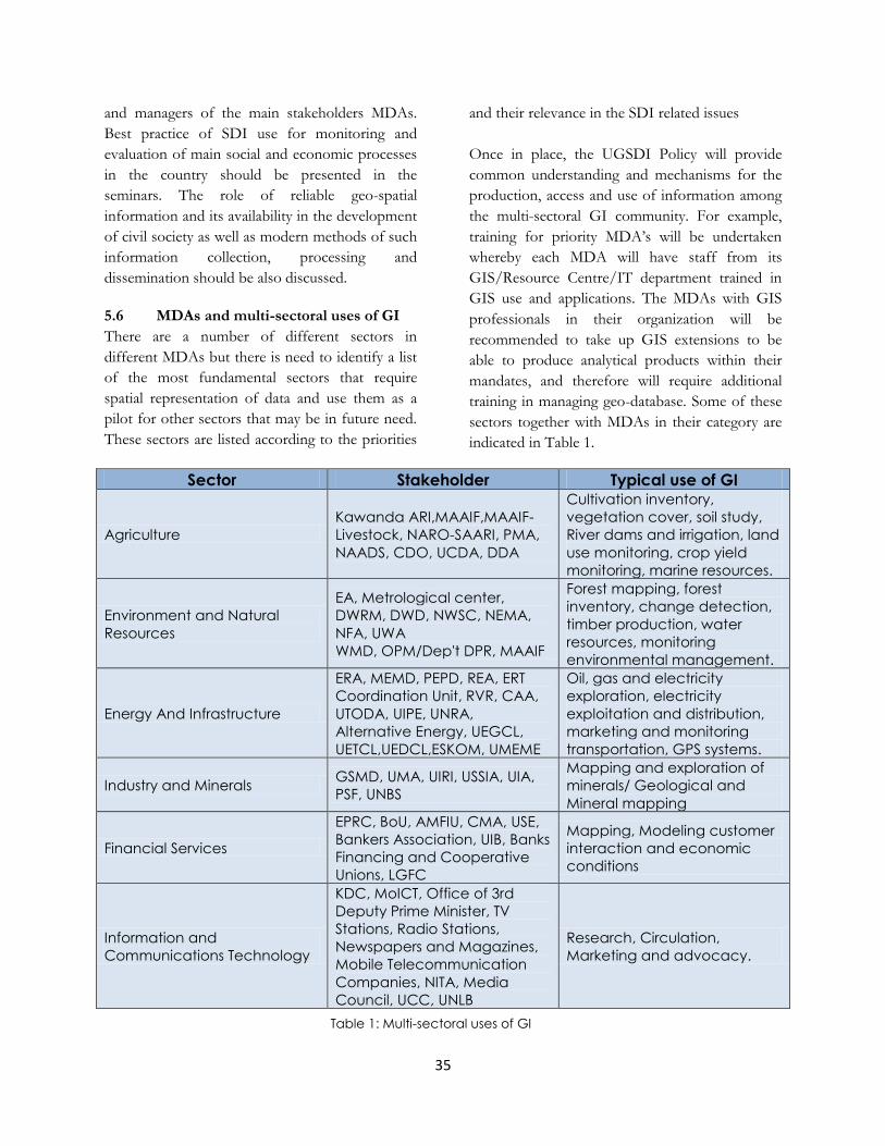
35
and managers of the main stakeholders MDAs.
Best practice of SDI use for monitoring and
evaluation of main social and economic processes
in the country should be presented in the
seminars. The role of reliable geo-spatial
information and its availability in the development
of civil society as well as modern methods of such
information collection, processing and
dissemination should be also discussed.
5.6 MDAs and multi-sectoral uses of GI
There are a number of different sectors in
different MDAs but there is need to identify a list
of the most fundamental sectors that require
spatial representation of data and use them as a
pilot for other sectors that may be in future need.
These sectors are listed according to the priorities
and their relevance in the SDI related issues
Once in place, the UGSDI Policy will provide
common understanding and mechanisms for the
production, access and use of information among
the multi-sectoral GI community. For example,
training for priority MDA‟s will be undertaken
whereby each MDA will have staff from its
GIS/Resource Centre/IT department trained in
GIS use and applications. The MDAs with GIS
professionals in their organization will be
recommended to take up GIS extensions to be
able to produce analytical products within their
mandates, and therefore will require additional
training in managing geo-database. Some of these
sectors together with MDAs in their category are
indicated in Table 1.
Sector Stakeholder Typical use of GI
Agriculture
Kawanda ARI,MAAIF,MAAIF-
Livestock, NARO-SAARI, PMA,
NAADS, CDO, UCDA, DDA
Cultivation inventory,
vegetation cover, soil study,
River dams and irrigation, land
use monitoring, crop yield
monitoring, marine resources.
Environment and Natural
Resources
EA, Metrological center,
DWRM, DWD, NWSC, NEMA,
NFA, UWA
WMD, OPM/Dep't DPR, MAAIF
Forest mapping, forest
inventory, change detection,
timber production, water
resources, monitoring
environmental management.
Energy And Infrastructure
ERA, MEMD, PEPD, REA, ERT
Coordination Unit, RVR, CAA,
UTODA, UIPE, UNRA,
Alternative Energy, UEGCL,
UETCL,UEDCL,ESKOM, UMEME
Oil, gas and electricity
exploration, electricity
exploitation and distribution,
marketing and monitoring
transportation, GPS systems.
Industry and Minerals GSMD, UMA, UIRI, USSIA, UIA,
PSF, UNBS
Mapping and exploration of
minerals/ Geological and
Mineral mapping
Financial Services
EPRC, BoU, AMFIU, CMA, USE,
Bankers Association, UIB, Banks
Financing and Cooperative
Unions, LGFC
Mapping, Modeling customer
interaction and economic
conditions
Information and
Communications Technology
KDC, MoICT, Office of 3rd
Deputy Prime Minister, TV
Stations, Radio Stations,
Newspapers and Magazines,
Mobile Telecommunication
Companies, NITA, Media
Council, UCC, UNLB
Research, Circulation,
Marketing and advocacy.
Table 1: Multi-sectoral uses of GI

36
Sector Stakeholder Typical use of GI
Health, HIV and Nutrition
NDA, HC and Hospitals, HU,
NMS, JCRC, UAC, UVRI, IDI,
FPA
Epidemic location, prevention
and forecasting, facilities
planning and distribution.
Good Governance
MJCA, MFA, MIA, MoEI, EC,
Parliament, IGG, ICG, UJCC,
UML,
PSFU, NDI- Demgroup
Election incident Reports,
Visualization and Analysis of a
wide range of data types
Lands, Physical Planning,
Housing and Urban
Development
USMD, MoLHUD-Lands,
MoLHUD-Urban Development,
MoLHUD-Surveys, MoLHUD-
Physical Planning, NHCC, UAA,
ULA, LEM, ULC, LG and LB,
Town and County Planning
Boards, KCC
Surveying and mapping, land
reforms, urban and regional
planning, urban renewal and
change studies, feasibility
study, land use mapping, land
administration.
Peace And Resettlement OPM/UNDP
Feasibility of Proposed
Settlement Plans, Decision
Making
Population, Gender and
Social Development
PopSec, UNYC, NUDIPU,
UCRRN, NSSF, MoGLSD, MoPS,
UBOS
Decision Support System
Labor and Employment PIRT, UIA, BTVET, MoPS, Labor
Unions, Enterprise Uganda
Analysis of Employment rates,
Decision Making Tool
Tourism
UWA, UTB, UTA, Arts & Crafts,
UIA, Uganda Museum, UCTA,
UHOA, AUTAO, UHCA
Road network maps and
street guides, tourist centers
and hotel location, facilities
planning, development and
management, Geo-
referencing of historical
locations, research study,
culture preservation and sport
development
Justice, Defense, Security and
Rule of Law
OPM, State House, AC,
POLICE, Prisons, UHRC, UPDF,
CECORE, LRC
Political organizations, Security
agencies, Courts of
Judicature, DPP, HTN, ULGA,
Urban Authorities Association
Defense, crime prevention
and monitoring, logistical and
rescue operations.
Trade and Cooperatives
URA, UEPB, UIA, UMA, PSF,
Enterprise Uganda, EPRC,
UNBS
Revenue generation, Customs
and Immigrations, Taxation
Accountability
IGG, MFPED, AG, DEI, OPM,
Parliamentary Commission,
UDN
Plan, Monitor and Coordinate,
visual representation of
finance issues
Legislature
Parliamentary Commission,
MoLG, Courts of Judicature,
ULGA
Policies, Research, Decision
Making Tool
Table 1 (cont’d): Multi-sectoral uses of GI

37
Sector Stakeholder Typical use of GI
Public Sector Management &
Administration and Sub-
National Development
Planning
MoPS, OPM, LGFC, Public
Service Commission,
Parliamentary Budget Office,
NPA, MoLG
Taxation, land use, new town
development, utility services.
National statistics, economic
Planning, demographic
studies
Regional and International
Development MFA, EPRC
Assessment and Visualization
of Development
Implementation, Monitoring
and Evaluation NPA, OPM, UBOS, OP, EPRC
Planning and Monitoring of
development and population
growth
Table 1 (cont’d): Multi-sectoral uses of GI

38
Chapter Six: Communication Strategy for UGSDI Awareness Creation
and Information Dissemination
6.0 Communication Strategy for
UGSDI Awareness Creation and
Information Dissemination
NISDIC will work closely with the MDAs, local
governments, humanitarian agencies, academia
and private partners during the implementation of
the UGSDI. It will provide leadership, guidance,
standards and policy to further collaborative
activities that will develop, support, and
implement a National Strategy for Geospatial
Information – the UGSDI (Uganda National
Spatial Data Infrastructure).
6.1 Communication Strategy
An UGSDI Communication strategy should be a
program aimed at reaching out to the public on a
multi level perspective and creating awareness so
as to increase the use of UGSDI services and
encourage e-governance concepts for national
development. Such a strategy is critical in the
facilitation of the use of data and services by
people. It will seek to facilitate access to relevant
data sources and spatial information services by
any person as well as facilitate exchange and
acquisition of the key datasets with the various
stakeholders.
6.1.1 Overall Strategy
It is recommend that NISDIC, in concert with the
UGSDI Geo-spatial portal (UGSDI-GSP) and the
NPA GIS Communication Unit (NPA-GCU),
should embrace a leadership role on behalf of the
geospatial community to promote the significance
and value of geospatial information and the
UGSDI. The NISDIC communications strategy
which we are recommending should focus on the
benefits of intergovernmental and public/private
collaboration to enhance decision-making, to
leverage resources, to minimize redundancies and
to develop approaches to share geospatial data
and information.
As leaders in the effort to build a national
geospatial infrastructure, the recommended
approach should identify and celebrate best
practices and successful partnerships, and
encourage shared responsibilities among
stakeholders to achieve our common goal of
assuring access to reliable geospatial data.
6.1.2 Program Goals
Below are the proposed goals for the
communication strategy:
• Together with the public and private
sector partners, develop and implement a
coordinated proactive outreach strategy
supporting the development of a spatial
data infrastructure for the Nation.
• Assert NISDIC as the leader in the
geospatial community for policy,
guidance, and standards, and promote
programs that support the UGSDI (For
example, UGSDI-GSP as the leading
website for discovery and access, and the
NPA-GCU as providing the base
geography).
• Provide communications support for
NISDIC for future directions, teams and
activities.
• Identify and publicize best practices and
success stories in the development of a
collaborative national geospatial strategy.
• Communicate the relevance of spatial
data and the UGSDI to a wider
community and educate those who may
benefit from its value.
• Communicate the benefits of sharing data
and data “interoperability” - working
together to share information,
collaborate, and make information
available.

39
6.1.3 Communication Process Objectives
In order for the communication process to fulfill
its goals, the following needs to be established:
• Encourage MDAs, Local Governments
and other stakeholders to actively
promote the goals of the UGSDI using
incentives.
• Encourage state, private-sector and local
participation in NISDIC, UGSDI-GSP,
NPA-GCU activities and programs.
• Engage the geospatial community in a
discussion of the roles, responsibilities
and interrelationships of those
participating in building the UGSDI and a
commitment to contribute to mutual
goals, while acknowledging individual
roles and missions.
• Increase awareness and understanding of
the resources needed to build the UGSDI
and the importance of leveraging the
existing resources.
• Encourage the sharing of UGSDI “best
practices” and “lessons learned” among
the members of the geospatial community
of practice.
• Work collaboratively with GIS/SDI
partners to communicate and improve the
understanding of the goals, value and
benefits of the UGSDI in the national
Budget, Parliament, and key decision-
makers.
• Work more effectively with GIS/SDI
partners to gain their agencies‟ support
for the goals, values and benefits of the
NDSI.
6.1.4 Target Audiences
6.1.4.1 Primary Audiences
• Ministries, Departments and Agencies
(MDAs)
• Local Governments
• Humanitarian Community (UN, Local
and International NGOs, Donors and
Embassies)
• Public and Private sector non-geospatial
community of users
• Budget Office, Cabinet and Parliament
• Private sector geospatial community
6.1.4.1 Secondary Audiences
• Public interest groups
• National security (Uganda Police and
Uganda People‟s Defence Forces)
• Utilities including tele-communications
• Program managers
• Media outlets, e.g. TVs, radios, bill board
companies, news releases and
publications
This strategy should include the following issues;
concept, vision, benefits, legislation, project status,
policies, standards and metadata, fundamental
services, calendar of events, workshops, seminars
or conferences, career opportunities among
others.
The strategy gives recommendations on
approaches, mechanisms, and tools to use and
should identify specific actions to take in a timely
manner to accomplish the goal of increasing
awareness, understanding, and support. Table 2
below shows the main categories of
communication and their level of use to key
audiences.
6.1.5 UGSDI messages and issues for
discussion
THEME MESSAGE: “Building the spatial data
infrastructure for the nation – the UGSDI” roles,
responsibilities and relationships.
6.1.5.1 Target Audience: Central Government Partners
• The whole is greater than the sum of its
parts: all levels of government must
work together to communicate,

40
Communication Categories
Communication
Channels Key Audience
Be
ne
fits
Co
nc
ep
t
Vis
ion
Sta
nd
ard
s
Po
licie
s
Me
tad
ata
Fu
nd
am
en
tal Se
rvic
es
Jo
int
Bu
sin
ess
Ve
ntu
res
Wo
rksh
op
s, C
on
fere
nc
es
an
d
Eve
nts
Tec
hn
ica
l a
nd
Fin
an
cia
l ne
ed
s
Ca
ree
r O
pp
ort
un
itie
s
Cabinet, Parliament and
State Budget Office
Meetings,
Presentations, Brief
Reports.
UGSDI Council Members
(PS/Commissioners)
Meetings, Brief
Reports.
MDAs and LGs
Website, Email,
Meetings,
Workshops/Seminars,
Brochures, Reports,
video, Newsletters
Private Sector
Workshops/Seminars,
Website, Email,
Brochure
Humanitarian Community
Website, Email,
Meetings,
Workshops/Seminars,
video Brochures,
Reports, Newsletters
Academia
GIS day, Website,
Presentations,
Brochures, Reports,
Newsletters
Communities
Car stickers, Talk
shows, News, Media
publications
Table 2: Communication Categories
41
• Cooperate, coordinate and collaborate to
build the UGSDI.
• Build once; use many times. Complying
with standards saves time, money and
staff resources.
• Don‟t reinvent the wheel: the geospatial
data you need may already be in the
clearinghouse that is accessed through
the Geospatial portal.
6.1.5.2 Target Audience: MDAs and LGs
• Central government‟s geospatial
programs and resources provide valuable
information to meet local needs.
• Combining your local data with national
data aids decision-making.
• Sharing of geospatial information across
boundaries helps improve service
delivery and reduces costs.
6.1.5.3 Target Audience: Humanitarian Community
• The ability to relate places with events is
priceless.
• Everything happens somewhere. With a
map in-front of you, it‟s easy to get a
picture of (W)ho is doing (W)hat and
(W)here than when you have to read row
data.
• Geospatial data aids decision-making.
Business and government uses these data
in their decision to:
- Locate new businesses, hospitals,
schools and others.
- Respond to emergencies
- Plan transportation
- Establish good governance issues.
• Visualization of demographic data facilitates
decision-making.
6.1.5.4 Target Audience: Private-Sector Partners
Everyone has a part to play in building the spatial
data infrastructure for the nation. The following is
what can be done;
- Getting involved
- Sharing of data
- Formation of partnerships
- Spread the message
• Geospatial information gives decision-
makers the complete picture in a blink of
an eye.
- Here‟s how it benefits the
nation…
- Here‟s how it benefits you…
• Work together to build the UGSDI through
cooperation, coordination, collaboration
and partnering.
There is need to focus the message on awareness,
value and benefits, and results or outcomes.
6.1.6 Communication Opportunities and
Tactics
• Take advantage of existing avenues.
• Take the lead with support and
participation of partners.
• Leverage participation and promote each
others‟ activities.
• Reach out to target audiences for
information and collaborative
opportunities.
• Investigate opportunities such as
providing materials that other
organizations and GIS/SDI partners can
use to promote the message.
6.1.7 Primary Communication Avenues and
Actions
6.1.7.1 Publications
• Review and update existing NISDIC,
UGSDI-GSP and NPA-GCU
publications.
• Look at new opportunities and what
publications are needed to support them.
• Develop high-level UGSDI publications
in coordination with Media outlets.
Maintain independent publications
specific to NISDIC, UGSDI-GSP and
NPA-GCU needs.

42
• Provide information to be included in
the publications of other Central
Government agencies.
6.1.7.2 Email
• Establish an online joint-effort approach
for sharing, drafting and compiling
report documents by the NISDIC
members.
• Expand and publicize the email list
regularly.
6.1.7.3 Website
• Continue redesigning and updating the
UGSDI-GSP to support UGSDI unified
web presence.
• Provide for links to UGSDI-GSP web
pages.
• Create an online discussion forum where
users from all MDAs can debate and
share UGSDI views.
• News coming events for example other
nations experiences
6.1.7.4 PowerPoint Presentations
• Continue to make all NISDIC, UGSDI-
GSP and NPA-GCU PowerPoint
presentations available online.
• Provide a NISDIC PowerPoint
presentation template for use by
represented MDAs.
• Create PowerPoint slides on the basic
concepts of the UGSDI for use by NPA
staff, MDAs and partners.
6.1.7.5 Workshop/Seminar/Conference Activities and other Public Opportunities
• Develop a list of targeted conferences
and activities at each (workshops,
presentations, booths).
• Coordinate conference activities with
NISDIC member agencies and partners.
• Coordinate conference activities with
UGSDI-GSP calendar events manager.
• Sponsor internet-based teleconferences
for targeted audiences.
6.1.7.6 Face-to-face meetings with key partners and stakeholder groups
• Identify and prioritize.
• Set-up meetings for NISDIC, UGSDI-
GSP, NPA-GCU leadership team.
6.1.7.7 All other communications channels will be utilized as necessary
• News releases
• Newsletter
• Car Stickers
• Brochures
• Media Talk shows
• Articles in professional journals and
magazines
• Training and education
• Grant programs
• Communication by UGSDI Board,
NISDIC, Coordination Unit, and the
Geo-Spatial Portal discussions.
6.1.8 Evaluation
• Quarterly review and update of the
NISDIC/UGSDI-GSP/NPA-GCU
Communications Plan.
• Establish performance indicators and
measure progress against them.
• Use customer surveys to see if the
performance target(s) has been met.
6.1.9 Identified Opportunities and Short-
Term Activities
Engage a professional firm to develop and run the
programme.
6.1.10 Next steps
• Develop performance indicators for
three program objectives.
• Develop work plan with specific actions,
responsibilities and timeframes.
• Consider hiring communications expert
for next phase of project.

43
ACTION PROCEDURES TIMEFRAME
Establish a 5-minute “NISDIC Headlines”
agenda item at the end of each Coordination
Working Group meeting.
Distribute headlines by email immediately after the meeting
to
Coordination Group (CWG) members for talking points.
Begin 1st Quarter Dec/2010
Meeting
Identify and recommend a list of critical
conferences and public events.
Create preliminary list.
Share with CWG members.
Update regularly.
Finalize 15/01/2011.
Work with MDAs, Local Governments and
other stakeholders for joint presence at
conferences and other forums.
UGSDI-GSP & NISDIC meetings.
Share booth space & co-presence.
Begin Feb 2011
Sponsor a “UGSDI Partner” reception at
Regional Geo-Spatial conferences
(two per year).
Identify two non-geospatial organizations
3rd and 4th Quarter 2011
Identify UGSDI Partners at conferences and
exhibits. Display plaques, car stickers or
banners at booths at conferences.
Create NISDIC Member or Partner plaques, car stickers
and/or a banner
stating “NISDIC Partners: Working Together to Build the
UGSDI”
Distribute to members at 1st Half
Conference 2011.
Author a semi-annual article written for
agency publications (awareness level)
Identify names of the publications put out by other agencies.
Identify editors or contact information.
3rd Quarter 2011
Develop and stock PowerPoint slides about
the UGSDI, NISDIC and key messages.
For use by Governmental Partners in their PowerPoint
presentations
Feb 2011
Develop media kit and distribution strategy
Work with Governmental partners to implement a distribution
strategy.
April 2011
NISDIC/NPA-GCU meets with stakeholders Set-up meetings and agenda and hold face-to-face
meetings. Begin Feb 2011
Table 3: Actions and Timeframes

44
• Identify resources needed to implement.
• Investigate creation of an NISDIC
Communications Sub-committee or
Working Group to guide
implementation.
6.1.11 Resources needed for implementation
Short-term
• Funding for banners and plaques
• Funding for reception at the Regional
Conferences
• Funding for Communications contractor
(10 hours per week?)
• Additional funding for publications and
distribution
• Dedicated Staff to implement short-term
Long-term
• Fill NPA-GCU Communications Officer
position.
• Additional staff support (for mailing and
other non-technical activities)
6.2 Proposed Architectures for
Information Dissemination
The UGSDI is visualized as a single window
mechanism bridging spatial data users and the
national and regional geo-spatial data domain
agencies in the country. In order to make the
spatial and associated attribute data available to
user community, the active participation and
commitment with UGSDI is anticipated from
various data domain agencies following proposed
Metadata and data exchange standards. Thus, the
central and stakeholders data domain servers will
play a vital role in performing UGSDI operations.
As depicted in figure 3, NSDI in Uganda is
foreseen to be a network of domain specific data
servers (located at different MDAs, Local Governments
and Identified Stakeholders) and a central metadata
server (located at NPA GIS Coordination Unit)
working in unison to facilitate the data exchange
amongst users and data supplying agencies.
The most important driver of the architecture
design for the Centralized Data Warehouse
(CDW) is that of the mission critical nature of the
data. It is absolutely necessary that the data of the
CDW be available continuously. It is for this
reason that the UGSDI should choose a
centralized architecture for the CDW. The data of
the CDW is obtained from various sources,
through various means.
The different sources (MDAs) remain
autonomous and maintain full control over the
management and update of their spatial data.
The domain data servers form the backbone of
UGSDI data dissemination operations. This
section attempts to enlist the processes and
mechanisms to be established and various
activities to be carried out for implementation of
UGSDI domain servers.
The prime responsibility of a typical domain data
server is to serve the requisite data to a user based
on demand received via UGSDI Meta server. The
data supply could be routed through the metadata
server itself or it could be affected directly to the
user employing various options like media
transfer, FTP and others.
6.2.1 Definition of UGSDI Domain Data
Contents- The Pre Requisite
Domain data contents to hold the data will have
to be defined for the data that would form part of
UGSDI Domain servers. This will include all the
data that exists in analogue or digital form. Some
data, to be committed to UGSDI, may or may not
have been created conforming to the published
design standards available in the country. It is
therefore necessary to keep a flag on such data
sets, as these would require more elaborate efforts
for making them conform to UGSDI standards.
To define the data contents the following tasks
will have to be performed:
• Inventory of fundamental data sets and
identification of data to be committed to

45
NODAL AGENCY 13..n
MINISTRY OF LANDS,
HOUSING and URBAN
DEVELOPMENT
DATABASE SERVER
NODAL AGENCY 2
MINISTRY OF LANDS,
HOUSING and URBAN
DEVELOPMENT
DATABASE SERVER
NODAL AGENCY 3
UGANDA LANDS &
SURVEYS DEPARTMENT
DATABASE SERVER
NODAL AGENCY 4
UGANDA NATIONAL
ROADS AUTHORITY
DATABASE SERVER
NODAL AGENCY 12
UGANDA POLICE
DATABASE SERVER
NODAL AGENCY 5
UGANDA ELECTRICITY
DISTRIBUTION CO. LTD
DATABASE SERVER
NODAL AGENCY 11
UGANDA REVENUE
AUTHORITY
DATABASE SERVER
NODAL AGENCY 6
MINISTRY OF ICT
DATABASE SERVER
NODAL AGENCY 10
ELECTORAL
COMMISSION
DATABASE SERVER
NODAL AGENCY 9
UGANDA BUREAU OF
STATISTICS
DATABASE SERVER
NODAL AGENCY 8
MINISTRY OF HEALTH
DATABASE SERVER
NODAL AGENCY 7
MINISTRY OF
EDUCATION and
SPORTS
DATABASE SERVER
Partn
ership
Co
-op
eration
Partnership
Cooperation
USER 1 USER 2
USER 7 USER 8
USER n
USER
3
USER
4
USER
5
USER
9
USER
10
USER
1
DATA ACCESS RULES/POLICIES
GATEWAY/FIREWALLS
DA
TA S
ECU
RIT
Y
NET
WO
RK
PR
OTO
CA
LS UGSDI Coordination Unit
NODAL LEAD AGENGY 1.
NATIONAL PLANNING AUTHORITY (NPA)
METADATA MASTER SERVER
Clearing House
Figure 3: Proposed UGSDI Architecture
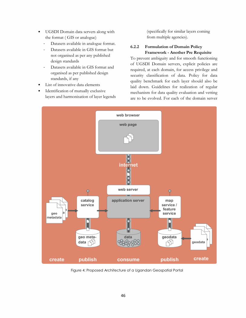
46
• UGSDI Domain data servers along with
the format ( GIS or analogue)
- Datasets available in analogue format.
- Datasets available in GIS format but
not organised as per any published
design standards
- Datasets available in GIS format and
organised as per published design
standards, if any
• List of innovative data elements
• Identification of mutually exclusive
layers and harmonisation of layer legends
(specifically for similar layers coming
from multiple agencies).
6.2.2 Formulation of Domain Policy
Framework - Another Pre Requisite
To prevent ambiguity and for smooth functioning
of UGSDI Domain servers, explicit policies are
required, at each domain, for access privilege and
security classification of data. Policy for data
quality benchmark for each layer should also be
laid down. Guidelines for realization of regular
mechanism for data quality evaluation and vetting
are to be evolved. For each of the domain server
Figure 4: Proposed Architecture of a Ugandan Geospatial Portal

47
nodes, jurisdiction has to be identified in terms of
data content and geographical location. The
policies should be within the overall UGSDI
framework.
Access privileges for each data content.
Various options could be employed
include:
- Selected groups of persons within the
repository agency,
- All users within repository agency,
- All Government and Local
Government agencies in Uganda,
- Any agency or individual in Uganda
and
- Global access
Security Classification of each data
element for example restricted/ open
Data quality benchmarks for each layer
(quality parameters/ declaratives as per
NISDIC guidelines)
Guidelines for realisation of regular
mechanism for data quality evaluation and
vetting
Geographic/ thematic jurisdiction of each
domain server
6.2.3 Geospatial Portal
Geospatial portals are expected to play a
prominent role in the efforts of many local and
national governments in making their geo-data
better and more accessible to potential users.
Technically the Geospatial portal is the place
where the geo-information can be found on the
web. Ideally, all governmental geo-information
Apache Tomcat
Spatial Databases
(SQL Server, Spatialite)
GEOSERVER
WMS, WFS, WCS, SLDs
INTERNET GIS CLIENT
(ArcGIS, uDig, OpenLayers, Luigi etc)
Java Virtual
Machine
Shapefiles
Uses
Figure 5: Technical Components
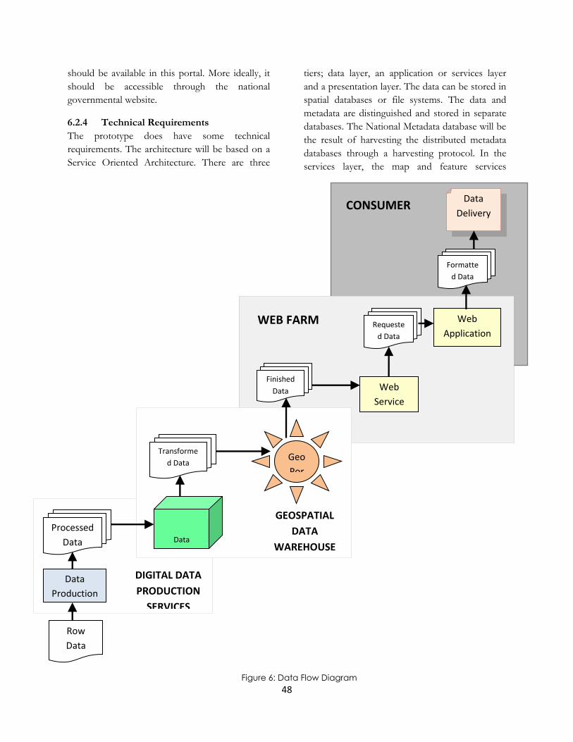
48
should be available in this portal. More ideally, it
should be accessible through the national
governmental website.
6.2.4 Technical Requirements
The prototype does have some technical
requirements. The architecture will be based on a
Service Oriented Architecture. There are three
tiers; data layer, an application or services layer
and a presentation layer. The data can be stored in
spatial databases or file systems. The data and
metadata are distinguished and stored in separate
databases. The National Metadata database will be
the result of harvesting the distributed metadata
databases through a harvesting protocol. In the
services layer, the map and feature services
Formatte
d Data
Data
Delivery CONSUMER
Finished
Data Web
Service
Requeste
d Data
Web
Application WEB FARM
Data
Production
Processed
Data
DIGITAL DATA
PRODUCTION
SERVICES
Row
Data
Data
Warehouse
Transforme
d Data Geo
Por
GEOSPATIAL
DATA
WAREHOUSE
Figure 6: Data Flow Diagram

49
(WMS/WFS) will be present in combination with
catalogue services (CS-W). In reality there could
be other services as well, but these are less
relevant for the prototype. The presentation layer
contains the web based client application showing
the information to the user. It provides the user
with interactivity to perform specific tasks carried
out by the underlying services. More components
are needed for the generic tasks. Figure 4 is a
summary the different components.
• Server with proper Operating system
• Java Virtual Machine
• Internet server (Apache)
• Application server (Apache TomCat)
• Mapserver (Geoserver, Mapserver, ESRI
ArcIMS )
• Spatial database (SQL Server, ArcSDE,
Postgres, Spatialite) or File based data
storage
• (Shape files)
• Services
• WMS/WFS (geoserver (FAO
http://www.fao.org/geonetwork))
• CS-W (eXcat)
• Internet GIS Client (ArcGIS, uDig,
OpenLayers, Luigi, etc).
Finally, the use of Geospatial portals based on
service oriented architecture requires map and
data services. OGC services are required to
guarantee interoperability. One should be
conscious of the versions and standards used as
well as the selected software components are
compliant to the correct versions of the standards.
The Figure 6 below shows data flow diagram
showing how raw data flows into the digital data
production services process all the way through to
the end process where it is delivered to the
consumer in its final form. The data production
process receives the raw data and performs
various tasks, which include parsing, assembling,
enhancing, and formatting the data. Once the data
has made it through this process, it is put in the
data warehouse. The data warehouse essentially
ingests the processed data and stores it. Based on
a series of business rules specific to each data
theme, the data is replicated to its sister data
center, and transformed for use in the UGSDI-
GSP. As it ages, the data is also archived in a near-
line state.
The shared government/commercial/public
approach is more typical of existing and well-
established infrastructures such as utilities and
transportation systems. If Uganda is to develop a
true data sharing infrastructure, it is recommended
that in terms of robustness and stability and focus
more on standards, best practices, and formal
professional development rather than specific and
ever changing technologies should be considered.

50
Chapter Seven: Implementation Plan for UGSDI
7.0 Implementation Plan for UGSDI
The implementation of the proposed strategy will
be one of the major tasks for NPA/NISDIC for
the next few years. It will require the involvement
and support of GIS strategy development at all
management levels within MDAs and many other
stakeholders.
The implementation of the proposed capacity
building and training strategy is a long-term
program that needs to be carefully planned,
monitored and supervised at all stages of
implementation. Substantial financial resources at
each stage of implementation are also required
especially on the initial stages to initiate the
process and make it sustainable. As it is indicated
in chapter two of this report, expatriate expertise
will be required.
A stage-by-stage approach is recommended for
this strategy for product development, generally
the implementation strategy should include the
major blocks of activities as follows:
Human capacity building and training of
personnel
Technical and technological capacity
upgrading
Key data sets decisions and acquisition,
and metadata development
Coordination and Standardization
Clearinghouse establishment and
development
Various applications dependent on geospatial data
and related technologies are rapidly assuming
mission critical status in today‟s nations. The ever
increasing convergence of geospatial and web
technologies in particular has opened up exciting
new prospects for the countries to revolutionize
their activity integration while at the same time
strengthen their decision support, planning and
operational capacities. By more effectively
integrating, managing and utilizing these
technologies to serve their geographic information
needs.
To ensure a successful and sustainable UGSDI,
the implementation strategy builds upon existing
geospatial data development efforts, provides for
highly visible results in the near-term, and sets an
appropriate framework for medium and long-term
UGSDI development and maintenance.
The UGSDI Coordination office is now
confirmed to be hosted by NPA as the
government agency Scope. UGSDI aims to
improve accessibility and exchange of geospatial
data and information between National
stakeholders that use and produce geographic data
and between the different Non-Governmental
Organizations and the Private sector.
The role of NPA/NISDIC's in UGSDI as
outlined below can help to facilitate the
establishment and coordination of the National
Spatial Data Infrastructure and to provide the
National UGSDI portal/node, fulfilling national
government's policies with respect to issues
relying on the use of geo-information,
coordination and execution of geo-information
disclosure activities for large enterprises,
companies or multi-nationals in order to fulfill
their Corporate Governance goals, capacity
building at national and regional level.
This participatory process will be essential to
delivering an effective UGSDI, building upon
consensus, good governance, and best enterprise
management and information sharing practices
that maximize the benefits of geospatial
information worldwide in terms of social,
economic and environmental development
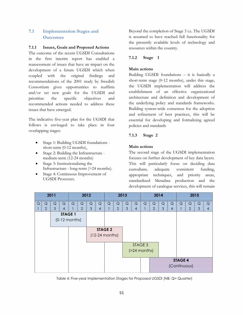
51
7.1 Implementation Stages and
Outcomes
7.1.1 Issues, Goals and Proposed Actions
The outcome of the recent UGSDI Consultations
in the first interim report has enabled a
reassessment of issues that have an impact on the
development of a future UGSDI which when
coupled with the original findings and
recommendations of the 2001 study by Swedish
Consortium gives opportunities to reaffirm
and/or set new goals for the UGSDI and
prioritize the specific objectives and
recommended actions needed to address these
issues that have emerged.
The indicative five-year plan for the UGSDI that
follows is envisaged to take place in four
overlapping stages:
Stage 1: Building UGSDI foundations - short-term (0-12 months),
Stage 2: Building the Infrastructure - medium-term (12-24 months)
Stage 3: Institutionalizing the Infrastructure - long-term (>24 months).
Stage 4: Continuous Improvement of UGSDI Processes.
Beyond the completion of Stage 3 i.e. The UGSDI
is assumed to have reached full functionality for
the presently available levels of technology and
resources within the country.
7.1.2 Stage 1
Main actions
Building UGSDI foundations – it is basically a
short-term stage (0-12 months), under this stage,
the UGSDI implementation will address the
establishment of an effective organizational
architecture and definition and development of
the underlying policy and standards frameworks.
Building system-wide consensus for the adoption
and refinement of best practices, this will be
essential for developing and formalizing agreed
policies and standards
7.1.3 Stage 2
Main actions
The second stage of the UGSDI implementation
focuses on further development of key data layers.
This will particularly focus on deciding data
custodians, adequate consistent funding,
appropriate techniques, and priority areas,
standardized Metadata production and the
development of catalogue services, this will remain
2011 2012 2013 2014 2015
Q
1
Q
2
Q
3
Q
4
Q
1
Q
2
Q
3
Q
4
Q
1
Q
2
Q
3
Q
4
Q
1
Q
2
Q
3
Q
4
Q
1
Q
2
Q
3
Q
4
STAGE 1
(0-12 months)
STAGE 2
(12-24 months)
STAGE 3
(>24 months)
STAGE 4
(Continuous)
Table 4: Five-year Implementation Stages for Proposed UGSDI (NB: Q= Quarter)
52
as a priority throughout Stage 2 of UGSDI
implementation, aided by the adoption of relevant
policies, standards and tools by both internal and
external partners. Numerous of these related SDI
„projects‟ can be expected to continue well into
Stage 3 of the UGSDI planning period as well.
The design, development, and testing of site
interoperability, data access and maintenance
procedures will be important at this stage of
infrastructure development. It is proposed that by
this stage, NPA should already be receiving
updated data and publishing metadata associated
with the data archives for which they have
accepted responsibility
Remedial action needs to be initiated during Stage
2 if any concerns are highlighted during the testing
of the infrastructure.
Expected outcomes:
It is anticipated during this stage that resource
mobilization efforts and capacity building
negotiations initiated in Stage 1 will have begun to
yield serious possibilities for extending the
infrastructure to more developing nations and
increasing the suite of services available to
stakeholders.
Partnerships are also anticipated to yield
consolidated improvement in service delivery
during this stage of UGSDI development, as
standards adopted by the UGSDI increase
interoperability and data agreements that enhance
accessibility are negotiated incrementally over
time.
7.1.4 Stage 3:
Main actions
UGSDI portals therefore need to be adequately
equipped, staffed, and maintained to assume
operational responsibilities.
Data custodians also need to be in a position to
provide operational levels of data maintenance
early in this stage of implementation to ensure
currency of archives.
Expected outcomes:
This stage will see the institutionalization of the
information infrastructure and the dawning of
operational geospatial data services across the
distributed matrix of data resources that comprise
the UGSDI at NPA/NISDIC.
By the time the activities of stage 3
implementation begins, UGSDI agencies and
partners will have significantly increased the
number and capability of geospatial data portals
and other data resources linked within the
UGSDI.
Improved access to data and distributed
processing resources that leverage value from new
data sharing agreements should result, but this will
„come at price‟.
As the number of documented and interoperable
geospatial data layers increases and access to the
information infrastructure becomes more
widespread, the visibility of UGSDI service levels
and their responsiveness or otherwise to the user
community's needs will increase.
7.1.5 Stage 4:
Main actions
This is the final implementation stage, it involves
UGSDI configuration management whereby the
information architecture and technical
infrastructure built up over the previous stages are
extended and refined over time, as demand for
stakeholder services and finances determine.

Chapter Eight: Indicative Financial Requirements
The ABC (Activity Based Costing) approach was
used to develop estimate costs for the UGSDI
investment. The ABC approach is a useful method
to find the real price of the products according to
the organizational costs and overheads.
Additionally it assigns costs to each activity and
removes unnecessary and unprofitable tasks in an
organizational process. ABC can be useful for
estimating SDI costs as well as cost reduction and
spatial data valuation.
The cost estimates for implementing the first-
generation UGSDI during its first year include:
Identification , prioritization and
assessment of MDAs plus other
stakeholders in their GIS Capacity and
dataset Inventory
Documentations
Develop a National Spatial (land space)
Plan
Establish GIS Units for MDAs and LGs
Develop/Update existing national
fundamental datasets.
Develop National common technical
specifications
Establish a Data-sharing framework
Establish Communication framework.
Social Awareness raising on, TVs, Radios
etc.
Identification , Prioritization and
assessment of MDAs plus other
Stakeholders in their GIS Capacity and
dataset Inventory
Launch Activities for Initial Conformance
and Exchange Operation
Study Tours and Trainings
Hardware and Software
Establishment for GIS Coordination Unit
Establish the NISDIC Working Groups
Establish the NISDIC(National Inter-Agency Spatial Data Infrastructure Committee)
No
Activity
Estimated Cost
(US Dollars)
1 Establish the NISDIC(National Inter-Agency Spatial Data Infrastructure
Committee) 25,000
2 Establishment of Working Groups 72,000
3 Establish a Permanent GIS/NSDI Coordination Unit at NPA 81,600
4 Hardware and Software 204,284
7 NISDIC / Task Force Study Tour and GIS Unit Trainings 200,000
8 Launch Activities for Initial Conformance and Exchange Operation 85,000
9 Identification , Prioritization and assessment of MDAs plus other
Stakeholders in their GIS Capacity and dataset Inventory 50,000
10 Social Awareness Raising 23,000
11 Establish a communication framework. 200,000
12 Establish a Data-sharing framework. 28,000
13 Developing Common National Technical Specifications(vector layers,
integration of topographic and cadastre, DTM and orthophotos ) 5,000
14 Develop/update existing fundamental datasets. 1,000,000
15 Establish and/or Strengthen a GIS Units for MDAs and LGs (20) 1,000,000
16 Develop a National Spatial (land space) Plan 500,000
Documentations 5000
TOTAL COSTS for Activities in the Detailed Strategic Plan 3,478,884
Table 5: Broad cost estimates for implementing the first-generation UGSDI (time period of 1 year)

Activity Specifics Total Costs (USD)
Establish the NISDIC(National Inter-Agency Spatial Data Infrastructure
Committee): NISDIC Meetings to (brainstorm and establish the NSDI Vision
and Objectives, the NSDI road map, institutional framework,
communication strategy… etc)
25.000.00
Activity Specifics Total Costs (USD)
Establish a Standardization Working Group to discuss and develop (Coding
System, Reference System, Exchange format, Metadata Standards). 12,000.0
Establish a Legal Affairs Working Group to discuss and develop (Copyright,
Liability, Privacy, Data policies). 12,000.0
Establish a GIS Education Working Group to discuss and develop (Training,
Curriculum, Research, Sensitization, and Liaison). 12,000.0
Establish a Communication Working Group to discuss and develop
(Awareness, Sensitization and Outreach, Publicity, Advocacy, Project
Reports, Project Status
Seminars, Workshops and Events).
12,000.0
Establish a Dissemination Working Group to discuss about (Clearing House,
Metadata, and geo-spatial portal for NSDI). 12,000.0
Table 6: Establish the NISDIC
Table 7: Establish the NISDIC Working Groups

55
GIS Coordination Unit Staff
Position Specifics Total Costs (USD)
Spatial Analyst/UGSDI Coordinator.
(Focuses on geospatial data analysis and production; on stakeholder and
the implementation, monitoring and evaluation of NSDI; WGs and
stakeholder coordination, analysis and monitoring reports of WGs
especially those concerning critical sectors such as energy, regional
development, education, business development, social inclusion,
decentralization, etc; NSDI help desk.)
28,800.0
GIS/Information Management Officer
(Focuses on in-house GIS map production and use; dataset and GIS
capacity inventories; digitizing, data compilation, and image compression;
development, management and maintenance of the geo-spatial portal
and metadata service catalogue; data dissemination mechanism (s); site
up-dates and checks for consistency, data quality, standards, metadata;
review and analyse reports; NSDI help desk )
24,000.0
ICT and Systems Developer
(Focuses on administration of the IT Infrastructure of the Unit; develop and
manage the UGSDI associated databases/systems; gather technical
requirements, develop specifications, define information deliverables and
devise ways of their dissemination; draft training materials; NSDI help desk )
14,400.0
Communication Officer
(Main contact person; focuses on public awareness creation; organising
meetings; writing and dissemination of reports and meeting minutes;
manages the contact list database, devise ways of information
dissemination; keep abreast and communicate about local, regional and
international NSDI events.)
14,400.0
Spatial Analyst/UGSDI Coordinator.
(Focuses on geospatial data analysis and production; on stakeholder and
the implementation, monitoring and evaluation of NSDI; WGs and
stakeholder coordination, analysis and monitoring reports of WGs
especially those concerning critical sectors such as energy, regional
development, education, business development, social inclusion,
decentralization, etc; NSDI help desk.)
28,800.0
Table 8: Establishment of GIS Coordination Unit

56
Hardware and Software Total Costs (USD)
Servers (Data, Web, Application…) 30,000.0
GIS software + Extensions 18,000.0
Image processing Software 8,000.0
Visual Studio 2010 Ultimate Edition 14,000.0
SQL Server 2008 R2 Standard 10,100.0
4 PC workstations (3 -21 inch monitors and 1 -29 inch) 6,000.0
6 UPS Backups ( 3 Servers and 3 PCs) 10,000.0
An Inverter System Capacity-10 Pcs 10,000.0
4 Laptops 5,500.0
4 USB External Disks (500 GB) 500.0
2 Plotters(HP Designjet T2300 eMFP and e-Print &Share ) 20,000.0
Plotter Cartridges (HP 72 130-ml Matte 6 Colors Ink Cartridge Set) 500.0
1 Digital Sender 1,000.0
1 Scanner 200.0
2-A2 and 1-A4 Colored Printers 7,000.0
Colored Printer Cartridges 5,000.0
3 Handheld GPS Units 38,484.0
Other Software(ETL/OLAP Software , Security Software, Metadata Editor
and Repository tool ,Design Software, Reporting Suite) 20,000.0
Table 9: Hardware and Software

57
Study Tours and Trainings TOTAL COSTS
Regional and International tours to SDI conferences or Workshops for NISDIC /
Task Force 100,000.0
SDI related Trainings for UGSDI Co-ordination Unit Staff 100,000.0
Launch Activities for Initial Conformance and Exchange Operation TOTAL COSTS
Establish reliable existing key master dataset, perform consistency, data quality,
data structure modification and begin the process of data exchange. 85,000.0
Identification , Prioritization and assessment of MDAs plus other Stakeholders in
their GIS Capacity and dataset Inventory TOTAL COSTS
Local travel costs (fuel) to MDAs for GIS/SDI capacity assessments and
technical support. 8,000.0
Gather pilot data for use in visualization, standardization, specifications and
policy making. 18,000.0
Stakeholder consultations and workshops (2 ) 24,000.0
Social Awareness Raising on, TVs, Radios etc. TOTAL COSTS
TV and Radio Commercials and Sensitization programs (2 yrs) 5,000.0
Paper Media (2 yrs) 17,000.0
GSDI Africa Newsletter Subscription fees 1000.0
Table 10: Study Tours and Trainings
Table 11: Launch Activities for Initial Conformance and Exchange Operation
Table 12: Assessment of MDAs
Table 13: Social Awareness

58
Establish Communication Framework TOTAL COSTS
Internet Bandwidth 100,000.0
Telecommunications UGX/Yr (3 people) 100,000.0
Establish a Data-sharing Framework TOTAL COSTS
Development of a Geo-spatial portal 8,000.0
Establish a Metadata Service and Catalogue 20,000.0
Develop National Common Technical Specifications TOTAL COSTS
Development of National common technical specifications for vector layers
1:50,000 with national coverage, starting from available data. 1250.0
Development of National common technical specifications for topographic
database (1:1000/2000, 1:5000/10000, 1:50000/100000, 1:750000), streets,
addresses etc.
1250.0
Development of National Technical specifications for the integration of
topographic and cadastral data and for land use DB 1:50,000 and 1:75,000 1250.0
Development of Technical specification for Digital Terrain Models(DTM) and
digital orthophotos and implementation of the DTM with national coverage 1250.0
Table 14: Communication Framework
Table 15: Data-Sharing Framework
Table 16: Technical Specifications

59
Develop/Update existing national fundamental datasets TOTAL COSTS
Administrative boundaries (vector) 1:50,000 50,000.0
Orthophotos scale 1:50,000, WGS84 (elaboration of already existing photos) 50,000.0
DTM scale 1:50,000, WGS84 50,000.0
DEM scale 1:50,000, WGS 84 50,000.0
Place Names Layers1:50,000 (with available data) 50,000.0
Transport Network Layer 1:50,000 (with available data) 50,000.0
Other datasets(Topography , Aerial Photos, Agriculture, Education, Health and
Nutrition, Geodetic, Hydrology, Land-Cover /Use, Population, Protected Areas,
Economic, Food Security, Emergency NFIs, Protection, Soils, Livelihood, Water-
Sanitation-Hygiene )
700,000.0
Establish GIS Units for MDAs and LGs TOTAL COSTS
GIS/SDI Capacity building through (GIS basics, data acquisition, updates and
maintenance) training and seminars. 100,000.0
Staffing, Internet, Hardware and Software for 20 GIS Units 900,000.0
Develop a National Spatial (Land Space) Plan TOTAL COSTS
Create committees and sub-committees 200,000.0
Reviewing existing spatial plan, policies and strategies. 50,000.0
Reviewing status-quo of demographics, social, economic infrastructure. 50,000.0
Taking Environmental Impact Assessments 150,000.0
Report writing. 50,000
Documentations TOTAL COSTS
Printing and Binding 2,000.0
Papers (A0, A2, A4) 3,000.0
Table 17: Fundamental Datasets
Table 18: Establishment of GIS Units for MDAs and LGs
Table 19: National Spatial Plan
Table 20: Documentations