tlon and bird use - fws
TRANSCRIPT

VEGET.~ TlON TYPE~S AND BIRD USE
()f Pu~CHOR~GE l}JETLA!l\fDS

United States Dep~rtment of the Interior
INREPLYREFERTO: SS
Interested readers:
FISH AND WILDLIFE SERVICE 1011 E. TUDOR RD.
ANCHORAGE, ALASKA 99503 (9Q7) 276-3800
22 April 1983 ·
This report is the product of a one-year study of the vegetation and bird communities of wetlands in the Anchorage Bowl. The project was initiated to improve the· level of knowledge abou~ hrd:ology, soils, plants and bird life 1n Anchorage's wetlands. ':
We hope this study provides a useful portrayal of the nature of Anchorage's wetlands and their value to migratory birds, for scientists, resource planners, and the people of Anchorage. As the municipality grows there will be many land use decisions affecting wetlands. We trust that our contribution will assist in the informed, objective implementation of the Anchorage Wetlands Management Plan, and to conserve our fish and wildlife resources in the public interest.
~~ ctor
ARLIS . Alaska Resources Ubrar.r & I nf?rmation Semces
Librarv Duikhng, SUite 111 371 j ProviJcncc Drive
Anchorage, AK 99508-4614
l
VEGETATION TYPES AND BIRD USE OF ANCHORAGE WETLANDS
Mary Hogan and
Gerald F. Tande
U.S. Fish and Wildlife Service Special Studies
1011 East Tudor Road Anchorage. Alaska
March 1983
Table of Contents List of Figures List of Tables List of Plates . Introduction ..
TABLE OF CONTENTS
Synopsis of Local Wetlands Ecology Study Area Selection and Location Methods
Vegetation Analysis ..... . Bird Species. Density and Diversity
Results Vegetation Description
Flora . . . . . . . Physiognomy . . . . Vegetation Classification Description of Vegetation Types
Forest
·.
. '
1. Black 2. Black 3. 4. 5.
Paper Paper Paper Swamp
Spruce Closed Needleleaf Forest (Plate 1) Spruce Open Needleleaf Forest (Plate 2) Birch Closed Broadleaf Forest (Plate 3) Birch Broadleaf Woodland (Plate 4) Birch~White Spruce Closed Mixed Forest (Plate 5) . . . . . . . . . . . .
6. Black Spruce Needleleaf Woodland (Plate 6) Dwarf Tree
7. Black Spruce Dwarf Tree Scrub Woodland (Plate 7) B. Black Spruce Open Dwarf Tree Scrub (Plate 8)
Tall Shrub 9a. Alder-Willow Closed Tall Shrub Scrub (Plate 9) 9b. Alder'Closed Tall Shrub Scrub (Plate 10)
lOa. Open Tall Shrub Scrub (no Plate) lOb. Open Alder Tall Shrub Scrub .(Pl4te 5) . .
Low Shrub lla. Sweet Gale-Sphagnum Open Low Shrub Scrub Bog
(Plates 11, 12) ..........•.. llb. Ericaceous Shrub-Sphagnum Open Low Shrub
Scrub Bog (Plate 13) . . . . . . . . . . llc. Ericaceous Shrub-Sedge-Sphagnum Open Low Shrub
Scrub Bog (Plate 14) . . . . lld. Sweet Gale-Sedge Open Low Shrub Scrub
(Plate 15) . . . . . . . . . .... lle. Shrubby Cinquefoil-Sphagnum Open Low Shrub
Scrub Bog (Plate 16) . . . . . . . . llf. Dwarf Birch-Ericaceous Shrub-Sphagnum Open Low
Scrub Bog (Plate 17) .......... . llg. Sweet Gale-Sedge-Fen Moss Open Low Shrub Scrub
Fen (Plate 18) . . . . . . . . . ...... .
i
i v
vi vii
1 2 5
5 10
12 12 13 15
17 18 18 19
19 20
21 21
21 22 22 22
22
23
24
24
25
25
26

llh. Shrubby Cinquefoil-Sweet Gale-Ericaceous ShrubFeathermoss Low Shrub Scrub Bog (Plate 19)
lli. Willow-Bluejoint Grass-Moss Low Shrub Scrub Bog (Plate 20) . . . . . . . . .
llj. Low Willow Shrub Scrub Bog (Plate 21) Dwarf Shrub
12. Ericaceous Shrub-Sphagnum Open Dwarf Shrub Scrub Bog (Plate 22)
Sedge-Grass 13a. Sedge Tussock-Mixed Shrub-Sphagnum Wet Graminoid
Herbaceous Bog (Plate 23) • . . • . . . . . . . . 13b. Subafctic Lowland Sedge Wet Graminoid Herbaceous
Bog Meadow (Plate 24) • . · . . . . . . . . . . 13c. 'Subarctic Lowland Sedge-Moss Wet Graminoid
Herbaceous Bog Meadow (Plate 25) . . . . . 13d. Subarctic Lowland Sedge Graminoid Herbaceous
Wet Meadow (Plate 26) • . • . Moss
14. Wet Bryoid Moss (Plate 27) Rooted Floating Aquatic
15. Pond Lily Freshwater Aquatic Herbaceous (Plate 28) • . . . . . . . .
Wetland Description and Bird Use Connors Bog UJ:6)
Description • • . • Bird Censuses
Spring Migration . Breeding Season Fall Migration .
Campbell/Klatt Bog (#9) Description Bird Censuses
Spring Migration Breeding Season Fall Migration .
DeLong Lake UJ:3) Description Bird Censuses
Spring Migration Breeding Season . . • . Fall Migration
Turnagain Bog (#5) Description Bird Censuses
Spring Migration Breeding Season Fall Migration
Lake Otis (#16) Description Bird Censuses
Spring Migration Breeding Season Fall Migration •
ii
' .
26
27 27
27
28
28
28
29
30
30
30 34 41 41 42
43 46 so· 50 51
51 53 53 53 55
55 57 57 61 63
63 65 65 65 67

Campbell Creek Marsh Wetland (#19) Description Bird Censuses
Spring Migration . Breeding Season Fall Migration
East and Northeast Campbell Airstrip Bogs (#'s 38, 39) Description . . . . . . . . . . . Bird Censuses - East Campbell Airstrip
Spring Migration Breeding Season . . . . . • . . Fall Migration . . ....•.
Bird Censuses - Northeast Campbell Airstrip Spring Migration Breeding Season Fall Migration ..
North Fork of Campbell Creek (#40) Description . . . . Bird Censuses
Spring Migration . Breeding Season Fall Migration . .
Tudor Road Bogs (#42) Description Bird Censuses
Spring Migration Breeding Season Fall Migration
Baxter Bog Ufo44) Description Bird Censuses
Spring Migration Breeding Season Fall Migration •
Discussion Wetland Types and Bird Use . Recommendations
Connors Bog Turnagain Bog DeLong Lake Campbell Tract Wetlands Lake Otis Baxter Bog .. Campbell/Klatt Bog .
Acknowledgements . Literature Cited . . . . . APPENDIX A. Bird species list for Anchorage wetlands,
summer 1982 . . . . . . . . . ... APPENDIX B. Vascular plants, mosses and lichens collected
in Anchorage wetlands, summer 1982 APPENDIX C. National Wetlands Inventory map units for the
Anchorage Bowl wetlands . . . • . . . . . . . APPENDIX D. Differential table for vegetation of selected
Anchorage Bowl wetlands .......... .
iii
67 71 71 71 74
74 76 76 78 78 78 80 80 80
80 81 84 84 84
85 85 86 86 86
88 88 90 90 92
92
98 101 101 102 102 103 103 106 107
llO
112
116
appended

APPENDIX E. Comparison of species richness for eleven wetlands in the Anchorage Bowl, 1982
APPENDIX F. Comparison of bird species diversity (BSD) for eleven wetlands in the Anchorage Bowl, 1982
APPENDIX G. Comparison of bird densities (birds/ha) for eleven wetlands in the Anchorage Bowl, 1982
iv
118
119
120

LIST OF FIGURES
Figure 1. Location of study area wetlands ~n the Anchorage Bowl . . . . . . . . . . . . . ...
Figure 2. A schematic drawing illustrating the vegetation structure of Anchorage Bowl wetlands along a moisture gradient. Stars in~icate the locaton of sample plots (releves) along the gradient as determined from the differential table (Appendix D). Photo plate numbers refer to the approximate locations of vegetation types discussed in the text . . . . .
Figure 3. Vegetation map of Connors Bog (#6)
Figure 4.
Figure 5.
Figure 6.
Location of bird observation transects and in Connors Bog (#6). Areas A and B around Strawberry Lake are being considered for development . . . . . . . • . . . .
plots
A comparison of bird species richness between 11 Anchorage Bowl wetlands . . . ..
A comparison of bird spec~es diversity (BSD) between 11 Anchorage Bowl wetlands . ~.
Figure 7. A comparison of bird densities (birds/ha)
7
16
31
35
38
39
between 11 Anchorage Bowl wetlands . 40
Figure 8. Vegetation map of Campbell/Klatt Bog (#9) 44
Figure 9. Location of bird observation area ~n Campbell/ Klatt Bog UF9) • • • • • • • • • • 47
Figure 10. Vegetation map of DeLong Lake (#3) .
Figure 11. Vegetation map of Turnagain Bog UfoS)
Figure 12. Location of bird observation transects ~n
Turnagain Bog UFS) • • • • • • •
Figure 13. Vegetation map of Lake Otis wetland (#16)
Figure 14.
Figure 15.
Vegetation map of Campbell Creek Marsh wetland UF19) ••.•••.•...
Location of bird observation transects and plots in Tudor Road Bog (#42) and Campbell Creek Marsh wetland UF19) • • • • . .
v
52
56
58
64
68
72

Figure 16. Vegetation map of NE and E Campbell Airstrip wetlands Ufo' s 38 and 39) ..... .
Figure 17. Vegetation map of North Fork of Campbell Creek wetland (#40)
Figure 18. Vegetation map of Baxter Bog (#44) .. Figure 19. Bird species diversity, richness and density
(birds/ha) from four wetland types (AWMP 1982)
Figure 20. Areas recommended for preservation in Klatt
75
82
89
96
Bog . . . . . . . . . . . . . . . . . . . . . . • . . 105
Table 1.
LIST OF TABLES
Wetlands of the Anchorage Bowl selected for study. The user is referred to the AWMP (1982) for definitions ~ . • , . . . • • . . . .
Table 2. A summary of vegetation types of Anchorage Bowl wetlands. Location and extent of types within specific wetlands can be noted by crossreferencing map designations with individual wetland maps. See text for type descriptions
Table 3. Species composition and mean densities (birds/ha) of birds in Connors Bog, 1982. Number of surveys is in parentheses .
Table 4. Species composition and mean densities (birds/ha) of birds in Campbell/Klatt Bog, 1982. Number of surveys is in parentheses . • . . . . . . . . . .
Table 5. Species composition and mean densities (birds/ha) of birds in the DeLong Lake Bog, 1982. Number of surveys is in parentheses . . . . . . . . . • . .
Table 6. Species composition and mean densities (birds/ha) of birds in Turnagain Bog, 1982. Number of surveys is in parentheses . . . . . . . . . . . .
Table 7. Species composition and mean densities (birds/ha) of birds in the Lake Otis wetland, 1982. Number of surveys . is in parentheses . • . . . . . . . .
vi
6
14
36
48
54
59
66

Table 8. Species composition and mean densities (birds/ha) of birds in Campbell Creek Marsh, 1982. Number of surveys is in parentheses . . . . . . . . . .
Table 9. Species composition and mean densities {birds/ha) of birds in the East Campbell Airstrip wetland (Basher Lake), 1982. Number of surveys ~s ~n parentheses . . . .
· Table 10. Species composition and mean densities (birds/ha) of birds in the Northeast Campbell Airstrip wetland, 1982. Number of surveys ~s ~n
parentheses ; . . . . . . . . . .
Table 11. Species composition and mean densities (birds/ha) of birds in the North Fork of Campbell Creek wetland, 1982. Number of surveys ~s ~n
parentheses . . . . . . . . . . . . .
Table 12. Species composition and mean densities (birds/ha) of birds in the Tudor Road Bog, 1982. Number of surveys is in parentheses . . . . . . . . . . . .
Table 13. Species composition and mean densities (birds/ha) of birds in Baxter Bog, 1982. Number of surveys is in parentheses . . . . . . . . . . . . . . . .
Table 14. Comparison of wetland bird population estimates for four different wetland types-in the Anchorage Bowl
LIST OF PLATES
Plate 1. A Type 1 closed needleleaf forest (Tudor Road Bogs ) . • . • . . .. • D • • • It • • • D e 0 • •
Plate 2. A Type 2 open needleleaf forest. Woodland horsetail dominates the understory of this site (Turnagain Bog) . . . • . . . . . . . . . .
Plate 3. A Type 3 closed broadleaf forest located on the exposed old shallow water zone of Connors Lake. Thinleaf alder, willows and paper birch occupy this site on a peaty sandy substrate . . . . .
vii
73
77
79
83
87
91
97
121
121
122

Plate .4. A Type 4 pioneering broadleaf woodland community located on the exposed old shallow water zone of Strawberry Lake (Connors Bog). The mucky, saturated soil is covered by tufted clubrush, mosses, lichens and sweet gale under young paper birch. Community trans~t~on to bog forest (background) ~s abrupt . . . . . . . . . . . .
Plate 5. A Type 5~ted bog swamp is dominated by a paper birch-white spruce mixedwood forest. Type lOb open tall shrub swamp (center) ~s characterized by thinleaf alder and. bl~ejoint grass with scattered shallow pools of water (Klatt Bog) • • . . . . . . . . . . . .
Plate 6. A (Type 6) needleleaf woodland with open-grown black spruce trees over dwarf arctic birch and
122
123
deep ()4 m) sphagnum peat (Turnagain Bog) 123
Plate 7. A (Type 7) dwarf tree scrub woodland with scattered black spruce trees over a hummocky sphagnum peat
. (NE Campbell Airstrip) . . • . . . . 124
Plate 8. A Type 8 open dwarf tree scrub. Note black spruce bog island (center) surrounded by prostrate black spruce and sweet gale hummocks (Turnagain Bog) 124
Plate 9. A (Type 9a) closed tall shrub scrub community dominated by alder arid willows common in the North Campbell Creek wetland. This type is extensively used by browsing moose . . . . . . . . . . . . 125
Plate 10. A Type 9b closed alder scrub in Tudor Road Bog. Thinleaf alder to 15 em DBH and 8 m high borders upland forest • . • .
Plate 11. A (Type lla) hummocky sweet gale open low shrub scrub community that covers much of Baxter Bog. Mucky depressions between sphagnum-sweet gale hummocks are seasonally flooded and occupied by buckbean and bladderwort ., . . • • • • . , . • . • . . . .
Plate 12. Type lla sweet gale-ericaceous shrub-sphagnum open low shrub community bordering Lake Otis .
Plate 13. Type llb is a species-rich open low shrub type of Turnagain Bog . . . . . . . . . . • . .
viii
125
126
126
127

Plate 14. Type llc. Turnagain Bog. is an open low shrub type dominated by many sedge species and ericaceous shrubs over a saturated sphagnum peat mat . 1 •
Plate 15. Type lld, Turnagain Bog, is a sweet gale sedge open low shrub type. Water depths to 0.5 m support a tall cottongrass/silvery sedge-sweet gale association on a bouncy fibrous mat. An improperlyculverted road is responsible for deeper water and dead black spruce trees on bog islands
Plate 16. Type lle covers much of the south half of Klatt Bog. The species-rich, open, low shrub scrub is dominated by shrubby cinquefoil (yellow flowers) and club rushes on a deep (>4 m) sphagnum peat
Plate 17. A Type llf open low shrub scrub dominated by dwarf arctic birch, ericaceous shrubs and sphagnum moss (North Campbell Creek wetland)
Plate 18. A Type llg open low shrub scrub occupying open wet hollows ( flarks) between raised bog ridges (strangs). Water sedge and brown fen mosses cover a bouncy, fibrous mat that is seasonally flooded and saturated year round (Klatt Bog)
Plate 19.
Plate 20.
Plate 21.
Plate 22.
A Type llh open low shrub scrub of black spruce. shrubby cinquefoil and feathermoss. This species-rich type is interspersed with wet hollows of Type 13 (Plate 24) (Connors Bog) . . . . . . . . . . . . . . . . . . .
A Type lli willow-bluejoint grass-moss bog occupying a former beaver pond area along the North Fork of Campbell Creek. Note 1 m high beaver dam (center) with upland plant species separating two old ponded areas .
Type llj is a pioneering willow open low shrub scrub in Tudor Bog wetland. A forest fire removed closed conifer forest in the past
Type 12 open dwarf shrub scrub around Delong Lake . . . . . . . . . . . . . . . . . . .
ix
127
128
128
129
129
130
130
131
131

Plate 230 A Type 13a sedge-tussock mixed shrub sphagnum bog community located in Turnagain Bog. Tall cottongrass dominates flarks that are flooded to 10 em through late summer . . o o o
Plate 24. A Type 13b wet graminoid herbaceuus community occupying a shallow flark in Klatt Bog dominated by livid sedge and buckbean 0 0 . 0 0
Plate 25. A drier former ponded area of central Klatt Bog characterized by the light green livid sedge. needle-tufted club rush, kellogg sedge and brown fen mosses (Type 13c). Drainage of the southern half of Klatt Bog is responsible for converting this type from Types 13b and 15
Plate 26. A Type 13d emergent community around Connors Lake dominated by beaked sedge and giant bulrush o
Plate 27. Mosses dominate plant communities of floating bog mats around bog lakes. Type 14 supports scattered low (<10 em) ericaceous shrubs and sedges over a continuous sphagnum peat mat
Plate 28. A Type 15 pond lily community occupying the shallow water zone of many bog lakes and ponds (Lake Otis) . . . . . . . . . . . . . . . . ..
X
132
132
133
133
134
134

INTRODUCTION
The Municipality of Anchorage, assisted by funding from the Coastal
Zone Management Program and the 208 Water Quality Program, has developed a
Wetlands Management Plan for more than 5475 hectares (ha) (15,000 acres) ~n
the Anchorage Bowl. This plan was adopted by the Anchorage Municipal
Assembly on 20 April 1982. Because this plan was based upon broad
categories of resource data~ there is a need for more detailed biological
information to evaluate land use classifications. In addition, this
information can be used to evaluate wetland permit applications coordinated
by the Corps of Engineers (under Section 404 of the Clean Water Act) for
specific development projects in Anchorage wetlands.
In order to prepare for land management decisions regarding the
potential development of Anchorage wetlands, a wetland study was conducted
in 1982-83 by the Special Studies office of the U.S. Fish and Wildlife
Service (USFWS). The four objectives were to:
1. determine and map the extent, structure and composition of
vegetation communities of selected wetlands within the Anchorage
municipality, with emphasis on areas identified as "preservation"
or "special study" in the Anchorage Wetlands Plan;
2. document the presence or absence of endangered or threatened plant
species;
3. describe physical characteristics of wetlands, and existing natural
and human-induced environmental disturbance;
4. quantify the value of wetlands to birds by measuring bird species
diversity (BSD), species richness, population density, and habitat
use ~n wetlands.
1

The Municipality's approval of the Anchorage Wetlands Management Plan
(AWMP) is evidence of the growing awareness of local wetland values.
Current attitudes toward wetlands vary. At one extreme is the "drain, fill
and build" attitude; at the other is the concept of "total preservation."
Neither extreme is always in the best public interest. We hope that the·
resource information presented here will help decisio~-makers to view
wetland values more objectively and to consider management alternatives.
SYNOPSIS OF LOCAL WETLANDS ECOLOGY
Descriptions or definitions of wetlands and vegetation types found in
this report are strictly biological and have no relationship to legal
definitions or regulatory jurisdiction. The AWMP identified wetlands based
on broad geomorphologic and vegetation characteristics identifiable from
aerial photographs. The wetlands identified in the plan are mainly
classified by the USFWS (Cowardin ~~- 1979) as palustrine:
"The palustrine system includes all nontidal wetlands dominated by trees, shrubs, persistent emergents, emergent mosses or lichens .•• The palustrine system was developed to group the vegetated wetlands traditionally called by such names as marsh, swamp, bog, fen (wet meadow) and prairie, which are found throughout the United States."
The majority of Anchorage wetlands are typical of northern peatlands
with deep peat deposits. The term peatland is generic and includes many
classes of peat-covered terrain. We use terms in this report that are
accepted worldwide; however, peatland terminology varies by country. For
instance, other terms for peatland include mires (Scandinavia), moors
(Germany), muskeg (Canada), and; if forested, swamps (North America)
(Boelter and Verry 1977).
2

Water source ~s the basis for two broad categories of peatland
identified ~n this report: Ombrotrophic and Minerotrophic. Ombrotrophic
peatlands are defined on the lower end of a total ionic concentration scale
(pH); minerotrophic peatlands cover the rest of the scale. The
corresponding names for the same· categories based on the associated
vegetation types are Bog and Fen, respectfully.
Ombrotrophic peatlands (bogs) derive their water from ion-poor
precipitation and, as a consequence, are ion-poor. It is inferred that the
source ion is calcium (bicarbonate); therefore, the site ~s usually very
acidic with water pH values near 3.6. A characteristic component of the
vegetation of a bog is sphagnum moss. Sphagnum also plays a major role in
keeping the environment acidic because of its high cation exchange capacity
and the production of organic acids. The water table in a bog is often
close to the surface, but usually there is little standing water (except
during snow melt or in open bog lakes and ponds).
A raised bog (convex bog) is a large ombrotrophic, sphagnum bog with a
characteristic dome shape. A concave bog is similar but occupies a
depressional area and is higher near its margins. The central raised area
of a convex bog is isolated from the regional water table and thus depends
on precipitation for water and minerals. Concave bogs are less dependent on
precipitation but are still considered ombrotrophic peatlands. These
peatland types may or may not be forested (Jeglum ~~- 1974, Boelter and
Verry 1977).
Minerotrophic peatlands (fens) derive the major part of their water
from ion-rich ground water and, as a consequence, are ion-rich. It is
inferred that the ion which is in large supply is calcium (bicarbonte);
therefore, the site is more basic than acidic, with water pH values· around
6 to 7.5. Fen ~s a Europe~n term originally appl.ied to grass, sedge or
3

J
reed-covered peatland. True fen waters are not acidic and may even be
slightly alkaline, but can grade into poor fens with water pH values near
4.5. Fens are generally saturated with slowly moving water or they may have
temporary or semi-permanent water above the soil surface. Today the term
fen is also extended to minerotrophic peatlands with a forest cover; the
more productive forest sites occur where mineral and water conditions are
most favorable. Typically fens have a greater diversity of plant species
than bogs. Also, organic matter in the peat is more decomposed than in bogs
because of a more favorable nutrient and water environment for decomposer
organisms (Jeglum ~~· 1974, Boelter and Verry 1977).
Swamps are wooded wetlands where standing to gently flowing waters
occur seasonally or persist for long periods of time on the surface.
Frequently there ~s an abundance of pools and channels indicating subsurface
water flow. The substrate ~s usually continually waterlogged. Waters are
circumneutral to moderately acid in reaction, and show little deficiency ~n
oxygen or ~n mineral nutrients. The substrate 'consists of mixtures of
transported mineral and organic sediments, or peat deposited in situ. The
vegetation cover may consist of coniferous and/or deciduous trees, tall
shrubs,_ herbs and mosses. In some areas, including the Anchorage Bowl study
area, sphagnum and feathermoss may be abundant and accumulate into a peaty
mat making these forested swamps a type of peatland.
As seen from the air, large peatlands show various patterns. These may
include strips of vegetation radiating out from the centers of sphagnum
domes or depressions; patterned fen or string bogs (strangmoor) with a
concave cross section that is a broad, shallow drainage channel marked by
narrow raised ridges (strangs) and hollows (flarks) at right angles to the
slope; teardrop-shaped forested bog islands that appear to 11 swim11 upstream
4

in a sea of patterned fen; and water tracks, forested or nearly treeless
fens, that carry the main water flow from the peatland. These patterns seem
complex, but are only reflecting small changes in topography, water
movement, and water chemistry (Boelter and Verry 1977). These environmental
responses result in the different plant communities and peatland types
discussed in subsequent sections of this report.
STUDY AREA SELECTION AND LOCATION
Priority areas for study were established by Western Alaska Ecological
Services (WAES) of USFWS in cooperation with the resource agencies and the
Municipality. These areas include wetlands designated 1) Preservation,
2) Conservation, 3) Development and 4) Special Study in the AWMP. Those
wetlands selected for study are listed in Table 1 and their locations in the
Anchorage Bowl are illustrated in Figure 1. Titles and numbers of each
wetland follow those ~sed in the AWMP.
METHODS
Vegetation Analysis
Representative vegetation and physical site-characteristics were
described within the study areas. Wetland vegetation types were classifi~d
and mapped using true-color aerial photography (North Pacific Aerial
Surveys, April 1981, scale 1:12,000). We used field reconnaissance to
verify the draft maps, and to identify and locate homogeneous sample sites
5

6
Table 1. Wetlands of the Anchorage Bowl selected for study. Referred to the AWMP for definitions.
Wetland Number Designation AWMP Wetland Type
Connors Bog 6 Preservation 1 Patterned Open Complex
Campbell/Klatt Bog 9 Conservation 1 Patterned Open Complex
Turnagain Bog 5 Preservation 1 Patterned Open Complex
Baxter Bog 44 Conservation/ 2 Non-patterned Preservation Elongated
Complex
Campbell Creek Marsh 19 Preservation 2 Non-patterned Elongated Complex
North Fork of Campbell Creek 40 Preservation/Special 2 Non-patterned Study Elongated
Complex
Tudor Road Bog 42 Preservatio?/Special 2 Non-patterned Study Elongated
Complex
DeLong Lake 3 Preservation 3 Lakeside Bog
Lake Otis 16 Development 3 Lakeside Bog
East Campbell Airstrip 39 Preservation 7 Non-forested Closed Bog
Northeast Campbell Airstrip 38 Preservation 7 Non-forested Closed Bog

3 Delong Liike 5 Turnagain Bog 6 Connors Bog 9 Campbeii/Kiatt Bog
16 Lake Otis 19 Campbell Creek Marsh 38 E Campbell Airstrip
39 NE Campbell Airstrip 40 N Fork Campbell Creek 42 .Tudor Road Bogs 44 Baxter Bog
f 1 HI \fldl'/
Figure 1. Location of study area wetlands in the Anchorage Bowl.
,.., I tiJ..' ltH((/ ff·l\/ / t
~.-~--·-.-./· Gt': ·"'· ._, ~ 0 : I ··- ----, ""-··'--
1 I --1 I
I I --,
I I I I I I I I I I
I I ·, I I I I I L -----:

8
within all major vegetation types. Where different types are closely
associated, as in a patterned string bog complex, the different types were
sampled and described separately but mapped as one map unit.
Each vegetation type was described using a sample plot, or releve after
Mueller-Dombois and Ellenberg (1974). Releve sLze was 100m2 for
herbaceous or dwarf shrub scrub communities and 400 m2 for open and closed
forest communities. Natural landforms such as ponds or microrelief often
served as releve boundaries. To qualify as a sample plot, sites had to be
homogeneous in plant cover and soil conditions, recognizing that most
sampled areas had a hummock-hollow microtopography. Each site sampled also
had to be representative of the vegetation type, both floristically and
structurally. Further reconnaissance of each vegetation type provided the
opportunity to note variations and make additional species collections
(Mueller-Dombois and Ellenberg 1974).
At each sample site, all trees, shrubs, herbs and dominant mosses and
lichens were identified, and unknowns were collected for later
identification. Plant cover-abundance was described using a scale modified
from the Braun-Blanquet approach reported by Westhoff and Van der Maarel
(1973) as follows:
1. one or few individuals; 2. occasional and less than 5%; 3. abundant and with very low cover, or less abundant but with higher
cover, in any case less than 5% (3-8 diameters apart); 4. very abundant and less than 5% cover (3-8 diameters apart); 5. cover 5-12% (2-3 diameters apart); 6. cover 12-25% (1-2 diameters apart); ~: gg~~? §a:~g%;Cless than 1 diameter apart);
9. cover 75-100%.

9
To obtain information on the structure (physiognomy) of each community,
the percent cover was estimated for seven vegetational strata: 1) Medium
Shrub, woody plants 2-5 m tall; 2) Low Shrub, woody plants 0.5-2 m tall;
3) Dwarf Shrub, woody plants (0.5 m tall; 4) Graminoids, grasslike
herbaceous plants; 5) Herbs, broadleaf herbaceous plants; 6) Bryoids, mosses
and liverworts; 7) Lichens.
Physical characteristics of each site were assessed using subjective
scale values of Walker et al. (1979). These features included: site and
soil moisture, seasonal water fluctuations (flooding), water depth,
microrelief, type and depth of peaty material and pH. A 135-cm soil probe
was used to assess soil characteristics. Measurements of pH from soil water
or standing water were determined using a Hach colorimetric wide range pH
test kit.
Vegetation types were determined using the tabular compar~son technique
of Mueller-Dombois and Ellenberg (1974). This method employs a synthesis
table that isolates groups of species which show similar distributions among
the releves under comparison. It then places those releves that have
similar species composition side by side in the table. The result is a
two-dimensional array which is an analysis tool for visualizing the·
relationships between stands. It is particularly helpful in identifying
gradients or subtle changes in the array of stands which may be related to
environmental factors such as water depth or seasonal water levels. Details
of this technique are found in Mueller-Dombois and Ellenberg (1974).

A total of 94 releves and 162 species were used to construct the
differential ·table. The "Classification for Alaskan Vegetation" (Viereck
et ~· 1982) was used to classify releves to Level IV vegetation types.
These were used to interpret the differential table to arrive at the final
vegetation type descriptions.
All photos, raw data and collected vascular plant, moss and lichen
specimens are on file at the USFWS herbarium, Special Studies,
1011 E. Tudor Road, Anchorage, Alaska. Nomenclature of vascular plants and
mosses follow Hulten (1968) and Crwn ~ ~- (1973), repectively. Dominant
mosses and lichens were identified to major groups (e.g. feathermoss,
sphagnum, cranesbill moss, Cladonia) and genus and species when possible.
Brown fen mosses are a distinct ecological group including genera such as
Thomenthypnum, Drepanocladus, Aulucomium and Scorpidium.
Bird Species, Density and Diversity
Comparing the bird use of various wetiand types is one method for
evaluating current wetland values in the Anchorage Bowl. Measurements of
bird species diversity (BSD), species richness, population density and
habitat use by individual bird species were made for eleven wetlands.
Two methods were used for censusing birds. On study areas less than
2 ha (5.5 A), an observer traversed the plot so that the entire plot was
surveyed with a minimwn of duplication (e.g. 100% sample). As birds were
seen, their immediate habitat and approximate location were noted (Noble and
Hamilton 1975). On larger study areas, strip or belt transects were set up
to census birds (Emlen 1971, Connor and Dickson 1980)~ Transect width was
70 m (220 ft) but lengths varied depending on the size of the study area.
At least two percent of any one study area was surveyed. On belt transect
10

sampling, all birds were assumed to be detected within a specific fixed
distance (w) from the transect line of length L. Birds outside the belt
were not recorded.
Censuses were conducted during the following three periods: spr1ng
migration from 13 April to 12 May; breeding from 15 May to 15 July; fall
migration from 26 July to 15 September. Study wetlands were censused one to
four times during each of the three census periods. Seasonal and overall
mean densities were calculated for each species of bird.
Density of birds was expressed as birds/ha for purposes of comparison.
The relative importance of wetland types to birds was evaluated from 1)
number of bird species (species richness); 2) mean bird species diversity;
and 3) mean population density of birds supported by each wetland.
Bird species diversity of each plot was calculated with the
Shannon-Wiener formula (Shannon and Weaver 1949):
Hl = l: Ni ln Ni i N N
Where Hl = species diversity index N = total number of individuals of all species Ni = number of individuals of the ith species.
This index is affected by both the number of species present and the
distribution of individuals among species. It equals 0 when only one
species is present and increases as the number of species and the evenness
of their distribution increases. A community is said to be "diverse" when
it has a large number of species, each of equal abundance. Conversely, a
community is "simple11 when it supports few species or a number of species of
which only one or two are abundant. Theoretically, the higher the
diversity, the more stable the community and vice versa.
11

Species diversity of wetlands was examined in two ways. The diversity
of each individual wetland is compared and the diversity of the wetland
types grouped together is evaluated.
Scientific names for birds are listed ~n Appendix A. Waterfowl
classification follows Palmer (1976) and all other birds follow the 34th-
supplement to the AOU checklist of North American birds (American
Ornithologists' Union 1982).·
RESULTS
Vegetation Description
Flora
One hundred forty-nine spec~es of vascular plants were found during the
study (Appendix B).' Because mosses are an important component in many types
of wetlands, 13 genera were identified to species when possible
(Appendix B). No plant species were found which have been proposed as
candidates for listing as threatened or endangered species of the United
States, or plants known to be locally rare in the Anchorage vicinity
(Endangered Species Act, 1973 as amended). However, none of the areas under
study were searched intensively for these plant species. Further taxonomic
survey is recommended for these species on an area-by-area basis.
Physiognomy
Eight physiognomic wetland vegetation types are recognized for
Anchorage wetlands: forest, dwarf tree, tall shrub, low' shrub, dwarf shrub,
sedge-grass, moss and rooted floating aquatic. These have been further
divided into successively more detailed levels.
12

Fifteen Level III and 29 Level IV classes were determined using the
Viereck et al. (1982) classification of Alaskan vegetation. Level IV types
encompass considerable variation and may be composed of 1-14 different
Level V plant community types.
Vegetation Classification·
Vegetation types have been mapped to Level IV and are described in
succeeding sections. Table 2 summarizes this classification, and indicates
which types may be found in each wetland. The classification scheme is
arranged so that different levels of information may be retrieved depending
on the application for the information, or the level of sophistication
desired by the user.
The National Wetlands Inventory (NWI) map units (Cowardin ~~· 1979)
for the Anchorage Bowl wetlands are illustrated in Appendix C. These
smaller-scale (1:63,360) and more general wetland units may be
cross-referenced to the large-scale (1:12,000) units of this study by
comparing the NWI map and individual wetland study area maps discussed in
subsequent sections of this report. The differentiated table is found in Appendix D. For each releve there
is a site moisture index, level IV vegetation type designation and wetland
study area location. The table documents the floristics of the study area,
and provides a data base for future wetlands classification efforts and
management needs. It also can be used to compare differentiated tables for
wetland vegetation of other areas or regions and document long-term changes
in the study areas.
The differentiated table arranges the groups of associated species and
releves along a general moisture gradient from left to right. The drier
vegetation types (left) which are closer to upland well~drained areas
13

Table 2. A summary of vegetation types of Anchorage Bowl wetlands. Location and extent of types within specific ~etlandc can b~ noted by cross-referencing map designations with individual wetland maps. See text for type descriptions.
Phy.~tiCtgno~aic
Chao
Tnll Shrub
LI"W 6hrub
~noted Flont lttA Attuat lc
* Wetland No. 3 5 6 9
WE.TLAHD Vt:GETATtOH lYrE VP.GETAHOH ANCIIORAGE WETLAND* HAP
·---,--.~;:------ UHIT __ _,Loo.ev,_,e,_,l_!,_,l,_,l'---·----Level lV ll U 16 19 116 119 UB ll9 Uo 142 144
Clolled rtndleh:af fore•t Opf'n needlele~f forcut deed I~ leaf voodland Cloe~ed broadted fore!'t lrocdleef ~:t~oodland Clotted abed f:oreet
fll«~~k Gpruee Dhek 11pnce lladt DJtruce l'mpe.: hhch I'IIPf!t" birch f'apoer blreh-wtdte arruee owa~p
Dv.trf ltr~e •erub voodbl\d Plh:clt apruce Open dvuf tree eerub Bhc1t spnu:e
C@oetd tell shrub l!ll:rub Allier-vii tow Alder
Open tell ohruh eerub
OJw!n dwel'f ohcub aerub
Freahloutter aquat ie h!!'rbaeenu~
Shrub awaw.p Alder
St«tet &•le-sphagm.ft bog !:t le~Sceou• ahtub-aphagnuw boa t:,rieac.euu• l!lhrub-aedge-aphaanum bos • 6wee t gale-aedge Shrubby dnquefoU-sphagnm boB Dvarf bhch-er lesc::eoua ahrub .. aphagnuwa bog Sweet s•le-aedse- fen lll:ll)IUl (t\n Shrubby clnquefoil-~veet geleetleaceoue llhl'llb-feotber®u bog U'lllov-blue}al.nt grau.-~Melll lm9 l,.O\I! vlllow
Sedge tu11eoct:-t~~lX1!d ~tbrubeflhagnuo bog Subcrctlc lowland sedge bog mendov Subarctic lovhnd a:ed~e-~tr:uta
boa ..e:Adov Sqb,nct ic lovhnd aedgtt vet ae~tdov
Wet iiiOll&
Pond !Uy
)
4 ~
~· 9b lOa lOb
II• lib
lie lid lie
Ill lis
llh Ill IIJ
n
ll•
llb
llo
lld
,. u
-------------
Name Wetland No. Name 16 Lake Otis
. •
•
Delong Lake Turnagain Bog Connors Bog Campbell/Klatt Bog
19 Campbell Creek Marsh 38 East Campbe 11 Airstrip 39 NE Campbell Airstrip
Wetland No. Name 40 North Fork 42 Tudor Road 44 Baxter Bog
Campbell Creek Bog

/
grade into the more open and wet types (right). Species of upland or dry
sites disappear as lowland wet-site species increase ~n importance along the
gradient. Figure 2 summarizes this relationship using the Level IV
vegetation types from the differentiated table.
Level IV vegetation types overlap because wetland vegetation may change
markedly with subtle changes in soil moisture. In hummocky terrain, upland
vegetation may be found on hummock tops even though depressions around the
hummocks may be covered with wet bog or fen vegetation. Several factors
thus influence the actual placement of the stand in the differentiated
table, based on floristic criteria. These include the degree of microrelief
and the distance between upland and lowland vegetation types. It also
indicates the location of the sample point within the range of the type
between higher and lower areas.
A schematic drawing (Figure 2) illustrates the general physiognomy and
a few physical site characteristics along the moisture gradient for
Anchorage Bowl wetlands. The photo plates referenced at the bottom of the
figure accompany the following description of vegetation types.
Description of Vegetation Types
Vegetation types summarized in Table 2 are described based primarily on
vegetation physiognomy and environmental factors such as soils and
hydrology. Location and extent of the types within specific wetlands may be
noted by cross-referencing the map designations with individual wetlands
maps in succeeding sections of this report.
15

UPlAND SWAMP FOREST BOG
Cloead Mlxad Foraei • • Broadlal!ll Woodland • Cloeed Broadleml Foree
Clotted Naedlelul
Open Needleleal F11r1111 $ Ill l!l$1!1111!1* Ill
I d I "" ,... It • •• •• • Needlelaal Wood an L-T--i,..==:r:==:r=:::::•:.,.I::::=c==I===r:==r:~--::-~~-.L--~--i, Dwarl Tree Scrub WoodiBnd It! $ $fl 1!11!1 • * *
I Open Dwarl Tree Scrub $ ** til * • • Open Low Shrub
Scrub
Bryold Moao
Figure 2.
••••••••••
A schematic 'drawing illustrating the vegetation structure of Anchorage Bowl1 wetlands gradient. Stars indicate the location of sample plots (releves) along, thisl gradient the differentiated table (Appendix D). Photo plate numbers refer to the approxip1ate vegetation types discussed in the text. i ' ' : r
I . · I I I ) •
1 I
I I !
BOG LAKE
FOREBT
DWARF TREE
LOW BHRUB
DWARF BllliUB
BEDOE-ORIIBB
MOBS
along a moisture as determined from locations of

Each description. indicates the most commonly associated specie·s by
layer in descending order of cover values. Although all species are not
listed, conspicuous species of low abundance are included where they may aid
rapid field identification (e.g. blueflag, Iris setosa setosa). All species
are referred to by common name where known. Scientific binomials are found
in App1:!ndix B and a complete list of vascular plants, common mosses and
total lichen cover values from each wetland and wetland type are found in
the differentiated table (Appendix D).
Forest
1. Black Spruce Closed Needleleaf Forest (Plate 1).
Cool and humid closed 'black spruce (Picea mariana) forest occupies
slightly elevated marg~ns of many bogs and the centers of raised bog
islands. Trees may be 20 m high and more than 30 em in diameter at breast
height (DBH). Evidence of frost activity includes tilting and upturned
trees, deep (25-75 em) depressions and hummocky ridges 2-4 m high. Although
this type is never flooded, large depressions near upturned trees may have
standing water into late summer. Forest peat (35-100 em) occurs over
peaty-ntineral to gravelly soils and parent material. Remnant late summer
ice layers are common at 5-10 em depth in more· closed stands. Dominant
understory plants include: shrubs- thinleaf alder (Alnus tenuifolia),
prickly rose (Rosa acicularis), labrador tea (Ledum palustre groenlandicum);
dwarf shrubs- low-bush cranberry (Vaccinium vitis-idaea), bunchberry.
(Cornus canadensis), herbs -meadow horsetail (Equisetum arvense), woodland
horsetail (E. silvaticum), cloudberry (Rubus chamaemorus); mosses- schreber
feathermoss (Pleurozeum schreberi), green sphagnum.
17

18
2. Black Spruce Open Needleleaf Forest (Plate 2).
Open black spruce forest is similar to closed spruce forest but canopy
cover is less (30-45%) and trees may be shorter (5-15 m). This type grades
between closed forest and woodland (Figure 2). Sites are wetter with
standing water between frost-heaved hummocks, and peat may be saturated to
the surface year round. Peat depths exceed 1 m and late summer ice is
sporadic. Dominant species include: trees - black spruce; shrubs -
labrador tea,. shrubby black spruce; dwarf shrubs - low bush cranberry;
herbs - cloudberry; mosses, green sphagnum, schreber feathermoss. As the
canopy opens up, the importance of horsetails and feathermoss decreases and
the importance of labrador tea, shrubby spruce and green sphagnum increases.
The most important understory dominants in Turnagain Bog are labrador tea
and _green sphagnum. Open forest types in Klatt and East Campbell Airstrip
Bogs are recognized by shrubby black spruce and cloudberry. Low shrubs such
as northern labrador tea (Ledum palustre decumbens) and dwarf arctic birch
(Betula nana) are more important in Campbell Creek wetlands. Open forest
types in Campbell Creek are very diverse and are influenced by substantial
subsurface ice activity. Abrupt, deep hummocks and depressions (1m x 2m),
tipping trees and trees sunken into the peat mat indicate extensive frost
activity.
3. Paper Birch Closed Broadleaf Forest (Plate 3):
This pioneer community occupies the exposed peaty, sandy soil around
Connors Lake that was exposed by lowered lake levels.· It occurs between
upland (Type UF) or low, wet, closed conifer forest (Type 1) and emergent
(Type 13d) vegetation types. Paper birch (Betula papyrifera) and balsam
poplar (Populus balsamifera) are entering the present open canopy of alder.
The understory is sparse, although dense patches of willow and bluejoint

19
grass (Calamogrostis canadensis) fill openings, and alpine rush (Juncus
alpinus) forms a narrow mat closer to open water. This type is partially
maintained by a heavily used all-terrain vehicle road paralleling it along
the n01rth shore.
4. Paper Birch Broadleaf Woodland (Plate 4).
Woodlands are open stands of trees greater than 3 m high with a canopy
cover of 10-24 percent. Broadleaf woodland is represented by a p~oneer
shrub/dwarf tree scrub community found in a 10-15 m (30-45 ft) band around
Strawberry Lake in Connors Bog. It occupies the shallow-water zone along
the pre~drainage lake margin. Here it grades gently towards the center of
the lake from an abrupt bog mat lip of the former shoreline. Sweet gale
(Myrica gale), shrubby cinquefoil (Potentilla fruticosa), tickle grass
(Agrostis scabra) and tufted clubrush (Trichophorum caespitosum, !· alpinum)
are common understory dominants giving the type a very soft-textured
appearance. Birch contrasts dramatically with the black spruce forest
margin (Type 2). The more than 100 em (3 ft) of muck (sedge fen-aquatic
peat) is saturated year round. Haircap mosses (Polytrichum spp.) and
Cladonia lichens are conspicuous elements of this vegetation type. Shallow
ponds ( flarks) south of Strawberry Lake which have been· lowered by nearby
drainag(:! ditches, exhibit a margin of this vegetation type but the birch and
sweet gale are replaced by bog rosemary (Andromeda polifolia) with 40-60% ·
cover.
5. Paper Birch-White Spruce Closed Mixed Forest Swamp (Plate 5).
This type is characterized by large ()13 em DBH) birch and white spruce
(Picea ~lauca) trees in hummocky terrain interspersed with patches of alder '-

swamp. Permanent standing water fills depressions to 15 em in late summer.
Alder and bluejoint grass mask hummocks up to 1 m high and 2-4 m ~n
diameter. Shallow (20-60 em) forest peat or muck occurs over mineral or
gravelly soil.
Closed mixed forest swamp ~s rich in plant spec~es because upland and
wetland species ·mix over very short distances. Dominants include: trees -
paper birch, white spruc;e, black spruce; tall shrubs - thinleaf alder,
willows; low shrubs - highbush cranberry (Viburnum edule), prickly rose,
American red current (Ribes triste); herbs - bluejoint grass, meadow
horsetail, cloudberry, jacob's ladder (Polemonium acutiflorum), meadowrue
(Thalictrum alpinum, !· sparsiflorum) ·' wintergreen (Pyrola asarifolia),
bunchberry; moss- big leaf moss (Mnium spp.), feathermoss, sphagnum, and
brown fen moss.
Much of the Campbell Tract wetlands and the northern third of Klatt Bog
are covered by this vegetation type. Riparian habitat along Campbell Creek
is complex because of past beaver activity. Live and dead alder thickets,
overturned trees, hummocks, and old dams and channels make a large portion
of this: type difficult to travel through.
6. Black Spruce Needleleaf Woodland (Plate 6).
These woodlands are found in areas between open needleleaf and dwarf
tree scrub woodland and on bog ridges (strangs) in strangmoor complexes
(Figure 2). Physical site characteristics and vegetation are similar to
open black spruce forest (Type 2). The type is especially common in Klatt,
Campbell Creek, Tudor Road and North Fork of Campbell Creek wetlands.
Dominant species are: trees - black spruce; shrubs - shrubby black spruce,
northern labrador tea; herbs - cloudberry; mosses - green sphagnum, brown
sphagnmn, feathermosses.
20

21
Dwarf Tree
7. Black Spruce Dwarf Tree Scrub Woodland (Plate 7).
D~1arf tree scrub woodland is characterized by a 10-24% cover of trees
under 3 m in height at maturity. Scattered small patches of prostrate black
spruce and low, matted, dwarf shrubs cover a hummocky sphagnum peat mat.
The peat mat is dry to saturated but rarely flooded in mid-summer. This ~s
a common plant community on bog ridges (strangs). Species composition ~s
variable, responding to small changes in soil moisture. Black spruce,
northern labrador tea and brown sphagnum are common but other shrubs and \
mosses vary. On moister sites, sweet gale, bog rosemary, green sphagnum and
red sphagnum are evident. On drier raised sites, crowberry (Empetrum
nigrum), shrubby cinquefoil, feathermosses and lichens are common.
8. Black Spruce Open Dwarf Tree Scrub (Plate 8).
Dwarf tree scrub has 29-59% cover of black spruce trees less than 3 m
high at maturity and borders open to closed forest stands. Sites are moist
to continually saturated with peat depths exceeding 1 m. Dominant
understory plants are: shrubs - sweet gale, northern labrador tea; herbs -
cloudberry, tufted clubrush; mosses - feathermoss, green sphagnum.
Tall Shrub
9a. Alder-Willow Closed Tall Shrub Scrub (Plate 9).
This type covers large portions of riparian habitat along the feeder
streams of Campbell Creek in the North Fork of Campbell Creek wetland.
Dense (>75% cover) alder and willow to 8 m occur over an understory of
bluejoir.tt grass, swamp horsetail (Equisetum fluviatile), marsh fivefinger
(Potentilla palustre), nagoon berry (Rubus arcticus), and green sphagnum.
Terrain is very hummocky with seasonally flooded depressions. Numerous

small, slow streams course through the area, and small permanently flooded
ponds may be concealed by the dense alder and willow growth. Portions of
the area were previously flooded by beaver which killed the alder and willow
and left many areas of standing dead trees and tall shrubs.
9b. Alder Closed Tall Shrub Scrub (Plate 10).
A t:hinleaf.alder type occurs in Tudor Road wetlands with tree-size
alder (15 em DBH, 10m high) and a sparse understory of bluejoint grass,
bunchberry and woodland horsetail. There is no peat development over the
upland rnineral soil type and no evidence of seasonal flooding. The type
occurs between a peat bog and forested upland.
lOa. Open Tall Shrub Scrub (no plate).
This type is similar to Type 9a but is more open with 25-74% cover of
tall shrubs.
lOb. Open Alder Tall Shrub Scrub (Plate 5).
Type lOb is an alder swamp and is identical to Type 5 except.the former
lacks a tree layer. Sites have slightly deeper depressions and thus deeper
(15-30 em) standing water through the year.
Low Shrub
lla. S·weet Gale-Sphagnum Open Low Shrub Scrub Bog (Plates ll, 12).
Type lla is the most extensive low shrub vegetation type in Anchorage
wetlands and is most prevalent 1n low-elevation wetlands. It is the
dominant type in Turnagain, Baxter and DeLong Lake bogs and also very
important in Connors Lake and Lake Otis wetlands. The type is very wet
22

23
usually with standing water between hummocks into late summer and flooded
after extended rainy periods. Water and exposed muck to depths of 20 em may
cover up to 15 percent of an area occupied by this type.
Two maJor subtypes exist. The first may form its own uniform
covertype (Plate 11), or it may occupy ovoid to elongate depressions
(flarks) between raised bog ridges (strangs). Sweet gale hummocks and mats
(5-25 em) within these areas are surrounded by standing water in early
summer and later by exposed, saturated, moss-sedge fen peat. Tufted
clubrush dominates tussocks, and squarrose sphagnum, flat leaf and common
bladderworts (Utricularia intermedia, U. vulgaris macrorhiza) occupy
depressions. Associated species include tall cottongrass (Eriphorum
angustifolium), buckbean (Menyanthes trifoliata), long-leaf and round-leaf
sundew (Drosera anglica, D. rotundifolia), livid and shore sedge (Carex
livida, ~· limosa), maritime arrowgrass (Triglochin maritima), northern
asphodel (Tofieldia coccinea), and brown fen moss. This subtype is matted
and springy, but the vegetation mat is not penetra~le by walking across it.
The second subtype (Plate 12) has less exposed mucky depressional areas
between hummocks and is most commonly found as a floating bog mat along
lakeshores. Sphagnum moss masks standing water. Sweet gale and squarrose
sphagnwn are dominant but ericaceous shrubs are more important than in the ..
first subtype. Associated species include: livid sedge, round-leaf sundew,
bog cranberry (Oxycoccus mirocarpus), rotund sedge (Carex rotundata), oeder
sedge (f. oederi), cloudberry and brown sphagnum. Type lla is generally
less saturated with a very diverse mix of wet and dry-site species.
llb. Ericaceous Shrub-Sphagnum Open Low Shrub Scrub Bog (Plate 13).
Type llb is found in Turnagain Bog and is a species-rich area between
open black spruce forest (Type 6) and strangmoor (Types 8/lla). Black

I I I
spruce is present (<5%) and ~ricaceous shrub dominants include: crowberry,
dwarf arctic birch, lowbush cranberry, and bog blueberry (Vaccinium
uliginosum). Swamp horsetail and brown sphagnum are consp~cuous
codominants. Associated spec~es include: sweet gale, cloudberry, bog
cranberry, bog sedge (Carex magellanica irrigua), tall cottongrass and
Alaska bog willow (Salix fuscescens). The type is wet with standing water
present: in low areas in early summer. A solid ice layer was encountered at
15 em in mid-July.
llc. Ericaceous Shrub-Sedge-Sphagnum Open Low Shrub Scrub Bog (Plate 14).
Type llc ~s a hummocky micro-ridged bog type found in Turnagain Bog.
The saturated sphagnum peat ~s )90 em deep with a fine, clay-like texture at
100 em. Cloudberry and rotund, shore, livid, many-flower (Carex pluriflora)
sedges form a conspicuous herb layer over a continuous squarrose sphagnum,
brown sphagnum and brown fen moss mat. Associated species include: shrubs -
northern labrador tea, bog rosemary, dwarf arctic birch, leatherleaf,
crowberry, bog cranberry; herbs - tall cottongrass, swamp horsetail,
buckbean.
lld. Sweet Gale-Sedge Open Low Shrub Scrub (Plate 15).
Type lld occurs in Turnagain Bog and has been altered by blocked
drainagt~. It was probably a strangmoor (Type lla/8) in the past. Impounded
water (10-35 em) has left scattered, dead black spruce trees (10-15 em DBH).
Current vegetation consists of a floating mat dominated by sweet gale
hummocks, bog sedge, silvery sedge (Carex canescens), rotund sedge, creeping
spikerush (Eleocharis palustris), buckbean, water sedge (Carex aquatilis)
and dwarf arctic birch.
24

lle. Shrubby Cinquefoil-Sphagnum Open Low Shrub Scrub Bog (Plate 16).
This shrub bog covers almost the entire south half of Connors and Klatt
Bogs. Drainage ditches are most extensive in this part of Klatt Bog and are
respons;ible ·for transforming this type to its present state. Prior to
ditching, sites now occupied by Type lle probably were covered by Type 7.
Species compositions are similar but cover values have increased for
drier-site species such as cinquefoil and dwarf birch. The top 10 em of
peat between hummocks is saturated but there is little standing water by
mid-summer. A solid ice layer was encountered at 55 em. The sphagnum peat
Ls more than 4 m thick, as indicated by drainage ditch profiles. Dominant
specLes are: shrub - shrubby cinquefoil, dwarf arctic birch, sweet gale,
black spruce (<5% cover); dwarf shrub- northern labrador tea, bog rosemary,
crowberry; herbs- cloudberry, clubrushes, capitate sedge (Carex capitata),
bluejoint grass, tall cottongrass, blueflag, menzies burnet (Sanguisorba
menziesii); mosses- green sphagnum, brown sphagnum, feathermoss.
llf. D'warf Birch-Ericaceous Shrub-Sphagnum Open Low Shrub Scrub Bog
(:!?late 17).
Type llf is a low shrub, hununocky bog mat with a bouncy fibrous peat
and small (50 cm2) hummocks with shallow water m depressions (10-20 em).
Flatleaf bladderwort and brown fen moss are found in these depressions. Bog
birch, sweet gale, bog rosemary and willow species form a uniform 25-50 em
low shrub layer. Bog cranberry cover is conspicuously greater than in other
types. Gree~ sphagnum covers more than 50 percent of the ground surface.
Other associated species include: bluejoint grass, bog blueberry, kellogg
sedge (~arex kelloggii), buckbean and tall cottongrass.
Type llf in Lake Otis and Tudor Road wetlands have been modified by
blocked drainage and fire, respectively. ALASKA PBSOURrP.q T,TBRARY
U.S. DEPT. OF IN'rERIOR -
25

llg. Sweet Gale-Sedge-Fen Moss Open Low Shrub Scrub Fen (Plate 18).
Type llg occupies seasonally flooded flarks with up to 35 em of water
present in mid-July in· Connors Bog and Campbell/Klatt wetlands. By early
August:, standing water has disappeared but soils remain saturated .year
round. Low (<30 em) sweet gale, sedge species and fen moss are dominant.
Livid sedge, buckbean and bladderworts are ubiquitous; however, shore sedge,
kellogg sedge, beaked sedge (Carex rostrata), bog rosemary, swamp horsetail,
maritin1e arrowgrass and water sedge may be locally dominant. In some areas,
horsetail and bog rosemary are cover dominants in spring and early summer.
Horsetail is replaced by creeping spikerush ~n mid-summer. A springy
fibrous mat covers the bottom of this type.
llh. Shrubby Cinquefoil-Sweet Gale-Ericaceous Shrub-Feathermoss Low Shrub
Scrub Bog (Plate 19).
Strangs (parallel bog ridges separating wet hollows) in the
southcentral portion of Connors Bog are covered by Type llh. It ~s a very
species-rich type and is notable for a diverse moss and lichen layer.
Micro-ridges (long narrow strangs) are 30-50 em high and 2-10 m long. There
may be some moisture near the surface, but soil structure indicates better
drainage. Depressions between ridges may have water in early spring, but it
~s gone by early summer. Islands of this type (2 - 10 m2) occur in Type
12 flarks (wet hollows between strangs). Feathermoss peat is more than
100 em deep. Dominant species are: shrubs - shrubby cinquefoil, sweet
gale, n<Jrthern labrador tea, dwarf arctic birch, low bush cranberry, nagoon
berry; rnosses - feathermoss, cranesbill moss, brown fen moss; lichens -
Cladina spp., Cladonia spp. iin a variant of Type llh, cinquefoil has been
replaced by black spruce, alder, bluejoint grass and labrador tea.
26

lli. Willow-Bluejoint Grass-Moss Low Shrub Scrub Bog (Plate 20).
Type lli is a very complex, old, ,drained beaver meadow area in the
North Fork Campbell Creek wetland. Numerous 1-m high dams crisscross the
area and are being revegetated by uplant plant species. Old pond basins on
either side of the dams are dominated by willow species, bluejoint grass,
and va:ry~ng amounts of marsh five finger, dwarf arctic birch, and water
sedge. Many dead birch cut down by the beaver and old, dead, drowned-out
spruce occur sporadically across the entire area. Presently the type is
very heavily used by moose. Type lli is seasonally flooded, and Campbell
Creek and its branch streams pass through it.
llj. Low Willow Shrub Scrub Bog (Plate 21).
Type llj is similar to lli, but predom~nantly covered by willow
species. Conspicuous species in addition to those of Type lli include sweet
gale, prostrate black spruce, thinleaf alder, swamp horsetail, silvery
sedge, peat moss and brown fen moss. The type occurs along Campbell Creek
in Campbell Creek Marsh wetland and has been modified by beaver activity.
Dwarf Shrub
12. Ericaceous Shrub-Sphagnum Open Dwarf Shrub Scrub Bog (Plate 22).
Type 12 occurs in DeLong Lake Bog and the southern portion of Baxter 'I
Bog. A deep sphagnum peat mat is continually saturated, but there is no
standing water. Low (5-10 em) undulating hummocks are dominated by an open
(35% coYer), low (<20 em), dwarf shrub layer composed of northern labrador
tea, dwarf arctic birch, bog rosemary and scattered prostrate black spruce.
Dominant: herbs are rotund sedge, many-flower sedge, labrador lousewort
(Pedicularis labradorica) and cloudberry.over a continuous brown sphagnum,
green sphagnum and squarrose sphagnum moss mat.
27
/

Sedge-Grass
13a. Sedge Tussock-Mixed Shrub-Sphagnum Wet Grarninoid Herbaceous Bog
(Plate 23).
Small, abruptly-margined flarks in Turnagain Bog are dominated by
Type 13a. These bowl-like depressions are permanently flooded throughout
the summer to depths of 15 em and have a very springy, fibrous, mixed peat
mat. Tall (55 em) cottongrass-sweet gale tussocks cover 25-50% of the type
and are surrounded by water or muck. Buckbean, bog rosemary and brown fen
moss OC(!ur in troughs between tussocks. Raised domes of green sphagnt.m1 and
associated bog species occur sporadically throughout the type.
13b. Subarctic Lowland Sedge Wet Grarninoid Herbaceous Bog Meadow
(Plate 24).
Livid sedge and buckbean dominate this type which occupies shallow
10-15 Clll lenticular flarks in the northwestern portion of Connors Bog.
generalJ.y'small- 5xl0 m- but may be as long as 30m. Associated species
inlcude bog rosemary, livid sedge, buckbean, clubrush, tall cottongrass and
flat-leaf bladderwort.
13c. Subarctic Lowland Sedge-Moss Wet Grarninoid Herbaceous Bog Meadow'
(Plate 25).
Type 13c is seasonally to permanently flooded. It occupies flarks or
other ponded areas of Connors Bog, Campbell/Klatt and Northeast Campbell
Airstrip wetlands. Different areas are dominated by different sedges and
mosses.
28

.. · .~ ' .· ~ ·:' "' '
Type 13c covers a large irregular area in the central part of Klatt Bog
and the south end of Connors Bog. Drainage ditches have altered the
original character of these wetlands which were more like adjacent Types 7,
llg, 13b and 13d in the past. Long, narrow, lenticular flarks are flooded
in the spring but lit~le standing water exists by mid-summer. The sedge
and brown moss peat, however, remains saturated year round. Margins of
surrounding strangs suggest that water levels may have been as much as 20 em
higher, prior to drainage. This vegetation type is easily recognized from a
distance by its white to pale green color which is provided by the
combination of livid sedge, spike rushes, tickle grass and shore sedge.
Where ~7ater 1s closer to the surface, kellogg sedge and buckbean may be
dominant. Other associated species include: beaked sedge, buxbaum sedge
(Carex buxbaumii), alpine rush, marsh five-finger, brown fen moss and
clubrushes.
A variation of this type occurr1ng 1n the Northeast Campbell Airstrip
1s a permanently flooded wet meadow dominated by creeping spikerush, water
sedge and squarrose sphagnum.
13d. Subarctic Lowland Sedge Graminoid Herbaceous Wet Meadow (Plate 26).
Type 13d is an emergent plant community occupying the shallow lake
bottoms than have been exposed by lowered levels of Strawberry and Connors
Lakes. Water depths vary from saturated sedge-fen peat to open water 75 em
deep. Various species form pure stands to 2 m high and include beaked
sedge, great bulrush (Scirpus validus), awned sedge (Carex atherodes), swamp
horsetail, lyngbye sedge (Carex lyngbyaei) and kellogg sedge. Bladderwort
and bro~m fen mosses occur below.
29

Moss
14. T,Tet Bryoid Moss (Plate 27).
A squarrose sphagnum peat mat dominates this type found in the Campbell
Airstrip wetlands. Ericaceous sh~ubs (dwarf arctic birch, bog cranberry,
bog rosemary and northern labrador tea) make up less than 10 percent total
cover. Herb diversity is low but chamiss' cottongrass (Eriophorum
russeolum), white cottongrass (E. scheuchzeri), rotund sedge, shore sedge
and bog sedge may occur in dense patches. A large portion of Type 14 in
East Campbell Airstrip wetland has an increased importance of bluejoint
grass. Many dead standing trees suggest th~t the drainage of the area has
been altered in the past. The peaty mat is springy and is saturated
throughout the year.
Rooted Floating Aquatic
15. Pond Lily Freshwater Aquatic Herbaceous (Plate 28).
Type 15 rooted, floating, aquatic vegetation occurs ~n the shallow
water (0.5-3 m) zone of all open bodies ,of water in the study area.
Dominants include yellow water lily (Nuphar polysepalum), white water lily
(Nymphaea tetragona) and pond weed (Potomegeton 'spp.).
Description
Wetland Description and Bird Use
Connors Bog (#6)
Connors Bog (Figure 3) ~s a concave patterned bog complex containing
two lakes (Connors Lake and Strawberry Lake) and scattered forested bog
islands. A series of string bogs and ericaceous shrub bogs occur between
Connors Lake in the north and Strawberry Lake in the south. String bogs are
30

75
NE Campbell Airstrip
Basher Lake
E Campbell Airstrip
Photo -4-17 1--------------------------------------t·--··-- ···--···--
---cutllne ---·-·-Drainage Ditch
D Disturbed De Developed
~Summer 1982 Development'
UF U'pland Forest
1 Coud Needleleaf Forest
2 Ctpen Needle.leaf Forest
3 C:loaed Broadleaf Forest
4 Blroadleaf Woodland
5 Closed Mixed Forest
8 Needleleaf Woodland
7 D1wart Tree Scrub Woodland
8 Ctpen Dwarf Tree Scrub
9 C8oaed Tall Shrub Scrub IS Alder Willow
b Alder
10 (}pen Tall Shrub Scrub a Shrub Sw•mu
b Alder
LEGEND
11 Open Low Shrub Scrub 8 Swe~etaalo-Sphagnum Bog
b Erlcaceoue Shrub-Sphagnul'lll log
C Erleaeeouil Shrub-8edae-Spliagi'lum liOCil
d ·Sweetgale Sedo11 Fen
8 Clliqul!lfolt-Sphaanum Boo
f D~are Blrch-Erlceeeuue 8hrub-Sphaaoom loa
QJ 9weelgsle-Sedge-Fen Mon Fen
h Clnquefoll-9w~telga!e-Erlaaoel!luelhrub
Festhormoee Bog
Wlliow-BiueJolnl Graue Moee Bog
low Willow Bog
12 Open Dwarf Shrub Scrub Erlcacctou& Sh~ub-Sphagnulli l!loQ
13 Wet Gramlnold Herbaceous 11 SG>dQI'l Tueeock-MixGd Shrub-Sphegnulli Bot
b Sul!srctia Loowland-Sedae-Bog 11/leac!ow
c Subarctic Lowland-Sed!!le-Mou-Bo, M&lldow
d Subarcilc Loolanc!-lhdCie-WeQ Me11do111
~hyoid Moss
Ui Freshwater Aquatic Herbaceous Pond lily
OW Open Water
Figure 16. Vegetation map of NE and E Campbeil Airstrip wetlands Ul' s 38 and 39).

·. ~ ' ..
Photos 5-9,4-8
Figure 3. Vegetation map of Connors Bog (#6). (continued)
·'··:.
31

---cutline -·-·-·-Drainage Ditch
D Disturbed De Developed
~Summer 1982 Development
UF Upland Forest
1. Closed Needleleaf Foresf
2 Open Needleleaf Forest
3 Closed Broadleaf Forest
4 Broadleaf Woodland
5 Ctosed Mixed Forest
6 Needleleaf Woodland
7 Dwarf Tree Scrub Woodland
8 Open Dwarf Tree Scrub
9 Closed Tall Shrub Scrub 8 Alder Willow
b Alder
10 ·open Tall Shrub Scrub a Shrub Swamp
b Alder
Figure 3. continued
LEGEND
11 Open Low Shrub Scrub a Sweetgale-Sphagnum Bog
b Erlcaceoua Shrub-Sphagnum Bog
c Erlcaceoua Shrub-Sedge-Sphagnum Bog
d Sweetgale Sedge Fen
e Cinquefoil-Sphagnum Bog
f Dwarf Blrch-Erlcaceous Shrub-Sphagnum Bog
g Sweetgale-Sedge-Fen Moss Fen
h Clnquefoii-Sweetgale-ErlcaceousShrub
Feathermon Bog
I Wlllow-BiueJolnt Gran Moss Bog
J low Willow Bog
12 Open Dwarf Shrub Scrub Erlcaceous Shrub-Sphagnum Bog
13 Wet Gramlnold Herbaceous
14
a Sedge Tussock-Mixed Shrub-Sphagnum Bog
b Subarctic lowland-Sedge-Bog Meadow
C Subarctic lowland-Sedge-Mou-Bog Meadow
d Subarctic lowland-Sedge-Wet Meadow
Bryold Moss Wet MoeiJ
15 Freshwater Aquatic Herbaceous Pond Lily
OW Open Water
w N

·'.'!' ,,, ··'
a class of patterned bogs having more or less parallel bog ridges (strangs),
separated by wet hollows (flarks). In this wetland, the strangs join to
form nets around seasonally flooded shallow ponds. The strangs lie across
the slope at right angles to water movement. The string bogs of this
wetland complex indicate that water moves from the northeast towards the
south-southwest~·
Vegetation type descriptions were complicated by man-induced drainage
and flc,oding which have changed this entire wetland. The natural drainage
pattern has been altered by drainage ditches near Strawberry Lake
(Figure 3), drainage associated with development along wetland margins, an.d
blockage of water movements by new road· construction in the north half of
the study area. The lack of culverts has raised water levels in the
northeastern part of the area while ditching has lowered the water levels of
the southern third of the area. Plant communities generally reflect these
changes on a north to south gradient.
The unfinished highway arterial and sewer line diagonally across the
north h.alf of this wetland (Figure 3) has impeded drainage to the south.
This has raised the water levels on the north, creating deeper water in
flarks and between hummocks. Such raised water levels have killed mature
black spruce trees on raised ridges and bog islands.
Connors Lake, located in the northeastern corner of the area, is oval
and approximately 500 m long, 350 m wide and less than 3 m deep.
Development-related drainage in the vicinity of Connors Lake has lowered the
lake le~·el and exposed a peaty sandy shoreline up to 50 m wide. Past water
levels ntay have been 15-45 em higher than at present as ~s indicated by an
abrupt remnant shoreline along the forested margins. This exposed shoreline
is presently occupied by a pioneering open, ·tall, shrub-scrub vegetation
type of alder, paper birch, willows, bluejoint grass and rush (Vegetation
Type 3).
33

•. I I
I
, The ditch draining Strawberry Lake has decreased the lake's open water
area to one-fourth of its original 3.7 ha (9.2 A) area. A pione~ring
broadleaf forest/dwarf tree scrub woodland (Type llg/4) occupies a 10-15 m
band around the lake's circumference. A 30-cm bank indicates the lake's
former shoreline.
Strangs and £larks of Strawberry Lake are drier and less standing water
exists into summer than in comparable types in the central and northern
portions of the, study area. Flarks in the past may have had up to 15 em of
water but margins now are a p~oneer community of bog rosemary, tufted club
rushes, haircap and cranesbill mosses, and Cladonia lichens.
Bird Censuses
The bird study area for Connors Bog was approximateLy 140 ha (355 A)
(Figure 4). One observer walked the transects on the north side of
Raspberry.Road simultaneously with an observer covering transects and plots
on the south side of Raspberry road. The three transects on the north were
952, 1062 and 1360 m long with a 70 m width which provided 21.6 ha censused.
On the south side, three'· plots were censused in their entirety (Figure 4):
Strawberry Lake (1.8 ha), plot A (4.9 ha) and plot B (1.2 ha). Transects on
the south side totalled 2,040 m in length which covered approximately 14 ha.
The total area censused in Connors Bog was 43.6 ha or 31 percent of the
entire study area.
A total of 46 species was observed throughout· the field season at
·connors Bog (Table 3). Species richness was greatest during the breeding
season (Figure 4). · Spr:lng and fall migration periods had only half that
many sp1ecies (Figure 5). Passerines accounted for the increase in species
during the breeding season. The BSD index for Connors Bog throughout the
field s•eason was high (Figure 6) and mean population was 4. 44 birds/ha
(Figure 7).
34

. ' '
. . ~ :·--./:-:
35
Photos 15-9,4-8
Figure 4. Location of bird observation transects and plots in Connors Bog (1/6). Areas A and B around Strawberry Lake are being considered for development.

· ... ·. ·. :- ·.: ': ~. : ... ;:" · ...
36
Table 3. Species composition and mean densities (birds/ha) of birds 1n Connors Bog. 1982. Number of surveys is in parentheses.
Spring Fall All Migration Breeding Migration Surveys
(2) (4) (2) (8)
Arctic loon* 0.03 0.06 0.08 0.05 Red-necked grebe* 0.03 0.03 0.02 Horned grebe 0.03 0.01 Canada goose* 0.32 0.26 0.21 Mallard* 0.27 0.69 0.35 0.43 Wigeon* 0.03 0.08 0.03 0.05 Pintail* 0.13 0.10 0.08 Green-winged teal* 0.03 O.ll 0.13 0.06 Northern shoveler* 0.03 0.02 Bufflehead 0.01 0.01 Greater scaup* 0.14 0. 01 0.08 Unidentified ducks 0.10 0.01 0.01 0.04 Northern harrier* 0.04 0.01 0.01 Sandhill crane 0.01 0.01 Semipalmated plover* 0.01 0.01 0.01 Killdeer* 0.04 0.04 0.03 Greater yellowlegs 0.04 0.01 Lesser yellowlegs* 0.31 0.01 0.16 Yellowlegs spp. 0.03 0.03 0.01 Spotted sandpiper* 0.01 0.04 0.01 Whimbrel 0.08 0.06 0.05 Short-billed dowitcher* 0.01 0.01 Least sandpiper* 0.08 0.05 0.05 Pectoral sandpiper 0.01 <0.01 Common snipe* 0.05 0.28 0.28 0.22 Red-necked phalarope 0.01 0.26 0.07 Mew gull* 0.10 0.35 0.14 0.24 Herring gull 0.06 0.03 Glaucous-winged gull 0.02 0.01 Arctic tern 0.01 <0.01 0 live-sided flycatcher 0.01 <0.01 Alder flycatcher* 0.03 0.04

· .. ·'
37
Table 3. continued
Spring Fall All Migration Breeding Migration Surveys
(2) (4) (2) (8)
Tree swallow 0.88 0.01 0.45 Violet-green swallow 0.86 0.04 0.44 Cliff swallow 0.03 0.01 Common raven 0.01 0.01 0.01 Boreal chickadee 0.01 0.01 American robin* 0.01 0.01 Ruby-crowned kinglet* 0.03 0.02 Bohemian waxwing* 0.06 0.17 0.07 Yellow-rumped warbler* 0.02 0.01
• Savannah sparrow* 0.06 0.03 Song sparrow* 0.23 0.23 0.17 Golden-crowned sparrow* 0.06 0.03 White-crowned sparrow* 0.83 0.42 0.52 Dark-eyed junco* 0.03 0.03 0.05 0.03 Unidentified sparrows 0.06 0.08 0.05 Rusty blackbird* 0.79 0.10 0.42 Redpoll spp. * 0.03 0.06 0.03
* Known breeder

-·-- , .. _-
> n ~ 't:l Ill
. _.li ' !-'·
''tll''-0 :::1
0 --------~
til 't:l (I) n '"""' (I)
.. ~, ·----- ----·· til
l'i
'"""' n s (I) til til
0" (I) rt
~ (I)
::l
B£
CONNORS BOG
KLATT BOG
TURNAGAIN BOG
SPECIES RICHNESS
.... 0
"''"'''"'-'-'-'""""'""'"'"'''"'"'''"'"'"''''"'"''''''',J :;:;:;:;:;:·:·:·:·:·:·:·:·:·::;:;:;:;:;:;:·:·:·:·:·:·:·:·:-::;:;:;:;:;:;:;:;:;:1
.::-,.,,,,,,,,,,,,,,,,,,,,,,,,,,,,,,,,,,,',] ;:;:;:;:;:;:;:;:;:;:;:·:~·=·:·:·:·:·:·:·:·:·::1
~''''"'''"''''''''''''"''''''''''''''" B A X T E R B 0 G .;:::::::·:·:·:·:-::::::::::·:·:·:·:-::::::::::·:·:·:·:·:-::::·:::·:-:·:·::1
CAMPBELL CREEK MARSH
N FORK CAMPBELL CREEK
TUDOR RO BOGS
DELONG LAKE
LAKE OTIS
E CAMPBELL AIRSTRIP
NE CAMPBELL AIRSTRIP
"'''''''''''''''''''" ;.;:;:;:;t
I
~' "'-"'-"'-" "'-"'-"'-"'-"'-' ""'''""'-'~ ~ ·:·:-::;:;:·:;:;:·:·:·:·:·:'1
1:'\.' ' ''''" ""' "\."\. "\. "'-'''-'-'l ;.;.;.;:·:·:·:·:-;:;:·:·:-::;:·:-:.;~·
R'..."-""'-"'-"''"'''"';.''-'''''''''''''" :-;:;:·:·:·:·:·:·:-::1
"''''''''''''''''''--' t;·:·:-::;::=:~
I ,. ... 0
N 0
I
. I
J
. (o,)
0
J
I
I

c C/)
cc.
(!J C!J 0 0 m m (I) t-a: ... 0 < z _, z :.:: 0 CJ
Figure 6.
Spring ~Breeding klj{j Fall 0 All Surveys
•·.
z C!J _, w - 0 _,~:I: _, a (I) _, _,
c ~ _, . a: ~ j: -'a. -'a. C!JC!J m ~W0 a: w~ a: (I) <C w- w-co a: a.WO: Q'.IW
o" _, 0 ma: ma:
zm w :eO:< Oa.W C!J w a.t- CL.t-
a: a&. ::::eo: ao :EO') :EO') ... <CCJ::::E z~o ::liD z ~ ::l )( CJ 0 <C <1(0: ca: t- < t- _, o:C u-_, <C
ll'l w w w a z w
\.0
A comparison of bird species diversity (BSD) between 11 Anchorage Bowl wetlands.

t 3 .. • 15 10 as 30 I I I l I l • • I l
CONNORS >1:j BOG ,..... ~"""'"'""'""'''''''''''''''''''''"' ~ r.::;;;:;
I OQ !:! 11 ro KLATT
I ~ ....... , ................... ,
-......! BOG 10:::;:;:;:;:;:;:::::1 I
-'ll> ..... TURNAGAIN n l>O BOG :I a "')"d
,,, ....... ,,,,, ..... I
:Till :::J 11 "'I I-'• BAXTER ::u m ~ ........................................................................ '\: ,,,,,,, ""'''''''''''''''''' ..... '() 0 BOG "D::l ..J,
J;JO :>HI
CAMPBELL ~0' ..... CREEK ~11 MARSH olD A. 'l"t 1-'A. N FORK IU(I) !:Hl CAMPBELL. A.rll CREEK m 1-'• .r;-,.....
ro m TUDOR RD - BOGS tT 1-'.• 11 A. m DELONG -
DO )loo"TTmcn -1».,'0 --CD.,
.... CD -· (f) Q.:::J c: - fQ ., :::J < fQ (I) ~
!3 en
"'''''''''''''"'''''\: I
I
""''" I
~"'''" ""''''"""'''" "' """ """"'"'" "''" """" "' """""""' 't W:il I I
j
~ .............................. ,,,,,,,,,,,,,,,,,,,,,,,,,,,,,,,,,,,,,,,,,,,,,,,,,,,,,,,,,,,," '\..'\
::r lAKE Ill '-"'
tT • ro lAKE n-~ OTIS ro ~
~,,,,,,,,,,,,, ............. ~ ............. ,, ....... ~,,,,,,,,,......_,""'''~''~''""'"""''''''''""""'" : :·:·:·:
(I) ::l ..
E CAMPBELL AIRSTRIP
-0.'-'-' [::;:::::::::;::1
J
NE CAMPBELL ,,, '" ,,,,, .......... , ....... , ...... AIRSTRIP
I e • I • I I I I I • 1 3 4 IJ 8 8 10 20 25 :to
. DENSITY (Birds/ha)

Spring Migration
On the first visit to Connors Bog on 19 April, both Strawberry Lake and
Connors Lake were still frozen and there were patches of snow throughout the
wetland. Only 7 birds were sighted on the area (2 yellowlegs, 1
semipalmated plover, 3 mallards and 1 marsh hawk). Mean population density
during spring migration was low (Figure 7, Appendix G), and. was made up
predominantly of waterfowl. Ducks and geese accounted for 67 percent
(0.89/ha) of the mean spring population density, but only· 22 percent of the
breeding and fall migration populations. Canada geese and pintails reached
their highest mean density during spring migration (Table 3). Bird species
diversity was lowest in the spring which is a reflection of both the smaller
number of birds and fewer species (Figure 6, Appendix F)).
Buffleheads, horned grebes, and arctic terns were encountered only in
the spring migration period. The dates used to denote the spring migration
period (13 April to 12 May) may have been early for some migrating
shorebirds, because spring migration was later than usual in 1982.
Yellowlegs, whimbrels, common snipe and red-necked phalaropes were counted
during spring migration. Mew gulls were the only gulls observed and
dark-eyed juncos the only passerine species.
The south side of Connors Bog was the most heavily used area by birds
in the spring. Strawberry Lake and the pools to the north opened up
earliest and were used by ducks and geese for feeding and resting.
Breeding Season
Species richness was greatest for the breeding season (Figure 5,
Appendix E). Of the 41 species counted, at least 29 species were nesting or
attempted to nest (Table 3). Up to 8 pairs of geese exhibited territorial
41
42
and nesting behavior through mid-June, but by the 21 June census, all geese
had departed the area. Several dogs were seen in the area and we suspect
that any goose nests were disturbed or destroyed. Mallard, wigeon, / .
green-winged teal and _greater scaup broods were observed on Strawberry and
Connors Lakes. A pa1.r, of arctic loons raised one chick on Connors Lake and
there w~s at least one family of·red-necked grebes.
Killdeers are uncommon this far north but a pa1.r was observed
consistently between 27 May and 9 September in the south sections of Connors
Bog near Raspberry Road. Their bent-wing display during June indicated they
were nesting in the area, although a nest or young were not found.
Mean population density during the breeding season was 7.0 birds/ha,
the highest for the field season. Ducks and geese accounted for 20 percent
of the population with 1.42 waterfowl/ha. Other birds with high densities
were: lesser yellowlegs, common snipe, red-necked phalarope, mew gulls,
tree swallows, violet-green swallows, rusty blackbirds and white-crowned
sparrows (Table 3).
Bird species diversity was highest during the breeding season
(Figure 6). Species found only in the breeding season were: sandhill
crane, short-billed dowitcher, pectoral sandpiper, herring gull,
glaucous-winged gull, olive-sided flycatcher, alder flyc~tcher, cliff
swallow, robin, ruby-crowned kinglet, yellow-rumped warbler, savannah
sparrow and golden-crowned sparrow.
Fall Migration
Connors Bog did not appear to be attractive habitat for fall migrating
birds (Figure 7, Appendix G). Two factors may contribute to the low
-density. One l.S that many shorebirds take a coastal migration ro~tes
bypassing interior wetlands and 2) the field season ended too early to

I
document use by late-migrating waterfowl. Waterfowl densities were lowest
during the fall period (0.53 birds/ha); all shorebirds, with the exception
of snipe, had departed the area by the end of August. Only mallards and
white-crowned sparrows had significant densities (Table 3).
The presence of passerines in the late July census accounts for the
higher mean population density than in the spring migration period
(Figure 7). BSD for the fall was comparable to spring (Figure 6) except
three more species were listed in the fall. The boreal chickadee was the
only new species listed for the fall surveys.
Campbell Klatt Bog (#9)
Description
Klatt Bog is a convex patterned bog complex predominantly covered by
forest, woodland and scrub vegetation with scattered forested bog islands
and shallow ponds (Figure 8). String bogs occur in the north and central
portions of the area and forested bog swamp occurs in the northeastern and
northwestern quadrants.
Bog ridges and wet hollows make up the string bog complex and are
oriented perpendicular to water flow. In Klatt Bog, this natural drainage
pattern appears to be west-southwest. Part of the bog once drained towards
Campbell Lake. A portion may presently drain west into Bayshore Lake. Most
of the area, however, appears to be restricted to draining southwest towards
the ocean bluffs.
The bog occupies a basin surrounded by slightly higher upland and bog
forest types. Soil probes indicate that peat depths in the surrounding bog
forests (e.g. Types 1, 10) are shallow (25-35 em) and that a clay pan layer
exists at 35-50 em. Forested bog types (e.g. Type 1) along the Klatt Bog
43

Figure 8, Vegetation map of Campbell/Klatt Bog (#9). (continued)
44

---Cutllne -·-·-·-Drainage Ditch
D. Disturbed De Developed
~Summer 1982 Development
UF Upland Forest
t Closed Needleleaf Forest
2 Open Needleleaf Forest
3 Closed Broadleaf Forest
4 Broadleaf Woodland
5 Closed Mixed Forest
6 Needleleaf Woodland
7 Dwarf Tree Scrub Woodland
8 Open Dwarf Tree Scrub
9 c·losed Tall Shrub Scrub 8 Alder Willow
b Alder
10 ·open Tall Shrub Scrub a Shrub Swamp
b Alder
Figure 8. continued
LEGEND
11 Open Low Shrub Scrub a Sweotgale-Sphagnum Bog
b Erlcaceoua Shrub-Sphagnum Bog
c Erlcaceoua Shrub-Sedge-Sphagnum Bog
d Sweetgale Sedge Fen
e Cinquefoil-Sphagnum Bog
f Dwarf Blrch-Erlcaceoua Shrub-Sphagnum Bog
g Sweetgale-Sedge-Fen Moea Fen
h Clnquefoii-Sweetgale-ErlcaceoueShrub
Feathermoae Bog
Wlllow-Biuejolnt Graae Moae Bog
Low Willow Bog
12 Open Dwarf Shrub Scrub Erlcaceous Shrub-Sphagnum Bog
13 Wet Gramlnold Herbaceous
14
a Sedge Tussock-Mixed Shrub-Sphagnum Bog
b Subarctic lowland-Sedge-Bog Meadow
c Subarctic lowland-Sedge-Moss-Bog Meadow
d Subarctic Lowland-Sedge-Wet Meadow
Bryold Moss Wet Mou
15 l'=reshwater Aquatic Herbaceous Pond Lily
OW Open Water

, I
marg~n exhibit a slightly' dee er peat layer and impeded drainage that I .
results from a clay pan at ap~roximately 60-70 em. Forested bog swamps
(Types 10/5) in the north par, of the study area are probably the result of
this clay pan occurring closer! to the sur'face.
Vegetatfon type descript~ons were complicated by old drainage ditches
whiCh have altered at least t~e south half of Klatt Bog. Type lle roughly
delineates these effects on t~e vegetation map (Figure 8). Our vegetation
studies indicate that ponded jetland types were at one time more prevalent
towards the south half of the area. The sites now characterized by
cinquefoil-sphagnum open low shrub scrub (Type lle) were probably dwarf tree
scrub woodland (Type 7); sedge-moss-wet meadow (Type 13c) was more like
dwarf tree scrub woodland and sedge bog meadow (Types 7 and 13b). Type 6 on
the south side of Klatt Road was more closely related to Type 6 and 8 in the
north half of the study area blefore drainage ditches lowered water levels.
Bird Censuses
The bird study area for K!latt Bo~ was approximately 100 ha of the total
355 ha that the Corps of Engi+ers designated as a wetland requiring
individual permits for discharges of dredged or fill material (Figure 9).
I Transects censused in the studu area totalled 33 ha or 33 percent of the
I study area and 10 percent of tre southern half of Klatt Bog.
A total of 38 species of birds were observed at Klatt Bog during the
.field season (Table 4). Specibs richness was greatest during the breeding
season (Figure 5, Appendix E).
46

• Rt I,'Q. 1 ,~_;-~ :.·· • ~
~ . :~.'!~:·=:~: :: . . ·. ;.
· .. :.
\,_/\ .... \ ..
' \ I \ \1 ...
Corp~lof Engineers' perimeter for individual wetland perm~ s
Bird lurvey area
Figure 9. Location of bird observation area in Campbell/Klatt Bog (#9).
47

Table 4. Species ~omposition and mean densities (birds/ha) of birds in Campbell/Klatt Bog. 1982. Number of surveys is iri parentheses.
I Spring Fall
48
All M~gration
I< 3) Breeding Migration Surveys
(4) (2) (9)
·Canada goose* 0.13 0.15 O.ll Mallard* 0.04 0.09 0.05 Wigeon* 0.05 0.01 0.03 Pintail* 0.07 0.05 0.04 Green-winged teal* o.o1· 0.02 0.01 0.01 Greater ·scaup 0.04 0.02 Northern harrier 0.02 0.01 0.01 0.01 Bald eagle 0.01 <O.Ol Sandhill crane 0.02 0.01 Greater yellowlegs* 0.07 0.05 0.04 Lesser yellowlegs* 0.23 O.ll Yellowlegs spp. 10~~3 0.01 0.01 Whimbrel 0.01 <O.Ol Hudsonian godwit 0.10 0.02 Least sandpiper* 0.12 0.06 Pectoral sandpiper 0.05 0.02 Dowitcher spp. 0.03 0.01 Common snipe* 10:~8 0.16 0.01 0.01 Red-necked phalarope 0.05 0.02 Mew gull* 0.04 0.05 0.03 Short-eared owl* 0.01 <O.Ol Northern flicker 0.01 0.07 0.02 Olive-sided flycatcher 0.01 <0.01 Alder flycatcher 0.02 <O.Ol Say's phoebe 0.01" <O.Ol Tree swallow .07 0.10 0.07 Northwestern crow -- 0.02 <0.01 Common raven 0.01 <0.01 ·American Robin* 0.01 <O.Ol Bohemian waxwing 0.01 0.02 <O.Ol Yellow-rumped warbler 0.01 0.01 <O.Ol Tree Sparrow 0.01 <0.01

49
Table 4. continued
I Spring Fall All
M~gration Breeding Migration Surveys I (3) (4) (2) (9)
Savannah sparrow* 1-- 0.06 0.03 Song sparrow
i== 0.11 0.02 0.06
White-crowned ~parrow* 0.37 0.31 0.26 Dark-eyed junco
i== 0.02 0.01
Rusty blackbird* 0.12 0.01 0.07 Redpoll spp. [= 0.05 0.01 Pine siskin
I
0.01 (0.01
* breeder
I ,

•
Spring Migration
Mean population density dlring spring migration was less than
1 bird/ha (Figure 7). Klatt Bbg did not attract migrating waterfowl or
shorebirds in the numbers founb on nearby coastal flats or Potters Marsh.
Hudsonian godwits were unlque to the spring migration period and were
not observed at any other time on Klatt Bog. Tree swallows were the only
passerine recorded during the spring counts.
Breeding Season
Almost three times as man~ species were observed during the breeding
season than during spring or fkll m1gration periods (Figure 7, Appendix G).
At least 15 of the 34 species lecorded were known to breed in Klatt Bog, and
29 are listed as nesting in thl Anchorage area (Anchorage Audubon Society
I Checklist) .
I Four pairs of geese attempted to nest Ln the study area. The first
. I nest was found on 10 May wLth four eggs Ln it. By 25 May three of the nests
I had been destroyed, at least one by mew gull predation, and one of the nests
had been deserted. Geese were last seen in Klatt Bog on 10 June.
Three Mallard and two wigeon nests were also found but only one of the
I wigeon nests was successful. After 10 June, one female wigeon was the only
I waterfowl recorded on the study area.
Lesser yellowlegs, least landpipers, common snLpe and white-crowned
sparrows were the most numeroul breeding birds in Klatt Bog. The young of
I these species were present on the 23 June survey.
Mean population density dlring the breeding season was the highest of
I any period. Canada geese, lesser yellowlegs, common snipe and white-crowned
sparrows had the highest densijies. Fourteen of 34 species were sighted I
only during the breeding seasoi at Klatt Bog.
I
so

Fall Migration
Low numbers of both indi{riduals and ·species (Appendix E) accounted for
the low BSD index during fall migration (Figure 6, Appendix F). Densities
were also low, with only 0.57lbirds/ha. The white-crowned sparrow was the
only species with an average , f more than four birds per census in the fall. . I
In general, Klatt Bog was very quiet and showed little bird use after
15 August. Sandhill cranes wlre seen flying over Klatt Bog in the fall and
I it is possible that they used !the area during migration.
Common redpolls and alder, flycatchers were unique to the fall surveys
as well as two northwestern cJows, which are rare in the Anchorage
I
area.
DeLong Lake (#3)
Description
DeLong Lake wetland is a lakeside bog and an example of a bog mat
extending out over shallow wat~r and filling in a shallow lake (Figure 10).
This wetland is classified as l Type 3:Lakeside Bog in the AWMP I
classification system. A small bog pond 30-45 m long, in the west,end of
the wetland, is surrounded by lhe deep ()4 m) mat which extends east to
Delong Lake proper. The b~g ik higher on the north and south sides and
slopes gradua,ly to the small ~og pond in the center. A sweet gale-sphagnum
open. low shrub scrub surrounds the pond and a saturated open dwarf
ericaceous shrub-sphagnum scrub. I
The bog proper is relativJly undisturbed. Three old boardwalks extend
across the bog to the lake. At-terrain vehicle (ATV) activity on the south I
and west portions has destroyed the vegetation and left rutted-peat trails.
A recent fill has occurred on Jhe south edge and extends onto the bog mat.
I
I
51

---cutllne -·-·-·- Drainage Ditch
D Disturbed De Developed
~Summer 1982 Development
UF Upland Forest
t Closed Needleleaf Forest
2 Open Needleleaf Forest
3 Closed Broadleaf Forest
4 Broadleaf Woodland
s Closed Mixed Forest
8 Needleleaf Woodland
7 Dwarf Tree Scrub Woodland
8 Open Dwarf Tree Scrub
8 Closed Tall Shrub Scrub Ill Alder WIDow
b Alder
10 'Open Tall Shrub Scrub a Shl'ub Swamp
b AldiH'
Figure 10. Vegetation map of
52
Photo 4-e
LEGEND
11 Open Low Shrub Scrub a lwfletple-Spltagnvm loo
b Ertoacaoue 8hnltt-Spltagnvm Bog
c Erkilllllcoue 811rub-8ad{ie-8phaonuM Boo d SWGIItC!altl ladtle FII!J
e Cinquefoil-Sphagnum log
f Dwarf Blrcii-Erloacaoua 8hrull-8pltagnUIII aoo
g 8waetgala-8•doe-F•n Moae Fan
h Clnqu•folf=lwllll•toale-ErloaiJaoua8bruiiFe~mthermotlil Bog
Wlllow-Biuelolnt Graea Mo1111 Bog
Low Wlflow loa
12 Open Dwarf Shrub Scrub Enoaceoue Shrub-Sphaanumloo
13 Wet Gramlnold Herbaceous a ledp Tuaaook-MI••d lllruii-Spha{inulll Boo
b Subarctic l.owlend-Sedoe-Bog Meadow
e Sufjarotlc Lowland-8edge-Moaa-Bog Meedow d Sufjarctlo Lowfand-8edgo.;.Wot Maadow
14 Bryold Moss W•t Moail
16 flreshwater Aquatic Herbaceous Pond Lily
OW Open Water
Lake (1!3).

Bird Censuses
The bird study plot for DeLong Lake encompassed the entire 2.7 ha
(6. 7 A) wetland on the west e]ld of 'the lake. Birds on the lake were noted
but are not included in the a}lyses.
Twenty-four species were observed Ln the study area during the field
season (Table 5). Three spec~ s of ducks used the area, particularly the
small pond (0.2 ha) in the southwest section. Mean density was 10.85
birds/ha. One-third of the bilds were passerines. Species with the highest
i nd i vid ua 1 dens it ie s were rna 11 tr ds , mew gulls , tree swallows and rob ins .
Mean BSD for the field season was 2.67.
Spring Migration
The average.spring on density of 9.44 birds/ha was the highest
for any study area (Figure 7), primarily because of numerous mew gulls,
arctic terns and common snipe ,·n this small area. Species unique to this
period were the marsh hawk and whimbrel. A pair of arctic loons were first
seen on DeLong Lake on 17 May.
"Breeding Season·
Twenty species used the lakeshore wetland during the breeding season.
At least 17 of these species wire probably breeding on the wetland or
adjacent to DeLong Lake. One Ligeon nest was found as well as those of
I snipe, mew gull and Bonaparte'r gull. Two broods of mallards used the small
pond on the study area while gull chicks and a third brood of mallards moved
to DeLong Lake.
Abundant species contributing to the high density of the breeding
season (Figure 6) were mallard1, snipes, mew gulls, Bonaparte's gulls, tree
swallows and robins. The folllwing eight species were found only during the
53

Table 5. Species composition and mean densities (birds/ha) of birds in the DeLong Lake Bog, 1982. Number of surveys is in parentheses.
I . Spr~ng Fall All
54
M~gration I (2)
Breeding Migration Surveys (4) (2) (8)
Mallard* 0.56 3.89 1.85 1.53 Pintail 0.74 0.09 0.26 Wigeon* 0.19 0.74 0.21 Northern harrier 0.19 0.05 Lesser yellowlegs* 0.34 0.24 Solitary sandpiper* 0.19 O.ll Spotted sandpiper* 0.19 O.ll Whimbrel 0.37 O.ll Common snipe* 2.59 0.74 . l.ll 1.32 Bonaparte's gull* l.ll 0.63 Mew gull* 2.04 2.13 1.80 Arctic tern* l.ll 0.09 0.37 Common flicker 0.09 0.37 O.ll Tree swallow* 2.04 1.16 Bank swallow 0~28 0.16 American robin* 0.74 1.48 1.06 Bohemian waxwing 0.37 0.05 Northern shrike 0.19 O.ll Savannah sparrow* 0.19 0.09 O.ll Song sparrow* 0.56 0.32 White-crowned sparrow* 0.28 0.74 0.26 Dark-eyed junco* 0.28 0.74 0.26 Rusty blackbird* 0.92 0.28 0.42 Common redpoll 0.74 O.ll
* breeders

breeding period:
Bonaparte 1 s gull,
sparrow .
. Fall Migration
lesser yell,wlegs, spotted sandpiper, solitary sandpiper,
tree swallow, bank swallow, northern shrike and song
Species richness, density and BSD declined during the fall migration
period (Figures 5,6,7, Appendices E,F,G). Common redpolls were the only
species unique to the fall sur(ey.
~urnagain Bog #5
Description
Turnagain Bog is a convex bog occupy~ng a slightly raised area between
the ocean bluff and Lake Hood ~Figure 11). Turnagain Bog was classified as
a Type 1 wetland, Patterned Open Complex, in the interim Anchorage wetlands
study (Ertec Northwest 1980). It is surrounded by a spruce and birch
forest, forested swamp and developed properties. Closed needleleaf forest
(Type 1) and needleleaf woodlarld (Type 6) grade to a variety of strangmoor
vegetation types (11/8) in the central and northern part of the bog. Narrow
(3 m) strangs are abrupt and s eep, hummocky flarks may be 0.5 m deep.
Flarks are elliptic and, elongabed, and may be 10 m wide and 90 m long. All
are seasonally flooded into labe July. Vegetation Type 13a ~s permanently
I flooded. Turnagain Bog Lake, tocated in the south half of the area, may be
more than 4 m deep and is surr0unded by a springy floating bog mat.
55

-·-·-·-Dralnnge lllhch
0 Oltlurbecl De OsveloJtelll
£?'2jsummer llillll Denlopmenr
UF Uplend For .. l
Qo .. d Needlelaal Fora•t
I Open Ne•dlelll!l! foretl
• Cloeacl llroedieei For .. t
.. broadleal Woo.U.ncl
• Cto .. d t.tlnd Fotnll
• Needklleel Woodland
' Dwarf T••• 8crub Woodl•nd
• Op•n Dw•d ilea lcaub
• Cloeed T .a Bbrub 8oruill a Al<ler Wllow
lit Alrlor
to ·open hi 811rub &cuill!
• ""'~lo ....... ., "'"'"
lEGEND
t 8 Open low llhrub Bcrub I e .. eeteolo-tphotmtlll lot II lrloooe.,.e lliorllll-lll>••enw• ••e 0 ............................... Q ....... .
d ·······"' ......... .. Cl Cinf!I'Oofo .. lploopo'" l•t I. IIWOif "Clo-ltloiiDIOOO IMufi•I,IISIJ- IOIJ . ·········-·····-.. ·" ....... .
,. ............. . Wlllo•-•.,•l•lftl arooollloll lot low Wllloe lot
lit OpH Dwarf lllrlib llorull ltloouave lhrllll-llollo- loti
IS W•t Ckemlnold HlfbiOeout 1 &.,.IG iaoe•••·MI•e• 1111••11-lello!l- ••• b llullfttallo h•lonlll·l"'tl"·••s Moollo" 0 Quileooele bwlonll!-lo41Je>•Moam-loo Moer!o• d ll~hro!lo hwlaa•-lledeo·W•I Modeo."
\!loi uaail
911 i'rallbW!II•~ Aqu•llo tferlleceoue Ptfnrl ur
ow Open Wat•r
Figure 11. Vegetation map of Turnagain Bog (#5).
Earthquake Park
i.

Numeious survey lines at power and sewer rights-of-way crisscross the
area and are covered by a pioneering sedge-grass vegetation type with
I scattered shallow ponds. Strangmoor vegetation is extensive through the
center of the area. Orientat~on of strangs and flarks is north-south
suggesting that water movement is east-west. Is is unclear whether this
movement is towards Lake Hood or the ocean bluff; however, the sewerline and
road running east-west have impeded drainage and caused water to accumulate I
on its south side. Standing dead trees of Type lld attest to higher water
levels. This would suggest t~at general water movement is towards the
northwest.
Bird Censuses
The mapped area
51 ha (127 A) in two
covered approximately 128 ha (319 A) and a
plots weJe surveyed for birds (Figure 12).
total of
This study
area is within the airport boJndaries and most is designated as park and
open space (AWMP 1982).
A total of 42 species we~e observed throughout the field season at
Turnagain Bog (Table 6). The majority of species were sighted during the
breeding season (Appendix E).
Spring Migration
Turnagain Bog was first Viis ited on 23 April and the plots in the north
and south half of the area were! laid out on this date. There was some
standing water but the lake wa.s still frozen. The only birds in the area
were an adult bald eagle, two ~airs of mallards, one pair of pintails and a
raven. The first census on bo~h the north and south plots was conducted on
3 May. The lake was still frozen but areas of standing water had increased
in number. The first pairs ofl Canada geese were recorded on this survey.
57

\ \
'
Figure 12. Location of
58
Earthquake Park
d observation transects in Turnagain Bog (#5).

Table 6. Species compositioln and mean densities (birds/ha) of birds m Turnagain Bog, 19812. Number of surveys is in parentheses.
I . Spr~ng Fall
59
All I. • Breeding Migration Surveys M!Lgrat~on
I c2> (4) (2) (8)
Arctic loon* 0.03 0.03 0.03 0.03 Red-necked grebe 0.01 <O.Ol Canada goose* 0.19 0.19 0.14 Mallard* 0.20 0.07 0.09 Pintail* 0.10 0.05 0.05 Green-winged teal* 0.12 O.ll 0.08 American wigeon* 0.02 0.14 0.08 0.10 Greater scaup* 0.02 0.06 0.03 Unidentified duck 0.01 <0.01 Northern harrier 0.02 <O.Ol 0.01 Sandhill crane 0.01 <0.01 Greater yellowlegs 0.02 0.01 Lesser yellowlegs* 0.02 0.16 0.08 Solitary sandpiper* 0.01 <O.Ol Whimbrel 0.01 0.03 0.02 Western sandpiper <O.Ol <O.Ol Least sandpiper* 0.11 0.06 Pectoral sandpiper 0.01 <0.01 Dm-1itcher spp. * 0.01 0.20 0.21 Cormnon snipe* 0.07 0.15 0.02 0.10 Red-necked phalarope 0.07 0.04 Unidentified sandpiper 0.05 0.03 Bonaparte's gull 0.01 <O.Ol Mew gull 0.12 0.64 0.35 Herring gull 0.03 0.01 Glaucous-winged gull 0.01 <O.Ol Arctic tern 0.02 0.01 Short-eared owl 0.01 0.01 0.01 Olive-sided flycatcher <O.Ol <O.Ol Alder flycatcher 0.01 0.01 0.01 Tree swallow 10~~1 0.11 0.06 Violet-green swallow 0.02 0.01 Common raven 0.01 <O.Ol <O.Ol Black-capped chickadee 0.02 <O.Ol Ruby-crowned kinglet* 0.01 <O.Ol American robin* 0.03 0.01 Tree sparrow* <O.Ol <0.01 Savannah sparrow* <O.Ol <O.Ol Song sparrow* 0.07 0.03

Table 6. continued.
White-crowned sparrow* Dark-eyed junco Lapland longspur Unidentified sparrow Rusty blackbird* Pine siskin
* breeders
\spring Migration I (2)
Breeding (4)
0.36 0.02 0.06
<0.01 0.18
60
Fall All Migration Surveys
(2) (8)
. 0.09 0.20 0.01 0.03
<0.01 0.04 0.10 0.01 <O.Ol

The highest seasonal count of mallards was made during the spr~ng. Six mew
gulls were in the area althou .h others had arrived at nearby Lake Hood and
Lake Spenard ten days earlier.
On 12 May the lake was o~en and three arctic loons were calling and
diving. This was probably a ~erritorial display; only one pa1r stayed on
the lake throughout the seasol. During this survey, two Canada goose nests
were found, one on the north lot and one on the south. Each nest had four
eggs. In addition, two pinta"l nests were found, with four and nine eggs,
respectively. The remains of a female pintail were discovered near one nest
and the death appeared to havJ been caused by an avian predator.
Waterfowl accounted for 6
1
6 percent of the birds counted and averaged
0.65 birds/ha. Red-necked gr1bes, sandhill cranes and pectoral sandpipers
were seen only during spring migration. . The only passerines recorded during ~I -
the spring period (13 April to 12 May) were tree swallows and ravens.
Approximately 82 percent of all birds on the spring surveys .were
recorded on the south plot. This area presented better habitat for
waterfowl than the north plot because of the lake and open water ditches.
Breeding Season
Species richness was greatest during the breeding season (Figure 5,
Appendix E). There was evidence of at least 20 species breeding in the
study area (Table 6).
Although as many as s~x pairs of Canada geese appeared to be
territorial in the study area, only two nests were found. By 18 May the
nests in both the south and north plots had six eggs each. On 14 June all
eggs or sign of eggs were gone from the nest in the south plot and we listed
the nest as failed. The goose on the nest in the north plot was seen on the
nest on every survey between 12 May and 24 June. Finally on 9 July she left
61

the nest and did not return to the s~x eggs. We assumed she was incubating
the original nx eggs the entire period of 58 days. The incubation period
for the larger subspecies of Canada geese is 28 days (Palmer 1976).
Mallard, wigeon and teal broods were seen in the open water ditches
along the road and to the west of the lake. It is probable that waterfowl
nesting in the area also moved their broods to Lake Hood and Lake Spenard.
As many as 56 mew gulls were counted during the breeding season. Mew
gulls roosted in the spruce surrounding the lake (Type 6) on the south plot
but did not appear to nest in the study area. The arctic loon pair raised
one chick to flight stage .on the south lake plot.
Mean population density during the breeding season was 3.04 birds/ha.
Passerines accounted for 29 percent of the breeding season population,
shorebirds accounted for 27 percent, and waterfowl and gulls each
contributed approximately 20 percent. The abundance of passerines and
shorebirds resulted in higher overall densities in the breeding season than
either the spring or fall.
Species observed only during the breeding season included: greater
yellowlegs, least sandpiper, western sandpiper, solitary sandpiper,
red-necked phalarope, glaucous-winged gull, herring gull, Bonaparte's gull,
arctic tern, violet-green swallow, robin, savannah sparrow, tree sparrow,
lapland longspur, dark-eyed junco, ruby-crowned kinglet, song sparrow and
olive-sided flycatcher.
62

Fall Migration
By the first of August, the number of birds counted in Turnagain Bog
was very low (Figure 7, Appendix G), and passerines accounted for half the
birds during this period. Species seen only in the fall season were pine
siskins and black-capped chickadees.
Lake Otis (#16)
Description
Lake Otis wetland is similar to.DeLong Lake in that it is a bog type
with an attached and floating bog mat gradually filling in a shallow bog
lake (Figure 13). A floating mat of sweet gale-sphagnum moss borders
portions of Lake Otis and changes to an open low dwarf birch-ericaceous
shrub scrub away from the lake where peat depths exceed 3 m. A small
shallow pond was created or modified by a sewerline extension in the south
half of the area (Figure 13, Plate 28).
Drainage appears to have been north towards the lake. Construction of
36th Avenue may have bisected this drainage pattern modifying the vegetation
north of the road. The area to the south remained wet but north of the road
the area has taken on a more shrubby, disturbed overall appearance. Sewer and road rights-of-way are covered by grass, sedge and tall shrub
vegetation types in the southeast portion of the area below the upland
forested ridge. A house has also been built on steel pilings extending out
into the wetland at the southwest corne~ of the lake. Most of the area
south of 36th Avenue has been filled by the Municipality since field work
was completed.
63

64
;.. 1J .¥ CL
~ -Do. 0
• .¥ • ....
38th Ave.
J------------------------.;...,;,__...,.....,.._.....,..__Ph_.o ... to ...... 3_-... 1.-l1. ___ -·~~---
\
---Cufllne -·-·-·-Drainage Ditch
D Disturbed De Developed
~Summer 1982 Development
UF Upland Forest
1 Qoaed Needleleaf Forest
2 Open Needleteaf Foreet
3 Closed Broadleaf Forest
" Broadleaf Woodland
5 Closed Mixed Foresi
8 Needleleaf Woodland
7 Dwsr\' Tree Scmb Woodland
8 Open Dwarf Tree Scrub
9 Cloilled Tal Shrub Scrub iii Alder Willow b Alder
10 ·open Tall Shrub Scrub Iii Sllrnb IWCIII'III
b Alder
LEGEND
11 Open low Shrub Scrub a 8waetgale• 8phaonum !tog
b Erfcaceaue Shrub-Sphagnum llot
c l!irlcacaou• Sflrub-8eda.-Spllagnum lao d Sweetgale ledge Fen
e Clncruefoii-EJpllagnum log
f Dlll1arf 81rclt-Erlcaceaul 8hrubti8phellllllft lot g 9wo1Jtgal-8edve-Fen Moas Fan
h ClnQuefoli-8wealgai.-Erkulioe•v•811rub
Feetlle~mo•• log
Wlllow-Bivelolnl Grail Moae Bog
Lent• Willow Bog
12 Open Dwarf Shrub Scrub_ Erlct~oaous Sllrub•SI)hliliCiftUII!I lloQ
13 Wet Qramlnold Herbaceoue & Sedge Tu .. ocJi:-Miaed Sllrub-Spbagmim l!log
b Subarctic Lowlan<I-Beda•-Bog· Meadow
c Subarctic Lowlafld-Beda.-Moaa-loe Me11daw d 8uberctlc Laolrland-ledge-We& Meadow
1 <i Bryord Moaa wet Moee
15 Freshwater Aquatic Herbaceous Pond LliJ
OW Open Water
Figure 13. Vegetation map of Lake Otis wetland (1116).

Bird Censuses
The bird study plot covered 2.9 ha (7.2 A) and included the wetland
between 36th Avenue and the Lake Otis shoreline (Figure 13). Mean bird
density on Lake Otis Bog was the highest for any wetland surveyed
(Figure 7, Appendix G). An abundance of swallows and white~crowned sparrows
in the summer and mallards in the fall was largely responsible for this high
density.
Spring Migration
Mean density and species richness were the lowest during spring
migration (Table 7, Appendix G). Migrating mew gulls were one of the most
abundant species and were only seen on the area in the spring. Common snipe
numbers were higher than during any other season. Species seen only during
spring migration included western sandpipers, pectoral sandpipers, dowitcher
species and mew gulls.
Breeding Season
Eighteen species used the wetland throughout the breeding season,
moderately fewer than on other study areas (Figure 5). Although the BSD was
somewhat low (Figure 6, Appendix F), the mean density for the area was very
high mainly because of the abundance of swallows (Appendix G). An average
of 14.31 tree swallows and 3.45 violet-green swallows/ha was calculated for
this p.eriod.
At least 16 spec~es were breeding either on the study area or around
the lake (T,,able 7). Houses for swallows have been set up in yards adjoining
the lake. Red-necked grebes used the lake and at least one pair raised
chicks; however, the grebes are not included in the area calculations
because they were observed on the lake and not in the study area proper. An
65

Table 7. Species compos~t~on and mean densities (birds/ha) of birds in the Lake Otis wetland, 1982. Number of surveys is in parentheses.
Spring Fall All Migration Breeding Migration Surveys
(2) (2) (2) (6)
Canada goose 0.5 0.17 Mallard* 4.50 12.5 5.67 Lesser yellowlegs* 1.00 2.00 1.00 Dowitcher 2.00 0.67 Pectoral sandpiper 0.50 0.17 Least sandpiper* 2.00 0.67 Western sandpiper* 1.00 0.33
. Solitary sandpiper* 1.00 1.00 0.67 Common snipe* 3.00 1.50 1.50 2.00 Mew gull 3.50 1.17 Violet-green swallow 2.50 10.00 2.00 4.83 Tree swallow 41.50 2.50 14.67 Bank swallow 2.50 0.83 American robin* 1.50 2.00 l.so 1.67 Rusty blackbird* 3.00 3.50 2.17 Savannah sparrow* 0.50 0.17 White-crowned sparrow* 1.00 7.50 3.00 3.83 Passerine 4.50 3.50 2.67 Song sparrow* 1.00 0.33 Bohemian waxwing 1.00 0.33 Alder flycatcher 1.00 0.50 0.50 Dark-eyed junco 0.50 0.17 Wood pewee 0.50 1.00 0.50 Yellow-rumped warbler* 1.00 0.33 Orange-crowned warbler 1.00 0.33 Black poll warbler 1.50 0.50
* breeders
66

arctic loon pa~r was observed on the lake during a June survey. Species
un~que to the breeding season were least sandpipers, bank swallows, Bohemian
waxwings, orange-crowned warblers, yellow-rumped warblers, savannah sparrows
and dark-eyed juncos.
Fall Migration
Density for the fall was higher than the spring density estimate
(Figure 7). Small groups of mallards were the most significant factor
contributing to the increase. This was the only period when Canada geese,
blackpoll warblers and song sparrows were observed on the wetland.
Campbell Creek Marsh Wetland (1,1:19)
Description
This area parallels the north and south forks of Campbell Creek between
Stuckagain Heights Road and Lake Otis Parkway and includes Bicentennial Park
Bog (1,1:41). The area gradually slopes west-northwest and. is drained by
Campbell Creek and its tributaries (Figure 14). The area was classified as
Type 2, Non-patterned Elongated Complex in the interim Anchorage wetland
plan (Ertec Northwest 1980). Management strategy calls for preservation of
the portion within the Bicentennial Park boundary because of the wetlands'
critical importance to Campbell Creek hydrology and water quality. Portions
outside the park boundary and not within Municipal ownership are designated
for development (AWMP).
67

•
Figure 14. Vegetation map of Campbell Creek Marsh wetland (#19). (continued)

---Cutllne -·- ·-·-Drainage Ditch
D Disturbed De Developed
~Summer 1982 Development
UF Upland Forest
1. Qosed Needleleaf Forest
2 Open Needleleaf Forest
3 Closed Broadleaf Forest
. 4 Broadleaf Woodland
6 Closed Mixed Forest
8 Needleleaf Woodland
7 Dwarf Tree Scrub Woodland
8 Open Dwarf Tree Scrub
9 c·losed Tall Shrub Scrub a Aider Willow
b Aider
10 ·open Tall Shrub Scrub a Shrub Swamp
b Alder
Figure 14. continued
lEGEND
11 Open Low Shrub Scrub a Sw eotgale-Sphagnum Bog
b Erlcaceoua Shrub-Sphagnum Bog
C Erlcaceous Shrub-Sedge-Sphagnum Bog
d Sweetgale Sedge Fen
e Cinquefoil-Sphagnum Bog
f Dwarf Blrch-Erlcaceoue Shrub-Sphagnum Bog
g Sweetgale-Sedge-Fen Moaa Fen
h Chiquefoii-Sweetgale-ErlcaceouaShrub
Feathermosa Bog
I Wlllow-BfueJolnt Graea Mon. Bog
J low Willow Bog
12 Open Dwarf Shrub Scrub Erlcaceoue Shrub-Sphagnum Bog
13 Wet Gramlnoid Herbaceous
14
a Sedge Tussock-Mixed Shrub-Sphagnum Bog
b Subarctic Lowland-Sedge-Bog Meadow
. C Subarctic Lowland-Sedge-Moes-Bog Meadow
d Subarctic Lowland-Sedge-Wet Meadow
Bryold Moss Wet Moati
15 ~reshwater Aquatic Herbaceous Pond Lily
OW Open Water

Campbell Creek Marsh wetland is a complex of peat bo~, fen and swamp
vegetation types much like the schematic drawing in Figure 2. Heterogeneous
forested swamp and alder types occur on the natural levee of Campbell Creek. '
Beaver activity in the past has modified the bog types near the creek where
high water levels flooded hummocky bog vegetation. Numerous beaver
channels, old fallen trees and alder thickets make travel difficult 1.n much
of these types.
A substantial portion of the eastern half of the area 1.s a forested bog
swamp consisting of large paper birch, white spruce, alder thickets and
bluejoint grass meadows. Peat depths are variable over a gravelly
substrate. Numerous small streams, springs and upturned tree roots create a (
complex microtopography.
Bog and fen types occur away from Campbell Creek, its levee and the
areas affected by past beaver activity. Predominant types are open
needleleaf forest and w9odlarid. Except,ionally well-defined strangmoor types
occur between eskers in the southeastern part of the area (Figure 14).
Dowling Road access to the power substation has altered the natural drainage
of this area including a portion of stangmoor on the south side of the road
(Types llc/13c/lle).
Closed needleleaf forest east of the powerline and Abbott Road may be
classified as upland ~orest (Type UF/1, Figure 11). Much of this type is
found on a shallow (<10 em) feathermoss peat over a gravel-boulder outwash
with little or no soil development. The Campbell Creek area is very complex
and may deserve further vegetation and hydrologic study on a case-by-case
basis as the need arises.
70

Bird Censuses
A portion of Campbell Creek wetland on the south side of the South Fork
of Campbell Creek was surveyed on 3,000 m of transects 70 m wide, covering
about 21.5 ha (53.7 A). One-third of its length ran parallel to the creek
(Figure 15).
The only waterfowl recorded in this area were in the sprLng when
mallards used a meltwater ditch along the road. The majority of birds (22
of 28 species) were passerines and accounted for 85 percent of the birds
recorded in the study area.
Spring Migration
Twelve specLes were observed during the sprLng migration period
(Table 8). The only species occurring Ln noticeable numbers were
yellow-rumped warblers migrating along the creek edge. Species recorded
only during the spring in this area were mallards, northern shrikes and tree
sparrows.
Breeding Season
More birds were present during breeding season than in the spring
migration period (Appendix G). The only species found in high den~ity was
the white-crowned sparrow. There were 25 specLes observed during this
period and it is probable that at least 21 of these were breeding on the
study area (Table 8). With the exception of six shorebird species, the rest
of the birds observed on the study area were passerines. The presence of
diverse vegetation types in this area made it especially suitable for a
variety of nesting passerLnes. Several species used this area only during
the breeding season: greater yellowlegs, common snLpe, olive-sided
71

Bird
G•~IIAtralrlp
Figure 15. Location of bird observation transects and plots in Tudor Road Bogs: (#42) and Campbell Creek Marsh wetland (#19).
,,

Table 8. Species composition and mean densities (birds/ha) of birds in Campbell Creek Marsh, 1982. Number of surveys Ls Ln parentheses.
Spring Fall All Migration Breeding Migration Surveys
(1) (4) (1) (6)
Mallard 0.05 0.01 Greater yellowlegs* 0.05 0.03 Lesser yellowlegs* 0.09 0.19 0.14 Solitary sandpiper* 0.09 0.07 0.06 Least sandpiper* 0.09 0.13 0.10 Common snipe* 0.02 0.02 Olive-sided flycatcher 0.02 0.02 Western wood-pewee 0.02 0.02 Alder flycatcher* 0.15 0.10 Tree swallow 0.20 0.13 Violet-green swallow 0.16 O.ll Ruby-crowned kinglet* 0.14 0.02 0.04 Swainson's thrush* 0.02 0.02 Hermit thrush* 0.02 0.02 American robin* 0.09 0.23 0.01 Northern shrike 0.05 0.01 Orange-crowned warbler* 0.01 0.01 Yellow-rumped warbler* 0.56 0.05 0.12 Tree sparrow 0.28 0.05 Savannah sparrow* 0.05 0.06 0.05 Song sparrow* 0.26 0.02 Lincoln's sparrow* 0.08 0.05 White-crowned sparrow* 0.09 0.90 0.61 Dark-eyed junco* 0.19 0.47 0.20 Rusty blackbird* 0.14 0.22 0.09 0.19 White-winged crossbill* 0.08 0.05 Common redpoll* 0.10 0.14 0.09 Pine siskin* 0.13 0.09
* breeders
73

flycatcher, western wood-pewee, alder flycatcher, tree swallow, violet-green
swallow, Swainson's thrush, hermit thrush, orange-crowned warbler, song
sparrow, lincoln's sparrow, white-winged crossbill and pine siskin.
Fall Migration
Only three spec~es were seen on the area during the fall surveys. Mean
density was low (Appendix G) and the diversity index was the lowest for any
study area in any season (Figure 6).
East and Northeast Campbell Airstrip Bogs (iF's 38, 39)
Description
These wetlands are small basin bogs surrounded by well-drained upland
birch forests (Figure 16). Both are probably former shallow lake basins
filled in over time by bog vegetation. East Campbell Airstrip wetland
contains two small remnant bog lakes known locally as Basher Lakes. Both
wetlands are within the Bicentennial Park boundary and have been designated
for preservation (AWMP). They were also classified as Type 7, Unforested
Closed Bog in the interim Anchorage wetlands study (Ertec Northwest 1980).
East Campbell Airstrip drainage is north out of an old channel into the
North Fork of Campbell Creek wetland (#40) as is evidenced by springtime
meltwater overflow and orientation of strangmoor vegetation in the north end
of this wetland. A large part of the area is a saturated moss-dominated
type (14) that forms a thick floating mat in proximity to the lakes
(Plate 27). The eastern half of the area has been altered by flooding
74

and/or lowered water levels but no causes have been identified. Numerous
dead standing black spruce trees with an understory of bluejoint grass are
part of a dwarf tree scrub woodland within a Type 14 moss community.
Northeast Campbell Airstrip wetland drainage ~s southwest as suggested
by spring overflow down an old army tank trail, and orientation of
strangmoor vegetation to the southwest. This wetland is domed and wetter
vegetation types occur along marg~ns. Type 13c has standing water over a
fen peat mat throughout the summer season. Old military trails across this
wetland remain disturbed by ATV activity.
Bird Censuses - East Campbell Airstrip
The entire 12.2-ha wetland was surveyed as one plot. The density of
birds on Basher Lake wetland was one of the lowest of all wetlands surveyed
(Figure 7, Appendix G). In contrast to the low density, species richness
was high with 28 species recorded throughout the field season (Table 9,
Figure 5). This situation of many species in low numbers accounts for the
high BSD (Appendix F).
Spring Migration - East Campbell Airstrip
Only four species were observed on the Basher Lake wetland during the
spring survey period (Table 9). Marsh hawks were sighted only during this
period. The lakes in the wetland were frozen until the middle of May ~n
1982 which was later than usual, and probably affected bird counts during
spr~ng.
76

Table 9. Species composition and mean densities (birds/ha) of birds in the East Campbell Airstrip wetland (Basher Lake), 1982. Number of surveys is in parentheses.
Spring Fall All
77
Migration Breeding Migration Surveys (1) (4) (2) (7)
Arctic loon 0.04 0.02 Mallard 0.06 0.04 Pintail 0.16 0.02 0.04 Green-winged teal* 0.20 0.12 Goldeneye spp.* 0.29 0.04 0.19 Bufflehead 0.04 0.02 Red-tailed hawk 0.04 0.01 Northern harrier 0.08 0.01 Greater yellowlegs* 0.08 o. 16 0. ll Solitary sandpiper* 0.04 0.02 Least sandpiper* 0.16 0.09 Connnon snipe* 0.14 0.08 Mew gull 0.02 0.01 Northern flicker 0.04 0.01 Tree swallow 0.25 0.14 Violet-green swallow 0.25 0.14 Bank swallow 0.10 0.06 Black-capped chickadee 0.12 0.04 Swainson's thrush 0.04 0.02 American robin* 0.18 0.11 Bohemian waxwing 0.02 0.01 Yellow-rumped warbler 0.06 0.04 Tree sparrow 0.08 0.05 Song sparrow 0.10 0.06 White-crowned sparrow* 0.12 0.08 0.09 Dark-eyed junco 0.04 0.10 0.08 0.09 Rusty blackbird* 0.10 0.06 Connnon redpoll 0.04 0.02
* breeders

78
Breeding Season - East Campbell Airstrip
Species richness was greater during the breeding season (Figure 5).
The diversity index was the highest for any study area during the breeding
season (Figure 6) because the numbers of each species were fairly evenly
distributed. The species with the highest densities were goldeneyes,
green-winged teal, tree swali.ows, violet-green swallows and robins.
Two female goldeneyes used the nest boxes set up around Basher Lake.
One brood of nine down-covered ducklings was seen on 25 June. Nests of
least sandpipers and common snipe were also found. At least nine species
bred in this wetland.
Fall Migration - East Campbell Airstrip
When fall surveys began in mid-August, only 3 of the 24 spec~es seen
during the breeding season were present. Species unique to the fall were
red-tailed hawk, northern flicker and black-capped chickadee.
Bird Censuses - Northeast Campbell Airstrip ·
The entire wetland of 8.1 ha (20.2 A) was surveyed for birds.
Passerines made up 65 percent of the species observed throughout the field
season (Table 10). Mallards and green-winged teal were seen in the spring
but did not stay on the area to breed. Five species of shorebirds used the
area for breeding in the summer~ Average density for the whole season was
3.23 birds/ha. No species was found in great abundance with the exception
of swallows on 3 June.
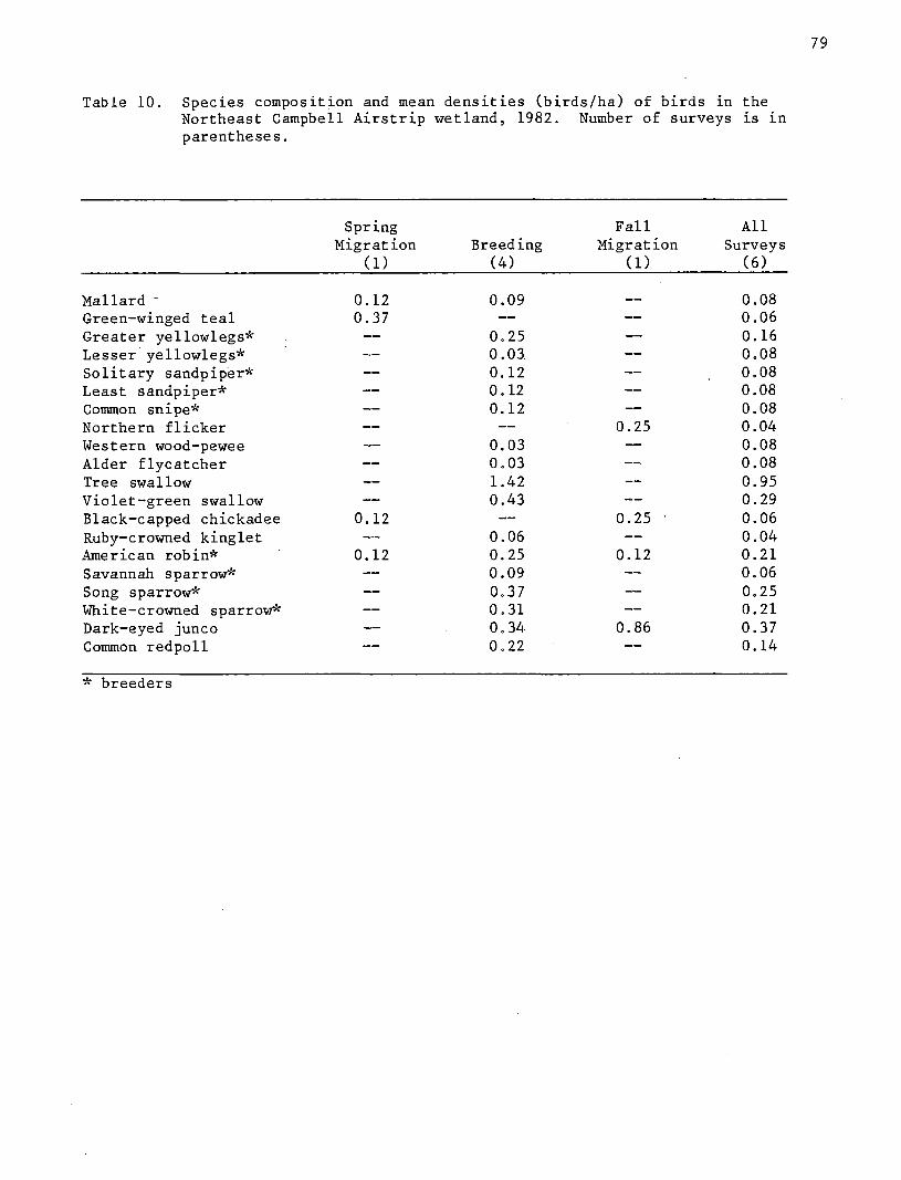
Table 10. Species composLtLon and mean densities (birds/ha) of birds in the Northeast Campbell Airstrip wetland, 1982. Number of surveys Ls Ln parentheses.
Spring Fall All Migration Breeding Migration Surveys
(1) (4) (1) (6)
Mallard - 0.12 0.09 0.08 Green-winged teal 0.37 0.06 Greater yellowlegs* 0.25 0.16 Lesser yellowlegs* 0.03 0.08 Solitary sandpiper* 0.12 0.08 Least sandpiper* 0.12 0.08 Common snipe* 0.12 0.08 Northern flicker 0.25 0.04 Western wood-pewee 0.03 0.08 Alder flycatcher 0.03 0.08 Tree swallow 1.42 0.95 Violet-green swallow 0.43 0.29 Black-capped chickadee 0.12 0.25 0.06 Ruby-crowned kinglet 0.06 0.04 American robin* 0.12 0.25 0.12 0.21 Savannah sparrow* 0.09 0.06 Song sparrow* 0.37 0.25 White-crowned sparrow* 0.31 0.21 Dark-eyed junco 0.34 0.86 0.37 Common redpoll 0.22 0.14
* breeders
79

Spring Migration - Northeast Campbell Airstrip
Species richness and BSD in the spring were similar to those of the
nearby East Campbell Airstrip wetland, but each wetland was used by
completely different species. Northeast Campbell Airstrip wetland had a
shallow water area that was ice-free by 7 May and mallards and green-winged
teal used it in the spring (Vegetation Type 13c). Green-winged teal and
black-capped chickadees were unique to this season.
Breeding Season - Northeast Campbell Airstrip
A total of 17 species were recorded during summer surveys and at least
n~ne of these bred on the study area. Although swallows were abundant
during this period, they were only recorded on two surveys and were not
breeding in the immediate study area. Fourteen species were observed only
during the breeding season (Table 10). Swallows and sparrows were the most
abundant species.
Fall Migration - Northeast Campbell Airstrip
Robins and dark-eyed juncos were the only spec~es still pre.sent during
fall surveys. Only four spec~es were observed in the fall and all were
passer~nes.
North Fork of Campbell Creek (#40),
Description
Area #40 ~s similar to Campbell Creek Marsh #19. It is a complex of
peat bog and swamp wetland types along feeder streams of Campbell Creek.
Drainage is northwest and west to the ma~n stream course. Streams and
80

wetland vegetation occur between high. well-drained eskers oriented northeast
to southwest (Figure 17). The wetland was designated a Type 2,
Non-patterned Elongated Complex in the· interim Anchorage wetlands study
(Ertec Northwest 1980). It is within the Bicentennial Park boundary but has
been identified in the Park Plan as an area for public facilities and active
recreation.
Alder-willow shrub swamp and beaver-modified bog vegetation types are
very extensive. The nor.th part of the area has many 1 m high beaver dams,
old channels and old beaver pond areas that have been revegetated by
willows, sedges and bluejoint grass since the beaver were removed
(Plate 20). Use of this wetlan~ by moose is very high, particularily w the
willow-dominated vegetation types in the north half of the area.
Natural drainage has not been altered; however, a number of old army
tank trails cut through the area and remain disturbed by ATV activity.
Bird Censuses
Two bird transects, paralleling the North Fork of Campbell Creek at
distances of 35 m and 105 m, were walked by two observers during all
surveys. The combined area of the transects was 15.5 ha (38.6 A) or 9.1
percent of the mapped area (Figure 17).
Species richness for the entire study period was 21 species (Table 11).
Passerines made up 84 percent of the seasonal population. Four species of
waterfowl used the wetland, even though there were no open water areas
except Campbell Creek.
Mean density was 1.65 birds/ha, making it one of the sparsest bird
communities surveyed (Figure 7). Song sparrows and white-crowned sparrows
had the greatest densities.
81
---cuiiiiMt -·-·-·- Drallillp Dltetl
D Olmlrbed Da Dnolopad
~IIUI!IIIMK' 111112 Danlolltnont'
lJII' iljollmd ...... .
t Clloaed Naadlal .. f Poraat
I ODen Naoclleleaf Forad
S Cloaod llroadloaf Foroat
4 BroadiHf Woocllalld
1 Cloaad lloftllad F«aat
C11 NMCIIMaf Woadlllnd
7 DWirf TrN 8cirul!l Woodtand
IJ ODIIII Dwarf Tr• 8orub
I Cfoaad Tal 8111'111t 8ctn1b a Allier
It~~-
tO '&IIIII tall Sllrull 8ctn1b .............. .,_
LEGEND
i t OIHift Law 8tlrll$ lcnll9· lila ......... ..._ ... b lUll-• .... _.,.._ ...
Ci lrilllll- ..................... _ ... d ................... ,._ I ~~-IIPI..-111 i o.>crf ln--.- • ..._ • ....,_ a.t fl ... ICit!l ............... - ... fl c~r ... ., ... ,, .... ., .. ",.._..,_ , .. _ ... I Wlloia ........... ••-•lee I ..... ..., ...
tl2 Opefl Dwarf Slnb Sorub !lriii&OI!!IIell_.....,... ...
tS Wit Gnllllnold Hlrlleoe-11 ... , ........................... _ .. ,
II Sorilorilllo tow...,l'!eol-'aw 11•••-Ci SlrlldMffe Lcale,..Salfl-•• ...... 1111t1n d _,,.. ............. .,_ .......... ..
14 Bryold MCIIII !iret.llleoil
tl l!nlhlltfi' Aquatlo Herbacooua ,_ u.
OW 0Jml Water
Figure 17. Vegetation map of North Fork of Campbell Creek wetland (#40).
82

Table 11. Species composition and mean densities (birds/ha) of birds in the North Fork of Campbell Creek wetland, 1982. Number of surveys is ~n parentheses.
Spring Fall All Migration Breeding Migration Surveys
(1) (4) (1) (6)
Mallard* 0.06 0.05 0.04 Pintail 0.02 0.01 Green-winged teal* 0.13 0.03 0.04 American wigeon* 0.02 0.01 Lesser yellowlegs* 0.05 0.03 Least sandpiper* 0.03 0.02 Common snipe* 0.16 O.ll Belted kingfisher 0.06 0.01 Alder flycatcher 0.08 0.05 Violet-green swallow 0.15 0.10 Gray jay 0.06 0.01 Black-capped chickadee 0.13 0.02 Ruby-crowned kinglet 0. OS . 0.03 American robin* 0.15 0.10 Yellow-rumped warbler 0.26 0.03 0.06 Song sparrow* 0.65 0.43 White-crowned sparrow* 0.47 0.19 0.34 Dark-eyed junco* 0.08 0.05 Rusty blackbird* 0.05 0.03 White-winged crossbill* 0.13 0.09 Pine siskin 0.06 0.04
* breeders
83

Spring Migration
Bird density ~n the spring was low (Figure 7). Only four species were
recorded on the spr~ng surveys resulting ~n a low BSD index (Figure 6,
Appendix F). Mallards and green-winged teal used the creek and tributaries
for feeding and resting. Yellow-rumped warblers were observed in flocks
migrating along the creek as early as 7 May. Black-capped chickadees were
the only other species observed in the spring and they were not seen again
in this wetland during the field season.
Breeding Season
Species richness for the breeding season was 18 and at least 11 of
these species bred in the area (Table 11). All 18 species are known
breeders in the Anchorage bowl and iS is possible that the number of
breeding species was higher. A mallard nest and a w~geon nest were found,
and a green-winged teal brood was sighted near the creek.
Numerous song sparrows and white-crowned sparrows contributed to the
higher breeding season density (Figure 7). Species observed only during
this period included pintails, w~geon, lesser yellowlegs, least sandpipers,
common sn~pe, alder flycatchers, violet-green swallows, ruby-crowned
kinglets, robins, song sparrows, dark-eyed juncos, rusty blackbirds,
white-winged crossbills and pine siskins.
Fall Migration
The fall migration period was a very quiet time on this wetland. Most
birds had departed by mid-August. White-crowned sparrows were the only
birds seen on both the breeding season and fall surveys. The only other
species recorded in the fall were belted kingfisher and gray jay.
84

Tudor Road Bogs (#42)
Descr ion
Tudor Road Bogs are a series of wetlands along the south side of
Tudor Road between Stuckagain Heights Road and the Municipality Offices
(Figure 1). The eastern-most portion of the wetland was chosen for bird
surveys. The entire wetland is within the Bicentennial Park and has
preservation status (AWMP).
The bird study area is a narrow band of closed conifer forest and dwarf
tree scrub woodland bordering a small stream (Figure 14). A stream starts
from seeps and springs and flows north disappearing under Tudor Road. A
municipal snow dump site drains into the wetland from the east. During the
spring snow-melt period, oil and other contaminants were observed running
off the site into the wetland via a bulldozer trail.
Tudor Road Bogs to the west support a variety of forested bog and open
low shrub types. Portions of these wetlands and associated lands between
the Municipal Buildings and Boniface Parkway burned in the recent past and
have since only partially regenerated. Low shrub types occur over a
well-drained deep (>1 m) sphagnum peat. ·An alder closed, tall shrub type
borders the esker south of the power substation. It has no peat
accumulation and only a 5 em litter layer over a well-drained upland forest
soil. East of the esker, bog vegetation occurs on 35 em of peat over a
semipermeable, gravelly sand.. Drainage of this bog and other wetlands to
the west is south towards Campbell Creek.
Bird Censuses
The total area of the wetland surveyed for birds was 3.1 ha (7.7 A).
The survey plot extended from the mouth of the spring to Tudor Road.
Species richness for this bog was the lowest of any wetland surveyed
85

I I I I I n I I m
(Figure 5). Only 14 bird spec~es were recorded throughout the field season
(Table 12), producing a low BSD index. Common snipe were the only
non-passerine birds using the area. Flocks of redpolls and juncos
contributed to the high average density rating for the area.
Spring Migration
Trips were made to Tudor Road Bog on 20 April and 7 May. In April, the
vegetation was still ice and snow covered. No birds were observed on either
survey.
Breeding Season
Thirteen species were observed during the breeding season and all may
have been breeding there (Table 12). Species found in the highest densities
were redpolls, juncos, white-winged crossbills and ruby-crowned kinglets.
These species probably occurred in this wetland as visitors from their
surrounding preferred habitat in the spruce and birch forest edge.
Fall Migration
The density of birds for this wetland was high compared to other study
areas during fall (Figure 7), mostly because of migrating black-capped
chickadees, boreal chickadees, juncos and redpolls. A total of nine species
were recorded in the fall; all but the common snipe were passerines.
86

I I I I I
I I I II I
II I II I I
Table 12. Species composition and mean densities (birds/ha) of birds in the Tudor Road Bog, 1982. Number of surveys is in parentheses.
Common snipe Alder flycatcher Black-capped chickadee Boreal chickadee Ruby-crowned kinglet Swainson's thrush Orange-crowned warbler Yellow-rumped warbler Song sparrow White-crowned sparrow Dark-eyed junco -Rusty blackbird White-winged crossbill Common redpoll
Spring Migration
(1) Breeding
(4)
0.22 O.ll O.ll
0.54 0.22 0.43 0.97 0.21 0.42 0.97 0.32 0.54 0.97
Fall Migration
(1)
0.32 0.16 0.13' 0.81
0.16 0.65 0.97
0.32 3.23
All Surveys·
(6)
0.18 0.09 0.37 0.23 0.23 0.09 0.18 0.28 0.14 0.60 0.69 0.14 0.32 1.34
87

I I I I I I D
I I I . I
Baxter Bog (#44)
Description
Baxter Bog was classified as a Type 2 wetland, Non-patterned Elongated
Complex in the interim Anchorage wetland study (Ertec Northwest 1980). It
is a basin bog covered by open, low shrub scrub and needleleaf woodland
vegetation (Figure 18). Baxter Bog Park, in the west half of the wetland,
is in preservation status. It contains Baxter Lake, a long (350m), narrow
(150m) shallow ((4 m) bog lake. A north-south esker occurred in the east
half of the area and was covered by upland birch forest. This eastern
portion was designated conservation status "in order to preserve the
hydrologic integrity of the bog" (AWMP). However, the north half of the
east side of the wetland was excavated and filled during the summer of 1982
before this study was completed. Baxter Bog is surrounded by residential
development and a number of filled areas extend into the wetland on the
east, south and west sides.
Drainage is north-northeast but has been interrupted by a sewerline
extension and drainage ditches through the center of the area. The west
half has remained saturated, but the east half supports a drier flora and
the sphagnum/feathermoss peat is not saturated.
Bird Censuses
We divided Baxter Bog into east and west plots separated by the
sewerline extension in the center of the study area (Figure 18). The west
or park plot was 9.9 ha (24;9 A). The east plot was parallel to the park
plot and approximately the same size at 8.7 ha (21.8 A). However, after
development began in the middle of June, the east section became a plot of
4.1 ha (10.3 A).· Census results are a combination of the west and east
plots excluding the developed area on the east side, or a total of 14 ha.
88

== ==
---Cutllne -·-·-·- Dr1111Mge Ditch
D Dlaturbed De Developed
~Summer 1lil82 Dovalopmanf
UF Upland Forut
1. Cloaad Ne~tdlaleaf Forest
2 Open Nuedleleaf For11et
3 Cloaed Broadleef Foreat
4 Broadlaaf Woodland
5 Cloead Mixed Fore•t
6 Needllllllaf Woodland
7 Dwarf Tree Scrub Woodlalld
8 Open Dwarf Trse Scrub
9 Cloaed Tall Shrub Scrub 8 Alclllr Wllaw
b Alclar
10 ·open Tall Sllrub Scrub a &llr'ub &.,11 ....
b lUcier
= ==
LEGEND
11 Opan Low Shrub Scrub a 3"eetaaa-Bpllaanua Baa.
b Edaaoeaue SIVub-Bph!llliU!• Bag
a Erla!IGeaua SIVulli-Beclga-Bpllegnua Bag
d Swealgale Saclge Fen
• Clllquelalt-llphaanua Boa
f Dwarf lllralt-Erlaeaeoua Shrulli-Bphaa- Baa
g lliwHtgaa-Saclga-Fen Maac Fen
II Clllquelolt-Sweetgale-Erlaaaeeualllllrulll
l'eatllaraaaa lilag
Wlllaw•Biualalnt Cllraaa llloaa lllog
Low Wlllew ••a
11 Open Dwarf Shrub Scrub Elteaaeeua llllrult-llplla@l*a IJag
13 Wet Gramlnold H11rbaceoua a Iliaci;. Tu!laaoii·Miaacl lllrulll-llpllaanua lllog
b llubaraUa lawlelld-Sedga-lilag Maacloar
. a lu~nrotlo lawle!lct-Seclga-Moge-!iag Maaclaw
d lllull11rat1a Lawlancl-8aclgo-Wet Meada"
14 Bryold Maa11 Wat Maeo
~ ri F;Qsstllwager Aquatic Herbac11oua Panel Lily
OW Op&n Wst8f
Figure 18. Vegetation map of Baxter Bog (#44).
..: Q ... II -)( IS m
-·J-
De
Northern Lights Blvd:
Tudo.r Rd.
iiiiii
-a a: c: 0 • ... II .. .. Ill
Q..
Photo 3-16
iiii
OJ \0

I I I I I
A total of 37 species were sighted throughout the field season
(Table 13). Species richness was greatest during the breeding season
(Figure 5, Appendix E).
Although final results are combined for both the west and east plots,
records were kept separately on each area .. An analysis showed that the
number of birds on each area was nearly equal. Fifty-five percent of all
birds were counted o~ the park plot, but because the park plot was larger,
densities are actually greater on the east side. The average on the park
side was 4.38 birds/ha and 7.77 birds/acres on the east plot. Species
richness was similar for both plots. More waterfowl were recorded on the
park side where Baxter Lake attracted migrating and breeding waterfowl.
Spring Migration
The.majority of birds recorded in the spring were waterfowl. Canada
geese, wigeon, pintail and bufflehead were observed only on the park plot in
the vicinity of the lak~. Mallards and green-winged teal used water ditches
on the east plot as well as the lake on the park plot.
Bird species diversity (15 species) was lowest in the spr~ng
(Figure 6). During spring, this was the only study area to host
buffleheads. Turnagain had the only other wigeon and only Lake Otis had
dowitchers.
Breeding Season
As in other areas, species richness was greatest during the breeding
season (Figure 5). Of the 31 species recorded, at least 17 were breeding on
Baxter Bog (Table 13). Two mallard, two green-winged .teal and a goldeneye
brood were seen in June and July. The goldeneyes stayed on the lake
throughout the breeding season but the mallards and green-winged teal used
both the lake and ditches on the east side for brood rearing.
90

I I I n I I I
Table 13. Species composition and mean densities (birds/ha) of birds 1n Baxter Bog, 1982. Number of surveys is in parentheses.
Spring Fall All Migration Breeding Migration Surveys
(2) (4) (2) (8)
Red-necked grebe 0.04 0.01 Horned grebe 0.04 0.09 0.05 Canada goose 0.14 O.ll 0.05 Mallard* 0.61 0.41 0.36 0.44 Pintail O.ll 0.07 0.06 Green-winged teal* 0.43 0.20 0.21 0.26 American wigeon 0.07 0.02 Common goldeneye* --2 0.18 0.36 0.18 Greater scaup 0.04 0.02 Bufflehead 0.07 0.02 Semipalmated plover 0.02 0.04 0.02 Lesser yellowlegs* 0.32 0.04 0.17 Solitary sandpiper* O.ll 0.04 0.04 Whimbrel 0.01 0.03 0.02 Western sandpiper <O.Ol <O.Ol Least sandpiper* 0.11 0.06 Pectoral sandpiper 0.04 0.02 Dowitcher spp. 0.11 0.03 Common snipe* 0.36 0.64 0.43 0.52 Red-necked phalarope 0.04 0.02 Unidentified sandpiper 0.05 0.03 Mew gull 0.25 0.09 0.11 Northern flicker 0.02 0.01 Western wood-pewee 0.02 0.01 Olive-sided flycatcher 0.04 0.02 Alder flycatcher 0.20 0.11 0.12 Tree swallow* 0.18 0.86 0.25 0.54 Violet-green swallow* 0.68 0.11 0.37 Cliff swallow 0.16 0.08 Black-billed magpie 0.07 0.24 American robin* 0.39 0.18 0.24 Bohemian waxwing 0.02 0.18 0.01 Tree sparrow* 0.27 0.13 Savannah sparrow* 0.02 0.11 0.04 Song sparrow* 0.15 0.21 0.21 Lincoln sparrow 0.02 0.01 White-crowned sparrow* 0.07 1.16 0.57 0. 74 Dark-eyed junco* 0.07 0.02 O.ll 0.05 Rusty blackbird* 0.04 0.50 0.29 0.33 Common redpoll 0.141 0.04
* breeders
91

I -
I I I I u n I I
Species with the highest densities included least sandpipers, common
snipes, violet-green and tree swallows and white-crowned sparrows. Species
·occurring only in the breeding season were red-necked phalaropes,
olive-sided flycatchers, tree sparrows, Lincoln's sparrows, northern
flickers and wood pewees.
Fall Migration
Baxter Bog had the highest fall BSD rating of all study areas
(Figure 6, Appendix F). Species richness was second only to Connors Bog
(Figure 5, Appendix E). Mallard and green-winged teal broods contributed to
the high fall densities. Species unique to this period were red-necked
grebes, black-billed magpies and common redpolls.
DISCUSSION
Wetland Types and Bird Use
The eleven wetlands chosen for study were classified ~n the "Anchorage
Wetlands Study: Mapping and Classification of Freshwater Wetlands" (Ertec
Northwest 1980). We used this classification scheme to select wetlands
representive of four types (Table 1) for comparison of biological values
among types. Our final conclusion is that individual wetlands within AWMP
types are so varied in terms of vegetation patterns and bird communities
that it is difficult to use the classification to identify units of
high-value bird habitat or unique vegetation assemblages. Our observations
on each type are therefore general.
92

I II I I I g
Type 1, Patterned Open Complex, is described as a large blanketing bog
with no obvious basin (Ertec Northwest 1980). Within this type, we surveyed
Klatt, Connors and Turnagain Bogs. These areas had a low to moderate
diversity of vegetation types as compared to other wetlands surveyed. All
three, however, possessed numerous small and large water bodies and
strangmoor, making them attractive waterfowl and shorebird habitat. 1The
larger water bodies include Strawberry and Connors Lakes in Connors Bog and
a bog lake in Turnagain Bog. Between the two major lakes in Connors Bog
there LS extensive strangmoor vegetation including many shallow flarks that
are flooded into late summer. Klatt Bog lacks any large water body but does
possess strangmoor with numerous, deep, permanently flooded small ponds
(flarks). Klatt Bog strangmoor is not as extensive as that in Connors Bog
or as diverse in its vegetation types (Table 2). Strangmoor Ln Turnagain
Bog is moderately extensive but only seasonally flooded.
Connors, Klatt and Turnagain Bogs had the greatest bird specLes
richness among all wetlands studied (Figure 5). Species richness was
especially high during the breeding season. Waterfowl were more abundant
and diverse on Type 1 wetlands than on any other type surveyed. Although
species richness and BSD for these wetlands were similar (Figures 5, 6),
bird densities were not. Connors Bog consistently had notably higher
densities for each season than either Klatt or Turnagain Bogs (Figure 7).
Higher bird use in Type 1 wetlands may be attributed to the increased
availability of open water and interspersed strangmoor vegetation types in
these areas. Different amounts of open water and strangmoor between
Connors, Klatt and Turnagain Bogs may help explain differential bird use
within this type.
93

94
The bird use of Connors Bog may also be higher because of lowered water
levels of Strawberry and Connors Lakes. Bog lakes normally have an abrupt
margin with littl:e or no emergent vegetation. Strawberry and Connors Lakes
are characterized by emergent vegetation types that offer more feeding,
escape and brood rearing habitat for waterbirds than all other bog lakes
surveyed in the Anchorage Bowl.
Type 2 wetlands, Non-patterned Elongated Complex, are slightly sloping
bogs, located within a stream or glacial valley, and have an inlet or outlet
stream (Ertec Northwest 1980). The Type 2 wetlands we studied were Baxter
Bog, Campbell Creek Marsh, North Fork of Campbell Creek and Tudor Road Bogs.
All four are characterized by relatively few vegetation types. Baxter Bog
has one small pond and a moderately large lake; Campbell Creek courses
through the other wetlands.
These areas were different from each other in many characteristics
(e.g. depth to water table, vegetation types) which was reflected by
dissimilar bird communities, species richness and densities (Figures 5,6,7).
Baxter Bog with its lake and pond, was used by migrating and breeding
waterfowl, but other Type 2 wetlands had predominantly passerine
' communities. The latter areas are covered by low shrub and woodland
vegetation types. This contributed to higher spring and breeding densities
for Baxter Bog and raised the overall average for the type. Baxter Bog was
one of the most productive wetlands based on species richness, bird density
and bird species diversity. The other three Type 2 wetlands tended to be on
the lower end of the scale (Figures 5,6,7).
The North Fork of Campbell Creek and Tudor Road Bogs had very little
bird use in the spring. These two wetlands attracted mostly passerines,
which were not abundant during the spring survey period. These wetlands are
higher in elevation than any of the Type 1 wetlands and still had snow

patches and frozen water areas during the spr~ng. Few migrant
passerines arrived before bare patches of ground appeared. Strictly
insectivorous species generally d9 not arrive until near the end of May. An
abundant passerine population raised the breeding and fall densities for
Tudor Road Bogs but BSD was not as high as the other Type 2 wetlands.
Type 3 wetlands are Lakeside Complexes, described as flat bogs
bordering lakes (Ertec Northwest 1980). The two Type 3 wetlands surveyed
were DeLong Lake and Lake Otis. These two wetlands were small in area but
had the highest bird densities of any wetlands studied (Figure 7). They had
diverse populations of waterfowl, shorebirds and passerines. Species
richness and BSD were similar for all wetlands studied but it was in their
densities that the lakeside. wetlands were most impressive (Figure 19). They
averaged 13.33 birds/ha for the 1982 season (Table 14).
The lakeside bogs illustrate an important consideration ~n evaluating
wetlands. In the Ertec Northwest (1980) report, wetlands were evaluated
with a rating system. One of the critera for value to birds was wetland
surface area: the larger the area, the higher the rating. The rationale
for this rating was: "area is important because larger areas can generally
accommodate larger populations of animals" (p. 14). We did not find this to
be the case with our study sites.
Bird density for DeLong Lake and Lake Otis was two and three times
greater, respectively, than all other wetlands surveyed. Klatt Bog had
twice as many birds as Lake Otis but was 34 times the size of the Lake Otis
study area. Therefore, comparing densities, BSD and species richness of
Lake Otis wetland with any other wetlands shows how rich a·small wetland can
be and that many qualitative factors in the habitat may be more important
than size.
95

3·~:::-------------------------rl « f.~ :::: '::;'
2· f }~2 .·.· a".•
.. .:·: ... ::::·::.:::~1 :::::
:= .. ·::':::.:.:::~::. ::::: 1-~ jr
40~------------------------~~40
. 30
20
10
20--------------------------~20
96
SPECIES DIVERSITY
SPECIES RICHNESS
DENSITY 10 (Birds/ha)
1 2 3 7 WETLAND TYPE
Figure 19. Bird species diversity, richness and density (birds/ha) from four wetland types (AWMP).

97
Table 14. Comparison of wetland bird population estimates for four different wetland types* in the Anchorage Bowl.
Type 1 Type 2 Type 3 Type 7
Density (birds/ha) 2.57 3.07 13.33 2.46
Species Richness 42 25 24.5 24
Species Diversity 2.96 2.59 2.52 2. 71
* from AWMP

The Type 7 wetlands, Nonforested Closed Bog, are small, simple, closed
basins which may have surface pattern or central pools (Ertec Northwest
1980). East Campbell Airstrip and Northeast Campbell Airstrip, in
Bicentennial Park, were classified as Type 7. These wetlands occupy basin-
like depressions between eskers. East Campbell Airstrip has two small lakes
(Basher Lakes) surrounded by a floating bog mat much like Lake Otis and
DeLong Lake.
East Campbell Airstrip had the highest bird species diversity for any
wetland (Figure 6). This was because there were many species during the
breeding season and their numbers were evenly distributed. Species richness
for Type 7 wetlands was not as high as Type 1 wetiands but densities,
especially during the breeding season, were comparable (Figure 19). These
Type 7 wetlands were in the Chugach Mountain foothills where colder spr~ng
and fall temperatures may have affected species composition and numbers on a
seasonal basis.
Recommendations
Connors Bogl
The AWMP (1982) placed the Connors Bog study area ~n the preservation
category with the exception of areas A and B (Figure 4), which were part of
a developable category.
1 An earlier report (Hogan and Tande 1982) presented data collected in Connors Bog and Campbell/Klatt Bog in order to meet a request for information by 1 November 1982. An edited version of this preliminary report's discussion and management recommendations appears here with minor rev~s~ons. These changes incorporate the new vegetation classification and allow for comparisons to be made between all individual wetlands and wetland types discussed in the present report.
98

Connors Bog well deserves preservation status. Although its drainage
and vegetation communities have been altered by roads and drainage ditches,
it is still a fairly intact example of the patterned open complex bog.
Several sections of Connors Bog show the string bog pattern, having more or
less parallel -bog ridges, separated by wet hollows. One of the most
important features of Connors Bog is the presence of two open water bodies,
Connors Lake and Strawberry Lake. These lakes contribute to the
attractiveness of the area to waterfowl and shorebirds. Open water areas
are important to waterfowl for resting, feeding and breeding habitat and
especially brood habitat. These lakes probably account for the higher bird
densities and diversity at Connors Bog than at nearby Klatt Bog, which
contains similar vegetation types and patterns (Figures 3,8).
Bird species richness was higher in Connors Bog than any other study
wetland in Anchorage. At least 30 species of birds breed there including
arctic loons, red-necked grebes, Canada geese, mallards, wigeon, pintails,
green-winged teal, shovelers and greater scaup.
We recommend that every effort be made to retain the preservation
status of Connors Bog. This may involve either acquisition or easements on
private lands in the northeast corner of the bog.
Connors Bog has potential as a recreational area for the grow1ng
neighborhoods in this part of town. We recommend non-disruptive activities
during spr1ng and summer and that intensive recreational use be limited to
winter activities for minimum impact to wildlife and the wetlands. The
northern half of Connors Bog is presently used as a snow machine
recreation area, which has had little negative impact on the wetland.
99

All motorized recreational vehicles should be discouraged during the
spring and summer when bird densities are highest and nesting birds are.
using the area. Dirt bikes and other motorized recreational vehicles have
already caused considerable damage to wetland vegetation, especially in the
spring when the ground was still frozen and protective snow cover was gone.
We recommend that any further plans for road development in this area
avoid or skirt the wetlands. Culverts should be used to prevent any pooling
of water ~n the bog, similar to the situation caused by the diagonal road
through the north half of the area (Figure 3).
Areas A and B (F{gure 4) around Strawberry Lake are Qeing considered
for development. We recommend that these areas not be developed. These
areas are drier than the rest of the bog because of the drainage ditches
immediately south of these parcels. Pl'ots A and B contained water only in
the spring, and thereafter had very limited bird use. Although they are
drier habitat with little value to birds we feel that they are important to
the integritJ of Strawberry Lake which is 1) a un~que marsh habitat in the
Anchorage Wetlands complexes; 2) a significant habitat for migrating and
breeding waterfowl and shorebirds; and 3) provides the important element of
open water to make Connors Bog more attractive as a whole to these birds.
Vegetation patterns around the perimeter of Strawberry Lake show that
the waterline has gradually receded. We feel that this has occurred because
of the drainage ditches to the south. Development of plots A and B would
involve peat removal and replacement with gravel. There is the possibility
that the conversion of peat to gravel would create an aquifer draining more
water from this section of Connors Bog, further lowering the water level of
Strawberry Lake. Engineering and hydrological studies should explore the
possibility of preventing this problem, perhaps by sealing fill interfaces,
before any development is allowed in areas A and B.
100

If development proceeds in the vicinity of Strawberry Lake we recommend
a 100-m (300-ft) setback around Strawberry Lake. The buffer zone around
the lake should, at ·the very least, include the black spruce forest margin
(Type 2, Figure 3) that crea~es a natural visual barrier for wildlife,
recreationists and potential homeowners .
. Turnagain ~og
Turnagain Bog ~s currently classified as a preservation wetland and
this status should be continued. It has a moderately high diversity of
vegetation types with a large bog lake and strangmoor which was heavily
utilized by waterbirds. The north half of the area is less important for
birds than the south half where Turnagain Bog Lake is located. The north
half, however, was used by nesting geese and feeding ducks. The area has
high habitat value but low recreational potential due to its proximity to
Anchorage International Airport and high noise levels.
DeLong Lake
DeLong Lake is a lakeside bog with high ·habitat diversity and bird use.
Its status as a preservation wetland should be continued. One of its most
.important features is the presence of DeLong Lake and a small bog pond which
serve as important habitat for water birds. Shorebirds make extensive use
of bog vegetation types during spr~ng migration and summer breeding periods.
The study area as a whole complements DeLong Lake Park at the east end of
the lake and is important as open space for the surrounding residential
community. Summer use of the area by ATV's should be stopped as they have
left rutted trails across this peatland.
101

Campbell Tract Wetlands
Campbell Creek Marsh, East Campbell Airstrip, Northeast Campbell
Airstrip, North Fork of Campbell Creek and Tudor Road wetlands are within
the Bicentennial Park boundary. These areas, for the most part, are already
in preservation status. Tudor Road Bog and a p6rtion of the North Fork of
Campbell Creek wetland have been designated as special study wetlands until
conflicts between wetlands regulations and the existing park plan are
resolved (AWMP 1982).
All Campbell Tract wetlands had a low diversity of vegetation types and
low bird use. However, the North Fork of Campbell Creek wetland, especially
the portion designated special study near Tudor Road, is important for moose
feeding habitat. This was the only wetland surveyed with extensive willow
vegetation types offering moose preferred winter browse not common
elsewhere.
We recommend that Bicentennial Park facilities being planned for this
area be moved to areas further west along Tudor Road. We also recommend
that current drainage of the Municipality snow dump site into the east
portion of Tudor Road Bog be corrected. At present, oil, salt and other
pollutants enter this wetland via a bulldozed trail during the sprLng
snow-melt period.
Lake Otis
Lake Otis wetland has been designated for development by the AWMP
(1982). This area had a high diversity of habitat types for its size and
had the highest bird densities of all wetlands surveyed in 1982 (Figure 7).
We therefore recommend that this area be considered for preservation status.
102

The area not only supports a high bird use, but may also be important in
maintaining the hydrological integrity of Lake Otis and as open space ~n an
already densely populated residential area.
Baxter Bog
The west half of Baxter Bog (Baxter Bog Park) is a preservation
wetland. The east half has been designated conservation in order to
preserve the hydrological integrity of the bog (AWMP). According to the
definition of a "conservation" wetland, 11 the.key to this classification is
the management of the area to maintain the natural wetlands integrity ~nd
intrinsic wetland functions, as much as practicable, while allowing certain
carefully controlled use to occur."
While this study was being conducted, development began on the north
half of the por~ion of Baxter Bog designated as a conservation wetland. We
recommend that no further development be allowed to take place until it ~s
determined how much reserved land is needed to protect the hydrological
function of Baxter Bog Park.
Campbell/Klatt Bogl
Approximately 360 ha (890 A) of Klatt Bog are in Corps of Engineers
jurisdiction for individual wetland permits (Figure 9). Under the Anchorage
Wetlands Management Plan, Klatt Bog is classified as a conservation wetland.
Our recommendations are geared toward maintaining the most valuable sections
of Klatt Bog.
Klatt Bog was one of three 11pattern~d open complex11 wetlands that we
studied in the Anchorage Bowl. Compared to the Connors Bog and Turnagain
Bog study areas, Klatt Bog showed more disturbed vegetation patterns and low
1 see footnote, page 98.
103

104
values for bird density, diversity and species richness. An important
factor in· comparing bird use is that unlike Turnagain or Connors Bogs, there
are no large open bodies of water in Klatt Bog.
Drainage ditches have altered the south half of Klatt Bog where ponded
wetland types were at one time more prevalent. North of the drainage
ditches there are good examples of the original, natural surface patterns in
the forni of bog ridges (strangs) and wet hollows (flarks). It is these
areas that we strongly recommend for preservation (Figure 20).
We recommend that every effort be made to preserve the 23 ha (57 A) of
strangmoor outlined (A) in Figure 20. Few undisturbed examples of string ..
bogs are left in the Anchorage Bowl, which gives Klatt Bog intrinsic
biological value. This area was the most attractive to birds in terms of
density and species richness. We also recommend that preservation status be
considered for the ponded area outlined (B) south of the strangs and flarks
(Figure 20) .
Drier habitat outside areas A and B shows ngns of drainage and
disturbance. Of the 360 ha (890 A) presently under Corps of Engineers'
individual permit jurisdiction, we recommend that 46 ha (115 A, 13 percent)
be considered for preservation. We stress that preservation includes more
than merely leaving 46 ha (115 A) untouched while development occurs around
it. Further hydrological studies may be needed in order to preserve the
integrity of these areas as wetlands, not just as open space.

105
Figure 20. Areas recommended for preservation in Klatt Bog.

106
ACKNOWLEDGEMENTS
We would like to acknowledge the voluntary field assistance of
C. Anderson, M. Johnson and K. Timm. Special thanks are extended to
Marianne G. See, Bureau of Land Management, for advice and assistance with
the vegetation analysis and Laurel Wheeler for the typing and final report
preparations. We would also like to acknowledge Keith Bayha for reviewing
the preliminary draft, and Jon Hall, Jon Nickles, Wayne Pichon and Torn Rothe
for review of the final report. Jon Nickles (WAES) and Torn Rothe (Special
Studies) provided support and assistance throughout the study.

LITERATURE CITED
American Ornithologists' Union. 1982. Thirty-fourth supplement to the
American Ornithologists' Union checklist of North American birds.
Auk 99(2):suppl.
Boelter, D.H. and E.S. Verry. 1977. Peatland and water in the
northern lake states. USDA, For. Serv. N. Central For. Exp. Sta.
St. Paul, MN. Tech. Rept. NC-31.
Conner, R.N. and J.G. Dickson. 1980. Strip transect sampling and
analysis for avian habitat studies. Wildl. Soc. Bull. 90:
19-30.
Cowardin, L.M., V. Carter, F.C. Golet and E.T. LaRoe. 1979.
Classification of wetlands and deep water habitats of the United
States. USDI- Fish and Wildl. Serv., Washington, D.C. Pub. No.
FWS/OWS-79/31, 103pp.
Crumm, H.A., W.C. Steere and L.E. Anderson. 1973. A new list of
mosses of North America north of Mexico. Bryologist 76: 85-130.
Emlen, J.T. 1971. Population densities of birds derived from transect
counts. Auk 88: 323-342.
Ertec Northwest, Inc. 1980. Anchorage wetlands study: mapping and
classification of freshwater wetlands. Prepared for the
Municipality of Anchorage, Alaska. 3 Vols. 38pp.
107

Hogan, M. and G.F. Tande. 1982. Anchorage wetlands study special
report on Connors Bog and Klatt Bog. Unpubl. Rept. USDI - Fish
and Wildl. Serv., Special Studies, Anchorage, Alaska.
Hulten, E. 1968. Flora of Alaska and neighboring territories.
Stanford Univ. Press, Stanford, CA. 1008 pp.
Jeglum, J'.K., A.N. Boissonneau and V.F. Haavisto. 1974. Toward a
wetland classification for Ontario. Can. For. Serv. Great Lakes
For. Exp. Sta. Sault Ste. Marie, Ont. Inf. Rept. No. 0-X-215.
Mueller-Dombois, D. and H. Ellenberg. 1974. Aims and methods of
vegetation ecology. John Wiley and Sons, NY. 547 pp.
Noble, R.E. and R.B. Hamilton. 1976. Bird ·populations ~n even-aged
loblolly p~ne forests. Louisiana Ag. Exper. Sta. Project No.
1588. 22 pp.
Palmer, R.S., Ed. 1976. Handbook of North American birds. Vol. 2.
Waterfowl (Part 1). Yale Univers·ity Press. New Haven, Conn., and
London.
Shannon, C.E. and W. Weaver. 1949. The mathematical theory of
communication. Univ. of Illinois Press, Urbana. 117pp.
108

Viereck, L.A. and C.T. Dyrness. 1980. A preliminary classification
system for vegetation of Alaska. USDA, For. Serv., Inst. of
Northern Forestry, Pacific N.W. For. and Range Exp. Stn.,
Fairbanks, Gen. Tech. Rept. PWN-106. 38 pp.
Viereck, L.A., C.T. Dyrness and A.R. Batten. 1982. 1982 Revision of
preliminary classification for vegetation of Alaska. USDA, For.
Serv., Inst. of Northern Forestry, Pacific N.W. For. and Range
Exp. Stn., Fairbanks.
Walker, D.A., P.J. Webber and V. Komarkova. 1979. A large scale
(1:6,000) vegetation mapping method for northern Alaska. Unpubl.
Rept. Inst. Arctic and Alpine Research, Plant Ecol. Lab.
Boulder, CO. 48 pp.
Westhoff, V. and E. van der Maarel. 1973. The Braun-Blanquet
approach. pp. 619-726 in R.H. Whittaker, ed. Ordination and
classification of communities. Handbook of vegetation science.
Pt. 5. Dr.W. Junk. B.V. Publ., The Hague.
109
APPENDIX A- Bird species list for Anchorage wetlands, summer 1982.
COMMON NAME
Arctic loon Red-necked grebe Horned grebe Canada goose Mallard Pintail Green-winged teal Northern shoveler American wigeon Greater scaup Bufflehead Bald eagle Northern harrier Sandhill crane Semipalmated plover Killdeer· Greater yellowlegs Lesser yellowlegs Spotted sandpiper Whimbrel Hudsonian godwit Least sandpiper Pectoral sandpiper Short-billed dowitcher Common snipe Red-necked phalarope Mew gull Herring gull Glaucous-winged gull Arctic tern Short-eared owl Common flicker Olive-sided flycatcher Alder flycatcher Say's phoebe Western wood pewee Tree swallow Violet-green swallow Cliff swallow Common raven Northwestern crow Boreal chickadee American robin Ruby-crowned kinglet
SCIENTIFIC NAME
Gavia arctica Podiceps grisegena Podiceps auritus Branta ca~adensis Anas platyrhynchos Anas acuta Anas crecca Anas clypeata Anas americana
. Ayt'hya marila Bucephala albeola Haliaeetus leucocephalus Circus cyaneus Grus canadensis Charadrius semipalmatus Charadrius vociferus Tringa melanoleuca Tringa flavipes Actitis macularia Numenius phaeopus Limosa haemastica Calidris minutilla Calidris melanotos Limnodromus griseus Gallinago gallinago Phalaropus lobatus Larus canus Larus argentatus Larus glaucescens Sterna paradisaea Asia flammeus ~ptes auratus Contopus borealis Empidonax alnorum Sayornis saya Contopus sordidulus Tachycineta bicolor Tachycineta thalassina Hirundo pyrrhonota Corvus corax Corvus caurinus Parus hudsonicus Turdus migratorius Regulus calendula
110

APPENDIX A - continued
COMMON NAME
Bohemian waxwing Yellow-rumped warbler Rusty blackbird Common redpoll Pine siskin Savannah sparrow Dark-eyed junco Tree sparrow White-crowned sparrow Golden-crowned sparrow Song sparrow
SCIENTIFIC NAME
Bombycilla garrulus Dendroica coronata Euphagus carolinus Carduelis flammea Carduelis pinus Passerculus sandwichensis Junco hyemalis Spizella arborea Zonotrichia leucophrys Zonotrichia atricapilla Melospiza melodia
111

112
APPENDIX B - Vascular plants, mosses and lichens collected ~n Anchorage Wetlands, summer 1982.
SCIENTIFIC NAME
VASCULAR PLANTS
Agropyron repens (L.) Beauv. A. smithii Rydb. A. spp. Agrostis scabra Willd~ Alnus tenuifolia Nutt. Andromeda polifolia L. Anemone richardsonnii Hock. A. parviflora Michx. Arctostaphylos rubra (Rehd. & Wilson) Aster junciformis Rydb. Betula glandulosa Michx. B. nana L. B. papyrifera Marsh. subsp. humilis (Regel) Hult. Calamogrostis canadensis (Michx.) Beauv. var. canadensis Carex aquatilis Wahlenb. C. atherodes Spreng. C. buxbaumii Wahlenb. C. canescens L. C. capitata Soland, in L. C._chordorrhiza Ehrh. C. disperma Dew. C. kelloggii W. Boott C. lasiocarpa Ehrh. subsp. amer~cana (Fern.) Hult. C. limosa L. C. livida (Wahlenb.) Willd. C. lyngbyaei Hornem. C. magellanica (Lam.) subsp. irrigua (Wahlenb.)Hult. C. membranacea Hook. C. oederi Retz. subsp. vividula C. pauciflora Lightf. c. phyllomanica W. Boott C. pluriflora Hult. C. rariflora (Wahlenb.) J.E. Sm. C. rhynchophysa C.A. Mey. C. rostrata Stokes C. rotundata Wahlenb. C. sitchensis Prescott C. tenuifolia Wahlenb. Chamaedaphne calyculata (L.) Moench Cornus canadensis L. Cypripedium guttatum Sw. subsp. guttatum Drosera anglica Huds. D. rotundifolia L. Dryopteris dilata (Hoffm.) Gray s.l. Eleocharis palustris (L.) Roem. & Schult. Empetrum nigrum L. subsp. hermaphroditum (Lange) Bacher
COMMON NAME
Quackgrass Western wheat grass
Tickle grass Thinleaf alder Bog rosemary Yellow anemone Northern anemone Bearberry Bog aster Resin birch Dwarf arctic birch Paper birch Bluejoint grass Water sedge Awned sedge Buxbaum sedge Silvery sedge Capitate sedge Creeping sedge Soft-leaved sedge Kellogg sedge Hairy-fruited sedge Shor-e se-dge Livid sedge Lyngbye sedge Bog sedge Fragqe sedge Oeder sedge Few-flowered sedge Stellate· sedge Many flower sedge Rare sedge
Beaked sedge Rotund sedge Sitka sedge Sparse-flowered sedge Leather leaf Bunchberry Spotted lady's slipper Long-leaf sundew Round~leaf sundew Spinulose shield fern Creeping spikerush Crowberry

APPENDIX B - continued
SCIENTIFIC NAME
Epilobium adenocaulon Haussk. E. angustifolium L. subsp. angustifolium E. hornemannii Rchb. E. lactiflorum Haussk. !· palustre L. Equisetum arvense L. E. fluviatile E. silvaticum L. Eriophorum angustifolium Honck. subsp. scabriusculum Hult. E. angustifolium Honck. subsp. subarcticum (Vassiljev) Hult. E. russeolum E. Fries var. albidum Nyl. E. russeolum E. Fries subsp. rufescens (Anders.) Hyl. E. scheuchzeri Hoppe var. scheuchzeri E. scheuchzeri Hoppe var. tenuifolium Ohwi E. viridi-carinatum (Engelm.) Fern. Galium boreale L. Geocaulon lividum (Richards.) Fern. Hammarbya paludosa (L.) Rtze. Hordeum jubatum L. Iris setosa Pall. subsp. setosa ~us alpinus Vill. J. bufonius L. J. castaneus Sm. subsp. castaneus J. oreganus S. Wats. J. stygius subsp. americanus (Buchenau) Hult. Juniperus horizontalis Moench Ledum palustre L. subsp. decumbens (Ait.) Hult. L. palustre L. subsp. groenlandicum (Oeder) Hult. Lemna minor L. Linnaea borealis L. Listera cordata (L.) R.Br. Lycopodium annotinum L. subsp. annotinum Menyanthes trifoliata L. Mimulus guttatus DC. Myrica gale L. Nuphar PQIYsepalum Engelm. Nymphaea tetragona Georgi Oxycoccus microcarpus Turcz. Parnassia palustris L. subsp. neogaea (Fern.) Hult.
Pedicularis capitata Adams P. labradorica Wirsing Picea glauca (Moench.) Voss P. mariana (Mill.) Brett., Sterns & Pogg. Platanthera dilatata (Pursh.) Lindl. P. hyperborea (L.) Lindl. Polemonium acutiflorum Willd.
113
COMMON NAME
Northern willow herb Fireweed Alpine willow herb Alpine willow herb Swamp willow herb Meadow horsetail Swamp horsetail Woodland horsetail Tall cottongrass Tall cottongrass Chamiss cottongrass
White cottongrass White cottongrass Thinleaved cottongrass Northern bedstraw Bastard toadflax Bog adder's tongue Squirreltail grass Blueflag Alpine rush Toad rush Chestnut rush Oregon rush
Creeping juniper Northern labrador tea Labrador tea Pondweed Twinflower Heart-leaved twayblade Stiff clubmoss Buckbean Yellow monkey-flower Sweet gale Yellow waterlily White waterlily Bog cranberry Northern grass-ofparnassus Capitate lousewort Labrador lousewort White spruce Black spruce White bog orchid Northern bog orchid Jacob's ladder

APPENDIX B - continued
SCIENTIFIC NAME
Populus balsamifera L. Potamogeton alpinus subsp. tenuifolius f· epihydrus Raf. var. ramosus (Peck) House f· gramineus L. P. natans L. Potentilla fruticosa L. P. palustris (L.) Scop. Pyrola asarifolia Michx. var. purpurea (Bunge) Fern. P. secunda L. subsp. obtusata (Turcz.) Hult. Ranunculus gmelini DC. subsp. gmelini R. lapponicus L. Rhinanthus minor L. subsp. borealis (Sterneck) Love Ribes triste Pall. Rosa 'acicularis Lindl. RUbUs arcticus L. R. chamaemorus L. 'Jl. pedatus Sm.
~alix barclayi Anderss. ~&. bebbiana Sarg. ~- brachycarpa Nutt. subsp. niphoclada (Rydb.) Argus
S. fuscescens Anderss. 1\ S. glauca L. vfS. lasiandra Beuth. ~~. myrtilifolia Anderss • ..;S. p,lanifolia Pursh subsp. pulchra (Cham.) Argus S. scouleriana Barratt S. spp. Sanguisorba menziesii Rydb. Scirpus validus M.Vahl. Sorbus scopulina Greene Sparganium hyperboreum Least. S. minimum (Hartm.) E. Fries Spiraea beauverdiana Schneid. Spiranthes romanzoffiana Chann. Streptopus amplexifolius (L.) DC. Swertia perennis L. Thalictrum alpinum L. T. sparsiflorum Turcz. Tofieldia coccinea Richards. T. glutinosa (Michx.) Pers. T. pusilla (Michx.) Pers. Trichophorum alpinum (L.) Pers. T. caespitosum (L.) Hartm. Trientalis europaea L. subsp. arcticus (Frsch.) Hult. Trifolium repens L. Triglochin maritimum L. T. palustris L.
114
COMMON NAME
Balsam poplar Northern pondweed Nut tall pondweed
Floating pondweed Shrubby cinquefoil Marsh cinquefoil Liverleaf wintergreen One-sided wintergreen Yellow water crow foot Lapland buttercup Rattlebox American red currant Prickly rose Nagoon berry CloudbeJiry Five-lea.f bramble Barclay; willow Bebb willow Barren-ground willow Alaska bog willow Grayleaf willow Pacific willow Low blueberry willow DiamondleaD willow Scouler willow
'·
Menzies burnet Great bulrush Western mountain ash Northern burreed Small burreed Beauverd's spiraea Ladies' tresses Twisted stalk
Arctic meadowrue Few-flower meadowrue North~rn asphodel
False asphodel
Tufted clubrush Arctic sta~flower White clover Maritime arrowgrass Marsh arrowgrass

Appendix B - continued
SCIENTIFIC NAME
Utricularia intermedia Hayne U. vulgaris L. subsp. macrorhiza (LeConte) Clausen Vaccinium uliginosum L. V. vitis-idaea L. subsp. minus (Lodd.) Hult. Valeriana capitata Pall. Viburnum edule (Michx.) Ra£. Viola episula Ledeb. subsp. repins (Turcz.) Becker V. renifolia Gray var. Brainerdii (Breene) Fern. V. spp.
MOSSES
Aulucomium spp. Dicranum spp. Hylocomium splendens (Hedw.) B.S.G. Mnium spp. Pleurozeum schreberi (Brid.) Mitt. Polytricum spp. Rhytidiadelphus triquetrus (Turn.) B.S.G. Scorpidium spp. Sphagnum fuscum (Schimp.) Klinggr.
S. green spp.
S. squarrosum Creme
S. warnstorfiartum Russ. Thomenthypnum spp.
LICHENS
Cladina spp. Cladonia spp.
115
COMMON NAME
Flat-lea£ bladderwort Common bladderwort Bog blueberry Lowbush cranberry Capitate v~lerian Highbush cranberry Marsh violet White violet
Brown fen moss Cranesbill moss Feathermoss Big-leaf moss Schrebers feathermoss H.;tircapped moss Feathermoss Brown fen moss Brown sphagnum peat Moss Green sphagnum peat' Moss Squarrose sphagnum Peat moss Red sphagnum peat moss Brown fen moss

"'· "'-. "-....,
= = ONE MILE
"-" '\..
"· '\... ........... ""' .,
{P.~ Boundall'y of Study Areas
" " "' "· ......... "
Tudor Road
,.1
't.,
!
.. l.-'"'<. f ! .•.
>o 01 • .c c i ... .. 01 • .. Ill
,..... "-..... .. "\.., .. / lr-·< . A
·'""-··'""\. \........ .. "-·. """'\.,
' \
J" .-··,.-..,/
.. <._" .. .._ ..
APPENDIX C. National Wetlands Inventory map units for the Anchorage Bowl wetlands.
(continued)

National Wetlands Inventory Legend
L - LACUSTRINE
1 - Limnetic OW - OPEN WATER/
Unknown Bottom
P - PALUSTRINE
EM - EMERGENT SS - SCRUB/SHRUB FO - FORESTED OW - OPEN WATER
Unknown Bottom
5 Narrow-leaved Persistent 1 Broad-leaved Deciduous 4 Needle-leaved Evergreen
4 Needle-leaved Evergreen
R - RIVERINE
3 - Upper Perennial OW - OPEN WATER/
Unknown Bottom
MODIFYING TERMS
In order to more adequately describe wetland and aquatic habitats one or more of the water regime, water chemistry, soil, or special modifiers may be applied at the class or lower level in the hierarchy. The farmed modifier may also be applied to the ecological system.
WATER REGIME ( l) Non-Tidal
B Saturated C Seasonal F Semipermanent II Permanent
(1) Information on the water regime modifiers found on this legend, but not found in the classification system, may be obtained from Cowardin et al. (1979).
APPENDIX C.
H - Primarily represents upland areas, but may include unclassified wetlands such as man-modified areas, non photo-identifiable areas and/or unintentional omissions.
continued

118
APPENDIX E - Comparison of species richness for eleven wetlands in the Anchorage Bowl, 1982.
Type Name Spring Breeding Fall Total
1 Connors Bog 18 41 21 46
1 Campbell/Klatt Bog 10 34 13 38
1 Turnagain Bog 18 37 9 42
2 Baxter Bog 15 31 20 37
2 Campbell Creek Marsh 12 25 3 28
2 North Fork of Campbell Creek 4 18 3 21
2 Tudor Road Bog 0 13 9 14
3 DeLong Lake 10 20 8 24
3 Lake Otis ll 18 11 25
7 East Campbell Airstrip 4 24 6 28
7 NE Campbell Airstrip 4 17 4 20

119
APPENDIX F - Comparison of bird species diversities (BSD) for eleven wetlands 1.n the Anchorage Bowl, 1982. -
Type Name Spring Breeding Fall Total
1 Connors Bog 2.28 2,90 2.50 2.95
1 Campbell/Klatt Bog 2.07 2.90 1. 74 2.97
1 Turnagain Bog 2.33 2.89 1.89 2.95
2 Baxter Bog 2.35 2.88 2.73 2.98
2 Campbell Creek Marsh 2.15 2.71 0.86 2.59
2 North Fork of Campbell Creek 1. 27 2.53 0.95 2.46
2 Tudor Road Bog 2.35 1.77 2.31
3 DeLong Lake 2.01 2.36 1. 95 2.67
3 Lake Otis 2.24 1.87 1.87 2.38
7 East Campbell Airstrip 1.27 2.93 1.69 3.05
7 NE Campbell Airstrip 1.24 2.32 1.12 2.36

L _j
APPENDIX G - Comparison of bird densities (birds/ha) for eleven wetlands 1n the Anchorage Bowl, 1982.
Type Name Spring Breeding Fall
1 Connors Bog 1. 32 7.08 2.24
1 Campbell/Klat t Bog 0.64 2.06 0.57
1 Turnagain Bog 0.96 3.04 0.30
2 Baxter Bog 2.64 7.59 3.82
2 Campbell Creek Marsh 1. 72 3.38 0.70
2 North Fork of Campbell Creek 0.58 2.24 0.32
2 Tudor Road Bog 6.01 7.74
3 DeLong Lake 9.44 14.54 6.67
3 Lake Otis 6.90 30.34 10.69
7 East Campbell Airstrip 0.37 2.63 0.41
7 NE Campbell Airstrip 0.74 4.29 1.48
120
Total
4.44
1. 33
1.94
5.39
2.34
1. 65
4.93
10.85
15.81
1. 69
3.23

Plate 2. A Type 2 open needleleaf forest . Wxxilan:i oorsetail dani.nates the UIX!erstory at this site (1\Jrnagain Bog) .
PLA1ES
A Type 1 closed needleleaf forest (Ttdor Rem Bogs) .
121

Plate 3. A Type 3 closed broa:ileaf forest located on the exposed old shallow water oone of Connors Lake. Thinleaf alder . willows am pap!r birch occupy this site on a peaty saniy substrate.
1 Plate 4. I
A pioneering broa:ileaf wodl.m.:l (Type 4) camuni.ty located on the exposed old shallow water oone of Str<lolberry Lake (Conoors Bog) . The Ill.1Ck.y, saturated soil is COII'ered by tufted clt:brush, msses. lichens ard sweet gale tn:ier yn.mg paper birch. Camr.nity transit ion to bog forest (backgrruni) is ci>rupt.
122

Plate 6. A needleleaf woodlan:i (Type 6) with open-grown black spruce trees over dwarf arctic birch ani deep C>4 m) sfhagnun ~at (Turnagain Bog).
A Type 5 forested bog swanp is dominated by a paper birc~ite spruce cla;ed mixed forest. Type lOb open tall shni:> swanp (ce~er) is characterized by thinleaf alder am bluejoint grass with scatterei shallow p>Ols of water (Klatt Bog).
123

Plate 7. J:Warf tree scrub ~lan:l (Type 7) with scattered black spruce trees over a ht.mrocky sJbagnun peat (r£ Canpbell Airstrip) .
Plate 8. A Type 8 open dwarf tree scrub. ti>te black spruce bog islan:l (center) surra.aded by prostrate black spruce ani ~t gale lumncks (Turnagain Bog.)
124

Plate 10. A Type 9b closed alder scnb in 'fudor Roa1 Bog. Thinleaf alder to 15 em DBH and 8 m high borders upland forest.
• Plate 9 . . A closed tall shrub scrub cCJIIIJJility daninated by alder and willows (Type 9a) camnn in the North Canpbell Creek wetlam. This type is extensively used by browsing !IDOSe.
125

Plate 11. A hUIIIDCky sweet gale open low shrub scrub cCXI1liJllity (Type lla) that cOlTers IDJCh of Baxter Bog. MJCky depressions bea.een sph~SW!et gale humocks are seasonally flooded am occupied by bu:kbean ard bladde~rt.
Plate 12. Type lla Sloeet gal~ricaceoos shrub-sphagm.m open low shnb ct11111.1nity bordering Lake Otis.
126

Plate 13. Type llb is a species-rich open low shrub type of Turnagain Bog.
Plate 14. Type llc. Turnagain Bog. is an open low shrub type daninated by mmy sedge species an:i ericaceoos shrubs 017er a saturated sphagnun p:!at mt.
127

Plate 15. Type lld. Turnagain Bog. is a ~t gale sedge open lew shrub type. Water depths to 0.5 m supp:>rt a tall cottoograss/silvery sedge-~et gale association at a bolncy fibrous mat. M ilqn-operly-culverted roa:l is resp:msi.ble for deeper water am dea:i black spruce trees on bog islands.
Plate 16. Type covers Ul.lCh of the south half of Klatt Bog. The species-rich, open, lew shni> scrub is dani.nated by shni>by cirquefoil (:yellew flCM!rs) ard club rushes at a deep (>4 m) sphagnum peat.
- -------- ------- --
128

Plate 17 . M open 1~ shrub scrub Type llf daninated by dwarf arctic birch, ericaceous shrubs ani sphagm.m rooss (N:lrth CauJX>ell Creek wetland) .
Plate 18. A Type llg open 1~ shrub scrub occupyi~ open wet oollows (flatks) between raised bog ridges (strangs). Water se:lge ani br<Mt fen IIDSses cover a botncy. fibroos nat that is seasonally flooded ani saturated year ra.md (Klatt Bog).
129

Plate 19. An open low shrub scrub (Type llh) of black spruce, shrubby cinquefoil ani featherlli)SS. This species-rich type is interspersed with ~t oollows of Type 13 (Plate 24) (Connors Fog).
Plate 20. A 'lYpe lli willow-bluejoint grass-mss bog occupi~ a fotmer beaver pon:l area al~ the North Fork of Campbell Creek. Note 1 m high bea'Jer dan (center) with upl.ani plant species separat~ two old pon::led areas.
130

Plate 21. Type llj is a pioneering willow open low shrub scrub in '1\xlor Bog wetlam. A forest fire rE!IIIM!d closed conifer forest in the past.
Plate 22. Type 12 open dwarf shrub scrub arcund DeLo~ Lake.
131

Plate 23. A Type 13 sedge-tussock mixed shrub sphagrun bog caiiiiJility located in Turnagain Bog. Tall cottongrass daninates flarks ,that are flooded to 10 em thrrugh late . s~r.
Plate 24. A Type l3b '-'E!t graninoi.d herbacecus carm.nity occupying a shallc:M fl.ark in Klatt Bog dan:inated by livid sedge am bockbean.
132

Plate 25. A drier fomer poOOed area of central Klatt Bog characterized . by the light green livid sedge, needle-tufted club rush, kellogg sedge ani bror.on fen nmses (Type 13c) . Drainage of the southern half of Klatt Bog is resp;:msible for converting this type fran Types 13b ani 15.
Plate 26 . Type l3d Em!rgent camunity aramd Connors Lake daninated by beaked sedge ani giant bulrush.
133

Plate 27. }bsses daninate plant ccmrunities of floating bog mats aroum bog lakes. Type 14 supports scattered low ( <10 an) ericacerus shrubs ard sedges 011er a continurus sJflagmm peat mat.
Plate 28. Type 15 pord lily ccmrunity oc~ the shallow water zone of many bog lakes am ponds (Lake Otis).
134

APPENDIX D. Differential table for vegetation of selected Anchorage Bowl wetlands. ARL!S AiasknRcwurces
Ubmry& lnfummtionSC!Vil.~ Anchor.tgc Ata~ka
RELEVEN0,/L!Iifsi.7B J()/J/l.1Jrtf5 r11l~11l:Dlf ZJlZ5Hl2B~ ~13z..~,~~~l. 3n?4o'ii'L'f'Hflf5'1!.7'/S 19"~o)5t:zs:5l~.su.l5i5BHD6ft2.1,o.l !,5/.1.'7\68 7(1L7J7~1.16T11S19BD81BZb esst.81881'11!>V9L'IJ11fRELEVEN0. WETLAND NO, 11 l M "i ~ ~!. (, b I? I. S 'I f. 7 '(2. 11 'iJ<I<' 11 # 5 5 s </rJ /t. r1 'f ' 'f s 5 g 5 51/J 5 5 ~~ s tf- 'f 1 f'l 1 W 'l ., 'I 1 'I f'1 ofL >lo /b 5 'If.$ s 5 3 b 5 .i:i /, l~fi t. ' h 'I 5 5 S j S s .S ' J1J• -' • 38 ~, ll 6 6 3i ' :s W WETLAND NO.
VEGETATIONTYPE/Ifr .toSIIJ f., .. '7lfl.IJ'72-"'711ihJf''ll 11.:t.~o.:I..(,B{,69'"1J.11'L /1•1/ /lc tfk. 14/1/J~I/11~111/,..I(o.IIIJ//IIJ,.I/ f'l i/J,.I(./1.1/f! .. /f .. l/'tl/o./t. NH-t5~J /J<. ~,~tslii::OETATIONTYPE• •MOISTURE REGIME 5 :t 5 9 8 $ 5 7 8 .:S 5 5 Z 'f "I 5 8 51'1 ' 7 .5 '- S b 5 1 57 5 8 1 7 7 7 "1 8 ' r. (, 8 1 $ 1'. 8 7 t 'f -' 7 !J 8 7 4 t /iJ 6 'J 8 ' 'J ~ 'J' ' ~ ' 56 7 ' lu Jo /D f /D 10 10 to MOISTURE REGJM
&t.J.. (t)
"'""'""" )",!;..-...... ~n-.~ ..
tmr~ :14.
........ ~ a~ lh~
>~''.l'~'t,,;. ~~-
o,~
01~'· ;;:: c... ....... 0 c
;~. oc~ =
I I J .L :t J :2. J. '·· ' :z. .:1.. 5 1
2.. II I l q 2. I 2.2. I '.
~I ' 2 2 I
8 ~ 1.t 4 I i4 2.. II 8 I I I 5 I ., 5 :Z. ~
3 2. I I 5 Z 5
I 3 I 2 I I
. ' I
I I I I 2.1.2. 1/- J :a. 1.
I. 7 ~ •-" 3 I
2.1.. z. 5 2.. I '5 I , ':z. " ~ '2.
' 3'
3 3
221 l..,l.l
' 13
3
I '
t 1 7 I
2
3 ' S" I 3
....L....
~-·' 5 3 I I 3
' J
2 I 2 2 I I 2 I
2 ' ..32:1 2./ 5 II 8 1 I
2. ' I .t ~ :z. 't 3 , 3 I If 2 I .z. I I .3 I I I
I I
'I I I
IS 3 '1-7 4- 5 J /, 7 7 15 .3 I
I '
I 2 I ,,
I 2
I 3 4
2.1 I l. I ·,
I 3
22 S' I 7 '1- 1
'-~ l.t .!5 'f,2. I f J. &- s I 2 2
' 2 J 2 '~ 2 '/" .t 2.
~ 3 '4 4 .3 .2l.-2.
2 •
I I I I 2
• 2
I 2.;1
' 5
I I
I'
I' 71 .,
•
2:. 3 2. 2. l. 2. :t 7 ·'f! 3
"!3 4 '3 5' '1-8 ;3
4 I 2
' ·! t-
I 'fo I I I
ilt"¥3 I ~Js1.'4P-~'r-iT 13 2.(,(,J57 ,., ~ 3 J !J 3: I 2
3 3
II
1. ~ l I
J '
''
2 I
+-
1 1
3 f+
5. 7 ... 3 I
I .. 1.' + 3 .. 3 I I I 13.J 5''1-'f-32.'1+4'/.JSZ.l.$'/- ' ; I ' I
-+---+-- . . t j .. '
-~'' I
r t: m2 + ~ :t L ~ ~-+ + 7 ~
"i~+ :I
$ !S' + I
--+-·
3 ·r--+:-
3'
. ., ·-f~ 2. ~.3 I 1,2.
I ,>
t+ l ·---H-- - . ...L . I
-k-.," ... ,~ .1. --+--+ 'I '-,-+--
. H'. t-'-H-
.....
- f
/ I I ~ 3 :1 1. 3 .) ~ l. '2 1 'l.
I I .. :1- I 5 .J~ 'f !{+;~; .. ~ ~ 1.$
I' 5
.3 .1. I 2.- 2.. 'I 2.'3.,3 If I + l I Z ~:I 7513 B15,1!1 '" '1-lf233 ' II 5'-35:5
2..2...3/2 3/:Z..Z.I:l..f z. 32 2. 3 7./ 331 J f 4. If. I .3 2 :z. Z. B l. 3 3 1.
.2. I .2. 3 .t I 1.. 5 3 2. 5 ' ' I " 3 2 I 3.32 1., 2'2. t 87t!: 3 i.
3 .3 2 I 3 / 2 I J, .3 I 2 J: Z. 2 3 2. .2. ;t. 1. 3 2. 3 f Z.' z. ~' 'f 2 1.
I
+ I 1rrt- ""~·
+
I'
-+ - j ~- - -
3 I rJ
8. l 1 22
I 21 I
"'
_, +
tl
' 2 If J,lj
+-
II
·,
I 2
1
'' > I 2 I
2
I_
''
I I
' -l..l- 1-t-
p
-- -