tj es1oa.tp square 141 s1. 6o-ges terrace, perth · \tj es1oa.tp square 141 s1. 6o-ges terrace,...
TRANSCRIPT

ttBRARY DEPARTMENT OF Ei\!VROMTAL PROTECTO
\tJ ES1OA.tP SQUARE 141 S1. 6O-GES TERRACE, PERTH
PROPOSED REALIGNMENT OF THE
WEST COAST HIGHWAY, CITY BEACH
PUBLIC ENVIRONMENTAL REVIEW
for
City of Perth
Dames & Moore Job No. 15345-003-07 1
January 1992

INVITATION
The Environmental Protection Authority (EPA) invites people to make a submission on this proposal.
The Public Environmental Review (PER) has been prepared in accordance with Western Australia Government procedures. The PER proposes the Realignment of the West Coast Highway, City Beach. The report will be available for comment until 1 May 1992.
Following receipt of comments from government agencies and the public, the EPA will prepare an assessment report with recommendations to government, taking into account issues raised in public submissions.
Why Write a Submission? A submission is a way to provide information, express your opinion and put forward your suggested course of action - including any alternative approach. It is useful if you indicate any suggestions you have to improve the proposal.
All submissions received by the EPA will be acknowledged. Submissions will be treated as public documents unless confidentiality is requested, and may be quoted either in full or in part in each report.
Why Not Join a Group? If you prefer not to write your own comments, it may be worthwhile joining with a group or other groups interested in making a submission on similar issues. Joint submissions may help to reduce the workload for an individual or group, as well as increase the pool of ideas and information. If you form a small group (up to 10 people) please indicate all the names of the participants. If your group is larger, please indicate how many people your submission represents.
Developing a Submission You may agree or disagree with, or comment on, the general issues discussed in the PER or the specific proposals. It helps if you give reasons for your conclusions, supported by relevant data. You may make an important contribution by suggesting ways to make the proposal environmentally more acceptable.
When making comments on specific proposals in the PER:
clearly state your point of view;
indicate the source of your information or argument if this is applicable; and
suggest recommendations, safeguards or alternatives.
Points to Keep in Mind By keeping the following points in mind, you will make it easier for your submission to be analysed:
attempt to list points so that the issues raised are clear. A summary of your submission is helpful;
refer each point to the appropriate section, chapter or recommendation in the PER;
if you discuss different sections of the PER, keep them distinct and separate, so there is no confusion as to which section you are considering; attach any factual information you wish to provide and give details of the source. Make sure your information is accurate.
Remember to include:
YOUR NAME ADDRESS DATE
The closing date for submissions is 1 May 1992.
Submissions should be addressed to:
The Chairman Environmental Protection Authority 38 Mounts Bay Road PERTH WA 6000
Attention: Mr Nicholas Wimbush

EXECUTIVE SUMMARY
DESCRIPTION OF PROPOSAL
The section of West Coast Highway between Rochdale Road and Helston Avenue, City Beach
(Figures 1 and 2), has a history of accidents. The majority of these accidents involve only a
single vehicle. Two accidents have been fatal. The frequency of accidents has a detrimental
effect on the lives of the nearby residents, especially those who are called upon to assist at the
scene of the accident. Extra road signs, hazard boards and "cats eyes" have been installed on
this section of the highway with little effect. The City of Perth therefore proposes to realign
this section of the Highway and to modify the intersection of Rochdale Road and West Coast
Highway. The City of Perth and the Main Roads Department have identified four realignment
options. A fifth option has been presented by the Friends of Bold Park and two additional
options, including the "no project" option, have also been considered (Figure 3 and 4). A
detailed evaluation process was undertaken and Option D, shown on Figure 6, was identified
as the preferred realignment option. Construction of the highway realignment would also
include the construction of a pedestrian underpass to facilitate access between Bold Park and
the coastal side of the Highway.
EXISTING ENVIRONMENT
ENVIRONMENTAL
Geomorphologically, the project area is located in the northern section of the Swan Coastal
Plain on the undulating sands of the Quindalup Dune Association. It is noted that the project
area is the only intact example of the Quindalup Association within the M47 System 6 area.
Soils are fine to medium-grained calcareous and siliceous sands which vary according to soil
age and depth. No waterbodies or natural drainage channels occur in the project area.
Groundwater depth varies between about 5m to lOm AHD.
The project area is located within the M46 and M47 areas recommended for conservation by
the System 6 Green and Red Books. The area, which includes Bold Park, has high
conservation value for both flora and fauna. Botanically, the vegetation of the project area is
diverse and contains several significant species and vegetation communities. These
communities are not present, or are poorly represented, in other parts of Bold Park. The
vertebrate fauna of the project area is reasonably well documented and is considered diverse.
The importance of the M46-M47 areas, and of Bold Park in particular as a conservation area
for vertebrates lies in its relatively large size. It provides habitats for resident and migratory
bird species and a rich assemblage of reptiles. Several of the faunal species in the
M46 and M47 areas are rare in the metropolitan area.

SOCIAL
The project area is located west of Perth city, and includes the south western corner of the area
known as Bold Park. To the west of the project area is the residential area of City Beach. The
project area is separated from the residential area by West Coast Highway, a gazetted
Important Regional Road. The major land use for Bold Park is recreation, with the public
using the area for both formal and informal recreation. Walking tracks and bridle paths are
present. As a consequence of Bold Park's high conservation value, it is also used for education
purposes and scientific study.
There are no sites of European heritage within the project area. A limited survey has been
carried out and the Department of Aboriginal Sites of the Western Australian Museum notes
that no sites of Aboriginal heritage have been found within the project area although there is
one site located near by just outside the project area.
COMMIJMTY CONCERNS
A public consultation programme was undertaken as part of the preparation of this document.
Whilst most respondents acknowledged the fact that measures need to be taken to reduce the
number of accidents, a majority expressed concerns that this could be achieved by means other
than realignment.
Conservation was a significant issue. There was a general consensus that the area has a high
conservation value. Particular concern was expressed at the possible loss of an area rich in
conservation and recreational value and which is easily accessible to the metropolitan area.
ENVIRONMENTAL ASSESSMENT AND MANAGEMENT
The main environmental and social issues related to the project have been identified as the
potential impacts on the Quindalup Association landform, loss of significant flora and fauna,
the disturbance of areas within M46 and M47 System 6 areas, loss of recreational
opportunities, a decrease in landscape amenity, and safety issues.

QUINDALUP ASSOCIATION
Realignment of the West Coast Highway would adversely impact on the Quindalup Association
landform which is not represented in the remainder of M47, although it is present in M46.
Disturbance of the landform would be kept to a minimum and the area of M47 alienated by the
realignment would be linked to M46 west of the current highway alignment following
rehabilitation.
SIGNIFICANT FLORA
Any realignment would produce adverse impacts on flora and some destruction of significant
species and vegetation communities. Further adverse impacts would occur as a result of
alienation of land between the old alignment and the new realignment. The impact on
vegetation during construction would be minimised. It is also noted that construction of the
realignment would increase the risk of the spread of dieback disease. A dieback disease
hygiene programme would be implemented following procedures recommended by the
Department of Conservation and Land Management. Vegetation would be left intact outside
the minimum clearing width required for the highway. A comprehensive rehabilitation
programme would be undertaken to link the alienated section of M47 with M46 west of the old
highway alignment.
FAUNA
It is noted that a significant faunal assemblage may occur in the project area. Any loss or
alienation of land which has native vegetation would cause a corresponding loss of faunal
habitat. In addition, many fauna are also sensitive to disturbance. Thus, the proposed
realignment would disrupt many local faunal territories and cause loss of fauna both within
and adjacent to the easement. There is no way to avoid this general loss of fauna, however,
minimisation of vegetation clearing and, ultimately, rehabilitation of the old alignment, will
assist in reducing the long term impacts.

(iv)
SYSTEM 6
It is recognised that the realignment of West Coast Highway would have adverse impacts on
System 6 areas M46 and M47. The City of Perth has made a commitment to identifr other
proposals within M46 and M47 which will form part of an integrated long-term plan for these
areas and to prepare a PER for public and EPA evaluation. This should ensure that road issues
are not addressed in isolation from other proposais affecting the long-term values of these
System 6 areas.
SAFETY
A large number of traffic accidents occur on the West Coast Highway at the bend between
Challenger Parade and Heiston Avenue. Local residents are also concerned about the effect
these accidents are having upon their lives, especially those people who are called upon to
assist at the scene of these accidents. The design of the highway at this point is below the
standard of that of the remainder of West Coast Highway. It is proposed to realign this section
of West Coast Highway in order to achieve a uniform standard of design.
RECREATION
Bold Park is used by many people both for formal and informal recreation. Any intrusion into
the area would limit these recreational activities. This impact could be reduced through the
incorporation of the alienated section of M47 with M46 west of West Coast Highway, access
from Bold Park would be facilitated by a pedestrian underpass.
LANDSCAPE AMENITY
The new alignment would reduce visual impacts for the residents of City Beach, however,
visual amenity would be decreased for some localised users of Bold Park. Rehabilitation of the
alienated section of M47 would assist in reducing the impact on landscape amenity.

(v)
CONCLUSIONS
The section of highway under consideration does not meet the required safety standards of the
Main Roads Department. Additional safety features, including signs, hazard boards and
"cats eyes" have been installed but with little effect.
Dames & Moore was commissioned to examine the realignment options and to recommend an
option which achieved safety requirements yet caused the minimal environmental damage and
social disruption.
Option D is considered to be the realignment option which is the best possible compromise
between the safety, environmental and social concerns. There will, however, be environmental
impacts and careful management will be necessary to minimise these.

NO
TABLE OF CONTENTS
Page No.
EXECUTIVE SUMMARY
1.0 INTRODUCTION 1
1.1 THE PROPOSAL 1
1.1.1 Background 1
1.2 THE PROPONENT 1
1.3 PURPOSE OF THIS PER 2
1.4 THE DECISION-MAKING PROCESS 2
1.5 PUBLIC INVOLVEMENT 3
2.0 NEED FOR PROPOSAL 4
2.1 OBJECTWES 4
2.2 TRAFFIC VOLUMES AND ACCIDENT STATISTICS 4
2.3 BENEFITS AND COSTS 5
3.0 EVALUATION OF ALTERNATIVES 6
3.1 INTRODUCTION 6
3.2 COMPARISON OF OPTIONS 7
3.3 DISCUSSION OF OPTIONS 8
3.4 SELECTION OF PREFERRED OPTION 11
4.0 THE PROPOSAL (FOR OPTION D) 12
4.1 ROAD DESIGN CAPACITY 12
4.2 ROAD CHARACTERISTICS 12
4.3 STAGING AND OVERALL TIMEFRAME 13
4.4 CONSTRUCTION ACTWITIES 13
4.5 APPEARANCE, LANDSCAPING AND REHABILITATION WORKS 14
4.6 PROVISIONS FOR PEDESTRIAN ACCESS 16
4.7 CONSEQUENCES OF DEVELOPMENT FOR THE LOCAL AREA 16

Page No.
5.0 EXISTING ENVIRONMENT 17
5.1 BIOPHYSICAL ENVIRONMENT 17
5.1.1 Climate 17
5.1.2 Landform 18
5.1.3 Soils 18
5.1.4 Hydrology 18
5.1.5 Vegetation and Flora 19
5.1.6 Fauna 25
5.1.6.1 General 25
5.1.6.2 Mammals 25
5.1.6.3 Birds 26
5.1.6.4 Herpetofauna 27
5.1.6.5 Invertebrates 28
5.1.6.6 Conclusions 28
5.1.7 Weeds and Diseases 28
5.1.8 Fire Management 29
5.2 SOCIO-CULTURAL ENVIRONMENT 30
5.2.1 Zoning, Land Use and Relationship to Other Land Uses 30
5.2.2 Recreation Values 30
5.2.3 Public Access and Safety 31
5.2.4 Landscape Values 31
5.2.5 Noise Levels 31
5.2.6 Aboriginal and European Heritage 32
5.2.7 Community Interest, Values and Expectations 32
5.3 SYSTEM SIX SCHEME 32
6.0 PUBLIC CONSULTATION 35
7.0 POTENTIAL IMPACTS AND IMPACT MANAGEMENT STRATEGIES 38
7.1 BIOPHYSICAL ENVIRONMENT 38
7.1.1 Landforms 38
7.1.2 Drainage 38
7.1.3 Vegetation and Flora 39

(viii)
Page No.
7.1.4 Fauna 40
7.1.5 Control of Weeds and Diseases 40
7.1.6 Fire Management 41
7.2 SOCIO-CULTURAL ENVIRONMENT 42
7.2.1 Land Use and Zoning 42
7.2.2 Recreational Values 43
7.2.3 Access and Safety 43
7.2.4 Landscape Amenity 44
7.2.5 Soils, Dust and Erosion 44
7.2.6 Noise 45
7.2.7 Aboriginal and European Heritage 45
7.2.8 Community Values and Expectations 46
7.3 SYSTEM 6 RECOMMENDED AREAS M46 AND M47 46
8.0 CONCLUSIONS 47
9.0 COMMITMENTS 48
10.0 ACKNOWLEDGMENTS 50
11.0 STUDY TEAM 51
12.0 GLOSSARY AND NOMENCLATURE 52
13.0 REFEEENCES 53

LIST OF TABLES
Table No. Title
1 Vegetation of the Project Area
2 Significant Flora of Bold Park (M47) and Mount Claremont Bush (M46)
3 Endangered Flora (DRF) of the Metropolitan Region
4 Issues Raised in Written Response to Public Consultation Programme
LIST OF FIGURES
Figure No. Title
1 Locality Plan
2 Detail of Study Area
3 Proposed Re-alignment Options A-B
4 Proposed Re-alignment Options C-G
5 EPA Assessment Process - Public Environmental Review
6 Option D - Location
7 Vegetation of Study Area
8 Metropolitan Region Scheme Zoning Plan
LIST OF PLATES
Plate No. Title
1 Vegetation of the Project Area
LIST OF APPENDICES
Appendix Title
A Guidelines Issued by the Environmental Protection Authority
B Public Consultation Programme
C Reported Accident Statistics - West Coast Highway
(Rochdale Road/Helston Avenue), City Beach 01 January 1985
to 15 November 1990
D Comparison of Options
E Letter from Main Roads Department

PROPOSED REALIGNMENT OF THE
WEST COAST mGHWAY, CITY BEACH
PUBLIC ENVIRONMENTAL REVIEW
1.0 INTRODUCTION
1.1 THE PROPOSAL
The City of Perth has been investigating the options for realigning a section of the West Coast
Highway to remove a dangerous bend in that road. The section of road to be modified is near
Challenger Parade, City Beach, to the south west of Bold Park (Figures 1 and 2).
1.1.1 Background
The original construction of West Coast Highway created an "S" bend, with design standards
p
below that of the remainder of West Coast Highway (Figure 2). Since the opening of this
I section of West Coast Highway, the number of accidents occurring in the vicinity of Challenger
Parade has increased significantly. The City of Perth considers the number of accidents to be
4 unacceptable and proposes to realign the section of West Coast Highway between Rochdale
Road and Heiston Avenue to "flatten out" this "S" bend.
The City of Perth and the Main Roads Department identified four realignment options. A fifth
option has since been presented by the Friends of Bold Park. Two additional "minimalist"
options have also been considered, giving a total of seven options (Figures 3 and 4). As many
of these options would impact on Bold Park, a significant conservation and recreation area, the
City of Perth is required to produce a Public Environmental Review (PER) for review by the
public and assessment by the Environmental Protection Authority.
1.2 THE PROPONENT
The proponent for the realignment of the West Coast Highway is the City of Perth, a local
government authority which has its municipal offices at:
27 St George's Terrace PERTH WA 6000
Dames & Moore was retained by the City of Perth to undertake environmental and social
impact studies and public consultation for the PER. In the process of preparing this document,
Dames & Moore consulted widely, especially for technical input and public opinion. A list of
the organisations and individuals contacted is presented in Section 10.0.

-2-
1.3 PURPOSE OF THIS PER
This PER is designed to encourage formal submissions by the public through the provision of
information on the West Coast Highway realignment. The information presented in the report,
and the public comments received, will then be used to facilitate assessment of the project by
the EPA.
The key to the successful realignment of the West Coast Highway, environmentally, socially
and in terms of engineering/safety, is considered to be a detailed consideration of all feasible
options based on a consistent set of criteria. The City of Perth wishes to examine all the
implications of the realignment and to undertake the option which allows for the most sensitive
solution to all issues.
1.4 THE DECISION-MAKING PROCESS
The Environmental Impact Assessment (EIA) procedure is a formalised process designed to
provide information to the Environmental Protection Authority (EPA) and the public. The EIA
examines proposed developments and their potential environmental impacts pursuant to the
requirements of the Environmental Protection Act 1986 of Western Australia. The procedures
forinalise the review process and the enforcement of management commitments made by the
proponent and are illustrated diagrammatically on Figure 5.
The EPA has advised the City of Perth that this project will be assessed as a Public
Environmental Review (PER) which is an intermediate level of formal assessment between
Consultative Environmental Review (lowest) and Environmental Review and Management
Programme (highest). A copy of the final guidelines issued by the EPA for the preparation of
this PER are attached as Appendix A.
A PER is designed to document information about a development proposal in a publicly
available, easily understood report with the aim of encouraging public discussion as to the
merits and costs of the proposal. The report also serves as the means by which the EPA
assesses the environmental acceptability of the proposal and makes recommendations to the
Minister for the Environment as to whether the project is acceptable. The final decision for
approval or rejection is made by the Minister. During the assessment process, public
submissions are invited for a period of eight weeks. These submissions are taken into account
by the EPA when framing recommendations.

-3-
'-F
Apart from environmental impact assessment, this proposal must satisfr other requirements
and licensing from a variety of regulatory authorities. The requirements of the following Acts
will need to be adhered to, where applicable:
Land Act 1933-1982.
Wildlife Conservation Act 1950-1980.
Main Roads Act 1930-1982.
Local Government Act 1960-1983.
Bush Fires Act 1954.
Soil and Land Conservation Act 1945-1982.
Aboriginal Heritage Act 1972-1980.
1.5 PUBLIC INVOLVEMENT
The PER is a level of assessment which allows for and encourages public involvement. A
public involvement programme was undertaken as part of the process of preparing this PER
(refer Section 6.0 and Appendix B).
When this PER is approved by the EPA for public release, the document will be distributed to
libraries, local community groups, etc., and be made available at a number of locations such as
the City of Perth offices. It will also be available for purchase by members of the public
through the EPA offices. The document will be on display for a period of eight weeks, during
which time the public is encouraged to provide written comment to the EPA. Only after all
this information is reviewed will the EPA make recommendations on the project.
The project would commence subject to EPA and Ministerial approval and following funding
allocations.

-4-
2.0 NEED FOR PROPOSAL
2.1 OBJECT IVES
The existing section of the West Coast Highway in the project area is considered by the City of
Perth and the Main Roads Department to be unsatisfactory and dangerous. West Coast
Highway has been designed to the standard of a high speed arterial road with the exception of
the section between Rochdale Road and Heiston Avenue, City Beach. The section under
consideration falls below this design standard. The objective of this proposal is, therefore, to
evaluate the alternative road designs and routes for the realignment of West Coast Highway
between Rochdale Road and Heiston Avenue, City Beach and, based on findings of the
evaluation of alternatives, to select a preferred option. The impacts of the preferred option will
be discussed in detail and a management programme recommended.
- 2.2 TRAFFIC VOLUMES AND ACCIDENT STATISTICS
Although traffic on this section of West Coast Highway is heavy and likely to increase in time;
there is no congestion. The average weekday traffic figure for this section of road is 19,000
traffic movements and the road capacity for this design of road is approximately 25,000 traffic
movements (Main Roads Department). The volume of traffic on the road is reported to make it
difficult for pedestrians to cross in safety.
This section of West Coast Highway has a history of traffic accidents. Accident statistics are
shown in Appendix C.
Over the period 1 January 1985 to 15 November 1990, 57 accidents have been reported on the
section of road between Rochdale Road and Helston Avenue. Numerous unreported accidents
are believed to have occurred over the same period. The frequency of these accidents, apart
from the danger to motorists, causes stress and trauma to the residents of the adjacent area.
Residents are frequently called upon to assist the victims of these accidents. There is also a
concern that one of the uncontrolled vehicles will enter the gardens of the houses on
Launceston Avenue with the possibility of injury to the residents.

-6-
3.0 EVALUATION OF ALTERNATWES
3.1 INTRODUCTION
The key to the successful realignment of the West Coast Highway, environmentally, socially
and in terms of engineering/safety, is considered to be a detailed evaluation of all feasible
options based on a consistent set of criteria. Seven options were considered for the realignment
of West Coast Highway.
OptionA
Status quo - the West Coast Highway would remain in its current position and further
road improvements could be undertaken, e.g. improved signage (Figure 3).
OptionB
This option would involve adjustment of the camber of the highway, building of an
earth bund to reduce traffic noise levels and to act as a crash barrier, construction of a
possible pedestrian underpass and a possible cycleway (Figure 3). Only minor changes
to the position of West Coast Highway would occur in this option.
OptionC
The Sinclair Knight and Partners option, as commissioned by the Friends of Bold Park.
This option alienates 3.7ha of land and involves the construction of a two-lane highway,
30m wide and of approximately 290m radius. This option is shown on Figure 4 and
was designed to meet the requirements of the relevant NAAS1A1 guidelines for a
design speed of 90km/hr.
OptionD
Option D would alienate about Tha of land. This option involves the construction of a
dual carriageway of length 0.8kms and a possible pedestrian underpass. It would also
involve the modification of the Rochdale Road intersection. Realignment of Rochdale
Road would involve minor incursions into the Mount Claremont Bushland and some
access would be necessary to the residential area near Launceston Avenue and onto
Challenger Parade (Figures 4 and 6). The alignment of the existing cycleway would
remain.
1 NAASRA - National Association of Australian State Road Authorities.

-7-
0 Option E
Option E involves a road curvature of radius 1400m and creates the largest incursion
into Bold Park. A total area of approximately 12ha would be alienated. This option
would involve the construction of a dual carriageway of 1km in length, a possible
pedestrian underpass and a possible cycleway. Realignment of Rochdale Road would
involve moderate incursions into the Mount Claremont Bushland and access would be
necessary to the residential area near Launceston Avenue and onto Challenger Parade
(Figure 4).
Option F
This option would cause incursions into the City of Perth's land in the vicinity of the
Commonwealth Rifle Range, Bold Park in the vicinity of Challenger Parade and the
Mount Claremont Bushland. Option F would involve the construction of a dual
carriageway, a possible pedestrian underpass and a possible cycleway. This option
would involve the construction of 1.4km of roadway, a possible pedestrian underpass
and a possible cycleway and would alienate approximately 8ha (Figure 4).
OptionG
As with Option F above, this option would cause incursions into the City of Perth's land
in the vicinity of the Commonwealth Rifle Range, Bold Park in the vicinity of
Challenger Parade and the Mount Claremont Bushland. Option G would involve the
construction of 1.5km of roadway, a possible pedestrian underpass and a possible
cycleway and would alienate approximately 7.4ha (Figure 4).
3.2 COMPARISON OF OPTIONS
The study considered three broad categories to compare the available options for the siting of
the realignment of this section of the West Coast Highway. These categories are
environmental impacts, socio-economic issues and safety concerns. The City of Perth wishes to
examine all the imp1ications of the realignment and to undertake the option which allows for
the most sensitive solution to all issues.
Assessment of the options was carried out using a comparison matrix. This method is believed
to provide an appropriate and semi-quantitative method of assessment and comparison between
options. Similar assessment criteria have been used in previous studies and found to be
appropriate. Methodology and results of the comparison matrix are presented in Appendix D.
ME
3.3 DISCUSSION OF OPTIONS
It should be noted that the option comparison matrix (Appendix D) assumes that equal
weighting should be given to environmental, social and safety concerns. A high score in the
matrix equated to less desirable characteristics and a low score to more desirable
characteristics. A brief discussion of the results for each option follows.
Option A
This option (no realignment but installation of additional safety features on the existing road)
would have no adverse effect on the existing environment. However, maintaining the
status quo would have implications for social concerns (particularly noise) and safety. This is
reflected by the relatively high score in the matrix. The City of Perth and the Main Roads
Department consider that the current accident rate in this section of the West Coast Highway
is unacceptable. The Main Roads Department considers that it is not practical to install
further safety features into the existing road. The matrix score of 1.00 for the safety category
for this option indicates that this option must be discounted from a safety point of view
(Appendix D).
Option B
Social and environmental impacts of Option B would be few as only a small section of existing
vegetation would be cleared to make minor modifications to the existing alignment. Most of
the area that would be affected carries little native vegetation and much of that which exists is
in a degraded condition due to previous highway construction. The radius of this realignment
would be less than the 400m recommended by the Main Roads Department for this type of road
(Appendix E). A disadvantage of the construction of earth bunds to reduce noise is the size of
the structure required. Recommended measurements are 14m wide at the base x 2m high
(Main Roads Department, pers. comm.). Not only would a structure of this size increase the
impact on the environment but would also have an adverse visual impact both for local
residents and road users. Further, it is considered that most of the current safety issues would
remain unresolved (Main Roads Department, pers. comm.). The low (more acceptable) scores
for the social and environmental categories in the matrix are outweighed by a high score for
safety, giving an overall score of 1.37 (Appendix D).

-9-
Option C
Like Option B above, social and environmental impacts would be minor as only approximately
4ha of native vegetation would be lost to make modifications to the existing alignment. This
option would also include realignment of Rochdale Road, with the consequent loss of a small
area of Mount Claremont Bushland. Some of the existing vegetation is in a degraded condition
due to previous highway construction. The radius of this realignment is less than the 400m
recommended by the Main Roads Department Any further reduction in the minimum
recommended radius would have an adverse impact on the level of safety (Appendix E).
Although the score for the safety factor is lower than that for options A and B, a higher score
for environmental and social factors gives an overall score of 1.35 (Appendix D).
Option D
Design of this option would meet the standards recommended by the Main Roads Department.
Environmental and social impacts of Option D would be significant. An area of approximately
Tha would be alienated from Bold Park and the City of Perth Endowment land (Figure V. This option would also include realignment of Rochdale Road with the consequent loss of a
small area of Mount Claremont Bushland. Some species of significant flora may be lost Like
Option E below, the conservation and recreational value of the alienated parkland would be
diminished. The road would be removed from the view of the residents and noise levels
affecting the residents would also be reduced. However, noise levels within the Park area would
increase and there would also be increased visibility of the road from the park. This option
would bring the road closer to some of the main tracks which are used extensively by walkers,
joggers and horse riders. Although the overall scores for environmental and social factors are
high (undesirable) for this option the low (desirable) score for safety gives an overall score of
1.29 for this option (Appendix D).
2 For convenience the public generally refers to the whole bushland area as Bold Park. The land referred to herein as the City of Perth Endowment land is intended to refer to the southwestern portion of the western side of Bold Park in its broader sense.
- 10 -
Option E
This option involves the alienation of 12ha of land which is currently zoned "Parkiand and
Urban" in the City of Perth's Planning Scheme from the remainder of Bold Park and the native
bushland which forms part of the City of Perth's Endowment land. This option would also
include realignment of Rochdale Road, with the consequent loss of a small area of Mount
Claremont Bushland. It is probable that the recreational value of the alienated land would be
less than that of the adjoining park and Endowment land. The low score for safety in this
option is offset by a high score for environmental and social factors resulting on an overall
score of 1.56 for this option (Appendix D).
Option E has the greatest impact upon the, users of Bold Park. The alignment would cut
through many walking trails and bridle paths, the road would be visible from an increased area
of the park and noise levels within the park would be increased. The longer length of roadway
traversing the park could lead to a local increase of exhaust fumes and hence reduced air
quality although this effect would be minimal. Safety factors would be adequate for this option
and it is the realignment preferred by the Main Roads Department (Appendix E). However,
this option is not preferred by the City of Perth due to unacceptable social and environmental
impacts.
Option F
Alignment F alienates land on both sides of the existing roadway; Bold Park and the City of
Perth Endowment land on the east of the roadway and City of Perth land adjoining the
Commonwealth Rifle Range. This option would also include realignment of Rochdale Road,
with the consequent loss of a small area of Mount Claremont Bushland, and the extension of
Challenger Parade. Safety issues would be satisfied by this option but there would be high
social and environmental costs. Due to the topography this alignment would have an adverse
visual impact. High social and environmental costs are reflected in the high overall score of
1.56 on the matrix (Appendix D).

Option 0
Like Option F this option would alienate land on both sides of the existing roadway and would
also include realignment of Rochdale Road. The incursion into the area to the east of the
present roadway would be small and have low impact upon the users of Bold Park. The
southern section of the alignment to the west of the present alignment would involve alienation
of a large section of land. It could also involve intrusion into the Commonwealth Department
of Defence land. This alignment would traverse some of the highest land around the area and
would involve extensive excavation and further disturbance. It would also be visible from the
east and from the west. The amount of land alienated and the visual impact make this, and
any options further to the west, unacceptable.
3.4 SELECTION OF PREFERRED OPTION
Based on the methodology outlined in Appendix D and assuming equal weighting of
environmental, social and safety factors, Option D (shown on Figure 6) appears to be the most
reasonable compromise between these concerns with a final overall score of 1.29. Hereinafter,
all references to the realignment of the West Coast Highway refer to Option D. Consideration
of potential impacts and their management (Section 7.0) also relate to Option D.
- 12 -
4.0 THE PROPOSAL (FOR OPTION D)
4.1 ROAD DESIGN CAPACITY .
The existing road capacity is 25,000 vehicles per day. As the section under consideration would
remain part of West Coast Highway, the capacity of any realignment would remain the same.
- 4.2 ROAD CHARACTERISTICS
Existing Alignment
The present road has a curvature of 180m radius and is bordered on the western side by
housing and to the east by Bold Park and City of Perth Endowment land. The road is a four-
lane dual carriageway with a wide, grassed median strip planted with trees and shrubs. The
eastern lanes are slightly elevated. The section of road under consideration consists of a double
bend and a junction at the crest of a hill. The speed limit on West Coast Highway when
approaching from the south is 80km/hr, reducing to 70km/hr prior to the junction with
Rochdale Road. There are three 70km/hr signs when approaching this junction from the south,
as well as road signs showing bend in the road and hazard boards. From the north there are
two 70km/hr signs. There is a wide nature strip between Launceston Avenue and the western
carriageway. This nature strip is grassed and planted with shrubs and trees. The road also
has "cats eyes" marking each lane of the dual carriageway, kerbing and street lighting.
Proposed Alignment
The new section of road would have curvatures of 500m and 400m radius, a length of
approximately 0.8km and be 30m in width (Figure 6). It would consist of two carriageways
with a median strip. It could also incorporate a pedestrian underpass and would have access to
Challenger Parade via a section of the existing road. The junction of Rochdale Road would also
be realigned. The existing cycleway would remain on its present alignment.
The surface of the road would be bitumen with painted lane markings with no "cats eyes".
Kerbing and street lighting would be installed commensurate with that of the adjoining
sections of the West Coast Highway. The appearance of the road would be similar to that of
the new section immediately to the south of the proposed realignment.

- 13 -
4.3 STAGING AND OVERALL TIMEFRAME
It is proposed to construct the road in one stage. Construction would begin as soon as all
approvals have been granted and is expected to take three months. Ideally the construction of
the road should be completed prior to the start of the plant growing season. This timing would
enable rehabilitation to commence in the most favourable period.
4.4 CONSTRUCTION ACT WITIES
The pre-construction stage consists of surveying and preparation of the site by stripping of the
vegetation. At this time topsoil would be retained for use in the rehabilitation programme.
Any excavation material would be used as fill. It is recommended that all vegetation be
retained other than that in the immediate minimum easement required for the road. The
width of the easement would include the 30m required for the road plus that required for the
cut and fill necessary for the construction of embankments due to the variance in the terrain.
These variances are shown on Figure 6. During this stage there would be an increase in noise
and dust levels and also an increase in heavy vehicles using the roads in the neighbourhood.
The construction stage would involve the laying of the road subsurface and surface materials,
and the possible installation of the pedestrian underpass. It is suggested that the road
realignment through the City of Perth Endowment land be completed prior to linking the new
section with the existing road. This would be done in order to reduce as far as possible the
inconvenience caused to traffic using West Coast Highway during the construction period. This
stage would also involve the use of heavy vehicles and noise levels in the area could
temporarily increase. A feeder road to the existing alignment and modification of access to
Challenger Parade would be undertaken as part of the construction stage. Alteration of the
intersection of Rochdale Road and West Coast Highway would be carried out.
The post-construction stage would involve clean up of the site, erection of signs, the painting of
road markings, installation of street lighting and treatment and planting of the verges and
other cleared areas. Rehabilitation would also involve removal of the existing road and
restoration of this area to provide continuity of habitat between the alienated area of M47 and
M46 west of West Coast Highway.

- 14-
4.5 APPEARANCE, LANDSCAPING AND REHABILITATION WORKS
The appearance of the roadway would be similar to that section of West Coast Highway
immediately to the south.
Landscape restructuring would be limited to the restoration of natural contours (where
possible). The rehabilitation programme is discussed below:
The realignment of West Coast Highway would involve clearing an easement to accommodate
the roadway and embankments. The width of the easement would vary according to the
terrain and must include that area necessary to accommodate the cut and fill batters. It is
recognised that the construction of the road will have significant impacts on the vegetation and
fauna of the cleared and alienated areas. Where the width of the embankment could be
reduced by stone-pitched steeper slopes, the stone-pitched area would be incapable of
revegetation and is therefore not recommended. Some mitigation of these environmental
impacts can be achieved by implementing a rehabilitation programme. This would involve the
planting of local native plant species in the easement of the current West Coast Highway
realignment and adjacent disturbed verges. On establishment of the rehabilitation this would
provide some continuity of habitat.
On completion of construction of the realignment, the following would be undertaken:
removal of the existing road structure, kerbing, non-native vegetation and other effects
of the road. The landscape would be restored to resemble as far as possible the natural
contours;
deep ripping of soil; and
spreading of stockpiled topsoil.
The following restructuring and rehabilitation programme is recommended for the area of the
new road alignment, adjacent verges and the median strip. The construction of the new
alignment should be carried out in a manner that minimises vegetation and soil disturbance.
Following vegetation clearance, topsoil should be removed and stockpiled on site for use in
rehabilitation of the old alignment. This should be done even if the soil is infested with weeds.
The importance of the topsoil is twofold. Firstly, it contains seeds of native plants which will
regenerated naturally after respreading. More importantly, it contains spores and hyphae of
- 15 -
fungi which are vital to the successful growth of many native plants. These fungi, known as
mycorrhizae, are used by many native plants to extract nutrients from the relatively low-
nutrient sandy soils of the Swan Coastal Plain. Without these fungi, plant growth is slow and
mortality high. Replacement of topsoil greatly enhances the success rate following replanting
even if weeds do temporarily become a problem.
The following recommendations relate to the rehabilitation programme:
it is recommended that local plant species be used, preferably from seed collected from
the M46 and M47 areas;
direct seeding is considered more appropriate than heavy planting as the resultant
vegetation is better in appearance and easier to maintain. It is recognised that direct
seeding may have to be supplemented with planting of shrubs, etc., if the community is
not prepared to wait for natural revegetation. Hydromulching would aid in the control
of weeds and dust and is recommended;
vegetation planted in the vicinity of the new alignment should be crash-flexible. Larger
trees, such as Agonis flexuosa, should be planted back from the verge so as not to
present a danger should motorists leave the road;
fertilisation should be minimal as many native plants are sensitive to fertilisers and
may be either killed or retarded by them; and
fire, dieback disease and weed control should follow the management strategies
outlined in Section 7.0.
To enable vehicles to pull off the road in an emergency it is recommended that the adjacent
verges be planted with native ground cover or grasses. The median strip may be planted with
crash-flexible native vegetation.
The aim of rehabilitation is considered to be the establishment of local native vegetation which
has conservation value. This is in order to provide some continuity of habitat between the
alienated section of M47 and M46 west of West Coast Highway.

- 16 -
4.6 PROVISIONS FOR PEDESTRIAN ACCESS
The design of the road incorporates a pedestrian underpass to enable the public to gain access
to Bold Park from the west and allow park users access to City Beach. The traffic volume on
the highway is reported to make it difficult for pedestrians to cross in safety and pedestrian
access across the road would be discouraged.
The suggested location of the underpass is approximately 50in to the south of the intersection
leading to Challenger Parade. The exact location is to be left as part of the management
programme and the underpass to be constructed subject to public support.
4.7 CONSEQUENCES OF DEVELOPMENT FOR THE LOCAL AREA
The primary consequences of development are:
encroachment into and alienation of part of M46 and M47 (System 6 areas);
disturbance and loss of native flora and fauna;
temporary loss of recreation area and native bushland within easy reach of the local
population;
a safer road and fewer accidents, hopefully resulting in fewer deaths and serious
injuries; and
less traffic noise for local residents.

- 17 -
5.0 EXISTING ENVIRONMENT
5.1 BIOPHYSICAL ENVIRONMENT .
5.1.1 Climate
The Bureau of Meteorology has been recording climatic data at Perth Regional Office, located
approximately 8km east of the project area, since 1876. The project area is characterised by a
temperate mediterranean climate, experiencing warm, dry summers and mild, wet winters.
The seasonal rainfall results from westerly frontal systems bringing moist air from the ocean.
Lowest temperatures are normally experienced in July, when the average monthly minimum
and maximum temperatures are 9.2°C and 17.7°C respectively. Maximum temperatures occur
in February, when the average monthly minimum temperature is 18.6°C and the average
monthly maximum temperature is 30.4°C.
Average evaporation exceeds rainfall for eight months of the year. Mean daily evaporation is
highest during the summer months. Most of the rainfall is during the winter months, with
71% of the annual average falling between May and August. The period between November
and March receives only 8.5% of the annual rainfall.
Based on records from the Perth Regional Office, the most common winds are south-westerlies,
which are particularly prevalent in spring and summer. During summer, prevailing winds
tend to be easterly in the mornings and southwesterly in the afternoons.
The climatic data suggest that rehabilitation should commence in late autumn to ensure
rainfall during the period of plant establishment. It does, however, indicate that dust may
occasionally blow towards the houses during the construction operation except in the
afternoons.

- 18 -
5.1.2 Landform
The project area forms part of the northern portion of the Swan Coastal Plain. The Quindalup
Association dunes, on which the project area is situated, are a unit of, the Quindalup Dune
System, consisting of undulating sands of wind-blown origin. All of these sands have a high
permeability with low slope stability. Relief of the Quindalup Dunes are commonly between 0
and 60m and slopes are considered moderate to steep (10° to >20°) (Geological Survey of
Western Australia, 1986). Ridges and depressions are a common feature of the project area.
As a result, the site is quite topographically variable, ranging from a low point of 9m AHD in
the north of the project area to 35m AHD in the south. The vegetation and landform of the
Quindalup Association forms a complex transition zone with the Spearwood Association which
occupies most of Bold Park. Boundaries are therefore difficult to distinguish in the field. An
approximation of the Quindalup Association location within M47 is shown on Figure 6.
It should be noted that the project area is the only example of the Quindalup Association
within the M47 System 6 area (EPA, Bulletin 322, 1988). However, M46 does contain this
geomorphological unit and it is widely represented elsewhere (e.g. Yalgorup National Park near
Bunbury and Woodman's Point Reserve near Fremantle).
5.1.3 Soils
The soils are composed of fine to medium-grained sub-rounded quartz fragments and shell
debris. Because of the different soil age and depths of soil, there is a local diversity of soil
types. On higher ridges, deep unconsolidated calcareous sands occur while grey siliceous and
pale yellow sands occur in the interdunal swales. Debris and organic matter tend to
accumulate in the depressions between ridges.
The soils are low in nutrient and poor at holding moisture and so selection of drought-tolerant
plant species for rehabilitation, and the time of seeding, are critical.
5.1.4 Hydrology
No waterbodies or natural drainage channels occur in the project area. The deep sands are
highly permeable, allowing rapid infiltration of rainfall through the soil. Groundwater levels in
the region, as indicated by water levels in local wetlands, vary from about 5m AHD to lOm
AHD. Regional groundwater flow is to the south-west at an average rate of 50-100 rn/yr (Water
Authority, 1987).

- 19 -
The nearest wetlands to the project area are Camel Lake (Figure 1) and Perry Lakes. Camel
Lake is a small, shallow, semi-permanent swamp located in Bold Park 1,400m east of the
project area. Perry Lakes, two landscaped wetlands which are designed for passive recreation,
are located 2,200m and 2,300m north east of the project area.
5.1.5 Vegetation and Flora
Description of Vegetation and Flora
The vegetation types and flora of the project area and nearby areas have been listed, described
and discussed in a number of reports and publications. These include Dames & Moore (1986),
Keighery et al. (1990), Weston (1987) and Scott and Furphy (1976). Dames & Moore (1986) and
Scott and Furphy (1976) deal with the vegetation and flora of the Swanbourne Area, which
includes, but is not limited to, all of the bushland in the project area outside Bold Park. The
Dames & Moore (1986) report maps the vegetation of the project area at a scale of 1:10,000
using basic vegetation types defined by Scott & Furphy (1976). It also updates Scott &
Furphy's list of plant species in the project area.
The types of native vegetation which are shown in Dames & Moore (1986) as occurring in the
project area are stable dune, open woodland and closed scrub. The vegetation of the stable
dunes is mostly of Olearia axillaris, smaller shrubs and herbaceous plants, including mats of
Loxycarya flexuosa, with Dryandra sessilis, Chamelaucium uncinatum and Allocasuarina
humilis dominant in some areas. The open woodland is dominated by tuart trees which, for
the most part, were in poor condition and had degenerated between 1976 and 1985. There are
also healthy younger tuarts and occasional Banksia trees in the woodland. The closed scrub is
mainly dominated by Acacia rostellifera but with enclaves of Dryandra sessilis, Olearis
axillaris, Allocasuarina lehmanniana with Exocarpos sparteus and Agonis flexuosa.
The Dames & Moore (1986) report lists 180 plant species for the project area but makes no
claim that the list is complete. Of the 180 species, 67 are established aliens. A subjective
abundance category is given for each species for each vegetation type in which the species was
recorded.

- 20 -
Keighery et al. (1990) deal with the vegetation and flora of Bold Park, including all of the
bushland in the project area not covered by Dames & Moore (1986) and Scott & Furphy (1976).
Weston (1987) describes the vegetation and flora of Lot 1 Stephenson Avenue, which is
contiguous with Bold Park but east of the project area. Keighery et al. (1990) map seven major
structural vegetation formations at a scale of approximately 1:20,000, give detailed descriptions
of 19 vegetation (or plant) associations and list 356 species of vascular plants growing naturally
in Bold Park, of which 130 species are established aliens.
The types of native vegetation which are shown in Keighery et al. (1990) as occurring in the
project area are Banksia woodland, Acacia rostellifera shrubland and dune heath. The Bold
Park Banksia woodland is described as low woodland of Banksia menziesii predominating over
Banksia attenuata on the western dunes, with scattered tuart trees emergent on valley slopes.
Banksia prionotes occurs nearby. The only Acacia rostellifera shrubland shown on the
Keighery et al. (1990) vegetation map is in the south western corner of Bold Park, in the
project area. Dune heath, though scattered through Bold Park in relatively small stands, is,
according to Keighery et al. (1990), the most variable vegetation formation in Bold Park. The
heath at any particular site is dominated by Olearis axillaris, Allocasuarina humilis, Dryandra
sessilis or Chamelaucium uncinatum and generally has a highly variable, species-rich,
relatively weed-free understorey.
The "stable dune vegetation", "[Acacia rostelliferal closed scrub" and "open woodland" categories
of Dames & Moore (1986) are roughly equivalent to the "dune heath", "Acacia rostellifera
shrubland" and "tuart woodland (with Banksia)" of Keighery et al. (1990), respectively. Areas
of disturbed sites which now support little or no native vegetation are also shown by Keighery
et al. (1990) and Dames & Moore (1986) and occur in the project area.
Figure 7 is a 1:5000 scale map of the project area's vegetation based upon January 1991 field
observations for the purpose of this study, aerial photograph interpretation and the vegetation
maps and descriptions in Keighery et al. (1990) and Dames & Moore (1986). The vegetation
categories used in the mapping are equivalent to those of Keighery et al. (1990) and Dames &
Moore (1986) and use the terminology of Keighery et al. (1990). The symbols used in the map
are listed and defined in Table 1.

TABLE 1
VEGETATION OF THE PROJECT AREA
Map Symbol Vegetation Type Sites Plate Numbers
Conservation Significance°
Banksla woodland F lB 2 Banksia attenuate and B. menziesu frees, often only scattered, often with emergmt tuart trees and a weedy heath understorey and merging with tuart woodland
2B Eucalyptus gompisocephala (Thart) woodland A,H IA,1B 2 Generally scattered tall trees, usually with weeda prominent and, in southern hail' to two-thirds of project area, peppermint (Al) trees (Site A), often extending as emergents into neighbouring communities.
3A Acacia ro.teuiftra shrubland G,L,M 1C,1D Dense, young, low shrubland to dense, tall, old shrubland restricted to southern half to two-thirds of project area, often with peppermint (Al); merges with tuart woodland and, immediately south of the project area, with Ailocasuarina lehmanniana shrubland mjpe 3C, Plate 1D) the low shrubland often has areas of Santalum acuminoium to im tall.
4B Dune heath B,C,D,E,K 1E,1F 2 Heath typically around 50cm tall and densely covered with Cassytha flaua; dominant shrubs include Greviltea crWimifolia, Melaleuca acerusa and Acacia lasiocarpa; variants in project area include heatha dominated by (1) Aliocasuaruia hwnilis (Site B), (2) Chamelaucium wwinatum (Site C), (3) Calothamnus quadrifidus (Site B, Plate iF) and Santalum acuminatum. Variations of dune heath extend into other communities as under'storeys and enclaves.
4C Dsyeusdra sessilis heath 101 10 2 Extensive and vaiying heath, to 3m tall in northern end of project area; dominant species include Diyandra sessiis, Hakea trifurcate, Chwnelaucium uncinatum and Hahea prostrate; with, in north east corner of project area, Acacia trwwaia and Templetonia retusa.
6 Heavily disturbed area (roads, tracks, lawns, bare sand, weedy areas)
Ar Peppermint (Atonis flexuosa), in vegetation types 2B, 3A and, in - - 2 one area, 4B.
Notes: (1) 1 - well conserved. 2 - reasonably conserved. 3 - moderately conserved. 4 - poorly conserved. (Definitions conform to 'excellent', 'reasonable, 'moderate" and 'poor' of Specht, Roe and Boughtssi 1974, pp.10, 111

- 22 -
All plant species found during the January 1991 vegetation survey of the Project Area, except
Eucalyptus "petrensis", are listed by Keighery et al. (1990). The significant species and
vegetation units found during the survey are discussed below. Table 2 outlines significant flora
which may be found in the project area.
Significant Vegetation and Flora
Although the naturally-occurring vegetation of the project area outside of Bold Park is
approximately the same as the portion inside Bold Park, there are a few differences which may
be considered significant. These differences include larger stands of Acacia rostellifera
shrubland and the presence of naturally occurring Callitris preissii and Allocasuarina
lehmanniana in the project area outside Bold Park. Naturally occurring stands of these two
latter species were not recorded in Bold Park by Keighery et al. (1990).
In the local context of Bold Park, the vegetation in the project area is unique in having Acacia
rostellifera shrubland vegetation which does not occur elsewhere in Bold Park, and
Chamelaucium uncinatum and Agonis flexuosa vegetation, which are rare elsewhere in Bold
Park.
Sixteen significant plant species have been recorded in the vicinity of the project area, i.e. the
Rifle Range and System 6 recommended areas M46 and M47; the part of Area M46 outside the
coastal strip is referred to here as the Mount Claremont Bush, and Area M47 includes Bold
Park. These 16 significant species and the reasons for their significance are listed in Table 2,
including Eucalyptus "petrensis", a species not previously recorded in the area. Five of the
species are Priority Species as defined by the Department of Conservation and Land
Management. Five others are at or near their limits of geographical distribution. No Gazetted
Endangered species is on the list or is expected to occur in the vicinity. Gazetted Endangered
species of the Metropolitan region are listed in Table 3.
Five of the significant species listed in Table 2 were found in the project area, and nine of the
others, or habitats for them, may occur there. All five of the species found, Jacksonia sericea,
Allocasuarina lehmanniana, Chamelaucium uncinatum, Eucalyptus "petrensis" and Agonis
flexuosa, are reasonably common in the project area, albeit in different parts of it. The
Jacksonia is common in the north and central east; the Chamelaucium is most common in the
centre, the Eucalyptus is common in a limited area near the bridle trail and the Agonis and
Allocasuarina are common in the southern and south-central part. The Eucalyptus was
probably planted (Keighery pers. comm.).

- 23 -
TABLE 2
SIGNIFICANT FLORA OF BOLD PARK (M47) AND MOUNT CREMONT BUSH (M46)
species Family Signficanoe' Habitat in Pqjed
Area
Nearest Locality1
Acacia xonthina MIMOS At or near southern limit of No Limestone above quarry distribution amphitheatse, Bold Park
Agonis flexuosa MYRT At or near northern limit of Yes Valleys and siopes in project area, distribution - M48 and M47
ALlocasuarina lehmanniano CASU At or near southern limit of Possible Stable dunes and limestone bordering distribution Rochdale Road and southern end of
project area, M48
Banksia msnzzesil PROT Uncommon form Possible Centre and eastern side of Bold Park yellow flowered form
Beyeria cygnorum EUPH Priority 1 species; possible a No Limestone in Acacia xanthina area, limestone variant of Beyeria M47 cinerea
Caliutris preiuü CUPR Rare in metropolitan area Possible Rifle Range and stable duns, M46, near project area
Cartonema philydreide. COMM Priority 3 species Possible Rare in Bold Park Banksia woodland
Chamelaucium uncinatum MYRT At or near southern limit of Yes Stable dunes in project area distribution; although C. uncinatoiy (Ceraldton Wax) is reasonably meimon in near- coastal areas between Perth and Kalbarri and is in existing and proposed national parks the Perth form is poorly conserved (Keighery per. comm.)
Eucalyptus decipiens MYRT Especially sporadic an the Swan Possible South east of pine plantation, M47 Coastal Plain and locally
Eucalyptus /becunda MYRT Priority 5 species; quite Possible Eastern side of Bold Park unmon in the metropolitan area
Eucalyptus petrensis" MYRTA Pricrity3 species; undescribed Possible At Site.! and south of its few metres eucalypt referred to by Brooker east of the track there are a few and Klernig (1990) as A', small, smooth-trunked eucalypt trees pefrensis", an unpublished name; with buds, flowers and nuts which
an uncommon recently recognised match Western Australian Herbarium species, occurring on limestone drawings and descriptions in Powell between Yalgorup National Park (1990) of Eucalyptus "petrensis". The and Lancelin. The buds, flowers, nearest locality of a natural nuts, leaves and stems of the Bold populations is in Sorrento. Park plants are shown in Plate 1H. The habit of the Bold Park plants is, however, much straighter and the substrate much sandier than Powell describes for Eucalyptus "petrensis". The Bold Park plants have probably been planted (Keighery Pers. comm.)
Gymetemon ramulosus GYRO At or near southern limit of Possible Tuart and Bonksia woodlands, south distribution eastern corner of M47
Hahea ruscifolia PRO? Uncommon in Metropolitan area Possible M47, east of project ares
Jacksonia .errcea PAP! Priority 3 species Yes Widespread in project area
Sonclius aft asper ASTE A form which is possibly a native No Camel Lake, M47 Sonchus species recorded from only one locality
Stylidium aft alfum STYL I Rare and restricted species No Under Acacia xanthina, M47
1. Keighery ci at. (1990), Dames & Moore (1986), Weston (1987), EPA (1988), CALM (pars. comm.), Keighery (pars. comm.).

-24-
TABLE 3
ENDANGERED FLORA (DRF) OF THE METROPOLiTAN REGION (LIST OF SPECIES BASED ON GOVERNMENT GAZErrE, WA, 1 JUNE 1990)
Specie, and Family Localities and Distribution' Habitat' Flowering Times'
Aponogeton heratepaiise >15: Kenwick-Darradup- Shallow winter p001500 clayey soils (May.)Aug-Sep APONOGETONACEAR Augusta
Caladenia huegelli >15: Gnangara-Yallingup- Sandy soils in Bankaia and eucalypt Aug-Oct(-Nov) (=C. sp. (coastal plain)) Margaret River woodland, often with Alioca,uanna
ORCHIDACEAE frtzseriana and usually low on the landscape
Diane drwnmondü 3: Rocky Gully-Perth (near Open swampy areas, perticularly during Nov-Dec ORCHIDACEAE .Iandakol) the season following a summer flue
Diw,s purdiei 9 southern Perth area- Seasonal semi-swamp on sandy over clay Sep.Oct(-Nou) ORCHIDACEAE Harvey 50115, usually in Regalia and Pericalymma
shnublands flowera in habits which wsee burnt the previons dry season
Diwg sp. (Kwinana) aff. 1(-2) Kwinana Small shallow winter-wet swamps Aug-Sep laxifloro amonget short sedgeland. predominantly A.P. Brown 1009/84 of Lepidoeperma iongUudinale, on sandy-
ORCHIDACEAE clayey sods
Drakaea eiastioa 8: Gingin-Buaaelton Sandy soils, often firm and very white, in (Sep-)Oct-Nav (=1). jeanensia) Kunzea ericifolia tall abrubland and
ORCHIDACEAE Banksua woodland, low on the landscape
Drakaea sp.(south west) 5: Canning Vale, Yarloop, Sandy soils in scrub and woodlands, low Sep-Oct ORCHIDACEAE Mowen, Bakers Junction in the landscape often near swamps
J)rvsera occidental, sap. >15(7)- Gingin-Pinjanw; With short Centrolepidaceae sedgus on (Oct-)Nov-Dec o.xidentaiia Darling Range' peaty, sandy aerIs which are wintr-
DROSERACEAE inundated, usually shallowly, in swampy areas
Drjandra mimica (uD. sp. A 3(4) Mogumber-Wattle Grove Flowere bright yellow low sandy flat in (Sep-[Type: Dec in Flora of the Perth Rion) (-Whicher Range) heath or scrub in Banhsia woodland or l7lJJan.Feb
PROTEACEAE with Kingia and Byblis
Hydromtyie lemnoides 47: Kenwick-Upper Swan- Shallow winter pools on clayey soils Sep-Oct APIACEAE Bolgart Darling Range
I Notes. 1. The information in this table was compiled from Rye and Hopper (1981), Hoffman and Brown (1984), Sainabury (1985), Maruhant et at. (1987), Lowmie (1989), Hopper ci aL (1990), information provided by L. Mutter and botanists of the Western Australian Herbarium and the WAWRC, and field work by A.S. Weston during 1989 and 1990. There may be a few
I [ft more localities for some of the species than the number given in the table but some of the species are no longer found in some of the localities where they were previously recorded.
2. Drosera occidentaiia is now believed to be more abundant and widespread than Western Australian Herbarium collections indicate (Atkins and Moore, pars. comm.; Lowne (1989)).

- 28 -
5.1.6.5 Invertebrates
Invertebrate fauna in Bold Park, as is characteristic of many areas, has not received the same
level of attention as that of the vertebrate fauna. Studies of invertebrates have been carried
out at Reabold Hill (Koch & Majer, 1980; Majer & Koch, 1982). Pitfall trapping was
undertaken at Manjimup, Dwellingup and Reabold Hill to determine the seasonal activity and
phenology of invertebrates in these areas. The assemblage of invertebrates at Reabold Hill
compares favourably to those found in the Dwellingup and Manjimup trapping sites, both in
terms of numbers of species and the total number of individuals trapped at the site (Koch &
Majer, 1980).
No invertebrate surveys have been carried out in the Mount Claremont Bush and thus nothing
is known of invertebrate numbers or diversity in this area (Boyd Wykes, pers. comm.).
5.1.6.6 Conclusions
The importance of Bold Park bushland as a conservation area for vertebrates lies in its
relatively large area that provides habitats for resident and migratory bird species and a rich
assemblage of reptiles.
The Mount Claremont Bush contains one of the best examples of the fauna of the Quindalup
Dune System. The bird community in this area has proven to be rich and to contain species
which are otherwise rare in the urban area.
5.1.7 Weeds and Diseases
Weed invasion in the project area is signfficant, especially in areas which are in close proximity
to roads (West Coast Highway, Rochdale Road). The most conspicuous weeds are the
herbaceous perennials Ehrharta calycina (Veldt Grass) and Pelargonium capitatum, both of
which are particularly well established in the Banksia woodland and Tuart woodland. Heath
vegetation is comparatively free of weed invasion.

- 29 -
Vegetation can be radically altered by dieback disease caused by the root-rot fungus
Phytophthora cinnamomi. This is a soil-borne pathogen that can be carried on the underbodies,
wheels and tracks of vehicles, and in mud or soil on the feet of animals and humans. Once
introduced to a site, the fungus spreads slowly through the soil and among the root systems of
susceptible species. It may also be washed downslope with the soil water flow during rainfall.
Recent research has demonstrated variations in disease impact over time. The degree of
impact depends on landscape position (downslope sites are more vulnerable), vegetation type
and host susceptibility (myrtaceous and proteaceous species, such as occur in the project area,
are more susceptible) and drainage characteristics (poorly drained sites in high rainfall areas
are at greater risk).
Widespread visual evidence of Phytophthora cinnamomi dieback disease was noted in the Study
Area during field surveys. It was particularly noted in the vicinity of the walk trails on the
eastern boundary of the project area, south of the junction with the bridle path. This reinforces
the importance of dieback disease hygiene management, as outlined in Section 7.1.5, in an
effort to prevent its spread into uninfected areas.
5.1.8 Fire Management
The City of Perth prepared a set of "Draft Guidelines for Fire Protection Operations" in 1989.
Advice was sought from the Environmental Protection Authority, who provided input and
recommendations on the Council's plans. The programme, in essence, is as follows:
the development of fire buffers and the reduction of fuel loading of broad buffers
between existing fire breaks and walking trails is provided in order to establish a
system of low-fuel mosaics.
Parks and Gardens officers from the City of Perth are to undertake a rotational burn
management programme to reduce the accumulation of fuel within the boundaries of
Bold Park over a 6-10 year cycle;
the development of a trained fire control response team for Bold Park; and
controlled burning of the pine plantation in August/September in consultation with the
Department of Conservation and Land Management;
- 31 -
5.2.3 Public Access and Safety
Public access to the park from Oceanic Drive, City Beach and Perry Lakes is unrestricted.
Access from City Beach is across West Coast Highway which could be dangerous depending on
the amount of traffic using the highway. There are traffic lights at the intersection of West
Coast Highway and Oceanic Drive.
Access to Challenger Parade from West Coast Highway is at a junction on the crest of a hill
entering the bend. Accidents have been reported at the junction involving traffic both entering
and exiting the highway.
The safety record of this section of West Coast Highway is considered by MRD and COP to be
unacceptable. Accident statistics for the period 1 January 1985 to 15 November 1990 are
shown in Appendix C. Many of these accidents are the result of loss of control of the vehicle or
the vehicle swinging wide on the bend. Most of the serious injuries and major damage are
caused by the vehicle colliding with a fixed object, for example a SECWA pole.
5.2.4 Landscape Values
The existing road is partially hidden from the residents of Launceston Avenue by a barrier of
trees and shrubs. The topography of Bold Park and the Endowment land makes Bold Park
clearly visible from the residential area. The road has been landscaped with a wide median
strip and planted with trees and shrubs. The intrinsic value of the area lies in the natural
bushland.
5.2.5 Noise Levels
Noise levels from the existing road are reported by residents and park users to be high both in
the adjacent residential area and also in the parkiand. There have been complaints from
nearby residents about the increase in noise since the installation of "cats eyes" in this section
of West Coast Highway. Background noise sources include the proximity of the ocean and
noise generated by the rifle range.

- 32 -
5.2.6 Aboriginal and European Heritage
Information was sought from the Department of Aboriginal Sites of the Western Australian
Museum. Limited surveys have been carried out and identified only one site which was located
outside of the project area near the junction of Rochdale Road and Stevenson Avenue.
Contact was made with the Western Australian Heritage Committee to identi1r any areas or
items of European heritage significance in the vicinity of the project area. The area of Bold
Park has never been developed and therefore has no European heritage value. The housing to
the west of the roadway is recent and as such has no heritage value.
5.2.7 Community Interest, Values and Expectations
There are three major areas of community concern:
Safety
The community acknowledges that the number of accidents, both reported and
unreported, is high and that steps should be take to try to reduce this number.
Conservation
This area has high conservation value which should be preserved for future
generations. Species richness is high and realignment of the road would lead to a loss
of conservation value and a decrease in species richness.
Recreation
A significant number of people use the area for recreation purposes and are concerned
that their activities would be curtailed by any realignment.
5.3 SYSTEM SIX SCHEME
The following discussion is based on the recommendations of the EPA for the proposed
Knightsbridge subdivision (EPA, Bulletin 322, 1988).

- 33 -
The whole of Western Australia has been divided into 12 regions or Systems for the purpose of
balancing the needs of conservation and development. The Perth metropolitan area is part of
System 6, an intensively-used area of Western Australia. The EPA appointed the Conservation
Through Reserves Committee to identify opportunities to set aside areas of land in this
intensively used region for conservation of natural areas and recreation in a natural setting.
The area of land in which most of the realignment options are situated is contained within the
boundary of System 6 recommendations M46 and M47. Recommendations M46 and M47 have
high value for conservation, recreation and education and form one of the largest areas of
remnant bushland left on the coastal fringe of Perth. The value of M46 and M47 lies not only
in their size but in their diversity of vegetation and fauna species (Section 5.1).
M46 south of Rochdale Road, part of which lies within the project area, is noted by the EPA
(EPA, Bulletin 322, 1988) as having limited long-term viability. This is because of its
severance from the main part of M46 by the Servetus Street extension. However, this study
has noted several species in this part of M46 which are not recorded within M47.
Conservation Value
Conservation values are based on the relatively natural condition of the bush, the variety of
vegetation communities and the presence of flora and fauna species which are rare, uncommon
or otherwise of scientific interest.
Recreation Value
A user survey conducted in Bold Park bushland in October 1987 by Friends of Bold Park
showed that the area is important for recreation at a regional level. People surveyed came
from throughout the metropolitan area, with more than half from beyond the western suburbs.
From the participants' responses, it appears that people perceive the recreational opportunities
provided by Bold Park as being comparable to those offered by Kings Park (Friends of Bold
Park, Proposal for Regional Park Status for August 1990, Bold Park and Adjacent Bushlands).
Education Value
The educational value of the M46 and M47 areas stems from the wide variety of species of
fauna and flora found there and its location in close proximity to urban areas and schools.

- 34 -
Landscape Values
The Bold Park ridgeline is a prominent feature of the landscape, both from the west and from
the east. There are few areas of coastal limestone or dune ridges remaining in their natural
state in the metropolitan area. The many walking trails afford panoramic views of the city and
ocean.
Social Values
Bold Park and its surrounding bushland is considered by many people as one of the last
remaining areas of natural bush in the metropolitan area. It is used for recreation purposes by
people from many different parts of the metropolitan area. The size of the area gives an
impression of isolation from the surrounding development.

- 35 -
6.0 PUBLIC CONSULTATION
A public consultation programme helps to identifr the potential impacts and issues of concern
within the community. It can help to reduce the level of misconception and misinformation
about a project and help to create a better understanding of the project and its objectives.
For the pwposes of this PER, the following public participation programme was carried out:
a letter drop was carried out in the immediate project area. A total of 36 residences
were involved:
1 - 47 (odd numbers) Launceston Avenue
105, 107, 109, 111, 118, 120 Branksome Gardens
1, 2, 3, 4, 5 Saltash Avenue
3 Helston Avenue
4, 6 Challenger Parade;
correspondence was sent to all those people who had communicated with the City of
Perth in regard to West Coast Highway in this area and for whom addresses were
available (a total of 73);
correspondence with organisations identified as users of the area (Appendix B);
a notice outlining the proposal and requesting public input was placed in the
local/community newspapers (Appendix B); and
comments on the proposal were sought from people encountered during field studies.
Response to the survey was good and concerns expressed by respondents included the items
below. The sections of this report which address the concerns are presented in brackets.
Frequency of concerns is shown in Table 4.
The number of road traffic accidents both reported and unreported (7.2.3).
The stress and trauma suffered by the residents due to traffic accidents (7.2.3).
Realignment will result in the alienation of an area of high conservation value (7.1.3,
7.1.4, 7.1.5, 7.1.6).
Realignment will result in the loss of recreational facilities (7.2.2.).
Realignment will result in the loss of amenity, particularly noise levels, air quality and
visual amenity within the park (7.2.4, 7.2.5, 7.2.6).
0 The parkiand should be safeguarded for future generations (7.3).
- 36 -
Loss of habitat for mammals, birds and reptiles (7.1.3, 7.1.4).
Loss of species of flora and fauna (7.1.3, 7.1.4).
Only example of Quindalup Dune System in M47 (7.1.1).
Development would facilitate the spread of dieback through use of heavy
machinery (7.1.3, 7.1.5).
Possible redevelopment of land between the existing road and the proposed realignment
for residential purposes (7.2.1).
Repercussions for System 6 M46 and M47 (7.3).
The area excised for realignment should be minimised (7.1.1, 7.1.3).
Easier access to Bold Park for residents of City Beach (7.2.3).
The design of the present road is poor (assessed in Section 2.0).
The present speed limit is frequently exceeded (assessed in Section 2.0).
The driver is at fault not the road (assessed in Section 2.0).
Many respondents felt the number of accidents on the existing road could be reduced by:
lowering the speed limit;
increasing the number of danger and warning signs;
clearer indication of a hazardous stretch of road;
use of a Multanova camera to catch offending speeding motorists;
adjustments to the camber of the existing road;
installation of traffic lights at the Eochdale Road intersection; and
use of part of the rifle range for realignment.
It was considered by many respondents that speed is a significant factor in these accidents and
that if motorists kept to the existing speed limit of 70km/hr the number of accidents would be
reduced.

- 37 -
TABLE 4
REALIGNMENT OF WEST COAST HIGHWAY FREQUENCY OF ISSUES RAISED IN
WRITTEN RESPONSE TO PUBLIC CONSULTATION PROGRAMME
Issue Raised Frequency
1.088 of bushland/habitat 17
Policing/Multanova/lower speed limit would alleviate problem 16
Recamber road 14
Increased signs and traffic lights would alleviate problem 13
Wildernesa/natural values of the area will be lost 13
M47 (System 6) will be adversely affected 12
Minor adjustments only to road should be made 11
Flora/fauna/significant species will be lost 10
Alienation/isolation of Bold Park will increase by realignment 8
Loss of amenity 8
Not necessarily any safer after realignment 8
Noise within park/from highway is a problem 7
Quindalup Association - the project area is only example in M47 7
Why have alternatives to realignment not been undertaken 7
Accidents occur at bend 6
Future generations should be considered/heritage value 5
Recreational opportunitie a/access will be adversely affected 5
Species diversity would be diminished 5
Speedingldriver fault/education cause of accidents 5
Period of review timeframe 4
Bad engineering cause of accidents 3.
Barriers would help to solve problem 3
Greenhouse effect/pollution 3
Intersections are a problem 3
Realignment must be undertaken 3

- 38 -
7.0 POTENTIAL IMPACTS AND IMPACT MANAGEMENT STRATEGIES
7.1 BIOPHYSICAL ENVIRONMENT
7.1.1 Landforms
Impact
It is noted that the part of the project area which falls into the System 6 M47 recommendation
contains the only example of Quindalup Association within M47, although it is represented in
M46. Most of M46, however, has no current conservation status apart from its System 6
recommendation and a small area which is zoned Parks and Recreation by the City of Perth.
The land contained in M46 is part of the City of Perth Endowment land (south of Rochdale
Road and the areas west of the highway which are not vested in the Commonwealth
Department of Defence) and of the Department of Defence's Rifle Range (most of the land west
of the West Coast Highway).
Management
A Public Environmental Review (Stage 2 of the City of Perth's proposals) will examine proposed
land use in the M46 and M47 areas. It is considered that the issue of regional conservation of
the Quindalup Association geomorphology should be examined within that document.
As part of the current proposal, it is recommended that landform disturbance be kept to a
minimum and that the area of M47 alienated by the realignment should be linked by
rehabilitation to M46 west of the current highway alignment.
7.1.2 Drainage
Impact
The proposed West Coast Highway will be kerbed and the runoff will be channelled off the
carriageway and discharged into natural soil adjacent to the embankment.
Owing to the permeable nature of the sands and fractured limestone in the project area
contaminants may be readily transported to the water table. However, the contaminant load
carried in stormwater runoff from the realigned West Coast Highway is expected to be low and
no greater than the existing load. No major public groundwater supplies exist in the area.

Management
Drainage will be managed to ensure that erosion does not occur and that flooding is not caused.
7.1.3 Vegetation and Flora
Impact
Although no Gazetted rare plant species were found during field surveys undertaken in
January 1991, several significant species are recognised as occurring in the project area
(Section 5.1.5). Realigning the West Coast Highway would impact on several of these species
including Agonis flexuosa, Jacksonia sericea, Eucalyptus "petrensis" and Chamelaucium
uncinatum. The area to be cleared of vegetation for the Option D realignment would be
approximately Tha and would vary in width according to the terrain (Figure 6).
Management
Some destruction of vegetation is inevitable with any realignment. All vegetation outside the
clearing width required for the highway should be left intact and care would be taken to avoid
unnecessary disturbance or destruction to surrounding vegetation. This could be achieved by:
restricting vehicular movement and creation of tracks in vegetation adjacent to the
highway realignment; and
ensuring that weeds and dieback disease are not transported along the route
(Section 7.1.5).
It is recommended that vegetation removed from the highway easement should be used as
mulch for the rehabilitation of the old highway alignment and surrounding areas. Very large
material, such as tree trunks, should be disposed of to an authorised landfill site. Burning on-
site is not recommended due to the risk of fire spreading to Bold Park and the nuisance value
of smoke for nearby residents, recreationists and road users.
It is recommended that the old highway alignment and surrounding areas be rehabilitated
using local plant species.

- 40 -
Preliminary details of the proposed rehabilitation programme are contained in Section 4.5. A
detailed rehabilitation programme, which would be submitted to the EPA for approval, would
be prepared prior to the commencement of construction activities.
Criteria for satisfactory rehabilitation of this area are considered to be:
the establishment of native vegetation species with a canopy density of about 75% of
the adjacent M46 and M47 areas within three years;
stability of landforms for a period of at least three years;
the presence of a variety of self-sustaining native species.
7.1.4 Fauna
Impact
It is noted that a significant faunal assemblage occurs in the project area. If a decision to
realign the West Coast Highway is made, any loss or alienation of land which has native
vegetation would cause a concomitant loss of faunal habitat. The key to fauna protection is
therefore to avoid any unnecessary loss of vegetation. However, it should also be noted that
many faunal species are very sensitive to disturbance. Many will not cross even minor tracks
and certainly will not cross the highway. Thus, the existing highway and the proposed
realignment would disrupt many local faunal territories and cause loss of fauna both within
and adjacent to the easement.
Management
There is no way to avoid this general loss of fauna habitat and still have the realignment of
West Coast Highway constructed. However, minimisation of clearing the vegetation and,
ultimately, rehabilitation of the old alignment, will assist in reducing the long-term impacts.
7.1.5 Control of Weeds and Diseases
Impact
The risk of transport of dieback disease along the alignment and into adjacent bushland is
high. This is especially true in winter when soil material may adhere to the wheels of vehicles.
As the conservation value of most of the vegetation within the project area is high, the
significance of any further distribution of dieback disease would be major.

- 41 -
The most common weeds in the project area are grasses. There are no long-term economic
solutions to weed and grass encroachment.
Management
Normal dieback hygiene procedures, such as recommended by the Department of Conservation
and Land Management and practised by the Main Roads Department, should be followed
during the construction of the realignment. This would include such practices as washing
down of earthmoving and transport machinery prior to commencement of work. This
washdown is designed to remove all soil particles from machinery to avoid introducing the soil-
borne pathogen to uninfected areas. The City of Perth should liaise with the Department of
Conservation and Land Management to ensure that an adequate dieback disease management
programme is designed and implemented.
Weed control within M47 is difficult without also damaging native species. It is considered
important that the construction of the West Coast Highway realignment should not introduce
further weeds into the area. Dieback washdowns will assist in this regard. A carefully
planned weed control programme will also be needed.
7.1.6 Fire Management
Impact
Wildfire has the potential to severely impact on the area's conservation values and to threaten
property. As outlined in Section 5.1.8, the City of Perth has prepared a draft Fire Management
Plan for this land.
Management
It is recommended that the City of Perth's Fire Management Plan be adopted subject to the
advice given by the Environmental Protection Authority. Annual control of weeds and grasses
should be carried out on verges to prevent a build up of fuel and to reduce the fire hazard.
This is probably best undertaken using a brushcutter, taking care to avoid seedlings of native
plants.

- 42 -
7.2 SOCIO-CULTURAL ENVIRONMENT
7.2.1 Land Use and Zoning
Impact
There would be a short-term reduction in land available for recreation and education purposes.
The removal of the existing road would create an opportunity to rehabilitate a similar area.
Part of the western carriageway would be retained for use as an accessway to Challenger
Parade.
Realignment would involve rezoning. West Coast Highway is currently zoned as an Important
Regional Road in the Metropolitan Region Scheme. The land between the existing highway
and the proposed realignment is currently zoned Urban in the MRS and Parks and Recreation
in the City of Perth Planning Scheme. The area of Mount Claremont Bush is currently zoned
Residential (R20).
Management
Changes to the zoning of the area would need to be made. The area currently zoned Important
Regional Road would need to be rezoned, preferably to Parks and Recreation.
Modifications would be necessary to the section of road to be retained as access to Challenger
Parade and at the junction with Challenger Parade. The old road and verges should be
rehabilitated to native bushland for recreation and education purposes and to provide
continuity between the alienated section of M47 and M46 west of West Coast Highway.
It is not recommended that the area between the realignment and Launceston Avenue be
developed as residential. Noise and other problems associated with proximity to a highway will
still exist if this were developed as residential. Any new development would have adverse
impacts on the conservation values of both this area and Bold Park. Launceston Avenue and
its adjoining verge should be retained in their present condition.

-43 -
7.2.2 Recreational Values
Impact
There would be a loss of recreational value of the south-west corner of Bold Park (Endowment
land). Some of the local trails would be disrupted and the local bridle path would be cut off.
There would be a increase in traffic noise and a decrease in visual amenity for park users in
this region. Walkers and joggers may experience discomfort from exhaust emissions although
this could already occur. Access from west of the highway to the south-west portion of the park
would be via the underpass.
Management
The walk trails and bridle path could be re-routed away from the roadway. However, this
would result in a decrease in conservation values to some of the remainder of Bold Park and
the Endowment land through the proliferation of tracks. Bridle paths are also significant
routes for the introduction of dieback disease and weeds. A possible information area should be
installed near the location of the pedestrian underpass to encourage people to use the
designated walk trails. Incorporation of the alienated area with the reserve to the south of
Challenger Parade could provide an area of recreational value extending to the ocean.
7.2.3 Access and Safety
Impact
It is considered that the upgrade in road design should provide for a safer road and fewer
accidents. Minimal changes would occur to access to and from the West Coast Highway. The
pedestrian underpass would provide a safe route for the public wishing to cross the highway.
Management
The road design should concur with safety standards for the type of road and traffic volume
that is anticipated. Good signs, road markings and lighting would be necessary.
Traffic using the exit leading to Challenger Parade should be discouraged from cutting through
the residential area. The nature strip should be retained and shrubs planted to prevent
vehicles from cutting across onto Launceston Avenue for access to Saltash Avenue and
Branksome Gardens.
The pedestrian underpass (if constructed) should be well lit and the public should be
encouraged to use it.
7.2.4 Landscape Amenity
Impact
Due to the topography between the residential area and the preferred option route the new
road would be less visible to some of the residents. The new road would be visible to some users
of the south-west corner of Bold Park and the Endowment land.
Management
The area between the housing and the realignment should be rehabilitated as natural
bushland, using the plant species already found in the area. The old road should be removed
and this area rehabilitated and included in the bushland. Development as parkiand would not
mitigate the alienation of M47 and would require too much maintenance. Little can be done to
improve the visual impact of the road on the users of the park.
7.2.5 Soils, Dust and Erosion
Impact
Dust generated during the construction phase, and in any unstable areas during the post-
construction phase, could have an adverse impact on local residents and recreationists.
It was noted during site visits undertaken in January 1991 that the soils had a high dust
component, particularly when disturbed. Several denuded areas were noted as generating
windblown dust possibly in excess of Environmental Protection Authority standards.
Earthworks for any of the alignments are in close proximity to residents on Launceston Avenue
and users of the Bold Park and City of Perth Endowment lands. Careful management would
be required to ensure that dust levels do not become a nuisance to residents and recreationists.
Wind-generated erosion could have an impact during clearing and earthworks.

- 45 -
Management
The management of dust and soil erosion can be achieved by minimising the area of cleared
land, watering down denuded areas which may generate dust, and stabilising slopes and
cleared areas as soon as practicable after clearance. This should be done through rehabilitation
with suitable local native species (Section 4.5). Construction during the winter months would
help reduce the impacts of dust (Section 4.3).
7.2.6 Noise
Impact
Relocation of the highway to the east would decrease the noise level for people in the
residential area but would increase noise levels for users of the south-west corner of Bold Park
and the Endowment land.
Management
Noise from major roads is an inevitable consequence of urbanisation and no simple
management procedure can eradicate this problem. It is noted, however, that noise levels for
permanent residents would be lower as a consequence of the preferred option.
7.2.7 Aboriginal and European Heritage
Impact
There are no known sites of European heritage significance. One site of Aboriginal significance
has been recorded nearby but not within the project area.
Management
Should any artefacts or material of cultural origin be located during road construction, the City
of Perth would notify the Department of Aboriginal Sites in accordance with the requirements
of the Aboriginal Heritage Act 1972-80. No Aboriginal sites or artefacts would be disturbed
without the written permission of the Minister for Aboriginal Affairs.
- 46 -
7.2.8 Community Values and Expectations
Impacts
Negative impacts on community values and expectations as the result of the realignment of
West Coast Highway would be:
loss and alienation of an area of land of high conservation value; and
temporary loss of a recreational and educational facility.
Management
Some conservation and recreational value could be restored to the alienated land through the
rehabilitation of the existing alignment. However, it should be noted that the implementation
of any realignment of West Coast Highway has inevitable consequences for loss of conservation,
recreation and education values.
7.3 SYSTEM 6 RECOMMENDED AREAS M46 AND M47
Impact
It is recognised that the implementation of the preferred option (Option D) would have
significant adverse impacts on M46 and M47.
Management
As the Main Roads Department judges that the safety standard of the existing road cannot be
improved without realignment, then Option D represents the best compromise between
environmental, social and safety factors. However, the City of Perth has made a commitment
to develop an integrated long-term plan for M46 and M47 areas and to prepare a further PER
for public and EPA evaluation. This should ensure that road issues are not addressed in
isolation from other proposals affecting the long-term values of these System 6 areas.

-47 -
8.0 CONCLUSIONS
The section of West Coast Highway between Rochdale Road and Heiston Avenue has a histoiy
of traffic accidents. The engineering design of this section is indicated by the Main Roads
Department as below that of the remainder of West Coast Highway. Extra warning signs and
hazard boards have already been installed, with little effect on the number of accidents, and
further improvements are considered impractical. As it cannot be rendered safe realignment
seems necessary.
Based on available information, and taking full account of environmental, social and safety
issues, a number of optional realignments have been considered. No one option was able to
fully satisfy all requirements. Those that best satisfied safety criteria were poor in respect to
environmental and recreational issues and vice versa. The best possible compromise is believed
to be Option D, shown in detail on Figure 6.
Option D adequately satisfies the safety requirements recommended by the Main Roads
Department. There will, however, be environmental and social impacts as a result of the
chosen realignment (Section 7) as there will be with any realignment. Given that realignment
is necessary, it is considered that Option D would have the least overall impact of the
alternatives that satisfy the safety criteria as shown in the matrix (Appendix D). Careful
management would be required to further minimise these impacts.
It is noted that Option D may not be the least expensive option and that Council should
recognise this fact.
Subject to approval from the EPA, the City of Perth would take steps to proceed with the
construction of Option D as described in this document.

- 48 -
9.0
The City of Perth, as proponent, will fulfil the following commitments as part of the proposal.
System Six Areas.
1.1 Within 12 months of the release of the Public Environmental Review for the
realignment of West Coast Highway, City Beach, plan a study on the
management of long-term issues affecting System Six Recommendation Areas
M46 and M47.
1.2 Subsequent to 1.1, and within 12 months of the release of the Public
Environmental Review for the realignment of the West Coast Highway, City
Beach implement the approved study and report on its findings.
Construction Plan.
2.1 Prior to any site works, prepare a Construction Plan for the realignment. The
Plan will provide designs, specifications and locations and include, but not
necessarily be limited to:
management of vehicular movement in vegetation adjacent to the
easement and cut and fill areas;
management of disturbance to landforms and vegetation;
erosion and dust control;
pedestrian underpass (subject to public support); and
induction of all personnel employed on the project in environmental
management methods.
2.2 Subsequent to 2.1, implement the approved Construction Plan.

- 49 -
3. Rehabilitation Plan.
3.1 Prior to any site works, prepare a Rehabilitation Plan for the realignment and
the old road alignment. The Plan will provide designs, specifications and
locations and include, but not necessarily be limited to:
criteria for successful rehabilitation;
use of cleared vegetation for mulch;
topsoil removal, stockpiling and replacement;
direct seeding, planting and use of hydromulching,
replanting of local species from seedcollected from M46 and M47;
road verge planting; and
use of fertilisers.
3.2 Subsequent to 3.1, implement the approved Rehabilitation Plan.
Dieback Management Plan.
4.1 Dieback hygiene procedures as recommended by the Department of
Conservation and Land Management will be implemented to control the spread
of dieback disease and weeds along the route.
Fire Management Plan.
5.1 The City of Perth's Fire Management Programme will be adopted subject to
advice by the EPA. Weeds and grasses on verges will be controlled to reduce
fire hazards.

- 50 -
10.0 ACKNOWLEDGMENTS
In the process of preparing this PER, Dames & Moore has consulted the following
organisations/individuals. Their co-operation is gratefully acknowledged:
City Beach Highway Safety Action Group.
City of Nedlands.
Peter Luff - City of Perth, Parks and Gardens.
John Andrews - City of Perth, Recreation.
Robert Reynolds - Department of Aboriginal Sites.
Robert Powell - Department of Conservation and Land Management.
Boyd Wykes - Education Centre, Kings Park.
Friends of Bold Park.
Main Roads Department - Traffic Management.
Main Roads Department - Accident Statistics.
National Trust of Australia (Western Australia).
Wembley Ward Ratepayers and Residents Association.
Juliet Andrews - Western Australian Heritage Committee.
John Dell - Western Australian Museum.
Western Australian Wildflower Society (Inc).
Members of the public who responded to the programme.
Dames & Moore wish to acknowledge the cooperation of Wally Piscetek and Egon Pihu of the
City of Perth Engineering Department in the provision of information required for the
completion of this document.

- 51 -
11.0 STUDY TEAM
Barry Muir Lead Consultant - overview, ecology, management options
Sandra Gray Project Manager - social impacts, public consultation, management options
Arthur Weston Botany
Sarah McEvoy Ecology, management options

- 52 -
12.0 GLOSSARY AND NOMENCLATURE
AHD Australian Height Datum
Arboreal Of or pertaining to tree-dwelling animals
Avian Of or pertaining to the nature of birds
DRF Declared Rare Flora
Epigeic Of or pertaining to ground-dwelling animals
Fossorial Of or pertaining to burrowing animals
Hydromulching Use of a papier-mache mulch containing seeds to help reduce water loss and
prevent weed establishment
Mycorrhizae The association of a fungus with the roots of a higher plant. The presence
of mycorrhizal fungus has been shown to be vital for growth of some plants.
NAASRA National Association of Australian State Road Authorities
Pers. comm. Personal communication
Swale A depression or topographic low between dunal rises
Understorey The layer of vegetation beneath the upper layer of (usually) trees
WAWRC Western Australian Wildlife Research Centre

53 -
13.0 REFERENCES
Brooker, M.I.H. and Kienig, D.A. (1990). Field Guide to Eucalypts, Volume 2. InKata Press,
Melbourne.
Dames & Moore (1986). West Coast Highway Vegetation and Flora Survey. Unpublished
Report Prepared for the Main Roads Department.
Environmental Protection Authority (1988). Proposed Knightsbridge Subdivision Stephenson
Avenue, City Beach. Bond Corporation. Report and Recommendations of the
Environmental Protection Authority, Bulletin 322, Perth.
Geological Survey of Western Australia (1986). Perth Sheet 2034 II and Part of 2034 III and
2134 III. Perth Metropolitan Region 1:50,000 Environmental Geology Series.
Hoffman, N. and Brown, A. (1984). Orchids of South-West Australia. University of Western
Australia Press, Nedlands, WA
Hopper, S.D., van Leeuwen, S., Brown, A., and Patrick, S. (1990). Western Australia's
Endangered Flora. Department of Conservation and Land Management, Wanneroo,
W.A.
How, R.A and Dell, J. (1990). Vertebrate Fauna of Bold Park, Perth. West. Aust. Nat. 18
(4/5): 122-130.
Keighery, G.J., Harvey, J. and Keighery, B.J. (1990). Vegetation and Flora of Bold Park, Perth.
West. Aust. Nat. 18 (4/5): 100-121.
Koch, L.E. and Majer, J.D. (1980). A Phenological Investigation of Various Invertebrates in
Forest and Woodland Areas in the South West of Western Australia. J. Royal Soc.
West. Aust. 63 (1): 21-28.
Lowrie, A. (1989). Carnivorous Plants of Australia, Volume 2. University of Western Australia
Press, Nedlands, WA

-54-
Majer, J.D. and Koch, L.E. (1982). Seasonal Activity of Hexapods in Woodland and Forest Leaf
Utter in the South-West of Western Australia. J. Royal Soc. West. Aust. 65 (2) 37-45.
Marchant, N.G., Wheeler, J.R., Rye, B.L., Bennett, E.M., Lander, N.S. and Macfarlane, T.D.
(1987). Flora of the Perth Region. West. Aust. Herbarium, South Perth.
Rye, B.L. and Hopper, S.D. (1981). A Guide to the Gazetted Rare Flora of Western Australia.
Department of Fisheries and Wildlife Report No. 42.
Sainsbury, R.M. (1985). A Field Guide to Dryandra. University of Western Australia Press,
Nedlands, W.A.
Scott & Furphy (1976). West Coast Highway, Swanbourne Study Area. Prepared for the Main
Roads Department.
Specht, R.L., Roe, E.M. and Boughton (V.H.) (eds.) (1974). Conservation of Major Plant
Communities in Australia and Papua New Guinea. Aust. J. Bot. Supplementary Series.
Supplement No. 7.
Water Authority of Western Australia (1987). Perth Urban Water Balance Study. Vol. 1.
Centre for Water Research, Perth.
Weston, A.S. (1987). Appendix C. Vegetation and Flora Survey. In: Knightsbridge City
Beach, Public Environmental Report. Prepared by Kinhill Engineers for Bond
Corporation Holdings Limited.
Wykes, B. (1990a). A Case for Conserving the System 6 M46 Area of Mt Claremont within a
Regional Park. Submission to Minister for the Environment, Environmental Protection
Authority, Department of Planning and Urban Development, Perth City Council,
Nedlands City Council, Claremont City Council.
Wykes, B. (1990b). Bird Banding Project at Swanbourne. Report to Perth City Council. 4pp.
SCM/15346-003-0711DKP4663


City Beach
CITY BEACH Lij Oval
cc Jubilee OCEANIC a. Park
City Beach Sen:or
Reabold HiB
BOLD I PA
M47
'Endowment Land'
1TY o1 PEiTI I
1
I
Iiri:ri:iiiaiiuIi
INC/AN
OCEAN
M46
I 1M47
LOCAL GOVERNMENT BOUNDARY
+1
'\rifle rarrq', Golt Course
2
'V ROAD_
Campbell Swanbourne - - -
Senioi hiQh School / Barracks / Lake /
,---L Claremont
Crey.'eh __J Pr,
0 0.5 1km
T0\\N 0FI1\I\1\T I I I I \
SCALE 1 20 000
(f)
LOCALITY PLAN
FIGURE 1 DAMES & MOORE

TENNIS COURTS I
AVENUE \
0 U) (.) in
DARTMOUTH AVENUE
' \
-------- -
V FALMOUT \ I HELSTON
AVENUE
\ I
\ I
m z 0
TA CALLNGTON
AVENUE w
\ t
BOSCASTLE AVENUE
\\ \7
\ SALTASH
qfr
I I I CITY OF PERTH /
I>
I. I 44 q4
\
\
\
I
CITY OF NEI)LANDS \ \ \ \.
\
04
0 100 200m I I I
SCALE 1 5 000
DETAIL OF STUDY AREA

V NOLLdO
000 OV L 31vos
HV SNOLLdO WOOS 00t ON OR OOL
INa1N0I1VIH 19SOdO)1d

" '.••
-a5l-5
I
'l,$
'!-
Cl NOIldO
r ,q_I.• M5 s.I
.5
.. 
•.
000 OIL 31VOS
I I I I WON OOP OOE 003 OO 0
9- 3 SNOLLCIO INaJ'N9I1v-aH UISOdOHd

I
PROPOSAL APPLICATION
reviewed informally L I EPA DECISION ON ASSESSMENT LEVEL I Environmental I with public advice i
PUBLIC ENVIRONMENTAL REVIEW Assessment Process not required
FORMAL PROCESS (PER)
EPA PREPARES DRAFT GUIDELINES EPA ISSUES FINAL GUIDELINES
PROPONENT PREPARES DOCUMENTATION
EPA EXAMINES DOCUMENTATION FOR
I SUITABILITY FOR PUBLIC REVIEW
I Proponent addresses
EPA review
PUBLIC REVIEW (8 weeks) Proponent responds
I- public submissions to submissions
EPA UNDERTAKES ASSESSMENT AND REPORTS TO MINISTER OF THE ENVIRONMENT
I MINISTER PUBLISHES EPA REPORT (i)I
MINISTER ENSURES SETTING OF AND IMPLEMENTATION OF ENVIRONMENTAL CONDITIONS (ii)
Second and third party may appeal to the Minister. Proponent may appeal to the Minister.
EPA ASSESSMENT PROCESS - PUBLIC ENVIRONMENTAL REVIEW
FIGURE 5 DAMES & MOORE

-CROSS SECTION SPECIFICATIONS- NOT TO SCALE
o,uiri
I CARRIAGEWAY I CARRIAGEWAY I
/ PROPOSED /EMBANKMENT I FOR STONE PITC
//n,/ Q
-

0 50 100 150 200m I I I I I .
SCALE 1:200D
5
--- --- 9m ----- ---T=J
OPTION D - LOCATION PLAN
FIGURE 6 DAMES & MOORE

PHOTOGRAPHIC SITES
1 BANKSIA WOODLAND
4C DRYANDRA SESSILIS HEATH
NOTE: FOR DETAILEIJ DESCRIPTION OF VEGETATION TYPES SEE TABLE 1, SLASHES INDICATE MOSAICS OR MIXTURES OF VEGETATION TYPES.
28 EUCALYPTUS GOMPHOCEPHALA
6 HEAVILY DISTURBED AREA (TUART) WOODLAND
3A ACACIA ROSTELLIFERA SHRUBLAND Af AGANIS FLEXUOSA (PEPPERMINT)
0 VEGETATION OF STUI)Y AREA
4B DUNE HEATH
Al ALLOCASUARINA LEHMANNIANAI
0

City Beach
Groyne
FiAiWi
LIII URBAN x PARKS & RECREATION
LJ Restricted Public Access
Rifle Range ri PUBLIC PURPOSE
H.S. High School SWAN BOURN
C.G. Commonwealth Government
[J MAJOR HIGHWAYS
IMPORTANT REGIONAL ROADS
CAMPBELL BARRACK S
0 0.5 1km I I I I I
SCALE 1 : 20 000
COTTESLOE 911L GOLF COURSE 1L -
R. [
N'
AOOON
MRS ZONING PLAN
FIGURE 8 DAMES & MOORE


CAPTIONS PLATE 1 VEGETATION OF THE PROJECT AREA
A Site A Eucalyptus gomphocephala (tuart) woodland (Type 2B/AI) Tuart trees with denser tree understorey of peppermint (Agonis flexuosa) to 6m tall and groundlayer comprising Lepidosperina gladiatum, Pelargonium capitatum and various weedy grasses. Veldt grass (Ehrharta calycina) in
foreground (ASW 91.P1.1)
B Site H Eucalyptus gomphocephala (tuart) woodland (Type 2B) Tuart trees with a few peppermint, Banksia meri.ziesii and B. attenuata trees to 5m tall (Type 1) and Allocasuarina humilis and Hakea prostrata shrubs to lm tall; also Macrozamki riedlei. On slope on background: dune heath (Type 4B) of numerous species including Melaleua acerosa, Olearia axillaris (pale form) and Santalum acuminaturn. Band of Calothamnus quadrifidus heath between tuart woodland and upper slope dune heath (ASW 91.P1.8)
C Site L Acacia rostellifera shrubland (Type 3A) In valley and slopes with a few tuart and peppermint trees; tuart woodland behind and Olearia axillaris dune heath (Type 4B) in foreground (ASW 91.P1. 12)
D Site N Allocasuarina lehmanniana shrubland (Type Al) Slopes south of project area; merges with Acacia rostellifera shrubland and may include habitat for Callitris preissii trees (ASW 91.P2.00)
E Site K Dune heath (Type 4B) 50cm tall, species-rich heath on upper slopes of stabilised dune, dominated by Grevilea crithmifolia, Acacia lasiocarpa, Melaleuca acerosa and Cassytha flava; less common species include Olearia axillaris, Lechenaultia linearoides, Acanthocarpus preissi4 Helichrysum cordatum, Calothamnus quadrifidus, Hemiandra pungens and Stipa flavescens (ASW 91.P1.11)
F Site B Calothamnus quadrifidus dune heath (Type 4B) 2m tall heath at base of slope, with Acacia rostellifera shrubland (Type 3A) higher on slope, in background (ASW 91.P1.2)
G Site J Dryandra sessilis heath (Type 4C) With Hakea trifurcata, Hakea prostrata and Dryandra sessilis dominating also Calothamnus quadrifidus, Allocasuarina humilis, Melaleuca acerosa, Grevillea? crithmifoli.a, Jacksonia sericea and, rarely, Eucalyptus "petrensis"; veldt grass. Type 6 (partial) disturbed area in foreground (ASW 91.P1.10)
H Eucalyptus "petrensis" in Type 4C Dryandra sessilis shrubland at Site J. Small (ca. 2m) branched, smooth-stemmed tree similar to E. "petrensis" (see Powell, 1990). (ASW 91.P1.12A)

ao
*61
0 0

ppp-1 p
a
bhP
Eq:


GUIDELINES FOR PREPARING A PUBLIC ENVIRONMENTAL REVIEW FOR THE PROPOSED REALIGNMENT OF WEST COAST HIGHWAY AT SOUTH CITY BEACH
The guidelines provide a list of topics that should be included within the Public Environmental Review. They are not intended to be exhaustive and the proponent may consider that other topics should also be included in the document. The purpose of the PER should be explained and the contents should be concise and accurate as well as being readily understood. Specialist information and technical description should be included where it assists in the understanding of the proposal. It may be appropriate to include ancillary or lengthy information in technical appendices.
in proposing the realignment of the West Coast Highway, the City of Perth has acknowledged that this proposal is one of several interrelated issues affecting System 6 Recommended Areas M46 and M47 and has agreed to undertake a Second Stage PER study to address those issues. These guidelines, therefore, are intended for the realignment of the West Coast Highway or Stage 1. Separate guidelineswiIl be issued for the Stage 2 PER.
1. Summary
The Public Environmental Review should contain a brief summary of:
salient features of the proposal alternatives considered description of receiving environment and analysis of potential impacts and their significance environmental monitoring and management programmes, safeguards and commitments conclusions
2. Introduction
The Public Environmental Review should include an explanation of the following:
identification of proponents and responsible authorities background and objectives of the proposal brief details of, and timing of, the proposal relevant statutory requirements and approvals the scope, purpose and structure of the PER
Need for the Proposal
The Public Environmental Review should examine the justification and fundamental objective for the proposal including supporting data and statistics. Broad costs and benefits of the proposals at local and regional levels should be briefly discussed. Consequences of not implementing the proposal should be outlined.
Evaluation of Alternatives
An evaluation of all alternative alignment options identified should be provided. This evaluation should clearly explain the rationale which led to the selection and more detailed analysis of the chosen option(s). Attention should be paid to allernatives that would not necessarily be the ultimate engineering option or the least cost, but would significantly reduce the environmental and social impact of the proposed development. A clear comparison of the environmental impacts of each alternative should be undertaken.
Description of Proposed Development
Adequate information and technical data, including maps, diagrams, photographs, etc, should be presented to allow a careful evaluation and review of the chosen option(s).

Important issues which the Authority feels should be incorporated into this section include:
justification for road standards, staging and timing design capacity to meet future traffic demands road drainage design, measures landscaping and rehabilitation works identify pre-constructiofl activities required provision for pedestrian access, with particular regard to System 6 areas visual appearance identify In aeneral terms land use developments or changes in the status quo likely to arise as a result of this proposal proceeding
6. Existing Environment
This section should provide an overall description of the environment and of the physical. ecological and social systems likely to be effected.
It should then concentrate on the significant aspects of the environment likely to be impacted by the development.
This section should include:
6.1 PhysIcal, Biological, Social EnvIronment
Physical
- Iandforms - soils - climate - wetlands
Biological:
emphasis on flora and floral systems (including quantity and quality) affected by the proposed alignment which are important, rare or uncommon (or becoming so)
- fauna with emphasis on rare or uncommon species
Biological issues to be set in both a local and regional context relative to their conservation status and significance.
Social environment:
- landscape value in a local and regional context, from all viewing points
- relationship with adjacent land uses and severance effects
- archaeological and ethnographic sites
- existing social climate, uses and value, including current community expectations and anticipated future needs
- existing noise climate within the M47 area
6.2 System 6 Report and Recommendation M46 and M47 areas
A brief overview in a regional and local context of the regional park concept for these areas including:
conservation values recreation values

education values landscape values
• social values - with specific emphasis on the isolation afforded by this bushland area
7. Environmental Impacts
This section of the PER should show the overall effect on the total ecosystem and social surroundings of the chosen option(s).
The objective of this section Is to synthesize all information and predict potential impacts (both adverse and beneficial) upon the environment in the short and long term, including the impacts of alternatives. This should Include an assessment of the resilience of the systems to natural and man-induced pressures associated with the proposal.
Impacts should be quantified where possible. Criteria for making assessments of their significance should be outlined.
It will be necessary to determine impacts on individual components of the environment before a final overall synthesis of potential impacts is made.
This section should include, but not be limited by. consideration of the following:
7.1 Impact on System 6 and the recommendatIon M47 and M46 areas
Impacts on those environmental values identified in Section 6 should be discussed, including:
how do the proposed alignments meet the intent and objectives of the System 6 recommendations?
implications of each alignment on the future planning, values and integrity of M46 and M47 areas
roadside effects, eg weed invasion, fire, drainage
access to and from the System 6 areas (pedestrian and vehicles)
impact upon the land alienated by the alternative alignments, eg conservation value, recreational value, susceptibility to weed invasion, etc
noise: post construction: future traffic noise effects on identified values
landscape values - area generally and from within the System 6 M46 and M47 areas specifically
7.2 Impact on environmental and social values Identified within the project area
7.3 Impact on adjacent lands and communities
8. Environmental Management
Environmental management should be described on the basis of (and cross-referenced to) each of the potential environmental and social impacts described in Section 7.
The purpose of the overall management programme is to demonstrate the manner in which the potential environmental and social impacts can be avoided or ameliorated.
Major issues requiring attention would include:
management of unavoidable impacts during construction and operation amelioration of lesser impacts staging and construction
3

landscaping and rehabilitation monitoring and reporting ongoing management activity and responsibility including integration with management of M46 and
M47 areas
9. Selection of Preferred Option
Based on a synthesis of all relevant issues and with specific regard to environmental impact and management, the preferred option should be identified.
io. Conclusion Conclusions on the overall impacts of the preferred realignment option and the associated management requirements need to be presented. On this basis, an assessment of the environmental acceptability of the preferred option needs to be made.
GuIdelines
A copy of the guidelines should be included in the PER document.
References
All references should be listed.
AppendiceS
Where detailed technical or supporting documentation is required, this should be placed in appendices.
CommitmentS
A numbered list of all environmental management commitments should be given. A commitment should include:
who makes the commitment the nature of the commitment when the commitment will be carried out and to whose satisfaction
The following commitments in this Stage 1 PER are inherent in the acceptability of the staged approach to this development.
Council will identify other proposals within the M46 and M47 areas which will form part of an integrated long term plan for these areas. This is necessary to ensure the road issues are not addressed in isolation from other critical elements affecting the long term values of these System 6 areas.
The relationship of the highway realignment with potential development proposals, land use zonings, etc, will be identified.
A Stage 2 PER covering these longer term issues in accordance with the Environmental Protection Authoritys guidelineswill be produced within 12 months of the release of this Stage 1 report.

1 5. Public Participation and Consultation
A description should be provided of the pubc participation and consultation activities undertaken by the proponent in preparing the PER. This section should describe the activities undertaken, the dates, the groups and individuals involved and the objectives of the activities. A summary of the concerns raised should be documented. This section should be cross referenced with the 'Environmental Management' section which should clearly indicate how these concerns have been addressed.
233IHPERG/LINES:clb

/

APPENDIX B
PUBLIC CONSULTATION PROGRAMME
Organisations identified and contacted as users of the project area
o Riding for the Disabled - Capricorn Group'
o West Australian Marathon Club'
o Naturalists Club of Western Australia
o Athletics Association of Western Australia'
o Western Australian Museum
o Royal Australian Ornithologists Union
o Ministry for Sport and Recreation
o City of Perth - Recreation
o Bushwalkers of Western Australia
o Western Australian Wildlflower Society (Inc.)
o The National Trust of Australia (WA)
o Perth Wildlife Watch
Organisations contacted as part of the public participation programme
Friends of Bold Park
City Beach Ratepayers' Association
City Beach Highway Safety Action Group
Announcement inserted in the following newspapers
o Subiaco Chronicle
o Fremantle Gazette
o Stirling Times
o Subiaco Post
o ClaremontlNedlands Post
o Mosman ParklCottesloe Reporter
A total of 27 members of the public responded to the programme.
1 Riding for the Disabled - Capricorn Group, the Athletics Association of Western Australia and the West Australian Marathon Club responded to say that they did not use the project area for their activities.
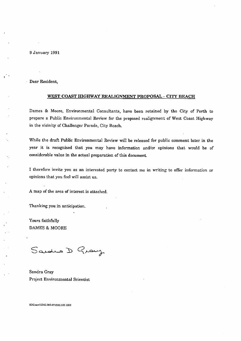
9 January 1991
Dear Resident,
WEST COAST HIGHWAY REALIGNMENT PROPOSAL CITY BEACH
Dames & Moore, Environmental Consultants, have been retained by the City of Perth to
prepare a Public Environmental Review for the proposed realignment of West Coast Highway
in the vicinity of Challenger Parade, City Beach.
While the draft Public Environmental Review will be released for public comment later in the
year it is recognised that you may have information and/or opinions that would be of
considerable value in the actual preparation of this document.
I therefore invite you as an interested party to contact me in writing to offer information or
opinions that you feel will assist us.
A map of the area of interest is attached.
Thanking you in anticipation.
Yours faithfully
DAMES & MOORE
Sandra Gray
Project Environmental Scientist
SDG:sor115345-003-071/DK102.1252

West Coast
Dames & m 0 pinen.. I consu1tañs, have been pinte&y h.Cityof Perth tounderbke en mnmënidpiiblic opinion studies for re lignmentof the West Coast -Highway neaiChalIenér Parade City Beach.
A-draft.Pul,Ik Environmental Review is -to be released for pubiccornment later in - the year. In the meantimernembers of the public who want to offer:suggestions are invited to write to the Project Manager, Sandra
Cray at 26 LyallSouth•Perth, 615L
M~
Es

APPENDIX C
REPORTED ACCIDENT STATISTICS
WEST COAST HIGHWAY (ROCBDALE ROADIHELSTON AVENUE), CITY BEACH
01 JANUARY 1985 TO 15 NOVEMBER 1990
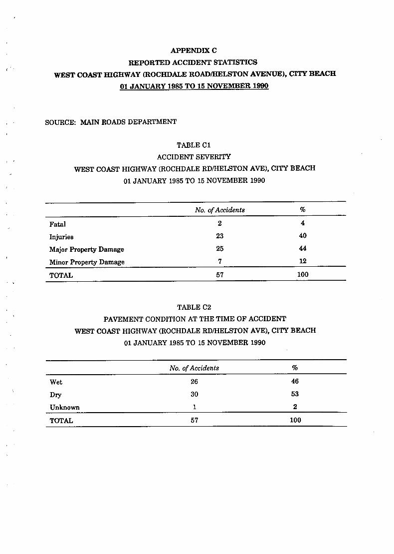
APPENDIX C
REPORTED ACCIDENT STATISTICS
WEST COAST HIGHWAY (ROCHDALE ROADIHELSTON AVENUE), CITY BEACH
01 JANUARY 1985 TO 15 NOVEMBER 1990
SOURCE: MAIN ROADS DEPARTMENT
TABLE Cl
ACCIDENT SEVERITY
WEST COAST HIGHWAY (ROCHDALE RDIHELSTON AVE), CITY BEACH
01 JANUARY 1985 TO 15 NOVEMBER 1990
No. of Accidents %
Fatal 2 4
Injuries 23 40
Major Property Damage 25 44
Minor Property Damage 7 12
TOTAL 57 100
TABLE C2
PAVEMENT CONDITION AT THE TIME OF ACCIDENT
WEST COAST HIGHWAY (ROCHDALE RD/HELSTON AVE), CITY BEACH
01 JANUARY 1985 TO 15 NOVEMBER 1990
No. of Accidents %
Wet 26 46
Dry 30 53
Unknown 1 2
TOTAL 57 100

C - 2
TABLE C3
ROAD ALIGNMENT AT SITE OF ACCIDENT
WEST COAST HIGHWAY (ROCHDALE RD/HELSTON AVE), CITY BEACH
01 JANUARY 1985 TO 15 NOVEMBER 1990
No. of Accidents %
Curve 50 88
Straight 7 12
TOTAL 57 100
TABLE C4
ROAD GRADE AT POINT OF ACCIDENT
WEST COAST HIGHWAY (ROCHDALE RD/HELSTON AVE), CITY BEACH
01 JANUARY 1985 TO 15 NOVEMBER 1990
No.
Level 19 33
Crest of Hill 2 4
Slope 36 63
TOTAL 57 100
TABLEC5
LIGHT CONDITIONS AT TIME OF ACCIDENT
WEST COAST HIGHWAY (ROCHDALE RD/HELSTON AVE), CITY BEACH
01 JANUARY 1985 TO 15 NOVEMBER 1990
No. %
Daylight 28 49
Dusk 1 2
Dark/Street Lights On 25 44
Dark/Street Lights Off 1 2
Unknown 2 4
TOTAL 57 100

C - 3
TABLE C6
ACCIDENTS INVOLVING COLLISION WITH FIXED OBJECT
WEST COAST HIGHWAY (ROCHDALE RD/HELSTON AVE), CITY BEACH
01 JANUARY 1985 TO 15 NOVEMBER 1990
No. %
SEC/PMG Poles 18 36
Traffic Sign Posts 2. 4
Trees 10 .--. 20
TOTAL 30 60
TABLE C7
REPORTED ACCIDENT STATISTICS AT SIX MONTHLY INTERVALS
WEST COAST HIGHWAY (ROCHDALE RD/HELSTON AVE), CITY BEACH
01 JANUARY 1985 TO 15 NOVEMBER 1990
Time Period No of Accidents
January 1985 - June 1985 2
July 1985 - December 1985 2
January 1986 - June 1986 1
July 1986 - December 1986 3 .
January 1987 - June 1987 2
July 1987 - December 1987 6
January 1988 - June 1988 3
July 1988 - December 1988 5
January 1989 - June 1989 10
July 1989 - December 1989 9
January 1990 - June 1990 7
July 1990 - November 1990 - - 6
o Servetus Street extension to West Coast Highway opened on 3 July 1986
0 Minor modificaions to Challenger Parade junction were carried out in the latter part of 1989

Eq:


APPENDIX 1)
COMPARISON OF OPTIONS
To facilitate the comparison process within the three broad categories, the detailed criteria
have been given a score of 0 (no influence) to 5 (very high degree of adverse impact) in terms of
their perceived impact on the public and the environment in relation to the realignment of the
West Coast Highway. This ensures consistent ranking throughout the study. The criteria
were scored by Dames & Moore ecologists, botanists, social scientists, meteorologists,
hydrogeologists, planners, etc., after discussion and debate.
As a further level of assessment, the criteria have also been weighted to reflect their relative
significance. This ranking has been undertaken using a scale of 1-3. Those criteria considered
to be of major importance in the identification of options suitable for the realignment of West
Coast Highway have been assigned a weighting of 3. Those criteria considered to be of
moderate importance were assigned a weighting of 2 while those of minor importance were
assigned a weighting of 1. The final evaluation is in terms of an overall weighted score for
each alternative.
The raw scores indicate the impact of an option in terms of a set of specific criteria. The
weighted score (i.e. the raw score multiplied by the weighting) attempts to quantifr the relative
importance of each criterion with respect to the others. As a consequence of these procedures,
an option which finishes with a low score has the least adverse impact and an option with a
high score has the greater adverse impact.
This method of scoring, while widely used in research of this type, tends to aggregate the
criteria and hence totals may be simplified in some cases. For example, it is considered that
the safety criterion do not necessarily distinguish the small differences in safety levels between
options. This aggregation is also partially due to the fact that whole scores, not fractions, are
used and therefore one rating of 2 may not be totally equivalent to another rating of 2.
Nonetheless, we have endeavoured to ensure that the calculation of final scores has given equal
weighting to environmental, social and safety factors through a process of normalisation. The
normalisation process is undertaken to ensure that those broad categories which have more
criteria than others are not given an unfair weight. For example, the assessment of
environmental constraints involved twelve criteria, and the possible total weighted score was
165 points. In, contrast, the assessment of safety involved only one criterion, and the total
possible weighted score was only 15 points. The normalised score is obtained by dividing the
weighted score assigned for each category by the total possible weighted score for the
assessment category, thus giving each category equal weighting in the overall assessment.

D - 2
As the weighting is a measurement of the level of adverse impact with the lowest level of
adverse impact scoring 0, the most favourable option will be that one with the lowest overall
score and that satisfies all three categories.
The overall assessment is made by comparing the options in terms of three major categories.
These categories and the criteria within each category are briefly discussed below.
ENVIRONMENTAL ASSESSMENT CATEGORY
The following concerns have been identified as criteria for the environmental assessment and
the results are presented in Table Dl.
Hydrological Issues
The potential for surface stormwater runoff to adversely impact on existing drainage systems
and vegetation has been considered. The likelihood of decreasing groundwater quality/quantity
has been examined.
Ecological Sensitivity
A number of criteria are considered, including the number of habitats and plant associations,
the presence of significant flora and fauna and the implications of each option for the System 6
recommendations (Conservation Through Reserves Committee, 1981). The approximate area of
each vegetation type which would be cleared for each option is shown in Table D2.
SOCIAL ASSESSMENT CATEGORY
The following criteria were considered for an assessment of the social issues and results are
presented in Table Dl.
Air quality
This criterion includes consideration of the impact of poor air quality (i.e. exhaust fumes,
brake-lining dust, dust caused by vehicle movement) on residents, users of the project area and
the potential for air emissions to adversely affect plants.

D - 3
Planning Issues
This criterion considered land uses and the relationship of each option to local, state and policy
planning.
Heritage
The potential for sites of Aboriginal or European heritage significance was considered.
Noise
This criterion evaluates the effect on noise levels experienced by local residents and users of
the project area as a result of moving the alignment of West Coast Highway. It is noted that
current noise levels caused by traffic are probably high. No data are available. It should be
noted that background noise levels are also probably high in this area due to the proximity of
the ocean.
Other Social Issues
Several miscellaneous social issues were considered in this category. Amongst these were the
influence of each option on landscape amenity (e.g. visual impact), the impact of each option on
recreational use of the project area, and ease of access for both residents and users of the
project area.
Economic Costs
The capital and maintenance costs of each option were considered and ranked accordingly.
Community Attitudes
Community attitudes to various issues such as safety, environmental concerns and noise and
air pollution were determined through a programme of public consultation. Section 6.0 outlines
the methods used to survey public opinion.
SAFETY CATEGORY
Considering the road history, safety was considered to be sufficiently important to warrant its
own category. As a result, safety issues have been given equal weighting to environmental and
social concerns. Results are presented in Table Dl.

TABLE Dl
MATRIX OF OPTION SCORES WEST COAST HIGHWAY REALIGNMENT
category Criteria Raw Score Weighted Score Normolleed Score
Weight A B C D B F 0 A B C D B F 0 A B C D B F 0
1 1 1 1 1 2 2 2 2 2 2 2 4 4
1 1 1 1 1 2 2 2 2 2 2 2 4 4
2 2 2 2 4 4 4 4 4 4 4 4 8 8 0.02 0.02 0.02 0.02 0.02 0.05 0.06
0 1 2 2 8 6 4 0 3 6 6 9 15 12
0 1 1 3 5 4 4 0 8 3 9 16 12 12
0 1 2 2 3 2 2 0 8 6 6 9 6 6
0 1 8 4 3 4 3 0 2 6 8 6 8 6
0 1 3 4 5 5 5 0 3 9 12 16 16 16
0 1 1 1 1 1 1 0 3 3 3 3 3 3
0 1 1 2 3 3 3 0 3 3 6 9 9 9
0 1 2 8 4 4 4 0 8 6 9 12 12 12
0 1 1 2 3 3 3 0 8 3 6 9 9 9
0 1 2 2 4 4 4 0 8 6 6 12 12 12
0 10 18 26 84 36 33 0 29 61 71 99 101 96 0.00 0.18 0.81 0.43 0.60 0.61 0.58
0.02 0.20 0.33 0.45 0.02 0.66 0.63
ENVIRONMENTAL ASSESSMENT CATEGORY
HYDROLOGICAL ISSUES
Runoff Effects
2
Potential Impact on Groundwater
2
4
ECOLOGICAL SENSITIVITY
Area Cleared
8
Area Alienated
3
Habitat Type. Affected
3
Plant Associations Affected
2
Presence of Significant Flora
8
Probability of Significant Mammals
3
Probability of Significant Bird.
3
Probability of Significant Herpetouna
3
Probability of Significant Invertobrates
3
Implication, for System 6
3
I GROUP SCORE ENVIRONMENTAL
I ASSESSMENT CATEGORY

TABLE Dl (Continued)
Category /Crlteria
SOCIAL ASSESSMENT CATEGORY
PLANNING ISSUES
Aiienatlon of Exieting/Pigure Lend U...
Confide with City of Perth Planning Scheme
Conflict. with Syctem 6 and Other Policle.
A B
Weighted Score Normoji.rd Score
Weight A B C D S F G C D S F C I A B C D S F G
2 2 2 2 3 4 4 4 4 4 4 6 8 8 8
2 0 1 2 3 4 3 3 0 2 4 6 8 6 6
3 0 1 2 3 5 6 6 0 3 6 9 16 16 16
7 2 4 6 9 13 12 12 4 9 14 21 31 29 29 0.02 0.05 0.08 0.12 0.18 0.17 0.17
HERITAGE
Aboriginal Heritage
European Heritage
AIR QUALITY (EXHAUST EMISSIONS AND DUST)
Impact on Resident.
Impact on Recreatlonist.
Potential for Adverse Impact on Plant.
EXCESSIVE NOISE
Impact on Resident.
Impact on Racreatlonletu
2 0 1 1 1 1 1 1 0 2 2 2 2 2 2
1 0 0 0 0 0 0 0 0 0 0 0 0 0 0
3 0 1 1 1 1 1 1 0 2 2 2 2 2 2 0.00 0.01 0.01 0.01 0.01 0.01 0.01
2 4 4 3 2 1 1 2 8 8 6 4 2 2 4
1 1 1 1 1 2 1 1 1 1 1 1 2 1 1
1 0 1 1 2 2 2 2 0 1 1 2 2 2 2
4 5 6 6 6 6 4 5 9 10 8 7 6 5 7 0.05 0.06 0.06 0.04 0.03 0.03 0.04
2 4 2 3 2 1 2 2 8 4 6 4 2 4 4
1 2 2 2 2 2 2 2 2 2 2 2 2 2 2
3 6 4 6 4 3 4 4 10 6 8 6 4 6 6 0.06 0.03 0.06 0.03 0.02 0.03 0.03
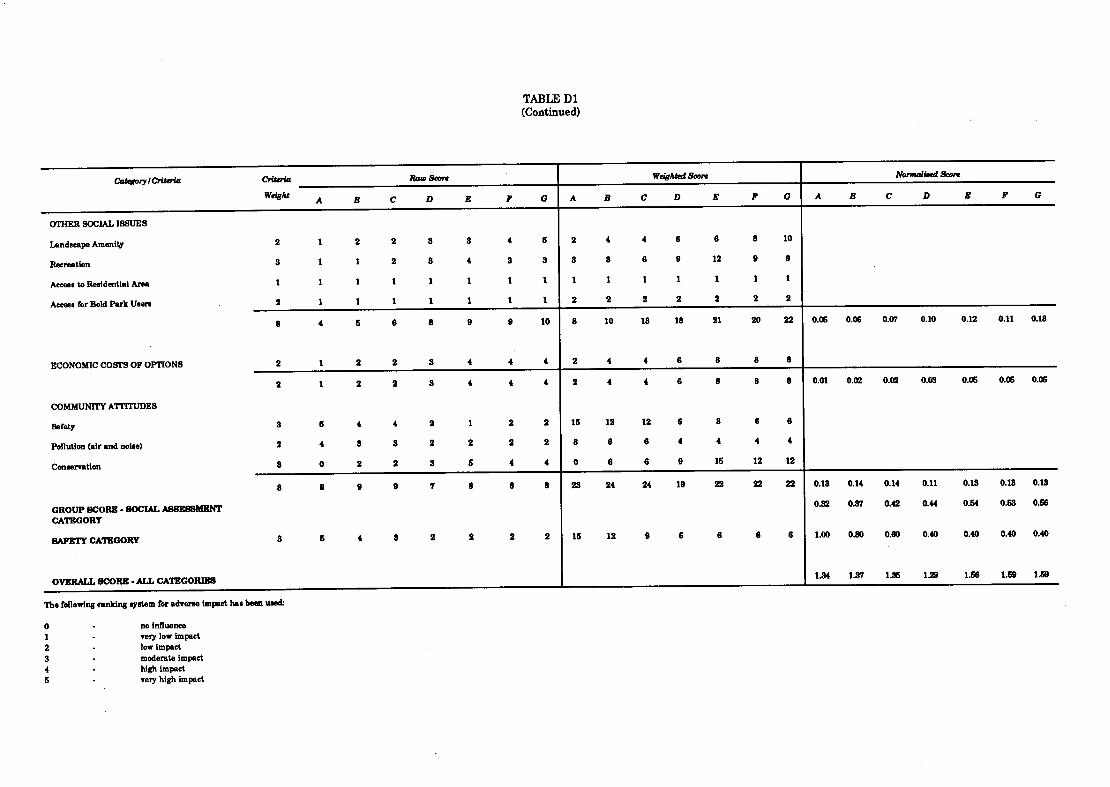
TABLE Dl (Continued)
Categoiy ICriteria Criteria
Weight A B C
Raw Score
I)
OTHER SOCIAL ISSUES
Landscape AmenIty 2 1 2 2 3 3
RecreatIon 3 1 1 2 8 4
Access to Residential Area I 1 1 1 1 1
AcceeuforBoldParkUserl 2 1 1 1 1 1
8 4 5 6 8 9
ECONOMIC COSTS OF OPTIONS 2 1 2 2 S 4
2 1 2 2 3 4
COMMUNITY ATTITUDES
Safety S 6 4 4 2 1
Pollution (air and noise) 2 4 3 3 2 2
ConservatIon 3 0 2 2 3 5
8 9 9 9 7 8
GROUP SCORE SOCIAL AESESSMKNT CATEGORY
SAFETY CATEGORY 3 5 4 3 2 2
OVERALL SCORE . ALL CATEGORIES
The following ranking system for adverse impact has been uaed
0 - no Influence 1 very low impact
2 - low impact
3 . moderate impact
4 - high impact 5 very high impact
Weighted Score Normali.ed Score
F G A B C D B F 0 A B C B B F 0
4 6 2 4 4 6 6 8 10
3 3 8 5 6 9 12 9 9
1 1 1 1 1 1 1 1 1
1 1 2 2 2 2 2 2 2
9 10 8 10 13 18 21 20 22 0.06 0.06 0.07 0.10 0.12 0.11 0.13
4 4 2 4 4 6 8 8 8
4 4 2 4 4 6 8 8 8 0.01 0.02 0.02 0.03 0.06 0.06 0.06
2 2 16 12 12 6 8 6 6
2 2 8 6 6 4 4 4 4
4 4 0 6 6 9 16 12 12
8 8 23 24 24 19 22 22 22 0.13 0.14 0.14 0.11 0.13 0.13 0.18
0.82 0.37 0.42 0.44 0.54 0.53 0166
2 2 16 12 9 6 6 6 6 1.00 0.80 0.80 0.40 0.40 0.40 0.40
1.34 1.37 1.36 129 1.56 1.59 1.59

D - 7
TABLE D2
APPROXIMATE AREA OF VEGETATION TYPE CLEARED FOR EACH REALIGNMENT OPTION
Vegetation Option/Approximate Area Type (ha)
A B C D E F G
1J2B 0 0 0 0 0.125 0 0
2B 0 0 0.25 0.25 0.8 0.45 0
2B/Af 0 0 0 0.625 1.3 0 0
2B/4B 0 0 0.75 0.25 0 1.25 0.5
3A 0 0 0 0 0 0 0
3A/M 0 0.75 0.75 0.25 0 1.2 1.125
3A/M'4C 0 0 0 0 0 0.875 0.625
3A/4C 0 0 0 0 0 1.5 2.125
4B 0 0 0.5 1.125 1.8 1.15 1.0
4B/3A 0 0 0 0 0 0 0
4B/4C 0 0 0 0 0 0 0
4C 0 0.5 0.5 0.875 1.0 1.0 1.0
TOTAL 0 1.25 2.75 3.38 5.03 7.43 6.38
Notes: 1. Area calculated assuming a 50m easement. Due to the mixtures of vegetation it is impossible to give precise figures for individual species that could be destroyed. In order to estimate these areas the vegetation types used are those shown on Figure 7.

-

Enquiries
/
MAIN ROADS DEPARTMENT WATERLOO CRESCENT, EAST PERTH, WESTERN AUSTRALIA. P0 Box 6202 EAST PERTH WA 6004 Phone (09)323 4111 Fax (09) 323 4430 Telex AA 92894_ i
Mr Missikos on 323 4478
Our Ref 72-394-54
Your Ref
The Manager Dames & Moore South Shore Centre 85 The Esplanade SOUTH PERTH WA 6151
ATTENTION: MS GRAY
Dear Madam
PROPOSED RE—ALIGNMENT OF NEST COAST HIGHNAY, CITY BEACH PUBLIC ENVIRONMENTAL REVIEH
I refer to the above proposal and the request for Main Roads to provide comment.
In previous consultations and review Main Roads has recommended a minimum design radius of 400 m.
This minimum radius of 400 m which has been applied to West Coast Highway and in particular the recent connection through the coastal dunes to Marmion Avenue north, provides for an appropriate design at an acceptable level of safety for the Community. It should be noted though that the radius of the preferred design (OPTION E) which provides the shortest and best road alignment is 1 400 m.
Austroads (previously NAASRA) of which Main Roads is a member as the State Road Authority in WA, does not produce standards it provides guidelines to which Engineers develop design standards for particular roads. Minimum radii are only used where necessary and are gradually introduced into the alignment so as to transition the drivers safely into the changed road environment. This is not the situation at present as highlighted by the high level of accidents including Injury and deaths at the S bend.
Taking into account all the factors related with this proposal and in particular the safety standards required by the Community, Main Roads recommends a design standard based on a 400 in minimum radius.
Yours faithfully
D Kilvington ACTING DIRECTOR TRAF IC MANAGEMENT
January 22 1992
TM—i 6011
LIBRARY DEPARTMENT OF ENVIRONMENTAL PROTECTIO:
WESTRALIA SQUARE 141 ST. GEORGES TERRACE, PERTH