title first name last name position organization mailing ... first name last name position...
TRANSCRIPT

Title First Name Last Name Position Organization Mailing Address City State Postal Code Phone No. E-mail AddressMs. Ashley Bunch District 2 Staff City of Phoenix Council 200 W. Washington St., 11th Floor Phoenix AZ 85003-1611 602-262-7445 [email protected]. Brian Schmitt District 2 Staff City of Phoenix Council 200 W. Washington St., 11th Floor Phoenix AZ 85003-1611 602-262-7445 [email protected]. Myesha Harris Floodplain Manager City of Phoenix 200 W. Washington St., 5th Floor Phoenix AZ 85003-1611 602-2626441 [email protected]. Chris Ewell Landscape Architect City of Phoenix Parks and Recreation 200 W. Washington St., 16th Floor Phoenix AZ 85003-1611 602-534-5292 [email protected]. Greg Stanton Mayor City of Phoenix 200 W. Washington St., 11th Floor Phoenix AZ 85003-1611 602-262-7111 [email protected]. Raimundo Dovalina Deputy Street Transportation Director City of Phoenix 200 W. Washington St., 5th Floor Phoenix AZ 85003-1611 602-262-4872 [email protected] Mr. Wylie Bearup Street Transportation Department City of Phoenix 200 W. Washington St., 5th Floor Phoenix AZ 85003-1611 602-262-6136 [email protected]. Neal Young Interim Public Transit Director City of Phoenix 302 N. 1st Ave., Suite 700 Phoenix AZ 85003 602-495-0418 [email protected]. Mike Cynecki Traffic Operations City of Phoenix 200 W. Washington St., 5th Floor Phoenix AZ 85003-1611 602-262-4659 [email protected]. Jenny Grote Traffic Operations City of Phoenix 200 W. Washington St., 5th Floor Phoenix AZ 85003-1611 602-262-4659 [email protected]. Carolyn Bristo Public Works Director (Acting) City of Phoenix 200 W. Washington St., 7th Floor Phoenix AZ 85003-1611 602-495-7274 [email protected]. Joseph B. Klima Commander Black Mountain Precinct, City of Phoenix Police Department 33355 N. Cave Creek Rd. Phoenix AZ 85331 602-495-5002 [email protected]. Bob Khan Fire Chief Phoenix Fire Department 150 S. 12th St. Phoenix AZ 85034-2301 602-262-6297 [email protected]. Joe Yahner Acting Police Chief Phoenix Police Department 620 W. Washington St. Phoenix AZ 85003-2108 602-262-6747 [email protected]. Derek Horn Assitant Director Planning City of Phoenix Planning and Development Department 200 W. Washington St., 3rd Floor Phoenix AZ 85003-1611 602-262-7131 [email protected]. Tricia Gomes Desert View Village Planning Committee Coordinator City of Phoenix Planning and Development Department 200 W. Washington St., 3rd Floor Phoenix AZ 85003-1611 602-262-6949 [email protected]. James P. Lee Superintendent Paradise Valley Unified School District 15002 N. 32nd St. Phoenix AZ 85032 602-449-2000 [email protected]. Jason Reyonlds Principal Pinnacle High School 3535 E. Mayo Blvd. Phoenix AZ 85050 602-449-4000 [email protected]
Title First Name Last Name Position Organization Mailing Address City State Postal Code Phone No. E-mail Address
Ms. Theresa Pinto Project Manager Flood Control District of Maricopa County 2801 W. Durango St. Phoenix AZ 85009 602-506-8127 [email protected]. Doug Williams Planning Branch Manager Flood Control District of Maricopa County 2801 W. Durango St. Phoenix AZ 85009 602-506-8743 [email protected]. Timothy S. Phillips, P.E. Chief Engineer & General Manager Flood Control District of Maricopa County 2801 W. Durango St. Phoenix AZ 85009-6356 602-506-0538 [email protected]. Tim Oliver Acting Planning Division Manager Maricopa County Department of Transportation 2901 W. Durango St. Phoenix AZ 85009-6357 602-506-8600 [email protected]
Mr. Dennis Smith Executive Director Maricopa Association of Governments 302 N. 1st Ave., Suite 300 Phoenix AZ 85003-1500 602-254-6300 [email protected]
Mr. Eric Anderson Transportation Director Maricopa Association of Governments 302 N. 1st Ave., Suite 300 Phoenix AZ 85003-1562 602-254-6300 [email protected]
Mr. Bob Hazlett Senior Engineer Maricopa Association of Governments 302 N. 1st Ave., Suite 300 Phoenix AZ 85003-1562 602-452-5026 [email protected]
Mr. Micah Henry ITS Engineer Maricopa Association of Governments 302 N. 1st Ave., Suite 300 Phoenix AZ 85003-1562 602-254-6300 [email protected]. Stuart Boggs Transit Planning Manager Valley Metro 101 N. 1st Ave., Suite 1100 Phoenix AZ 85003 602-523-6039 [email protected]

Title First Name Last Name Position Organization Mailing Address City State Postal Code Phone No. E-mail AddressMr. Mark Edelman Planning Unit Supervisor Arizona State Land Department 1616 W. Adams St. Phoenix AZ 85007 602-542-6331 [email protected]. Ruben Ojeda Rights of Way Section Manager Arizona State Land Department 1616 W. Adams St. Phoenix AZ 85007 602-542-2648 [email protected]. Susan Russell Land Disposition Project Leader Arizona State Land Department 1616 W. Adams St. Phoenix AZ 85007 602-542-3115 [email protected]. Gordon Taylor Arizona State Land Department 1616 W. Adams St. Phoenix AZ 85007 [email protected]. Tom Fitzgerald Land Administrator Central Arizona Water Conservation District 23636 N. 7th St. Phoenix AZ 85024 623-869-2333 tfitzgerald@cap‐az.comMs. Marilyn Thomas Lands/Records Assistant Central Arizona Water Conservation District 23636 N. 7th St. Phoenix AZ 85024 623-869-2265 mthomas@cap‐az.comMr. Aaron Ashcroft Central Arizona Water Conservation District 623-869-2257 aashcroft@cap‐az.comMr. Randy Randolph Central Arizona Water Conservation District 623-869-2260 rrandolph@cap‐az.comMr. Robert Halliday Director Arizona Department of Public Safety P.O. Box 6638 Phoenix AZ 85005-6638 602-223-2000 [email protected]. Pete Borquez District Commander Arizona Department of Public Safety P.O. Box 6638 Phoenix AZ 85005-6638 602-223-2000 [email protected]. Larry Voyles Director Arizona Game and Fish Department 5000 W. Carefree Hwy. Phoenix AZ 85086-5000 602-942-3000 [email protected]. Laura Canaca Project Evaluation Program Supervisor Arizona Game and Fish Department 5000 W. Carefree Hwy. Phoenix AZ 85086-5000 623-236-7602 [email protected]. Kelly Wolff-Krauter Arizona Game and Fish Department Kwolff‐[email protected]. Chip Young Arizona Game and Fish Department [email protected]. Sandra Fabritz-Whitney Director Arizona Department of Water Resources 3550 N. Central Ave. Phoenix AZ 85012 602-771-8586 [email protected]. Henry Darwin Director Arizona Department of Environmental Quality 1110 W. Washington St. Phoenix AZ 85007 602-771-2203 [email protected]. Shannon Ford Environmental Planner Arizona Department of Transportation 1611 W. Jackson, MD EM02 Phoenix AZ 85007 602-712-6819 [email protected]. Ron McCally Project Manager Arizona Department of Transportation 1611 W. Jackson, MD EM01 Phoenix AZ 85007 602-712-7646 [email protected]

Title First Name Last Name Position Organization Mailing Address City State Postal Code Phone No. E-mail AddressMs. Sandra Eto Environmental Protection Specialist Bureau of Reclamation 6150 W. Thunderbird Rd. Glendale AZ 85306 623-773-6254 [email protected]. Stephen Johnson Recreation Manager Bureau of Reclamation 6150 W. Thunderbird Rd. Glendale AZ 85306 623-773-6485 [email protected]. Ken Davis Senior Engineering Manager Federal Highway Administration 4000 N. Central Ave., Suite 1500 Phoenix AZ 85009 602-382-8970 [email protected]. Tom Deitering Area Engineer Federal Highway Administration 4000 N. Central Ave., Suite 1500 Phoenix AZ 85009 602-382-8971 [email protected]. Rebecca Swiecki Environmental Program Manager Federal Highway Administration 4000 N. Central Ave., Suite 1500 Phoenix AZ 85009 602-382-8998 [email protected]. Sallie McGuire Section Chief Arizona Section, Regulatory Branch, US Army Corps of Engineers 3636 N. Central Ave., Suite 900 Phoenix AZ 85012-1939 602.640.5385 x 222 [email protected]. Kathleen Tucker ADOT Liason Arizona Section, Regulatory Branch, US Army Corps of Engineers 3636 N. Central Ave., Suite 900 Phoenix AZ 85012-1939 602-230-6956 [email protected]. Steve Spangle Field Supervisor USFWS Arizona Ecological Services Field Office 2321 W. Royal Palm Rd., Suite 103 Phoenix AZ 85021-4915 602-242-0210 [email protected]. Debra Bills Assistant Field Supervisor for Central Arizona USFWS Arizona Ecological Services Field Office 2321 W. Royal Palm Rd., Suite 103 Phoenix AZ 85021-4915 602-242-0210 [email protected]
4561 E. McDowell Road Phoenix, AZ 85008 602.454.0402 602.454.0403 (fax)
January 17, 2012
Re: Black Mountain Boulevard, SR 51/101 to Cave Creek Road
TRACS No. SS979 03D
Project No. PHX-0(266)A
Dear Recipient:
The City of Phoenix, in conjunction with the Arizona Department of Transportation (ADOT) and the Federal Highway
Administration (FHWA), are initiating engineering and environmental studies for the proposed Black Mountain
Boulevard project. This north-south arterial street would connect State Route 51 near its current terminus at State Route
101 to Cave Creek Road (enclosed Figures 1 and 2). The study corridor is located within the City of Phoenix and traverses
lands managed by ADOT, the Bureau of Reclamation (Reach 11 of the Central Arizona Project Canal), State Trust lands
managed by the Arizona State Land Department, and private lands. The City of Phoenix Transportation Plan identifies the
planned street to have direct ramp connections to north and southbound State Route 51, and to ultimately have three lanes
in each direction, a raised median, and sidewalks and bicycles lanes along the corridor.
This letter serves as your agency’s invitation to review the proposed project study area in the context of a new arterial
street corridor as outlined above. If you or others in your organization have any specific concerns, comments, or
recommendations pertaining to this proposed project or study area, please let us know. This may include, for example,
information on any social, economic, or environmental considerations, or general plans, capital improvement projects, or
development projects that would potentially be affected.
The City of Phoenix and ADOT will be conducting an agency scoping meeting on Tuesday, January 24, 2012, beginning
at 1:00 p.m. The meeting will be held in AZTEC Engineering’s Offices located at 4561 East McDowell Road, Phoenix,
Arizona. If you or someone from your agency cannot attend and would still like to have a continued involvement, please
expressly state such, along with a description of your specific concerns, in your response letter.
AZTEC Engineering is assisting the City of Phoenix and ADOT with the engineering and environmental studies. Please
address your comments or concerns to Mr. David Webb via mail at AZTEC, 4561 East McDowell Road, Phoenix,
Arizona 85008, via e-mail at [email protected], or via fax at 602.454.0403. We ask that your comments be submitted by
February 24, 2012.
Thank you for your time and assistance.
Sincerely,
David Webb
Environmental Planner
AZTEC Engineering
Enclosures: Figure 1 – Maricopa County Location Map
Figure 2 – Study Vicinity Map
c: Shane Silsby, City of Phoenix
Shannon Ford, ADOT Environmental Planning Group
Ron McCally, ADOT Valley Project Management
Tom Deitering, FHWA
Rebecca Swiecki, FHWA
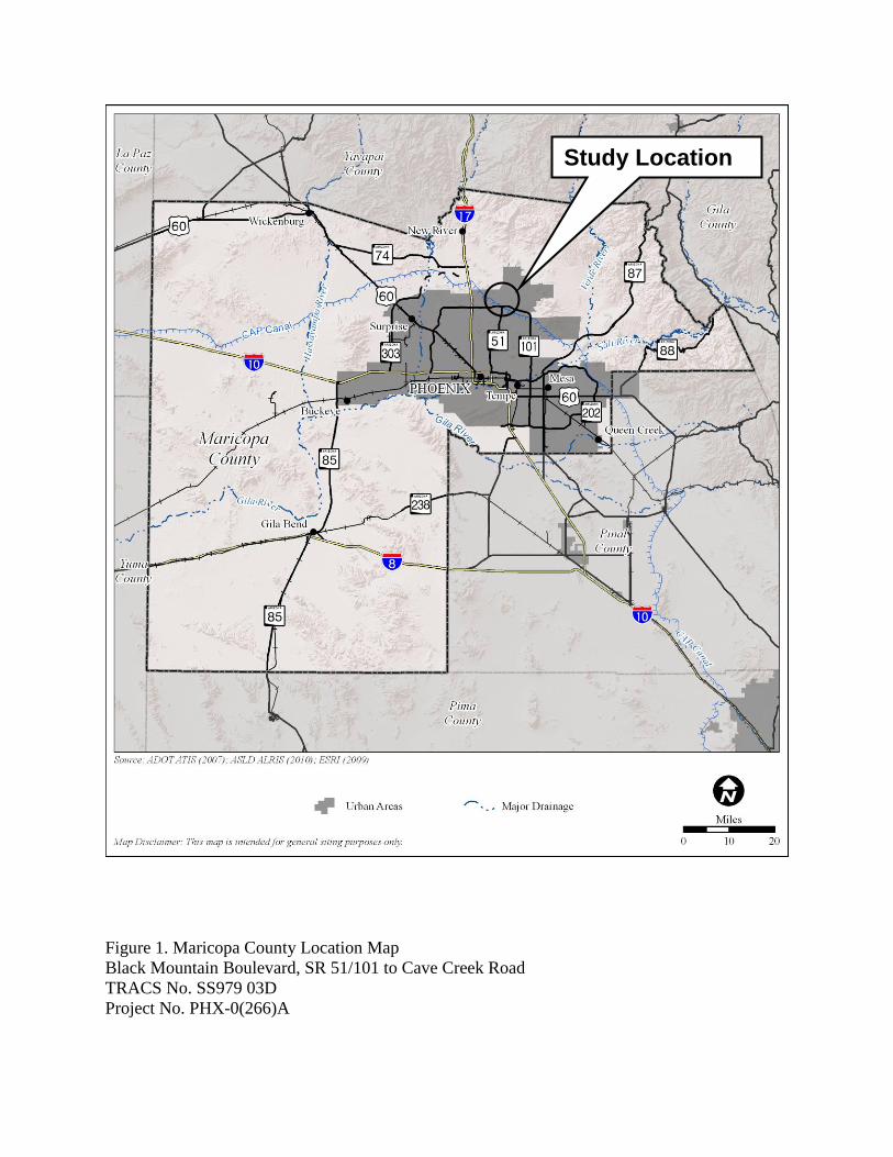
Figure 1. Maricopa County Location Map
Black Mountain Boulevard, SR 51/101 to Cave Creek Road
TRACS No. SS979 03D
Project No. PHX-0(266)A
Study Location

Figure 2. Study Vicinity Map
Black Mountain Boulevard, SR 51/101 to Cave Creek Road
TRACS No. SS979 03D
Project No. PHX-0(266)A

Meeting Date: 01/24/2012 Meeting Time: 1:00 p.m.
Location: AZTEC Engineering 4561 E. McDowell Road Phoenix, 85008
Project: BMB - SR 51/101 TI to Cave Creek Road
Subject: Agency input Project No: SS979 03D
Attendees: See attached sign-in sheet Date Published: 02/03/2012
The Meeting Agenda is included with these notes. Introductions/Sign-in-Sheet Scott McKenzie, AZTEC Engineering, explained the purpose of the meeting, which is to introduce and describe the study for Black Mountain Boulevard (BMB) and gather input from the invited agencies. The project team, including members of the sponsoring agencies (City of Phoenix, Federal Highway Administration [FHWA], and Arizona Department of Transportation [ADOT]) was introduced. The remaining attendees did self introductions. See the attached sign-in sheet. Shane Silsby, City of Phoenix Street Transportation Department, explained the relationships between the project sponsors. BMB, for the segment up to Deer Valley Road, is funded by the Maricopa Association of Governments (MAG) arterial streets program through the 2004 voter-approved county sales tax. BMB originates at is south end from State Route 51, which is an ADOT-managed facility. Because the MAG funding creates a federal nexus, FHWA will provide oversight of the BMB study and which requires compliance with the National Environmental Policy Act (NEPA). Through an Intergovernmental Agreement between the City and ADOT, ADOT will administer the design and construction. Study Overview Scott McKenzie presented a slideshow and described the original concept of BMB beginning with its tie-in to the planning of Desert Ridge in 1990. In 1994, BMB appeared in the City of Phoenix Arterial Street Classification Map and was incorporated into the General Plan. As part of the construction project for the SR51/SR101 System Interchange and funded by the City, ramp stubs for the future connections of BMB were constructed at the SR51/SR101L Interchange (TI). The current study limits are from the SR51/SR101L TI to Cave Creek Road at the approximate location where future Sonoran Boulevard would connect. The study limits also extend along the alignment of SR 101 to the east and west of the SR51/SR101L TI. This would allow the team to evaluate the engineering feasibility of ingress/egress to SR101 from BMB based on comments received from the public to date. Although the study limits are shown through areas that currently developed as residential, it is not the intent of the study to propose alignments through already developed areas. These study limits are shown to indicate that potential impacts in the developed areas will be part of the study. The breakdown of funding for the proposed BMB project was provided; the MAG Arterial Life Cycle Program funds are approximately 70% of the costs with the City of Phoenix contributing the remaining 30%. The implementation of the proposed project would have design occurring in fiscal years (FY) 2011 and 2012, right-of-way acquisition occurring in FY 2012, and construction in FY 2013/2014. The progress-to-date with public involvement and meetings with the stakeholder group was described. The City of Phoenix has already met with the individual homeowner associations, village planning committee, and convened a stakeholder group. Project websites have been available and www.blackmountainblvd.com is being been used to gather comments from the public. The BMB Study will follow the federal process and the requirements of NEPA. Following the agency scoping meeting, two public scoping meetings have been scheduled for January 25 and 26 at locations within or adjacent to the study area.

Agency Scoping Meeting January 24, 2012
Page | 2
The deliverables that will be prepared by the study team will include a Preliminary Engineering Scoping Report (PESR) and an Environmental Assessment (EA). The PESR and EA will cover the entire study limits from the SR51/SR101L TI to Cave Creek Road, and stage II design documents will be prepared for the BMB segment from SR51/SR101L TI to Deer Valley Road. The drafts of the PESR and EA will be prepared by summer 2012. The final PESR, stage II documents, and final EA will be completed in fall 2012. Questions and Answers, and Agency Comments The attendees were asked if they had any questions or comments that could be addressed at the meeting. Each attendee was asked for input. Comment: Lieutenant Dan Olson of the Phoenix Police did not have any questions but mentioned that the neighborhoods in the study area have community action officers that work with the police department. Lt. Olson offered to put the project team in contact with these individuals if necessary. Comment: Shane Silsby of the City of Phoenix Street Transportation Department described the landownership of the study area that includes State Trust Land managed by the Arizona State Land Department (ASLD), the Veteran’s Cemetery that is managed by the Veterans Administration, and Reach 11 of the Central Arizona Project Canal that is managed by the Bureau of Reclamation. Reach 11 has specific requirements in regards to flooding that the project team is aware of. The project team is also aware of the communities’ concerns with safety for the students of Pinnacle High School. Question: Syd Anderson of the City of Phoenix Street Maintenance Department asked if the delivery method for the construction contract for BMB had been determined. Answer: It will likely be a conventional design-bid-build contract. Question: Mr. Anderson also asked if BMB would be constructed at-grade. Answer: It will be elevated as it departs from the SR51/SR101L TI but will come down to grade for the remainder of the alignment. Comment: Stuart Boggs of Valley Metro requested that BMB be designed to account for transit, especially to accommodate busses and their turning movements. He also requested rotaries at major intersections so busses could turn around without traveling through adjacent neighborhoods. Response: Transit will be a consideration of the study and any subsequent design efforts. Comment: Mark Melnychenko of the City of Phoenix Public Transit Department mentioned that there are two park-and-ride facilities and rapid transit lines planned for the study area. The vacant land west of the intersection of Tatum and Deer Valley is designated for development as a park-and-ride. Question: Mr. Melnychenko also asked if there would be high-occupancy vehicle (HOV) lanes connecting SR 51 to BMB. Answer: No, the current plans are for all lanes entering/leaving BMB to be general-purpose lanes. Question: Micah Henry of MAG asked if the entire corridor including areas north of Deer Valley Road was being considered in the study. Answer: Yes. Question: Mr. Henry also asked if right-of-way procurement had become involved yet. Answer: Not yet. Questions: Mr. Henry inquired as to how detailed the design would be for the segment of alternatives north of Deer Valley Road. Answer: The designs will be done to about 10-15% stage, typical to a study level.
Agency Scoping Meeting January 24, 2012
Page | 3
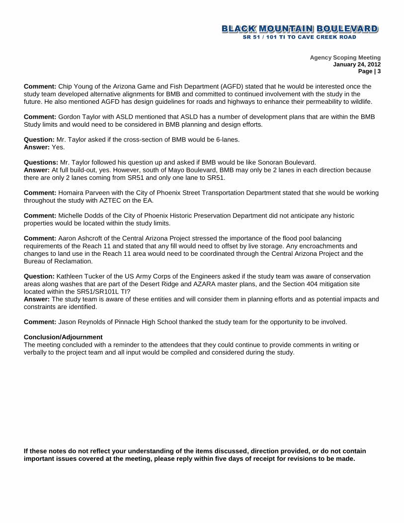
Comment: Chip Young of the Arizona Game and Fish Department (AGFD) stated that he would be interested once the study team developed alternative alignments for BMB and committed to continued involvement with the study in the future. He also mentioned AGFD has design guidelines for roads and highways to enhance their permeability to wildlife. Comment: Gordon Taylor with ASLD mentioned that ASLD has a number of development plans that are within the BMB Study limits and would need to be considered in BMB planning and design efforts. Question: Mr. Taylor asked if the cross-section of BMB would be 6-lanes. Answer: Yes. Questions: Mr. Taylor followed his question up and asked if BMB would be like Sonoran Boulevard. Answer: At full build-out, yes. However, south of Mayo Boulevard, BMB may only be 2 lanes in each direction because there are only 2 lanes coming from SR51 and only one lane to SR51. Comment: Homaira Parveen with the City of Phoenix Street Transportation Department stated that she would be working throughout the study with AZTEC on the EA. Comment: Michelle Dodds of the City of Phoenix Historic Preservation Department did not anticipate any historic properties would be located within the study limits. Comment: Aaron Ashcroft of the Central Arizona Project stressed the importance of the flood pool balancing requirements of the Reach 11 and stated that any fill would need to offset by live storage. Any encroachments and changes to land use in the Reach 11 area would need to be coordinated through the Central Arizona Project and the Bureau of Reclamation. Question: Kathleen Tucker of the US Army Corps of the Engineers asked if the study team was aware of conservation areas along washes that are part of the Desert Ridge and AZARA master plans, and the Section 404 mitigation site located within the SR51/SR101L TI? Answer: The study team is aware of these entities and will consider them in planning efforts and as potential impacts and constraints are identified. Comment: Jason Reynolds of Pinnacle High School thanked the study team for the opportunity to be involved. Conclusion/Adjournment The meeting concluded with a reminder to the attendees that they could continue to provide comments in writing or verbally to the project team and all input would be compiled and considered during the study. If these notes do not reflect your understanding of the items discussed, direction provided, or do not contain important issues covered at the meeting, please reply within five days of receipt for revisions to be made.
AGENDA – Agency Scoping Meeting
Project: Black Mountain Boulevard, SR 51/101L Interchange to Cave Creek Road
Project No. PHX-0(266)A
Date & Time: Tuesday, January 24, 2012, 1:00 p.m.
Location: AZTEC Engineering Training Room, 4561 E. McDowell Rd., Phoenix 85008
1. Opening Remarks (Shane Silsby/Leticia Vargas-City of Phoenix)
2. Introductions
3. Study Presentation (Scott McKenzie-AZTEC Engineering)
History
Study Area
Goals
Funding
Progress to Date
Study Process – Engineering & Environmental
Public/Stakeholder Involvement
Project Website & Hotline
4. Agency Comments – Questions and Answers
5. Wrap up and Adjourn


1
David Webb
From: Wendy S. LeStarge [[email protected]]Sent: Thursday, February 23, 2012 11:30 AMTo: David WebbCc: Linda C. TauntSubject: Black Mountain Boulevard, SR 51/101 to Cave Creek Road
This message is sent on behalf of Linda Taunt, Deputy Division Director of the Arizona Department of Environmental Quality, Water Quality Division (ADEQ): We received the request to review the proposed study corridor for the Black Mountain Boulevard, SR 51/101 to Cave Creek Road project for purposes of engineering and environmental studies. Based on the information provided, this project would likely require permit coverage under the Arizona Pollutant Discharge Elimination System program, specifically the Construction General Permit. The project could require a Clean Water Act section 404 permit. There are no surface waters identified as “impaired waters” according to Arizona’s 2006/2008 303(d) Impaired Waters list or the Draft 2010 Status of Water Quality in Arizona 305(b) Assessment and 303(d) Listing Report. There are no surface waters identified as an Outstanding Arizona Water according to Arizona Administrative Code, R18-11-112. We look forward to the opportunity for a more thorough review at the time a draft environmental assessment or draft environmental impact statement is completed. Wendy LeStarge Environmental Rules Specialist Arizona Department of Environmental Quality Water Quality Division (602) 771-4836
NOTICE: This e-mail (and any attachments) may contain PRIVILEGED OR CONFIDENTIAL information and is intended only for the use of the specific individual(s) to whom it is addressed. It may contain information that is privileged and confidential under state and federal law. This information may be used or disclosed only in accordance with law, and you may be subject to penalties under law for improper use or further disclosure of the information in this e-mail and its attachments. If you have received this e-mail in error, please immediately notify the person named above by reply e-mail, and then delete the original e-mail. Thank you.
Click here to report this email as spam.

1
David Webb
From: Ronald McCally [[email protected]]Sent: Wednesday, February 08, 2012 1:42 PMTo: David WebbCc: Scott McKenzie; Jim Romero; Steve BeasleySubject: FW: BMB Agency Scoping letter/ADOT commentsAttachments: BMBAgencyScoping letter.pdf
David, Here are the official ADOT comments in response to the attached Agency scoping letter. Thanks, Ron (7646)
From: Steve Beasley Sent: Wednesday, February 08, 2012 1:17 PM To: Ronald McCally Subject: RE: BMB Agency Scoping letter/ADOT comments? Ron, Please review and forward to David Webb. Direct ramp connections to Loop 101 from Black Mountain Boulevard have not been included in any programming, including the RTP. Also, direct ramp connections would require extensive reconstruction of Loop 101, and additional impacts to the Reach 11 Recreation site, the CAP canal, and the flood retarding structure and low-flow channel. The SR51/101 TI was constructed to include the ramps to Black Mountain Boulevard. The preliminary design of ramp connections to Black Mountain Boulevard minimizes the impacts to Reach 11 and the recreational area, the CAP Canal, the flood retarding structure, and the low-flow channel. The connections were developed based on the City’s proposed location of Black Mountain Boulevard. Any alternative that affects either Loop 101 or the system interchange at SR51 needs to be thoroughly evaluated for impacts to operation and maintenance of the interchange and Loop 101 itself, and would need to be discussed in depth with Phoenix Maintenance District. Any alternative that increases ADOT’s maintenance responsibilities in the area and changes control of access limits in the area will need to be discussed with the PMD. Alternatives need to be evaluated for constructability in order to minimize the inconvenience/construction impacts to the traveling public. Thanks,
Steve Steve Beasley Valley Project Management


1
David Webb
To: Mike ShirleySubject: RE: Follow-up from CAWCD/Reclamation/AZtec/ADOT mtg on 1/23 re. Black Mountain
Boulevard Loop 101 at the SR 51 interchange
From: Eto, Sandra [mailto:[email protected]] Sent: Tuesday, January 24, 2012 12:10 PM To: Jim Romero; [email protected]; Marv Small; Scott McKenzie; Mike Shirley; Thomas Fitzgerald; Castaneda, Peter O; Bott, Steven W Cc: Johnson, Stephen C; [email protected]; [email protected]; [email protected]; [email protected] Subject: Follow-up from CAWCD/Reclamation/AZtec/ADOT mtg on 1/23 re. Black Mountain Boulevard Loop 101 at the SR 51 interchange All— I spoke to Pete Castaneda after our meeting yesterday morning. He agrees with Tom Fitzgerald that an alignment along the western side of the school would constitute a lateral encroachment for the portion within Reach 11, which we, as a policy, do not allow. Beyond that, we would look at any special or extenuating circumstances that would give us a reason to consider otherwise. BTW, Jim/Mike‐I’m swamped today and will very likely not be coming to today’s agency scoping meeting. Please let me know if I missed anything important. Thanks. Sandra Eto Environmental Resource Management Division Phoenix Area Office, Reclamation 6150 W. Thunderbird Road Glendale, AZ 85306-4001 623-773-6254 (office) 623-773-6486 (fax) [email protected]
Click here to report this email as spam.

1
David Webb
From: [email protected]: Wednesday, February 01, 2012 5:00 PMTo: David WebbSubject: RE: Agency Scoping Meeting: Black Mountain Boulevard, SR 51/101 to Cave Creek RoadAttachments: Desert_Villiage_Planning_Committee_Q&A.pdf
David, Thank you for sending me the meeting notes from the Desert View VPC meeting on December 6, 2011 and for adding me to the distribution list. I look forward to working with you in the future. Thank you, Tricia Gomes North Gateway, Rio Vista and Laveen Village Planner City of Phoenix Planning and Development Department 200 West Washington Street, 3rd Floor Phoenix, AZ 85003-1611 [email protected] Office: 602-262-6949 Fax: 602-732-2588
"David Webb" <[email protected]>
02/01/2012 04:37 PM
To Tricia Gomes/PLN/PHX@PHXENT
cc Leticia Vargas/STR/PHX@PHXENT, "Scott McKenzie" <[email protected]>, "Mike Shirley" <[email protected]>, "Jim Romero" <[email protected]>, "Marsha Miller" <[email protected]>, "AZE1134 - BlackMtnBlvd_SR51_101TI_to_CaveCreekRd" <[email protected]>
Subject RE: Agency Scoping Meeting: Black Mountain Boulevard, SR 51/101 to Cave Creek Road
Hi Tricia, I have updated my list of agency personnel contacts to indicate that you have taken over from Jacob Zonn. I have attached the meeting notes from the Desert View Village Planning Committee Meeting held on December 6, 2011. Members of the Black Mountain Boulevard Study Team attended this meeting and after a brief presentation, engaged in a Q&A session with the committee members and attendees. Please contact me if you have any other comments or questions, and we will keep you on the distribution list for future correspondence. Respectfully, David Webb | AZTEC | 4561 E. McDowell Road | Phoenix, AZ 85008 O: 602.454.0402 | D: 602.458.9289 | F: 602.454.0403 | C: 602.391.5443 | mailto:[email protected] From: [email protected] [mailto:[email protected]] Sent: Tuesday, January 24, 2012 9:08 AM To: David Webb Subject: Fw: Agency Scoping Meeting: Black Mountain Boulevard, SR 51/101 to Cave Creek Road

2
David, I will not be able to attend today's meeting regarding Black Mountain Boulevard due to a scheduling conflict. However, I would like to continue to be informed of what is going on and included in future meetings. I will be taking over for Jacob Zonn as the Desert View Village Planner in February. Please let me know if you have any questions. Thank you, Tricia Gomes North Gateway, Rio Vista and Laveen Village Planner City of Phoenix Planning and Development Department 200 West Washington Street, 3rd Floor Phoenix, AZ 85003-1611 [email protected] Office: 602-262-6949 Fax: 602-732-2588 ----- Forwarded by Tricia Gomes/PLN/PHX on 01/24/2012 09:03 AM ----- Calendar Entry Meeting
Subject
Agency Scoping Meeting: Black Mountain Boulevard, SR 51/101 to Cave Creek Road
When
Starts Tue 01/24/2012 01:00 PM 2 hoursEnds Tue 01/24/2012 03:00 PM
Chair [email protected]
Where
Location
AZTEC Engineering, Training Room, 4561 E. McDowell Rd., Phoenix, 85008
ReservedNo rooms or resources have been reserved

1
David Webb
From: David WebbSent: Thursday, February 02, 2012 3:09 PMTo: '[email protected]'Cc: [email protected]; Scott McKenzie; Mike Shirley; Jim Romero; 'Marsha Miller';
AZE1134 - BlackMtnBlvd_SR51_101TI_to_CaveCreekRdSubject: Agency Scoping Meeting: Black Mountain Boulevard, SR 51/101 to Cave Creek Road
District Commander Borquez: Thank you for responding by telephone to our request to have continued involvement in the Black Mountain Boulevard Engineering and Environmental Study. I have updated my records to indicate that you are the official point of contact for the Department of Public Safety and we will include you on future correspondence and notices regarding this study. If you have any comments or questions, please contact me using the information provided below. Respectfully, David Webb | AZTEC | 4561 E. McDowell Road | Phoenix, AZ 85008 O: 602.454.0402 | D: 602.458.9289 | F: 602.454.0403 | C: 602.391.5443 | mailto:[email protected]


Black Mountain Blvd, SR 51/101 TI to Cave Creek Road 1
Desert View Village Planning Committee
Meeting Notes
Meeting Date: 12/06/2011 Meeting Time: 6:30 PM Location: Paradise Valley Community Center,
Multi‐purpose Room, 17402 N. 40th St., Phoenix, AZ
Subject: Desert View Village Planning Committee Meeting – Q&A
Attendees: Jacob Zonn, DVV Planning Representative
Members of the Committee D2 Councilperson Project Manager Deputy Street Transportation Director AZTEC KDA Creative
Comments/Questions from the Village Planning Committee & Answers/Responses
Q: In the alternative depicting 90 degree turns in the SR 51 to Black Mountain Boulevard (BMB) ramps, what is the distance from the beginning of the NB SR 51 to NB BMB ramp to the 90‐degree turn?
A: Approximately 0.5 mile is shown in the preliminary concept. Q: As follow‐up to the first question, concern was expressed that traffic queues would form and back
traffic up onto the ramps that carry traffic from NB SR 51 to EB and WB SR 101. A: This alternative will be studied to determine what distance is needed to prevent backups that impact the
other ramps at the traffic interchange (TI). Stubs have already been constructed (as part of the original TI construction) for the BMB ramps. The BMB ramps are intended to be two‐lanes for both NB and SB traffic. Clarification was provided to the Committee: the 90‐degree turn alternatives are designed to slow NB traffic before it reaches Pinnacle HS and to reduce the impacts to the Reach 11 Recreation Area and the flood capacity of the area north of the Central Arizona Project (CAP) Canal.
Q: Is the area depicted as green lines on one of the slideshow exhibits the Reach 11 area? A: Yes; the Reach 11 Recreation area is shown on the exhibit (that was displayed at the Committee meeting)
and would be impacted by alternative alignments of BMB that would be constructed west of Pinnacle HS. The Reach 11 Recreation area also provides vital floodwater capacity and maintaining this capacity is a requirement of the project, regardless of which alternative is constructed.
Q: Concern was raised that the new ramps associated with the SR 51 to BMB transition would not be a compatible land use with the Reach 11 Recreation area.
A: Although a land exchange would ordinarily be a possibility to develop a transportation facility in this area and relocate the impacted recreational facilities, this would not be an option given the underlying ownership is the Bureau of Reclamation and not the State.
Q: Is there a cost issue with the BMB alignment being constructed to the west of Pinnacle HS? A: This will be analyzed in further detail. It is apparent that the cost would more than other alternatives
because the additional land acquisition and increased roadway length.

Black Mountain Blvd, SR 51/101 TI to Cave Creek Road 2
Q: If the alignment west of the Pinnacle HS is constructed, the alignment would need to curve back to the east in order to avoid the National Cemetery of Arizona (the Cemetery).
A: This issue has been noted and avoidance of the Cemetery will be a requirement of all alternatives.
Q: In a theoretical scenario where there are no existing development constraints, what would the ideal SR 51 to BMB access be? Would it include access to Loop 101 at this location?
A: One of the two alternatives depicting 90‐degree turns in the SR 51 to BMB ramps may possibly be adapted to provide ramps connecting to Loop 101, but there is no funding to construct ramp connects to Loop 101.
Q: Routing BMB to the west of Pinnacle HS would add traffic from the HS to Deer Valley Road (DVR) and increase congestion. The alternatives with the BMB alignment to the east of the HS would allow traffic from the HS to directly access neighborhoods south of SR 101 without needing to take a circuitous route that would include DVR.
A: Correct
Q: Could you describe how the BMB project would result in cooperation with Pinnacle HS to help address their traffic circulation and parking problems?
A: A potential solution would involve the construction of additional parking facilities on the west side of the HS in conjunction with a land exchange that could occur for a west alignment of BMB. This would reduce the number of students parking in the neighborhood (Fireside at Desert Ridge) east of the HS. If the BMB alignment is constructed east of the HS, pedestrian improvements could be constructed to help the safe movement of pedestrians crossing BMB.
Q: A representative of Pinnacle HS agreed that SR 51 to BMB ramp concepts involving the 90‐degree turns would be preferred by the HS to reduce speeds as NB traffic approaches the HS. He also stated the HS wants another point of access to the HS from DVR to help with their traffic circulation.
A: Request was noted. There has also been a request to study the feasibility of constructing a grade‐separated pedestrian facility (either a pedestrian bridge or a pedestrian tunnel) to address concerns regarding pedestrians crossing BMB. It was also noted that a connection to SR 51 would help congestion at the HS by allowing student traffic to access SR 51 directly without the need to travel on a circuitous route that adds to traffic on other arterials such as DVR, Cave Creek Road, and Tatum Boulevard.
Comment: A representative of the Wildcat Ridge Homeowner’s Association (HOA) made several comments in opposition to the project and stated that similar to the Fireside at Desert Ridge community, his constituents are opposed to the BMB concept. Although he is unaware of the timeframes in which BMB would be constructed, he opined the funds for this project may be better‐spent elsewhere on the Regional Freeway System and the BMB issue could be revisited in another twenty years. A concern he expressed with the current BMB concept alignment east of the HS is the proximity of the ramps to homes and potential noise impacts. A problem not being addressed is the lack of parking at the HS and the students using adjacent neighborhoods to park. The Wildcat Ridge HOA supports the construction of additional parking for the HS to the west of the HS. An important reason for not constructing BMB is the slowed pace of residential development. This project may have been necessary for the growth rates of the recent past, but the current conditions and projected growth rates do not warrant it. Alternate solutions to constructing BMB could include improvements to the arterial street network; for example, improving Rose Garden to Mayo Boulevard or other arterial expansions. These comments and suggestions were noted.

Black Mountain Blvd, SR 51/101 TI to Cave Creek Road 3
Comment: There is a need for BMB now evidently because the traffic congestion on Cave Creek Road, Tatum Boulevard, and Scottsdale Road. However, safety for the HS and the students should remain a priority. The alternative that best accomplishes this and could provide for future SR 101 access at this location is the concept with the 90‐degree turns. Expanding the parking at the school is also important. The street system and freeway traffic interchanges generally follow a mile‐square grid. An exception is between Cave Creek and Tatum. BMB has been part of the planning that allowed the housing to be approved for this area.
Comment: Without constructing access ramps to Loop 101 at the location of the SR 51/BMB ramps, it will
be evident to the public that poor planning occurred. Evaluating access to the Loop 101 will be discussed with Arizona Department of Transportation, the City and the project team.
Q: What is the timeframe for the study to be completed for the entire segment of BMB from SR 51 to Cave Creek Road?
A: This study will be completed next year. The construction of BMB between SR 51 and Mayo Boulevard will take 18 to 24 months to complete. Construction of BMB between Mayo and Cave Creek Road will be driven by development and the timeframes for its construction are not known. There is an effort to acquire the land between the National Cemetery and the adjacent horse property. Acquiring this right‐of‐way is important to establish the alignment so BMB can be constructed north to Pinnacle Peak Road, as members of the public have been suggesting.
Q: In reference to the above response, a Committee member agreed that constructing BMB to Pinnacle
Peak would be good. There is no projected timeframe of when BMB will be constructed to Cave Creek Road?
A: Correct
Q: When will Black Mountain Parkway (BMP) be completed between Cave Creek Road and Carefree Highway (located outside the study area for the current project)?
A: This will happen eventually, but it would be developer‐funded and it is not currently in the five‐year program.
Q: Will BMP be constructed between Cave Creek Road and Dove Valley Road (located outside the study area for the current project)?
A: Yes, but this segment is also developer‐funded and timeframes for its construction are not known.
Comment: Pinnacle Peak HS ingress/egress from BMB will be limited when BMB is connected to SR 51 and traffic volumes increase. This project would also attract traffic from Cave Creek Road and SR 101. Noted

SR 51/101 TI to Cave Creek Road, Black Mountain Blvd 1
4561 E. McDowell Road Phoenix, AZ 85008 602.454.0402 602.454.0403 (fax)
Meeting Notes
Meeting Date: 1/23/2011 Meeting Time: 8:00 AM PM to 9:30 AM Location: BOR Office Project: BMB - SR 51/101 TI to Cave Creek Road Subject: Reach 11 Guidelines Project No: SS979 03D
Attendees: See attached sign-in sheet Date Published:
02/14/12 Revised (Revisions in bold italics) 1/30/2012
1. Introductions
The meeting began with brief introductions by team members from ADOT, the Bureau of Reclamation (BOR), the Central Arizona Project (CAP), and AZTEC. The meeting sign-in list is attached to these notes.
2. Project Background and Description/Open Discussion
AZTEC provided a brief overview of the study area identifying the logical termini of the study, the SR 51/101 TI, Cave Creek Road, and a brief description of the land ownership. AZTEC also presented a graphic depicting the project area. The study area consists of private, state (ADOT and ASLD), federal (National Cemetery and Reclamation for Reach 11 and CAP Canal), and FCDM (Cave Buttes Dam).
AZTEC indicated they have a set of “Bureau Of Reclamation Guidelines For Road Crossings And Development Within Dike Drainage Basins, Hayden/Rhodes Aqueduct - Reach 11” dated June, 2009. Dave Johnson with the BOR indicated these were the latest guidelines and should be followed for all design within BOR/CAP lands.
The most important criteria to follow as part of the overall project design is that there can be no loss of live storage. That is, there can be no loss of the volume where water will flow to and through the dike outlets and into the CAP aqueduct. This is in contrast to dead storage, or areas where water is captured but it cannot flow into the CAP canal; rather, it will percolate into the ground.
Moving material from dead storage areas to live storage locations is not permitted. Filling dead storage is permitted without adverse impact so long as the fill does not impact the live storage volume. Excavation of dead storage does not replace live storage. However, material may be moved from one live storage location to another live storage area. The bottom elevation of any live storage basin must be at least 9” above the outlet structure’s concrete inlet slab.
For the Black Mountain Boulevard (BMB) project, it is anticipated that the dike outlet structure located south of the project location will be receiving the majority of the flow from live storage areas.
BOR and CAWCD will want a concept of the preferred alternative, along with a good estimate of the cut and fill quantities.
The BOR Reach 11 Design Guidelines make no reference to parallel encroachments of the dikes. Sandy Eto said she would investigate this. Sandy later confirmed that the alternative that took the road across BOR property south and west of the high school would be considered a parallel encroachment.
BOR will need to review all environmental studies/reports. Please check with Sandy Eto, BOR to see what the expected format may be.
ABOR confirmed they own all of the land in this area, but CAP owns and maintains the canal. CAP has jurisdiction over everything from 25 feet north of the upstream dike. BOR owns all the property in this area related to the canal and Reach 11 basins. CAP operates and maintains the property on behalf of BOR. The City of Phoenix holds a Recreation Agreement with BOR for portions of the Reach 11 basins and is responsible for maintenance related to recreational activities in these areas.
The BOR interfaces with the City only for proposed building projects. Thus, any right-of-way comes from the BOR, and requests for permanent right-of-way need to come from the BOR. Any needed for easements are requested through CAP. CAP requires a land use license for work near their facilities. BOR interfaces with the City for all proposed projects that might impact the recreational area. Any impact to the recreational area must obtain concurrence from the City. All requested use of BOR property must come through CAP. CAP will process the required documents on behalf of BOR. Final approval to use BOR property will come from both BOR and CAP in the form of a Licensing document.

SR 51/101 TI to Cave Creek Road, Black Mountain Blvd 2
All of the roadway alternatives will require a roadway easement. All of the roadway alternatives will require a crossing License.
AZTEC will confirm the elevation of the dike outlet structure. They had been told it is 1553 (and thus this elevation would differentiate live and dead storage). Due to the importance of this information and the recent datum shift, AZTEC will survey the concrete slab at the outlet to verify the elevation.
If these notes do not reflect your understanding of the items discussed, direction provided, or do not contain important issues covered at the meeting, please reply within five days of receipt for revisions to be made.

SR 51/101 TI to Cave Creek Road, Black Mountain Blvd 3

Meeting Date:
03/01/12 Meeting Time: 2:00 p.m.
Location: Flood Control District of Maricopa County
Project: BMB - SR 51/101 TI to Cave Creek Road
Subject: Cave Buttes Dam (Dike #2) Project No: SS979 03D
Attendees: See attached sign-in sheet Date Published:
03/26/2012
No Meeting Agenda was prepared. Introductions/Sign-in-Sheet Self introductions were done. See attached sign-in sheet. AZTEC attendees: FCDMC attendees: Tony Bokich Dennis Duffy Dam Safety PM David Webb Bill Leal Dam Safety PM Mike Martinez Carlos Rivera Dam Safety O&M Jeff Callicott Tom Renckly Dam Safety Group Supervisor Shelby Brown Permitting The BMB study was described with emphasis on the north portion of the study area where the Cave Buttes Dike #2 is located. Tony explained that AZTEC is conducting preliminary alternatives analysis efforts for alternative alignments of the proposed Black Mountain Boulevard. The project is a joint effort between ADOT and City of Phoenix. AZTEC explained that development north of Deer Valley Road would likely be developer driven, not a City project and was likely in the distant future. The primary purpose of this meeting was to determine the District’s requirements if the BMB preferred alternative is to cross the dam. The ultimate cross-section of the proposed BMB roadway would be 3-lanes in each direction with a median. Utilities Bill Leal noted that a utility corridor is located parallel to Cave Creek Road in the vicinity of the dam within or adjacent to the Cave Creek Road right of way. The corridor has several major utilities in it including a large diameter water line and a fiber optic line. Should request a FCDMC Utility Crossing Guidelines CD from Mona Merkevicius. There are specific utility crossing guidelines and requirements to be followed when crossing dams and dikes. Certain buried utilities are not permitted to breach the dam, such as high pressure gas lines. Bill Leal can furnish more detailed information upon request. Utilities within the dam must be buried above the elevation of the freeboard. Stakeholders In addition to the District, other stakeholders in the Dam are: USACOE (LA District) Plan Review and Approval USACOE Regulatory Permitting ADWR Dam Safety Review and Permitting COP Parks Dept. Holds Recreation Easement of Dike Impoundment Area

Cave Buttes Dam Meeting March 1, 2012
Page | 2
Geotechnical There would also need to be geotechnical investigations if placing the street over the dam is expected to increase loads on the dam. There are no known land subsidence issues in the area, but subsidence would need to be addressed through engineering studies. The existing dam does not have a membrane in the embankment. Permitting, Process and Requirements, Right of Way The District stated that for approval to cross the dam, the BMB Team should provide the depiction of the full build-out at the dam location including the utilities that are anticipated in the street corridor. Even if the initial construction will not represent the full build-out, it should be depicted so that the District can identify any fatal flaws. The Arizona Department of Water Resources (ADWR) will issue a permit for this action because they regulate dam/dike safety. The US Army Corps of Engineers (Corps) will also be required to approve crossing the dam. And the Corps’ Regulatory Branch will review for potential 404 issues. It is the Corps Design Branch in Los Angeles that will review and approve the plans for structural issues affecting the dam. the plans. The District’s approval would be contingent on the approvals from ADWR and the Corps. Project would require an easement from the District. R/W maps should be obtained from the City. The same is true for TCE’s and utility easements. PUE not included w/ the roadway easement. They want a separate easement for utilities, i.e. the utilities would be outside the roadway prism. The Contractor will hold the permit. There would be more than one permit if more than one general Contractor. Other requirements for the street to cross the dam include a written justification for why the street cannot go around and a risk assessment. Shelby said that the District has fee title to 200’ N and 250’ south of dam centerline. The construction permit can be phased for interim and ultimate construction. It was also noted that the City has an IGA with the District for recreation rights in the flood pool area above the dam. The City may have a preliminary plan for recreational facilities. City contact for the IGA is Cathy Reichart. District Preferences The District stated their preference is for BMB to be constructed so that it goes around the dam. Justification for not going around the dam must be documented. If the BMB is constructed over the dam, they would prefer that the ultimate cross section be constructed over the dam to avoid phased construction in order to avoid multiple construction projects over the dam. In the future, the District only wants to be involved with the BMB study when matters regarding the Cave Buttes Dike #2 are being discussed. The District likes round-a-bouts for O&M access, i.e. at the dam crossing to maintain O&M access along the dam. Tom stated a desire to see concepts during the alternatives phase. O&M Concerns Safety issues include: the dam must remain in service at all times and buried Cross drainage under the proposed street would also need to be maintained. The District’s operations-and-maintenance representative expressed concerns about maintaining access to the maintenance road that runs along the top of the dam. Access to the maintenance road could be provided through a round-a-bout arrangement, which the District regards as a desirable scenario. Two additional issues were raised: worker safety, especially during flooding, and potential conflicts between workers and traffic, and that flooding could cause BMB to be closed if it is constructed over the dam and/or within

Cave Buttes Dam Meeting March 1, 2012
Page | 3
the flood pool. District has O&M access and a MAG spec driveway at the east end of the dam. Access is via 40th Street. Dam is fenced off. Hydrology, Hydraulics and Floodplain Issues The street cannot increase the elevation of floodwaters. Other issues that need to be evaluated include the street’s potential to impact the hydraulic action and increase erosion of the dam. District would like design to consider keeping water velocities away from the face of the dam. Compensatory volume may not be necessary because the flood pool is outside the SPF flood pool. Tom Renckly will check with Amir Motamedi to confirm. The Standard Project Flood (SPF) is contained on the west side of Cave Creek Road behind Cave Buttes Dike No.1. We were directed to Ken Rakestraw for hydrologic and hydraulic questions and to obtain the current District computer models, if needed. Flood storage is the most important function of the dam. Plans and Design Issues The District staff spent considerable time focusing on final design and permitting requirements, although we explained that we are still in the alignment study phase. District stated that they would not approve interim plans without initial plans review for the ultimate build out. District would require a Failure Modes and Effects Analysis (FMEA). Final plans would require seal of Certified Dam Safety Engineer. For the process of acquiring the City of Phoenix easement for BMB across the dam, AZTEC could provide the necessary documentation to the District on behalf of City of Phoenix. The District would require 2 or 3 copies of the drainage report and 7 sets of the plans. The District will perform the initial review of plans and reports. Plans and reports would be sent to USACE and ADWR, as appropriate for review after District approval. Permits issued by District after USACE and ADWR approvals. The District would do the appraisal for the easement. The District would contact ADWR regarding dam safety. The Corps would need plans, the structure report, and the drainage report to issue their approval. A certified dam safety engineer would be required to seal the plans. The permitted easement would be recorded after the construction is complete. Temporary construction easements would not need to be recorded. The roadway easement from the District will not include public utilities planned for the street corridor. During construction, the dam must be kept in full service at all times. Certain utilities must be installed above the dam; therefore the road may itself be elevated above the dam to allow for utility clearances. Available Reference Materials The District offered to provide as-builts of the dam and also provide access to Corps design memorandums housed in their library. Bill Leal can provide as-builts of the dam and other references. We may need to submit a public records request. There are existing Design Memorandums that were prepared by the USACOE for the dams that we may want to obtain if it appears that crossing the dam is likely. Environmental Any actions involving the dam or the District’s land would require analysis of the usual environmental impacts including cultural resources and Clean Water Act permits. Residents of the Tatum Highlands subdivision are responsible for PM10 violations in the area because they contribute the majority of the off-road vehicle traffic in this area.


Meeting Date: 04/24/12 Meeting Time: 4:00 p.m. Location: ASLD, 1616 W. Adams St., Rm 425 Project: BMB - SR 51/101 TI to Cave Creek Road Subject: ASLD coordination Project No: SS979 03D Attendees: See attached sign-in sheet Date Published: 04/30/2012 The meeting agenda is included with these notes. 1. Introductions/Sign-in-Sheet
Self introductions were done. See attached sign-in sheet. The purpose of this meeting was to review the Black Mountain Boulevard (BMB) Study process and discuss the alternative alignments that have been developed, and for the study team to ask questions in regards to specific areas of State Trust land and determine if there is any opportunity for flexibility in proposing alignments that deviate from Arizona State Land Department (ASLD) and City of Phoenix future land-use/development plans. 2. Background and Public Involvement to Date
The chronology of the BMB Study was described including the previously held agency scoping, stakeholder, and public meetings from which input and feedback was gathered for the development of alternatives. The next steps of study are to identify a preliminary preferred alternative, hold the public hearing in conjunction with the National Environmental Policy Act (NEPA) document, and publish an engineering scoping report describing the preliminary preferred alternative. An exhibit of the three alternatives south of Deer Valley Road and the two alternatives north of Pinnacle Peak Road were shown to the attendees and the background/history of their development was described. It was clarified that at the intersection of Deer Valley Road and the 32nd Street alignment, a land developer has purchased the southwest quadrant and has plans to develop a residential community known as Ridgeview. The land in the southeast quadrant including the area north of the Pinnacle High School (PHS) property but south of Deer Valley Road remains part of the State Trust and is known as Desert Ridge Super Block 12. 3. Conceptual Alignment Alternatives
Several variations of Alternative 3 (alignment west of the PHS) diagonally traverse the block of State Trust land bounded by the existing BMB alignment to the east, Deer Valley Road to the south, the National Memorial Cemetery to the north, and the Cave Creek Waste Water Treatment Plant to the west. This land parcel is not part of the Desert Ridge planning area; however, it has been committed to future residential development by ASLD and the City of Phoenix (General Plan 2002, as amended). A diagonal roadway alignment would sever the parcel and along with a roadway connection to Rough Rider Road to provide access to the Aviano neighborhood, remnant parcels would be created. This would diminish the value of the land and by condoning this change to the BMB planned alignment, ASLD would be violating its own mandate to maximize earnings on behalf of their beneficiaries. Alternative alignments in the north portions of the study area adjacent to the existing Tatum Highlands neighborhood were discussed. The Tatum Highlands residents have requested that the BMB alignment be shifted west. ASLD would only support this shift if the residents or the City of Phoenix compensate them for any of the severed land or remnant parcels created by this shift from the existing planned alignment. A possible solution for gaining support and approval from the Tatum Highlands neighborhood for the project would be the leave this portion of the alignment undecided. However, this solution would likely be rejected by the Federal Highway Administration (FHWA). It was noted that the objections raised by the residents of Tatum Highlands and their propensity to support the no-build option jeopardizes the construction of the BMB-SR 51 connections despite those connections having little potential to impact Tatum Highlands residents, particularly in the near term.

ASLD Coordination Meeting April 24, 2012
Page | 2
4. ASLD Feedback and Formal Response on the Alignment Alternatives
ASLD supports the planned alignment depicted in the Phoenix General Plan that has been relied upon by all parties. Deviating from this plan is costly to ASLD, not only in diminished land values, but planning studies would need to be amended and possibly entirely redone at great cost. Other costs would be relocating utilities and abandoning existing roads. ASLD will provide a written position statement expressing their support for the project overall and for alignments that do not impact the value of their lands or contradict the existing planning documents associated with Desert Ridge, Azara (Tatum Highlands East-West, and the Phoenix General Plan. This statement will comment on the entire BMB study limits. The BMB Study team will assist ASLD in this effort by providing information related to the alignments for ASLD to use in this positions statement. This information will be submitted to ASLD before the end of May with the goal of having the final draft of the statement complete in June. It was noted that this position statement will be prepared by ASLD staff; however, the final document will most likely be signed by ASLD management. The ASLD written position will be used as part of the screening criteria used by the BMB study team to recommend a preliminary preferred alternative. 5. Schedule Moving Forward
The NEPA process for the study was reviewed. After the recommended preliminary preferred alternative is identified, the draft environmental assessment will be published and followed by a public hearing. After the public hearing, the decision document will be published by FHWA. If the decision is for Finding of No Significant Impact (FONSI), the project would be approved for construction by FHWA and ADOT. However, the project would still need to be authorized by a Phoenix City Council action as they are partially paying for it and would need to authorize their contribution to the funding. Regularly held meetings occur between ASLD and City of Phoenix management during which this study is discussed. However, ASLD requested involvement with other study-related meetings and requested a special meeting prior to the next stakeholder group meeting currently planned for August 2012.
R:\Phoenix\Projects\AZE1134_BlackMtnBlvd_SR51_101TI_to_CaveCreekRd\Correspondence\Minutes\20120425_Notes_ASLD_coordination_meeting.doc

1. Introductions/Sign-in Sheet
2. Background and Public Involvement to Date
a. Public & Agency Scoping Meetings – January 2012
b. Stakeholder Group Meetings – January & March 2012
c. Public Workshop Meetings – March 27,28 and April 3
d. Additional Public Workshops – August
e. Website. www.blackmountainblvd.com
3. Conceptual Alignment Alternatives
a. Alignment Alternatives – SR51 to Deer Valley Road
b. Alignment Alternatives – ASLD property NW corner of Deer Valley Road & Black Mtn Blvd
c. Alignment Alternatives – ASLD property Azara
d. Alignment Alternatives – ASLD property north of Cave Buttes Dike
4. ASLD Feedback and Formal Response on the Alignment Alternatives
5. Schedule Moving Forward
a. Alternatives Evaluation (Eng & Env Studies) – Thru Summer 2012
b. Public Workshops to present results and Preferred Alternative – August 2012
c. Public Hearings – September 2012
d. Final Engineering (PESR) & Environmental (EA) Reports – October/November 2012
6. Other
AGENDA – ASLD Coordination Meeting
Project: Black Mountain Boulevard, SR 51/101 TI to Cave Creek Road Tracs No. SS979 03D
Project No. PHX-0(266) A
Date & Time: Tuesday, April 24, 2012, 4:00 PM
Location: ASLD, 1616 W. Adams/Conference Room 425


Meeting Date: 07/10/2012 Meeting Time: 11:30 a.m.
Location: 1616 W. Adams St., Rm. 425 Project: BMB - SR 51/101 TI to Cave Creek Road
Subject: Study progress meeting Project No: SS979 03D
Attendees: See attached sign-in sheet Date Published: 08/01/2012
1. Introductions/Sign-in Sheet
The sign-in sheet and meeting agenda are included with these notes. The purpose of this meeting was to review the study progress, the alternatives evaluation matrices, and upcoming public involvement efforts. 2. Study Progress
The meeting started with a viewing of the animated simulations of Alternatives 1 and 2. Mr. Silsby requested a still shot of the Alternative 2 simulation from the 50-second mark. It was also suggested that the animated simulations have a border or title block associated with them to inform the viewer of what they are looking at. The alternatives have been expanded to include the roundabout options with Alternatives 1 and 2, known as 1a and 2a. The roundabout would inform the motorists of the change from freeway to arterial environment and would provide traffic calming. Another roundabout benefit would be the provision for access to Reach 11 in accordance with the recreation master plan for that area. The alternative matrix was split in two: the currently funded segment between SR 51 and Deer Valley Road and for the remaining segment between Deer Valley and Cave Creek roads. The segment between Deer Valley and Pinnacle Peak roads is not subject to change and will remain on the City of Phoenix General Plan alignment so that it will not impact the National Memorial Cemetery of Arizona. The diagonal roadway between 32
nd Street and BMB that was originally
considered as part of Alternative 3 was eliminated. The final version of Alternative 3 currently under consideration uses a leg of Deer Valley Road to connect the proposed BMB alignment between the 32
nd Street alignment and the existing BMB
alignment between Deer Valley and Rough Rider roads. Alternative 3 would have impacts to the Reach 11 Recreation Area and would result in a “use” of this Section 4(f)-protected property. A memorandum outlining these impacts has been prepared, and will be used as one of the justifications for dropping Alternative 3 from further consideration. The BMB study team is soliciting comments from stakeholder agencies in support of decision making being used to select a recommended alternative. A letter has been received Phoenix Parks Department while letters from Reclamation, Veterans Administration (managers of the National Memorial Cemetery of Arizona) and ASLD are being prepared (subsequent to this meeting, the study team received the ASLD letter). The ASLD letter will include information about the previous planning and public involvement that was done for the master plans of the area (including AZARA) that relied upon the agreed-upon road alignments/locations specified in the City’s General Plan. The ASLD letter is important and will be used in meetings with the Phoenix City Councilperson and the public. 3. Upcoming Public Involvement
The next stakeholder meeting is scheduled for 8/7 (subsequent to this meeting, the stakeholder meeting was rescheduled to 8/23) with a series of public workshops to follow. The study team would like ASLD representation at the meetings. The public meetings will be a different format than those previously held. There will be a reduced formal presentation and the question-and-answer session will involve one-on-one communication rather than questions being taken from the audience. A concept that may be used would split the workshop between the south and north portions of the study area so that participants could provide focused feedback on areas that they have greater interest in. The study team requested from ASLD the dates and locations of meetings held for the AZARA master planning efforts. A list of the dates and locations has been provided to study team subsequent to this meeting.

ASLD Coordination Meeting July 10, 2012
Page | 2
4. ASLD Response on Alignment Alternatives
The alternative matrix scoring system was explained. The matrices will be submitted to ASLD after the comments are addressed that have been received from ADOT, COP, and FHWA. The City of Phoenix is helping Pinnacle High School (PHS) acquire the land for the proposed parking expansion area west of their campus. The school district is applying for fee purchase of this land from the State Trust. The City would like ASLD to appraise this land. A proposal to mitigate potential impacts to the traffic circulation at PHS involves the construction of a new access road to connect PHS to Deer Valley via a north-south connector road between Mayo Boulevard and Deer Valley. It is possible for this right-of-way and road to be temporary until the land parcel is developed. There may be issues in the future with a road existing mostly on behalf of PHS for their access that would create through-traffic in the future neighborhood of this area. The location of the BMB segment between Deer Valley and Pinnacle Peak roads remains inflexible due to the constraint created by the National Memorial Cemetery to the west and existing horse property to the east of the General Plan alignment. Furthermore, a half-width segment of BMB has already been constructed on this alignment between Deer Valley and Rough Rider roads. The City of Phoenix would like to acquire the entire width of right-of-way between Deer Valley and Pinnacle Peak roads, so the land is already acquired when the time comes to construct the entire full-width of BMB. 5. Other
The study team agreed to keep ASLD informed on the dates of the upcoming stakeholder and public meetings. Subsequent to this meeting, ASLD provided written comments describing their position on the alternatives under consideration and the list of public meetings associated with AZARA master planning. \\aztec.us\public\Phoenix\Projects\AZE1134_BlackMtnBlvd_SR51_101TI_to_CaveCreekRd\Correspondence\Minutes\ASLD_20120710\20120710_Notes_ASLD_coordination_meeting.doc

1
David Webb
From: Borko, Bruce C [[email protected]]Sent: Wednesday, August 01, 2012 11:29 AMTo: Post, Jacqueline (CFM); Harrison, Carolyn (Lynn) (CFM); Madderom, Glenn; Basham,
Thomas; Schem, Clifford; Ellis, WayneCc: Ivey, Elizabeth; Phillips, Bradley G. (SES); Schettler, David K. (SES); Walters, Ronald (SES);
Wright, Kimberly (SES); Powers, Glenn (SES); Muro, Steve L. (EX); [email protected]; David Webb
Subject: NMCA = 32nd Street Right of Way (ROW)
NOTE: For NCA: Non‐NCA representatives (City of Phoenix Officials) are included on the “cc” line of this email.
Consider deleting these last two (2) email addresses for any responses intended for NCA internal use only.
For City of Phoenix: This email is intended to summarize the meeting with VA officials on 7/25/12 @
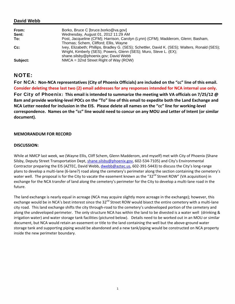
8am and provide working‐level POCs on the “To” line of this email to expedite both the Land Exchange and NCA Letter needed for inclusion in the EIS. Please delete all names on the “cc” line for working‐level correspondence. Names on the “cc” line would need to concur on any MOU and Letter of Intent (or similar document). MEMORANDUM FOR RECORD DISCUSSION: While at NMCP last week, we (Wayne Ellis, Cliff Schem, Glenn Madderom, and myself) met with City of Phoenix (Shane Silsby, Deputy Street Transportation Dept, [email protected], 602‐534‐7105) and City’s Environmental Contractor preparing the EIS (AZTEC, David Webb, [email protected], 602‐391‐5443) to discuss the City’s long‐range plans to develop a multi‐lane (6‐lane?) road along the cemetery’s perimeter along the section containing the cemetery’s water well. The proposal is for the City to vacate the easement known as the “32nd Street ROW” (VA acquisition) in exchange for the NCA transfer of land along the cemetery’s perimeter for the City to develop a multi‐lane road in the future. The land exchange is nearly equal in acreage (NCA may acquire slightly more acreage in the exchange); however, this exchange would be in NCA’s best interest since the 32nd Street ROW would bisect the entire cemetery with a multi‐lane city road. This land exchange shifts the city through‐road to the cemetery’s undeveloped portion of the cemetery and along the undeveloped perimeter. The only structure NCA has within the land to be divested is a water well (drinking & irrigation water) and water storage tank facilities (pictured below). Details need to be worked out in an MOU or similar document, but NCA would retain an easement or title to the land containing the well but the above‐ground water storage tank and supporting piping would be abandoned and a new tank/piping would be constructed on NCA property inside the new perimeter boundary.

2
Existing water storage tank & piping on NMCA property. The well is just behind tank. I took the picture within the cemetery GS development area. It is in the best interest of NCA for this land exchange to occur as soon as possible since NMCA has a casket/ niche depletion of 2019/ 2018, respectively, as supported by both the MSN and NCA FY11 Statistical Summary. The next area for contiguous GS development is within the 32nd Street ROW land. Funding & Construction for GS expansion would likely occur in the FY14/15 timeframe to ensure an uninterrupted full‐option burial inventory. As I understand it, the 32nd Street ROW, owned by the City of Phoenix, is titled to the United States of America, the same as if VA were to own the property. City Officials (POC’s provided above in para 1) are also on‐board for this land exchange as soon as possible since it directly affects alternatives in the EIS. Furthermore, the City is looking for NCA to sign a Letter of Intent (or similar document) to express it is NCA’s intent to acquire the 32nd Street ROW in exchange for giving up nearly equal acreage at the undeveloped cemetery perimeter. The City [AZTEC] is currently developing a draft of the letter and the letter is needed for inclusion in the EIS and for any Public Hearings. I have included this land action in the FY13 Minor DRAFT Operating Plan as an under‐threshold project for CFM required DD activities. This action is forwarded to CFM Real Property Service and was previously listed as an NCA Land Action on Lynn Harrison’s list, June 2011. Bruce Borko Design & Construction Office
Click here to report this email as spam.