title 16 development division ii. zoning districts
TRANSCRIPT

Heading 1
Title 16 DEVELOPMENT Chapters:Division I. General Provisions16.04 Introductory Provisions16.08 Definitions Division II. Zoning Districts16.12 Establishment of Zones16.16 Low Density Residential (R-1)16.20 Medium Density Residential (R-2)16.24 Multiple Family Residential (R-3)16.28 General Commercial (C-1)16.32 Residential Commercial (C-2)16.36 Light Industrial (M-1)16.40 Heavy Industrial (M-2)16.44 Open Space/Public Facilities (O/S)16.48 Historic Resources (H-R)16.52 Planned Development (P-D)16.56 Wetlands Overlay (W/O) Division III. Zoning Regulations16.60 Supplementary Regulations16.64 Adult Businesses16.68 Natural Hazard Areas16.72 Signs16.76 Off-Street Parking and Loading16.80 Temporary Uses16.84 Nonconforming Uses and Structures16.88 Conditional Uses16.92 Home Occupations16.96 Mobilehome and Recreational Vehicle Parks16.100 Variances16.101 Zone ChangesDivision IV. Division of Land
http://www.cityofestacada.org/code/es16tx.htm (1 of 100)8/17/2006 2:37:17 AM

Heading 1
16.104 Division of Land16.108 Tentative Plans16.112 Final Plans16.116 Design Standards and Improvements16.120 Partitions Division V. Annexations16.124 Annexations Division VI. Administrative Provisions16.128 Amendments16.132 Administration16.136 Enforcement Division I. General Provisions Chapter 16.04 INTRODUCTORY PROVISIONS Sections:16.04.010 Short title.16.04.020 Purpose.16.04.030 Compliance with development code provisions.16.04.040 Applicability. 16.04.010 Short title. This title shall be known as the “city development code.” (Prior code § 10.200) 16.04.020 Purpose. The purpose of this title is to promote the public health, safety and general welfare and to assist in the implementation of the comprehensive plan for the city. (Prior code § 10.201) 16.04.030 Compliance with development code provisions. A. A lot may be used and a structure or part of a structure may be constructed, altered, occupied or used only as this title permits.
http://www.cityofestacada.org/code/es16tx.htm (2 of 100)8/17/2006 2:37:17 AM

Heading 1
B. No lot area, yard, off-street parking or loading area, or other open space existing on or after the effective date of this title shall be reduced below the minimum required for it. C. No lot area, yard, off-street parking or loading area, or other required open space for one use shall be used as the required lot area, yard, off-street parking or loading area, or other required open space for another use. D. Building Permit Approvals. No building or structure shall be erected, enlarged, altered, re-built, remodeled or moved unless in conformance with the requirements of all state and local ordinances applicable to the structure and the land upon which it is or will be situated. E. Authorization of Similar Uses. The planning commission may permit in a particular zone a use not listed in the code, provided the use is compatible with the uses permitted there by this title. However, this section does not authorize the inclusion in a zone where it is not listed, a use specifically listed in another zone or which is of the same general type and is similar to a use specifically listed in another zone. F. Conformity to Master Plans. Upon adoption by the city council, the master plans, including, but not limited to, sewer, water, streets, storm drainage and parks shall govern new subdivisions in all zones. Any buildings, structures and their building service equipment to which additions, alterations or repairs are made shall comply with all the requirements of the adopted master plans for new facilities except as provided for in this development code. (Ord. 2000-9 § 1, prior code § 10.210) 16.04.040 Applicability. A. Effects on Other Ordinances. To the extent any provisions of this title conflict with the provisions of previously adopted city ordinances or as any of them as amended, the terms of this title shall govern. B. Applicability. When the conditions imposed by any provision of this title are less restrictive than comparable conditions imposed by any other provisions of this title or of any other ordinance, resolution or regulation, the provisions which are more restrictive shall govern. C. Severability. The provisions of this title are severable. If any section, sentence, clause or phrase of it is adjudged by a court of competent jurisdiction to be invalid, the decision shall not affect the validity of the remaining portions of this title. (Prior code § 10.890) Chapter 16.08 DEFINITIONS Section:16.08.010 Definitions. 16.08.010 Definitions.
http://www.cityofestacada.org/code/es16tx.htm (3 of 100)8/17/2006 2:37:17 AM

Heading 1
As used in this title, the singular includes the plural and the masculine the feminine and neuter; the word “may” is discretionary; the word “shall” is mandatory. The following words and phrases shall mean as follows: “Access” means the way or means by which pedestrians and/or vehicles enter and leave property. “Accessory structure or use” means a structure or use incidental and subordinate to the main use of a property and located on the same lot as the main use. “Adult foster care” means any family home or facility in which twenty-four (24) hour care is provided for five or fewer adults who are not related to the provider by blood or marriage. “Airport” means a tract of land or water that is maintained for the landing and take-off of aircraft and for receiving and discharging passengers and cargo and the repair, storage, supplying of aircraft and providing supplies to aircraft. “Alley” means a public way, for the purpose of providing a secondary means of access to property. “Apartment” means any building, or portion thereof, which is designated, built, rented, leased, let or hired out to be occupied, or which is occupied as the home or residence of four or more families living independently of each other and doing their own cooking in the building. Automobile. 1. “Repair garage” is a use providing for the major repair and maintenance of motor vehicles and includes major mechanical and body work, straightening of body parts, painting, welding or storage of motor vehicles not in operating condition. 2. “Service station” means any premise used for any or all of the following: supplying gasoline, oil, accessories and services, and auto repair work, excluding body and fender repair, at retail direct to the customer and where inoperative car storage is limited to thirty (30) days. 3. “Wrecking yard” means any property where two or more vehicles not in running condition, or the parts thereof, are stored in the open and are not being restored to operation; or any land, building or structure used for the wrecking or storing of such motor vehicles or the parts thereof. 4. “Auto detail shop” includes any or all of the following uses: (a) shampoo and cleaning of carpet and seats; (b) complete interior cleaning; (c) clean and vacuum trunks; (d) cleaning and treatment of vinyl and rubber surfaces; (e) machine buffing and waxing of exterior and chrome; (f) hand wash exterior; (g) clean and polish tires and wheels; (h) engine and compartment cleaning; and (i) decal and paint striping. “Base flood (100-year flood)” means a flood having a one percent chance of being equaled or exceeded in any given year. “Bed and breakfast inns” means an owner-occupied or resident operated single-family dwelling, in a portion of which lodging and breakfast are provided for compensation in accordance with all conditional use provisions for bed and breakfast inns. “Caretaker/manager residence” means a residence, secondary to the main use of the property, for the sole purpose of providing living quarters for the owner, operator or caretaker of an ongoing commercial or industrial enterprise.
http://www.cityofestacada.org/code/es16tx.htm (4 of 100)8/17/2006 2:37:17 AM

Heading 1
“Church” means a building, together with its accessory building or uses, where persons regularly assemble for worship; and which building, together with its accessory buildings and uses, is maintained and controlled by a religious body organized to sustain public worship, and meets tax exemption status as prescribed in Chapter 307 of the Oregon Revised Statutes. “Clinic” means a building utilized by persons licensed in the state of Oregon to treat or analyze medical, dental or surgical needs of humans or animals on an out-patient basis. “Commercial use” means the activity of purchasing, selling or conducting other transactions involving the handling or disposition, other than included in the term light and heavy “industry” as defined in the appropriate sections, of any article, substance, commodity or services for the livelihood or profit, and places where commodities, services or merchandise are sold or agreements are made to furnish them. “Commission” means the Estacada planning commission. “Common property” means a parcel of land, together with improvements that are to be used, maintained and enjoyed by the owners and occupants of the individual building units or sites in subdivisions with common open space, planned development or planned unit subdivisions. “Community center” means a facility owned and operated by a governmental agency or a nonprofit community organization; provided, that the primary purpose of the facility is for recreation, social welfare, community improvement, or public assembly. “Comprehensive plan” means the adopted comprehensive plan for Estacada as defined in ORS Chapter 197. “Council” means the city council of Estacada. “Day care facility” means a facility accommodating fewer than thirteen (13) children for the purposes of day care in the provider’s home, or meeting the definition and standards as contained in ORS 418. The provider’s children are included for the purposes of this definition. Deck, Unenclosed. “Unenclosed deck” means a non-covered attached or unattached structure accessory to the main use of the property, having no components necessary to the structural support of the main use. Deck, Enclosed. “Enclosed deck” means a covered attached or unattached structure accessory to the main use of the property, having no components necessary to the structural support of the main use. “Density” means the number of dwelling units allowed within a specified land area. “Development” means any manmade change or improvement involving buildings, structures, mining, dredging, filling, grading, paving, excavation, drilling, partitioning or subdividing. “Duplex” means a building containing two dwelling units. “Dwelling” means a building or portion thereof designed for residential occupancy. 1. Dwelling, Single-Family. “Single-family dwelling” means a detached dwelling designed or used exclusively for the occupancy of one family and having housekeeping facilities for one family. 2. Dwelling, Multifamily (Duplex). “Multifamily duplex dwelling” means a building designed for the occupancy of two families living independently of each other. 3. Dwelling, Multifamily. “Multifamily dwelling” means a building designed for the occupancy of
http://www.cityofestacada.org/code/es16tx.htm (5 of 100)8/17/2006 2:37:17 AM

Heading 1
three or four families. a. Dwelling, Commonwall. “Commonwall dwelling” means a dwelling which shares at least one wall, or portion thereof, with another dwelling and which is allowed in a residential district subject to the same requirements as dwellings in those districts. A commonwall dwelling may, or may not, include a separate lot. “Dwelling unit” means a building or portion thereof with one or more rooms designed for occupancy by one family for living purposes which provides a minimum of two hundred (200) square feet of floor area per resident. “Easement” means a right of use over the property of another. “Enclosed” means activities which take place entirely within a structure or building, excluding parking and off-loading facilities. “Factory-built dwelling” means a dwelling unit built substantially or entirely at a place other than the residential site, including prefabricated or modular homes, inspected and certified as having been constructed in accordance with the requirements of the Uniform Building Code but excluding mobilehomes or manufactured homes as defined in ORS 446.003(26)(a)(B) and (C). “Family” means any one of the following groups when living together in a single dwelling unit: 1. Persons related by blood, marriage, legal adoption or guardianships, plus not more than six additional persons, including foster and shelter care children; 2. Up to six unrelated persons; or 3. Members of a “residential home,” as defined in this chapter. Each additional group described above, or portion thereof, shall be considered a separate family. “Fence” means an accessory structure, including landscape planting, designed and intended to serve as a barrier or as a means of enclosing a yard or other area, or other structure, or to serve as a boundary feature separating two or more properties. Fence, Sight-Obscuring. “Sight-obscuring fence” consists of either a continuous fence, wall, slated cyclone fence, evergreen planting, or combination thereof, constructed and/or planted so as to effectively screen the particular use from view. Fences, hedges and walls cannot exceed six feet in height. Fences described above are subject to clear vision regulations of Section 16.60.010. “FIRM” means Flood Insurance Rate Maps that delineate both the area of special flood hazard and risk premium zones. “Flag lot” means a lot, the major portion of which has access to a road or street by means of a narrow strip of land called the “staff.” The staff shall have a minimum width and frontage of not less than twenty-five (25) feet. The staff portion of a flag lot shall not be used in computing lot size for zoning and building purposes. “Flood/flooding” means a general and temporary condition of partial or complete inundation of normally dry land areas from: 1. The overflow of inland or tidal waters; and/or
http://www.cityofestacada.org/code/es16tx.htm (6 of 100)8/17/2006 2:37:17 AM

Heading 1
2. The unusual and rapid accumulation of runoff or surface waters from any source. “Floodplain” means the area shown on designated maps for the city as being subject to inundation by delineation of a base flood as determined by the U.S. Army Corps of Engineers or other means. “Heavy industry” means the manufacturing, processing, compounding, packaging or assembling of products, the process of which requires or creates emissions or discharges other than normal sanitary sewage wastes or the storage of materials which require permits be issued by the Oregon State Department of Environmental Quality. “Home occupation” means an occupation carried on within a dwelling, or an accessory structure by a resident of the dwelling, where such occupation is secondary to the main use of the property as a residence, but excluding commercial businesses considered by the planning commission as inappropriate for residential areas. “Hospital” means an establishment which provides sleeping and eating facilities to persons receiving medical, obstetrical or surgical care with nursing service on a continuous basis. “Hotel” means a building that is designed or used to offer short-term lodging for compensation, with or without meals, for five or more people. A facility that is operated for the purpose of providing care beyond that of room and board is not a “hotel.” “Junk yard” means any property utilized for breaking up, dismantling, sorting, storing, distributing, buying or selling of any scrap waste material, junk or used equipment or machinery of any nature. “Kennel” means a lot or building which provides for the keeping of four or more dogs, cats or animals at least six months of age, where such animals are kept for purposes other than a veterinary clinic. “Landscaping” means a compatible combination of natural and/or introduced vegetation and materials which provide visual enhancement to a development. “Landscaping plan” means a schematic or plot plan which indicates: 1. Areas of landscaping, including percent of lot area; 2. Type(s) of vegetation and/or materials; 3. Maintenance type and schedule, i.e., irrigation method. “Light industry” means the manufacturing, processing, compounding, packaging or assembling of products, the process of which does not require or create emissions or discharges other than normal sanitary sewage wastes or the storage of materials which require permits be issued by the Oregon State Department of Environmental Quality. “Livestock” mean domestic animals and fowl or types customarily raised or kept on farms for profit or other purposes. This definition does not include domesticated household pets such as dogs or cats. “Loading space” means an off-street space or berth on the same lot or parcel with a building or use, or contiguous to a group of buildings or uses, for the temporary parking of a vehicle while loading or unloading persons, merchandise or materials, and which space or berth abuts on a street, alley or other appropriate means of access. “Lot” means a parcel or tract of land which is occupied or may be occupied by a structure or a use,
http://www.cityofestacada.org/code/es16tx.htm (7 of 100)8/17/2006 2:37:17 AM

Heading 1
together with yards and other open space and meets the definition of “lot of record.” “Lot area” means the total horizontal area within the lot lines of a lot, exclusive of streets. The staff portion of a flag lot shall not be used in computing the size or area of the lot for zoning or building purposes. Lot, Corner. “Corner lot” means a lot abutting on two or more streets other than an alley, at their intersection. A lot abutting on a curved street or streets shall be considered a corner lot if straight lines drawn from the foremost points of the side lot lines to the foremost point of the lot meet at an interior angle of less than one hundred thirty-five (135) degrees. “Lot depth” means the average horizontal distance between the front lot line and the rear line. “Lot frontage” means the front of a lot shall be construed to be the portion nearest the street. For the purpose of determining yard requirements on corner lots and through lots, all sides of a lot adjacent to a street other than an alley shall be considered frontage, and yards shall be provided as indicated in this section. Lot, Interior. “Interior lot” means a lot other than a corner lot with only one frontage on a street. “Lot line” means the property line bounding a lot. Lot Line, Front. “Front lot line” means the property line separating the lot from the street, other than an alley. In the case of a corner lot, the shortest property line along a street, other than an alley; or, in a case where the lot does not front directly upon a public street, that lot line toward which most houses in the immediate area face. Lot Line, Rear. “Rear lot line” means the lot line or lines opposite and most distant from the front lot line. Lot Line, Side. “Side lot line” means any lot line or lines not a front or rear lot line. “Lot of record” means any unit of land created as follows: 1. A lot in a platted subdivision; 2. A lot created by land partitioning; 3. A unit of land described by a conveyed deed or land sales contract established prior to requirements for partitions and which conformed with all zoning requirements in effect, if any, when the deed or contract creating the lot was recorded. Lot of Record, Nonconforming. “Nonconforming lot of record” means a parcel of land which lawfully existed as a lot in compliance with all applicable ordinances and laws at the time of creation, but which, because of the application of a subsequent zoning ordinance, no longer conforms to the lot dimension requirement for the zoning district in which it is located. Lot, Through. “Through lot” means an interior lot abutting on streets, other than an alley, on both of the opposite, exterior lot lines. “Lot width” means the average horizontal distance between the side lot lines, ordinarily measured parallel to the front lot line. “Manager/caretaker residence” means a residence, secondary to the main use of the property, for the
http://www.cityofestacada.org/code/es16tx.htm (8 of 100)8/17/2006 2:37:17 AM

Heading 1
sole purpose of providing living quarters for the owner, operator or caretaker of an ongoing commercial or industrial enterprise. “Manufactured home” means a dwelling unit built substantially or entirely at a place other than the residential site as defined in ORS 446.003(26)(a)(C). “Manufactured dwelling park” means a parcel or contiguous parcels of land divided into four or more manufactured home lots for rent or lease, under the same ownership. “Marina” means a commercial boat launch, moorage or similar facility which may include dry or wet boat storage, boat houses and related commercial activities. “Mine quarry” means premises from which any rock, sand, gravel, stone, topsoil, clay, mud, peat, or other mineral is removed or excavated as an industrial or commercial operation, and exclusive of excavating and grading for streets and roads and process of grading a lot preparatory to the construction of a building for which a permit has been issued by a public agency. “Mini-warehouse (storage)” means a structure used for storing personal effects or small retail merchandise with individual compartments that do not exceed one thousand (1,000) square feet. “Mobilehome” means a single-family dwelling unit built substantially or entirely at a place other than the residential site as defined in ORS 446.003(26)(B). “Mobilehome park” means a parcel or contiguous parcels of land divided into four or more mobilehome lots for rent or lease, under the same ownership. “Motel” means a building or series of buildings in which lodging only is offered for compensation and which may have more than five sleeping rooms or units for this purpose and which is distinguished from a hotel primarily by reason of providing direct independent access to and adjoining parking for each rental unit designed primarily for automobile tourists and transient persons. The term includes auto courts, tourist courts, tourist homes and motor lodges. “Nonconforming structure/use” means use of structure or land, or structure and land in combination which was lawfully established in compliance with all applicable ordinances and laws, but which because of the application of a subsequent zoning ordinance: (1) no longer conforms to the setback, height, maximum lot coverage or other building development requirements of this title; or (2) is clearly designed and intended for uses other than any use permitted in the zoning district in which it is located. “Open space” means the area within the development designed and intended for the use or enjoyment of all residents of the development or for the use and enjoyment of the public in general. Open space includes the land area to be used for scenic, landscaping or open recreation purposes within the development. It shall not include street right-of-way, driveways or open parking areas. “Owner” means the owner of a record of real property as shown on the tax rolls of the county, or a person who is purchasing a parcel of property under contract. “Parcel” means a unit of land that is created by a partitioning of land. “Park” means an open or enclosed tract of land set apart and devoted for the purposes of pleasure, recreation, ornament, light and air for the general public.
http://www.cityofestacada.org/code/es16tx.htm (9 of 100)8/17/2006 2:37:17 AM

Heading 1
“Parking space” means an off-street enclosed or unenclosed surfaced area of not less than eighteen (18) feet by eight feet, exclusive of maneuvering and access area, permanently reserved for the temporary storage of one automobile, connected with a street or alley which affords access for automobiles. “Partition” means either an act of partitioning land or an area or tract of land partitioned as defined in ORS. Chapter 92. “Partition land” means to divide an area or tract of land into two or three parcels within a calendar year when such area or tract of land exist as a unit or contiguous units of land under single ownership at the beginning of such year, and does not include exceptions as outlined in ORS 92.010(7). “Partition plat” means a final map and other writing containing all the descriptions, locations, specifications, provisions and information concerning a partition. “Performance agreement” means a bond executed by a surety company licensed in the state of Oregon, or other security acceptable to the city, to insure completion of the conditions of approval. “Person” means a natural person, the heirs, executors, administrators or assigns, or a firm, partnership or corporation, successors or assigns, or the agent of any of the aforesaid, or any political subdivisions, agency, board or bureau of the state. “Pier” means a fixed moorage facility constructed outward from the river bank. “Planned development” means a development in which the applicable code restrictions, other density requirements, may be modified and/or applied to the development as a whole rather than to each individual lot. A planned development involving the subdividing of property is a planned unit development. “Planned unit subdivision” means a subdivision of land in which the individual building sites may be reduced in size but are compensated by area used in common for recreational or other open space purposes. Planned unit subdivisions involving dwelling or commercial units may incorporate detached, semi-detached, attached, single-story or multistoried units or any combination of the aforementioned. Such projects may also involve religious, cultural, recreational and commercial uses and purposes. “Planning commission” means the planning commission of the city of Estacada. “Plat” means a final subdivision plat, replat or partition plat. “Principal use” means the intended and primary use of a structure or parcel of land. “Private road” means a privately owned road where public access and use is by permission of the property owner. “Public utility” means any corporation, company, individual, association of individuals, or its lessees, trustees or receivers, that owns, operates, manages or controls all or any part of any plant or equipment for the conveyance of telegraph, telephone, with or without wires, for the transportation as common carriers, or for the production, transmission, delivery or furnishing of heat, light, water, power or cable services, directly or indirectly to the public. “Public utility workshop” means a building used for the repair and/or maintenance of utility vehicles, machinery or other equipment.
http://www.cityofestacada.org/code/es16tx.htm (10 of 100)8/17/2006 2:37:17 AM

Heading 1
“Recreational vehicle (R.V.)” means a temporary dwelling, for travel and recreation purposes, and licensed as a motor home, camper or travel trailer. “Recreational vehicle park” means a development designed primarily for transient service in which travel trailers, pick-up campers, tent trailers and self propelled motorized vehicles are parked and used for the purpose of supplying to the public a temporary location while traveling, vacationing or recreating. “Replat” means the act of platting the lots, parcels and easements in a recorded subdivision or partition plat to achieve a re-configuration of the existing subdivision or partition plat or to increase or decrease the number of lots in the subdivision. “Residential home” means any dwelling unit or residential building operated as a single housekeeping unit for the purpose of providing food, shelter, personal services and care, as defined in the ordinance codified in this chapter, and when appropriate, a planned treatment or training program of counseling, therapy, or other rehabilitative social service, for persons of similar or compatible conditions of circumstances. “Road” means a public or private way created to provide ingress to, or egress from, one or more lots, parcels, areas or tracts of land, or that provides for travel between places by vehicles. The terms “street”, “access drive” and “highway” for the purposes of the ordinance codified in this chapter shall be synonymous with the term “road.” 1. “Arterial or major highway” means a street designed to carry traffic from one community to another, to carry traffic to and from major traffic generators and to carry through traffic. 2. “Collector or secondary street” means a street designed to carry traffic between minor streets and the arterial system, to function as primary traffic carries within a neighborhood, to carry traffic to local traffic generators, and in commercial and industrial areas, to provide access to commercial and industrial properties. 3. “Cul-de-sac” or “dead end street” means a minor street with only one outlet which provides a vehicular turnaround. 4. “Minor street” means a street designed to provide access to abutting residential property with only incidental service to through traffic. 5. “Private road” means a private road created by deed or easement to provide vehicular ingress to, or egress from, three to six dwelling units. Any road serving more than six dwelling units must be a public road. Private roads may serve development when approved by the planning commission upon written findings that such roads are of adequate width, alignment, grade and length to afford the same degree of public safety as public roads and that extension of the public road system is impractical. In determining if the extension of the public road system is impractical, the planning commission shall consider criteria including, but not limited to, lot size or shape, topography, the location of existing structures. In no case shall a private street be less than twenty (20) feet in width. Greater width may be required where necessary to provide for public safety, accommodate traffic volume, or provide for underground utilities. A street maintenance agreement approved by the city and duly recorded, shall be required for the creation of any
http://www.cityofestacada.org/code/es16tx.htm (11 of 100)8/17/2006 2:37:17 AM

Heading 1
private road. 6. “Public road” means a road dedicated for public use. 7. “Access drive” means a private road, with a travel surface not less than twelve (12) feet in width, created by deed or easement to provide vehicular ingress, or egress from not more than two lots or parcels. “School” means any institution for learning, whether public or private, meeting state of Oregon accreditation standards. “Setback” means the horizontal distance measured perpendicular from the lot line to the nearest point of any structure on the lot or parcel. 1. Front: a setback between side lot lines and measured horizontally at right angles to the front line from the front lot line to the nearest point of a building. Any yard meeting this definition and abutting on a street other than an alley, shall be considered a front yard. 2. Rear: a setback between side lot lines and measured horizontally at right angles to the rear lot line from the rear lot line, to the rear most part of the main building. 3. Side: a setback between the front and rear yard measured horizontally and at right angles from the side lot line to the nearest point of the main building. “Sign” means an identification, description, illustration or device which is affixed to or represented, directly or indirectly, upon a building, structure or land, and which directs attention to a product, place, activity, person, institution or business. Street. (See “Road”). “Structure” means a structure built or assembled for any use or occupancy. “Subdivided land” means to divide an area or tract of land into four or more lots within a calendar year when such an area or tract of land exists as a unit of contiguous units of land under a single ownership at the beginning of a year. “Subdivision” means an area or tract of land divided into four or more lots within a calendar year. “Subdivision plat” includes a final map and other writing containing all the descriptions, locations, specifications, dedications, provisions and information concerning a subdivision. “Tentative plan” means an approved diagram showing the design of a proposed partition or subdivision, together with any other writing and information that may be required. “Temporary” means a specific period of time. “Unit of ownership” means an area or tract of land described by a deed or by metes and bounds as a single entity. “Use” means the purpose for which a structure is designed, arranged or intended; or for which land is maintained, occupied or zoned. “Water-dependent” means a use or activity which can be carried out only on, in or adjacent to water areas because the use requires access to the water body for water-borne transportation, recreation, energy production or source of water. “Wetlands” means those areas that are inundated or saturated by surface or ground water at a frequency
http://www.cityofestacada.org/code/es16tx.htm (12 of 100)8/17/2006 2:37:17 AM

Heading 1
and duration that are sufficient to support, and that under normal circumstances do support, a prevalence or vegetation typically adapted for life in saturated soil conditions. “Wholly enclosed” means everything is completely within a building. (Ord. 2004-2 § 1; Ord. 2003-8 § 1; Ord. 2000-25 §§ 2, 3; editorially amended during 2000 codification; prior code § 10.202)
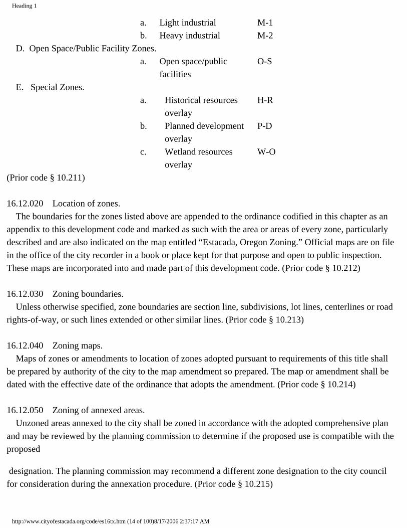
Division II. Zoning Districts Chapter 16.12 ESTABLISHMENT OF ZONES Sections:16.12.010 Classification of zones.16.12.020 Location of zones.16.12.030 Zoning boundaries.16.12.040 Zoning maps.16.12.050 Zoning of annexed areas.16.12.060 Zone descriptions. 16.12.010 Classification of zones. For the purpose of this title, the following zones are established in the city: Map Designations and Abbreviations. A. Residential Zones.
a. Residential R-1 Low density residential
b. Residential R-2 Medium density residential
c. Residential R-3 Multiple family residential
B. Commercial Zones. a. General commercial C-1 b. Residential/ commercial C-2
C. Industrial Zones.
http://www.cityofestacada.org/code/es16tx.htm (13 of 100)8/17/2006 2:37:17 AM
Heading 1
a. Light industrial M-1 b. Heavy industrial M-2
D. Open Space/Public Facility Zones. a. Open space/public
facilitiesO-S
E. Special Zones. a. Historical resources
overlayH-R
b. Planned development overlay
P-D
c. Wetland resources overlay
W-O
(Prior code § 10.211) 16.12.020 Location of zones. The boundaries for the zones listed above are appended to the ordinance codified in this chapter as an appendix to this development code and marked as such with the area or areas of every zone, particularly described and are also indicated on the map entitled “Estacada, Oregon Zoning.” Official maps are on file in the office of the city recorder in a book or place kept for that purpose and open to public inspection. These maps are incorporated into and made part of this development code. (Prior code § 10.212) 16.12.030 Zoning boundaries. Unless otherwise specified, zone boundaries are section line, subdivisions, lot lines, centerlines or road rights-of-way, or such lines extended or other similar lines. (Prior code § 10.213) 16.12.040 Zoning maps. Maps of zones or amendments to location of zones adopted pursuant to requirements of this title shall be prepared by authority of the city to the map amendment so prepared. The map or amendment shall be dated with the effective date of the ordinance that adopts the amendment. (Prior code § 10.214) 16.12.050 Zoning of annexed areas. Unzoned areas annexed to the city shall be zoned in accordance with the adopted comprehensive plan and may be reviewed by the planning commission to determine if the proposed use is compatible with the proposed
designation. The planning commission may recommend a different zone designation to the city council for consideration during the annexation procedure. (Prior code § 10.215)
http://www.cityofestacada.org/code/es16tx.htm (14 of 100)8/17/2006 2:37:17 AM

Heading 1
16.12.060 Zone descriptions. A. Residential R-1 low density residential: devoted to single-family dwellings from which are excluded business and multiple-dwelling structures but does allow certain public nonprofit uses as conditional uses, as well as home occupations, and bed and breakfast facilities with standards. B. Residential R-2 medium density residential: created to allow single-family and two-family dwellings. Intended for residential use at a moderate density and utilize existing subdivided lots with affordable housing. C. Residential R-3 multiple-family residential: intended for residential use as a high density residential district allowing some conditional uses with standards. D. General commercial C-1: intended for certain commercial uses as well as governmental uses such as city halls, fire stations, police stations and offices. Commercial uses intended for office, service and retail uses primarily conducted inside the building. This zone is determined to be economically and socially desirable. E. Residential commercial C-2: designed for a mixture of office, retail, personal or business service, plus allowing residential uses. C-2 was created to promote the most productive capacity of property. Several areas of the city have developed into a combination of residential and commercial use zones. The purpose of this zoning district is to recognize and to continue this development pattern. F. Light industrial M-1: created for the expansion of light industrial uses. Permits wholly enclosed light industrial uses and compatible commercial uses which are compatible to the surrounding area. G. Heavy industrial zone M-2: created in the interest of the public convenience and necessity for outright industrial development m order to more widely advertise the attributes and amenities available in Estacada for industrial uses. H. Open space/public facilities zone O-S: created to ensure public greenways, pathways and parks, to allow governmental uses including public schools and allowing them to expand as outright uses, providing it would not substantially increase overall capacity and are in harmony with the purpose and objectives of the comprehensive plan. I. Planned Development Zone P-D. The purpose of the planned development overlay zone is to permit the application of new technology and greater freedom than may be possible under a strict interpretation of the provisions of the code. J. Historical Resources Overlay Zone H-R. The intent and purpose of this overlay district is to implement the goals and policies of the comprehensive plan and encourage property owners to enhance and maintain historically designated resources within the community. K. Wetlands Resources Overlay Zone W-O. The intent and purpose of this overlay is to implement the goals and policies of the comprehensive plan and protect the designated wetland resources within the community. (Prior code § 10.218)
http://www.cityofestacada.org/code/es16tx.htm (15 of 100)8/17/2006 2:37:17 AM

Heading 1
Chapter 16.16 LOW DENSITY RESIDENTIAL (R-1) Sections:16.16.010 Low density residential zone (R-1).16.16.020 Uses permitted outright.16.16.030 Conditional uses permitted.16.16.040 Standards.16.16.050 Exceptions to standards. 16.16.010 Low density residential zone (R-1). Devoted to single-family dwellings from which are excluded business and multiple-dwelling structures but does allow certain public nonprofit uses as conditional uses, as well as home occupations, and bed and breakfast facilities with standards. In an R-1 zone, the following regulations shall apply. (Ord. 2000-26 §1 (part): prior code § 10.220 (part)) 16.16.020 Uses permitted outright. The following uses and their accessory uses are permitted in an R-1 zone: A. A one-family dwelling built on site; B. A factory-built dwelling; C. Manufactured homes that meet the following minimum standards: 1. Compliance with all the standards as set by the underlying zoning district, 2. The manufactured home shall be multisectional and enclose a space of not less than one thousand (1,000) square feet, 3. The manufactured home shall be placed on an excavated and back-filled foundation and enclosed at the perimeter such that no more than sixteen (16) inches of the enclosing material is exposed above grade. Where the building site has a sloped grade, no more than sixteen (16) inches of the enclosing material shall be exposed on the uphill side of the home. If the manufactured home is placed on a basement, the sixteen (16) inch limitation shall not apply, 4. The manufactured home shall have a pitched roof with a minimum slope of three feet in height for each twelve (12) feet of width, 5. The manufactured home shall be certified by the manufacturer to have an exterior thermal envelope meeting the performance standards which reduce heat loss to levels equivalent to the performance standards required of single-family dwellings constructed under the state building code as defined in ORS 455.010. Evidence demonstrating that the manufactured home meets “Super Good Cents” energy efficiency standards is deemed to satisfy the exterior thermal envelope certification requirement.
http://www.cityofestacada.org/code/es16tx.htm (16 of 100)8/17/2006 2:37:17 AM

Heading 1
Additional manufacturer certification shall not be required; D. Agricultural use of land provided that no livestock shall be raised or kept on the premises and that no commercial structure shall be constructed or maintained on the premises; E. A travel trailer or recreation vehicle stored unoccupied on a lot in combination with an approved dwelling and complies with residential setback requirements; F. Family day care provider; G. Public park; H. Residential homes; I. Home occupations as defined in Chapter 16.92 that involve no customer traffic, retail sales, signs or any other outward appearance of a business. (Ord. 2000-26 § 1(1): prior code § 10.220(1))16.16.030 Conditional uses permitted. The following uses and accessory uses may be permitted in a low density residential district subject to Section 16.88.020 and the review procedures in Sections 16.132.010 through 16.132.050: A. Duplexes and commonwall dwellings; B. Cemetery; C. Church, nonprofit religious or philanthropic institution; D. Community center, nursery school, kindergarten or similar facility; E. Governmental structure or use of land; F. Public utility substations as required with safeguards against harm to adjacent or abutting property owners; G. Home occupations subject to the provisions of Chapter 16.92; H. Golf course or country club, but excluding miniature golf course or similar types of amusement facilities; I. Private noncommercial recreation club such as tennis, swimming or archery club, but excluding commercial amusement or recreation enterprises; J. Lodge of civic or fraternal organizations; K. Public school or private school offering curriculum similar to public school and portable or temporary modular classrooms on-site; L. Temporary real estate offices offering residential property in the immediate vicinity for sale, rent or lease; M. Bed and breakfast inns; N. Day care facility as defined in ORS Chapter 418; O. Professional offices or medical facilities. (Ord. 2000-26 § 1(2): prior code § 10.220(2)) 16.16.040 Standards. The following standards shall apply in an R-1 zone: A. Lot Size and Dimensions.
http://www.cityofestacada.org/code/es16tx.htm (17 of 100)8/17/2006 2:37:17 AM

Heading 1
1. The minimum lot size uses shall be seven thousand five hundred (7,500) square feet. 2. In no event shall a structure for a single-family dwelling be built on a lot less than five thousand (5,000) square feet in area. The area of a pre-existing legal lot of record shall be the size of the lot at the time it was lawfully established. 3. The minimum lot area for a duplex and commonwall dwelling approved as a conditional use shall be eight thousand (8,000) square feet. 4. Minimum lot frontage for a flag lot shall be twenty-five (25) feet. 5. No lot area, yard, off-street parking or loading area, or other required open space for one use shall be used as the required lot area, yard, off-street parking or loading area, or other required open spaces for another use. B. Parking Requirements. 1. Dwellings. Two on-site parking spaces shall be provided for each dwelling unit. 2. Uses Other than Dwellings. The number of parking spaces as required by Chapter 16.76 of this code shall be provided. C. Setbacks. 1. The front setback shall be a minimum of twenty (20) feet. 2. Each side setback shall be a minimum of five feet, but any point of a building exceeding fifteen (15) feet in height must have a setback from a side property line equal to or greater than one-third the height of that point. (Height measured from grade level adjacent to the wall that is closest to the side property line.) If a utility easement is required, a minimum of ten (10) feet will be required. 3. The rear setback shall be a minimum of fifteen (15) feet except: a. An accessory structure not used for human habitation and separated from the main building may be located to within five feet of a rear property line. b. On a corner lot, setbacks required from the rear property line shall be the same as required for side yards. D. Sidewalks. Sidewalks, driveways and service driveways shall conform to standards established by this code. E. Fences and sight-obscuring fences: consisting of either a continuous fence, wall, slated cyclone fence, evergreen planting, or combination thereof, constructed and/or planted so as to effectively screen cannot exceed six feet in height. Fences described above are subject to clear vision regulations of Section 16.60.010 and Section 8.08.060 limiting the use of barbed wire and electrical fences. F. Drainage. An applicant for a building permit shall submit a plan showing width, depth, and direction of flow of all drainage channels on property. In addition, the location, size and type of conduit used in drainage channels and driveway accesses shall be clearly delineated. Water from roof drains and other nonimpervious surfaces shall not be concentrated and directed so as to cause damage to property and shall be disposed of in accordance with Section 13.08.010 of this code. G. Excavation/Fill. A plan shall be submitted showing cubic yards removed or filled and the plan
http://www.cityofestacada.org/code/es16tx.htm (18 of 100)8/17/2006 2:37:17 AM
Heading 1
should be certified by a registered professional engineer for the removal or fill of more than fifty (50) cubic yards of material. H. Building Height. No building shall exceed a height of thirty-five (35) feet, except public schools or churches which may be forty-five (45) feet. I. Lot Coverage. Buildings including accessory structures and garages shall not occupy more than fifty-five (55) percent of the total lot area. J. Geological Analysis Requirement. Any property identified as a geological natural hazard area as listed in Section 16.68.030 or any property that has a slope of thirty-three (33) percent or greater, as defined by a 3:1 ratio, 3 horizontal : 1 vertical, will require a geotechnical analysis of the property as outlined in Section 16.68.030. K. Structure and Facade Design. All dwellings, except temporary dwellings approved pursuant to Chapter 16.80, shall include at least three of the following features visible to the street (if on a corner lot, visible to the street where the dwelling takes access): 1. A covered porch at least two feet deep; 2. An entry area recessed at least two feet from the exterior wall to the door; 3. A bay or bow window (not flush with the siding); 4. An offset on the building face of at least sixteen (16) inches from one exterior wall surface to the other; 5. A dormer; 6. A gable; 7. Roof eaves with a minimum projection of twelve (12) inches from the intersection of the roof and the exterior walls; 8. Roof line offsets of at least sixteen (16) inches from the top surface of one roof to the top surface of the other; 9. An attached garage; 10. Orientation of the long axis and front door to the street; 11. Cupolas; 12. Tile or shake roofs; 13. Horizontal lap siding.(Ord. 2004-2 § 3; Ord. 2000-26 § 1(3): prior code § 10.220(3))16.16.050 Exceptions to standards. The standards of this section pertaining to accessory structures and setbacks may be modified as provided for in Sections 16.60.030 through 16.60.050. (Ord. 2000-26 § 1(4): prior code § 10.220(4)) Chapter 16.20
http://www.cityofestacada.org/code/es16tx.htm (19 of 100)8/17/2006 2:37:17 AM

Heading 1
MEDIUM DENSITY RESIDENTIAL(R-2) Sections:16.20.010 Medium density residential zone (R-2).16.20.020 Uses permitted outright.16.20.030 Conditional uses permitted.16.20.040 Standards.16.20.050 Exceptions to standards. 16.20.010 Medium density residential zone (R-2). Created to allow single-family and two-family dwellings. Intended for residential use at a moderate density and to utilize existing subdivided lots with affordable housing. In an R-2 zone, the following regulations shall apply. (Ord. 2000-26 § 2 (part) prior code § 10.221 (part)) 16.20.020 Uses permitted outright. The following uses and their accessory uses are permitted in an R-2 zone: A. A use permitted outright in the R-1 zone; B. Duplexes and two unit commonwall dwellings. (Ord. 2004-2 § 4: Ord. 2000-26 § 2(1): prior code § 10.221(1)) 16.20.030 Conditional uses permitted. The following uses and accessory uses may be permitted in a medium density residential district subject to Section 16.88.020 and the review procedures in Sections 16.132.010 through 16.132.050: A. A use permitted as a conditional use in the R-1 zone; B. Multiple-family dwellings and commonwall dwellings; C. Manufactured home park; D. Mobilehome park; E. Professional offices or medical facilities. (Ord. 2000-26 § 2(2): prior code § 10.221(2)) 16.20.040 Standards. The following standards shall apply in an R-2 zone: A. Lot Size and Dimensions. 1. The minimum lot size shall be as follows:
Single family dwelling 5,000 square feet
http://www.cityofestacada.org/code/es16tx.htm (20 of 100)8/17/2006 2:37:17 AM

Heading 1
Duplex/commonwall dwelling
8,000 square feet
Triplex/commonwall dwelling
9,000 square feet
Fourplex/commonwall dwelling
12,000 square feet
2. Minimum lot frontage for a flag lot shall be twenty-five (25) feet. 3. No lot area, yard, off-street parking or loading area, or other required open space for one use shall be used as the required lot area, yard, off street parking or loading area, or other required open spaces for another use. B. Parking Requirements. 1. Dwellings. Two on-site parking spaces shall be provided for each dwelling unit. 2. Uses Other than Dwellings. The number of parking spaces as required by Chapter 16.76 of this code shall be provided. C. Setbacks. 1. The front setback shall be a minimum of twenty (20) feet. 2. Except as to the common side of a commonwall dwelling, each side setback shallbe a minimum of five feet, but any point of a building exceeding fifteen (15) feet in height must have a setback from a side property line equal to or greater than one-third the height of that point. (Height measured from grade level adjacent to the wall that is closest to the side property line.) If a utility easement is required, a minimum of ten (10) feet will be required. 3. The rear setback shall be a minimum of fifteen (15) feet except: a. An accessory structure not used for human habitation and separated from the main building may be located to within five feet of a rear property line. b. On a corner lot, setbacks required from the rear property line shall be the same as required for side yards. D. Sidewalks. Sidewalks, driveways and service driveways shall conform to standards established by this code. E. Fences and sight-obscuring fences; consisting of either a continuous fence, wall, slated cyclone fence, evergreen planting, or combination thereof, constructed and/or planted so as to effectively screen cannot exceed six feet in height. Fences described above are subject to clear vision regulations of Section 16.60.010 and Section 8.08.060 limiting the use of barbed wire and electrical fences. F. Drainage. An applicant for a building permit shall submit a plan showing width, depth, and direction of flow of all drainage channels on property. In addition, the location, size and type of conduit used in drainage channels and driveway accesses shall be clearly delineated. Water from roof drains and other nonimpervious surfaces shall not be concentrated and directed so as to cause damage to property and
http://www.cityofestacada.org/code/es16tx.htm (21 of 100)8/17/2006 2:37:17 AM

Heading 1
shall be disposed of in accordance with Section 13.08.010 of this code. G. Excavation/Fill. A plan shall be submitted showing cubic yards removed or filled and the plan should be certified by a registered professional engineer for the removal or fill of more than fifty (50) cubic yards of material. H. Building Height. No building shall exceed a height of thirty-five (35) feet, except public schools or churches which may be forty-five (45) feet. I. Lot Coverage. Buildings including accessory structures and garages shall not occupy more than fifty-five (55) percent of the total lot area. J. Geological Analysis Requirement. Any property identified as a geological natural hazard area as listed in Section 16.68.030 or any property that has a slope of thirty-three (33) percent or greater, as defined by a 3:1 ratio, 3 horizontal : 1 vertical, will require a geotechnical analysis of the property as outlined in Section 16.68.030. (Ord. 2000-26 § 2(3): prior code § 10.221(3)) 16.20.050 Exceptions to standards. The standards of this section pertaining to accessory structures and setbacks may be modified as provided for in Sections 16.60.030 through 16.60.050. (Ord. 2000-26 § 2(4): prior code § 10.221(4)) Chapter 16.24 MULTIPLE FAMILY RESIDENTIAL(R-3) Sections:16.24.010 Multiple family residential zone (R-3).16.24.020 Uses permitted outright.16.24.030 Conditional uses permitted.16.24.040 Standards.16.24.050 Exceptions to standards. 16.24.010 Multiple family residential zone (R-3). Intended for residential use as a high density residential district allowing some conditional uses with standards. In an R-3 zone the following regulations shall apply. (Ord. 2000-26 § 3 (part): prior code § 10.222 (part)) 16.24.020 Uses permitted outright. The following uses and their accessory uses are permitted in an R-3 zone:
http://www.cityofestacada.org/code/es16tx.htm (22 of 100)8/17/2006 2:37:17 AM

Heading 1
A. A use permitted outright in the R-1 or R-2 zone; B. Multifamily dwellings and commonwall dwellings; C. Apartments. (Ord. 2000-26 § 3(1): prior code § 10.222(1)) 16.24.030 Conditional uses permitted. The following uses and accessory uses may be permitted in a multiple family district subject to Section 16.88.020 and the review procedures in Sections 16.132.010 through 16.132.050: A. A use permitted as a conditional use in the R-1 or R-2 zone; B. Hotel, motel or resort; C. Recreational vehicle park; D. Hospital, nursing home, retirement home, convalescent care facility or similar facility. (Ord. 2000-26 § 3(2): prior code § 10.222(2)) 16.24.040 Standards. The following standards shall apply in an R-3 zone: A. Lot Size and Dimensions:
Single-family dwelling 5,000 square feetDuplex/commonwall dwelling
8,000 square feet
Triplex/commonwall dwelling
9,000 square feet
Fourplex/commonwall dwelling
12,000 square feet
Apartment (per living unit)
15,000 square feet plus 1,500 square feet per dwelling unit for each unit above five.
Motel, hotel or resorts 1,500 square feet per guest unit
1. Minimum lot frontage for a flag lot shall be twenty-five (25) feet. 2. No lot area, yard, off-street parking or loading area, or other required open space for one use shall be used as the required lot area, yard, off-street parking or loading area, or other required open spaces for another use. B. Parking Requirements. 1. Dwellings. Two on-site parking spaces shall be provided for each dwelling unit.
http://www.cityofestacada.org/code/es16tx.htm (23 of 100)8/17/2006 2:37:17 AM

Heading 1
2. Uses Other than Dwellings. The number of parking spaces as required by Chapter 16.76 of this code shall be provided. C. Setbacks. 1. The front setback shall be a minimum of twenty (20) feet. 2. Except as to the common side of a commonwall dwelling, each side setback shall be a minimum of five feet, but any point of a building exceeding fifteen (15) feet in height must have a setback from a side property line equal to or greater than one-third the height of that point. (Height measured from grade level adjacent to the wall that is closest to the side property line.) If a utility easement is required, a minimum of ten (10) feet will be required. 3. The rear setback shall be a minimum of fifteen (15) feet except: a. An accessory structure not used for human habitation and separated from the main building may be located to within five feet of a rear property line. b. On a corner lot, setbacks required from the rear property line shall be the same as required for side yards. D. Sidewalks. Sidewalks, driveways and service driveways shall conform to standards established by this code. E. Fences and sight-obscuring fences: consisting of either a continuous fence, wall, slated cyclone fence, evergreen planting, or combination thereof, constructed and/or planted so as to effectively screen cannot exceed six feet in height. Fences described above are subject to clear vision regulations of Section 16.60.010 and Section 8.08.060 limiting the use of barbed wire and electrical fences. F. Drainage. An applicant for a building permit shall submit a plan showing width, depth, and direction of flow of all drainage channels on property. In addition, the location, size and type of conduit used in drainage channels and driveway accesses shall be clearly delineated. Water from roof drains and other nonimpervious surfaces shall not be concentrated and directed so as to cause damage to property and shall be disposed of in accordance with Section 13.08.010 of this code. G. Excavation/fill. A plan shall be submitted showing cubic yards removed or filled and the plan should be certified by a registered professional engineer for the removal or fill of more than fifty (50) cubic yards of material. H. Building Height. No building shall exceed a height of thirty-five (35) feet, except public schools or churches which may be forty-five (45) feet. I. Lot Coverage. Buildings including accessory structures and garages shall not occupy more than fifty-five (55) percent of the total lot area. J. Geological Analysis Requirement. Any property identified as a geological natural hazard area as listed in Section 16.68.030 or any property that has a slope of thirty-three (33) percent or greater, as defined by a 3:1 ratio, 3 horizontal : 1 vertical, will require a geotechnical analysis of the property as outlined in Section 16.68.030. (Ord. 2000-26 § 3(3): prior code § 10.222(3))
http://www.cityofestacada.org/code/es16tx.htm (24 of 100)8/17/2006 2:37:17 AM

Heading 1
16.24.050 Exceptions to standards. The standards of this section pertaining to accessory structures and setbacks may be modified as provided for in Sections 16.60.030 through 16.60.050. (Ord. 2000-26 § 3(4): prior code § 10.222(4)) Chapter 16.28 GENERAL COMMERCIAL (C-1) Sections:16.28.010 General commercial zone (C-1).16.28.020 Uses permitted outright.16.28.030 Conditional uses permitted.16.28.040 Standards.16.28.050 Exceptions to standards. 16.28.010 General commercial zone (C-1). Intended for certain commercial uses as well as governmental uses such as city halls, fire stations, police stations and offices. Commercial uses intended for office, service, and retail uses primarily conducted inside the building. This zone is determined to be economically and socially desirable. The following regulations shall apply in the C-1 zone. (Ord. 2000-26 § 4 (part): prior code § 10.223 (part)) 16.28.020 Uses permitted outright. The following uses and their accessory uses are permitted in a C-1 zone: A. Retail store or shop such as food stores, drug stores, apparel stores, hardware stores, furniture stores or similar establishments; B. Repair shop for the type of goods offered for sale in retail trade establishments permitted in a C-1 zone provided all repair and storage shall occur entirely within an enclosed building; C. Personal or business service establishments such as barber or beauty shop, laundry or dry cleaning establishment, print shop or similar establishment; D. Professional offices or medical facilities; E. Hotel, motel or resort; F. Indoor commercial amusement or recreation establishment such as a bowling alley, theater or pool hall; G. Mortuary; H. Private museum, art gallery or similar facility;
http://www.cityofestacada.org/code/es16tx.htm (25 of 100)8/17/2006 2:37:17 AM
Heading 1
I. Restaurant, bar or tavern; J. Automobile service station; K. Governmental uses such as city hall, fire stations, police stations and offices of governmental agencies; L. Public park. (Ord. 2000-26 § 4(1): prior code § 10.223(1)) 16.28.030 Conditional uses permitted. The following uses and accessory uses may be permitted in a general commercial district subject to Section 16.88.020 and the review procedures in Sections 16.132.010 through 16.132.050: A. A nonresidential use permitted as a conditional use in the R-1, R-2, or R-3 zone not permitted as an outright use listed above; B. Outdoor commercial amusement or recreation establishment such as miniature golf courses or drive-in theaters, but not including uses such as race tracks or automobile speedways; C. Cabinet or similar woodworking shops; D. Lumber or building materials, sales or storage; E. Mini-warehouse; F. Processing and packaging of non-explosive chemical materials, and non-environmentally hazardous materials; G. Car wash; H. Auto detail shop; I. RV storage or similar commercial establishment; J. Auto sales; K. Radio, television and/or cellular transmission towers. (Ord. 2000-26 § 4(2): prior code § 10.223(2)) 16.28.040 Standards. The following standards shall apply in an C-1 zone: A. Lot Size and Dimensions. The minimum lot size and dimensions in an C-1 zone shall be as follows: 1. Minimum lot size: none. B. Parking Requirements. The number of parking spaces as required in Chapter 16.76 shall apply in the C-1 zone. C. Setbacks. None required with the following exceptions: 1. Side setback: ten (10) feet if abutting a residential zone; 2. Rear setback: ten (10) feet if abutting a residential zone. D. Sidewalks. Sidewalks, driveways and service driveways shall conform to standards established by this code. E. Fences and Walls. A solid fence or wall of not less than six feet in height shall be required along a property line which is the district boundary with an abutting residential district.
http://www.cityofestacada.org/code/es16tx.htm (26 of 100)8/17/2006 2:37:17 AM

Heading 1
F. Building Height. No building shall exceed a height of forty-five (45) feet. G. Landscaping. A minimum of five percent of the area developed shall be landscaped. Outdoor storage shall be screened with either a sight-obscuring fence, or a buffer strip of vegetation. (Ord. 2000-26 § 4(3): prior code § 10.223(3))16.28.050 Exceptions to standards. The standards of this section pertaining to accessory structures and setbacks may be modified as provided for in Sections 16.60.030 through 16.60.050. (Ord. 2000-26 § 4(4): prior code § 10.223(4)) Chapter 16.32 RESIDENTIAL COMMERCIAL (C-2) Sections:16.32.010 Residential commercial zone (C-2).16.32.020 Uses permitted outright.16.32.030 Conditional uses permitted.16.32.040 Standards.16.32.050 Exceptions to standards. 16.32.010 Residential commercial zone (C-2). Intended for a mixture of office, retail, personal or business service, plus allowing residential uses. C-2 was created to promote the most productive capacity of property. Several areas of the city have developed into a combination of residential and commercial use zones. The purpose of this zoning district is to recognize and to continue this development pattern. (Ord. 2000-26 § 5 (part): prior code § 10.224 (part)) 16.32.020 Uses permitted outright. The following uses and their accessory uses are permitted in a C-2 zone: A. Commercial establishments allowed as a use permitted outright in the C-1 zone; B. Single-family dwelling; C. Residential occupancies, provided such occupancies are clearly an accessory use and incidental to the primary commercial use; D. Residential homes; E. Manager/caretaker residences; F. Manufactured homes permitted in the R-1 zone. (Ord. 2003-10 § 2; Ord. 2000-26 § 5(1): prior code § 10.224(1)) 16.32.030 Conditional uses permitted.
http://www.cityofestacada.org/code/es16tx.htm (27 of 100)8/17/2006 2:37:17 AM
Heading 1
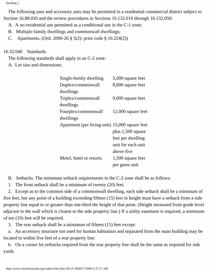
The following uses and accessory uses may be permitted in a residential commercial district subject to Section 16.88.020 and the review procedures in Sections 16.132.010 through 16.132.050: A. A no-residential use permitted as a conditional use in the C-1 zone; B. Multiple-family dwellings and commonwall dwellings; C. Apartments. (Ord. 2000-26 § 5(2): prior code § 10.224(2)) 16.32.040 Standards. The following standards shall apply in an C-2 zone: A. Lot size and dimensions:
Single-family dwelling 5,000 square feetDuplex/commonwall dwellings
8,000 square feet
Triplex/commonwall dwellings
9,000 square feet
Fourplex/commonwall dwellings
12,000 square feet
Apartment (per living unit) 15,000 square feet plus 1,500 square feet per dwelling unit for each unit above five
Motel, hotel or resorts 1,500 square feet per guest unit
B. Setbacks. The minimum setback requirements in the C-2 zone shall be as follows: 1. The front setback shall be a minimum of twenty (20) feet. 2. Except as to the common side of a commonwall dwelling, each side setback shall be a minimum of five feet, but any point of a building exceeding fifteen (15) feet in height must have a setback from a side property line equal to or greater than one-third the height of that point. (Height measured from grade level adjacent to the wall which is closest to the side property line.) If a utility easement is required, a minimum of ten (10) feet will be required. 3. The rear setback shall be a minimum of fifteen (15) feet except: a. An accessory structure not used for human habitation and separated from the main building may be located to within five feet of a rear property line. b. On a corner lot setbacks required from the rear property line shall be the same as required for side yards.
http://www.cityofestacada.org/code/es16tx.htm (28 of 100)8/17/2006 2:37:17 AM
Heading 1
C. No lot area, yard, off-street parking or loading area, or other required open space for one use shall be used as the required lot area, yard, off-street parking or loading area, or other required open spaces for another use. D. Parking Requirements. The number of parking spaces as required in Chapter 16.76 shall apply in the C-2 zone. E. Sidewalks. Sidewalks, driveways and service driveways shall conform to standards established by this code. F. Fences and Walls. A solid fence or wall of not less than six feet in height shall be required along a property line which is the district boundary with an abutting residential district. G. Building Height. No building shall exceed a height of forty-five (45) feet. H. Landscaping. A minimum of five percent of the area developed shall be landscaped. Outdoor storage shall be screened with either a sight-obscuring fence, or a buffer strip of vegetation. (Ord. 2000-26 § 5(3): prior code § 10.224(3)) 16.32.050 Exceptions to standards. The standards of this section pertaining to accessory structures and setbacks may be modified as provided for in Sections 16.60.030 through 16.60.050. (Ord. 2000-26 § 5(4): prior code § 10.224(4)) Chapter 16.36 LIGHT INDUSTRIAL (M-1) Sections:16.36.010 Light industrial zone (M-1).16.36.020 Uses permitted outright.16.36.030 Conditional uses permitted.16.36.040 Standards.16.36.050 Exceptions to standards. 16.36.010 Light industrial zone (M-1). Intended for the expansion of light industrial uses. Permits wholly enclosed light industrial uses and commercial uses which are compatible to the surrounding area. (Ord. 2000-26 § 6 (part): prior code § 10.225 (part)) 16.36.020 Uses permitted outright.
http://www.cityofestacada.org/code/es16tx.htm (29 of 100)8/17/2006 2:37:17 AM
Heading 1
The following uses and their accessory uses are permitted in a M-1 zone: A. Light industry: the manufacturing, processing, compounding, packaging or assembling of products, the process of which does not require or create emissions or discharges other than normal sanitary sewage wastes or the storage of materials which require permits be issued by the Oregon State Department of Environmental Quality; B. A wholly enclosed use involving manufacture, research, repair, assembly, processing, fabricating, packing, distribution, warehousing, wholesaling or storage; provided, that the use does not create a public nuisance or an unreasonable hazard to health or property because of excessive noise, smoke, odor or dust, or because it constitutes a fire, explosion or other physical hazard; C. Agricultural use of land; D. Forestry, including the management, production and harvesting of forest products and of related natural resources in forest areas; E. Owner/manager residence subject to Section 16.60.030(D); F. Public facilities: government uses, offices of governmental agencies and PUD substations. (Ord. 2000-26 § 6(1): prior code §10.225 (1)) 16.36.030 Conditional uses permitted. The following uses and accessory uses may be permitted in a light industrial zone subject to Section 16.88.020 and the review procedures in Sections 16.132.010 through 16.132.050: A. Unenclosed light industrial uses; B. Commercial uses in conjunction with light industrial uses; C. Heavy industrial uses identified under Chapter 16.40; D. Radio, television and/or cellular transmission towers; E. Other commercial use which meet the following requirements: 1. The site and proposed use meet the requirements of Section 16.88.010. 2. The proposed use will not attract traffic which would substantially conflict with industrial traffic or have a substantial adverse effect on other neighboring uses and has adequate access to the highway. 3. The development standards applicable to permitted uses in this zoning district shall apply to conditional uses, except as provided below: a. All on-site lighting shall be designed, located or deflected so as not to shine into off-site structures or impair driving vision. b. All developments shall be subject to site plan review. c. Off-street parking shall be provided as required by Chapter 16.76. (Ord. 2000-26 § 6(2): prior code §10.225 (2)) 16.36.040 Standards. A. Yards. All yards abutting a lot in a residential zone shall be a minimum of twenty (20) feet.
http://www.cityofestacada.org/code/es16tx.htm (30 of 100)8/17/2006 2:37:17 AM

Heading 1
B. Parking Requirements. The number of parking spaces as required in Chapter 16.76 shall apply in the M-1 zone. C. Sidewalks. Sidewalks, driveways and service driveways shall conform to standards established by this code. D. Building Height. No building shall exceed a height of forty-five (45) feet. E. Landscaping. A minimum of five percent of the area developed shall be landscaped. F. Outdoor storage abutting or facing a street, highway or a residential zone shall be screened with a sight-obscuring fence, or a buffer strip of vegetation six feet in height. G. Noise. The applicant shall demonstrate the proposed activity will meet the applicable standards for noise emissions as required by the Oregon State Department of Environmental Quality. (Ord. 2000-26 § 6(3): prior code §10.225 (3)) 16.36.050 Exceptions to standards. The standards of this section pertaining to accessory structures and setbacks may be modified as provided for in Sections 16.60.030 through 16.60.050. (Ord. 2000-26 § 6(4): prior code §10.225 (4)) Chapter 16.40 HEAVY INDUSTRIAL (M-2) Sections:16.40.010 Heavy industrial zone (M-2).16.40.020 Uses permitted outright.16.40.030 Conditional uses permitted.16.40.040 Standards.16.40.045 Exceptions to standards.16.40.050 Auto wrecking yards/junkyards.16.40.060 Extraction and processing of rock, sand, gravel or other earth products or batch plants. 16.40.010 Heavy industrial zone (M-2). Intended for the interest of the public convenience and necessity for outright industrial development in order to more widely advertise the attributes and amenities available in Estacada for industrial uses. (Ord. 2000-26 § 7 (part): prior code §10.226 (part)) 16.40.020 Uses permitted outright.
http://www.cityofestacada.org/code/es16tx.htm (31 of 100)8/17/2006 2:37:17 AM

Heading 1
The following uses and their accessory uses are permitted in a M-2 zone: A. Heavy industry: the manufacturing, processing, compounding, packaging or assembling of products, the process of which requires or creates emissions or discharges other than normal sanitary sewage wastes or the storage of materials which require permits be issued by the Oregon State Department of Environmental Quality; B. A use permitted outright in the M-1 zone; C. Unenclosed light industrial uses. (Ord. 2000-26 § 7(1): prior code §10.226(1)) 16.40.030 Conditional uses permitted. The following uses and accessory uses may be permitted in a heavy industrial zone subject to Section 16.88.020 and the review procedures in Sections 16.132.010 through 16.132.050: A. A use permitted as a conditional use in the M-1 zone if not permitted as an outright use in the M-2 zone; B. Auto wrecking yard or junkyard; C. Extraction and processing of rock, sand, gravel or earth projects or batch plants. (Ord. 2000-26 § 7(2): prior code §10.226(2)) 16.40.040 Standards. The following standards shall apply in a M-2 zone: A. Yards: All yards abutting a lot in a residential zone shall be a minimum of twenty (20) feet. B. Parking Requirements. The number of parking spaces as required in Chapter 16.76 shall apply in the M-2 zone. C. Sidewalks. Sidewalks, driveways and service driveways shall conform to standards established by this code. D. Building Height. No building shall exceed a height of forty-five (45) feet. E. Landscaping. A minimum of five percent of the area developed shall be landscaped. F. Outdoor storage abutting or facing a street, highway or a residential zone shall be screened with a sight-obscuring fence, or a buffer strip of vegetation six feet in height. G. Noise. The applicant shall demonstrate the proposed activity will meet the applicable standards for noise emissions as required by theOregon State Department of Environmental Quality. (Ord. 2000-26 § 7(3): prior code §10.226(3)) 16.40.045 Exceptions to standards. The standards of this section pertaining to accessory structures and setbacks. may be modified as provided for in Sections 16.60.030 through 16.60.050. (Ord. 2000-26 § 7(4): prior code §10.226(4)) 16.40.050 Auto wrecking yards/junkyards.
http://www.cityofestacada.org/code/es16tx.htm (32 of 100)8/17/2006 2:37:17 AM

Heading 1
In addition to meeting the requirements of ORS Chapters 377, 802 and 822, and any other current state law, the following standards shall apply: A. The auto wrecking yard or junkyard shall be fully enclosed by a sight-obscuring fence, free of advertising, maintained in good condition, not less than six feet in height, and of a design approved by the planning commission. B. All automobiles, wrecked or otherwise, shall be kept inside the fenced area at all times, except that vehicles belonging to customers may be parked outside the fence while at the establishment on business. C. All sales, display, storage, repair or other handling of products, merchandise, equipment, and other articles shall occur from within an enclosed building or from within the fenced area. (Ord. 2000-27 § 1: prior code § 10.592) 16.40.060 Extraction and processing of rock, sand, gravel or other earth products or batch plants. A. In addition to meeting the requirements of DOGAMI, Division of Geology and Mineral Resources, DEQ and Clackamas County Health Department, submitted plans and specifications shall contain sufficient information to allow the planning commission to set standards pertaining to the impact to the community. B. Any processing of earth products commonly associated with the excavation of minerals, rocks, sand or gravel, such as the use of crushing, sorting, washing equipment, or batch plants shall be approved using the conditional use procedure. C. Mining equipment and access roads shall be constructed, maintained, and operated in such a manner as to eliminate, as far as is practicable, noise, vibration, or dust which might be injurious or substantially annoying to persons living in the vicinity. (Prior code § 10.596) Chapter 16.44 OPEN SPACE/PUBLIC FACILITIES (O/S) Sections:16.44.010 Purpose.16.44.020 Conditional uses.16.44.030 Standards. 16.44.010 Purpose. This zone is created to ensure public greenways, pathways and parks, to allow governmental uses including public schools and allow them to expand as outright uses, providing it would not substantially increase overall capacity and are consistent with the goals, objectives and policies of the comprehensive
http://www.cityofestacada.org/code/es16tx.htm (33 of 100)8/17/2006 2:37:17 AM

Heading 1
plan. (Prior code § 10.227 (part)) 16.44.020 Conditional uses. Planning commission, after public hearing, may permit the following uses, where such uses are deemed essential or desirable to the public convenience or welfare and are consistent with the goals, objectives and policies of the comprehensive plan. A. Educational institutions; B. Governmental buildings, federal, state and local; C. Public libraries and museums; D. Public utilities, public services and structures; E. Informational and promotional kiosk or centers; F. Public parks. (Prior code § 10.227(1)) 16.44.030 Standards. In the O-S zone, the following standards shall apply. A. Adequate public utilities can be provided. B. Adequate traffic flow and transportation. C. Off-street parking shall be provided as required in Chapter 16.76. D. All yards abutting a lot in a residential zone shall be a minimum of twenty (20) feet. E. Outdoor storage abutting or facing a street, highway or residential zone shall be screened with a sight-obscuring fence, or a buffer strip of vegetation six feet in height. F. Landscaping. At least ten (10) percent of the total area proposed for development shall be set aside for landscaping. G. Adverse Impacts. All impacts including but not limited to the following; noise, traffic, lighting, hours of operations shall be addressed. (Prior code § 10.227(2)) Chapter 16.48 HISTORIC RESOURCES (H-R) Sections:16.48.010 Purpose and intent.16.48.020 Applicability.16.48.030 Historic resource review committee.16.48.040 Uses permitted.16.48.050 Alterations and exterior remodel.
http://www.cityofestacada.org/code/es16tx.htm (34 of 100)8/17/2006 2:37:17 AM

Heading 1
16.48.060 Demolition. 16.48.010 Purpose and intent. The intent and purpose of this overlay district is to implement the goals and policies of the comprehensive plan and encourage property owners to enhance and maintain historically designated resources within the city community. In the H-R zone, the following regulations shall apply. The provisions of this section are intended to: A. Facilitate restoration and upkeep of historic buildings; B. Encourage public knowledge, understanding and appreciation of the city’s history and culture; C. Preserve diverse architectural styles reflecting phases of the city’s history; and encourage complementary design and construction impacting historic resources. (Prior code § 10.228 (part)) 16.48.020 Applicability. A. The provisions of this chapter shall apply to all structures designated as historic resources on the city’s inventory of historic structures. (Prior code § 10.228(A))16.48.030 Historic resource review committee. A. The historic resources review committee shall consist of five members. Until such time as the city council appoints specific members to this committee, the planning commission shall act in this capacity. B. When a specific committee is appointed, members shall serve for three years, except the first term, of which two members shall serve for three years; three members shall serve for two years. C. All demolition and alteration permit requests shall be reviewed by the committee. These permit requests must be reviewed and approved by the historic resource review committee prior to a permit for demolition or alteration being approved. (Prior code 10.228(B)) 16.48.040 Uses permitted. Designated historic resources may be used for any use which is allowed in the underlying district. This includes both primary and conditional uses. For a conditional use to be approved, the proposed use must be found not to be detrimental to the historic resource. (Prior code § 10.228(C)) 16.48.050 Alterations and exterior remodel. A. Maintenance and minor alterations shall not require review by the historic resource review board. Maintenance and minor alterations include: 1. Painting and related preparation of the structure; 2. Repair, replacement and/or change of roofing material; 3. Grounds care and maintenance required for the permitted use of the property; 4. Replacement of fences, shrubs, or other yard fixtures or landscaping; 5. Installation and maintenance of irrigation systems;
http://www.cityofestacada.org/code/es16tx.htm (35 of 100)8/17/2006 2:37:17 AM

Heading 1
6. Addition of gutters and downspouts; 7. Repairing or providing a compatible new foundation that does not result in raising or lowering the building elevation; 8. Change in material to match original type of material on the structure; 9. Placement or replacement of storm windows or doors. B. The historical resource review committee shall review all building permits for additions to existing designated structures and new buildings on the designated site. Review and approval of building permits shall be based on the following criteria: 1. The design of the proposed structure or addition is compatible with the design of the designated structure considering scale, style, height, and architectural detail, materials and colors. C. All applications subject to review shall be accompanied by plans and specifications of the proposed addition or new building. The applicant may be requested to provide additional sketches and other information deemed necessary to allow an informed decision. D. All applications subject to review by the historic resources review committee shall be subject to the notice and hearing standards identified in Chapter 16.132. (Prior code § 10.228(D)) 16.48.060 Demolition. All applications for demolition of a designated historic resource shall be reviewed by the historic resource review committee. The applicant for the demolition permit shall submit the following information: A. A statement identifying the structure’s state of repair (disrepair); B. A statement as to the reasonableness of repairing the structure as opposed to demolition; C. Identification of restoration costs. The historic resource review committee shall review the information submitted by the applicant and make a finding that the structure cannot be reasonably restored or repaired prior to approval. If this finding is satisfied, the demolition permit shall be issued. The review process shall in no case be exercised so as to impose upon any property owner any peculiar or undue hardship, nor to prevent the removal or demolition of any structure which cannot be economically maintained or restored, giving due consideration to all potential uses to which the structure might reasonably be put to use upon restoration by a private property owner. All demolition permits subject to review by the historic resources review committee shall be subject to the notice and hearing procedures identified under Chapter 16.132. (Prior code § 10.228(E))
Chapter 16.52 PLANNED DEVELOPMENT (P-D)*
http://www.cityofestacada.org/code/es16tx.htm (36 of 100)8/17/2006 2:37:17 AM

Heading 1
Sections:16.52.010 Purpose.16.52.020 Review procedures and approval process.16.52.030 Submittal requirements.16.52.040 General requirements.16.52.050 Special considerations. * Prior code history: Prior code § 10.230. 16.52.010 Purpose. A. To permit the application of new technology and greater freedom than may be possible under a strict interpretation of the provisions of this title. B. To facilitate the efficient use of land. C. To promote an economic arrangement of land use, buildings, circulation systems, open space and utilities. D. Encourage a more creative approach in the development of land, and a more efficient, aesthetic and desirable use of common open space areas. E. Allow flexibility in design, placement of buildings, use of open spaces, circulation facilities, off-street parking areas for sites with natural features such as streams and wetland and other physical characteristics including geography, topography, size and shape. F. Provide flexibility to allow for the transfer and mixture of densities between zoning districts in order to provide better housing and transportation options that can be achieved through conventional development practices. G. Improve the protection of open spaces, wetlands, riparian corridors and other natural features. (Ord. 2005-6 § 1 (part))16.52.020 Review procedures and approval process. A. There are three steps required for a planned development approval: 1. Approval of an overlay zone and concept plan; 2. Approval of a detailed development plan and/or preliminary subdivision plat; 3. Approval of a final subdivision plat(s), and building permits in accordance with the detailed development plan. B. An application for an overlay zone/concept plan and development plan and/or preliminary subdivision plat may be heard concurrently. C. Within two years after the date of final approval of an overlay zone and concept plan, a detailed development plan and/or preliminary subdivision plan shall be filed with the city. D. Planned developments shall be subject to all the requirements of the underlying zoning districts in which the development is located, applicable zoning regulations in Division III and land division standards
http://www.cityofestacada.org/code/es16tx.htm (37 of 100)8/17/2006 2:37:17 AM

Heading 1
in Division IV of this title except as modified through this review procedure. E. Planned developments shall be reviewed by the planning commission and city council pursuant to Chapter 16.132 of the city code. The planning commission shall recommend denial, approval or approval with conditions to the city council. The city council shall conduct a public hearing and render a final decision on the application. F. Approval may be made subject to such conditions the city finds necessary to carry out the purposes of this chapter. These conditions may include, but are not limited to, the following: 1. Increasing the required setbacks; 2. Limiting height of buildings; 3. Controlling location and number of vehicular access points; 4. Establishing new streets, increasing right-of-way or roadway widths or existing streets, requiring curbs and sidewalks, and, in general, improving traffic circulation systems; 5. Increasing number of parking spaces and improving design standards for parking areas; 6. Limiting number, size, location and lighting of signs; 7. Designating additional sites for open space and recreational development, and, in general, improving proposed landscaping; 8. Requiring additional view-obscuring screening or fencing; 9. Requiring a performance agreement to assure that the planned development is completed as approved within the time limit as established by this section. G. Building permits for all or any portion of a planned development shall be issued on the basis of the approved plan. An application for a building permit shall be preceded or accompanied by submission of any required performance agreements, deeds for public dedication or contractual agreements for developments of public facilities and services. H. A planned development approval shall be valid for five years after the date of the final decision on the detailed development plan or tentative land division. The city may approve a time schedule for developing the site in phases not to exceed ten (10) years. If no building permits have been issued within five years from the date of adoption of the P-D overlay zone, it shall be terminated and the overlay zone shall automatically be repealed, unless a request to extend the time limit is approved by the planning commission. Time extensions shall be subject to Section 16.108.050 of this title. (Ord. 2005-6 § 1 (part)) 16.52.030 Submittal requirements. A. General Application Requirements. An application for a P-D overlay zone/concept plan shall include: 1. A statement of the planning objectives to be achieved by the planned development. The statement shall include a description of the character of the proposed development and the reasoning to support the design and any modifications of the city code related to proposed land uses, building types and densities, setbacks, open spaces, streets, etc.;
http://www.cityofestacada.org/code/es16tx.htm (38 of 100)8/17/2006 2:37:17 AM

Heading 1
2. A development schedule indicating any phasing proposals and approximate dates when construction of the planned development is expected to be initiated and completed; 3. Maps and supporting narrative identifying the following: a. Existing site conditions, b. A site concept plan, c. A grading concept plan, d. A landscape concept plan, e. A sign concept plan; 4. A copy of any proposed restrictions or covenants. B. Development Review Application Requirements. An application for a detailed development plan or land division shall include the following: 1. A tentative plan including all the information listed in Section 16.120.020(B) of this title; 2. A specific list and description of standards proposed to be modified; 3. Other technical information necessary to address the standards of this section and other applicable requirements of the city code. This may include traffic impact studies, environmental studies, geologic or engineering studies and sewer, water and surface water studies; 4. Any other information necessary to determine compliance with the proposed or approved concept plan. (Ord. 2005-6 § 1 (part)) 16.52.040 General requirements. A. A P-D zone may be established in combination with any other zone. B. Planned developments may be established in single-family residential, multifamily residential, commercial, industrial and open space districts. C. A P-D zone may contain only a planned development that has been approved in accordance with the provisions of this chapter. D. A P-D zone shall not be less than five acres. E. A planned development may include any uses permitted outright or conditionally in any zone with the following exceptions: 1. Residential uses shall not be permitted in an M-1 or an M-2 zone; 2. Uses permitted only in an M-1 or M-2 zone shall not be permitted in any other zone. F. The following uses also may be allowed, when developed in conjunction with a primary use: 1. Recreational facilities including, but not limited to, tennis courts, swimming pools and playgrounds; 2. Open space uses including, but not limited to, nature trails, bird sanctuaries and nature conservatories. G. Requirements pertaining to density shall be based on the standards of the zone in which the property is located. Other standards of the zone may be modified as they apply to streets, lot size, lot coverage, setbacks and landscaping.
http://www.cityofestacada.org/code/es16tx.htm (39 of 100)8/17/2006 2:37:17 AM

Heading 1
H. No building shall exceed a height that is fifty (50) percent greater than that of the maximum building height limitation of the zone in which the planned development is proposed. Such height increases may be approved by the planning commission, provided the proposed height is not detrimental, incompatible or otherwise undesirable with respect to existing or future area development, and provided that one of the following two situations is determined to exist: 1. That the height increase can be justified on the basis of unique lot characteristics, topographical conditions or other natural features; or 2. That the height increase can be justified on the basis of amenities provided or concessions made by the developer for which some bonus incentive is warranted. I. Open Space. At least twenty (20) percent of the land area will be dedicated or reserved as common open space land in residential, recreational or combination residential-commercial developments. 1. Open space may include bicycle or pedestrian trails, natural or landscaped buffer areas, covered bus stops, significant natural vegetation or landscape, and community recreation facilities such as tennis courts, recreation buildings or swimming pools. 2. Open space shall not include parking areas, except those areas in conjunction with recreation facilities, or roadways. 3. Filling or placement of debris within the open space area is prohibited, unless specifically authorized by the city. 4. Private vehicle access easements serving the neighboring properties are prohibited within the open space area. 5. Developments shall be designed so that no dwelling unit is located more than one thousand (1,000) feet from an open space area. 6. Individual open space areas should be large enough to be usable; as a guideline, a minimum of five thousand (5,000) square feet is suggested. 7. All improvements associated with the open space, such as recreation centers, swimming pools and tennis courts shall be constructed or a guarantee shall be posted per Section 16.116.050 of this title. J. All utilities, electric and telephone facilities, fire alarm conduits, street light wiring and other wiring, conduits and similar facilities shall be placed underground unless waived by the city. K. The city may require easements necessary for orderly extension of public utilities to future adjacent developments. L. Lands and structures not dedicated to the public but reserved for use by owners or tenants and their guests must be subject to an association of owners or tenants created to form a nonprofit corporation under the laws of the state of Oregon. This association shall be formed and continued for the purpose of maintaining such common areas and structures. (Ord. 2005-6 § 1 (part)) 16.52.050 Special considerations. A. Before approval of a P-D overlay zone application, the planning commission shall determine that:
http://www.cityofestacada.org/code/es16tx.htm (40 of 100)8/17/2006 2:37:17 AM

Heading 1
1. The development will be consistent with the comprehensive plan provisions and zoning objectives of the area; 2. The development will be compatible with adjacent and nearby land uses and accommodate planned and necessary transportation and utility services and facilities to serve the area. For purposes of this evaluation, the lands at least two hundred fifty (250) feet from the outside boundary of the lot upon which the development is proposed shall be considered; 3. The streets are adequate to support the anticipated traffic and the development will not overload the streets outside the planned development area; 4. Proposed utility and drainage facilities are adequate for the population densities and type of development proposed and will not create a drainage or pollution problem outside the planned area. B. In considering a proposed planned unit development, all requirements of the city code shall apply, except as modified below: 1. Site Adaptation. To the maximum extent possible, the plan and design of the development shall assure that natural or unique features of the land are preserved. 2. Lot Arrangement. All lots within the development shall have reasonable access to open space or recreation areas. 3. Density of Development. For purposes of determining residential density, computations involving residential land shall be subject to the underlying zoning district. 4. Individual lot size is unrestricted, provided that the overall density of the development shall not exceed the density in the underlying zoning district. 5. Community Services. The city may request the dedication of proposed open space land that is reasonably suited for use as a city park or for recreation purposes, taking into consideration such factors as size, shape, topography, geology, access, location, and applicable comprehensive plan policies, when such dedication is consistent with the ability of the city to maintain such parks. 6. Structure Setback Provision. a. Yard setbacks for lots on the perimeter of the plat area shall be the same as that required for the underlying zoning district. b. Minimum front yard setback is twenty (20) feet. This standard may be modified for residential dwellings, providing any garage structure facing a street maintains a twenty (20) foot setback. c. All detached structures shall maintain a minimum side yard setback of three feet or meet the Uniform Building Code requirement for firewalls. d. Minimum rear yard setback is three feet for all detached and attached structures or meets the Uniform Building Code requirement for firewalls. 7. Individual Lot Street Frontage. No individual lot street frontage is required when such lots are shown to have adequate access in a manner that is consistent with the purposes and objectives of this section. 8. Parking Standards.
http://www.cityofestacada.org/code/es16tx.htm (41 of 100)8/17/2006 2:37:17 AM
Heading 1
a. Two off-street parking spaces per dwelling unit shall be established. b. Off-street parking may be provided on each lot or in parking areas in proximity to the dwelling units they serve. c. Guest parking may be required after consideration of street type, width, traffic, volume, transit amenities and pedestrian circulation. d. Sufficient parking space may be required for storage of residents’ recreational vehicles. If required, recreational vehicle parking shall be located so as to be compatible with the surrounding development. If located on the perimeter of the development, it shall be screened from adjacent properties. 9. Homeowners’ Association. A nonprofit incorporated homeowners’ association, or an alternative acceptable to the city, shall be required if other satisfactory arrangements have not been made for improving, operating and maintaining common facilities, including open space, streets, drives, service and parking areas, recreation areas, and for snow removal and storage. The following principles shall be observed in the formation of any homes association and shall be reviewed by the city attorney’s office. a. A homeowners’ association shall be established prior to approval and recording of the final plat, or any portion thereof. b. Membership shall be mandatory for each homebuyer and any successive buyer. c. The open space restrictions shall continue in perpetuity. d. The homeowners’ association shall be responsible for liability insurance, local taxes, and the maintenance of recreational and other facilities. e. Homeowners shall pay their pro rata share of the cost or the assessment levied by the association shall become a lien on the property. f. The homeowners’ association shall be able to adjust the assessment to meet changes needed. g. No change in open space use or dissolution of the homeowners’ association shall occur without a public hearing before the city council. 10. An alternative to a homeowners’ association may include deed restrictions or conservation easements, when the city determines such will protect the intent and purposes of this chapter and be in the public’s interest. (Ord. 2005-6 § 1 (part)) Chapter 16.56 WETLANDS OVERLAY (W/O) Sections:16.56.010 Purpose.16.56.020 Designation of wetland areas.
http://www.cityofestacada.org/code/es16tx.htm (42 of 100)8/17/2006 2:37:17 AM

Heading 1
16.56.010 Purpose. The intent and purpose of this overlay is to implement the goals and policies of the comprehensive plan and protect the designated wetland resources within the community. (Prior code § 10.231 (part)) 16.56.020 Designation of wetland areas. Wetland areas within the Estacada urban growth boundary are identified on inventory maps prepared by the U.S. Department of the Interior, Fish and Wildlife Service. Pursuant to OAR 660-16-000(5)(b), the city shall designate the wetlands and riparian habitat areas identified on the National Wetlands Inventory (NWI) as potential resource sites and rely on state and federal permits for proposed development on the sites. (Prior code § 10.231 (part)) Division III. Zoning Regulations Chapter 16.60 SUPPLEMENTARY REGULATIONS Sections:16.60.010 Clear vision areas.16.60.020 Exterior lighting.16.60.030 Accessory structures/uses.16.60.040 Projections from buildings.16.60.050 General exceptions to yard requirements.16.60.060 Bed and breakfast inns. 16.60.010 Clear vision areas. A clear vision area shall be maintained on the corners of all property at the intersection of two streets or from the intersection of a private road easement and a public street. A. A clear vision area shall consist of a triangular area, two sides of which are lot lines measured from the corner intersection of the street lines or corner intersection of a private road easement, for a distance specified in this regulation, or, where the lot lines have rounded corners, the lot lines extended in a straight line to a point of intersection so measured, and the third side of which is a line across the corner of the lot joining the nonintersecting end of the other two sides. B. A clear vision area shall contain no planting, fence, wall, structure or temporary or permanent obstruction exceeding 2.5 feet or thirty (30) inches in height measured from the top of the curb, or, where no curb exists, from the established street center line grade, except that trees exceeding this height may be
http://www.cityofestacada.org/code/es16tx.htm (43 of 100)8/17/2006 2:37:17 AM

Heading 1
located in this area; provided, that all branches and foliage are removed to a height of eight feet above grade. In all zones the minimum distance shall be fifteen (15) feet, or at intersections including an alley, ten (10) feet. (Prior code § 10.234) 16.60.020 Exterior lighting. Exterior lighting for uses in commercial and industrial zones shall be located in such a manner so as not to face or shine directly onto a lot in a residential zone, street or highway. (Prior code § 10.455) 16.60.030 Accessory structures/uses. An accessory use shall comply with all requirements for a principal use, except as this title specifically allows to the contrary, and shall comply with the following limitations: A. Accessory Structures. An accessory structure not used for human habitation and separated from the main building may be located to within five feet of a rear property line if the structure is no more than fifteen (15) feet in height. Structures over fifteen (15) feet must meet the setback standards established in each zoning district. B. Fences. Fences, hedges and walls limited to six feet in height may be located within required yards, but shall not exceed two and one-half feet or thirty (30) inches in height in any required yard setback which abuts corner property at the intersection of two streets, or from the intersection of a private drive or road easement and a public street or alley. C. Decks. Unenclosed decks, unroofed landings, porches and stairs may project into any required yard providing the following conditions are met: 1. No portion except for guard rails shall extend above the floor level of a habitable room. 2. No such projection shall obstruct a stairway. 3. No such projection shall extend into a required yard no more than one-third the distance of the required setback. D. Manager/Caretaker Residences. In the M-1 and M-2 zones, a residence may be established secondary to the main use of the property for the sole purpose of providing living quarters for the owner, operator or caretaker of a commercial or industrial enterprise; provided that: 1. The living space shall be located on the same property as the commercial or industrial operation and is justified by the requirement of twenty-four (24) hour attendance; 2. Occupancy is limited to the manager/caretaker and their immediate family. E. R.V. Conversions. Recreational vehicles cannot be utilized for a commercial business on a permanent basis. Temporary placement may be authorized by the planning commission using the procedure for conditional uses as set forth in Chapter 16.88. (Prior code § 10.460) 16.60.040 Projections from buildings.
http://www.cityofestacada.org/code/es16tx.htm (44 of 100)8/17/2006 2:37:17 AM

Heading 1
Architectural features such as cornices, eaves, canopies, sunshades, gutters, signs, chimneys and flues shall not project more than eighteen (18) inches into a required yard. (Prior code § 10.500) 16.60.050 General exceptions to yard requirements. The following exceptions to the front yard requirement for any structure are authorized for a lot in any zone. A. The required front or rear yard for a structure may be based upon the average of the front or rear yards of dwellings/garages on all lots within one hundred (100) feet of both sides of the proposed structure. On vacant parcels within one hundred (100) feet, standard lot requirements shall be used in establishing the average. B. Special Setback Requirements. Under certain circumstances the following special set-back requirements shall apply: 1. Buildings and pens, which are part of kennels and animal hospitals, and active recreation use areas which are a part of outdoor commercial amusement or recreation establishments shall be located no closer than seventy-five (75) feet from a residential zone. 2. Clubs, lodges, fraternal organizations, community swimming pools, and buildings housing recreational facilities in residential zones shall be located no closer than thirty (30) feet from any other lot in a residential zone. (Prior code § 10.520) 16.60.060 Bed and breakfast inns. A. Operator. All bed and breakfast inns shall be managed by a resident of the dwelling. B. Structural Type. Bed and breakfast inns shall be restricted to single-family residences, guest houses and historic landmark buildings. C. Structural Appearance. The exterior of the building must maintain a residential appearance if located in a residential zone. D. Signs. Only one on premise ground or wall nonilluminated wood sign of six square feet maximum size shall be allowed if the bed and breakfast inn is located in a residential zone. E. Service. Breakfast shall be the only meal served to inn guests. F. Licensing. Bed and breakfast inns renting out more than two sleeping rooms for guests must be licensed by the county health department. G. Length of Stay/Guest Register. The duration of each guest’s stay shall be limited to no more than sixty (60) days in any one-year period. An accurate, up-to-date guest register must be maintained and available for review by any authorized agent of the city, county or state. H. Number of Guest Rooms Allowed. No more than five sleeping rooms shall be available for the accommodation of inn visitors. I. Parking Requirements. One off-street parking space shall be provided for owners/operators with one additional space for each authorized guest room. Off-street parking shall be provided in accordance with
http://www.cityofestacada.org/code/es16tx.htm (45 of 100)8/17/2006 2:37:17 AM

Heading 1
standards set forth in Chapter 16.76. (Prior code § 10.598) Chapter 16.64 ADULT BUSINESSES Sections:16.64.010 Intent, purpose and findings.16.64.020 Definitions.16.64.030 Spatial separation requirements.16.64.040 Adult entertainment business license. 16.64.010 Intent, purpose and findings. The city council intends by the adoption of this chapter to ameliorate adverse impacts on schools and school children caused by the location of adult entertainment businesses, as defined herein, in close proximity to school aged children, by means of reasonable regulation of the time, place and manner of such businesses, without suppression of legitimate forms of communications offered, or the right of adult entertainment businesses to have access to such legitimate forms of communication. (Prior code § 10.219(1)) 16.64.020 Definitions. As used in this chapter: “Adult entertainment business” is a term intended to cover a broad range of activities characterized by exhibitions of live, closed circuit, or reproduced material which has an emphasis on nudity and/or sexual activity. The term “adult business” also includes the full range of adult theaters and related businesses defined below. Adult businesses generally limit their patrons to persons at least eighteen (18) years of age. Adult businesses include the following types of establishments: adult bookstores, adult theaters, adult arcades, adult cabarets, adult paraphernalia shops, and other establishments which feature a combination of activities or merchandise described above which collectively make up a substantial or significant portion of the establishment’s activities or merchandise. The term “adult entertainment business” also includes other uses similar to the uses listed above, presenting material for patrons to view (live, closed circuit or reproductions), and/or purchase or rent, a substantial portion of which is characterized by an emphasis on nudity and/or specific sexual activity; and limiting entrance to patrons who are over eighteen (18) years of age. “Adult bookstore” means an establishment having, as substantial or significant portion of its merchandise, such items as books, magazines, other publications, films, video tapes, or video discs, which
http://www.cityofestacada.org/code/es16tx.htm (46 of 100)8/17/2006 2:37:17 AM

Heading 1
are for sale, rent, or viewing on premises and which are distinguished by their emphasis on matters depicting specified sexual activities. “Adult theater” is an establishment used primarily for presenting material (either live, closed circuit, or pre-recorded) for observation by patrons therein, having as a dominant theme an emphasis on nudity and/or specified sexual activities. “Adult arcade” is an establishment offering viewing booths or rooms for one or more persons in which a substantial portion of the material presented (either live, closed circuit, or reproduced) is characterized by an emphasis on nudity and/or specified sexual activities. “Adult cabaret” is an establishment having as its primary attraction live exhibition (either for direct viewing, closed circuit viewing, or viewing through a transparent partition) for patrons, either individually or in groups, where a substantial portion of the material presented is characterized by an emphasis on nudity and/or specified sexual activities. “Adult paraphernalia shop” is an establishment offering as a substantial or significant portion of its merchandise, objects which simulate human genitalia and/or objects designed to be used to substitute for or be used with human genitalia while engaged in specified sexual activities. “Nudity” or “nude” means being devoid of a covering for the male or female genitalia consisting of an opaque material which does not simulate the organ covered and in the case of a female exposing to view one or both breasts without a circular covering, centered on the nipple that is at least three inches in diameter and does not simulate the organ covered. “Specified sexual activities” means real or simulated acts of human sexual intercourse, human/animal sexual intercourse, mastur-bation, sadomasochistic abuse, sodomy or the exhibition of human sexual organs in a stimulated state or the characterization thereof in printed form. (Prior code § 10.219(2)) 16.64.030 Spatial separation requirements. A. No adult entertainment business shall be located within a distance closer than five hundred (500) feet from a public or private kindergarten, elementary, junior high, high school, college or university, unless an adult entertainment license is first issued by the city for the business. B. The distance referred to herein shall be measured in a straight line, without regard to intervening streets, structures, or obstructions, from the closest point of the structure or portion of the structure housing the adult business establishment, or the closest point of the parking lot or portion of the parking lot principally used by the patrons of the business containing the adult entertainment business, to the closest point of the school property or school use. (Prior code § 10.219(4)) 16.64.040 Adult entertainment business license. Before an adult entertainment business license is issued, the city council shall hold a public hearing on the application. The application will be issued, unless the city council determines that it is highly likely that one or more of the deleterious effects of adult business establishments set forth in Section 16.64.010
http://www.cityofestacada.org/code/es16tx.htm (47 of 100)8/17/2006 2:37:17 AM

Heading 1
would occur if the proposed adult business is located at the proposed site described in the application. The city council in making this determination may base its finding on historical data from other municipalities or from the past business activities of the applicant at other locations. The public hearing will be conducted within thirty (30) days of the date of the application for adult entertainment business license is filed with the city. (Prior code § 10.219(5)) Chapter 16.68 NATURAL HAZARD AREAS Sections:16.68.010 Purpose.16.68.020 Scope.16.68.030 Natural hazard areas. 16.68.010 Purpose. The intent of development guidelines is to provide procedures necessary to secure the desirable attributes of the city from depletion, and to protect against hazardous or otherwise undesirable development activities. (Prior code § 10.700) 16.68.020 Scope. Development guidelines shall apply to those areas of concern delineated on the city comprehensive plan map and plan inventories or any area determined potentially hazardous by the planning commission and shall also apply to any property that has a slope of thirty-three (33) percent or greater as defined by a (3:1) ratio, 3 horizontal: 1 vertical. (Prior code § 10.702) 16.68.030 Natural hazard areas. The following development guidelines are applicable to hazards identified above and in the State Department of Geology and Mineral Industries, Bulletin 78, Environmental Hazard Inventory, Clackamas County, Oregon. The above documents and mapping are referenced and adopted as part of the comprehensive plan and available in the office of the city recorder. A. Purpose. Various geological formations in the city have different characteristics with respect to suitability for development because of landslide potential, high groundwater, and soil characteristics. The following development guidelines have been prepared in order that geological hazards will be recognized and the losses resulting therefrom will be lessened. B. Areas of Concern. The primary areas of concern are active and potential landslides, high
http://www.cityofestacada.org/code/es16tx.htm (48 of 100)8/17/2006 2:37:17 AM

Heading 1
groundwater, weak foundation soils, and steep slopes. C. Considerations. The most important consideration with respect to natural hazard factors are: 1. That development approved is not hazardous to buildings, structures or the inhabitants thereof; 2. That protection to unsuspecting purchasers of property having natural hazards is provided; 3. That unjustified expenditure of public funds or losses incurred due to natural hazards resulting in damage to development which should not have been approved initially, is prevented. D. Standards. The following shall be required in hazard areas as identified: 1. Geologically recent landslide areas: a site specified geotechnical analysis by a qualified professional geologist or engineering geologist including all property outside of known or suspected hazard that is within one hundred (100) feet. 2. Weak Foundation Soils. In areas known to have weak foundation soils for construction of buildings and roads, a detailed soils analysis shall be made by a qualified soils expert. The analysis shall include a recommendation to overcome identified limitations prior to development approval. 3. Slopes Greater than Thirty-Three (33) Percent. A site specified geotechnical analysis by a qualified professional geologist or engineering geologist will be required. E. Procedure. When a geotechnical analysis or soils analysis is required, the following procedure shall be followed in determining the suitability and desirability of development proposed in areas having geological hazards: 1. Requesters of development approval within hazard areas shall be required to submit a statement as to how such hazards have been recognized in the proposal. Such statement shall be required to include the following: a. The cause, the extent and the potential of the hazards; b. The provisions proposed to overcome the hazards; c. A certified declaration as to the on-going responsibility of the developer should such hazards be of a nature whereby possible future danger may exist. Such declaration should include the developer’s intent to continue or absolve responsibility should the development be sold; d. Additional material as determined to be desirable to make a determination as to the acceptability of the statement; e. The name and professional stamp of that person or persons determining the causes, extent and potential of the hazards as well as the provisions proposed to overcome the hazards. (Prior code § 10.705) Chapter 16.72 SIGNS Sections:
http://www.cityofestacada.org/code/es16tx.htm (49 of 100)8/17/2006 2:37:17 AM
Heading 1
16.72.010 Purpose.16.72.020 Definitions.16.72.030 General regulations.16.72.040 Signs in residential zones--R-1, R-2 and R-3 zones.16.72.050 Signs in commercial and industrial zones.16.72.060 Nonconforming signs.16.72.070 Banner signs. 16.72.010 Purpose. The purpose of this chapter is to provide a safe, consistent, equitable and legal system of signing. The regulations of such factors as size, location, construction, etc., will encourage the communication of information and orientation for both visitors and citizens; provide for the effective identification and advertisement of business establishments; eliminate visual blight; and provide standards to safeguard life, health, property and public welfare. (Prior code § 10.235 (part)) 16.72.020 Definitions. As used in this chapter, the following words and terms shall have the meanings ascribed to them in this section: “Billboard” means a sign or structure subject to the provisions of the Oregon Motorist Information Act of 1971 and erected for the purpose of leasing advertising space to promote an interest other than that of an individual, business, product or service available on the premises the billboard is located on. “Building frontage” means the linear frontage of a building measured along a street or alley between two lines projecting perpendicular from the street to the corners of the building. “Canopy” means a structure made of cloth, metal or other material with frames affixed to the building. “Construction sign” means any information sign which identifies the architect, engineers, contractors, and other individuals or firms involved with the construction of a building, or announcing the character of the building or enterprise, which is erected during the building construction period. “Directional sign” means a single panel in a size, type and height determined and approved by the public works director and containing information regarding location of specific municipal or nonprofit organizations. Directional signs shall be installed by the public works department and located on existing street sign posts. “Electronic changing sign” means an electronic sign upon which the entire copy or message may appear or change from time to time upon a lamp bank, such as time and temperature displays, which by its nature and intensity is not a flashing sign. “Flashing sign” means any sign which contains or is illuminated by a light source which produces a brilliant flash and darkness on an alternating basis, which results in a pulsating effect designed primarily to attract attention.
http://www.cityofestacada.org/code/es16tx.htm (50 of 100)8/17/2006 2:37:17 AM

Heading 1
“Free-standing sign” means any sign set apart with no structural attachments to a building structure and is meant to include ground-mounted or pole signs for the purpose of these regulations. “Grade” means the relative finished ground level within twenty (20) feet of the sign. “Ground sign” means a sign which is mounted on the ground and supported by one or more uprights, poles or braces in or upon the ground other than a pole sign as defined. The bottom of such signs shall be no higher than three feet, and they shall extend no higher than eight feet. “Height or height of sign” means the vertical distance from the average grade within twenty (20) feet of the structure to the highest point of a sign or any vertical projection thereof, including its supporting columns. “Incidental sign” means small signs, less than two square feet in surface area, of a noncommercial nature, intended primarily for the convenience of the public. Included are signs designating restrooms, address numbers, hours of operation, entrances to buildings, directions, help wanted, public telephone, etc. Also included in this group of signs are those designed to guide or vehicular traffic to an area or place on the premises of a business, building or development by means of a directory designating names and addresses only. “Lighting, indirect or internal” means any illuminated sign constructed so that the immediate source of illumination is visible when the sign is lighted and which does exceed ten (10) candle power per square foot measured at ten (10) feet from the sign. “Moving sign” means any sign which produces apparent motion of the visual image, including, but not limited to, illusion of moving objects, moving patterns or bands of light, expanding or contracting shapes, rotation or any similar effect of animation which is designed or operated in a manner primarily to attract attention. “Pole sign” means a single or multiple-faced sign eight or more feet above grade, supported by one or more uprights in the ground and detached from any building or structure. “Political sign” means a sign advertising a candidate or candidates for public elective office, or a political party, or a sign urging a particular vote on a public issue decided by ballot. “Portable sign” means any sign not meeting the anchorage requirements of the Uniform Sign Code. “Projecting sign” means a single or multiple-faced sign which is designed and constructed to be mounted to the wall of a building and which will extend more than twelve (12) inches from the wall. “Property line” means the line denoting the limits of legal ownership of property. “Readerboard” means a sign or part of a sign on which the letters are readily replaceable such that the copy can be changed from time to time at will. “Roof sign” means any sign erected upon, against, or directly above a roof or on top of or above the parapet of a building, including a sign affixed to any equipment attached to the building. “Sandwich (A) board” means a double-faced sign hinged or connected at the top which is spread for stabilization and set upon the ground. “Sign” means any medium, including its structure and component parts, other than paint on a building,
http://www.cityofestacada.org/code/es16tx.htm (51 of 100)8/17/2006 2:37:17 AM

Heading 1
which is used or intended to be used to attract attention to the subject matter for communication purposes. “Sign area” means the surface contained within a single continuous perimeter which encloses the entire sign cabinet but excluding any support of framing structure that does not convey a message. Where signs are of a three-dimensional, round, or other solid shape, the largest cross-section viewed as a flat projection shall be used for the purpose of determining the sign area. Signs visible from more than one direction or without clearly defined sign faces shall be considered as having two faces and each face calculated in the total allowable area. “Street frontage” means street(s), alley(s), or public right(s)-of-way parallel to the property line used to compute the area of sign(s) intended to be located in such a manner as to have primary exposure on that street or right-of-way. “Temporary sign” means any sign, banner, pendant, valance, or advertising display constructed of cloth, canvas, light fabric, cardboard, wallboard, or other light material intended to be displayed for a period of less than ten (10) days in any calendar year. “Vision clearance area” means a triangular area on a lot at the intersection of two public rights-of-way, a street and a railroad, or point of vehicular access and a public right-of-way, two sides of which are lines measured from the corner intersection to a distance of twenty (20) feet. The third side of a triangle is a line across the corner of the lot connecting the lines of the other two sides. The vision clearance area contains no signs higher than three feet or lower than eight feet measured from the grade of the street centerline, though a single pole having a diameter of eighteen (18) inches or less is permitted. “Wall sign” means a single-face sign which does not extend more than twelve (12) inches from the wall and the copy of which runs parallel to the wall to which it is attached. “Window sign” means a sign which is applied to, attached to, or located within the interior of a window. (Prior code § 10.235(1))16.72.030 General regulations. A. No sign governed by the provisions of this chapter shall be erected, structurally altered or relocated without first receiving a sign permit from the city. B. All signs shall comply with the following requirements and those specified by zoning district: 1. Construction shall satisfy the requirements of current version of the Uniform Sign Code. 2. Electrical requirements for signs shall be governed by the current version of the National Electrical Code and Oregon Electrical Specialty Code Amendments. 3. Except for exempt signs, all signs shall be securely attached to a building or the ground. 4. All signs, including exempt signs, shall conform to all vision clearance requirements. 5. All signs, including exempt signs, together with their supports, braces, and guys shall be maintained in a safe and secure manner. 6. All illuminated signs shall be internally or indirectly illuminated. C. The following signs shall be exempt from the application, permit and fee requirements of this title. 1. Impermanent construction and subdivision signs not exceeding thirty-two (32) square feet in area;
http://www.cityofestacada.org/code/es16tx.htm (52 of 100)8/17/2006 2:37:17 AM

Heading 1
2. Directional, warning or information signs or structures required or authorized by law, or by federal, state, county or city authority; 3. Historical site plaques; 4. Official and legal notices issued by any court, public body, person or officer in performance of a public duty or in giving any legal notice; 5. Official flags of the United States of America, counties, municipalities, official flags of foreign nations, and flags of internationally and nationally recognized organizations; 6. On-premise signs not readable from the public right-of-way, i.e., menu boards, etc.; 7. Political signs, provided such signs shall not exceed four square feet in area in residential or commercial/industrial zones respectively or be posted more than forty-five (45) days before the election to which they relate and are removed within fifteen (15) days following the election; 8. Real estate signs not exceeding four square feet in area in residential districts or thirty-two (32) square feet in commercial or industrial districts; 9. Residential identification signs not exceeding two square feet; 10. Structures intended for a separate use such as phone booths, Goodwill containers, etc.; 11. Temporary signs not exceeding four square feet; 12. Window signs. D. The following signs are prohibited: 1. Flashing and moving signs; 2. Portable signs; 3. Sandwich (“A”) boards; 4. Signs attached to utility, streetlights, or traffic control standard poles or otherwise located in the public right-of-way without a permit; 5. Signs in a dilapidated or hazardous condition; 6. Signs on doors, windows, or fire escapes that restrict free ingress or egress; 7. Signs which purport to be, are an imitation of, or resemble an official traffic sign or signal, could cause confusion with any official sign, or which obstruct the visibility of any traffic sign or signal; 8. Swinging signs; 9. Billboards. E. All free-standing signs shall comply with the following provisions: 1. One free-standing sign shall be permitted along each street frontage, or each three hundred (300) feet of street front, with one additional free-standing sign allowed on the property. 2. A free-standing sign shall be placed behind the property line and no closer than ten (10) feet to any adjacent private property line. 3. Free-standing signs may project over the public property line, provided they conform to the standards established for projecting signs. F. All projecting signs shall comply with the following provisions:
http://www.cityofestacada.org/code/es16tx.htm (53 of 100)8/17/2006 2:37:17 AM

Heading 1
1. No projecting sign shall extend above the highest structural component of the building to which it is attached. 2. Signs over the public right-of-way, including free-standing signs, shall conform to the following standards: Clearance Maximum ProjectionLess than 8’ Not permitted8’ 1’9’ and above 2 feet for every foot above 8
feet in height but no more than 9 feet
No sign shall project within two feet of the curb line. G. All roof signs shall comply with the following provisions: 1. All roof signs shall be installed or erected in such a manner that no support structure is visible from any abutting public right-of-way. 2. Roof signs may be erected so as to appear from all sides as a wall sign applied to an existing penthouse which appears to be a part of the building itself. 3. Roof signs shall not exceed the highest point of the building or structure. On flat roofs, the roof sign shall not exceed eight feet above the highest point of the building. In no case shall a sign exceed the maximum allowable height of the building within the zone in which it is located. H. All wall signs shall conform to the following provisions: 1. Wall signs may be attached flat to, or pinned away from the wall, but shall not project more than twelve (12) inches from the wall. 2. Wall signs shall not extend above the height of the wall to which it is attached. I. Any sign which is not in compliance is an unlawful sign and declared to be a public nuisance. 1. The city may order the removal of any sign erected or maintained in violation of this chapter. It shall give twenty-four (24) hours’ notice in writing to the owner of such sign, or of the building structure, or premises on which the sign is located, to remove the sign or bring it into compliance. 2. The city may remove a sign immediately and without notice if, in its opinion, the condition of the sign is such as to present an immediate threat to the safety of the public, and is authorized to take such steps as may be necessary to remove the sign. Neither the city or any of its agents shall be liable for any damage to the sign. 3. The violation of or failure to comply with any of the provisions of this chapter or the erection, use or display or the allowing of, the permitting of, or the suffering erection, use or display of any sign not in compliance with all the provisions of this title. 4. The remedies provided in this chapter for violations of or failure to comply with provisions of this
http://www.cityofestacada.org/code/es16tx.htm (54 of 100)8/17/2006 2:37:17 AM

Heading 1
ordinance shall be cumulative and shall be in addition to any other remedy provided by law. (Prior code § 10.235(2)) 16.72.040 Signs in residential zones--R-1, R-2 and R-3 zones. A. One name plate or identification sign with a maximum of two faces not exceeding two square feet per face per dwelling unit is permitted. Uses allowed conditionally may be allowed to erect one sign per street frontage not to exceed thirty-two (32) square feet. B. Signs permitted outright in the R-1, R-2 and R-3 zones may be located anywhere on the premises; however, no free-standing sign may exceed eight feet in height or project beyond any property line. Building-mounted signs shall be wall-mounted and shall not be erected on any building roof. (Prior code § 10.235(3)) 16.72.050 Signs in commercial and industrial zones. A. The size of allowable area of signs shall be as follows: 1. A total sign area of one and one-half square feet for each lineal foot of building frontage or one square foot for each lineal foot of lot frontage, whichever results in the larger sign area. 2. Free-standing or projecting signs shall be limited to one hundred fifty (150) square feet per face. Such signs shall not exceed thirty (30) feet in height from grade to the highest element. B. Within shopping centers, each individual business shall be allowed a total sign area as calculated in accordance with subsection (A)(1) of this section. In addition to the sign area allowed for individual businesses, shopping centers with more than one hundred thousand (100,000) square feet of floor area shall be allowed one double-faced indirectly lighted sign on each street right-of-way. Such signs shall neither extend beyond the property line nor be placed in the right-of-way and shall be used solely to identify the shopping center, shopping area, or business or activities conducted therein. These signs shall not exceed three hundred (300) square feet per face and shall not exceed thirty (30) feet in height from the grade to the highest element of the sign. (Prior code § 10.235(4)) 16.72.060 Nonconforming signs. A. If, at the time of passage of the ordinance codified in this chapter, a sign does not conform to the provisions of said ordinance, the sign may be continued and maintained in reasonable repair This grandfather status, however, shall not prevent the city from taking action under Section 16.72.030 where a clear and immediate threat to the public safety and welfare exists. B. Nonconforming signs which are structurally altered, relocated or replaced shall comply immediately with all provisions of this chapter. C. If a nonconforming sign is destroyed by any cause to the extent of more than sixty (60) percent of its value, then and without further action by the planning commission, the sign shall be subject to all applicable regulations of this chapter. For the purpose of this chapter, the value of any sign shall be the
http://www.cityofestacada.org/code/es16tx.htm (55 of 100)8/17/2006 2:37:17 AM
Heading 1
estimated cost to replace the sign in kind, as determined by the building inspector. (Prior code § 10.235(5)) 16.72.070 Banner signs. A. Definition. As used in this section, “banner signs” means and includes every type of decoration or banners displayed over or upon the city streets of the city on a temporary or seasonal basis, whether attached to utility poles or any other structure. B. Permits. 1. No person, firm, corporation or association shall display or cause to be displayed over or upon the city streets of the city any banner signs without having first obtained a permit, the permit being subject to the approval and authorization of the public works superintendent. 2. A request for a banner permit shall be on forms provided by the city and shall show the approximate location of the proposed installation or installations, height above street or sidewalk, location on pole or building, the approximate size of banner sign to be displayed; whether the banner sign is to be attached to utility poles, buildings or other structures, together with the date of installation and the date of removal. 3. Upon satisfactory evidence that all requirements of this section have been fully complied with by the applicant, and upon satisfactorily showing that permission of the property owner has been obtained and that all conditions, rules and regulations required by the property owner have been complied with, the public works superintendent shall issue a permit for the installation as requested, providing that, in his or her judgment, no other requirements or additional safeguards other than those mentioned herein, would be in the interest of the public safety. C. Insurance Requirement. The grantee shall file with the permit application a certificate of insurance naming the city and the property owner as additional insured at a minimum of five hundred thousand dollars ($500,000.00) combined single limit bodily injury and property damage. The insurance to be for the protection of any persons sustaining bodily injury or property damage resulting from the placement, maintenance or removal of the banner signs. D. Installation/Removal Requirements. 1. Banner signs other than those installed by utility company crews are to be installed from a mechanical hoist or OSHA approved procedures and equipment, so that the individuals making installations do not have to climb utility poles. 2. The holder of a permit for a banner sign shall be responsible for the maintenance of the banner sign in a safe condition at all times and for its safe and prompt removal upon the expiration of the permit authorized or in the event the sign may become a hazard upon the public streets at any time. 3. Banners shall be prohibited as a permanent sign and are limited to sixty (60) days, unless an extension is approved by the planning commission 4. The public works superintendent as well as the property owner involved, shall have the right to remove or cause to be removed any unauthorized, not maintained, improperly hung banners, or banners that are a hazard upon the public street without notice to the person, firm, corporation or association
http://www.cityofestacada.org/code/es16tx.htm (56 of 100)8/17/2006 2:37:17 AM
Heading 1
responsible for the display of the banner sign. (Prior code § 10.237) Chapter 16.76 OFF-STREET PARKING AND LOADING Sections:16.76.010 Off-street parking and off-street loading requirements. 16.76.010 Off-street parking and off-street loading requirements. At the time a building permit is issued for a new structure, the use of an existing structure is enlarged, or the category of use is changed, off-street parking spaces, loading areas and access thereto shall be provided as set forth in this section. If such facilities have been provided in connection with an existing use, they shall not be reduced below the requirements of this title. A. Requirements for types of buildings and uses not specifically listed herein shall be determined by the city manager, based upon the requirements of comparable uses listed. B. In the event several uses occupy a single structure or parcel of land, the total requirements shall be the sum of the requirements of the several uses computed separately. C. Owners of two or more uses, structures or parcels of land may agree to utilize jointly the same parking and loading spaces when the hours of operation do not overlap; provided, that satisfactory evidence is presented in the form of deeds, leases, agreements or contracts. D. Off-street parking spaces shall be located on the same lot or on an adjoining lot or lot located within one hundred fifty (150) feet, unless otherwise approved by the planning commission. E. Required parking spaces shall be available to operable motor vehicles and shall not be used for storage of vehicles or materials or for the parking of trucks used in conducting the business or use. F. Areas used for standing and maneuvering of vehicles shall have a paved, durable and dustless surface improved to minimum public road standards, maintained adequately for all-weather use, and be so drained as to avoid flow water across public sidewalks. G. Except for parking to serve dwelling uses, parking and loading areas adjacent to or within residential zones shall be designed to minimize disturbances with the installation of a sight-obscuring fence or vegetative buffer, of not less than five feet in height, except where vision clearance is required. H. Artificial lighting which may be provided for parking areas shall not create or reflect substantial glare in a residential zone or on any adjacent dwelling. I. Groups of more than four parking spaces shall be served by a driveway so that no backing movements or other maneuvering within a street, other than an alley will be required and shall be contained by a curb or bumper rail at least four inches high and set back a minimum of four and one-half
http://www.cityofestacada.org/code/es16tx.htm (57 of 100)8/17/2006 2:37:17 AM
Heading 1
feet from the property line. J. Passenger Loading. A driveway designated for continuous forward flow of passenger vehicles for the purpose of loading and unloading children shall be located on the site of any school having a capacity of greater than twenty-five (25) students. K. Loading of Merchandise, Materials or Supplies. Buildings or structures which receive and distribute materials or merchandise by truck, shall provide and maintain off-street loading berths in sufficient numbers and size to adequately handle the needs of the particular use.16.76.010 L. Off-street parking areas used to fulfill the requirements of the code may be used for loading and unloading operations during periods of the day when not required to take care of parking needs. M. Compact parking spaces may be permitted at a ratio of one space to every three full-sized spaces. (See “Parking space” defined under Chapter 16.08 for dimension requirements.) N. Except for parking intended to serve dwelling uses, parking spaces shall be clearly delineated through striping or some other means. O. Where an area provided for off-street parking is within or adjoins a residential zone, the perimeter of the area shall be screened by a sight-obscuring fence or planting. The screen shall be continuous and shall be at least six feet in height to the rear of the front setback of the residential zone and shall be three feet in height in that portion bounding the front yard. P. Parking spaces along the boundaries of a parking area shall be provided with a sturdy bumper guard or curb at least four inches in height and located far enough within the boundary to permit any portion of a vehicle within the parking area from extending over the property line or interfering with the required screening or sidewalk traffic. Q. Off-Street Parking Requirements. 1. Dwelling: two spaces for each dwelling unit. 2. Mobilehome park: two spaces for each mobilehome space. 3. Motel, hotel or resort: one space for each accommodation. 4. Hospital: three spaces for each two beds. 5. Nursing home or similar institution: one space for each three beds. 6. Church, club or similar place of assembly: one space for each six seats, or one space for each fifty (50) square feet of floor area used for assembly. 7. Library: one space for each three hundred (300) square feet of floor area. 8. Skating sink or similar commercial amusement enterprise: one space for each one hundred (100) square feet of floor area. 9. Bowling alley: four spaces for each alley. 10. Retail store: one space for each three hundred (300) square feet of floor area; one space for each five hundred (500) square feet of bulk merchandise area or storage. 11. Eating and drinking establishments: one space for each four seats. 12. Service of repair shop, retail store handling bulky merchandise such as automobiles and furniture:
http://www.cityofestacada.org/code/es16tx.htm (58 of 100)8/17/2006 2:37:17 AM
Heading 1
one space for each five hundred (500) square feet of floor area. 13. Bank, office: one space for each three hundred (300) square feet of floor area. 14. Instructional classes, such as martial arts or dance studios: one space for each two hundred square feet of floor area. 15. Schools; pre-school, kindergarten, elementary and junior high: two spaces per classroom; high school: five spaces per classroom. 16. Bed and breakfast establishments: one off-street parking space for owners/operators with one additional space for each guest room. 17. Business and industrial uses: one space per two employees on maximum shift or operating hours. 18. Warehouse, storage or similar enterprise: one space per two thousand (2,000) square feet of floor area. 19. Exemptions--On Broadway Street between SE 3rd and SE 4th the following exemptions to the parking standards are allowed: a. A change in use of an existing commercial building or development is not required to provide additional parking spaces; and b. Expansion of a nonconforming development, building or use that does not comply with the minimum parking ratios shall provide additional parking spaces based on the floor area or capacity added and not on the area or capacity existing prior to the expansion. (Ord. 2003-10 § 1; prior code § 10.238) Chapter 16.80 TEMPORARY USES Sections:16.80.010 Purpose of temporary use permits.16.80.020 Permitted temporary uses.16.80.030 Criteria for decision.16.80.040 Approval of temporary use permits.16.80.050 Issuance of permits. 16.80.010 Purpose of temporary use permits. A temporary use permit may be approved to allow limited use of structures or activities which are temporary or seasonal in nature and do not conflict with the zoning district in which they are located. No temporary use permit shall be issued which would have the effect of permanently rezoning or granting a special privilege not shared by other properties in the same zoning district. (Prior code § 10.470(1))
http://www.cityofestacada.org/code/es16tx.htm (59 of 100)8/17/2006 2:37:17 AM

Heading 1
16.80.020 Permitted temporary uses. Temporary structures, activities or uses may be permitted as necessary to provide for housing of personnel, storage and use of supplies and equipment, or to provide for temporary sales offices for uses permitted in the zoning district. Other uses may include temporary signs, outdoor gatherings, short term uses, roadside stands, or other uses not specified in this chapter and not so recurrent as to require a specific or general regulation to control them. (Prior code § 10.470(2)) 16.80.030 Criteria for decision. No temporary permits shall be issued except upon a finding that approval of the proposed structure, activity or use would not result in the permanent establishment within a zoning district of any use which is not permitted within the zoning district, or any use for which a conditional use permit is required following a public hearing and planning commission review of the request. (Prior code § 10.470(3)) 16.80.040 Approval of temporary use permits. A. Reasonable conditions may be imposed in connection with approval of the temporary permit to minimize the potential impact of the proposed use upon other uses in the vicinity. Guarantees or evidence may be required that such conditions will be or are being complied with. Such conditions may include but are not limited to: 1. Special yards and spaces; 2. Fences or walls; 3. Control points of vehicular ingress and egress; 4. Special provisions on signs; 5. Landscaping and maintenance thereof; 6. Maintenance of grounds; 7. Control of noise, odors or other nuisances; 8. Limitation of time for certain activities; 9. Restoration or reclamation of site. B. Any temporary permit shall clearly set forth the conditions under which the permit is granted and shall clearly indicate the time period for which the permit is issued. No temporary permit shall be transferable to any other owner or occupant. C. All structures for which a temporary permit is issued: 1. Shall meet all other requirements of the zoning district in which they are located; 2. Shall meet all applicable health and sanitation requirements; 3. Shall meet all applicable building code requirements; 4. Shall be removed upon expiration of the temporary permit or used in conjunction with a permitted use. (Prior code § 10.470(4))
http://www.cityofestacada.org/code/es16tx.htm (60 of 100)8/17/2006 2:37:17 AM

Heading 1
16.80.050 Issuance of permits. A. Temporary permits shall be issued for the time period specified by the planning commission if all applicable conditions can be met. In no case shall a temporary permit be issued for a period exceeding one year, unless the temporary permit is renewed. B. Renewal of a temporary permit shall follow the same procedure as the initial application. (Prior code § 10.470(5)) Chapter 16.84 NONCONFORMING USES AND STRUCTURES Sections:16.84.010 Designated.16.84.020 Discontinuation of a nonconforming use/ structure.16.84.030 Change of nonconforming use/structure. 16.84.010 Designated. The use of any building, structure or land which is lawful prior to the enactment or amendment of any zoning ordinance or regulation and subsequently fails to conform to the requirements of this title, shall be considered nonconforming use/structure and may be continued. Alteration of any such use may be permitted to reasonably continue the use. Alteration of any such use shall be permitted when necessary to comply with any lawful requirement for alteration in the use. (Prior code § 10.540) 16.84.020 Discontinuation of a nonconforming use/structure. If a nonconforming use is discontinued for a period of more than twelve (12) consecutive months, the use shall not be resumed unless the resumed use conforms with the requirements of this title and other regulations applicable at the time of the proposed resumption. (Prior code § 10.545) 16.84.030 Change of nonconforming use/structure. A. Normal maintenance of a noncon-forming use is permitted provided there are not major structural alterations. B. Alterations to nonconforming use may be approved when the following conditions are satisfied: 1. The alteration of the structure or physical improvements are reasonably necessary in order to continue the existing use; and 2. The alteration in the structure or physical improvements will have no greater adverse impact on the neighborhood than the existing structure and physical improvements.
http://www.cityofestacada.org/code/es16tx.htm (61 of 100)8/17/2006 2:37:17 AM

Heading 1
C. If a nonconforming use or structure is damaged or destroyed by fire, other casualty or natural disaster, to an extent exceeding eighty (80) percent of its fair market value as indicated by the records of the county assessor and is not returned to use within twelve (12) consecutive months, from the date of destruction, a future structure or use on the site shall conform to this title. D. The alteration, expansion, replacement or restoration of a nonconforming use may be authorized by the planning commission using the procedure for conditional uses as set forth in Chapter 16.88. (Prior code § 10.550) Chapter 16.88 CONDITIONAL USES Sections:16.88.010 Purpose.16.88.020 Authorization to grant or deny conditional use permit.16.88.030 Procedure for taking action on a conditional use.16.88.040 Building permit for an approved conditional use.16.88.050 Time limit of a conditional use permit.16.88.060 Revocation of conditional use permit. 16.88.010 Purpose. Certain types of uses require special consideration prior to their being permitted in a particular zone. The planning commission may allow a conditional use, after a hearing conducted pursuant to Chapter 16.132; provided, that the applicant provides evidence substantiating that all the requirements of this ordinance relative to the proposed use are satisfied, and demonstrates that the proposed use also satisfies the following criteria: A. The use is listed as a conditional use in the underlying district; B. The characteristics of the site are suitable for the proposed use considering size, shape, location, topography, existence of improvements and natural features; C. The site and proposed development is timely, considering the adequacy of transportation systems, public facilities and services existing or planned for the area affected by the use; D. The proposed use will not alter the character of the surrounding area in the manner which substantially limits, impairs, or precludes the use of surrounding properties for the primary uses listed in the underlying district; E. The proposal satisfies the goals and policies of the comprehensive plan which apply to the proposed use. (Prior code § 10.570)
http://www.cityofestacada.org/code/es16tx.htm (62 of 100)8/17/2006 2:37:17 AM

Heading 1
16.88.020 Authorization to grant or deny conditional use permit. Conditional uses listed in this title may be permitted, enlarged or altered upon authorization by the planning commission in accordance with the standards and procedures set forth in this chapter. In permitting a conditional use or the modification of a conditional use, the planning commission may impose, in addition to those standards and requirements expressly specified by this title, additional conditions which are considered necessary to protect the best interest of the surrounding area of the city as a whole. These conditions may include, but are not limited to the following: A. Increasing the required lot size or yard dimensions; B. Limiting the height of buildings; C. Controlling the location and number of vehicle access points; D. Increasing the street width; E. Increasing the number of required off-street parking spaces; F. Limiting the number, size, location and lighting of signs; G. Requiring fencing, screening, landscaping, diking, or other facilities to protect adjacent or nearby property; H. Designating sites for open space; I. Regulating the hours of operation; J. Setting a time limit for which the conditional use is approved. (Prior code § 10.572) 16.88.030 Procedure for taking action on a conditional use. The procedure for taking action on an application for a conditional use shall be as follows: A. A property owner may initiate a request for a conditional use or the modification of a conditional use by filing an application with the city. B. Before the planning commission may act on a request, it shall hold a public hearing as prescribed in Chapter 16.132. C. The planning commission’s decision is final unless it is appealed as prescribed in Chapter 16.132. (Prior code § 10.575) 16.88.040 Building permit for an approved conditional use. Building permits for all or any portion of a conditional use shall be issued only on the basis of the plan as approved by the planning commission. Any substantial change in the approved plan shall be submitted to the planning commission as a new application for a conditional use. (Prior code § 10.578) 16.88.050 Time limit of a conditional use permit. Authorization of a conditional use shall be void after two years or such lesser time as the authorization may specify unless substantial construction pursuant thereto has taken place. The planning commission
http://www.cityofestacada.org/code/es16tx.htm (63 of 100)8/17/2006 2:37:17 AM

Heading 1
may extend authorization for an additional period not to exceed one year provided conditions have not substantially changed and the criteria for approval can still be satisfied. (Ord. 2000-29 § 2: prior code § 10.580) 16.88.060 Revocation of conditional use permit. Any permit granted hereunder shall be subject to revocation by the planning commission if it is ascertained thereby that the application includes or included any false information, or if it develops that the conditions of approval have not been complied with or are not being maintained, or the conditional use becomes detrimental to public health, safety or welfare. A. In order to consider revocation of a conditional use permit, the planning commission shall hold a public hearing as prescribed in Chapter 16.132. The permit holder shall be required to show cause as to why such permit should not be revoked. B. If the planning commission finds that the conditions of permit approval have not been complied with or are not being maintained, a reasonable time shall be given for correction. If corrections are not made within the specified time, revocation of the permit shall become effective. C. Reapplication for a conditional use permit cannot be made within one year after revocation except that the planning commission may allow a new application if, in its opinion, new evidence or a change in circumstances warrant it. (Prior code § 10.582) Chapter 16.92 HOME OCCUPATIONS Sections:16.92.010 Exemptions.16.92.020 Employees.16.92.030 Accessory space.16.92.040 Character.16.92.050 Licensing.16.92.060 Display/signs.16.92.070 Traffic.16.92.080 Equipment and process restrictions.16.92.090 Deliveries.16.92.100 Parking. 16.92.010 Exemptions.
http://www.cityofestacada.org/code/es16tx.htm (64 of 100)8/17/2006 2:37:17 AM

Heading 1
In addition to meeting all other applicable standards listed below, home occupations that involve no customer traffic, retail sales, signs or any other outward appearance of a business shall be exempt from the conditional use process. (Prior code § 10.587(a)) 16.92.020 Employees. The home occupation shall be secondary to the main use of the property as a residence. In no event shall the number of persons engaged in the home occupation exceed five. (Prior code § 10.587(b)) 16.92.030 Accessory space. The home occupation shall be limited to either an accessory structure or to not over twenty-five (25) percent of the floor of the dwelling. If located within an accessory structure, the home occupation shall not utilize over five hundred (500) square feet of floor area. (Prior code § 10.587(c))16.92.040 Character. No structure alteration, including the provision of an additional entrance, shall be permitted to accommodate the home occupation except when otherwise required by law. Such structural alteration shall not detract from the outward appearance of the property as a residential use. (Prior code § 10.587(d)) 16.92.050 Licensing. The home occupation shall be licensed by the city and any appropriate county or state licensing required. (Prior code § 10.587(e)) 16.92.060 Display/signs. No window display and no sample commodities displayed outside the building shall be allowed. One sign not exceeding six square feet in area shall be permitted. The sign shall either be attached to the exterior of the building, placed in a window of the building or, if detached from the building, shall not be located in a required front or street setback. (Prior code § 10.587(f)) 16.92.070 Traffic. No on-site sale of products except those incidental to the home occupation shall be allowed. A home occupation shall not generate more than a total of ten (10) trips to and from the property in one day. (Prior code § 10.587(g)) 16.92.080 Equipment and process restrictions. No materials or mechanical equipment shall be used which is detrimental to the residential use of the dwelling or adjoining dwellings because of vibration, noise, dust, smoke, odor, interference with radio or television reception, or other factors. (Prior code § 10.587(h))
http://www.cityofestacada.org/code/es16tx.htm (65 of 100)8/17/2006 2:37:17 AM

Heading 1
16.92.090 Deliveries. No materials or commodities shall be delivered to or from the residence which are of such bulk or quantity as to create traffic congestion. (Prior code § 10.587(i)) 16.92.100 Parking. A. Parking spaces needed for employees or clients of a home occupation shall be provided in defined areas of the property which are accessible, usable, designed and surfaced for that purpose. B. Maximum number of vehicles which are associated with a home occupation and located on the property shall not exceed a total of four at any time, including employee vehicles, client vehicles or vehicles to be repaired. C. No vehicle associated with a home occupation shall be stored, parked, or repaired on public rights-of-way. (Prior code § 10.587(j)) Chapter 16.96 MOBILEHOME AND RECREATIONAL VEHICLE PARKS Sections:16.96.010 Standards for mobilehome parks.16.96.020 Standards for recreational vehicle parks. 16.96.010 Standards for mobilehome parks. A mobilehome park may be permitted as a conditional use when it meets all applicable requirements of Chapter 446, Oregon Revised Statutes and any other current state law. In addition, the following minimum standards shall apply: A. Minimum size of mobilehome park: one acre. B. Minimum size of space: three thousand five hundred (3,500) square feet. C. Minimum width of space: thirty-five (35) feet. D. Minimum distance between mobilehome and street right-of-way: twenty (20) feet. E. Minimum distance between mobilehome and all other property lines: ten (10) feet. F. Minimum distance between mobile-homes: ten (10) feet. G. Minimum distance between mobile-homes and community or service buildings: twenty (20) feet. H. Each access road connecting with a public street shall have a surface width of at least thirty (30) feet for a distance of forty (40) feet as measured from the intersection of the public road. All other roads shall have a minimum surface width of at least twenty (20) feet for two-way traffic if parking is prohibited and thirty (30) feet for two-way traffic if parking is allowed on one side.
http://www.cityofestacada.org/code/es16tx.htm (66 of 100)8/17/2006 2:37:17 AM

Heading 1
I. Developed recreation areas shall be required in parks where mobilehome spaces are less than four thousand (4,000) square feet and children under fourteen (14) are permitted. Play areas shall have at least one hundred (100) square feet per mobilehome space, but regardless of the number of mobilehome spaces, shall be no less than two thousand five hundred (2,500) square feet. Play areas shall be restricted to that use and protected from all streets, driveways and parking areas by a fence, or the equivalent thereof, of at least thirty (30) inches in height. J. All areas not used for mobilehome spaces, motor vehicles, parking, traffic circulation or service or community buildings shall be completely and permanently landscaped. The landscaping shall be maintained in good condition. K. Each mobilehome space shall have clearly defined boundaries marked by a fence, planting or other suitable means. L. Each mobilehome space shall have a minimum of two parking spaces. M. Each mobilehome space shall have electricity, water and sewage disposal to each site. N. Each mobilehome space shall have a maximum lot coverage of seventy-five (75) percent. O. Accessory buildings or structures including community and service buildings, carports, cabanas and ramadas intended for community use, but excluding signs and fences, shall be at least twenty-five (25) feet from public street right-of-ways. P. Screening consisting of a sight-obscuring fence and/or buffer strip of vegetation may be required along all property lines. (Prior code § 10.588) 16.96.020 Standards for recreational vehicle parks. A recreational vehicle park may be permitted as a conditional use when it meets the requirements of Chapter 446, Oregon Revised Statutes and any other current state law. In addition, the following minimum standards shall apply: A. Minimum size of R.V. park: one acre. B. Minimum size of space: one thousand two hundred (1,200) square feet. C. Minimum width of space: twenty (20) feet. D. Minimum distance between R.V. and street right-of-way: twenty (20) feet. E. Minimum distance between R.V. and all other property lines: ten (10) feet. F. Minimum distance between R.V.’s: ten (10) feet. G. Minimum distance between R.V.’s and community service buildings: twenty (20) feet. H. A paved pad shall be provided for each R.V. space. I. Each R.V. space shall have electricity and potable water. J. Each access road connecting with a public street shall have a surface width of at least thirty (30) feet for a distance of forty (40) feet as measured from the intersection of the public road. All other roads shall have a minimum surface width of at least twenty (20) feet, for two-way traffic if parking is prohibited and thirty (30) feet for two-way traffic if parking is allowed on one side. All access roads and
http://www.cityofestacada.org/code/es16tx.htm (67 of 100)8/17/2006 2:37:17 AM
Heading 1
parking areas shall be surfaced to minimum city standards and be well drained and maintained in good condition. Walkways not less than three feet wide will be required to be provided from trailer spaces to community and service buildings. All access roads and walkways shall be well-lighted. K. Developed recreation areas may be required to be provided which contain a minimum of two thousand five hundred (2,500) square feet or two hundred (200) square feet per R.V. space, whichever requirement is the greater. L. All areas not used for R.V. spaces, motor vehicles, parking, traffic circulation or service or community buildings shall be completely and permanently landscaped. The landscaping shall be maintained in good condition. M. A sight-obscuring fence and/or buffer strip of vegetation may be required on every side of an R.V. park. N. Tent spaces shall not be provided in R.V. parks. O. Garbage service shall be provided to the occupants of an R.V. park. (Prior code § 10.590) Chapter 16.100 VARIANCES Sections:16.100.010 Authorization to grant or deny variances.16.100.020 Circumstances for granting a variance.16.100.030 Variance procedure.16.100.040 Time limit on a variance. 16.100.010 Authorization to grant or deny variances. The planning commission may authorize variances from nonprocedural requirements of this title where it can be related to a specific piece of property and strict application of the ordinance would cause undue or unnecessary hardship. No variance shall be granted under the following conditions: A. To allow the use of property for a purpose not authorized within the zone in which the proposed use would be located; B. To increase building height more than ten (10) percent higher than is otherwise permitted in this title, except to complete a story of which more than half falls within the allowable height limit of that zone, or to allow construction of a structure one story higher than the finished ground elevation of the highest side of the structure. In granting a variance the planning commission may attach conditions which it finds necessary to protect the best interests of the surrounding property or neighborhood and otherwise achieve the purposes of this title. (Prior code § 10.600)
http://www.cityofestacada.org/code/es16tx.htm (68 of 100)8/17/2006 2:37:17 AM

Heading 1
16.100.020 Circumstances for granting a variance. A variance may be granted only in the event that either subsection A or B of this section applies and subsections C and D of this section must be satisfied. A. Exceptional or extraordinary circumstances apply to the property which do not apply generally to other properties in the same zone or vicinity, and result from lot size or shape, topography or other circumstances over which the owners of property since enactment of the ordinance have had no control; B. The variance is necessary so that the applicant can enjoy a property right, the nature of which owners of other property in the same zone or vicinity possess; C. The variance would not be materially detrimental to the purpose of this title, or to property in the zone or vicinity in which the property is located, or otherwise conflict with the objectives of any city plan or policy; D. The hardship is not self-imposed and the variance requested is the minimum variance which would alleviate the hardship. (Prior code § 10.602) 16.100.030 Variance procedure. The following procedures shall be followed in applying for and acting on a variance: A. A property owner may initiate a request for a variance by filing an application with the city. The application shall be accompanied by a site plan drawn to scale showing the condition to be varied and the dimensions and arrangement of the proposed development. The planning commission may request other drawings or materials essential to an understanding of the variance request. B. Before the planning commission may act on a request for a variance, it shall hold a public hearing per Chapter 16.132, following the procedure for notice of public hearing. (Prior code § 10.605) 16.100.040 Time limit on a variance. Authorization of a variance shall be void after two years or such lesser time as the authorization may specify unless substantial construction pursuant thereto has taken place. The planning commission may extend authorization for an additional period not to exceed one year, on request, provided the same circumstances exist as when originally approved. (Ord. 2000-29 § 1: prior code § 10.607) Chapter 16.101 ZONE CHANGES Sections:16.101.010 Authorization to grant or deny zone changes.
http://www.cityofestacada.org/code/es16tx.htm (69 of 100)8/17/2006 2:37:17 AM

Heading 1
16.101.010 Authorization to grant or deny zone The city council may allow a zone change after a hearing conducted pursuant to Chapter 16.132 provided that the applicant provides evidence substantiating the following, unless otherwise provided for in this title: A. Approval of the request is consistent with the comprehensive plan; B. The property and affected area is presently provided with adequate public facilities, services and transportation networks to support the use, or such facilities, services and transportation networks are planned to be provided concurrently with the development of the property. (Ord. 2001-5 § 1) Division IV. Division of Land Chapter 16.104 DIVISION OF LAND Sections:16.104.010 Purpose.16.104.020 Approval of subdivisions. 16.104.010 Purpose. The requirements and standards relating to the division of land set out in this division of this title apply to all land within the city. These regulations have the following objectives: A. To allow for the proper location of utilities; B. To specify the width, location and improvement of streets; C. To provide for adequate water supply, sewage disposal and storm drainage; D. All subdivision plats, replats or partitions of land shall be consistent with the development code and comprehensive plan. (Prior code § 10.725) 16.104.020 Approval of subdivisions. A. No tentative plat or replat of a subdivision of land in Estacada shall be recorded or have any validity unless and until it has the approval of the city council, as provided for in this division. B. No person shall sell any lot in any subdivision or convey any interest in a parcel until the plat of the subdivision has been acknowledged and recorded with the recording officer of the county in which the lot or parcel is situated.
http://www.cityofestacada.org/code/es16tx.htm (70 of 100)8/17/2006 2:37:17 AM
Heading 1
C. No building permits shall be issued for any parcel in a subdivision until the subdivision has been granted final approval. (Prior code § 10.740) Chapter 16.108 TENTATIVE PLANS Sections:16.108.010 Preapplication process.16.108.020 Tentative plan application.16.108.030 Review of tentative plan by other departments.16.108.040 Approval of tentative plan.16.108.050 Time extension on tentative plan. 16.108.010 Preapplication process. Prior to preparing a tentative plan of a subdivision, the applicant should discuss the proposed division with city staff. The applicant and staff shall discuss the implication of the zoning, availability of water, sewage disposal, drainage and street construction requirements, access and easements, topography of the site, any known natural hazards, and all other factors affecting the division of the property. (Prior code § 10.760(1)) 16.108.020 Tentative plan application. A. When a tract of land is to be subdivided, the tentative plan of the proposed subdivision shall be filed with the city together with an application. Fifteen (15) copies of the tentative plan shall be submitted. B. The tentative plan when submitted shall include the following: 1. The name, address and phone number of the property owner, applicant, engineer or surveyor; 2. Proposed name of the subdivision; 3. Legal description, including tax lot, section, range and township, existing zoning and proposed use of the property; 4. The date, north point and scale of the drawing; 5. A vicinity sketch showing the location of the subdivision; 6. Gross acreage of the property being subdivided, the location and dimensions of all proposed lot lines including dimensions of each lot or parcel, and listing the number of lots within the plat; 7. Source and location of domestic water; 8. Source and location of sewage disposal; 9. Proposed utilities and location of utilities;
http://www.cityofestacada.org/code/es16tx.htm (71 of 100)8/17/2006 2:37:17 AM

Heading 1
10. Name, location and width of all existing and proposed roads and easements including identification of legal access to the land; 11. Names, surfacing, direction of drainage, disposal of surface water, and approximate grade of all streets within and abutting the subdivision; 12. Width, depth and direction of flow of all drainage channels on the property; 13. Contour lines at two foot intervals if ten (10) percent slope or less, five foot intervals if exceeding ten (10) percent slope. State the source of contour information; 14. Approximate location and use of all existing structures on the site. Indicate those to be removed; 15. Pedestrian walkways, sidewalks, parkways and curbing; 16. Areas other than streets to be offered for dedication to the public (Example: parks, greenways); 17. Any limitations to development; i.e., topography, areas subject to flooding, geologic hazards, drainage channels on property, significant vegetative areas, etc.; 18. Adjacent land owned by the developer. C. Impact Statement. Since it is the purpose of this title to promote the public health, safety and welfare, an impact statement which shall contain an assessment of the proposed subdivision shall be prepared. The impact statement shall be in written form and shall contain an assessment of the following points, outlining the beneficial and detrimental impact that the development of the subdivision will have and shall be submitted with the tentative plan review by the planning commission and all other departments and appropriate agencies. 1. Hydrologic consideration: shall include the immediate area’s storm water drainage pattern of flow, the impact of the proposed development upon downstream areas; and addition to the city storm drainage system. 2. Geologic consideration: shall include the erosion potential, stability, bearing qualities of the soil and geologic formations; soil permeability and infiltration rates. 3. Vegetation and animal life considerations: shall include vegetation or high brush-forest fire potential on site or in close proximity of the site; areas of low revegetation potential on the site; unique vegetation communities, rare or endangered animal species, highly productive habitats for species either on site or within close proximity to the site. 4. Atmospheric considerations: shall include the airshed or basin in which the project is located; the local circulation patterns, prevailing winds and storm exposure; and the wind conditions that could effect the proposed development. 5. School considerations: shall include a detailed statement of the impact of the proposed development upon the school enrollments within the school district and the ability of the schools to assimilate the students from the proposed development. 6. Economic considerations: shall include a detailed discussion of the economic impact of the proposed development upon the schools, fire district, city services as well as a consideration of the proposed project’s impact upon the tax rate of the tax code area. Further, the impact of the proposed
http://www.cityofestacada.org/code/es16tx.htm (72 of 100)8/17/2006 2:37:17 AM

Heading 1
development upon the valuation rates of adjacent property shall be included. 7. Road considerations: shall include a detailed discussion of the roads or routes of transportation in reference to road width, construction standards, and the ability of the roads to accommodate the anticipated amount of travel that will be generated by the proposed development. 8. Relationship considerations: shall include a detailed discussion of the relationship of the proposed development to shopping, recreational and employment centers. 9. Public considerations: shall include a detailed discussion of how the public will benefit from the proposed development and illustrate the demonstrated public need for the proposed project, and its agreement with the provisions of the comprehensive plan. (Ord. 2000-31 § 1; prior code § 10.760(2)) 16.108.030 Review of tentative plan by other departments. Within seven days after the subdivision application is accepted, the city shall distribute copies thereof to appropriate agencies and departments for review, comments and recommendations. (Ord. 2001-5 § 6: prior code § 10.760(3)) 16.108.040 Approval of tentative plan. A. When all comments and recommendations from appropriate agencies or departments have been received or within sixty (60) days after receiving the application as provided for in this title, whichever date shall occur first, the city shall place the tentative plan on the agenda of the next scheduled meeting of the planning commission and notify the applicant of the meeting date and time. Following consideration of the tentative plan, the replies from other agencies and departments and such other testimony offered, the planning commission shall adopt findings and make a recommendation to the city council. The city council shall then hold a hearing denovo and render a decision. The city council shall conditionally approve, disapprove for cause, or, when further information is required, postpone a decision on the tentative plan. B. The applicant shall be notified of the decision and the basis upon which the decision was made. Unless appealed, the decision shall become effective fifteen (15) days after rendered, in accordance with Section 16.132-.060. The tentative approval is valid for two years from the effective date of approval. (Prior code § 10.760(4)) 16.108.050 Time extension on tentative plan. The tentative approval is valid for two years from the time it is approved by the city council. No more than thirty (30) days prior to the expiration date of the tentative plan approval, the applicant must notify the city recorder in writing of the request for time extension. A time extension of a tentative plan may be approved by the planning commission for up to two years. The applicant must demonstrate that: 1. The subdivision is consistent with the current requirements of this code, comprehensive plan, ORS
http://www.cityofestacada.org/code/es16tx.htm (73 of 100)8/17/2006 2:37:17 AM

Heading 1
Chapter 92, and any other applicable regulations. 2. There is a reasonable expectancy that the final plat will be recorded within the two-year extension period. 3. There have been no changes in the property of surrounding area that would be cause for reconsideration of the original decision. 4. There have been no more than two extensions of this decision granted pursuant to these provisions. (Ord. 2001-5 § 8: prior code § 10.760(5)) Chapter 16.112 FINAL PLANS Sections:16.112.010 Plat submittal.16.112.020 Final approval. 16.112.010 Plat submittal. A. Within two years from the effective date of approval of the tentative plan, a subdivision plat conforming to ORS 92.050 shall be submitted for approval. B. All subdivision plats must take the final form of a subdivision plat map and be prepared by a registered professional land surveyor. C. In addition to the information as required on the tentative plan the following information shall be provided. 1. Accurate legal descriptions of all parcels and easement roads; 2. The deed dedicating to the public all common improvements, including but not limited to roads, parks, greenways, if the donation was made a condition of approval of the tentative plan for the partition; 3. Certification that water and sewer service has been installed to each parcel or acceptance by the city of a performance agreement ensuring that such services will be provided; 4. A statement of water rights noted on the subdivision plat, and a copy of the acknowledgment from the Water Resources Department under ORS 92.120, if the person offering the plat for filing indicates on the statement of water rights that a water right is appurtenant to the subdivision plat; 5. A copy of all covenants and protective deed restrictions; 6. Such information as the city deems necessary for conformance with conditions of the approved tentative plan; 7. Public Street Dedication (if applicable). The process for dedicating a private road as a public street is set forth in Section 16.116.040. City acceptance of the road must be complete prior to final approval of the subdivision plat;
http://www.cityofestacada.org/code/es16tx.htm (74 of 100)8/17/2006 2:37:17 AM

Heading 1
8. If additional conditions are necessary to meet changed circumstances or the plan is substantially changed, the planning commission and city council must hold new hearings and reconsider the request. (Prior code § 10.760(6) (part)) 16.112.020 Final approval. When the city manager and planner determine that the final map substantially conforms to the approved tentative plan, that all conditions have been complied with and that all improvements are installed or a performance agreement sufficient to complete the improvements has been posted with the city, the planning commission chair shall sign the plat. The plat shall then be delivered to the county surveyor who shall obtain the appropriate official’s signatures required for final recording. (Prior code § 10.760(6) (part)) Chapter 16.116 DESIGN STANDARDS AND IMPROVEMENTS Sections:16.116.010 General requirements and minimum standards of design.16.116.020 Minimum standards for park and recreational land.16.116.030 Street width and improvement standards.16.116.040 Dedication of public streets.16.116.050 Procedure for insuring completion of streets and utilities--Bonding/performance agreements. 16.116.010 General requirements and minimum standards of design. The following are the minimum requirements and standards to which subdivisions must conform: A. Conformity to the Comprehensive Plan. All subdivisions shall be consistent with the development code and comprehensive plan. B. Performance Agreement. If all improvements required by the city and this title are not completed according to specifications as required herein prior to the time the plat or map is duly submitted for final approval, the city may accept in lieu of the completion of improvements a performance agreement bond, or other assurance executed by the developer conditioned upon faithful performance and completion of all such improvements within a period of time stated in such performance agreement, pursuant to Section 16.116.050. C. Relation to Adjoining Street System. Streets within a proposed subdivision shall provide for the continuation of existing and projected streets. If physical conditions make such continuation impractical, exceptions may be made. D. Access.
http://www.cityofestacada.org/code/es16tx.htm (75 of 100)8/17/2006 2:37:17 AM

Heading 1
1. A proposed subdivision shall provide each lot or parcel, by means of a public street or private road, satisfactory vehicular access to an existing street. 2. A proposed subdivision shall consider vehicular access to the parcel off existing or proposed roads and address traffic congestion, speed, stop signs and turn lanes for the orderly development of traffic accessing the area. E. Private Roads. The establishment of a private road is not permitted as an outright use. Applicants wishing to establish a private road may apply for a variance to the planning commission pursuant to Chapter 16.100. F. Public Street Standards. 1. Street Widths. The right-of-way and surface widths shall conform to the widths as specified in Section 16.116.030. 2. Street Design and Improvements. a. The layout of streets shall give suitable recognition to surrounding topographical conditions in accordance with the purpose of this title. b. Future Extension of Streets. Where a subdivision adjoins unplatted acreage, streets which in the opinion of the planning commission should be continued, in the event of the subdivision of the acreage, will be required to be provided through to the boundary line of the tract. Reserve strips and street plugs may be required to preserve the objectives of street extensions. Reserve strips and street plugs shall be deeded to the city prior to final plat approval. c. Reserve Strips. Reserve strips or street plugs controlling access to streets will not be approved unless such strips are necessary for the protection of the public welfare or of substantial property rights or both, and in no case unless the control and disposal of the land composing such strips is placed within the jurisdiction of the city under conditions approved by the planning commission. d. Existing Streets. Whenever existing streets adjacent to or within a tract are of inadequate width, additional right-of-way shall be provided at the time of the subdivision. e. Street improvements, street grades, paving, drainage and centerline radii on curves shall meet the minimum requirements as specified in Sections 16.116.030. 3. Street Intersections. a. Streets shall intersect one another at an angle as near to a right angle as is practical considering the topography of the area and previous adjacent layout. b. Intersections shall be designed so that no danger to the traveling public is created as a result of staggered intersections; and in no case shall intersections be offset. c. Any intersection that accesses an arterial road shall provide an additional turn lane access. 4. Cul-de-Sacs and Turn-a-Rounds. a. Dead end (cul-de-sac) streets in subdivisions shall not exceed four hundred (400) feet in length and shall not serve building sites for not more than eighteen (18) dwelling units. The cul-de-sac must terminate in a circular turn-a-round with a minimum radius of fifty-five (55) feet or other type of turn-a-round
http://www.cityofestacada.org/code/es16tx.htm (76 of 100)8/17/2006 2:37:17 AM

Heading 1
approved by the planning commission. b. Approved turn-a-rounds shall be provided on all dead end streets. G. Public Access Ways. When necessary for public convenience and safety, the city may require a subdivider to dedicate to the public access ways ten (10) to twenty (20) feet in width to connect cul-de-sacs, to pass through oddly shaped or unusually long blocks, to provide for networks of public paths according to adopted plans or to provide access to schools, parks, or other public areas, and be of such design and location as reasonably required to facilitate public use. H. Lots and Parcels. 1. Every lot/parcel shall abut a public street or private road. A flag lot with the staff that does not comply with the required minimum lot widths for the zone it is located in is permitted but shall not be less than twenty-five (25) feet minimum frontage. 2. Lots/parcels with double frontage shall not be permitted unless, in the opinion of the city, it is unavoidable. 3. The staff portion of a flag lot shall not be used in computing lot size for zoning and building purposes. I. Utility Easements. Where alleys are not provided, easements of not less than ten (10) feet in width may be required on side or rear lines if determined to be necessary for utility lines, wires, conduits, storm and sanitary sewers, gas and water. Easements of the same or greater widths may be required along boundary lines or across lots where necessary for the extension of utility lines, waterways, and walkways, and to provide necessary drainage ways or channels. J. Water Service. All lots/parcels shall be served by city water service, as evidenced by: 1. Certification that city water service has been provided to the boundary line of each lot/parcel, with utility location maps furnished to the city; or 2. A performance agreement, bond, contract or other assurance that water service will be provided to the boundary line of each lot/parcel. K. Sewer. All lots/parcels shall be served by city sewer service, as evidenced by: 1. Certification that city sewer service has been provided to the boundary line of each lot/parcel with utility location maps furnished to the city; or 2. A performance agreement, bond, contract or other assurance that sewer service will be provided to the boundary line of each lot/parcel. L. Drainage. The developer shall provide a storm water plan which shall include the following: 1. Width, depth and direction of flow of all drainage channels on the property; 2. Names and approximate grade of all streets within and abutting the subdivision; 3. Location, size and type of conduit used in drainage channels and driveway accesses; 4. Inspection and approval of dry-wells installed on the property by the public works superintendent; 5. Inspection and approval of drainage disposal plans by the public works superintendent. M. Parks. The developer is encouraged, but is not required, to dedicate park land serving the
http://www.cityofestacada.org/code/es16tx.htm (77 of 100)8/17/2006 2:37:17 AM

Heading 1
development and the residents of the city. Only park land, which in the sole discretion of the city meets the standards and requirements of Section 16.116.020 and as provided in this title or by resolution, will be maintained by the city and be eligible for a credit against park SDCs. N. Block Length. Blocks shall be no longer than one thousand two hundred (1,200) feet in length between street lines. O. Partial Development. If a proposed subdivision area includes only part of the tract owned by the subdivider, the city may require a sketch of the tentative layout in the remainder of that tract. P. Phase Development. A developer of a subdivision may file a plat on a portion or phase of the approved tentative plan. If the subdivision is submitted for plat approval in phases, each phase must be able to qualify in all respects to the applicable requirements of approval of the tentative plan. If the subdivision is a planned unit subdivision, each phase must be able to qualify for approval independently from the balance of the approved tentative plan. Q. Subdivision Names. Subdivision plat names shall be subject to the approval of the county surveyor pursuant to ORS 92.090. R. Planned Unit Subdivisions. The tentative plan and final approval procedures for planned unit subdivisions are the same as for other subdivisions. A planned unit subdivision is subject to all applicable provisions contained in the planned development (P-D) overlay zone section of this title. S. Underground Utilities. In any subdivision which includes the construction of new public or private streets, underground utilities shall be provided. Where a subdivision is proposed to front on existing streets which contain existing utility construction, underground utilities shall not be required unless the affected utility companies have adopted a schedule for the construction of underground utilities for the area. T. Time Extensions. If all phases are not completed within the required two-year time period for tentative approval of a subdivision, a time extension must be applied for subject to provisions contained in Section 16.108.050. (Ord. 1999-7 § 4; prior code § 10.750) 16.116.020 Minimum standards for park and recreational land. A. Purpose. This section implements the policies of Goal 5 and Goal 8 of the city comprehensive plan and the city parks master plan by outlining standards for parks and recreational facilities in the city. It is the policy of the city that the availability of adequate and accessible parks, open spaces, and recreational land is an important component of residential neighborhoods. Parks and recreational lands meet the recreational needs of the citizens of Estacada. The goal of reserving suitable and adequate parks and recreational land is best realized through the creation of parks at the time that new residential neighborhoods, subdivisions and multi-family housing are created. B. Dedication of Suitable Park Land Will Qualify for Park SDC Credit. New residential subdivisions, multifamily or manufactured home park developments may provide qualified park and recreational sites and receive a credit against park SDCs otherwise chargeable to the lots of the development pursuant to Chapter 3.16, provided the standards and conditions of this section are met.
http://www.cityofestacada.org/code/es16tx.htm (78 of 100)8/17/2006 2:37:17 AM

Heading 1
C. Criteria for Dedication in Lieu of Payment of Park SDCs. 1. The following criteria shall be applied by the city to determine whether the city will allow dedication of park land in lieu of payment of park SDCs: a. The topography, geology, access to, parcel size and location of land in the development available for dedication; b. Potential adverse or beneficial effects of dedication upon environmentally sensitive areas; c. Compatibility with the city parks master plan, city comprehensive plan, city capital improvements program, and maintenance capabilities of the Estacada public works department; d. Availability of previously dedicated or acquired property; e. The feasibility of dedication; and f. Material conformity to the standards set forth in “Recreation, Park and Open Space Standards and Guidelines, National Recreation and Park Association (1987).” No park land which does not meet these standards, as applied by the city council, will be accepted for dedication. 2. Prior to park land dedication a Level 1 environmental assessment of the lands proposed for dedication shall be performed by applicant as part of the site plan approval for the project. 3. Calculation of Land Required to be Dedicated. The amount of park and recreational land to be accepted for dedication by this section shall be based upon the adopted standard of twenty (20) acres of land per one thousand (1,000) of ultimate population as determined by the city parks master plan. This standard represents the city-wide land to population ratio for city parks and may be adjusted periodically through amendments to the parks master plan. The city parks master plan currently indicates a total required park acreage of twenty-five (25) acres. This number divided by current population of two thousand one hundred ninety (2,190) equates to 11.4 acres per one thousand (1,000) population or .011 acres of parkland per person. a. Population Formula. The following table of persons per unit shall be used in calculating the required dedication of acres of land: Type of Unit Total Persons per
UnitSingle-family residential 3.00Standard multifamily unit 2.00Manufactured dwelling park 2.00Congregate multifamily unit 1.50 This formula for dedication of land will be subject to review and amendment based upon persons per unit, age, distribution, local conditions and the specific demand for park land created by the development. The projected resident population of the land to be subdivided or developed is determined by multiplying
http://www.cityofestacada.org/code/es16tx.htm (79 of 100)8/17/2006 2:37:17 AM

Heading 1
the maximum number of units allowed by the plat or the site plan by the appropriate number of standard of persons per unit set forth in the chart above. This figure is then to be multiplied by .011 to determine the total amount of qualified acreage which must be dedicated or deeded to the city for park, open space or recreation purposes. This formula is expressed as follows: (Maximum Units) x (Per/Unit) x (.011) = (acreage to be dedicated). 4. Dedication Procedure. Dedication of land or covenants approved as part of preliminary plat approval may be given or provided when the final plat is presented for approval. The developer must clear or fill and grade all park land to be dedicated to the satisfaction of the city and shall cause a Level 1 environmental assessment to be performed on all lands to be dedicated as part of the city’s construction plan approval for the plat. Dedicated park land acquired by this section shall not include setbacks, buffers, storm water detention facilities, easements or other similar requirements of this title unless specifically approved by the city. The developer shall dedicate the land as previously determined by the city at the time the final plat is approved. Dedication of land in conjunction with multifamily development shall be required prior to issuance of permits and commencement of construction. Park land dedication shall be formally dedicated on the plat to be recorded and, in addition, the developer shall convey the required lands to the city by general warranty deed. No land so dedicated and deeded shall be subject to any reservations of record, encumbrances of any kind, or easements which, in the opinion of the city, will interfere with the use of the land for park, open space or recreational purposes. The city may require developer to provide to the city a title insurance policy on the dedicated property insuring the marketable state of title. Where any reservations, encumbrances or easements exist the city may require payment in lieu of the dedication of lands unless it, in its sole discretion, chooses to accept the land subject to encumbrances. If the developer does not own the property held subject to the land dedication, the planning commission may, in its discretion, approve the grant of a long-term lease of land which will satisfy the intent of the park land dedication provisions set forth within this title. (Ord. 1999-7 § 5: prior code § 10.755) 16.116.030 Street width and improvement standards. A. Roadway Classifications and Guidelines.
ROADWAY CLASSIFICATIONS AND GUIDELINES
http://www.cityofestacada.org/code/es16tx.htm (80 of 100)8/17/2006 2:37:17 AM

Heading 1
Functional Classification
Number of Traffic Lanes
Minimum Right-of-Way
Paved Width
Sidewalk Bikeways Landscape Strip
Arterials 2--7 80’--120’ 40’--52’ Yes Yes YesMajor collector 2--5 60’--80’ 36’--48’ Yes Yes YesMinor collector 2--3 60’ 36’ Yes Yes YesLocal streets 2 40’--60’ 28’--36’ Yes No OptionalAlleys 2 20’ 20’ No No NoCul-de-sacs 55’ Radius 100’
DiameterYes No Optional
Hammerheads As determined for adequate movement of traffic and emergency vehicles by the fire department
No No No
B. Streets/Road Development Standards. The location, width and grade of streets shall be considered in their relationship to existing and planned streets, topographical conditions, public convenience and safety, and the proposed use of the land to be served by the streets. The arrangement of streets shall provide for the continuation or appropriate projection of existing streets in surrounding areas; or conform to a plan for development of the area to meet a particular situation where topographical or other conditions make continuance or conformance to existing streets impractical. C. Improvements. Improvements shall have the following minimum standards unless increased at the discretion of the city engineer or public works superintendent: 1. All streets shall be rough graded for the full width. 2. All streets shall have a minimum of eight inches well graded crushed base aggregate conforming to Section 2630 of the Oregon State Highway Division Standard Specifications. The aggregate shall be as follows:
Base course 1-1/2”- 0 Leveling course 3/4”- 0
3. Base course shall be a minimum of six inches thick under asphalt concrete pavement. Base course shall be compacted to ninety-five (95) percent ASTM D 1557. Leveling course shall be a minimum of two inches thick and be compacted to ninety-five (95) percent ASTM D 1557. 4. All streets shall be paved with four inches of asphaltic concrete to be applied in a two-inch lift. 5. Grades and Curves. Grades shall not exceed six percent on arterials, ten (10) percent on collector
http://www.cityofestacada.org/code/es16tx.htm (81 of 100)8/17/2006 2:37:17 AM
Heading 1
streets or twelve (12) percent on other streets. Center line radii of curves shall not be less than three hundred (300) feet on major arterials, two hundred (200) feet collector streets or one hundred (100) feet on other streets, and shall be to an even ten (10) feet. Where existing conditions, particularly the topography, make it otherwise impractical to provide buildable sites, the planning commission may accept steeper grades and sharper curves. In flat areas, allowance shall be made for finished street grades having a minimum slope, preferable, of at least 0.5 percent. 6. All street improvements shall be certified by an engineer licensed in the state of Oregon as meeting the required standards. (Ord. 2003-10 § 1; prior code § 10.775) 16.116.040 Dedication of public streets. A. Any person wishing to create a public street shall make written application to the Estacada city council. The application shall consist of a letter addressed to the council requesting acceptance of the dedication; a deed with exact description of the proposed dedication signed by all owners of the property being dedicated; and a map showing the proposed street and property intended to be served by the street. The Estacada city council shall refer the application to the following: 1. The city engineer and public works superintendent, who shall check the proposal for grade and conformance to acceptable street standards; 2. The county surveyor, who shall check the description for accuracy; 3. The county assessor’s office, who shall insure that the taxes are paid on the property being dedicated; and 4. The city planner who shall ensure that the street is not in conflict with the city comprehensive plan or any adjacent approved tentative plans, plats or maps. B. These reports shall be forwarded to the Estacada city council. If the city council approves the dedication, it shall accept the dedication by resolution of the council. The deed shall then be recorded. C. A substandard developed street will not be maintained by the city unless that street is accepted for maintenance by the city council. (Prior code § 10.780) 16.116.050 Procedure for insuring completion of streets and utilities--Bonding/performance agreements. A. The developer’s engineer will prepare cost estimates on completion of improvements. Street cost estimates shall be based on street standards as designated in Section 16.116.030. Sewer and water estimates shall be based upon designs approved by the State Board of Health and DEQ. All cost estimates shall be stamped or sealed by the engineer who prepared them. B. All estimates shall be submitted to the city. The city shall notify the developer as to the amount of the surety that shall be required. The surety shall remain in the custody of the city until the obligation is completed or the surety is forfeited. C. The developer shall file with the city an agreement binding the developer to complete the improvements and in addition to the agreement the developer shall file one of the following to assure the
http://www.cityofestacada.org/code/es16tx.htm (82 of 100)8/17/2006 2:37:17 AM

Heading 1
full and faithful performance thereof: 1. A surety bond executed by a surety company; 2. Cash. D. If the city finds that a permittee has not completed improvements as required, staff shall notify, in writing, the permittee and the surety holder of the specific noncompliance. Within thirty (30) days of receipt of the written notice, the permittee or the surety holder shall proceed diligently to complete the obligation. E. If the permittee or the surety holder does not commence compliance within thirty (30)
days, or has so commenced but fails to proceed diligently to complete the compliance, or the compliance is not completed in accordance with the requirements of the development permit, the city may take any or all of the following actions: 1. Enter upon the site of the development and carry out the improvements necessary to complete the requirements of the development permit; 2. Notify the permittee and the surety holder of the permittee’s failure to complete the improvements; 3. Demand payment from the permittee for the costs of completion of the improvements; 4. Notify the surety holder that the reimbursement for the costs of completion is due and payable to the city. F. Insufficient Surety. If the amount of the surety is not sufficient to compensate the city fully for the cost of improvements, the amount due the city is a lien in favor of the city upon the entire real property of the owner of the development subject to the development permit. The lien attaches upon the filing with the county recorder of notice of the claim for the amount due for the completion of the improvements. The notice shall demand the amount due, allege the insufficiency of the surety to compensate the city fully for the costs of completion of the improvements as required by the development permit and this code. G. Damage and Maintenance. The developer of any subdivision, partition or development shall construct, maintain, repair, replace and shall be responsible for any damage to curbs, sidewalks, pavement and driveway approaches, shall keep the pavement area free of debris, soil or foreign matter at all times, shall be responsible for the efficient operation of all sumps or catch basins in all streets included in the development, for a period of time not exceeding two years from the date set in the surety for completion of the improvements, or until ninety (90) percent of the units have been constructed, whichever occurs first. H. Upon completion of improvements, the applicant’s engineer shall certify that such improvements are built to the standards approved. This certification of completion shall be submitted to the city engineer for final approval. (Prior code § 10.785) Chapter 16.120
http://www.cityofestacada.org/code/es16tx.htm (83 of 100)8/17/2006 2:37:17 AM

Heading 1
PARTITIONS Sections:16.120.010 Approval of partitions.16.120.020 Procedure for land partitioning. 16.120.010 Approval of partitions. A. No map of a partition of land in Estacada shall be recorded or have any validity unless and until it has the approval of the Estacada planning commission or is appealed and subsequently approved by the Estacada city council or by higher court action. B. No person shall sell any lot or convey any interest in a parcel in any partition until the plat of the partition has been acknowledged and recorded with the recording officer of the county in which the lot or parcel is situated. C. No building permits shall be issued for any parcel in a partition until the partition has been granted final approval. D. If it is apparent that continuous partitioning of a tract of land may occur in subsequent years, the application may be referred to the planning commission for a determination as to whether the development should be subject to the subdivision requirements of this title. (Prior code § 10.730) 16.120.020 Procedure for land partitioning. A. Preapplication Process. Prior to preparing a tentative plan of a land partition, the applicant should discuss the proposed division with city staff. The applicant and staff shall discuss the implication of zoning, availability of water, sewage disposal, drainage and street construction requirements, access and easements, topography of the sites, any known natural hazards, and all other factors affecting the division of the property. B. Tentative Plan Application. 1. When a tract or area of land is to be partitioned, the tentative plan of the proposed partition shall be filed with the city together with an application. Fifteen (15) copies of the tentative plan shall be submitted. 2. The tentative plan when submitted shall include the following: a. The name, address and phone number of the land property owner, applicant, engineer or surveyor; b. Legal description, including tax lot, section, range and township; c. The date, north point and scale of the drawing; d. A vicinity sketch showing the location of the partition; e. The approximate location and dimensions of all proposed boundary lines; f. Approximate area of the property being partitioned and each proposed parcel including dimensions of each lot or parcel; g. Name, location and width of all existing and proposed roads, rights-of-way and easements including
http://www.cityofestacada.org/code/es16tx.htm (84 of 100)8/17/2006 2:37:17 AM

Heading 1
identification of legal access to the land; h. Drainage channels, including their width, depth and direction of flow; i. Existing zoning of the property; j. Existing and proposed uses of the property; k. Approximate location and use of all existing structures to remain on the site. Indicate those to be removed; l. Source and location of domestic water; m. Source and location of sewage disposal; n. Contour lines at two-foot interval if ten (10) percent slope or less, five-foot interval if exceeding ten (10) percent slope; source of contour information; o. Any limitations to development; i.e. topography, areas subject to flooding, geologic hazards, drainage channels on property, significant vegetative areas, etc. C. Review of Tentative Plan by Other Departments. Within seven days after the partition application is accepted, the city shall distribute copies thereof to appropriate agencies and departments for review, comments and recommendations. D. Approval of Tentative Plan: 1. When all comments and recommendations from appropriate agencies or departments have been received, or within sixty (60) days after receiving the application as provided for in this title, whichever date shall occur first, the city shall place the tentative plan on the agenda of the next scheduled meeting of the planning commission and notify the applicant of the meeting date and time. Following consideration of the tentative plan, the replies from the agencies and departments, and such other testimony offered, the planning commission shall approve, conditionally approve, disapprove for cause, or, when further information is required, postpone a decision on the tentative plan. 2. The applicant shall be notified of the decision and the basis upon which the decision was made. Unless appealed, the decision shall become effective fifteen (15) days after rendered, in accordance with Section 16.132.060. The tentative approval is valid for two years from the effective date of approval. E. Submitting Final Partition Plat Map. 1. Within two years from the effective date of approval of the tentative plan, a plat of the partition conforming to ORS 92.050 shall be submitted for approval. 2. All partitions must take the final form of a partition plat and be prepared by a registered professional land surveyor. 3. In addition to the information as required on the tentative plan the following information shall be provided. a. Accurate legal descriptions of all parcels and easement roads; b. The deed dedicating to the public all common improvements, including but not limited to roads, if the donation was made a condition of approval of the tentative plan for the partition; c. Certification that water and sewer service has been installed to each parcel (except the residual
http://www.cityofestacada.org/code/es16tx.htm (85 of 100)8/17/2006 2:37:17 AM
Heading 1
parcel when the potential exists for additional partitioning) or acceptance by the city of a performance agreement ensuring that such services will be provided; d. A statement of water rights noted on the partition plat, and a copy of the acknowledgment from the Water Resources Department under ORS 92.120, if the person offering the partition plat for filing indicates on the statement of water rights that a water right is appurtenant to the partition; e. Such information as the city deems necessary for conformance with conditions of the approved tentative plan; f. Public street dedication (if applicable). The process for dedicating a private road as a public street is set forth in Section 16.116.040. City acceptance of the road must be complete prior to final approval of the partition; g. If additional conditions are necessary to meet changed circumstances or the plan is substantially changed, the planning commission must hold new hearings and reconsider the request. F. Final Approval. When the city manager and planner determine that the final map substantially conforms to the approved tentative plan and that all conditions have been complied with, the planning commission chair shall sign the plat. The plat shall then be delivered to the county surveyor who shall obtain the appropriate official’s signatures required for final recording. (Ord. 2001-5 § 7; prior code § 10.735) Division V. Annexations Chapter 16.124 ANNEXATIONS Sections:16.124.010 Purpose.16.124.020 Conditions for annexation.16.124.030 Criteria.16.124.040 Application requirements.16.124.050 Review criteria.16.124.060 Annexation by election.16.124.070 Annexation procedure.16.124.080 Annexation declaration.16.124.090 Health hazard annexation.16.124.100 Island annexation.
http://www.cityofestacada.org/code/es16tx.htm (86 of 100)8/17/2006 2:37:17 AM

Heading 1
16.124.110 Comprehensive plan and zoning designations.16.124.120 Coordination.16.124.130 Annexation of nonconforming uses. 16.124.010 Purpose. The process of annexation of land to the city allows for orderly expansion of the city and for the adequate provision of public facilities and services. City Charter requires that, unless mandated by state law, annexation may only be approved by a majority of those voting. (Prior code § 10.811) 16.124.020 Conditions for annexation. The following conditions must be met prior to or concurrent with city processing of any annexation request: A. The subject site must be located within the Estacada urban growth boundary. B. The subject site must be contiguous to the existing city limits. (Prior code § 10.812) 16.124.030 Criteria. The following criteria shall apply to all annexation requests: A. The proposed use for the site complies with the Estacada comprehensive plan and with the designation on the Estacada comprehensive plan map. If a redesignation of the plan map is requested concurrent with annexation, the uses allowed under the proposed designation must comply with the Estacada comprehensive plan. B. Adequate capacity of urban services must exist or be made available within three years of annexation approval. An “adequate capacity of urban services” means: 1. Municipal sanitary sewer and water service meeting the requirements enumerated in the city’s water and sewer master plans for provision of these services; 2. Roads with an adequate design capacity for the proposed use and projected future uses. Where construction of the road is not deemed necessary within the three-year time period, the city shall note requirements including but not limited to dedication of right-of-way, waiver of remonstrance against assessment for road improvement costs, or participation in other traffic improvement costs, for application at the appropriate level of the planning process. The city shall also consider public costs for improvement and the ability of the city to provide for those costs. C. Findings documenting the availability of police, fire, parks, and school facilities and services shall be made to allow for conclusionary findings either for or against the proposed annexation. The adequacy of these services shall be considered in relation to annexation proposals. D. The applicant has the burden for satisfying the requirements of this section and the information required for the application process set forth in Section 16.124.040. (Prior code § 10.813)
http://www.cityofestacada.org/code/es16tx.htm (87 of 100)8/17/2006 2:37:17 AM

Heading 1
16.124.040 Application requirements. Application for annexation shall be made on forms provided by the planning department and shall include the following material: A. Written consent by the owner or owners of over one-half of the area to be annexed; B. A legal description together with an illustration depicting the boundaries of the legal description, or a boundary survey compiled from record documents or field survey as necessary to accurately define the entire boundary of the property to be annexed, certified by a registered engineer or surveyor; C. Twenty-five (25) copies of a vicinity map which includes a complete map of the area to be annexed and which identifies adjacent city territory; D. A general land use plan indicating types and intensities of proposed development, transportation corridors, watercourses, significant natural features, open space, and adjoining development; E. A statement of the available capacity of existing water, sewer, drainage, transportation, park facilities, and school facilities as measured by the maximum density levels allowed by the proposed zoning; F. A statement of projected increased demand for such facilities to be generated by the proposed development and the basis for that projection; G. A statement of additional facilities required to meet the increased demand and a schedule for the phasing of such facilities in accordance with projected demand; H. A statement outlining the method and source of financing to provide additional public facilities required by subsections F and G of this section; I. Payment of annexation fees, as set by city council resolution, consisting of an application fee and a deposit to pay for any and all costs associated with the application review and election; J. A schedule for abatement of a nonconforming use as provided by Section 16.124.130. (Ord. 2004-2 § 2; prior code § 10.814) 16.124.050 Review criteria. The city planner shall review the application to determine whether it satisfactorily contains the material listed in Section 16.124.040. Rejected applications will be returned for resubmission. Annexations shall be reviewed to assure consistency with the purposes of this chapter, with the policies and standards of the City Charter, code and comprehensive plans and any requirements of state law. The recommendation of the city planner shall contain, at a minimum, a finding that the city is capable of providing services to the subject property(ies) commensurate with the needs of existing and proposed development at maximum allowable densities. (Prior code § 10.815) 16.124.060 Annexation by election. All annexation requests approved by the city council shall be referred to the voters in accordance with the requirements of this chapter and ORS 222.
http://www.cityofestacada.org/code/es16tx.htm (88 of 100)8/17/2006 2:37:17 AM

Heading 1
A. Annexation elections are scheduled for May and November. All annexations must be filed with the city before five p.m. on the last working day in September for a ballot election in May and the last working day in March for a ballot election in November. The acceptance by the city of an annexation application does not obligate the city to place the annexation question before the voters at any particular election. B. Notice of the annexation election shall be published in a newspaper of general circulation in the city not more than thirty (30) days nor less than twenty (20) days prior to the date of the election. Such notice shall include a map and general location of the property to be annexed. C. Pursuant to ORS 222.130(1), the statement of chief purpose in the ballot title for a proposal for annexation shall contain a general description of the boundaries of each territory proposed to be annexed. The description shall use streets and other generally recognized features. Notwithstanding ORS 250.035, the statement of chief purpose shall not exceed one hundred fifty (150) words. D. Pursuant to ORS 222.130(2), the notice of an annexation election shall be given as provided in ORS 254.095 and 254.205, except that in addition the notice shall contain a map indicating the boundaries of each territory proposed to be annexed. E. Pursuant to ORS 222.111(7), two or more proposals for annexation of territory may be voted upon simultaneously; however, each proposal shall be stated separately on the ballot and voted on separately. F. The city shall post at the property under consideration to be annexed at least one sign not greater than six square feet in size. The sign shall provide notice of the annexation election, a map of the subject property, and unbiased information regarding the annexation. G. Written notice of a requested annexation shall be mailed in accordance with State Measure 56. (Prior code § 10.816) 16.124.070 Annexation procedure. After an application for annexation has been accepted by the city and a report is submitted by the city planner: A. The planning commission shall hold at least one open meeting on the annexation request. Within forty-five (45) days following the planning commission open meeting, unless a continuance is announced, the commission shall make specific findings of fact. Based on the findings, the commission shall make a recommendation that the application be approved or denied. The commission’s recommendation shall include findings which specify how the proposal has or has not complied with the review criteria. B. Upon receipt of the planning commission’s recommendation the matter shall be set for a public hearing before the city council in accordance with Chapter 16.132. The council shall review all proposals prior to the city application deadline for submitting measures to the voters in May or November. The council shall only set for an election annexation applications which adequately address the review criteria, and shall make findings in support of its decision to schedule an annexation for an election. 1. The city council may adopt the planning commission findings for approval or denial of the
http://www.cityofestacada.org/code/es16tx.htm (89 of 100)8/17/2006 2:37:17 AM

Heading 1
annexation, supplement the record as appropriate in the circumstances, or reject the findings of the planning commission and adopt new findings. 2. A decision by the city council on an annexation application shall be specifically stated in the record and noted as a legislative act. (Prior code § 10.817) 16.124.080 Annexation declaration. If the annexation petition is approved by city electors, the city council shall by ordinance declare the annexation after determining that all requirements of the Oregon Revised Statutes have been met, all applicable fees have been paid, and the annexation request has been approved by a majority of those voting. If the annexation is approved, the city council, by ordinance, shall set the final boundaries of the area to be annexed by a legal description and proclaim the annexation (ORS 222.170(3)). (Prior code § 10.818) 16.124.090 Health hazard annexation. The city shall annex those areas constituting a health hazard in accordance with Oregon Revised Statutes, taking into consideration the ability of the city to provide necessary services. Annexation of areas constituting a health hazard are not subject to voter approval. (Prior code § 10.819) 16.124.100 Island annexation. A. It is the public policy of the city to prevent the creation of islands of unincorporated territory within the corporate limits of the city. If such an island is created, the city council may set a time for a public hearing for the purpose of determining if the annexation should be submitted to the voters. The hearing shall be conducted in accordance with the policies and procedures contained in this title. B. Written notice to island property owners will be made prior to annexation to allow for property owner responses. Failure to receive notice shall not in any way invalidate the annexation procedure that may be subsequently undertaken by the city. C. Annexation of an island shall be set by ordinance, subject to approval by a majority of city electors at an annexation election. (Prior code § 10.820) 16.124.110 Comprehensive plan and zoning designations. The comprehensive plan map designation of the affected property at the time application is made for annexation shall be considered to determine whether or not the proposed request complies with the Estacada comprehensive plan. A request for zone change may be requested concurrent with annexation application. The proposed redesignation shall then be used to determine compliance with the Estacada comprehensive plan. Upon annexation, the area annexed shall be automatically zoned to the corresponding land use zoning classification indicated by the Estacada comprehensive plan map.
http://www.cityofestacada.org/code/es16tx.htm (90 of 100)8/17/2006 2:37:17 AM

Heading 1
An application for a zone change must be submitted concurrently with the annexation application. In the event that the annexation request is denied, the zone change request shall automatically be deemed denied. (Prior code § 10.821) 16.124.120 Coordination. Annexation requests shall be coordinated with affected public and private agencies, including but not limited to, Clackamas County, Estacada School District, Estacada fire department, local utilities, the Oregon Department of Transportation, and Portland General Electric. Coordination shall be accomplished by providing copies of the annexation request to affected agencies sufficiently in advance of final city action to allow for reviews and recommendations to be incorporated into the record of public hearings held on the annexation application. (Prior code § 10.822) 16.124.130 Annexation of nonconforming uses. A. When property proposed to be annexed into the city contains a land use not permitted in the zone as an outright permitted use or conditional use specified by the comprehensive plan and/or city code, all nonconforming uses in the annexed area must be abated within ten (10) years of annexation. The council may impose conditions of approval on any conditional use proposed in the annexed area. If a property owner in the area to be annexed initiates annexation, that applicant shall provide a schedule for the removal of all nonconforming uses as part of the annexation application. If initiated by the city, no schedule shall be required. For all annexation proposals, the city council may add conditions to ensure the removal of the nonconforming use within a reasonable time period, not to exceed ten (10) years after annexation. B. This section shall not apply to a nonconforming use consisting of the continued use of a property as a single family dwelling which, by virtue of annexation, is no longer an outright permitted or conditional use in the zone. Use of an annexed property as a single-family dwelling may continue as a nonconforming use until: 1. The property is no longer used as a single-family residence; 2. Application is made for development of the property other than as a single-family dwelling; 3. The property is conveyed or all occupants over the age of eighteen (18) of the property at the time of annexation dies or no longer reside(s) on the property. (Ord. 2003-11 § 1: prior code § 10.823)
Division VI. Administrative Provisions Chapter 16.128 AMENDMENTS
http://www.cityofestacada.org/code/es16tx.htm (91 of 100)8/17/2006 2:37:17 AM

Heading 1
Sections:16.128.010 Authorization to initiate amendments.16.128.020 Amendment procedure.16.128.030 Findings.16.128.040 Limitation. 16.128.010 Authorization to initiate amendments. The purpose of this chapter and Chapter 16.132 is to describe general requirements and criteria to be considered in reviewing an application for an amendment to the provisions of this title. An amendment may be made to the text of the code or to the zoning maps in either a legislative or quasi-judicial manner as follows: A. Legislative amendments may be initiated only by the planning commission or city council. B. Quasi-judicial amendments may be initiated by the planning commission, city council, or by the owner of the affected property or their agent and shall be in accordance with the application procedure specified in Section 16.132.010. All quasi-judicial amendments shall be subject to the public hearing requirements pursuant to Sections 16.132.020 through 16.132.090. (Prior code § 10.800) 16.128.020 Amendment procedure. A. Legislative Amendments. Proceedings initiated by the city council shall be by resolution and shall be referred first to the planning commission. The commission shall make a recommendation to the council upon completion of a public hearing. The planning commission and city council shall adopt findings to establish that the legislative amendment will not conflict with other provisions of the development code or with the comprehensive plan. A legislative amendment may be made by the city council after recommendation by the planning commission and after a public hearing held pursuant to Section 16.132.020 through 16.132.090. B. Quasi-Judicial Amendments. A quasi-judicial amendment may be approved when the applicant demonstrates that the amendment would not conflict with other provisions of the authorized proposal provided that the proposal satisfied all applicable requirements of the development code or with the comprehensive plan. (Prior code § 10.805) 16.128.030 Findings. Findings made by the decision-making body supporting or justifying any action authorized pursuant to this code shall be made in writing and shall be provided to the applicant. Findings shall be made which are consistent and in conformance with the applicable regulations of this code and the comprehensive plan. (Prior code § 10.810)
http://www.cityofestacada.org/code/es16tx.htm (92 of 100)8/17/2006 2:37:17 AM

Heading 1
16.128.040 Limitation. No application of a property owner for an amendment to the text of this title or to the zone map shall be considered by the planning commission within a one-year period immediately following a previous denial of a request or substantially similar request, except the planning commission may permit a new , if in the opinion of the planning commission, new evidence or a change of circumstances warrant it. (Prior code § 10.880) Chapter 16.132 ADMINISTRATION Sections:16.132.010 Application forms.16.132.015 Review of applications.16.132.020 Public hearing notice.16.132.030 Public hearing procedure.16.132.040 Ex parte contact/ communications.16.132.050 Appeals.16.132.060 Notification/effective date of decision.16.132.070 Time limit of final action.16.132.080 Consolidated applications.16.132.090 Filing fees. 16.132.010 Application forms. All requests for consideration by the city of an action for which a regulation is prescribed by this development code shall be on forms as provided by the city. A complete application shall include the following unless otherwise provided for in this code: A. Completed land-use application form; B. Site plan drawn to scale; C. Completed supplemental application form; D. Application fee. If an applicant for an action which requires the consideration of a regulation prescribed by said code is not the property owner, the application shall be accompanied by duly notarized written authorization. For purposes of this section, a contract purchaser is deemed to be a property owner. (Ord. 2001-5 § 2: prior code § 10.825)
http://www.cityofestacada.org/code/es16tx.htm (93 of 100)8/17/2006 2:37:17 AM

Heading 1
16.132.015 Review of applications. The review of applications under this title shall be subject to one of the following procedures: A. The public hearing process as defined and outlined in Chapter 16.132. B. The legislative actions process as outlined in Chapter 16.132. C. The planning staff review process outlined below: 1. The applicant shall submit an application and supplementary materials, as required in this chapter, to the planning department; 2. The application shall be reviewed by appropriate staff members who shall approve, deny, or approve with conditions, the application on the basis of an evaluation of the proposal and the requirements and standards set forth in this title; 3. The city planner, or designee, shall notify the applicant in writing of the decision; 4. Decisions of the city planner, or designee, made under this procedure may be appealed to the planning commission. An appeal shall be processed according to the provisions in Section 16.132.050. An appeal stays the proceedings in the matter appealed until the determination of the appeal by the planning commission. (Ord. 2001-5 § 3) 16.132.020 Public hearing notice. When the planning commission or city council is required to hold a public hearing for an action authorized or required by this code, the hearing shall be conducted according to the following procedures: A. Notice of Public Hearing. 1. Each notice of a public hearing for any quasi-judicial land use application shall be published in a newspaper of general circulation in the city at least twenty (20), but not more than forty (40) days, prior to the date of hearing. In addition, at least twenty (20) days prior to the hearing, but not more than forty (40) days prior to the hearing, notices shall be mailed to all owners of property within one hundred (100) feet of the exterior boundary of the property for which the application is made. For this purpose the names and addresses of the owners as shown on the records of the county assessor shall be used. 2. Each notice of a public hearing for any legislative land use proposal shall be published at least two times in a newspaper of general circulation of the city, at least twenty (20), but not more than forty (40) days prior to the hearing. 3. The public hearing notice shall: a. Explain the nature of the application and the proposed use or uses which could be authorized; b. List the applicable criteria from the ordinance; c. Set forth the street address or other easily understood geographical reference to the subject property; d. State the date, time and location of the hearing; e. State that failure of an issue to be raised in a hearing, in person or by letter, or failure to provide statements or evidence sufficient to afford the decision maker an opportunity to respond to the issue precludes appeal to the board based on that issue;
http://www.cityofestacada.org/code/es16tx.htm (94 of 100)8/17/2006 2:37:17 AM

Heading 1
f. Include the name of a local government representative to contact and the telephone number where additional information may be obtained; g. State that a copy of the application, all documents and evidence submitted by or on behalf of the applicant and applicable criteria are available for inspection at no cost and will be provided at reasonable cost; h. State that a copy of the staff report will be available for inspection at no cost at least seven days prior to the hearing and will be provided at reasonable cost; and i. Include a general explanation of the requirements for submission of testimony and the procedure for conduct of hearings. 4. Failure of a person to receive the notice prescribed in this section shall not invalidate a proceeding if notice is provided as described in subsection (A)(1) of this section. Mailed notices to owners of real property required by this section shall be deemed given to those owners named and in ownership since the last complete tax assessment roll was prepared. The failure of the city to cause a notice to be mailed to an owner of a lot or parcel of property created or that has changed ownership since the last complete tax assessment roll was prepared shall not invalidate a proceeding prescribed by this code. (Ord. 2000-28 § 1: prior code § 10.830) 16.132.030 Public hearing procedure. A. The planning commission or the city council may recess a hearing in order to obtain additional information or to serve further notice upon other property owners or persons that may be effected by the proposal under consideration. Upon recessing the time and date when the hearing is to be resumed shall be announced, and no additional publication shall be necessary. B. At the commencement of a hearing under a comprehensive plan or land use regulation, a statement shall be made to those in attendance that: 1. Lists the applicable substantive criteria; 2. States that testimony and evidence must be directed toward the criteria described in subdivision 1 of this subsection or other criteria in the plan or land use regulation which the person believes to apply to the decision; 3. States that failure to raise an issue with sufficient specificity to afford the decision maker and the parties an opportunity to respond to the issue precludes appeal to the board based upon that issue; 4. All documents or evidence relied upon by the applicant shall be submitted to the city and shall be made available to the public at the time notice provided for in this title; 5. Any staff report used at the hearing shall be available at least seven days prior to the hearing. If additional documents or evidence is provided in support of the application, any party shall be entitled to a continuance of the hearing. Such continuance shall not be subject to the limitations of ORS 215.428 or 227.178; 6. Unless there is a continuance, if a participant so requests before the conclusion of the initial
http://www.cityofestacada.org/code/es16tx.htm (95 of 100)8/17/2006 2:37:17 AM

Heading 1
evidentiary hearing, the record shall remain open for at least seven days after the hearing. Such an extension shall not be subject to limitations of ORS 215.428 or 227.178; 7. When a local governing body, planning commission, hearings body or hearings officer reopens a record to admit new evidence or testimony, any person may raise new issues which relate to the new evidence, testimony or criteria for decision-making which apply to the matter at issue. (Prior code § 10.835) 16.132.040 Ex parte contact/ communications. No decision or action of the planning commission or city council shall be invalid due to ex parte contact or bias resulting from ex parte contact with a member of the decision-making body, if the member of the decision-making body receiving the contact: A. Places on record the substance of any written or oral ex parte communications concerning the decision or action; and B. Has a public announcement of the content of the communication and of the parties right to rebut the substance of the communication made at the first hearing following the communication where action will be considered or taken on the subject to which the communication related. A communication between city staff (including consultants for legal, engineering, planning and other services) and the planning commission or city council shall not be considered an ex parte contact for the purposes of this section. (Prior code § 10.840) 16.132.050 Appeals. A. An action or ruling of the planning staff pursuant to this chapter may be appealed to the planning commission within fifteen (15) days after the planning staff has rendered written findings. If the appeal is not filed within the fifteen (15) day period, the decision of the planning staff shall be final. If the appeal is filed, the planning commission shall receive a report and recommendation from the planning staff and shall hold a public hearing pursuant to the process for appeals in this section. B. An action or ruling of the planning commission pursuant to this chapter may be appealed to the city council within fifteen (15) days after the planning commission has rendered written findings. If the appeal is not filed within the fifteen (15) day period, the decision of the planning commission shall be final. If the appeal is filed, the city council shall receive a report and recommendation from the planning commission and shall hold a public hearing on the appeal. C. Written notice of an appeal shall be filed with the city and accompanied by the appropriate filing fee. D. An application for an appeal shall include the specific rationale for the appeal with sufficient clarity to allow the city and respondents an adequate opportunity to respond to or resolve each issue. E. A notice of an appeal shall be sent to the applicant, interested or affected parties who participated at
http://www.cityofestacada.org/code/es16tx.htm (96 of 100)8/17/2006 2:37:17 AM

Heading 1
the initial or final hearing and who filed a written request for notice of appeals, or others required by law. The notice shall be mailed at least twenty (20) days before the hearing on the appeal. F. Review by the city council shall be accomplished in accordance with its own adopted rules of procedure. The city council may allow, on its own motion, additional public testimony. If no such motion is made and allowed, review shall be based solely on the record before the city council, including all exhibits, the transcripts, and the written findings of the planning commission. The city council may continue the hearing in order to consider the application fully. G. The city council may affirm, rescind, or amend the action of the planning commission, and may reasonably grant approval subject to conditions. The city council may also remand the matter back to the planning commission for additional information. The city council shall cause written findings to be adopted justifying the decision on the basis of the record before it. The decision of the city council shall be final upon the adoption of the written findings unless judicial review or appeal is sought within the applicable time limit. (Ord. 2001-5 §§ 4, 5; prior code § 10.845)16.132.060 Notification/effective date of decision. A. Within seven working days after written findings have been rendered with reference to any land use request , the city shall provide the applicant with notice of the decision of the planning commission or city council. B. Within seven working days after written findings have been rendered with reference to any land use request, the city shall provide written notice of the approval or denial to all parties to the proceeding requesting such notification, ORS 227.173 (3). C. Final decision on any land use request is approval of findings of fact signed by the planning commission chair. D. The effective date of decision of the building department, code enforcement officer, municipal court judge or city attorney is the date of a letter notifying the property owner or applicant of the department action. E. The effective date of a decision of the city council is the date of adoption of any resolution or ordinance or the approval of findings of fact signed by the mayor. (Prior code § 10.850) 16.132.070 Time limit of final action. A. The city shall take final action on an application for permits, limited land use decisions or zone changes, including resolution of all appeals under Section 16.32.050(B) within one hundred twenty (120)
http://www.cityofestacada.org/code/es16tx.htm (97 of 100)8/17/2006 2:37:17 AM

Heading 1
days after the application is accepted as complete. B. The application is complete if all items are submitted as specified on the application form, required as part of this title, or requested in writing by the city and subsequently submitted. 1. If the application is incomplete, the city shall notify the applicant of exactly what information is missing within thirty (30) days of receipt of the application and allow the applicant to submit the missing information; 2. The application shall be deemed complete upon receipt by the city of the missing information; or 3. If the applicant refuses to submit the requested information within thirty (30) days, the application shall be considered incomplete on the thirty-first day after the city first received the application; 4. If the application was incomplete when first submitted and the applicant submits the requested information within one hundred eighty (180) days of the date of application, approval or denial of the action shall be based on the standards and criteria applicable at the time the application was first submitted. C. The one hundred twenty (120) day period set in subsection A of this section may be extended for a reasonable period as determined by the city at the request of the applicant. D. The one hundred twenty (120) day period set forth in this section shall only apply to decisions wholly within the authority and jurisdiction of the city. E. In the event a final decision is not rendered within one hundred twenty (120) days, as specified under subsection A of this section, an applicant may seek a writ of mandamus to require an approval of the application or a decision that approval would violate the city’s plan or land use ordinance. (Prior code § 10.855) 16.132.080 Consolidated applications. In the event of two or more land use actions are requested concurrently for the same property or use, the applicant shall supply all information required by this chapter and as requested on forms prescribed by the city. The separate requests shall be heard as one proposal at the time of the public hearing. (Prior code § 10.860) 16.132.090 Filing fees. A. Fee Required. A land use action cost fee in an amount not to exceed the average cost of such actions are required to be paid to the city upon filing of an application. The amount of the fees for specific actions shall be as established by the city council by resolution. B. Consolidated applications for multiple land use, design review or building permit shall be charged fees for each specific action. C. In the event an applicant withdraws a request for land use action, all costs incurred by the city from the date of application to the date of withdrawal shall be assessed to the applicant including, but not limited to, costs incurred by the city for staff reports, legal services, public notices, postage and copies. The filing fee may be refunded after deducting all cost incurred.
http://www.cityofestacada.org/code/es16tx.htm (98 of 100)8/17/2006 2:37:17 AM

Heading 1
D. Notwithstanding the provisions above, the city council may waive reimbursement of any or all portions of land use action costs upon written request by the applicant. (Prior code § 10.865) Chapter 16.136 ENFORCEMENT Sections:16.136.010 Suspension of work.16.136.020 Alternative remedy.16.136.030 Procedure for remedy.16.136.040 Violation--Penalty. 16.136.010 Suspension of work. The public works superintendent or his or her designee may, for good and sufficient cause, temporarily suspend all or any part of the work undertaken pursuant to this title. The public works superintendent may allow the applicant an extension of time for completion of the work corresponding to the total period of the temporary suspension. A. The public works superintendent shall have authority to suspend the work wholly, or in part, for cause due to the applicant’s failure to carry out the provisions of the permit. The public works superintendent shall determine the length of any suspension due to conditions considered unsuitable for the performance of the work or for any reason in the public interest. B. During any suspension of the work the applicant shall be responsible for the work and take every precaution to prevent damage to or deterioration of the work including temporary traffic control. The applicant shall be responsible for damage to the work that may occur during suspensions of work the same as though the damage had occurred while the work was in progress. If the applicant fails to provide for temporary traffic control and to maintain the work, the public works superintendent may immediately proceed to maintain the work. The cost of such maintenance will be the responsibility of the applicant and shall be charged against the applicant and/or the applicant’s bond. C. The applicant’s voluntary or involuntary suspension or slow down, with or without the approval of the public works superintendent, will not be grounds for claims by the applicant for damages or extra compensation. No allowance or compensation will be made on account of such suspensions of the work. (Prior code § 10.905) 16.136.020 Alternative remedy. In case a structure is, or is proposed to be, located, constructed, maintained, repaired, altered or used, or
http://www.cityofestacada.org/code/es16tx.htm (99 of 100)8/17/2006 2:37:17 AM

Heading 1
land is, or is proposed to be, used in violation of this title, the structure or land thus in violation shall constitute a nuisance. The city may, as an alternative to other remedies that are legally available for enforcing this title, institute injunction, mandamus, abatement or other appropriate proceedings to prevent, enjoin temporarily or permanently, abate or remove the unlawful locations, construction, maintenance, repair, alteration or use. (Prior code § 10.910) 16.136.030 Procedure for remedy. A. Within ten (10) days after notification of a violation of this title, the code enforcement officer shall notify the property owner that such a violation exists. B. Where the violation does not involve a structure, action to correct the violation shall be made within fifteen (15) days. C. Where the violation involves a structure, action to correct the violation shall be made within thirty (30) days. D. If no action has been taken to correct the violation within the specified time, the city attorney code enforcement officer shall issue a citation which shall include a notice to appear. The violation shall be cited to appear before Estacada municipal court. E. The Estacada municipal court judge shall preside over the proceedings and assess penalty or alternate remedies that are legally available for enforcing this title. F. The city attorney/code enforcement officer may consider whether subsequent legal action should be taken to correct the violation; and if necessary, shall take such legal action as required to insure compliance with this title. (Prior code § 10.920) 16.136.040 Violation--Penalty. A person violating a provision of this title shall, upon conviction, be punished by a fine of no more than five hundred dollars ($500.00). A violation of this title shall be considered a separate offense for each day the violation continues. (Prior code § 10.900)
http://www.cityofestacada.org/code/es16tx.htm (100 of 100)8/17/2006 2:37:17 AM