tide facts the elbe river estuary - tide projecttide-project.eu/downloads/0_elbe_factsheet.pdf ·...
TRANSCRIPT
Saale
Elbe
(Elbe)
Labe
Havel
Elbe
Moldau
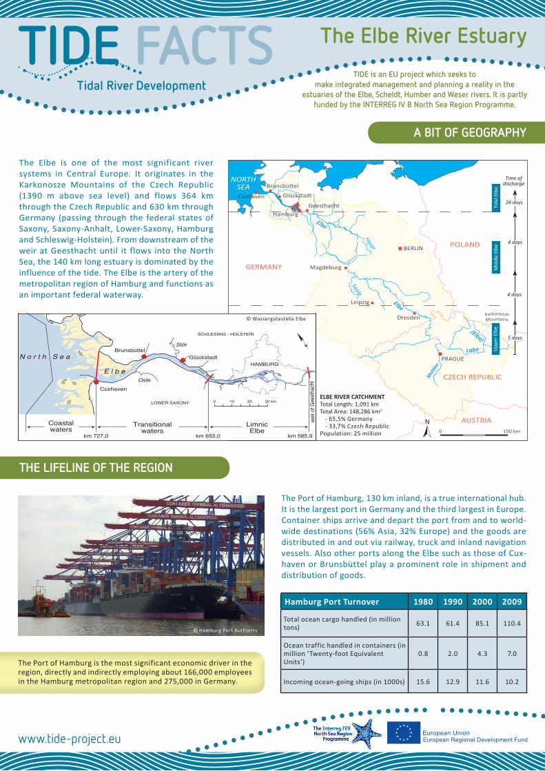
Brunsbüttel
Cuxhaven
Hamburg
Glückstadt
BERLIN
Leipzig
Dresden
PRAGUE
Geesthacht
Karkonosze Mountains
Magdeburg
150 km0
POLAND
CZECH REPUBLIC
AUSTRIA
GERMANY
NORTHSEA
The Port of Hamburg, 130 km inland, is a true international hub. It is the largest port in Germany and the third largest in Europe. Container ships arrive and depart the port from and to world-wide destinations (56% Asia, 32% Europe) and the goods are distributed in and out via railway, truck and inland navigation vessels. Also other ports along the Elbe such as those of Cux-haven or Brunsbüttel play a prominent role in shipment and distribution of goods.
Tidal River Development
The Elbe River EstuaryTIDE FACTSA BIT OF GEOGRAPHY
The Elbe is one of the most significant river systems in Central Europe. It originates in the Karkonosze Mountains of the Czech Republic (1390 m above sea level) and flows 364 km through the Czech Republic and 630 km through Germany (passing through the federal states of Saxony, Saxony-Anhalt, Lower-Saxony, Hamburg and Schleswig-Holstein). From downstream of the weir at Geesthacht until it flows into the North Sea, the 140 km long estuary is dominated by the influence of the tide. The Elbe is the artery of the metropolitan region of Hamburg and functions as an important federal waterway.
THE LIFELINE OF THE REGION
Hamburg Port Turnover 1980 1990 2000 2009
Total ocean cargo handled (in million tons) 63.1 61.4 85.1 110.4
Ocean traffic handled in containers (in million ‘Twenty-foot Equivalent Units’)
0.8 2.0 4.3 7.0
Incoming ocean-going ships (in 1000s) 15.6 12.9 11.6 10.2
The Port of Hamburg is the most significant economic driver in the region, directly and indirectly employing about 166,000 employees in the Hamburg metropolitan region and 275,000 in Germany.
TIDE is an EU project which seeks to make integrated management and planning a reality in the
estuaries of the Elbe, Scheldt, Humber and Weser rivers. It is partly funded by the INTERREG IV B North Sea Region Programme.
5 days
4 days
26 days
Time ofdischarge
Mid
dle
Elbe
Upp
er E
lbe
Tida
l Elb
e
ELBE RIVER CATCHMENTTotal Length: 1,091 kmTotal Area: 148,286 km2
- 65,5% Germany- 33,7% Czech Republic
Population: 25 million
4 days
N
N
HAMBURG
LOWER SAXONY
SCHLESWIG - HOLSTEIN
Glückstadt
Oste
LimnicElbe
km 585,9km 655,0km 727,0
0 10 20 30 km
Coastalwaters
Transitionalwaters
Cuxhaven
E l b e
BrunsbüttelStör
weir o
f Gee
sthac
ht
N o r t h S e a
© Wassergütestelle Elbe
© Hamburg Port Authority
www.tide-project.eu

A HISTORY OF CHANGES
NATURA 2000 is a Europe-wide network of natural heritage sites tasked with ensuring the long-term preservation of Europe’s most valuable and threatened species and habitats. There are nearly 26,000 protected areas, covering more than 850,000 km2 (about 18% of total EU terrestrial area). In the Elbe estuary, 12 Special Pro-tected Areas contribute to the NATURA 2000 network, covering about 90% of the estuary’s water and foreshore surface areas.
© Behörde für Stadtentwicklung und Umwelt
sector is ever growing. In addition to its appeal to nature lovers, the river is a stomping ground for water sports, angling and beach life.
The Elbe estuary has a rich fish population and its shal-low water zones are impor-tant spawning and hatching areas. Fishing continues to be a traditional use in the region. The majority of the fish volume is smelt (Os-merus eperlanus), which people consume as a delica-
tessen in spring, when it migrates upstream to reproduce. How-ever, eel (Anguilla anguilla) is economically the most important fish. Prawn fishing is also typical in the mouth of the estuary.
Agriculture is the most prevalent land utilization in the Lower Elbe region, with its orchards enjoying an international reputa-tion. The Elbe irrigates and drains the farmland maintaining very fertile soils in the area.
A HAVEN FOR PEOPLE AND WILDLIFE
This dynamic estuary is a unique habitat for highly specialized flora and fauna, with some endemic species only found here, like the aquatic plant “Elbe Water Dropwort” (Oenanthe conioides) and the “Elbe Hair Grass” (Deschampsia wibeliana). A population of seals, which follow the fish into the estuary, lives permanently on the sandbanks near Brunsbüttel. Porpoises (Phocoenaphoc-oena) can also be found occasionally. With its wet-lands, mudflats and fore-shore areas, its reeds and alluvial forests, the estuary is an ecological haven for mi-gratory birds. Approximately 30 nature protection areas (under national law) can be found along the Tidal Elbe.
As a local recreation destina-tion with a unique land-scape, the area’s tourism
Fish diversity and abundance have increased since the early 1990s due to major improvements in water quality. Some red listed fish species have even made a come back! With 79 species, the Tidal Elbe has the highest fish diversity of all European rivers.
www.tide-project.eu
As a result of strong tides and massive sediment transport, the shape of the Elbe estuary is highly diverse and continuously changing. Its mouth is characterized by a steadily moving mul-tiple channel system. Naturally dynamic channels and side arms are also typical further upstream. In Hamburg, the Elbe forms an inland delta, where the port lies today. Seabed dunes and ripples, intertidal areas, sand banks and islands are all con-stantly shifting.
Ever since men settled, the development of the region and its increasing population interfered with the natural development of the estuary. They led to modifications of the river and con-struction of dikes and barriers, which kept the marshlands from growing through sedimentation and keeping pace with the rising river water level. Today roughly half of the entire river length is protected by embankments.
The river has also seen large-scale changes as a navigable wa-terway. As a result of industrialization and growth of the mer-chant fleet at the beginning of the 20th century, many water engineering measures were put in place such as the expansion of harbour basins and several deepenings of the fairway.
To keep meeting shipping requirements, the Elbe fairway and har-bour basin in Hamburg have been deepened from a depth of 4.5 m in 1843 to 13.5 m, with a current deepening to 14.5 m under way.
The evolution of the Elbe fairway over time

THE CHALLENGE OF MAINTAINING THE FAIRWAY
Since the early 1980s, the Elbe is known as one of the most con-taminated rivers in Europe. Contaminant loads originate mostly from earlier inputs and are to be found mainly in the sediments.
IMPROVING WATER AND SEDIMENT QUALITY
However, since the International Commission for the Protection of the Elbe River was established in 1990, the Czech Republic and Germany have worked together to improve water and sedi-ment quality status, with noticeable results.
Given the contamination of the material being dredged, the Port of Hamburg had to develop a custom-fit sediment management strategy. This involved the treatment of contaminated dredged material and its deposition ashore. However, since the mid 1990s, the improved quality of sediments has allowed for the relocation of lightly contaminated sediments back into the river and the North Sea.
Occasionally during summer months, oxygen levels in the water become a problem, particularly downstream of Hamburg. The Elbe river receives a high input of nutrients originating from the whole catchment area. This nutrient load leads to algae blooms. When the algae biomass dies in the deeper parts of the estuary due to light limitation, their degradation by microbes causes heavy oxygen consumption and depletion. The low water oxy-gen levels can, in turn, affect fish and other aquatic species.
For the Elbe, the tidal period is asymetrical, which means that the flood period is shorter than the ebb period. The speed of the flood current is thus higher than that of the ebb current. These two facts, exacerbated by numerous human induced changes over many decades, have led to a heavy upstream transport of sediments, a process called tidal pumping. Since the weaker ebb current is insufficient to bring all the sediments back out to the river mouth and the North Sea, material depos-its and accumulates in the Hamburg region. This process will be enhanced in summer months during low freshwater discharge.
This tidal pumping is a major challenge for the maintenance of the navigable fairway. The volume of material dredged in the Hamburg area has increased considerably within the last ten years. Climate change is expected to exacerbate these issues, through increased high water levels inducing a higher tidal range and thus strengthening the tidal pumping effect.
FLOOD TIDENorth Sea
Brunsbüttel GlückstadtHamburg
strong current
river bed
EBB TIDE
North Sea
weak current
Brunsbüttel GlückstadtHamburg
river bed
© Hamburg Port Authority
Scientist collecting water samples to monitor water quality
As a tidally influenced water body, the tidal wave enters the Elbe at the mouth of the estuary and moves far inland. It is then stopped by a weir at Geesthacht, upstream of Hamburg.
TIDAL CYCLETide changes twice a day
Flood period:5 hrs 5 minEbb period:7 hrs 20 min
TIDAL RANGE2.9 m at Cuxhaven3.6 m in Hamburg
2.3 m at Geesthacht
FRESHWATER DISCHARGE
Range:200 - 3600 m3/s
Average:700 m3/s
Most frequent:300 m3/s
A NEW CONCEPT FOR THE FUTURE
To stop the unfavorable changes to the river’s characteristics resulting from past developments, the Hamburg Port Authority and the Waterways and Shipping Administration have developed a concept intended to mitigate tidal energy, sediment transport and dredging necessity, while simultane-ously affording benefits for the conservation of habitats, the enhancement of biodiversity and many other demands such as those of fishery.
The concept is focused on three main objectives to achieve sustainable development: (1) establishment of new shallow
In Germany, the Elbe river is a federal waterway owned by the Waterways and Shipping Administration (WSV), who is respon-sible for its maintenance. In the state area of Hamburg, how-ever, the management of the waterway is delegated to the City of Hamburg, represented by the Hamburg Port Authority.
The implementation of European directives is a task of the federal states and the Federal Government. To preserve the protected Elbe estuary habitat within the network of Natura
INTEGRATING THE MANAGEMENT OF THE ESTUARY
2000, the federal states and the WSV are drawing up an inte-grated management plan. It is intended to integrate economical and ecological demands through a set of proposed measures taking into account many aspects such as maintenance of the fairway, agriculture and recreation. The plan is not legally binding, it is aimed at voluntary commitment of stakeholders. Planning groups have been established to cooperate with all stakeholders, with regular input meetings along the way.
water areas in the upper part of the estuary, (2) optimization of sediment management, and (3) dissipation of incoming tidal energy by near-natural river engineering measures.
Further, HPA has inititated the TIDE project in an effort to look towards other North Sea Region estuaries for new insights, suggestions regarding factors of influence on estuary dynamics, experiences with mitigation measures, and further knowledge about improved governance structures which could be applied in the Tidal Elbe.
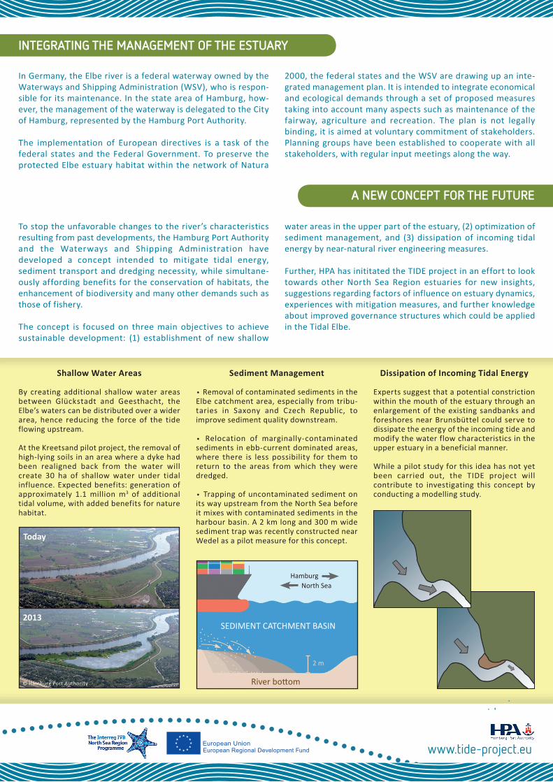
Sediment Management
∙ Removal of contaminated sediments in the Elbe catchment area, especially from tribu-taries in Saxony and Czech Republic, to improve sediment quality downstream.
∙ Relocation of marginally-contaminated sediments in ebb-current dominated areas, where there is less possibility for them to return to the areas from which they were dredged.
∙ Trapping of uncontaminated sediment on its way upstream from the North Sea before it mixes with contaminated sediments in the harbour basin. A 2 km long and 300 m wide sediment trap was recently constructed near Wedel as a pilot measure for this concept.
Dissipation of Incoming Tidal Energy
Experts suggest that a potential constriction within the mouth of the estuary through an enlargement of the existing sandbanks and foreshores near Brunsbüttel could serve to dissipate the energy of the incoming tide and modify the water flow characteristics in the upper estuary in a beneficial manner.
While a pilot study for this idea has not yet been carried out, the TIDE project will contribute to investigating this concept by conducting a modelling study.
Shallow Water Areas
By creating additional shallow water areas between Glückstadt and Geesthacht, the Elbe’s waters can be distributed over a wider area, hence reducing the force of the tide flowing upstream.
At the Kreetsand pilot project, the removal of high-lying soils in an area where a dyke had been realigned back from the water will create 30 ha of shallow water under tidal influence. Expected benefits: generation of approximately 1.1 million m3 of additional tidal volume, with added benefits for nature habitat.
Today
2013
© Hamburg Port Authority
SEDIMENT CATCHMENT BASIN
North SeaHamburg
River bottom
2 m
www.tide-project.eu