this page left intentionally blank. - michigan · iv. identification of historic properties a. list...
TRANSCRIPT


This page left intentionally blank.

STATE HISTORIC PRESERVATION OFFICEApplication for Section 106 Review
SHPO Use OnlyIN Received Date / / Log In Date / /
OUT Response Date / / Log Out Date / /
Sent Date / /
Submit one copy for each project for which review is requested. This application is required. Please type. Applicationsmust be complete for review to begin. Incomplete applications will be sent back to the applicant without comment. Sendonly the information and attachments requested on this application. Materials submitted for review cannot be returned.Due to limited resources we are unable to accept this application electronically.
I. GENERAL INFORMATIONTHIS IS A NEW SUBMITTAL THIS IS MORE INFORMATION RELATING TO ER# 08-462
a. Project Name: Woodward Avenue Light Rail Transit Project - Phased Sec. 106 Submittal; see Attachment A.b. Project Address (if available): Generally Woodward Avenue from Downtown Detroit to Michigan State
Fairgrounds/8 Mile Road.c. Municipal Unit: Detroit and Highland Park County: Wayned. Federal Agency, Contact Name and Mailing Address (If you do not know the federal agency involved in your
project please contact the party requiring you to apply for Section 106 review, not the SHPO, for thisinformation.): Tricia Harr, AICP, Environmental Protection Specialist, Federal Transit Administration, 1200New Jersey Avenue SE, E43-105, Washington, DC, 20590; 202-366-0486 or [email protected]
e. State Agency (if applicable), Contact Name and Mailing Address: N/Af. Consultant or Applicant Contact Information (if applicable) including mailing address: Tim Roseboom, Project
Manager, Detroit Department of Transportation, 1301 East Warren, Detroit, MI, 48207; 313-833-1196 [email protected]
II. GROUND DISTURBING ACTIVITY (INCLUDING EXCAVATION, GRADING, TREE REMOVALS,UTILITY INSTALLATION, ETC.)
DOES THIS PROJECT INVOLVE GROUND-DISTURBING ACTIVITY? YES NO (If no, proceed to section III.)
Exact project location must be submitted on a USGS Quad map (portions, photocopies of portions, and electronicUSGS maps are acceptable as long as the location is clearly marked).
a. USGS Quad Map Name: Detroit and Highland Park, Attachment B.b. Township: T2S Range: R12E Section: N/Ac. Description of width, length and depth of proposed ground disturbing activity: See Attachment A.d. Previous land use and disturbances: See Attachment A.e. Current land use and conditions: See Attachment A.f. Does the landowner know of any archaeological resources found on the property? YES NO
Please describe:
III. PROJECT WORK DESCRIPTION AND AREA OF POTENTIAL EFFECTS (APE)Note: Every project has an APE.
a. Provide a detailed written description of the project (plans, specifications, Environmental Impact Statements(EIS), Environmental Assessments (EA), etc. cannot be substituted for the written description): SeeAttachments A and C.
b. Provide a localized map indicating the location of the project; road names must be included and legible.c. On the above-mentioned map, identify the APE.d. Provide a written description of the APE (physical, visual, auditory, and sociocultural), the steps taken to
identify the APE, and the justification for the boundaries chosen. See Attachment A.

IV. IDENTIFICATION OF HISTORIC PROPERTIES
a. List and date all properties 50 years of age or older located in the APE. If the property is located within a NationalRegister eligible, listed or local district it is only necessary to identify the district: See Attachments A and C.
b. Describe the steps taken to identify whether or not any historic properties exist in the APE and include the levelof effort made to carry out such steps: See Attachment A.
c. Based on the information contained in “b”, please choose one:Historic Properties Present in the APENo Historic Properties Present in the APE
d. Describe the condition, previous disturbance to, and history of any historic properties located in the APE: SeeAttachment A.
V. PHOTOGRAPHSNote: All photographs must be keyed to a localized map.
a. Provide photographs of the site itself.b. Provide photographs of all properties 50 years of age or older located in the APE (faxed or photocopied
photographs are not acceptable).
VI. DETERMINATION OF EFFECT
No historic properties affected based on [36 CFR § 800.4(d)(1)], please provide the basis for this determination.
No Adverse Effect [36 CFR § 800.5(b)] on historic properties, explain why the criteria of adverse effect, 36 CFRPart 800.5(a)(1), were found not applicable.
Adverse Effect [36 CFR § 800.5(d)(2)] on historic properties, explain why the criteria of adverse effect, [36 CFRPart 800.5(a)(1)], were found applicable.
Please print and mail completed form and required information to:State Historic Preservation Office, Environmental Review Office, Michigan Historical Center, 702
W. Kalamazoo Street, P.O. Box 30740, Lansing, MI 48909-8240

Attachment A Additional Information for
Application for Section 106 Review

This page left intentionally blank.

November 2010)Woodward Avenue Light Rail Transit Project (ER# 08-462)Phased Section 106 Submittal – Grand Boulevard to M-8/Davison Freeway (November 2010)
Attachment A – Additional Information for Application for Section 106 Review
Section I. General Information
NOTE: A phased historic property identification effort and effects assessment was deemedappropriate for the Woodward Avenue Light Rail Transit (LRT) project and coordinated with theState Historic Preservation Office (SHPO); see response to Section IV, Part A. The encloseddocumentation assesses project effects to properties listed in or determined eligible for listing inthe National Register of Historic Places (NRHP) located within the portion of the project’s Areaof Potential Effects (APE) along Woodward Avenue between Grand Boulevard and MichiganRoute 8 (M-8)/Davison Freeway. Therefore, information provided in this Application for Section106 Review and in its attachments describes both the general project and the specific portion ofthe project area between Grand Boulevard and M-8/Davison Freeway, as relevant.Documentation identifying built resources more than forty years of age located within theproject’s APE along Woodward Avenue between Grand Boulevard and M-8/Davison Freewayhas been concurrently submitted for SHPO review. Four reports were previously submitted forSHPO review. These reports included eligibility determinations for properties located fromDowntown Detroit to Interstate 75 (I-75)/Fisher Freeway, in “Phased Section 106 Submittal,Downtown Detroit to Interstate 75/Fisher Freeway” (September 2010); eligibility determinationsfor properties from I-75/Fisher Freeway to Grand Boulevard, in “Phased Section 106 Submittal,Interstate 75/Fisher Freeway to Grand Boulevard” (September 2010); effects determinations forhistoric properties from Downtown Detroit to I-75/Fisher Freeway, in “Phased Section 106Submittal, Assessment of Effects, Downtown Detroit to Interstate 75/Fisher Freeway” (October2010); and effects determinations for historic properties from I-75/Fisher Freeway to GrandBoulevard, in “Phased Section 106 Submittal, Assessment of Effects, Interstate 75/FisherFreeway to Grand Boulevard” (October 2010). A forthcoming report will contain determinationsof eligibility and effects for the remaining portion of the project corridor between M-8/DavisonFreeway and M-102/8 Mile Road.
Section II. Ground Disturbing Activity
c. Describe the proposed dimensions of ground disturbing activity. Plans andspecifications should not be substituted here. Example: 4 feet wide, 20 feet long, 2 feetdeep.
The Woodward Avenue LRT project would extend approximately 8.5 miles from DowntownDetroit near the Detroit River north to 8 Mile Road along Woodward Avenue; total project length,including circulation in Downtown Detroit, would be 9.3 linear miles. The majority of the projectcorridor falls within the City of Detroit, with approximately two miles (from Webb Street toMcNichols Street) located within the City of Highland Park. All rail line construction, includingthe guideway, tracks, rails, overhead contact system (OCS) poles, and stations, would occurwithin existing roadway rights-of-way and within travel lanes and/or median areas/sidewalks.The width and depth of ground disturbance would vary from approximately 28 to 48 feet wideand from 0 to 3 feet deep.
Potential vehicle storage and maintenance facility (VSMF) sites have been identified. Theseareas, along with appropriate adjacent parcels, have been included in the APE. VSMF designwould be site specific and include a yard and various industrial buildings. No VSMF sites arelocated within the project area between Grand Boulevard and M-8/Davison Freeway, the areathat this submittal addresses. This report addresses potential effects to aboveground historic
Attachment A – Additional Information for Application for Section 106 ReviewWoodward Avenue Light Rail Transit Project (ER# 08-462)Phased Section 106 Submittal - Assessment of Effects - Grand Boulevard to M-8/Davison Freeway (November 2010)
2
properties; forthcoming archaeological reports will address potential effects to below-groundhistoric properties.
d. Describe the previous use of the land. Was it farm land, an industrial site, ahomestead, etc.? Was there a utility corridor placed on the property, were sewer andwaterlines placed there 10 years ago, etc.?
Woodward AvenueOriginally a Native American trail, Woodward Avenue became the main thoroughfare for the Cityof Detroit and eventually stretched twenty-seven miles from the Detroit River in urbanDowntown Detroit through rural and later suburban areas northwest of the city to the City ofBloomfield Hills. In 1863, horse-drawn rail car lines were installed along four major DowntownDetroit roads, including Woodward Avenue from Jefferson Avenue to Alexandrine Street.Electric streetcar service replaced horse-drawn rail cars in late 1892.
In 1908, the world’s first mile of concrete roadway was built on Woodward Avenue between 6Mile and 7 Mile roads. The entire twenty-seven-mile length of Woodward Avenue was paved in1916, and the nation’s first three-color, four-way traffic light was installed in 1919 at theWoodward Avenue and Michigan Avenue intersection. After many legal disputes, WoodwardAvenue was widened from 66 feet to 120 feet in 1936. The widening resulted in the demolition,relocation, or renovation of numerous buildings along the road. Streetcar operations alongWoodward Avenue ended in April 1956. Today, the Detroit People Mover, a 2.9-mile elevatedlight rail system, provides local service between buildings and neighborhoods in DowntownDetroit.
Downtown Detroit and Midtown AreaThe historic core from which the rest of the city later developed was located from the DetroitRiver to what is now I-75/Fisher Freeway. Through the nineteenth and twentieth centuries, thecity steadily expanded northward with farmland giving way to residential neighborhoods,commercial buildings, factories, universities, and municipal and cultural institutions. This areacontains numerous office towers, churches, theaters, and smaller commercial buildingsconstructed in a variety of architectural styles, including Art Deco, Beaux Arts, Chicago Style,Gothic Revival, Romanesque Revival, and modern styles. The stretch of Woodward Avenuefrom Grand Circus Park to Mack Avenue was known as Piety Hill due to the numerous churcheslocated in that area. In the early twentieth century, the construction of the Italian Renaissance-style Detroit Public Library, the Beaux Arts-style Detroit Institute of Arts, and portions of theWayne State University campus created Detroit’s Cultural Center in the Midtown area. Midtownis the area located approximately between the north end of Downtown Detroit and the NewCenter area near the Woodward Avenue and Grand Boulevard intersection. The CulturalCenter was later expanded in the mid-twentieth century with the construction of the Prairie-styleDetroit Historical Museum and other cultural institutions.
New Center AreaNew Center developed in the 1920s in response to the increase in automotive factories andindustries in the area. This development and the creation of a small commercial and businesscore led to extensive residential development of the surrounding areas that housed workersassociated with New Center’s factories and commercial enterprises. A three-block commercialdistrict developed on Woodward Avenue; it includes two- and three-story brick commercialbuildings in the Neoclassical and Art Deco styles. The General Motors Corporation and theFisher family, prominent local real estate developers, constructed Neoclassical-style and Art

Attachment A – Additional Information for Application for Section 106 ReviewWoodward Avenue Light Rail Transit Project (ER# 08-462)Phased Section 106 Submittal - Assessment of Effects - Grand Boulevard to M-8/Davison Freeway (November 2010)
3
Deco-style skyscrapers along Grand Boulevard to the west of Woodward Avenue and the NewCenter commercial district.
North of New Center, the neighborhoods of Virginia Park, Arden Park, and Boston-Edisondeveloped in the early twentieth century as enclaves for the middle class, upper middle class,and the wealthy. The neighborhoods feature a mix of homes and mansions including Prairie,Craftsman, and English Revival architectural styles.
Highland ParkAlong Woodward Avenue, the City of Highland Park stretches from Webb Street to McNicholsRoad. Highland Park incorporated as a village in 1889 and as a city in 1918. The location ofthe Highland Park Ford Plant along Woodward Avenue spurred the development of thecommunity from a small farming village to an urban industrial center. Commercial buildings,apartment buildings, and church buildings on Woodward Avenue were constructed in the GothicRevival, Beaux Arts, Renaissance Revival, and Craftsman architectural styles; they vary inheight from two to eight stories, depending on the building type. Residential neighborhoodslocated approximately one block east and west of Woodward Avenue commonly include theAmerican Foursquare and bungalow forms in the Craftsman, Prairie, and English Revival styles.In 1944, the world’s first limited-access urban expressway, the Davison Freeway, was openedthrough the city center. The closure of the Highland Park Ford Plant in the late 1950scontributed to population and economic declines in the city.
The portion of the APE considered in this application, between Grand Boulevard and M-8/Davison Freeway, is in the middle, northern section of the study area. The APE in this areaencompasses portions of Detroit’s New Center area and the City of Highland Park.
Palmer Park AreaThe City of Detroit jurisdiction resumes north of McNichols Road and includes Palmer Park andthe Palmer Woods neighborhood. Palmer Park is a large 270-acre public park and golf coursedeeded to the city in 1893. Constructed prior to World War II, the apartment buildings south ofPalmer Park include the Egyptian, Spanish, Mediterranean, Venetian, Tudor, and Moorishrevival styles, and the Art Moderne and International styles. North of Palmer Park is the PalmerWoods neighborhood that developed from farmland in the 1920s as an upper-class classneighborhood of large Tudor Revival-style homes. North of Palmer Park and the Palmer Woodsneighborhood are the Evergreen and Woodlawn cemeteries, which date to 1905 and 1895,respectively. The sprawling Michigan State Fairgrounds are located on the east side ofWoodward Avenue between West State Fair Avenue and 8 Mile Road. Organized in Detroit in1849, the fairgrounds were moved to their present location in 1905. The main fairgroundbuildings were constructed in the Neoclassical style typical of fair architecture in the earlytwentieth century; various buildings within the complex also represent Greek Revival, Arts andCrafts, and modern styles.
e. Describe the current use and condition of the property.
The Woodward Avenue LRT project traverses a diverse area containing commercial,institutional, civic, recreational, industrial, and residential uses. Woodward Avenue remains amajor thoroughfare from the Detroit River and the Central Business District of Downtown Detroitnorth to 8 Mile Road. Throughout the proposed project corridor along Woodward Avenue,commercial, institutional, and industrial land use is most common, with sprawling residentialareas frequently located beyond development immediately fronting Woodward Avenue. Bothmodern redevelopment and vacant and cleared land is most common between I-75/Fisher
Attachment A – Additional Information for Application for Section 106 ReviewWoodward Avenue Light Rail Transit Project (ER# 08-462)Phased Section 106 Submittal - Assessment of Effects - Grand Boulevard to M-8/Davison Freeway (November 2010)
4
Freeway and I-94/Ford Freeway. Despite some modern development, older buildings andneighborhoods are located throughout the corridor. Many historic buildings and neighborhoodsalong Woodward Avenue have been listed in the NRHP and/or have been locally designated ashistoric by the appropriate local municipality or by the State of Michigan.
The portion of the APE considered in this application, between Grand Boulevard and M-8/Davison Freeway, is in the middle, northern section of the study area. The APE in this areaencompasses portions of Detroit’s New Center area and the City of Highland Park. The NewCenter area includes a mix of commercial, civic, and residential buildings, including the historicVirginia Park residential neighborhood. North of the New Center Area, other prominent sitesinclude the historic Boston-Edison and Arden Park-East Boston neighborhoods. The City ofHighland Park also includes a mix of commercial, residential, and civic buildings, including thehistoric Highland Heights-Stevens Subdivision neighborhood, the McGregor Library, and theCity of Highland Park Robert B. Blackwell Municipal Building.
Section III. Project Work Description and APE
a. Provide a detailed written description of the project.
The Woodward Avenue LRT project would consist of an approximately 9-mile fixed guidewayLRT system located primarily along the Woodward Avenue corridor in Detroit and HighlandPark, Michigan (see Attachment C). The project alignment would extend from DowntownDetroit to M-102/8 Mile Road. The proposed system would use steel-wheel LRT vehicles with atypical train consisting of two cars. The system would be street running.
Three design options are being considered. Within downtown Detroit, the guideway would beinstalled in existing streets with the light rail train sharing the roadway with vehicular traffic. Eachdesign option follows a unique alignment through the downtown area. North of the downtownarea and south of Custer Street, the LRT would be located on the Woodward Avenue corridor,either in the median or along the rightmost travel lane in both the northbound and southbounddirections. From Custer Street to the project’s northern terminus proximate to the MichiganState Fairgrounds, just south of M-102/8 Mile Road, the three design options are identical; inthis area, the alignment would generally be located in the median of Woodward Avenue.
Downtown Design OptionsThree design options are being considered (see Attachment B).
Downtown Design Option 1This design option provides circulation within portions of the downtown area. A loop wouldinclude one-way guideway alignments utilizing Larned, Randolph, and Congress streets viaWashington Boulevard. In the downtown loop, the guideway would be installed in the existingstreet with the light rail train sharing the roadway with existing traffic. A two-way guidewaywould follow Washington Boulevard north to Grand River Avenue and would be located in themedian. At Grand River Avenue, the alignment would turn east along that street and then turnnorth onto Woodward Avenue. Along Grand River Avenue, Washington Boulevard, and thedowntown loop, the guideway would be installed in the existing street with the light rail trainsharing the roadway with vehicular traffic.
From Custer Street to the project’s northern terminus, Design Option 1 would be located in themedian of Woodward Avenue, separate from vehicular traffic.

Attachment A – Additional Information for Application for Section 106 ReviewWoodward Avenue Light Rail Transit Project (ER# 08-462)Phased Section 106 Submittal - Assessment of Effects - Grand Boulevard to M-8/Davison Freeway (November 2010)
5
Downtown Design Option 2: This design option generally follows the same streets along aslightly different alignment in the downtown area as Design Option 1; however, fromWashington Boulevard, it is routed to the east along State Street before turning north ontoWoodward Avenue.
From State Street north to Custer Street, Design Option 2 would be located along the right-mosttravel lane of Woodward Avenue in both the northbound and southbound directions.
From Custer Street to the project’s northern terminus, Design Option 2 would be located in themedian of Woodward Avenue, separate from vehicular traffic.
Downtown Design Option 3: This option is located within Woodward Avenue along its entireroute. It would originate in the downtown area between Larned and Congress streets. Just northof this point, the guideway would circumnavigate Campus Martius Park.
From Campus Martius Park to Custer Street, the guideway would be located along the right-most travel lane of Woodward Avenue in both the northbound and southbound directions.
From Custer Street to the project’s northern terminus, Design Option 3 would be located in themedian of Woodward Avenue, separate from vehicular traffic.
Project Elements and FacilitiesThe proposed LRT system would require the construction of several supporting projectelements and facilities, including trackwork, a traction electrification system, transit powersubstations, a vehicle storage maintenance facility, and LRT stations. A brief description ofeach follows:
Trackwork: The light rail system would run on steel tracks at a standard gauge of 4 feet, 8.5inches. The tracks would be located exclusively within existing road rights-of-way, except nearthe vehicle storage maintenance facility (site unconfirmed at this time). Portions of theguideway would be exclusive to light rail operations; however, some areas would circulate invehicular traffic. The trackwork would be embedded in the pavement.
Traction Electrification System: A simple catenary system would be used for the traction powercontact system. The Overhead Contact System (OCS) would consist of support poles andwires providing electrification to the light rail vehicles. These features would be located alongthe proposed route and situated in existing road rights-of-way.
Transit Power Substations: Spaced along the proposed route at approximately 1-mile intervals,these substations would supply power to the LRT system. The substations’ precise locationshave not been determined at this time.
Vehicle Storage and Maintenance Facility: A facility would be required to store and maintain thelight rail vehicles. Typical functions at this location would include vehicle storage, paint booth,lifts, pits, wheel truing, wash bays, and associated administrative functions. It is expected thatthe site selected would be: 1) no less than five acres in size; 2) close to the transit alignment;and 3) located in an area consistent in land use and zoning. Selection of a preferred site isongoing. Three potential sites for this facility have been identified; none of these sites arelocated in the area that is the subject of this application.

Attachment A – Additional Information for Application for Section 106 ReviewWoodward Avenue Light Rail Transit Project (ER# 08-462)Phased Section 106 Submittal - Assessment of Effects - Grand Boulevard to M-8/Davison Freeway (November 2010)
6
LRT Stations: Major features of the LRT stations would be the platforms and shelters. Theplatform length is derived from the length of the LRT vehicles, and with the two-car trainsproposed for the Woodward Avenue LRT project, a typical near-grade platform for proposedLRT stations between Grand Boulevard and M-8/Davison Freeway would be 200 feet (two 90-foot vehicles plus approximately 20 feet for loading space and milling area). The platformswould have access ramps (up to 24 feet long) and landing areas (up to 6 feet) to providepedestrian access to the platforms. Given the various site conditions at stations along theproposed route, total station length would vary from 180 to 260 feet. Typical width would be 18to 24 feet for double-sided platforms, and approximately 12 feet for single-sided platforms;typical platform height would be 14 inches to accommodate the proposed low-floor LRTvehicles. Stations proposed as part of Design Options 2 and 3 would have roof-mountedbillboards atop each station.
Station shelters may be designed with a signature look and/or be context-sensitive to therespective setting at each site. They protect waiting passengers from the elements and caninclude special features such as passenger displays, sound systems, lighting, and heatingelements. Other facilities and station furniture would also include ticket vending and securityequipment, schedule and area information cases, railings, benches, and litter receptacles.
Four station locations are proposed along Woodward Avenue between Grand Boulevard and M-8/Davison Freeway, including at Hazelwood Street/Holbrook Street, Calvert Street, andGlendale Street. The northbound Grand Boulevard station platform proposed as part of DesignOptions 2 and 3 would also be located within this area, immediately north of Grand Boulevard.
d. Provide a written description of the APE (physical, visual, auditory, and sociocultural),the steps taken to identify the APE, and the justification for the boundaries chosen.
The APE for the Woodward Avenue LRT project encompasses roadways within which the LRTwould be located, all properties flanking those roadways, and properties for which the LRT or itscomponents would be a prominent visual feature (see Attachment C). For visualconsiderations, the APE encompasses properties that do not directly adjoin the project corridor,but are otherwise located proximate to it or to a project facility. For example, a building notadjoining but directly facing a Woodward Avenue LRT roadway at an intersection, or a buildingseparated from the proposed project corridor by a vacant lot or parking lot would be included inthe APE. Properties surrounding or in proximity to three potential sites for the VSMFs and forwhich that facility would be a prominent visual feature have also been included in the APE.
The APE was developed by utilizing preliminary project plans in conjunction with field surveys ofthe project corridor and consultation with project noise and vibration specialists. Because noauditory or vibratory impacts are anticipated, the APE was developed to encompass potentialvisual and physical effects related to facility construction near the project corridor. Toencompass effects in the immediate vicinity of the project alignment, all roadways within whichthe LRT would be located and flanking properties have been included in the APE. Additionalconsideration was given to viewshed impacts and effects to setting beyond these properties.Properties determined to be subject to a potential visual effect were identified and included inthe APE; the methodology employed is described below. No potential traditional culturalproperties have been identified. At this time, no changes to land use, traffic patterns, or publicaccess are anticipated. Transit-oriented development (TOD) planning is in preliminary stagesand will be evaluated for Section 106 purposes, if applicable and appropriate, when TODprojects are proposed.

Attachment A – Additional Information for Application for Section 106 ReviewWoodward Avenue Light Rail Transit Project (ER# 08-462)Phased Section 106 Submittal - Assessment of Effects - Grand Boulevard to M-8/Davison Freeway (November 2010)
7
During the field survey, project architectural historians who meet the Secretary of the Interior’sProfessional Qualification Standards reviewed the visual setting of properties that do not adjointhe project corridor but for which the project corridor is a visual component because of the lackof an intervening physical feature (for example, a property separated from the project corridor bya vacant lot). In general, the architectural historians determined that for such properties locatedwithin 250 feet of the proposed LRT guideway and OCS and/or a station (for both the Median-Running and Curb-Running alternatives), proposed project features would become a prominentcomponent of the property’s visual setting; therefore, such properties would be visually affectedby project implementation. For such properties beyond 250 feet, the architectural historiansdetermined that the LRT would not become a significant component of the property’s visualsetting; therefore, the Woodward Avenue LRT would not visually affect such properties. Thus,properties that do not immediately adjoin the project corridor but for which the proposedWoodward Avenue LRT was determined to be a prominent visual component have beenincluded in the APE. Following the selection of three potential sites for a proposed VMSF, theAPE was expanded in these areas to accommodate surrounding and proximate properties forwhich the facility would constitute a substantial visual change.
The APE for the Woodward Avenue LRT project was provided to the SHPO by letter from theDetroit Department of Transportation dated November 20, 2009; the SHPO concurred with theAPE by letter dated January 13, 2010. Because the project’s VSMF sites were only recentlyidentified, the APE has been expanded to accommodate these parcels, as well as adjacentparcels that would be potentially affected. Mapping showing this revised APE was submitted tothe SHPO on September 17, 2010, for concurrence.
Section IV. Identification of Historic Properties
a. List and date all properties 50 years of age or older located in the APE.
A historic property identification report, “Phased Section 106 Submittal, Grand Boulevard to M-8/Davison Freeway” (November 2010), that presents determinations of eligibility is beingconcurrently submitted to the SHPO. A phased historic property identification and effectsassessment was deemed appropriate for the Woodward Avenue LRT project and coordinatedwith the SHPO to avoid a single large submittal, as well as to provide project architecturalhistorians with valuable feedback from SHPO staff that can be incorporated into the futuresubmittals. This report identifies built resources more than forty years of age located within theproject’s APE between Grand Boulevard and M-8/Davison Freeway. Properties forty years ofage or older (rather than the standard fifty-year age limit) were evaluated to accommodate theWoodward Avenue LRT’s construction schedule.
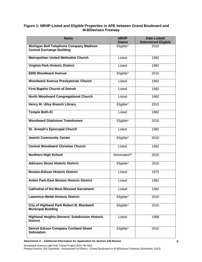
The historic property identification report contained documentation on seventy-three resourcesmore than forty years of age located within the APE between Grand Boulevard and M-8/DavisonFreeway. Of these, fifteen were previously listed in the NRHP, and one was formally nominatedto the NRHP. Of the fifty-seven resources that were previously not identified and/or evaluatedfor NRHP eligibility, twelve were determined to be eligible for listing. Therefore, the currentsubmittal evaluates potential project effects to twenty-eight properties listed in or determinedeligible for the NRHP; these properties are listed in the table (Figure 1) below.
Attachment A – Additional Information for Application for Section 106 ReviewWoodward Avenue Light Rail Transit Project (ER# 08-462)Phased Section 106 Submittal - Assessment of Effects - Grand Boulevard to M-8/Davison Freeway (November 2010)
8
Figure 1: NRHP-Listed and Eligible Properties in APE between Grand Boulevard andM-8/Davison Freeway
Name NRHPStatus
Date Listed/Determined Eligible
Michigan Bell Telephone Company MadisonCentral Exchange Building
Eligible* 2010
Metropolitan United Methodist Church Listed 1982
Virginia Park Historic District Listed 1982
8300 Woodward Avenue Eligible* 2010
Woodward Avenue Presbyterian Church Listed 1982
First Baptist Church of Detroit Listed 1982
North Woodward Congregational Church Listed 1982
Henry M. Utley Branch Library Eligible* 2010
Temple Beth-El Listed 1982
Woodward Gladstone Townhomes Eligible* 2010
St. Joseph’s Episcopal Church Listed 1982
Jewish Community Center Eligible* 2010
Central Woodward Christian Church Listed 1982
Northern High School Nominated** 2010
Atkinson Street Historic District Eligible* 2010
Boston-Edison Historic District Listed 1975
Arden Park-East Boston Historic District Listed 1982
Cathedral of the Most Blessed Sacrament Listed 1982
Lawrence-Webb Historic District Eligible* 2010
City of Highland Park Robert B. BlackwellMunicipal Building
Eligible* 2010
Highland Heights-Stevens’ Subdivision HistoricDistrict
Listed 1988
Detroit Edison Company Cortland StreetSubstation
Eligible* 2010

Attachment A – Additional Information for Application for Section 106 ReviewWoodward Avenue Light Rail Transit Project (ER# 08-462)Phased Section 106 Submittal - Assessment of Effects - Grand Boulevard to M-8/Davison Freeway (November 2010)
9
Name NRHPStatus
Date Listed/Determined Eligible
Highland Park Presbyterian Church Listed 1982
Grace Evangelical Lutheran Church Listed 1982
Trinity United Methodist Church Listed 1982
YWCA Detroit Northern Branch Eligible* 2010
Highland Park Post Office Eligible* 2010
YMCA Detroit Northern Branch Eligible* 2010
* Determinations of eligibility pending SHPO concurrence. ** Pending NRHP listing.
b. Describe the steps taken to identify whether or not any historic properties exist in theAPE and include the level of effort made to carry out such steps.
Project architectural historians made several site visits to the project area and utilized publicproperty records to identify all properties within the APE older than forty years of age.Properties forty years of age or older (rather than the standard fifty-year age limit) wereevaluated to accommodate the Woodward Avenue LRT’s construction schedule.
The status of NRHP-listed properties and districts located within the APE were reviewed usingprevious NRHP documentation to determine if any properties had changed to the extent thatthey were no longer eligible for the NRHP or that NRHP boundaries should be altered. Duringthe current survey, architectural historians observed no substantial changes to any propertybetween Grand Boulevard and M-8/Davison Freeway that would alter its eligibility/listing status.Thus, no eligibility or boundary changes to NRHP-listed properties are recommended in thisportion of the project area.
Background research was conducted for each property not previously evaluated for listing in theNRHP. Sources consulted included public records, secondary published sources, and primarysources. Historians wrote detailed architectural descriptions and historic context statements.The NRHP criteria of eligibility were applied to each property and a determination of NRHPeligibility was made. This information is documented in survey data forms for each property.
All properties located in the APE between Grand Boulevard and M-8/Davison Freeway aredocumented in the “Phased Section 106 Submittal: Grand Boulevard to M-8/Davison Freeway”(November 2010) that is being concurrently submitted to the SHPO.
Section V. Photographs
See Attachment C.
Section VI. Determination of Effect
Evaluations included in Attachment C assess potential project effects to the twenty-eight NRHP-listed and NRHP-eligible historic properties within the Woodward Avenue LRT’s APE between

Attachment A – Additional Information for Application for Section 106 ReviewWoodward Avenue Light Rail Transit Project (ER# 08-462)Phased Section 106 Submittal - Assessment of Effects - Grand Boulevard to M-8/Davison Freeway (November 2010)
10
Grand Boulevard and M-8/Davison Freeway. The effects determinations are summarized inAttachment D.
MethodologyEffects assessments were based on the criteria of adverse effect as defined in 36 CFR 800.5“Assessment of adverse effects.” According to this portion of the regulations, the criteria ofadverse effect are defined as follows:
An adverse effect is found when an undertaking may alter, directly or indirectly, anyof the characteristics of a historic property that qualify the property for inclusion in theNational Register in a manner that would diminish the integrity of the property’slocation, design, setting, materials, workmanship, feeling, or association.Consideration shall be given to all qualifying characteristics of a historic property,including those that may have been identified subsequent to the original evaluationof the property’s eligibility for the National Register. Adverse effects may includereasonably foreseeable effects caused by the undertaking that may occur later intime, be farther removed in distance, or be cumulative.
Examples of adverse effects are identified in 36 CFR 800.5 and include, but are not limited to,the following:
Physical destruction of or damage to all or part of the property Alteration of a property, including restoration, rehabilitation, repair, maintenance,
stabilization, hazardous material remediation, and provision of handicappedaccess, that is not consistent with the Secretary’s Standards for the Treatment ofHistoric Properties (36 CFR 68) and applicable guidelines
Removal of the property from its historic location Change of the character of the property’s use or of physical features within the
property’s setting that contribute to its historic significance Introduction of visual, atmospheric, or audible elements that diminish the integrity
of the property’s significant historic features Neglect of a property which causes its deterioration, except where such neglect
and deterioration are recognized qualities of a property of religious and culturalsignificance to an Indian tribe or Native Hawaiian organization
Transfer, lease, or sale of property out of federal ownership or control withoutadequate and legally enforceable restrictions or conditions to ensure long-termpreservation of the property’s historic significance
NRHP bulletins do not address assessments of effects, as effects evaluations are related to theSection 106 process and not the Section 110 process in which the National Register guidance ismore commonly used. However, crucial information on integrity assessments (used foreligibility determinations) provides information regarding what each aspect of integrity entailsand how each aspect relates to the select National Register criteria for eligibility. As describedabove, retention of relevant aspects of integrity is critical to a property’s significance under theNRHP Criteria for Evaluation. The National Register Bulletin How to Apply the NationalRegister Criteria for Evaluation (NPS 1997) identifies the aspects of integrity and describes theirrelevance to the NRHP Criteria for Evaluation. The seven aspects of integrity are described inthe bulletin as follows:
Location is the place where the historic property was constructed or theplace where the historic event occurred. The relationship between theproperty and its location is often important to understanding why the property

Attachment A – Additional Information for Application for Section 106 ReviewWoodward Avenue Light Rail Transit Project (ER# 08-462)Phased Section 106 Submittal - Assessment of Effects - Grand Boulevard to M-8/Davison Freeway (November 2010)
11
was created or why something happened. The actual location of a historicproperty, complemented by its setting, is particularly important in recapturing thesense of historic events and persons.
Design is the combination of elements that create the form, plan, space,structure, and style of a property. It results from conscious decisions madeduring the original conception and planning of a property (or its significantalteration) and applies to activities as diverse as community planning,engineering, architecture, and landscape architecture. Design includes suchelements as organization of space, proportion, scale, technology, ornamentation,and materials. A property’s design reflects historic functions and technologies aswell as aesthetics. It includes such considerations as the structural system;massing; arrangement of spaces; pattern of fenestration; textures and colors ofsurface materials; type, amount, and style of ornamental detailing; andarrangement and type of plantings in a designed landscape.
Design can also apply to districts, whether they are important primarily for historicassociation, architectural value, information potential, or a combination thereof.For districts significant primarily for historic association or architectural value,design concerns more than just the individual buildings or structures locatedwithin the boundaries. It also applies to the way in which buildings, sites, orstructures are related.
Setting is the physical environment of a historic property. Whereas locationrefers to the specific place where a property was built or an event occurred,setting refers to the character of the place in which the property played itshistorical role. It involves how, not just where, the property is situated and itsrelationship to surrounding features and open space. Setting often reflects thebasic physical conditions under which a property was built and the functions itwas intended to serve. In addition, the way in which a property is positioned inits environment can reflect the designer’s concept of nature and aestheticpreferences.
The physical features that constitute the setting of a historic property can beeither natural or manmade, including such elements as: topographic features (agorge or the crest of a hill); vegetation; simple manmade features (paths orfences); and relationships between buildings and other features or open space.These features and their relationships should be examined not only within theexact boundaries of the property, but also between the property and itssurroundings. This is particularly important for districts.
Materials are the physical elements that were combined or depositedduring a particular period of time and in a particular pattern orconfiguration to form a historic property. The choice and combination ofmaterials reveal the preferences of those who created the property and indicatethe availability of particular types of materials and technologies. Indigenousmaterials are often the focus of regional building traditions and thereby helpdefine an area’s sense of time and place. A property must retain the key exteriormaterials dating from the period of its historic significance. If the property hasbeen rehabilitated, the historic materials and significant features must have beenpreserved.

Attachment A – Additional Information for Application for Section 106 ReviewWoodward Avenue Light Rail Transit Project (ER# 08-462)Phased Section 106 Submittal - Assessment of Effects - Grand Boulevard to M-8/Davison Freeway (November 2010)
12
Workmanship is the physical evidence of the crafts of a particular cultureor people during any given period in history or prehistory. It is the evidenceof artisans’ labor and skill in constructing or altering a building, structure, object,or site. Workmanship can apply to the property as a whole or to its individualcomponents. It can be expressed in vernacular methods of construction andplain finishes or in highly sophisticated configurations and ornamental detailing.It can be based on common traditions or innovative period techniques.Workmanship is important because it can furnish evidence of the technology of acraft, illustrate the aesthetic principles of a historic or prehistoric period, andreveal individual, local, regional, or national applications of both technologicalpractices and aesthetic principles.
Feeling is a property’s expression of the aesthetic or historic sense of aparticular period of time. It results from the presence of physical features that,taken together, convey the property’s historic character.
Association is the direct link between an important historic event or personand a historic property. A property retains association if it is the place wherethe event or activity occurred and is intact to convey that relationship to anobserver. Like feeling, association requires the presence of physical featuresthat convey a property’s historic character.
According to guidance found in How to Apply the National Register Criteria for Evaluation,different aspects of integrity may be more or less relevant dependent on why a specific historicproperty was listed in or determined eligible for listing in the NRHP. For example, a propertythat is significant for its historic association (Criteria A or B) is eligible if it retains the essentialphysical features that made up its character or appearance during the period of its associationwith the important event, historical pattern, or person(s). A property determined eligible underCriteria A or B ideally might retain some features of all aspects of integrity, although aspectssuch as design and workmanship might not be as important.
A property important for illustrating a particular architectural style or construction technique(Criterion C) must retain most of the physical features that constitute that style or technique. Aproperty that has lost some historic materials or details can be eligible if it retains the majority ofthe features that illustrate its style in terms of the massing, spatial relationships, proportion,pattern of windows and doors, texture of materials, and ornamentation. The property is noteligible, however, if it retains some basic features conveying massing but has lost the majority ofthe features that once characterized its style. A property significant under Criterion C mustretain those physical features that characterize the type, period, or method of construction thatthe property represents. Retention of design, workmanship, and materials will usually be moreimportant than location, setting, feeling, and association. Location and setting will be importantfor those properties whose design is a reflection of their immediate environment (such asdesigned landscapes).
For a historic district to retain integrity, the majority of the components that make up the district’shistoric character must possess integrity even if they are individually undistinguished. Inaddition, the relationships among the district’s components must be substantially unchangedsince the period of significance.
In some cases, select aspects of integrity are currently and substantially compromised by priorundertakings not related to the current project. These changes may have been made prior todeterminations of eligibility or since these determinations were made.

Attachment A – Additional Information for Application for Section 106 ReviewWoodward Avenue Light Rail Transit Project (ER# 08-462)Phased Section 106 Submittal - Assessment of Effects - Grand Boulevard to M-8/Davison Freeway (November 2010)
13
Because of common misunderstandings regarding the application of the criteria of adverseeffects to historic properties, it is necessary to clearly state that just because projectcomponents may be visible from a historic property, this does not necessarily constitute anadverse effect. Factors considered for resources that fall into this category include proximity ofthe guideway to the historic property; the significance of viewsheds as indicated in priordocumentation (including earlier documentation and more recent updates); and the overallimportance of integrity of setting to the historic property’s determination of eligibility. In mostcases, installing the LRT guideway and OCS proximate to a historic property is not consideredan adverse effect; in some cases, this finding is supported by the history of the area, wherestreetcars were previously present during the periods of significance of many historic properties.Conversely, adverse effect determinations tended to result when proposed stations are locatedproximate to historic properties or within historic districts where integrity of setting remainedintact. Generally, in these cases, the stations adversely affected integrity of setting or feelingand diminished the relationship among contributing resources within the district. Priordocumentation for historic properties was reviewed to determine under which Criteria forEvaluation a property was deemed eligible for the NRHP, which historic characteristics andfeatures of a property qualified it for eligibility, and which areas of integrity were most relevant tothe eligibility determination and to what degree the property retains them.
During the current assessment of effects, information available for each historic property wasreviewed to determine if the setting within and/or outside of the historic boundary, as well asviewsheds to and from each property, was historically significant and contributed to theproperty’s eligibility. Using the same information, a determination was made regarding whichaspects of integrity were most critical to a historic property’s NRHP eligibility. Of note, over thecourse of the evaluation, it was determined that many of the historic properties did not retainintegrity of setting as their historic urban surroundings have been altered over the course oftime.
Preliminary noise and vibration analyses were also conducted along the transit corridor. At thistime, no noise or vibration effects were identified. Results of any additional noise and vibrationanalyses will be reviewed to determine the potential for effects.
To determine project effects, architectural historians conducted site visits to each historicproperty, reviewed project plans and proposed station designs and additional documentation.Following guidelines set forth in 36 CFR 800 and supported by information on integrity set forthin the National Register Bulletin How to Apply the National Register Criteria for Evaluation, thefollowing findings were used to assess project effects to historic properties:
No Effect: Per 36 CFR 800.4(d)(1), an undertaking may have no effect to historicproperties present in the APE, and a finding of “No Effect” may be determined foran undertaking. This finding indicates that an undertaking would not alter anyaspects of integrity for any historic properties. This rationale has been used toassess effects to historic properties within the APE for the guideway alignment.
No Adverse Effect: Per 36 CFR 800.5(b), an undertaking may be determined tohave “No Adverse Effect” to historic properties if the undertaking’s effects do notmeet the criteria of adverse effect as described above. If project implementationwould alter a specific aspect of integrity for a historic property but the effectwould not alter a characteristic that qualifies that resource for inclusion in theNRHP in a manner that diminishes the significant aspect of integrity, then thefinding for that aspect of integrity is “No Adverse Effect.”

Attachment A – Additional Information for Application for Section 106 ReviewWoodward Avenue Light Rail Transit Project (ER# 08-462)Phased Section 106 Submittal - Assessment of Effects - Grand Boulevard to M-8/Davison Freeway (November 2010)
14
Adverse Effect: An adverse effect is determined if the undertaking would alter acharacteristic that qualifies that contributing resource for inclusion in the NRHP ina manner that diminishes the significant aspect(s) of integrity.
Avoidance Alternatives, Planning To Minimize Effects, and MitigationPer 36 CFR 800.6, findings of adverse effect to historic properties require that efforts to resolvesuch effects by developing and evaluating alternatives or modifications to the undertaking thatcould avoid, minimize, or mitigate adverse effects must be undertaken. Throughout the courseof the project, planners and design staff were made aware of the historic and architecturalsignificance of the historic properties within the APE. Efforts have been successfully made toavoid physical impacts to historic properties. For environmental and functional considerations,the proposed guideway alignment would be located within the existing roadway alignments,avoiding direct physical impacts to historic properties.
Preliminary design and engineering drawings indicating station locations under the threeproposed design options and general station concepts were utilized to assess potential projecteffects. Based on the evaluations contained in this report, as well as project requirements andother planning and environmental constraints, project planners and designers will make allpossible efforts to avoid and/or minimize adverse effects to historic properties. As feasible,such measures could include alignment shifts and/or station relocations.
To determine if any historic properties within the project’s APE between Grand Boulevard andM-8/Davison Freeway would be affected by the Woodward Avenue LRT project, documentationwas reviewed for all NRHP-listed and eligible properties within this portion of the APE, projectplans were reviewed, and additional field visits were taken to each historic property. Using thecriteria of adverse effect established in 36 CFR 800.5(a)(1) and guidance found in How to Applythe National Register Criteria for Evaluation, each historic property was evaluated to determineif implementation of the Woodward Avenue LRT project would alter any historically significantcharacteristics or features of each historic property by diminishing relevant aspects of thatproperty’s historic integrity.
Indirect and cumulative effects to historic properties have also been considered; such effectsmay include reasonably foreseeable land use changes.
Future Project Refinement and/or ChangesFuture project refinements and/or changes that would affect determinations made in this report,including efforts to avoid and/or minimize identified adverse effects, will be coordinated with theSHPO through appropriate documentation (amendment reports and/or technical memoranda).All such documentation will be provided to consulting parties for comment.
Attachment B Project Location Map

This page left intentionally blank.

!.!.!.!.!.!.!. !.!.!.
WARR
EN AV
E (M
edian
- and
Cur
b-Ru
nning
)
MLK
BLVD
/MAC
K AV
E (M
edian
- and
Cur
b-Ru
nning
)
GRAN
D BL
VD (M
edian
- and
Cur
b-Ru
nning
)
HAZE
LWOO
D ST
/HOL
BROO
K ST
(Med
ian-R
unnin
g)
PIQUE
TTE S
T/AMT
RAK
STAT
ION
(Med
ian- a
nd C
urb-
Runn
ing)
CALV
ERT S
T (Me
dian-R
unnin
g)
GLEN
DALE
ST (M
edian
-Run
ning)
TEMP
LE ST
(Curb
-Run
ning)
CANF
IELD
ST (Cu
rb-R
unnin
g)
FERR
Y ST (
Curb
-Run
ning)
Seedesignoptionsin insetsbelow
F
1 INCH = 2,000 FEET
Sheet 1 of 2
Attachment B: Project Location MapUSGS Detroit, Highland Park, and Royal Oak 1:24,000 Quadrangle Maps
0 2,000 Feet
Locally Preferred Alternative (LPA)
Design Option 1
Design Option 2
Design Option 3
!. Proposed Station
12
Sheet Index 1:150,000
!.
!. !. !.
!. !.
!.
COBO CENTER (split platforms)
RANDOLPH ST (split platforms)
FOXT
OWN/
STAD
IUM
ROSA PARKSTRANSIT CENTER
(WASHINGTON BLVD)
!.
!.!.!.
!.!.!.!.
!. !.!.
FOXT
OWN/
STAD
IUM
ADAM
S/GR
AND
CIRC
US PA
RK
STAT
E/GR
ATIO
T
ROSA PARKSTRANSIT CENTER
(WASHINGTON BLVD)
WOODWARD (split platforms)
COBO CENTER (split platforms)RA
NDOL
PH S
T
!. !.!.!. !. !.CO
NGRE
SS/LA
RNED
MICH
IGAN
ADAM
S/GR
AND
CIRC
US PA
RK
FOXT
OWN/
STAD
IUM
Design Option 1 Design Option 2 Design Option 3

!.!.!.!.!.!.!.
GRAN
D BL
VD (M
edian
- and
Cur
b-Ru
nning
)
HAZE
LWOO
D ST
/HOL
BROO
K ST
(Med
ian-R
unnin
g)
PIQUE
TTE S
T/AMT
RAK
STAT
ION
(Med
ian- a
nd C
urb-
Runn
ing)
CALV
ERT S
T (Me
dian-R
unnin
g)
GLEN
DALE
ST (M
edian
-Run
ning)
MANC
HEST
ER ST
(Med
ian-R
unnin
g)
MCNI
CHOL
S RD
(Med
ian-R
unnin
g)
7 MILE
RD
(Med
ian-R
unnin
g)
STAT
E FA
IR (M
edian
-Run
ning)
F
Sheet 2 of 2
Attachment B: Project Location MapUSGS Detroit, Highland Park, and Royal Oak 1:24,000 Quadrangle Maps
0 2,000 Feet
Locally Preferred Alternative (LPA)
Design Option 1
Design Option 2
Design Option 3
!. Proposed Station
12
Sheet Index 1:150,000

Attachment CDeterminations of Effect
Downtown Design Options 1, 2, 3

This page left intentionally blank.

GRAND BLVDHAZELWOOD ST/HOLBROOK ST
(Options 2 and 3)
(Options 2 and 3)
(Option 1)
!!!3-38
!!!3-12
!!!3-26
!!!3-9
!!!3-18
!!!3-27
!!!3-21!!!3-23
!!!3-33 !!!3-16
!!!3-25
!!!3-37
!!!3-35
!!!3-6
!!!3-24!!!3-32
HO
RTO
NST
THIRD ST
MIL
WA
UK
EEST
GR
AN
DB
LVD
GR
AN
DB
LVD
MIL
WA
UK
EEST
LOTH
RO
PR
D
CU
STER
ST
SECOND AVE
BRUSH ST
JOHN R ST
SECOND AVE
WOODWARD AVE
KIN
GST
OW
ENST
BLA
INE
STA
LGER
ST
HA
GU
EST
TAYL
OR
ST
SEW
AR
DST
PIN
GR
EEST
WEU
CLI
DST
EEU
CLI
DST
MA
RST
ON
ST
PALL
ISTE
RST
WB
ETH
UN
EST
CH
AN
DLE
RST
GLA
DST
ON
EST
LEIC
ESTE
RC
T
EB
ETH
UN
EST
HO
LBR
OO
KST
HA
ZELW
OO
DST
SMIT
HST
MEL
BO
UR
NE
ST
KEN
ILW
OR
THST
VIR
GIN
IAPA
RK
ST
MO
UN
TVE
RN
ON
ST
EPH
ILA
DEL
PHIA
ST
EAST ST
DEL
AWA
RE
ST
JOSE
PHIN
EST
CASS AVE
JOSE
PHIN
EAV
E
VIRGINIA PARK CT
THIRD ST
JOHN R ST
SECOND AVE
THIRD ST
ATK
INSO
NST
CLA
IRM
OU
NT
ST
WPH
ILA
DEL
PHIA
ST
123
F
1 INCH = 400 FEET
Grand Boulevard to M-8/Davison FreewayDesign Options 1, 2, and 3 - Sheet Index 1 of 3 (Page 1 of 8)
Map Attachment C: Area of Potential Effects andHistoric Properties
0 500 Feet
Guideway Alignment
Proposed Station
Parcel
NRHP-Listed or Eligible Historic Property
Area of Potential Effects
Sheet Index
!!1-1
Aerial Imagery: Bing Maps
KEY
3-6 Michigan Bell Telephone Company Madison Central Exchange Building NRHP-Eligible3-9 Metropolitan United Methodist Church NRHP-Listed3-12 Virginia Park Historic District NRHP-Listed3-16 8300 Woodward Avenue NRHP-Eligible3-18 Woodward Avenue Presbyterian Church NRHP-Listed3-21 First Baptist Church of Detroit NRHP-Listed3-23 North Woodward Congregational Church NRHP-Listed3-24 Henry M. Utley Branch Library NRHP-Eligible3-25 Woodward Gladstone Townhomes NRHP-Eligible3-26 Temple Beth-El NRHP-Listed3-27 St. Joseph's Episcopal Church NRHP-Listed3-32 Jewish Community Center NRHP-Eligible3-33 Central Woodward Christian Church NRHP-Listed3-35 Northern High School NRHP-Nominated3-37 Atkinson Street Historic District NRHP-Eligible3-38 Boston-Edison Historic District NRHP-Listed
North of Custer Street, the guideway alignmentsand station locations for Design Options 1, 2, and 3are identical. Please see previously submittedmapping for details on the design options south ofGrand Boulevard.
;

CALVERT STGLENDALE ST
!!!!!3-38
!!!3-59 !!!3-41
!!!3-42
!!!3-61!!!3-64
!!!3-47
!!!3-60
!!!3-58
KEN
ILW
OR
THST
THIRD ST
JOHN R ST
WOODWARD AVE
2ND AVE
SECOND BLVD
WEB
BST
GLY
NN
CT
EDIS
ON
ST
TUXE
DO
ST
RIC
HTO
NST
CA
LVER
TST
MC
LEA
NST
HA
RM
ON
ST
HIG
HLA
ND
ST
GLE
ND
ALE
ST
ELM
HU
RST
ST
CO
RTL
AN
DST
BEL
MO
NT
ST
MO
NTE
REY
ST
LAW
REN
CE
STR
OSE
DA
LEC
T
CO
LOR
AD
OST
BU
RLI
NG
AM
EST
WO
OD
LAN
DST
CA
LIFO
RN
IAST
LON
GFE
LLO
WST
TEN
NYS
ON
AVE
WC
HIC
AG
OB
LVD
ENG
LEW
OO
DST
CO
LLIN
GW
OO
DST
TRO
WB
RID
GE
ST
WB
OST
ON
BLV
D
CO
NN
ECTI
CU
TST
WES
TMIN
STER
ST
RH
OD
EIS
LAN
DST
EB
OST
ON
BLV
D
MA
SSA
CH
USE
TTS
ST
AR
DEN
PAR
KB
LVD
LON
GFE
LLO
WST
EDIS
ON
ST
GLE
ND
ALE
ST
THIRD ST
HIG
HLA
ND
ST
CO
RTL
AN
DST
CIT
YO
FD
ETR
OIT
CIT
YO
FH
IGH
LAN
DPA
RK
234
F
1 INCH = 400 FEET
Grand Boulevard to M-8/Davison FreewayDesign Options 1, 2, and 3 - Sheet Index 2 of 3 (Page 2 of 8)
Map Attachment C: Area of Potential Effects andHistoric Properties
0 500 Feet
Guideway Alignment
Proposed Station
Parcel
NRHP-Listed or Eligible Historic Property
Area of Potential Effects
Sheet Index
!!1-1
Aerial Imagery: Bing Maps
KEY
3-38 Boston-Edison Historic District NRHP-Listed3-41 Arden Park-East Boston Historic District NRHP-Listed3-42 Cathedral of the Most Blessed Sacrament NRHP-Listed3-47 Lawrence-Webb Historic District NRHP-Eligible3-58 City of Highland Park Robert B. Blackwell Municipal Building NRHP-Eligible3-59 Highland Heights-Stevens' Subdivision Historic District NRHP-Listed3-60 Detroit Edison Company Cortland Street Substation NRHP-Eligible3-61 Highland Park Presbyterian Church NRHP-Listed3-64 Grace Evangelical Lutheran Church NRHP-Listed

MANCHESTER ST
!!!3-59
!!!3-67!!!3-68!!!3-72
!!!3-71
"
Potential Location of Vehicle Storageand Maintenance Facility
2ND AVE
M-8
/DAV
ISO
NFR
EEW
AY
THIRD ST
WOODWARD AVE
JOHN R ST
FOR
DST
MO
SSST
TYLE
RST
SEA
RS
ST
PILG
RIM
ST
AVA
LON
ST
FER
RIS
ST
VIC
TOR
ST
PUR
ITA
NST
MID
LAN
DST
M-8
/DAV
ISO
NFR
EEW
AY
MA
NC
HES
TER
PKW
Y
CH
UR
CH
ST
WIN
ON
AST
WAV
ERLY
ST
ED
AVIS
ON
SER
VIC
ED
RIV
E
PASA
DEN
AST
CA
ND
LER
ST
WG
RA
ND
AVE
EG
RA
ND
AVE
FAR
RA
ND
PAR
K
MA
NC
HES
TER
ST
WB
UEN
AVI
STA
ST
WA
UB
UR
ND
ALE
ST
BER
ESFO
RD
TAV
E
MA
NC
HES
TER
PKW
Y
EA
UB
UR
ND
ALE
ST
BA
RTL
ETT
ST
EB
UEN
AVI
STA
ST
GER
ALD
ST
TOW
NC
ENTE
RD
R
LAB
ELLE
ST
EB
UEN
AVI
STA
ST
GER
ALD
ST
JOHN R ST
THIRD ST
2ND AVE
TOW
NC
ENTE
RD
R
MANCHESTER STMANCHESTER ST
"""""""
Potential Location of Vehicle Storageand Maintenance Facility
2ND AVE2ND AVE
WOODWARD AVEWOODWARD AVEWOODWARD AVEWOODWARD AVEWOODWARD AVEWOODWARD AVEWOODWARD AVEWOODWARD AVEWOODWARD AVEWOODWARD AVEWOODWARD AVEWOODWARD AVEWOODWARD AVEWOODWARD AVEWOODWARD AVEWOODWARD AVEWOODWARD AVEWOODWARD AVEWOODWARD AVEWOODWARD AVEWOODWARD AVEWOODWARD AVEWOODWARD AVEWOODWARD AVE
JOHN R STJOHN R ST
FOR
DST
FOR
DST
FOR
DST
MO
SSST
MO
SSST
MO
SSST
SEA
RS
STSE
AR
SST
SEA
RS
ST
PILG
RIM
STPI
LGR
IMST
PILG
RIM
ST
FER
RIS
STFE
RR
ISST
VIC
TOR
STVI
CTO
RST
PUR
ITA
NST
PUR
ITA
NST
PUR
ITA
NST
MID
LAN
DST
MID
LAN
DST
MID
LAN
DST
MA
NC
HES
TER
PKW
YM
AN
CH
ESTE
RPK
WY
CH
UR
CH
STC
HU
RC
HST
PASA
DEN
AST
PASA
DEN
AST
PASA
DEN
AST
CA
ND
LER
STC
AN
DLE
RST
WG
RA
ND
AVE
WG
RA
ND
AVE
WG
RA
ND
AVE
EG
RA
ND
AVE
EG
RA
ND
AVE
MA
NC
HES
TER
STM
AN
CH
ESTE
RST
WA
UB
UR
ND
ALE
STW
AU
BU
RN
DA
LEST
WA
UB
UR
ND
ALE
STW
AU
BU
RN
DA
LEST
WA
UB
UR
ND
ALE
STW
AU
BU
RN
DA
LEST
WA
UB
UR
ND
ALE
STW
AU
BU
RN
DA
LEST
MA
NC
HES
TER
PKW
YM
AN
CH
ESTE
RPK
WY
EA
UB
UR
ND
ALE
STE
AU
BU
RN
DA
LEST
EA
UB
UR
ND
ALE
STE
AU
BU
RN
DA
LEST
EA
UB
UR
ND
ALE
STE
AU
BU
RN
DA
LEST
EA
UB
UR
ND
ALE
STE
AU
BU
RN
DA
LEST
EA
UB
UR
ND
ALE
STE
AU
BU
RN
DA
LEST
BA
RTL
ETT
STB
AR
TLET
TST
GER
ALD
STG
ERA
LDST
TOW
NC
ENTE
RD
RTO
WN
CEN
TER
DR
LAB
ELLE
STLA
BEL
LEST
GER
ALD
STG
ERA
LDST
JOHN R STJOHN R ST
THIRD STTHIRD ST
TOW
NC
ENTE
RD
RTO
WN
CEN
TER
DR
45
F
1 INCH = 400 FEET
Grand Boulevard to M-8/Davison FreewayDesign Options 1, 2, and 3 - Sheet Index 3 of 3 (Page 3 of 8)
Map Attachment C: Area of Potential Effects andHistoric Properties
0 500 Feet
Guideway Alignment
Proposed Station
Parcel
NRHP-Listed or Eligible Historic Property
Area of Potential Effects
Sheet Index
!!1-1
Aerial Imagery: Bing Maps
KEY
3-59 Highland Heights-Stevens' Subdivision Historic District NRHP-Listed3-67 Trinity United Methodist Church NRHP-Listed3-68 YWCA Detroit Northern Branch NRHP-Eligible3-71 Highland Park Post Office NRHP-Eligible3-72 YMCA Detroit Northern Branch NRHP-Eligible

GRAND BLVD
(Options 2 and 3)
(Options 2 and 3)
(Option 1)
MA
RST
ON
ST
PALL
ISTE
RST
WB
ETH
UN
EST
CH
AN
DLE
RST
EB
ETH
UN
EST
SMIT
HST
MEL
BO
UR
NE
ST
VIR
GIN
IAPA
RK
ST
MO
UN
TVE
RN
ON
ST
DEL
AWA
RE
ST
CASS AVE
VIRGINIA PARK CT
MIL
WA
UK
EEST
CU
STER
ST
GR
AN
DB
LVD
GR
AN
DB
LVD
MIL
WA
UK
EESTHO
RTO
NST
LOTH
RO
PR
D
SEW
AR
DST
JOHN R ST
WOODWARD AVE
!!!3-12
!!!3-9!!!3-16
!!!3-6
F
1 INCH = 200 FEET
Grand Boulevard to M-8/Davison FreewayDesign Options 1, 2, and 3 - Sheet 1 of 5 (Page 4 of 8)
Map Attachment C: Area of Potential Effects andHistoric Properties
0 250 Feet
Guideway Alignment
Proposed Station
Parcel
NRHP-Listed or Eligible Historic Property
Area of Potential Effects
!!1-1
Aerial Imagery: Bing Maps
KEY
3-6 Michigan Bell Telephone Company Madison Central Exchange Building NRHP-Eligible3-9 Metropolitan United Methodist Church NRHP-Listed3-12 Virginia Park Historic District NRHP-Listed3-16 8300 Woodward Avenue NRHP-Eligible
North of Custer Street, the guidewayalignments and station locations for DesignOptions 1, 2, and 3 are identical. Please seepreviously submitted mapping for details on thedesign options south of Grand Boulevard.
;

HAZELWOOD ST/HOLBROOK ST
JOHN R STAT
KIN
SON
ST
CLA
IRM
OU
NT
ST
JOHN R ST
WEU
CLI
DST
EEU
CLI
DST
GLA
DST
ON
EST
LEIC
ESTE
RC
T
HO
LBR
OO
KST
HA
ZELW
OO
DST
KEN
ILW
OR
THST
WPH
ILA
DEL
PHIA
STE
PHIL
AD
ELPH
IAST
JOSE
PHIN
EAV
E
WOODWARD AVE
KIN
GST
OW
ENST
BLA
INE
STA
LGER
ST
HA
GU
EST
TAYL
OR
ST
PIN
GR
EEST!!!3-38
!!!3-26
!!!3-18
!!!3-27
!!!3-21!!!3-23
!!!3-33
!!!3-25
!!!3-37
!!!3-35
!!!3-24!!!3-32
F
1 INCH = 200 FEET
Grand Boulevard to M-8/Davison FreewayDesign Options 1, 2, and 3 - Sheet 2 of 5 (Page 5 of 8)
Map Attachment C: Area of Potential Effects andHistoric Properties
0 250 Feet
Guideway Alignment
Proposed Station
Parcel
NRHP-Listed or Eligible Historic Property
Area of Potential Effects
!!1-1
Aerial Imagery: Bing Maps
KEY
3-18 Woodward Avenue Presbyterian Church NRHP-Listed3-21 First Baptist Church of Detroit NRHP-Listed3-23 North Woodward Congregational Church NRHP-Listed3-24 Henry M. Utley Branch Library NRHP-Eligible3-25 Woodward Gladstone Townhomes NRHP-Eligible3-26 Temple Beth-El NRHP-Listed3-27 St. Joseph's Episcopal Church NRHP-Listed3-32 Jewish Community Center NRHP-Eligible3-33 Central Woodward Christian Church NRHP-Listed3-35 Northern High School NRHP-Nominated3-37 Atkinson Street Historic District NRHP-Eligible3-38 Boston-Edison Historic District NRHP-Listed

CALVERT ST
LON
GFE
LLO
WST
KEN
ILW
OR
THST
JOHN R ST
WOODWARD AVE
GLY
NN
CT
EDIS
ON
ST
CA
LVER
TST
HA
RM
ON
ST
LAW
REN
CE
STR
OSE
DA
LEC
T
BU
RLI
NG
AM
EST
WC
HIC
AG
OB
LVD
ENG
LEW
OO
DST
CO
LLIN
GW
OO
DST
TRO
WB
RID
GE
ST
WB
OST
ON
BLV
D
WES
TMIN
STER
ST
EB
OST
ON
BLV
D
AR
DEN
PAR
KB
LVD
!!!!!3-38
!!!3-41
!!!3-42
!!!3-47
F
1 INCH = 200 FEET
Grand Boulevard to M-8/Davison FreewayDesign Options 1, 2, and 3 - Sheet 3 of 5 (Page 6 of 8)
Map Attachment C: Area of Potential Effects andHistoric Properties
0 250 Feet
Guideway Alignment
Proposed Station
Parcel
NRHP-Listed or Eligible Historic Property
Area of Potential Effects
!!1-1
Aerial Imagery: Bing Maps
KEY
3-38 Boston-Edison Historic District NRHP-Listed3-41 Arden Park-East Boston Historic District NRHP-Listed3-42 Cathedral of the Most Blessed Sacrament NRHP-Listed3-47 Lawrence-Webb Historic District NRHP-Eligible