this page is intentionally blank.€¦ · this letter presents the results of an assessment...
TRANSCRIPT

THIS PAGE IS INTENTIONALLY BLANK.

1927 Fifth Avenue 2033 East Grant Road 2027 Preisker Lane, Ste. G San Diego, CA 92101 Tucson, AZ 85719 Santa Maria, CA 93454 P 619.308.9333 P 520.325.9977 P 619.308.9333 F 619.308.9334 F 520.293.3051 F 619.308.9334 www.reconenvironmental.com
An Employee-Owned Company
August 14, 2012
Mr. Jon Rilling Accretive Group of Companies 12275 El Camino Real, Ste. 110 San Diego, CA 92130
Reference: I-15/395 Master Planned Community MPA – Stephens’ Kangaroo Rat Habitat Assessment (RECON Number 6153)
Dear Mr. Rilling:
This letter presents the results of an assessment conducted to determine the potential for suitable habitat areas within the I-15/395 Master Planned Community Major Pre-Application site (project area) to support the federally listed endangered Stephens’ kangaroo rat (Dipodomys stephensi). No Stephens’ kangaroo rat individuals were observed during this habitat assessment or during other general biology surveys conducted in the project area in 2011 / 2012 (RECON 2012). No suitable habitat or other sign were observed in the survey area that indicates that Stephens’ kangaroo rats are using the site.
Site Description
The project area is located in northern San Diego County just east of Mount Ararat and Interstate 15 and north of Moosa Canyon (Figure 1). It occurs to the south and west of Lilac Road with Keys Canyon to the north, Valley Center to the east, Moosa Canyon to the south, and Interstate 15 and Bonsall to the west (Figure 2). Of the approximately 608-acre project area, about 218.27 acres were considered to have at least some of the general habitat characteristics needed to support Stephens’ kangaroo rat (Figure 3).
The project area is part of the inland foothills and valleys of San Diego County. The project area includes topography consisting of a series of rolling hills dissected by drainage courses and a valley bottom that drain primarily to the south and southwest (see Figure 2). Elevations across the project site range from 930 feet above mean seal level at the highest to 750 feet above mean sea level at the lowest.
Vegetation communities and habitat types that are found in the project survey area occur as a mosaic of native habitat patches and agricultural areas (i.e., row crops, orchards, vineyards, nursery). Native habitat occurs primarily along the drainage courses and on some of the steeper terrain on the western and southwestern portions of the project area. A total of 16 primary habitat types and vegetation communities were identified in the project survey area (see Figure 3). Some areas of these habitat types/vegetation communities have portions that were characterized as disturbed.

Mr. Jon Rilling Page 2 August 14, 2012
Assessment of Habitat Suitability for Stephens’ Kangaroo Rat
In general, Stephens’ kangaroo rat prefers grassland communities dominated by forbs, rather than by annual grasses, with substantial patches of open ground (USFWS 2011). Areas within the project site that have row-crops, open orchards, or non-native grassland vegetation were considered areas that could potentially support Stephens’ kangaroo rat, as these areas were generally more open and were dominated by herbaceous vegetation (see Figure 3). These formed the habitat assessment survey area.
The survey areas were walked to determine the suitability of the habitats to support Stephens’ kangaroo rat (Table 1). Evidence of the presence of burrows, burrow complexes, or other sign of kangaroo rat use (e.g., tracks, tail drag marks, scat, etc.) were looked for in each area. No suitable burrows or burrow complexes were observed within the agricultural fields and open orchards. A few burrows that were observed were created by small rodents, but no sign of kangaroo rat use was observed.
TABLE 1 STEPHENS’ KANGAROO RAT HABITAT ASSESSMENT SURVEY INFORMATION
Survey Date Type of Survey Time
Biologist Conducting
Survey*
February 14, 2011 General biology Surveys; SKR Habitat Assessment
8:00 A.M. – 3:00 P.M. AIB, EJM
February 25, 2011 General biology Surveys; SKR Habitat Assessment
8:00 A.M. – 3:00 P.M. GAS, AIB, EJM
July 7, 2011 SKR Habitat Assessment 1:00 P.M. – 5:00 P.M. GAS, APF
January 11, 2012 SKR Habitat Assessment 8:00 A.M. – 4:00 P.M. GAS
February 14, 2012 SKR Habitat Assessment 8:00 A.M. – 4:00 P.M. GAS
March 21, 2012 SKR Habitat Assessment 8:00 A.M. – 4:00 P.M. GAS
*AIB = Anna Bennett, EJM = Erin McKinney; GAS = Gerry Scheid; APF = Alex Fromer
The lack of suitable burrows, burrow complexes, or other sign in areas considered most suitable for Stephens’ kangaroo rat in the project area is likely the result of human activity. Agricultural fields and the younger, more open orchards are tilled on a regular basis for crop production and vegetation control, resulting in an environment that is frequently disturbed. In addition, pest control in and around the agricultural fields and orchards likely have reduced the populations of small mammals in the area. Non-native grassland vegetation both on-site and off-site adjacent to the project area is comprised of mainly annual grasses and is too dense to be preferred by Stephens’ kangaroo rat.
A search of the California Natural Diversity Data Base (State of California 2007) for documented Stephens’ kangaroo rat occurrences confirmed that this species has been documented primarily in the following areas of San Diego County: Ramona, Warner Springs, near the mission San Luis Rey, and Camp Pendleton. A historical occurrence of Stephens’ kangaroo rat from 1988 in Bonsall is considered extirpated. This information indicates that there is a low potential for there to be existing Stephens’ kangaroo rat populations in the vicinity of the project area to serve as a source of immigration. While the project area lies within the historic range of this species, open habitats on the site are too disturbed from agricultural activities to likely support Stephens’ kangaroo rat. Therefore, the likelihood of Stephens’ kangaroo rat to be present in the project area is low based


FIGURE 1
Regional Location
RIVERSIDE COUNTY
SAN DIEGO COUNTY
RIVERSIDE COUNTY
SAN DIEGO COUNTY
0 4Miles [
M:\JOBS4\6153\common_gis\fig1.mxd 9/12/2011
Project Locationk
k

FIGURE 2
Project Location on USGS Map
Map Source: USGS 7.5 minute topographic map series, Pala & Bonsall quadrangles, T10SR02W & T10SR03W
0 2,000Feet [
Project Boundary
Off-site Improvement Areas
M:\JOBS4\6153\common_gis\fig2.mxd 8/23/2012 fmm

FIGURE 3
Vegetation Communities, Land Cover Types, and
Stephens' Kangaroo Rat Habitat Assessment Survey Locations
W E S T L I L A CR O A D
N E L S O N W A Y
C O V E Y L A N E
SH
IR
EY
RO
AD
OL
DH
I GH
WA
Y3
95
LIL
AC
WA
LK
R O D R I G U E Z R O A D
N U T B Y L AN
ERO
CK
I NG
HO
RS
ER
OA
D
R I T S O N R O A DM
OU
NT
AIN
R
ID
GE
R
OA
D
E L M O N D D R I V E
J A YJ A Y W A Y
LA
NC
AS T E R M T N R O A D
SH
AD
OW
L A K E
A N S E L W A Y
PA
LIM
O
DR
IV
E
R U N N I N G C R E E K R O A D
M E G AN T E R
RA
CE
M:\JOBS4\6153\common_gis\fig3_skrHA.mxd 8/23/2012 fmm
0 1,000Feet [
Image source: Aerial Photography flown February 2011
Project Boundary
Stephens' Kangaroo Rat Habitat Assessment Survey Locations
Vegetation Communities and Landcover Type
Coastal Sage Scrub (32520)
Disturbed Coastal Sage Scrub (32520)
Coast Live Oak Woodland (71160)
Coastal/Valley Freshwater Marsh (52410)
Disturbed Coastal/Valley Freshwater Marsh (52410)
Disturbed Wetland (11200)
Eucalyptus Woodland (79100)
Mule Fat Scrub (63310)
Non-native Grassland (42200)
Southern Coast Live Oak Riparian Woodland (61310)
Disturbed Southern Coast Live Oak Riparian Woodland (61310)
Southern Mixed Chaparral (37120)
Disturbed Southern Mixed Chaparral (37120)
Southern Sycamore Riparian Woodland (62400)
Southern Willow Riparian Woodland (62500)
Southern Willow Scrub (63320)
Disturbed Southern Willow Scrub (63320)
Open Water - Fresh Water Agriculture Pond (64140)
Extensive Agriculture - Row Crops (18320)
Intensive Agriculture - Nursery (18200)
Orchard (18100)
Vinyard (18100)
Disturbed Habitat (11300)
Developed (12000)
ATTACHMENT 6
Arroyo Toad Habitat Assessment Report

THIS PAGE IS INTENTIONALLY BLANK.
1927 Fifth Avenue 2033 East Grant Road 2027 Preisker Lane, Ste. G San Diego, CA 92101 Tucson, AZ 85719 Santa Maria, CA 93454 P 619.308.9333 P 520.325.9977 P 619.308.9333 F 619.308.9334 F 520.293.3051 F 619.308.9334 www.reconenvironmental.com
An Employee-Owned Company
August 14, 2012
Mr. Jon Rilling Accretive Group of Companies 12275 El Camino Real, Ste. 110 San Diego, CA 92130
Reference: I-15/395 Master Planned Community MPA – Arroyo Toad Habitat Assessment (RECON Number 6153)
Dear Mr. Rilling:
This letter presents the results of a habitat assessment conducted to determine the potential for suitable habitat areas within the I-15/395 Master Planned Community Major Pre-application site (project area) to support the federally listed endangered arroyo toad (Anaxyrus californicus). No arroyo toad individuals were observed or detected during this habitat assessment or during other general biology surveys conducted in the project area in 2011/2012 (RECON 2012). In general, the project area lacks the breeding habitat characteristics preferred by the arroyo toad.
Site Description
The project area is located in northern San Diego County just east of Mount Ararat and Interstate 15 and north of Moosa Canyon (Figure 1). It occurs to the south and west of Lilac Road with Keys Canyon to the north, Valley Center to the east, Moosa Canyon to the south, and Interstate 15 and Bonsall to the west (Figure 2). Of the approximately 608-acre project area, about 32.4 acres of riparian habitat occurring along creeks with intermittent/perennial flows were assessed for the potential to support the arroyo toad (Figure 3).
The project area is part of the inland foothills and valleys of San Diego County. The project area includes topography consisting of a series of rolling hills dissected by drainage courses and a valley bottom that drain primarily to the south and southwest (see Figure 2). Elevations across the project site range from 930 feet above mean seal level at the highest to 750 feet above mean sea level at the lowest.
Vegetation communities and habitat types that are found in the project survey area occur as a mosaic of native habitat patches and agricultural areas (i.e., row crops, orchards, vineyards, and nursery). Native habitat occurs primarily along the drainage courses and on some of the steeper terrain on the western and southwestern portions of the project area. A total of 16 primary habitat types and vegetation communities were identified in the project survey area (see Figure 3). Some areas of these habitat types/vegetation communities have portions that were characterized as disturbed.
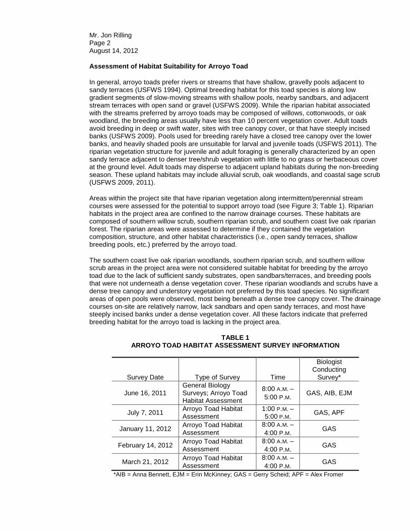
Mr. Jon Rilling Page 2 August 14, 2012
Assessment of Habitat Suitability for Arroyo Toad
In general, arroyo toads prefer rivers or streams that have shallow, gravelly pools adjacent to sandy terraces (USFWS 1994). Optimal breeding habitat for this toad species is along low gradient segments of slow-moving streams with shallow pools, nearby sandbars, and adjacent stream terraces with open sand or gravel (USFWS 2009). While the riparian habitat associated with the streams preferred by arroyo toads may be composed of willows, cottonwoods, or oak woodland, the breeding areas usually have less than 10 percent vegetation cover. Adult toads avoid breeding in deep or swift water, sites with tree canopy cover, or that have steeply incised banks (USFWS 2009). Pools used for breeding rarely have a closed tree canopy over the lower banks, and heavily shaded pools are unsuitable for larval and juvenile toads (USFWS 2011). The riparian vegetation structure for juvenile and adult foraging is generally characterized by an open sandy terrace adjacent to denser tree/shrub vegetation with little to no grass or herbaceous cover at the ground level. Adult toads may disperse to adjacent upland habitats during the non-breeding season. These upland habitats may include alluvial scrub, oak woodlands, and coastal sage scrub (USFWS 2009, 2011).
Areas within the project site that have riparian vegetation along intermittent/perennial stream courses were assessed for the potential to support arroyo toad (see Figure 3; Table 1). Riparian habitats in the project area are confined to the narrow drainage courses. These habitats are composed of southern willow scrub, southern riparian scrub, and southern coast live oak riparian forest. The riparian areas were assessed to determine if they contained the vegetation composition, structure, and other habitat characteristics (i.e., open sandy terraces, shallow breeding pools, etc.) preferred by the arroyo toad.
The southern coast live oak riparian woodlands, southern riparian scrub, and southern willow scrub areas in the project area were not considered suitable habitat for breeding by the arroyo toad due to the lack of sufficient sandy substrates, open sandbars/terraces, and breeding pools that were not underneath a dense vegetation cover. These riparian woodlands and scrubs have a dense tree canopy and understory vegetation not preferred by this toad species. No significant areas of open pools were observed, most being beneath a dense tree canopy cover. The drainage courses on-site are relatively narrow, lack sandbars and open sandy terraces, and most have steeply incised banks under a dense vegetation cover. All these factors indicate that preferred breeding habitat for the arroyo toad is lacking in the project area.
TABLE 1 ARROYO TOAD HABITAT ASSESSMENT SURVEY INFORMATION
Survey Date Type of Survey Time
Biologist Conducting
Survey*
June 16, 2011 General Biology Surveys; Arroyo Toad Habitat Assessment
8:00 A.M. – 5:00 P.M. GAS, AIB, EJM
July 7, 2011 Arroyo Toad Habitat Assessment
1:00 P.M. – 5:00 P.M. GAS, APF
January 11, 2012 Arroyo Toad Habitat Assessment
8:00 A.M. – 4:00 P.M. GAS
February 14, 2012 Arroyo Toad Habitat Assessment
8:00 A.M. – 4:00 P.M. GAS
March 21, 2012 Arroyo Toad Habitat Assessment
8:00 A.M. – 4:00 P.M. GAS
*AIB = Anna Bennett, EJM = Erin McKinney; GAS = Gerry Scheid; APF = Alex Fromer
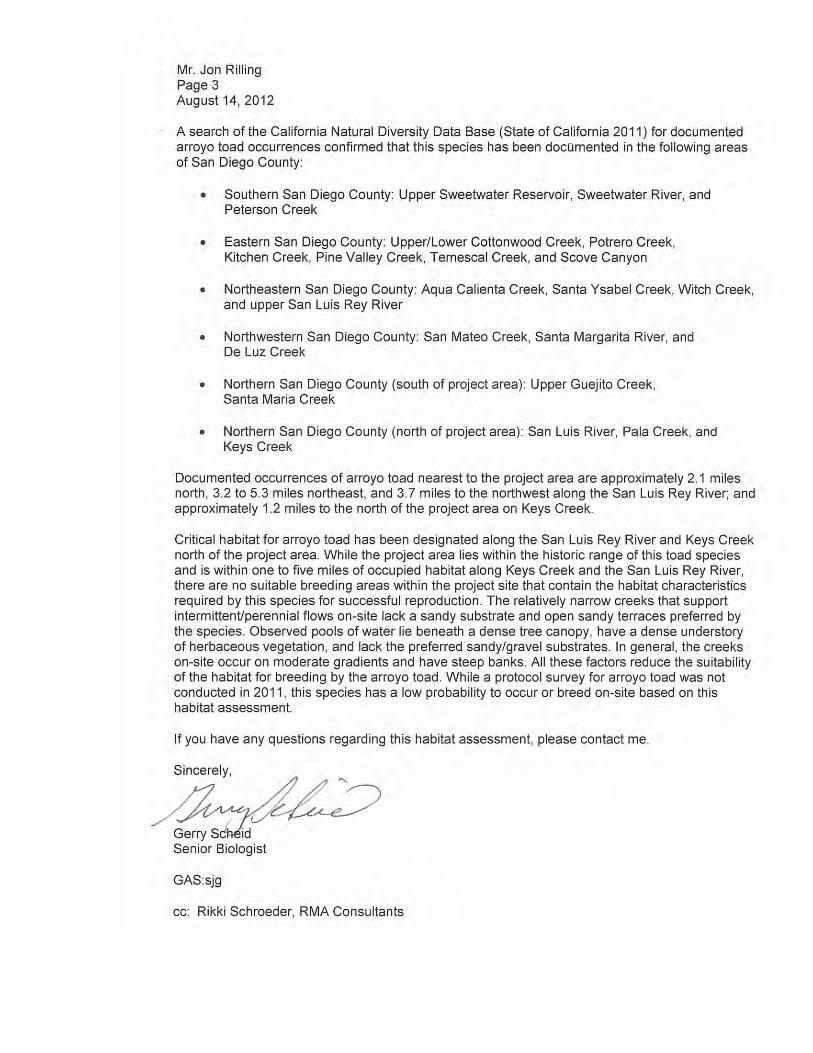

Mr. Jon Rilling Page 4 August 14, 2012
References Cited California, State of 2011 California Natural Diversity Database: Electronic Database with Annual Updates.
Wildlife & Habitat Data Analysis Branch, Department of Fish and Game. U.S. Fish and Wildlife Service (USFWS) 1994 Endangered and Threatened Wildlife and Plants; Determination of Endangered Status
for the Arroyo Southwestern Toad. Federal Register 59:241:64859-64866. 2009 Endangered and Threatened Wildfire and Plants; Revised Critical Habitat for the
Arroyo Toad (Anaxyrus californicus). Federal Register 74:196:52612-52664. 2011 Endangered and Threatened Wildfire and Plants; Revised Critical Habitat for the
Arroyo Toad. Federal Register 76:27:7246-7467. RECON Environmental, Inc. 2012 Biological Resource Report for the I-15/395 Master Planned Community MAP (Case #
3992-10-025).
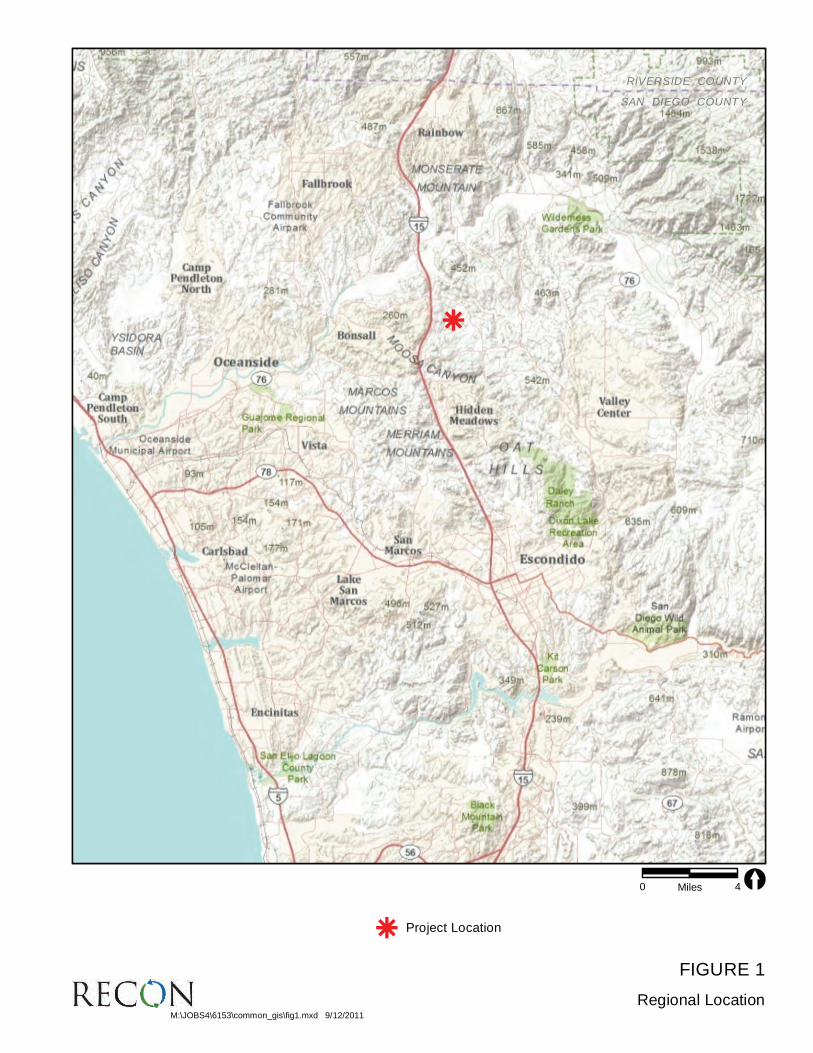
FIGURE 1
Regional Location
RIVERSIDE COUNTY
SAN DIEGO COUNTY
RIVERSIDE COUNTY
SAN DIEGO COUNTY
0 4Miles [
M:\JOBS4\6153\common_gis\fig1.mxd 9/12/2011
Project Locationk
k

FIGURE 2
Project Location on USGS Map
Map Source: USGS 7.5 minute topographic map series, Pala & Bonsall quadrangles, T10SR02W & T10SR03W
0 2,000Feet [
Project Boundary
Off-site Improvement Areas
M:\JOBS4\6153\common_gis\fig2.mxd 8/23/2012 fmm

FIGURE 3
Vegetation Communities, Land Cover Types, and
Arroyo Toad Habitat Assessment Areas
WE
ST
LIL
AC
RO
AD
N E L S O N W A Y
C O V E Y L A N E
SH
IR
E
YR
OA
D
LIL
AC
W
AL
K
R O D R I G U E Z R O A D
N U T B Y L A NE
ST
AN
DE
LL
AN
E
RO
CK
I N
GH
OR
SE
RO
AD
LIL
AC
PL
AC
E
RI T S O N R O A D
J A YJ A Y W A Y
MO
UN
TA
IN
R
ID
GE
R
OA
D
A N S E L W A Y
WE
ST
LIL
AC
RO
AD
N E L S O N W A Y
C O V E Y L A N E
SH
IR
E
YR
OA
D
LIL
AC
W
AL
K
R O D R I G U E Z R O A D
N U T B Y L A NE
ST
AN
DE
LL
AN
E
RO
CK
I N
GH
OR
SE
RO
AD
LIL
AC
PL
AC
E
RI T S O N R O A D
J A YJ A Y W A Y
MO
UN
TA
IN
R
ID
GE
R
OA
D
A N S E L W A Y
M:\JOBS4\6153\common_gis\fig3_artoHA.mxd 8/23/2012 fmm
0 800Feet [Project Boundary
Arroyo Toad Habitat Assessment Areas
Vegetation Communities and Landcover Type
Coastal Sage Scrub (32520)
Disturbed Coastal Sage Scrub (32520)
Coast Live Oak Woodland (71160)
Coastal/Valley Freshwater Marsh (52410)
Disturbed Coastal/Valley Freshwater Marsh (52410)
Disturbed Wetland (11200)
Eucalyptus Woodland (79100)
Mule Fat Scrub (63310)
Non-native Grassland (42200)
Southern Coast Live Oak Riparian Woodland (61310)
Disturbed Southern Coast Live Oak Riparian Woodland (61310)
Southern Mixed Chaparral (37120)
Disturbed Southern Mixed Chaparral (37120)
Southern Sycamore Riparian Woodland (62400)
Southern Willow Riparian Woodland (62500)
Southern Willow Scrub (63320)
Disturbed Southern Willow Scrub (63320)
Open Water - Fresh Water Agriculture Pond (64140)
Extensive Agriculture - Row Crops (18320)
Intensive Agriculture - Nursery (18200)
Orchard (18100)
Vinyard (18100)
Disturbed Habitat (11300)
Developed (12000)

ATTACHMENT 7
Plant Species Observed on Lilac Hills Ranch

THIS PAGE IS INTENTIONALLY BLANK.
Page 1
ATTACHMENT 7 PLANT SPECIES OBSERVED ON LILAC HILLS RANCH
Scientific Name Common Name Habitat Origin
LYCOPODS SELAGINELLACEAE SPIKE-MOSS FAMILY Selaginella bigelovii L. Underw. Bigelow spike-moss CSS, MC N
GYMNOSPERMS PINACEAE PINE FAMILY Pinus sp. pine OW, H I
ANGIOSPERMS: MAGNOLIIDS-PIPERALES SAURURACEAE LIZARD’S TAIL FAMILY Anemopsis californica (Nutt.) Hook. & Arn. yerba mansa RW, M N
ANGIOSPERMS: MONOCOTS AGAVACEAE AGAVE FAMILY Agave americana L. century plant H I Chlorogalum parviflorum S. Watson smallflower soap plant CSS, MC N Yucca schidigera Ortgies Mohave yucca MC N Yucca whipplei Torr. our Lord’s candle MC N ARACEAE ARUM FAMILY Lemna minor L. common duckweed RW, FM. M N ARECACEAE PALM FAMILY Phoenix dactylifera L. date palm RW, OW, H I Washingtonia robusta H. Wendl. Washington fan palm RW, OW, H I ASPHODELACEAE ASPHODEL FAMILY Asphodelus fistulosus L. Hollow-stem asphodel AG, O I CYPERACEAE SEDGE FAMILY Carex spissa L.H. Bailey San Diego sedge RW, M N Cyperus eragrostis Lam. tall flatsedge RW, M N Cyperus esculentus L. nut-grass, chufa RW, M N Schoenoplectus [=Scirpus] americanus (Pers.) Volkart ex Schinz &
R. Keller three-square FM, RW, M N
JUNCACEAE RUSH FAMILY Juncus acutus L. ssp. leopoldii (Parl.) Snogerup spiny rush RW, M N

ATTACHMENT 7 PLANT SPECIES OBSERVED ON LILAC HILLS RANCH
(continued)
Page 2
Scientific Name Common Name Habitat Origin Juncus dubius Engelm. Mariposa rush RW, M N Juncus mexicanus Willd. [=Juncus arcticus var. mexicanus] Mexican rush RW, M N Juncus xiphioides E. Meyer sword-leaved rush RW, M N LILIACEAE LILY FAMILY Calochortus splendens Benth. lilac mariposa MC N Calochortus weedii A.W. Wood var. weedii weed mariposa MC N POACEAE (GRAMINEAE) GRASS FAMILY Arundo donax L. giant reed RW I Avena barbata Link slender wild oat NNG, AG, O I Bromus carinatus Hook. & Arn. California brome NNG, AG, O N Bromus diandrus Roth ripgut grass NNG, AG, O I Bromus hordeaceus L. soft chess NNG, O I Bromus madritensis L. ssp. rubens (L.) Husnot red brome NNG, AG, O I Cortaderia selloana (Schult. & Schult. f.) Asch. & Graebn. pampas grass RW, OW I Cynodon dactylon (L.) Pers. Bermuda grass AG, O, H I Digitaria sanguinalis (L.) Scop. crabgrass AG, O I Echinochloa crus-galli (L.) P. Beauv. barnyard grass NNG, MC, RW I Gastridium ventricosum (Gouan) Schinz & Thell. nit grass MC I Hordeum murinum L. wild barley NNG, AG, O I Lamarckia aurea (L.) Moench goldentop AG, O I Leptochloa uninervia (J. Presl) Hitchc. & Chase Mexican sprangletop RW N Leymus condensatus (C. Presl) Á. Löve giant rye grass RW N Lolium perenne L. perennial ryegrass NNG, AG, O I Melica imperfecta Trin. California melic MC, RW N Muhlenbergia rigens (Benth.) Hitchc. deergrass RW N Nassella cernua (Stebbins & Love) Barkworth nodding needlegrass CSS, MC N Nassella lepida (Hitchc.) Barkworth foothill needlegrass CSS, MC N Nassella pulchra (Hitchc.) Barkworth purple needlegrass CSS, MC N Paspalum dilatatum Poir. dallis grass AG, O I Pennisetum setaceum (Forssk.) Chiov. fountain grass RW, OW I Poa pratensis L. ssp. pratensis Kentucky bluegrass O, H I Poa secunda J. Presl ssp. secunda one-sided bluegrass MC N Polypogon monspeliensis (L.) Desf. annual beard grass RW, M I Vulpia myuros (L.) C.C. Gmel var. myuros rattail fescue NNG, O, AG I
ATTACHMENT 7 PLANT SPECIES OBSERVED ON LILAC HILLS RANCH
(continued)
Page 3
Scientific Name Common Name Habitat Origin THEMIDACEAE BRODIAEA FAMILY Dichelostemma capitatum (Benth.) A.W. Wood blue dicks CSS, MC N TYPHACEAE CATTAIL FAMILY Typha latifolia L. broad-leaved cattail FM, M N
ANGIOSPERMS: DICOTS ADOXACEAE ADOXA FAMILY Sambucus nigra [=mexicana] L. ssp. caerulea (Raf.) Bolli blue elderberry RW N AIZOACEAE FIG-MARIGOLD FAMILY Carpobrotus chilensis (Molina) N.E. Br. sea fig RW, O, H I Carpobrotus edulis (L.) N.E. Br. hottentot fig RW, O , H I Mesembryanthemum crystallinum L. crystalline ice plant O, H I Mesembryanthemum nodiflorum L. slender-leaved ice plant O, H I AMARANTHACEAE AMARANTH FAMILY Amaranthus albus L. tumbleweed AG, O I Amaranthus californicus (Moq.) S. Watson California amaranth RW, MC N ANACARDIACEAE SUMAC OR CASHEW FAMILY Malosma laurina Nutt. ex Abrams laurel sumac CSS, MC N Rhus ovata S. Watson sugar bush CSS, MC, RW N Schinus molle L. Peruvian pepper tree AG, O, H I Schinus terebinthifolius Raddi Brazilian pepper tree AG, O, H I Toxicodendron diversilobum (Torr. & A. Gray) Greene western poison oak RW, OW N APIACEAE (UMBELLIFERAE) CARROT FAMILY Apiastrum angustifolium Nutt. wild-celery RW N Apium graveolens L. celery RW I Conium maculatum L. poison hemlock RW, M I Daucus pusillus Michx. rattlesnake weed MC N Foeniculum vulgare Mill. fennel AG, O I Lomatium dasycarpum (Torr. & A. Gray) J.M. Coult. & Rose
ssp. dasycarpum lace parsnip MC N
Sanicula arguta J.M. Coult. & Rose little-jim sanicle MC N APOCYNACEAE DOGBANE FAMILY Nerium oleander L. oleander AG, H I

ATTACHMENT 7 PLANT SPECIES OBSERVED ON LILAC HILLS RANCH
(continued)
Page 4
Scientific Name Common Name Habitat Origin ASTERACEAE SUNFLOWER FAMILY Acourtia microcephala DC. purple-head, sacapellote RW, MC N Ambrosia psilostachya DC. western ragweed RW, M N Artemisia californica Less. California sagebrush CSS, MC N Artemisia douglasiana Besser mugwort RW N Baccharis emoryi A. Gray chaparral broom RW N Baccharis pilularis DC. coyote brush OW, MC, CSS N Baccharis salicifolia (Ruiz & Pav.) Pers. mule fat, seep-willow RW N Baccharis sarothroides A. Gray broom baccharis MC, O N Brickellia californica (Torr. & A. Gray) A. Gray California brickellbush MC N Carduus pycnocephalus L. Italian thistle CSS, MC, AG, O,
RW I
Centaurea melitensis L. tecalote, star-thistle NNG, AG, O I Chaenactis artemisiifolia (Harv. & A. Gray) A. Gray white pincushion MC N Chaenactis glabriuscula DC. yellow pincushion MC N Cirsium occidentale (Nutt.) Jeps. var. occidentale cobwebby thistle RW N Cirsium vulgare (Savi) Ten. bull thistle RW, O I Conyza bonariensis (L.) Cronquist flax-leaf fleabane RW, AG, O I Conyza canadensis (L.) Cronquist horseweed RW, AG, O N Corethrogyne filaginifolia [= all previously known Lessingia filaginifolia
varieties in California] (Hook. & Arn.) Nutt. California-aster MC N
Cynara scolymus L. artichoke AG, O, H I Deinandra [=Hemizonia] fasciculata (DC.) Greene golden tarplant CSS, MC N Dimorphotheca pluvialis (L.) Moench African daisy AG, O, H I Encelia farinosa A. Gray ex Torr. brittlebush, incienso MC N Eriophyllum confertiflorum (DC.) A. Gray var. confertiflorum golden-yarrow MC, CSS N Gazania linearis (Thunb.) Druce treasure flower AG, H I Gnaphalium californicum DC. green everlasting MC N Gnaphalium luteoalbum L. everlasting MC I Gnaphalium stramineum Kunth cotton-batting plant MC N Hazardia squarrosa (Hook. & Arn.) Greene saw-toothed goldenbush MC N Helminthotheca [=Picris] echioides (L.) Holub bristly ox-tongue RW, M I Heterotheca grandiflora Nutt. telegraph weed NNG, O N Holocarpha virgata (A. Gray) D.D. Keck ssp. elongata D.D. Keck graceful tarplant MC N Hypochaeris glabra L. smooth cat’s-ear CSS, MC, O I

ATTACHMENT 7 PLANT SPECIES OBSERVED ON LILAC HILLS RANCH
(continued)
Page 5
Scientific Name Common Name Habitat Origin Isocoma menziesii (Hook. & Arn.) G.L. Nesom coast goldenbush MC N Lactuca serriola L. prickly lettuce RW, M I Logfia filaginoides [=Filago californica] (Hook. & Arn.) Morefield California herba impia, fluffweed CSS, MC, O N Osmadenia tenella Nutt. osmadenia MC, CSS N Pluchea odorata (L.) Cass. salt marsh fleabane RW, M N Pseudognaphalium beneolens [=Gnaphalium canescens
ssp. beneolens] (Davidson) Anderb. fragrant everlasting MC N
Pseudognaphalium canescens [=Gnaphalium canescens ssp. canescens] (DC.) Anderb.
everlasting cudweed MC N
Pseudognaphalium microcephalum [=Gnaphalium canescens ssp. microcephalum] (Nutt.) Anderb.
white everlasting MC N
Psilocarphus tenellus Nutt. slender woolly marbles MC N Senecio vulgaris L. common groundsel O, AG I Sonchus asper (L.) Hill ssp. asper prickly sow thistle RW, O I Sonchus oleraceus L. common sow thistle RW, O I Stephanomeria virgata Benth. slender stephanomeria MC N Stylocline gnaphaloides Nutt. everlasting nest straw MC N BORAGINACEAE BORAGE FAMILY Cryptantha intermedia (A. Gray) Greene nievitas cryptantha CSS, MC N Cryptantha micromeres (A. Gray) Greene minute-flower cryptantha CSS, MC N Eucrypta chrysanthemifolia (Benth.) Greene eucrypta MC N Pectocarya linearis (Ruiz & Pav.) DC. ssp. ferocula (I.M. Johnst.) Thorne comb-bur MC N Phacelia distans Benth. wild-heliotrope CSS, MC N Phacelia grandiflora (Benth.) A. Gray large-flowered phacelia MC, RW N Phacelia parryi Torr. Parry phacelia MC N BRASSICACEAE (CRUCIFERAE) MUSTARD FAMILY Brassica nigra (L.) W.D.J. Koch black mustard NNG, AG, O I Hirschfeldia incana (L.) Lagr.-Fossat short-pod mustard NNG, AG, O I Lepidium lasiocarpum Nutt. var. lasiocarpum sand peppergrass MC N Nasturtium officinale [=Rorippa nasturtium-aquaticum] R. Br. water cress RW, M I Raphanus sativus L. radish AG, O I Sisymbrium officinale L. hedge mustard AG, O I Sisymbrium orientale L. mustard AG, O I

ATTACHMENT 7 PLANT SPECIES OBSERVED ON LILAC HILLS RANCH
(continued)
Page 6
Scientific Name Common Name Habitat Origin CACTACEAE CACTUS FAMILY Opuntia ficus-indica (L.) Mill. Indian fig AG, MC, O I Opuntia littoralis (Engelm.) Cockerell. shore cactus MC N CAPRIFOLIACEAE HONEYSUCKLE FAMILY Lonicera subspicata Hook. & Arn. southern honeysuckle MC N CARYOPHYLLACEAE PINK FAMILY Silene gallica L. windmill pink MC I Spergula arvensis L. stickwort, starwort MC, O I CHENOPODIACEAE GOOSEFOOT FAMILY Atriplex semibaccata R. Br. Australian saltbush O I Chenopodium album L. lamb’s quarters, pigweed AG, O I Chenopodium californicum (S. Watson) S. Watson California pigweed MC N Chenopodium murale L. nettle-leaved goosefoot AG, O I Dysphania [=Chenopodium] ambrosioides (L.) Mosyakin & Clemants Mexican tea AG, O I Salsola tragus L. Russian thistle, tumbleweed AG, O I CISTACEAE ROCK-ROSE FAMILY Helianthemum scoparium Nutt. peak rush-rose MC N CONVOLVULACEAE MORNING-GLORY FAMILY Calystegia macrostegia (Greene) Brummitt ssp. intermedia (Abrams)
Brummitt chaparral morning-glory CSS, MC N
Convolvulus arvensis L. bindweed, orchard morning-glory CSS, MC I Cuscuta californica Hook. & Arn. dodder CSS, MC N Ipomoea purpurea (L.) Roth. common morning-glory H I CRASSULACEAE STONECROP FAMILY Dudleya pulverulenta (Nutt.) Britton & Rose chalk lettuce, chalk dudleya CSS, MC RW, OW N CUCURBITACEAE GOURD FAMILY Marah macrocarpus (Greene) Greene wild cucumber CSS, MC N ERICACEAE HEATH FAMILY Xylococcus bicolor Nutt. mission manzanita MC N EUPHORBIACEAE SPURGE FAMILY Chamaesyce sp. prostrate spurge CSS, MC, O N Croton [=Eremocarpus] setigerus Hook. dove weed AG, O N

ATTACHMENT 7 PLANT SPECIES OBSERVED ON LILAC HILLS RANCH
(continued)
Page 7
Scientific Name Common Name Habitat Origin Ricinus communis L. castor bean RW, M I FABACEAE (LEGUMINOSAE) LEGUME FAMILY Acmispon glaber (Vogel) Brouillet [=Lotus scoparius] deerweed CSS, MC N Acmispon micranthus (Torr. & A. Gray) Brouillet [=Lotus hamatus] grab lotus MC N Lupinus bicolor Lindl. miniature lupine MC N Lupinus truncatus Nutt. chaparral lupine MC N Melilotus indicus (L.) All. sourclover AG, O, M I FAGACEAE OAK FAMILY Quercus agrifolia Née coast live oak, encina RW, OW N Quercus berberidifolia Liebm. scrub oak RW N Quercus engelmannii Greene Engelmann oak, mesa oak RW, OW N GENTIANACEAE GENTIAN FAMILY Zeltnera [=Centaurium] venusta (A. Gray) G. Mans. canchalagua MC N GERANIACEAE GERANIUM FAMILY Erodium cicutarium (L.) L’Hér. ex Aiton red stemmed filaree AG, O I Pelargonium x hortorum L.H. Bailey garden geranium AG, H I LAMIACEAE MINT FAMILY Marrubium vulgare L. horehound AG, O , MC I Salvia columbariae Benth. chia MC N Salvia mellifera Greene black sage CSS, MC N Stachys ajugoides Benth. var. rigida (Nutt. ex Benth.) Jeps. & Hoover hedge nettle RW, OW N LYTHRACEAE LOOSESTRIFE FAMILY Lythrum hyssopifolia L. grass poly, hyssop loosestrife RW, M I MALVACEAE MALLOW FAMILY Malacothamnus fasciculatus (Nutt. ex Torr. & A. Gray) Greene chaparral mallow MC N Malva parviflora L. cheeseweed, little mallow AG, O I Malvella leprosa (Ortega) Krapov. alkali-mallow, white-weed RW, M N MONTIACEAE MONTIA FAMILY Calandrinia ciliata (Ruiz & Pav.) DC. red maids MC N Claytonia perfoliata Willd. miner’s lettuce MC, CSS, RW, OW N MYRTACEAE MYRTLE FAMILY Eucalyptus sp. gum tree AG, H I

ATTACHMENT 7 PLANT SPECIES OBSERVED ON LILAC HILLS RANCH
(continued)
Page 8
Scientific Name Common Name Habitat Origin MYRSINACEAE Anagallis arvensis L. scarlet pimpernel, poor-man’s
weatherglass AG, O I
NYCTAGINACEAE FOUR O’CLOCK FAMILY Mirabilis laevis [=californica] (Benth.) Curran var. crassifolia (Choisy)
Spellenb. wishbone bush MC N
OLEACEAE OLIVE FAMILY Olea europaea L. olive AG, O, H I ONAGRACEAE EVENING-PRIMROSE FAMILY Camissonia bistorta (Torr. & A. Gray) P.H. Raven California sun cup MC N Clarkia purpurea (Curtis) A. Nelson & J.F. Macbr. ssp. quadrivulnera
(Douglas ex Lindl.) H. Lewis & M. Lewis four-spot MC N
Epilobium ciliatum Raf. ssp. ciliatum sticky willowweed RW, M N PAEONIACEAE PEONY FAMILY Paeonia californica Nutt. California peony MC N PAPAVERACEAE POPPY FAMILY Ehrendorferia [=Dicentra] chrysantha (Hook. & Arn.) Rylander golden ear-drops MC N Eschscholzia californica Cham. California poppy MC N PHRYMACEAE [=SCROPHULARIACEAE] HOPSEED FAMILY Mimulus aurantiacus Curtis low bush monkey-flower MC, CSS N Mimulus guttatus DC. common monkey-flower RW, M N PLANTAGINACEAE PLANTAIN FAMILY Antirrhinum nuttallianum Benth. ex A. DC. Nuttall snapdragon CSS, MC N Keckiella antirrhinoides (Benth.) Straw var. antirrhinoides yellow bush penstemon MC N Plantago erecta E. Morris dot-seed plantain CSS N Plantago major L. common plantain AG, O, H I PLATANACEAE PLANE TREE OR SYCAMORE FAMILY Platanus racemosa Nutt. western sycamore RW N POLEMONIACEAE PHLOX FAMILY Gilia sp. gilia MC N Navarretia hamata Greene hooked navarretia MC N

ATTACHMENT 7 PLANT SPECIES OBSERVED ON LILAC HILLS RANCH
(continued)
Page 9
Scientific Name Common Name Habitat Origin POLYGONACEAE BUCKWHEAT FAMILY Chorizanthe fimbriata Nutt. fringed spineflower MC N Chorizanthe procumbens Nutt. prostrate spineflower MC N Eriogonum fasciculatum Benth. var. fasciculatum coast California buckwheat CSS, MC N Persicaria [=Polygonum] lapathifolium (L.) Gray willow weed RW, M N Polygonum aviculare L. ssp. depressum [=P. arenastrum] (Meisn.)
Arcangeli common knotweed, doorweed AG, O I
Pterostegia drymarioides Fisch. & C.A. Mey. California thread-stem CSS, MC N Rumex crispus L. curly dock RW, M, AG I PORTULACACEAE PURSLANE FAMILY Portulaca oleracea L. purslane AG, O I RANUNCULACEAE BUTTERCUP FAMILY Clematis pauciflora Nutt. ropevine CSS, MC, RW N RESEDACEAE MIGNONETTE FAMILY Reseda odorata L. garden mignonette RW I RHAMNACEAE BUCKTHORN FAMILY Ceanothus crassifolius Torr. hoaryleaf ceanothus MC N Ceanothus oliganthus Nutt. hairy ceanothus MC N Ceanothus tomentosus Parry coast blue lilac MC N Rhamnus crocea Nutt. spiny redberry MC N ROSACEAE ROSE FAMILY Adenostoma fasciculatum Hook. & Arn. chamise MC N Heteromeles arbutifolia (Lindl.) M. Roem. toyon, Christmas berry MC, RW N RUBIACEAE MADDER OR COFFEE FAMILY Galium angustifolium A. Gray ssp. angustifolium narrow-leaf bedstraw MC, CSS N Galium aparine L. goose grass, stickywilly MC, CSS N Galium nuttallii A. Gray San Diego bedstraw MC N RUTACEAE RUE OR CITRUS FAMILY Cneoridium dumosum (Nutt. ex Torr. & A. Gray) Baill. bushrue MC N SALICACEAE WILLOW FAMILY Populus fremontii S. Watson ssp. fremontii Fremont cottonwood, alamo RW N Salix exigua Nutt. narrow-leaved willow RW N

ATTACHMENT 7 PLANT SPECIES OBSERVED ON LILAC HILLS RANCH
(continued)
Page 10
Scientific Name Common Name Habitat Origin Salix gooddingii C.R. Ball. Goodding’s black willow RW N Salix laevigata Bebb red willow RW N Salix lasiolepis Benth. arroyo willow RW N SCROPHULARIACEAE FIGWORT FAMILY Cordylanthus rigidus (Benth.) Jeps. ssp. setigerus T.I. Chuang &
Heckard thread-leaved bird’s-beak MC N
Scrophularia californica Cham. & Schltdl. California figwort MC N SOLANACEAE NIGHTSHADE FAMILY Datura wrightii Regel Jimson weed, thorn-apple, tolguacha AG, O, MC N Nicotiana glauca Graham tree tobacco AG, O, RW I Solanum americanum Mill. white nightshade MC, AG, O N Solanum xanti [=tenuilobatum] A. Gray chaparral nightshade MC, AG, O N TAMARICACEAE TAMARISK FAMILY Tamarix ramosissima Ledeb. saltcedar RW, M I URTICACEAE NETTLE FAMILY Urtica urens L. dwarf nettle RW, M, AG, O I VERBENACEAE VERVAIN FAMILY Verbena lasiostachys Link western vervain RW, M N VITACEAE GRAPE FAMILY Vitis girdiana Munson desert wild grape RW, OW N Vitis vinifera L. cultivated grape, wine grape AG I ZYGOPHYLLACEAE CALTROP FAMILY Tribulus terrestris L. puncture vine AG, O I SOURCES: Jepson Online Interchange <http://ucjeps.berkeley.edu/interchange.html> (2009); K.N. Brenzel (editor), Sunset Western Garden Book (Sunset Publishing, Menlo Park, CA, 2001); John P. Rebman and Michael G. Simpson, Checklist of the Vascular Plants of San Diego County, 4th ed. (San Diego Natural History Museum, San Diego, CA, 2006); Natural Resources Conservation Service Plants Database <http://plants.usda.gov/> (USDA 2008).

ATTACHMENT 7 PLANT SPECIES OBSERVED ON LILAC HILLS RANCH
(continued)
Page 11
HABITATS ORIGIN AG = Agriculture N = Native to locality CSS = Coastal sage scrub I = Introduced species from outside locality FM = Freshwater marsh H = Horticultural M = Mesic areas and wetlands MC = Southern mixed chaparral NNG = Non-native grassland O = Open places, waste places, roadsides, burns, etc. OW = Oak woodland RW = Riparian woodland

ATTACHMENT 7 PLANT SPECIES OBSERVED ON LILAC HILLS RANCH
(continued)
Page 12
‘THIS PAGE IS INTENTIONALLY BLANK.

ATTACHMENT 8
Wildlife Species Observed/Detected on Lilac Hills Ranch

THIS PAGE IS INTENTIONALLY BLANK.

Page 1
ATTACHMENT 8 WILDLIFE SPECIES OBSERVED/DETECTED ON LILAC HILLS RANCH
Scientific Name
Common Name
Occupied Habitat
On-site Abundance/ Seasonality (Birds Only)
Evidence of
Occurrence
INVERTEBRATES (Nomenclature from Eriksen and Belk 1999; Milne and Milne 1980; Mattoni 1990; and Opler and Wright 1999)
HESPERIIDAE SKIPPERS Erynnis funeralis funereal duskywing RW F O Pyrgus communis common checkered skipper CSS C O
PAPILIONIDAE PARNASSIANS & SWALLOWTAILS Papilio rutulus western tiger swallowtail RW F O
PIERIDAE WHITES & SULPHURS Anthocharis sara Sara or Pacific orangetip CSS, MC F O Pontia protodice common or checkered white CSS, MC, O C O Pieris rapae cabbage white CSS, MC, O C O
LYCAENIDAE BLUES, COPPERS, & HAIRSTREAKS Callophrys augustinus iroides brown elfin MC F O Glaucopsyche lygdamus australis southern or silvery blue CSS, MC F O Icaricia acmon acmon Acmon blue CSS, MC C O Strymon melinus pudica common or gray hairstreak MC F O
RIODINIDAE METALMARKS Apodemia virgulti Behr’s metalmark CSS, MC C O
NYMPHALIDAE BRUSH-FOOTED BUTTERFLIES Limenitis lorquini lorquini Lorquin’s admiral RW F O Coenonympha tullia california California or common ringlet CSS, MC, O C O Junonia coenia common buckeye CSS, MC C O Nymphalis antiopa antiopa mourning cloak CSS, MC, RW F O Vanessa annabella west coast lady CSS, MC C O Vanessa atalanta rubria red admiral RW F O Vanessa cardui painted lady CSS, MC C O

ATTACHMENT 8 WILDLIFE SPECIES OBSERVED/DETECTED ON LILAC HILLS RANCH
(continued)
Page 2
Scientific Name
Common Name
Occupied Habitat
On-site Abundance/ Seasonality (Birds Only)
Evidence of
Occurrence
AMPHIBIANS (Nomenclature from Crother 2001 and Crother et al. 2003)
HYLIDAE TREE FROGS Pseudacris cadaverina California treefrog RW, M, FM C V Pseudacris regilla Pacific treefrog RW, M, FM C V
RANIDAE TRUE FROGS Lithobates catesbeiana American bullfrog RW, M, FM F O, V
REPTILES (Nomenclature from Crother 2001 and Crother et al. 2003)
IGUANIDAE IGUANID LIZARDS Phrynosoma coronatum (San Diego/blainvillii pop.)
coast horned lizard O U O
Sceloporus occidentalis western fence lizard CSS, MC, AG, O C O Sceloporus orcutti granite spiny lizard CSS, MC, O F O Uta stansburiana common side-blotched lizard CSS, MC C O
TEIIDAE WHIPTAIL LIZARDS Aspidoscelis hyperythra beldingi Belding’s orange-throated whiptail CSS, RW U O Aspidoscelis tigris stejnegeri Coastal whiptail O U O
CROTALIDAE RATTLESNAKES Crotalus ruber red diamond rattlesnake O, MC U Crotalus oreganus helleri southern Pacific rattlesnake MC F O
BIRDS (Nomenclature from American Ornithologists’ Union 1998 and Unitt 2004)
ANATIDAE DUCKS, GEESE, & SWANS Anas platyrhynchos platyrhynchos mallard RW, M U / Y O
ODONTOPHORIDAE NEW WORLD QUAIL Callipepla californica californica California quail CSS, MC C / Y O, V

ATTACHMENT 8 WILDLIFE SPECIES OBSERVED/DETECTED ON LILAC HILLS RANCH
(continued)
Page 3
Scientific Name
Common Name
Occupied Habitat
On-site Abundance/ Seasonality (Birds Only)
Evidence of
Occurrence
ARDEIDAE HERONS & BITTERNS Egretta thula thula snowy egret RW, M U / W O
CATHARTIDAE NEW WORLD VULTURES Cathartes aura turkey vulture F F/ M, S O
ACCIPITRIDAE HAWKS, KITES, & EAGLES Accipiter cooperii Cooper’s hawk RW, W, CSS F / Y O, V Buteo jamaicensis red-tailed hawk F C / Y O, V Buteo lineatus elegans red-shouldered hawk F C / Y O, V Elanus leucurus white-tailed kite RW,M U / Y O, V
FALCONIDAE FALCONS & CARACARAS Falco sparverius sparverius American kestrel AG, MC F / Y O
CHARADRIIDAE LAPWINGS & PLOVERS Charadrius vociferus vociferus killdeer RW, M U / Y O
COLUMBIDAE PIGEONS & DOVES Streptopeleia decaocto Eurasian collared dove W U / Y O Zenaida macroura marginella mourning dove CSS, MC, O, AG, W C / Y O, V
CUCULIDAE CUCKOOS & ROADRUNNERS Geococcyx californianus greater roadrunner CSS, MC, O, AG F / Y O
STRIGIDAE TYPICAL OWLS Bubo virginianus great horned owl RW U/ Y O
APODIDAE SWIFTS Aeronautes saxatalis white-throated swift RW, M F / Y O
TROCHILIDAE HUMMINGBIRDS Archilochus alexandri black-chinned hummingbird CSS, MC F / S O, V Calypte anna Anna’s hummingbird CSS, MC, O, AG, W, RW C / Y O, V Calypte costae Costa’s hummingbird CSS, MC F/ S O,V

ATTACHMENT 8 WILDLIFE SPECIES OBSERVED/DETECTED ON LILAC HILLS RANCH
(continued)
Page 4
Scientific Name
Common Name
Occupied Habitat
On-site Abundance/ Seasonality (Birds Only)
Evidence of
Occurrence
PICIDAE WOODPECKERS & SAPSUCKERS Colaptes auratus northern flicker RW, M, W U / Y O, V
Melanerpes formicivorus bairdi acorn woodpecker W U / Y O,V Picoides nuttallii Nuttall’s woodpecker W, RW F / Y O, V Picoides pubescens turati downy woodpecker W, RW U / Y O, V
TYRANNIDAE TYRANT FLYCATCHERS Empidonax difficilis Pacific slope flycatcher RW, M, W U / S O Myiarchus cinerascens cinerascens ash-throated flycatcher RW, M, W U / S O Sayornis nigricans semiatra black phoebe CSS, MC, O, AG, W, RW C / Y O, V Sayornis saya Say’s phoebe CSS, MC, O, AG C / W O Tyrannus vociferans vociferans Cassin’s kingbird CSS, MC, O, AG, C / Y O
LANIIDAE SHRIKES Lanius ludovicianus loggerhead shrike AG U / Y O
VIREONIDAE VIREOS Vireo huttoni huttoni Hutton’s vireo RW,M U / Y O, V
CORVIDAE CROWS, JAYS, & MAGPIES Aphelocoma californica western scrub-jay CSS, MC, O, AG, W C / Y O, V Corvus brachyrhynchos hesperis American crow CSS, MC, O, AG, W, RW,
M, U C / Y O, V
Corvus corax clarionensis common raven CSS, MC, O, AG, W, RW, M, U
F / Y O, V
HIRUNDINIDAE SWALLOWS Petrochelidon pyrrhonota tachina cliff swallow RW, W, AG, M F / S O Stelgidopteryx serripennis northern rough-winged swallow RW, W, AG, M F / S O
PARIDAE CHICKADEES & TITMICE Baeolophus inornatus transpositus oak titmouse W U / Y O,V
AEGITHALIDAE BUSHTIT Psaltriparus minimus minimus bushtit CSS, MC, O, AG, W, RW C / Y O, V

ATTACHMENT 8 WILDLIFE SPECIES OBSERVED/DETECTED ON LILAC HILLS RANCH
(continued)
Page 5
Scientific Name
Common Name
Occupied Habitat
On-site Abundance/ Seasonality (Birds Only)
Evidence of
Occurrence
TROGLODYTIDAE WRENS Thryomanes bewickii Bewick’s wren CSS, MC, W, RW F / Y O, V Troglodytes aedon parkmanii house wren CSS, MC, O, AG, W, RW,M C / Y O, V
TURDIDAE THRUSHES Sialia mexicana occidentalis western bluebird AG U / W O
TIMALIIDAE BABBLERS Chamaea fasciata henshawi wrentit CSS, MC, O, AG, W, RW F / Y O, V
MIMIDAE MOCKINGBIRDS & THRASHERS Mimus polyglottos polyglottos northern mockingbird CSS, MC, AG, RW, M C / Y O, V Toxostoma redivivum redivivum California thrasher CSS, MC, W F / Y O, V
STURNIDAE STARLINGS & MYNAS Sturnus vulgaris European starling (I) O, U C / Y O, V
PTILOGONATIDAE SILKY FLYCATCHERS Phainopepla nitens lepida phainopepla CSS, MC, RW, M F / Y O, V
PARULIDAE WOOD WARBLERS Dendroica coronata yellow-rumped warbler CSS, MC F / W O, V Dendroica petechia yellow warbler RW, M U / S O, V Geothlypis trichas common yellowthroat RW, M F / Y O, V Icteria virens auricollis yellow-breasted chat RW, M F / Y O, V Vermivora celata orange-crowned warbler MC F / Y V
EMBERIZIDAE EMBERIZIDS Melospiza melodia song sparrow CSS, MC, O, AG, W, RW,M C / Y O, V Pipilo crissalis California towhee CSS, MC, O, AG, W C / Y O, V Pipilo maculatus spotted towhee CSS, RW, M C / Y O, V
CARDINALIDAE CARDINALS & GROSBEAKS Passerina caerulea salicaria blue grosbeak RW,M, W F / S O, V Pheucticus melanocephalus maculatus black-headed grosbeak RW,M, W F / S O, V

ATTACHMENT 8 WILDLIFE SPECIES OBSERVED/DETECTED ON LILAC HILLS RANCH
(continued)
Page 6
Scientific Name
Common Name
Occupied Habitat
On-site Abundance/ Seasonality (Birds Only)
Evidence of
Occurrence
ICTERIDAE BLACKBIRDS & NEW WORLD ORIOLES Icterus bullockii Bullock’s oriole CSS, MC, RW, M, W U / S O, V Icterus cucullatus nelsoni hooded oriole RW, M U / S O, V Molothrus ater brown-headed cowbird RW U / Y O
FRINGILLIDAE FINCHES Carduelis psaltria hesperophilus lesser goldfinch CSS, MC, RW, M C / Y O, V Carpodacus mexicanus frontalis house finch CSS, MC, RW, O, U C / Y O, V
MAMMALS (Nomenclature from Baker et al. 2003)
LEPORIDAE RABBITS & HARES Lepus californicus bennettii San Diego black-tailed jackrabbit CSS, AG U O Sylvilagus audubonii desert cottontail CSS, MC F O
SCIURIDAE SQUIRRELS & CHIPMUNKS Spermophilus beecheyi California ground squirrel CSS, MC, W, O, Ag F O
MURIDAE OLD WORLD MICE & RATS (I) Neotoma lepida intermedia San Diego desert woodrat CSS, MC, W F D
CANIDAE CANIDS Canis latrans coyote CSS,MC, O U O, S
PROCYONIDAE PROCYONIDS Procyon lotor northern raccoon RW U T
CERVIDAE DEER
Odocoileus hemionus mule deer MC U O, T
(I) = Introduced species

ATTACHMENT 8 WILDLIFE SPECIES OBSERVED/DETECTED ON LILAC HILLS RANCH
(continued)
Page 7
HABITATS ABUNDANCE (based on Garrett and Dunn 1981) Ag = Agriculture C = Common to abundant; almost always encountered in proper habitat, usually in moderate to MC = Mixed chaparral large numbers CSS = Coastal sage scrub F = Fairly common; usually encountered in proper habitat, generally not in large F = Flying overhead numbers FM = Freshwater marsh U = Uncommon; occurs in small numbers or only locally M = Mesic areas and wetlands O = Open places, waste places, roadsides, etc. SEASONALITY (birds only) RW = Riparian woodlands A = Accidental; species not known to occur under normal conditions; may be an off-course migrant U = Urban M = Migrant; uses site for brief periods of time, primarily during spring and fall months W = Woodlands S = Spring/summer resident; probable breeder on-site or in vicinity T = Transient; uses site regularly but unlikely to breed on-site V = Rare vagrant W = Winter visitor; does not breed locally Y = Year-round resident; probable breeder on-site or in vicinity . EVIDENCE OF OCCURRENCE B = Burrow C = Carcass/remains D = Den site O = Observed S = Scat T = Track V = Vocalization

ATTACHMENT 8 WILDLIFE SPECIES OBSERVED/DETECTED ON LILAC HILLS RANCH
(continued)
Page 8
THIS PAGE IS INTENTIONALLY BLANK.

ATTACHMENT 9
Sensitive Plant Species Observed or with the Potential to Occur on Lilac Hills Ranch

THIS PAGE IS INTENTIONALLY BLANK.

Page 1
ATTACHMENT 9 SENSITIVE PLANT SPECIES OBSERVED OR WITH THE POTENTIAL TO OCCUR ON LILAC HILLS RANCH
Scientific Name / Common Name
Sensitivity Code & Status* Federal/State
CNPS Rank County Sensitive
Plant List Habitat Preference /
Requirements Verified On-site /
Evidence Potential to Occur On-
site
Factual Basis for Determination of
Occurrence Potential Arctostaphylos rainbowensis Rainbow manzanita
---/--- CNPS Rank: 1B.1
County List A
Evergreen shrub; chaparral; rocky Cieneba, Las Posas soil, Pala; blooms Jan.–Feb; elevation 700–2,200 feet.
Not observed Low The project site is located just south of the known range for this species (Reiser 2001). Nearest known observations of this species are to the east of Keys Creek to the northwest of Valley Center. This shrub species would have been observed if present on-site.

ATTACHMENT 9 SENSITIVE PLANT SPECIES OBSERVED OR WITH THE POTENTIAL TO OCCUR ON LILAC HILLS RANCH
(continued)
Page 2
Scientific Name / Common Name
Sensitivity Code & Status* Federal/State
CNPS Rank County Sensitive
Plant List Habitat Preference /
Requirements Verified On-site /
Evidence Potential to Occur On-
site
Factual Basis for Determination of
Occurrence Potential Ambrosia pumila San Diego ambrosia
FE/--- CNPS Rank: 1B.1
County List A
Perennial herb; chaparral, coastal sage scrub, valley and foothill grassland, creek beds, vernal pools, often in disturbed areas; blooms May–Sept.; elevation less than 1,400 feet. Many occurrences extirpated in San Diego County.
Not observed Low Dense oak woodland habitats found on drainages on-site area not conducive to this species. The willow scrub habitat present in the southern portion of the site may have historically provided the best habitat on-site for this species; however, agricultural activities have disturbed the perimeters of the habitat where the species would have most likely been found.
Brodiaea orcuttii Orcutt’s brodiaea
FSC/--- CNPS Rank: 1B.1
County List A
Perennial herb (bulbiferous); closed cone coniferous forest, chaparral, meadows and seeps, valley and foothill grassland, vernal pools, mesic, clay soil; blooms May–July; elevation less than 5,300 feet.
Not observed Low Suitable clay soils are lacking in the project area. The site also lacks wet meadows, seeps, and vernal pool habitats preferred by this species (Reiser 2001).

ATTACHMENT 9 SENSITIVE PLANT SPECIES OBSERVED OR WITH THE POTENTIAL TO OCCUR ON LILAC HILLS RANCH
(Continued)
Page 3
Scientific Name / Common Name
Sensitivity Code & Status* Federal/State
CNPS Rank County Sensitive
Plant List Habitat Preference /
Requirements Verified On-site /
Evidence Potential to Occur On-
site
Factual Basis for Determination of
Occurrence Potential Chorizanthe leptotheca Peninsular spine flower
---/--- CNPS Rank: 4.2
County List D
Annual herb; dry openings in chaparral, coastal sage scrub, lower montane coniferous forest; alluvial fans or granitic substrate; blooms May–Aug.; elevation 1,000–6,300 feet.
Not observed. Moderate. Suitable habitat for this species is present on the site in and around the undisturbed patches of southern mixed chaparral. This spineflower species was not observed, however, two other species of spineflower were observed on the site; fringed spineflower Chorizanthe frimbiata, and prostrate spineflower, C. procumberns.
Chorizanthe procumbens Prostrate spine flower
---/--- CNPS Rank: Delisted.
County List D
Sandy openings in chaparral, sage scrub; common in disturbed areas adjacent to roads or fuel management zones.
Observed; small populations of this species occur in scattered patches in the project area. Estimated less than 100 individuals.
High Observed in the project area within and adjacent to mixed chaparral, and all fuel management zones adjacent to mixed chaparral.
ATTACHMENT 9 SENSITIVE PLANT SPECIES OBSERVED OR WITH THE POTENTIAL TO OCCUR ON LILAC HILLS RANCH
(continued)
Page 4
Scientific Name / Common Name
Sensitivity Code & Status* Federal/State
CNPS Rank County Sensitive
Plant List Habitat Preference /
Requirements Verified On-site /
Evidence Potential to Occur On-
site
Factual Basis for Determination of
Occurrence Potential Harpagonella palmeri Palmer’s grappling hook
FSC/--- CNPS Rank: 4.2
County List D
Annual herb; chaparral, coastal sage scrub, valley and foothill grassland; clay soils; blooms March–May; elevation less than 2,800 feet.
Not observed Low Suitable clay soils and lenses are lacking on the site. Palmer’s grappling hook was not observed during surveys, but a related species, comb-bur (Pectocarya linearis) was found on-site.
Horkelia truncata Ramona horkelia
---/--- CNPS Rank: 1B.3
County List A
Perennial herb; cismontane woodland, chaparral, clay soils; blooms May–June; elevation 1,300–4,300 feet.
Not observed Low Although habitat suitable for this species occurs on-site, the project area is northwest of the known distribution of this species in San Diego County (Reiser 2001). Was not observed during surveys, but would have been noticed if present.
Juncus acutus ssp. leopoldii Southwestern spiny rush
---/--- CNPS Rank: 4.2
County List D
Perennial herb; coastal salt marsh, alkaline meadows, riparian marshes; blooms May–June; elevation less than 3,000 feet.
Observed; approximately 20 individuals were observed in the project area.
High Observed in the project area within drainage courses.

ATTACHMENT 9 SENSITIVE PLANT SPECIES OBSERVED OR WITH THE POTENTIAL TO OCCUR ON LILAC HILLS RANCH
(Continued)
Page 5
Scientific Name / Common Name
Sensitivity Code & Status* Federal/State
CNPS Rank County Sensitive
Plant List Habitat Preference /
Requirements Verified On-site /
Evidence Potential to Occur On-
site
Factual Basis for Determination of
Occurrence Potential Pentachaeta aurea Golden-rayed pentachaeta
---/--- CNPS Rank: 4.2
County List D
Annual herb; mesic montane grasslands and sage scrub; blooms March–July; elevation 300–6,100 feet.
Not observed Low Suitable mesic grassland/sage scrub areas are lacking in the project area. Was not observed during surveys, but would have been noticed if present.
Piperia leptopetala Narrow-petaled rein orchid
---/--- CNPS Rank: 4.3
Perennial herb; cismontane woodland, lower and upper montane coniferous forests; blooms May to July; elevation 1,300–7,300 feet.
Not observed Low Suitable dry shrub-lands and woodlands are present on-site; however, project area is generally below its elevation range. Was not observed during surveys.
Quercus engelmannii Engelmann oak
---/--- CNPS Rank: 4.2
County List D
Tree; cismontane and riparian woodland, valley and foothill grasslands, chaparral; blooms March–May; elevation 400–4,300 feet.
Observed; 3 individuals were located in the project area.
High Observed in the project area as individual trees in southern coast live oak riparian woodland habitat.
*Sensitivity Codes and Status: FE – Federally listed endangered FSC – Federal Species of Concern CNPS – California Native Plant Society: Rank 1B.1 = Plant presumed extinct in California, seriously threatened in California; Rank 1B.3 = Plant presumed extinct in California, not very threatened in California; Rank 4.2 = Plant of limited distribution, fairly threatened in California; Rank 4.3 = Plant of limited distribution, not very threatened in California. County of San Diego Sensitive Plant List: List A = Plant rare, threatened, or endangered in California and elsewhere; List D = Plant of limited distribution and uncommon, but not presently rare or endangered.

ATTACHMENT 9 SENSITIVE PLANT SPECIES OBSERVED OR WITH THE POTENTIAL TO OCCUR ON LILAC HILLS RANCH
(continued)
Page 6
THIS PAGE IS INTENTIONALLY BLANK.

ATTACHMENT 10
CNDDB Forms

THIS PAGE IS INTENTIONALLY BLANK.


ATTACHMENT 11
Sensitive Wildlife Species Observed or with the Potential to Occur on Lilac Hills Ranch

THIS PAGE IS INTENTIONALLY BLANK.
Page 1
ATTACHMENT 11 SENSITIVE WILDLIFE SPECIES OBSERVED OR WITH THE POTENTIAL TO OCCUR ON LILAC HILLS RANCH
Scientific Name / Common Name
Sensitivity Code & Status*
(Federal/State) County Sensitive
Animal List Habitat Preference /
Requirements Verified On-site /
Evidence Potential to Occur
On-site
Factual Basis for Determination of
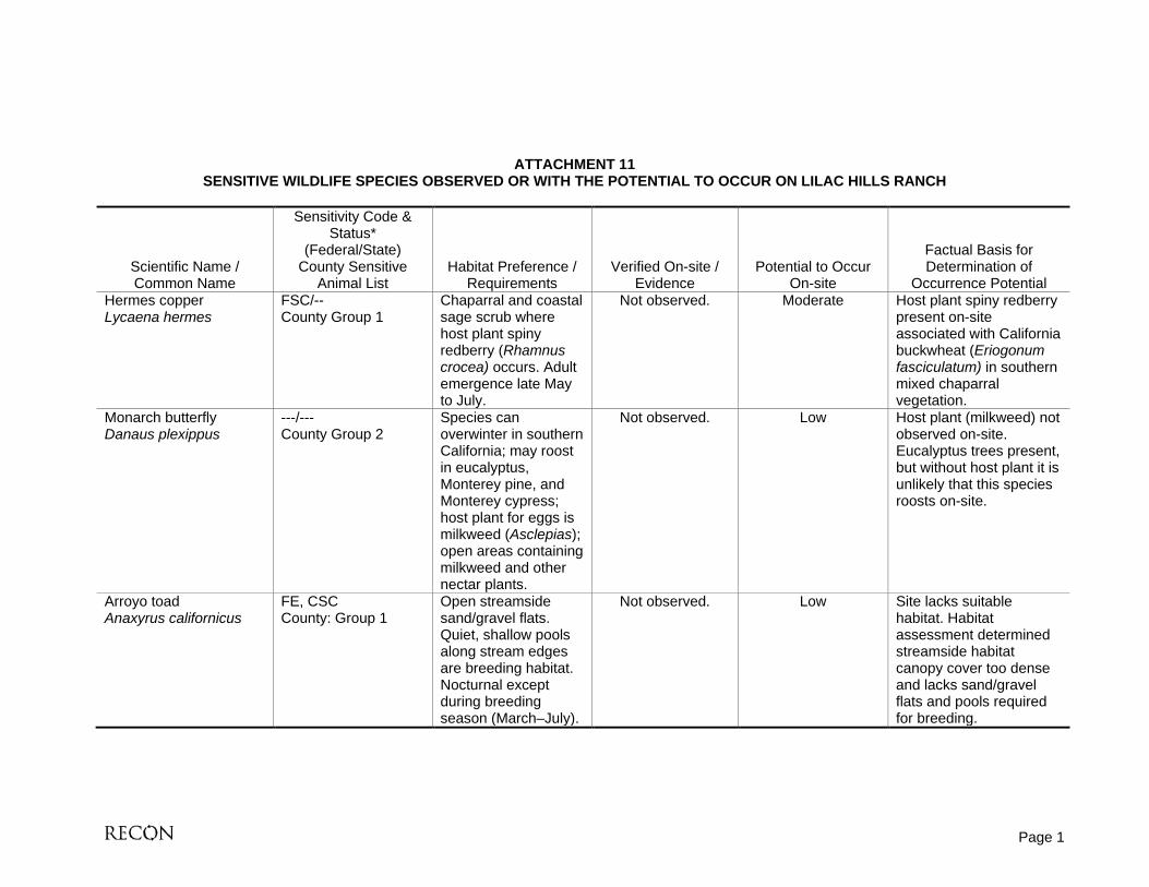
Occurrence Potential Hermes copper Lycaena hermes
FSC/-- County Group 1
Chaparral and coastal sage scrub where host plant spiny redberry (Rhamnus crocea) occurs. Adult emergence late May to July.
Not observed. Moderate Host plant spiny redberry present on-site associated with California buckwheat (Eriogonum fasciculatum) in southern mixed chaparral vegetation.
Monarch butterfly Danaus plexippus
---/--- County Group 2
Species can overwinter in southern California; may roost in eucalyptus, Monterey pine, and Monterey cypress; host plant for eggs is milkweed (Asclepias); open areas containing milkweed and other nectar plants.
Not observed. Low Host plant (milkweed) not observed on-site. Eucalyptus trees present, but without host plant it is unlikely that this species roosts on-site.
Arroyo toad Anaxyrus californicus
FE, CSC County: Group 1
Open streamside sand/gravel flats. Quiet, shallow pools along stream edges are breeding habitat. Nocturnal except during breeding season (March–July).
Not observed. Low Site lacks suitable habitat. Habitat assessment determined streamside habitat canopy cover too dense and lacks sand/gravel flats and pools required for breeding.

ATTACHMENT 11 SENSITIVE WILDLIFE SPECIES OBSERVED OR WITH THE POTENTIAL TO OCCUR ON LILAC HILLS RANCH
(continued)
Page 2
Scientific Name / Common Name
Sensitivity Code & Status*
(Federal/State) County Sensitive
Animal List Habitat Preference /
Requirements Verified On-site /
Evidence Potential to Occur
On-site
Factual Basis for Determination of
Occurrence Potential Southern Pacific pond turtle Actinemys [=Clemmys] marmorata pallida
FSC/CSC County: Group 1
Ponds, small lakes, marshes, slow-moving, sometimes brackish water.
Not observed. Moderate Intermittent streams on-site may support pools suitable for this species.
Coast horned lizard Phrynosoma coronatum (San Diego/blainvillii pop.)
FSC/CSC County: Group 2
Chaparral, coastal sage scrub with fine, loose soil. Partially dependent on harvester ants for forage.
Observed just off-site near southern mixed chaparral.
High Species observed just off-site, however, suitable habitat and food source occur on-site.
Belding’s orange-throated whiptail Aspidoscelis hyperythra beldingi
FSC/CSC County: Group 2
Chaparral, coastal sage scrub with coarse sandy soils and scattered brush.
Observed on-site near coastal sage scrub, southern mixed chaparral,
and southern coast live oak riparian
woodland.
High This species was observed in four locations on-site and is expected to occur in other suitable habitat areas.
Coastal whiptail Aspidoscelis tigris stejnegeri
FSC/-- County: Group 2
Coastal sage scrub, chaparral, woodlands, and streamsides where plants are sparsely distributed.
Observed on-site near a citrus
orchard.
High One individual of this lizard species was observed on-site and it is expected to occur in other suitable habitat areas.
Silvery legless lizard Anniella pulchra pulchra
FSC/CSC County: Group 2
Herbaceous layers with loose soil in coastal scrub, chaparral, and open riparian. Prefers dunes and sandy washes near moist soil.
Not observed. Low Project site lacks preferred habitat for this species.

ATTACHMENT 11 SENSITIVE WILDLIFE SPECIES OBSERVED OR WITH THE POTENTIAL TO OCCUR IN THE PROJECT AREA
(continued)
Page 3
Scientific Name / Common Name
Sensitivity Code & Status*
(Federal/State) County Sensitive
Animal List Habitat Preference /
Requirements Verified On-site /
Evidence Potential to Occur
On-site
Factual Basis for Determination of
Occurrence Potential Coastal rosy boa Lichanura trivirgata roseofusca
FSC County: Group 2
Coastal sage scrub, chaparral in inland and desert locales with rocky soils.
Not observed. Moderate Project site has some suitable habitat for this species, but may be too coastal.
San Diego ring-necked snake Diadophis punctatus similis
--/-- County: Group 2
Rocky areas in wet locales, such as swamps, damp forests, or riparian woodlands.
Not observed. Moderate Suitable riparian woodland habitat occurs on-site.
Red diamond rattlesnake Crotalus ruber
FSC/CSC County: Group 2
Desert scrub and riparian, coastal sage scrub, open chaparral, grassland, and agricultural fields.
Observed on-site near southern coast
live oak riparian woodland, southern
mixed chaparral.
High Two individuals were observed on-site and suitable habitat is present.
Western least bittern Ixobrychus exilis hesperis
FSC/CSC Brackish and freshwater marshes in the coastal lowland. Rare summer resident, rare in winter.
Not observed. Low Suitable habitat for this species not present on-site. Nearby historic occurrence was at an artificial lake.
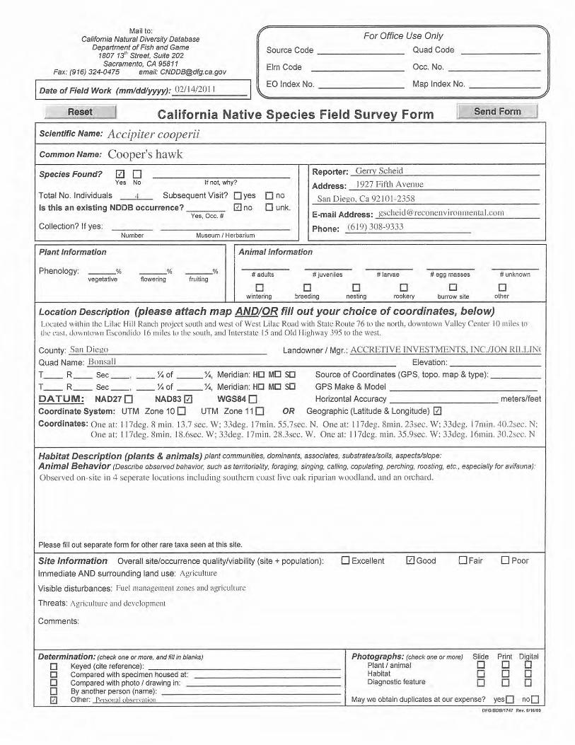
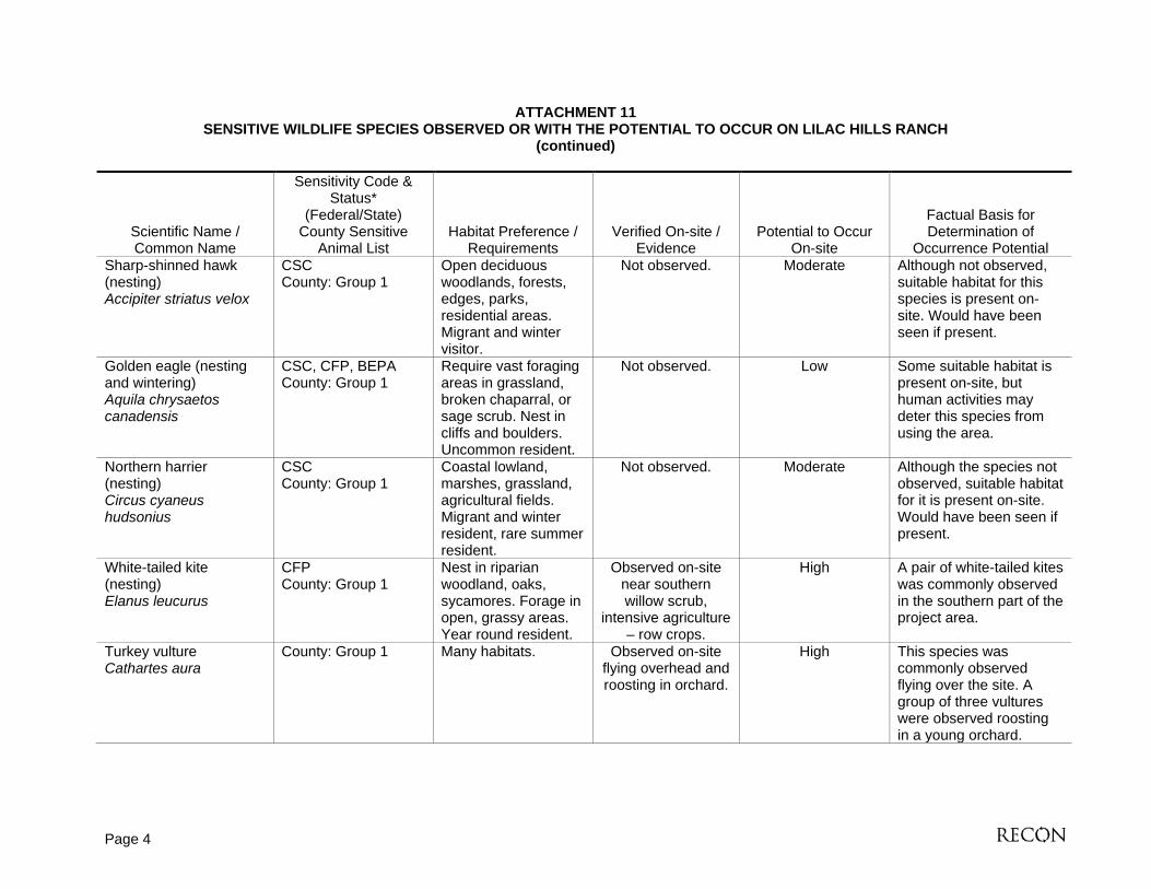
Cooper’s hawk (nesting) Accipiter cooperii
WL County: Group 1
Mature forest, open woodlands, wood edges, river groves. Parks and residential areas. Migrant and winter visitor.
Observed on-site in southern coast live
oak riparian woodland, orchard.
High Cooper’s hawks were observed on-site in four separate locations and suitable habitat to support this species is present.
ATTACHMENT 11 SENSITIVE WILDLIFE SPECIES OBSERVED OR WITH THE POTENTIAL TO OCCUR ON LILAC HILLS RANCH
(continued)
Page 4
Scientific Name / Common Name
Sensitivity Code & Status*
(Federal/State) County Sensitive
Animal List Habitat Preference /
Requirements Verified On-site /
Evidence Potential to Occur
On-site
Factual Basis for Determination of
Occurrence Potential Sharp-shinned hawk (nesting) Accipiter striatus velox
CSC County: Group 1
Open deciduous woodlands, forests, edges, parks, residential areas. Migrant and winter visitor.
Not observed. Moderate Although not observed, suitable habitat for this species is present on-site. Would have been seen if present.
Golden eagle (nesting and wintering) Aquila chrysaetos canadensis
CSC, CFP, BEPA County: Group 1
Require vast foraging areas in grassland, broken chaparral, or sage scrub. Nest in cliffs and boulders. Uncommon resident.
Not observed. Low Some suitable habitat is present on-site, but human activities may deter this species from using the area.
Northern harrier (nesting) Circus cyaneus hudsonius
CSC County: Group 1
Coastal lowland, marshes, grassland, agricultural fields. Migrant and winter resident, rare summer resident.
Not observed. Moderate Although the species not observed, suitable habitat for it is present on-site. Would have been seen if present.
White-tailed kite (nesting) Elanus leucurus
CFP County: Group 1
Nest in riparian woodland, oaks, sycamores. Forage in open, grassy areas. Year round resident.
Observed on-site near southern willow scrub,
intensive agriculture – row crops.
High A pair of white-tailed kites was commonly observed in the southern part of the project area.
Turkey vulture Cathartes aura
County: Group 1 Many habitats. Observed on-site flying overhead and roosting in orchard.
High This species was commonly observed flying over the site. A group of three vultures were observed roosting in a young orchard.

ATTACHMENT 11 SENSITIVE WILDLIFE SPECIES OBSERVED OR WITH THE POTENTIAL TO OCCUR IN THE PROJECT AREA
(continued)
Page 5
Scientific Name / Common Name
Sensitivity Code & Status*
(Federal/State) County Sensitive
Animal List Habitat Preference /
Requirements Verified On-site /
Evidence Potential to Occur
On-site
Factual Basis for Determination of
Occurrence Potential Western burrowing owl (burrow sites) Athene cunicularia hypugaea
FSC/CSC County: Group 1
Grassland, agricultural land, coastal dunes. Require rodent burrows. Declining resident.
Not observed. Low Habitat assessment determined that while suitable habitat is present (i.e., agricultural fields), the site generally lacked sufficient burrows and prey species to support burrowing owls.
Southwestern willow flycatcher Empidonax traillii extimus
FE, SE County: Group 1
Nesting restricted to willow thickets. Also occupies other woodlands. Rare spring and fall migrant, rare summer resident. Extremely localized breeding.
Not observed. Low Suitable habitat for this species is generally lacking on-site with the exception of a small patch of dense willow scrub in the southern portion of the site. However, this patch of willow scrub is too narrow to likely support the species.
Loggerhead shrike Lanius ludovicianus
CSC County: Group 1
Open foraging areas near scattered bushes and low trees.
Observed on-site near southern
mixed chaparral, orchard.
High One individual of this species was observed on-site. Suitable habitat is present.
Least Bell’s vireo (nesting) Vireo bellii pusillus
FE, SE County: Group 1
Willow riparian woodlands. Summer resident.
Not observed. Low Although suitable willow scrub habitat occurs on-site, protocol surveys failed to detect this species.
ATTACHMENT 11 SENSITIVE WILDLIFE SPECIES OBSERVED OR WITH THE POTENTIAL TO OCCUR ON LILAC HILLS RANCH
(continued)
Page 6
Scientific Name / Common Name
Sensitivity Code & Status*
(Federal/State) County Sensitive
Animal List Habitat Preference /
Requirements Verified On-site /
Evidence Potential to Occur
On-site
Factual Basis for Determination of
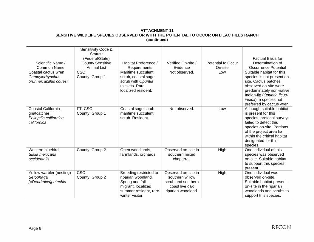
Occurrence Potential Coastal cactus wren Campylorhynchus brunneicapillus couesi
CSC County: Group 1
Maritime succulent scrub, coastal sage scrub with Opuntia thickets. Rare localized resident.
Not observed. Low Suitable habitat for this species is not present on-site. Cactus patches observed on-site were predominately non-native Indian-fig (Opuntia ficus-indica), a species not preferred by cactus wren.
Coastal California gnatcatcher Polioptila californica californica
FT, CSC County: Group 1
Coastal sage scrub, maritime succulent scrub. Resident.
Not observed. Low Although suitable habitat is present for this species, protocol surveys failed to detect this species on-site. Portions of the project area lie within the critical habitat designated for this species.
Western bluebird Sialia mexicana occidentalis
County: Group 2 Open woodlands, farmlands, orchards.
Observed on-site in southern mixed
chaparral.
High One individual of this species was observed on-site. Suitable habitat to support this species present.
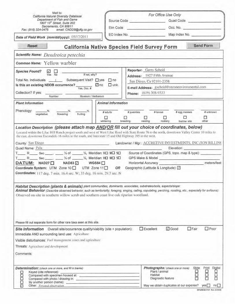
Yellow warbler (nesting) Setophaga [=Dendroica]petechia
CSC County: Group 2
Breeding restricted to riparian woodland. Spring and fall migrant, localized summer resident, rare winter visitor.
Observed on-site in southern willow
scrub and southern coast live oak
riparian woodland.
High One individual was observed on-site. Suitable habitat present on-site in the riparian woodlands and scrubs to support this species.

ATTACHMENT 11 SENSITIVE WILDLIFE SPECIES OBSERVED OR WITH THE POTENTIAL TO OCCUR IN THE PROJECT AREA
(continued)
Page 7
Scientific Name / Common Name
Sensitivity Code & Status*
(Federal/State) County Sensitive
Animal List Habitat Preference /
Requirements Verified On-site /
Evidence Potential to Occur
On-site
Factual Basis for Determination of
Occurrence Potential Yellow-breasted chat (nesting) Icteria virens auricollis
CSC County: Group 1
Dense riparian woodland. Localized summer resident.
Observed on-site in southern willow
scrub and southern coast live oak
woodland.
High Five individuals were observed on-site. Suitable habitat present on-site in the riparian woodlands and scrubs to support this species.
Southern California rufous-crowned sparrow Aimophila ruficeps canescens
FSC/CSC County: Group 1
Coastal sage scrub, chaparral, grassland. Resident.
Not observed. Low Although suitable habitat for this species occurs in the project area, this species was not observed during surveys. Would have been seen if present.
Grasshopper sparrow (nesting) Ammodramus savannarum perpallidus
FSC/-- County: Group 1
Tall grass areas. Localized summer resident, rare in winter.
Not observed. Low Suitable tall grass habitat is not present in the project area.
Bell’s sage sparrow Amphispiza belli belli
CSC County: Group 1
Chaparral, coastal sage scrub. Localized resident.
Not observed. Low Although suitable habitat for this species occurs in the project area, this species was not observed during surveys. Would have been seen if present.
California leaf-nosed bat Macrotus californicus
CSC Low deserts. Caves, mines, buildings. Colonial. Migrational. Mostly near Colorado River in California.
Not observed. Low Project location is outside of preferred geographical range for this species.
ATTACHMENT 11 SENSITIVE WILDLIFE SPECIES OBSERVED OR WITH THE POTENTIAL TO OCCUR ON LILAC HILLS RANCH
(continued)
Page 8
Scientific Name / Common Name
Sensitivity Code & Status*
(Federal/State) County Sensitive
Animal List Habitat Preference /
Requirements Verified On-site /
Evidence Potential to Occur
On-site
Factual Basis for Determination of
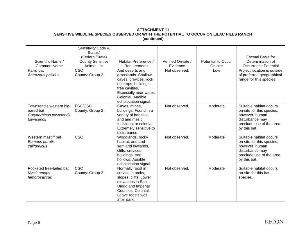
Occurrence Potential Pallid bat Antrozous pallidus
CSC County: Group 2
Arid deserts and grasslands. Shallow caves, crevices, rock outcrops, buildings, tree cavities. Especially near water. Colonial. Audible echolocation signal.
Not observed. Low Project location is outside of preferred geographical range for this species.
Townsend’s western big-eared bat Corynorhinus townsendii townsendii
FSC/CSC County: Group 2
Caves, mines, buildings. Found in a variety of habitats, arid and mesic. Individual or colonial. Extremely sensitive to disturbance.
Not observed. Moderate Suitable habitat occurs on-site for this species; however, human disturbance may preclude use of the area by this bat.
Western mastiff bat Eumops perotis californicus
CSC Woodlands, rocky habitat, arid and semiarid lowlands, cliffs, crevices, buildings, tree hollows. Audible echolocation signal.
Not observed. Moderate Suitable habitat occurs on-site for this species; however, human disturbance may preclude use of the area by this bat.
Pocketed free-tailed bat Nyctinomops femorosaccus
CSC County: Group 2
Normally roost in crevice in rocks, slopes, cliffs. Lower elevations in San Diego and Imperial Counties. Colonial. Leave roosts well after dark.
Not observed. Moderate Suitable habitat occurs on-site for this bat species.

ATTACHMENT 11 SENSITIVE WILDLIFE SPECIES OBSERVED OR WITH THE POTENTIAL TO OCCUR IN THE PROJECT AREA
(continued)
Page 9
Scientific Name / Common Name
Sensitivity Code & Status*
(Federal/State) County Sensitive
Animal List Habitat Preference /
Requirements Verified On-site /
Evidence Potential to Occur
On-site
Factual Basis for Determination of
Occurrence Potential Big free-tailed bat Nyctinomops macrotis
CSC County: Group 2
Rugged, rocky terrain. Roost in crevices, buildings, caves, tree holes. Very rare in San Diego County. Colonial. Migratory.
Not observed. Low Some suitable habitat occurs on-site for this species; however, project site may be outside of the preferred geographical range for this species.
Western yellow bat Lasiurus xanthunus
Dry tropical forest to semi-tropical wet forests; in southwestern U.S. can be found roosting in the skirt of dead fronds in both native and non-native palm trees.
Not observed. Low While some palm trees occur in the project area, there is not likely enough habitat to support a population of this bat species.
Small-footed myotis Myotis ciliolabrum
FSC/-- County Group 2
Great Basin desert scrub and pinion-juniper forest in California; roosts in rock crevices, caves, tunnels, mines, and sometimes buildings and under bridges.
Not observed. Low Suitable habitat for this bat species does not occur in the project area.

ATTACHMENT 11 SENSITIVE WILDLIFE SPECIES OBSERVED OR WITH THE POTENTIAL TO OCCUR ON LILAC HILLS RANCH
(continued)
Page 10
Scientific Name / Common Name
Sensitivity Code & Status*
(Federal/State) County Sensitive
Animal List Habitat Preference /
Requirements Verified On-site /
Evidence Potential to Occur
On-site
Factual Basis for Determination of
Occurrence Potential Long-eared myotis Myotis evotis
FSC/-- County: Group 2
Occurs in semiarid shrublands, sage, chaparral, and agricultural areas, but is usually associated with coniferous forest; roost under tree bark, in hollow trees, cavers, mines, cliff crevices, sinkholes, and rocky outcrops on the ground. Buildings and under bridges may also be used.
Not observed. Moderate Some suitable habitat for this bat species occurs in the project area; however, the preferred habitat (coniferous forest) is not present.
Fringed myotis Myotis thysanodes
FSC/-- County: Group 2
Oak woodland, forest, desert scrub, caves, mines.
Not observed. Moderate Some oak woodlands occur in the project area.
Long-legged myotis Myotis volans
FSC/-- County: Group 2
Associated with water in many areas; pinyon juniper, Joshua tree woodland, montane coniferous forest, forested habitat along the coast; roost in hollow trees, rock crevices, mines, buildings.
Not observed. Low Preferred habitat for this species does not occur in project area.

ATTACHMENT 11 SENSITIVE WILDLIFE SPECIES OBSERVED OR WITH THE POTENTIAL TO OCCUR IN THE PROJECT AREA
(continued)
Page 11
Scientific Name / Common Name
Sensitivity Code & Status*
(Federal/State) County Sensitive
Animal List Habitat Preference /
Requirements Verified On-site /
Evidence Potential to Occur
On-site
Factual Basis for Determination of
Occurrence Potential Yuma myotis Myotis yumanensis
FSC/CSC County: Group 2
Associated with permanent sources of water, typically rivers and streams; riparian, arid scrublands, deserts, forests; roosts in bridges, buildings, cliff crevices, caves, mines, and trees.
Not observed. Low Suitable habitat for this species does not occur on-site.
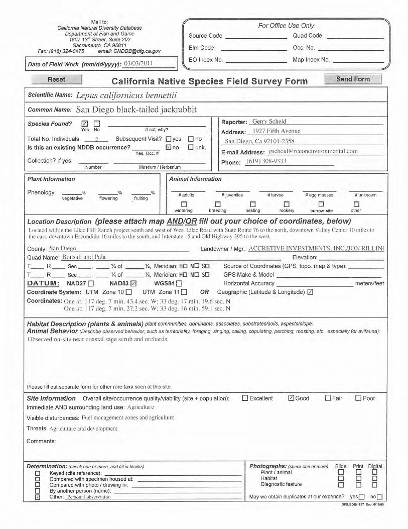
San Diego black-tailed jackrabbit Lepus californicus bennettii
FSC/CSC County Group 2
Open areas of scrub, grasslands, agricul-tural fields.
Observed on-site near coastal sage
scrub and orchards.
High Two individuals of this species were observed on-site. Suitable habitat to support this species occurs in the project area.
Dulzura pocket mouse Chaetodipus californicus femoralis
FSC/CSC County: Group 2
Brushy areas of coastal sage scrub, chamise-redshank & montane chaparral, sagebrush, annual grassland, valley foothill hardwood, valley foothill hardwood–conifer & montane hardwood. Probably most attracted to interface of grassland and brush.
Not observed. Moderate Suitable habitat for this species occurs on-site. Areas near agricultural operations may be affected by pest control management practices.

ATTACHMENT 11 SENSITIVE WILDLIFE SPECIES OBSERVED OR WITH THE POTENTIAL TO OCCUR ON LILAC HILLS RANCH
(continued)
Page 12
Scientific Name / Common Name
Sensitivity Code & Status*
(Federal/State) County Sensitive
Animal List Habitat Preference /
Requirements Verified On-site /
Evidence Potential to Occur
On-site
Factual Basis for Determination of
Occurrence Potential Northwestern San Diego pocket mouse Chaetodipus fallax fallax
FSC/CSC County: Group 2
San Diego County west of mountains in sparse, disturbed coastal sage scrub or grasslands with sandy soils.
Not observed. Low Project area lacks suitable habitat with sandy soils.
Stephens’ kangaroo rat Dipodomys stephensi
FE, ST County: Group 1
Grassland, open areas.
Not observed. Low Habitat assessment concluded that area lacks characteristics required by this species. No kangaroo rat burrows were observed. Agricultural pest control activities may affect the likely presence of this species.
Southern grasshopper mouse Onychomys torridus ramona
CSC County: Group 2
Low open and semi-open scrub habitats; coastal sage scrub, mixed chaparral, low sagebrush, riparian scrub, and annual grassland with scattered shrubs.
Not observed. Low While some areas of suitable habitat for this species are present in the project area, agricultural pest control activities may affect the likely presence of this species.
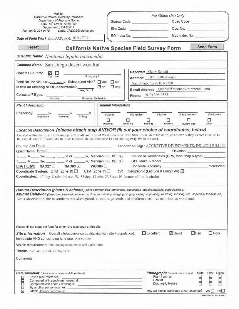
San Diego desert woodrat Neotoma lepida intermedia
FSC/CSC County: Group 2
Coastal sage scrub and chaparral.
Nests observed on-site in southern
mixed chaparral, coastal sage scrub, and southern coast
live oak riparian woodland.
High Woodrat nests were commonly observed in the southern mixed chaparral, coastal sage scrub, and riparian woodlands on-site.

ATTACHMENT 11 SENSITIVE WILDLIFE SPECIES OBSERVED OR WITH THE POTENTIAL TO OCCUR IN THE PROJECT AREA
(continued)
Page 13
Scientific Name / Common Name
Sensitivity Code & Status*
(Federal/State) County Sensitive
Animal List Habitat Preference /
Requirements Verified On-site /
Evidence Potential to Occur
On-site
Factual Basis for Determination of
Occurrence Potential Ringtail Bassariscus astutus
CFP County: Group 1
Cliffs, rocky ravines, chaparral communities.
Not observed. Low Human presence and level of activity may preclude this species from using habitats in the project area.
Mountain lion Puma concolor
CFP County: Group 2
Many habitats. Not observed. Moderate Project site supports prey species used by mountain lion, and the site covers a large acreage and has a water source. Level of human activity and presence may deter species from area.
Southern mule deer Odocoileus hemionus fuliginata
County: Group 2 Many habitats. Observed on-site in southern mixed
chaparral.
High Three mule deer were observed on-site, and suitable habitat to support this species is present.
*Sensitivity Codes and Status: FE – Federally listed endangered; FT – Federally listed threatened; FSC – Federal Species of Concern; SE – California State listed endangered; ST – California State listed threatened; CSC – California species of special concern; CFP – California fully protected species; BEPA – Bald Eagle Protection Act; WL=CDFW Watch List. County of San Diego Sensitive Animal List: Group 1 = Animals of high sensitivity (listed or natural history requirements); Group 2 = Animals declining, but not in immediate threat of extinction or extirpation.

ATTACHMENT 11 SENSITIVE WILDLIFE SPECIES OBSERVED OR WITH THE POTENTIAL TO OCCUR ON LILAC HILLS RANCH
(continued)
Page 14
THIS PAGE IS INTENTIONALLY BLANK.

ATTACHMENT 12
Jurisdictional/Wetland Delineation Report for the Lilac Hills Ranch Specific Plan and General Plan
Amendment Area, Escondido, California

THIS PAGE IS INTENTIONALLY BLANK.


Jurisdictional/Wetland Delineation Report for the Lilac Hills Ranch Specific Plan and General Plan Amendment
TABLE OF CONTENTS
1.0 Summary of Findings 1
2.0 Introduction 2
3.0 Methods and Jurisdictions 2
3.1 U.S. Army Corps of Engineers 2
3.1.1 Regulatory Definition 6 3.1.2 Isolated Waters 6 3.1.3 Wetland Parameters 7 3.1.4 Non-wetland Jurisdictional Waters 10 3.1.5 Atypical Situations 10
3.2 CDFG and RWQCB 11
3.3 County of San Diego 11
4.0 Results of Field Data 12
4.1 Vegetation 12
4.1.1 Areas with Hydrophytic Vegetation 15 4.1.2 Areas Lacking Hydrophytic Vegetation 15
4.2 Soils 16
4.3 Hydrology 16
5.0 Location of Jurisdictional Waters 17
5.1 USACE Jurisdictional Waters 17
5.1.1 Non-wetland Waters of the U.S. 17 5.1.2 Wetland Waters of the U.S. 18
5.2 CDFG/RWQCB Waters of the State 18
5.3 County of San Diego RPO Wetlands 18
6.0 Regulatory Issues 31
7.0 References Cited 32

Jurisdictional/Wetland Delineation Report for the Lilac Hills Ranch Specific Plan and General Plan Amendment
TABLE OF CONTENTS (CONT.)
FIGURES
1: Regional Location 3 2: Project Location on USGS Map 4 3: Project Location on Aerial Photograph 5 4: Vegetation Communities and Land Cover Types 13 5a: Location of USACE Waters of the U.S. 19 5b: Location of USACE Waters of the U.S. 21 6a: Location of CDFG/RWQCB State Waters 23 6b: Location of CDFG/RWQCB State Waters 25 7a: Location of County of San Diego RPO Wetlands 27 7b: Location of County of San Diego RPO Wetlands 29
TABLES
1: Vegetation Communities and Land Cover Types 15 2: Existing Jurisdictional Waters within the Project Area 17
ATTACHMENTS
1: Wetland Determination Forms

Jurisdictional/Wetland Delineation Report for the Lilac Hills Ranch Specific Plan and General Plan Amendment
Page 1
1.0 Summary of Findings RECON biologists conducted a routine wetland delineation on the approximately 610-acre Lilac Hills Ranch Master Plan project site during the spring and early summer of 2011. Methods for delineating wetlands followed guidelines set forth by the U.S. Army Corps of Engineers (USACE), including the 1987 wetland delineation manual and the 2008 Regional Supplement to the Corps of Engineers Wetland Delineation Manual: Arid West Region (USACE 1987, 2008).
A total of 13.44 acres of jurisdictional USACE wetlands were delineated on the site that had the three wetland parameters: hydrophytic vegetation, hydric soils, and wetland hydrology. An additional 4.69 acres of non-wetland waters of the U.S. were delineated on-site, and these non-wetland areas were delineated by an observable ordinary high water mark.
State wetlands and waters under the jurisdiction of the California Department of Fish and Game (CDFG) and Regional Water Quality Control Board (RWQCB) were also delineated on-site. CDFG/RWQCB jurisdiction totals 4.18 acres of streambed and 39.35 acres of wetlands.
County of San Diego (County) Resource Protect Ordinance (RPO) wetlands were also delineated on the project site. A total of 42.88 acres of RPO wetlands are identified.
Impacts to jurisdictional waters, including any wetlands, on-site would require a 404 Permit from the USACE, a 1602 Streambed Alteration Agreement from CDFG, and a 401 Water Quality Certification from the RWQCB. Impacts to County RPO wetlands are to be avoided to the maximum extent possible, and any unavoidable impacts would require County approval and mitigation per County standards.

FIGURE 1
Regional Location
RIVERSIDE COUNTY
SAN DIEGO COUNTY
RIVERSIDE COUNTY
SAN DIEGO COUNTY
0 4Miles [
M:\JOBS4\6153\common_gis\fig1.mxd 9/12/2011
Project Locationk
k

FIGURE 2
Project Location on USGS Map
Map Source: USGS 7.5 minute topographic map series, Pala & Bonsall quadrangles, T10SR02W & T10SR03W
0 2,000Feet [
Project Boundary
M:\JOBS4\6153\common_gis\fig2.mxd 4/2/2012
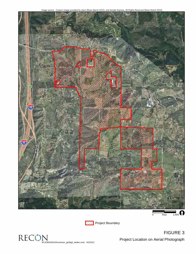
FIGURE 3
Project Location on Aerial Photograph
Image source: Custom image provided by client (flown March 2012), and Aerials Express, All Rights Reserved (flown March 2010)
0 1,500Feet [
Project Boundary
M:\JOBS4\6153\common_gis\fig3_wettec.mxd 4/2/2012

Jurisdictional/Wetland Delineation Report for the Lilac Hills Ranch Specific Plan and General Plan Amendment
Page 2
2.0 Introduction This report describes the results of a wetland delineation conducted on the Lilac Hills Ranch project site. The wetland delineation is used to identify and map the extent of the federal jurisdictional waters of the U.S., including adjacent wetlands, state wetlands/waters, and County RPO wetlands.
The Lilac Hills Ranch project area is located within an unincorporated portion of the County of San Diego, California (Figure 1). The project site is located in Townships 10 South, Range 2 and 3 West, on the U.S. Geological Survey (USGS) 7.5-minute topographical maps, Bonsall, California, and Pala California quadrangles (Figure 2). The Lilac Hills Ranch project site lies east of Interstate 15 and to the south and east of West Lilac Road (Figure 3).
The purpose of this study was to identify and map the location of jurisdictional waters to provide necessary background information for analysis by USACE, CDFG/RWQCB, and the County. The biological technical report for the Lilac Hills Ranch project (RECON 2012) contains additional detailed biological resource information for the survey area.
3.0 Methods and Jurisdictions A routine wetland delineation, following the guidelines set forth by USACE (1987, 2008), was performed to gather field data at potential jurisdictional waters in the survey area. RECON biologists Gerry Scheid, Anna Bennett, and Erin McKinney conducted the routine delineation fieldwork. Prior to conducting the delineation, aerial photographs and USGS topographic maps of the site were examined. Once on-site, the potential federal, state, and county jurisdictional areas were examined to determine the presence and extent of any jurisdictional waters.
3.1 U.S. Army Corps of Engineers
As stated in the federal regulations for the Clean Water Act (CWA), wetlands are defined as:
. . . those areas that are inundated or saturated by surface or groundwater at a frequency and duration sufficient to support, and that under normal circumstances, do support a prevalence of vegetation typically adapted for life in saturated soil conditions (Environmental Protection Agency [EPA], 40 CFR 230.3 and CE, 33 Code of Federal Regulations [CFR] 328.3).

Jurisdictional/Wetland Delineation Report for the Lilac Hills Ranch Specific Plan and General Plan Amendment
Page 6
Wetlands are delineated using three parameters, which include hydrophytic vegetation, wetland hydrology, and hydric soils. According to USACE, indicators for all three parameters must be present to qualify an area as a wetland.
3.1.1 Regulatory Definition In accordance with Section 404 of the CWA, USACE regulates the discharge of dredged or fill material into waters of the U.S. The term “waters of the United States” is defined as:
• All waters currently used, or used in the past, or may be susceptible to use in interstate or foreign commerce, including all waters subject to the ebb and flow of the tide;
• All interstate waters including interstate wetlands;
• All other waters such as intrastate lakes, rivers, streams (including intermittent streams), mudflats, sandflats, wetlands, sloughs, prairie potholes, wet meadows, playa lakes, or natural ponds; the use, degradation, or destruction of which could affect foreign commerce including any such waters: (1) which could be used by interstate or foreign travelers for recreational or other purposes; or (2) from which fish or shellfish are, or could be taken and sold in interstate or foreign commerce; or (3) which are used or could be used for industries in interstate commerce.
• All other impoundments of waters otherwise as defined as waters of the United States under the definition;
• Tributaries of waters identified above;
• The territorial seas; and
• Wetlands adjacent to waters (other than waters that are themselves wetlands) identified in the paragraphs above [33 CFR Part 328.3(a)].
3.1.2 Isolated Waters Federal regulatory authority only extends to activities that affect interstate commerce pursuant to Article 1, Section 8 of the U.S. Constitution. Prior to 1985, in accordance with the interstate commerce requirement, USACE restricted its jurisdiction on isolated (intrastate) waters such as ponds or vernal pools lacking connection to waters of the U.S. On September 12, 1985, the EPA issued a memorandum asserting USACE’s jurisdiction over isolated waters that are used or could be used by migratory birds or endangered species. This assertion became known as the “Migratory Bird Rule.”

Jurisdictional/Wetland Delineation Report for the Lilac Hills Ranch Specific Plan and General Plan Amendment
Page 7
Consequently, the definition of “waters of the United States” in USACE regulations was modified to include isolated waters that qualified under the Migratory Bird Rule.
On January 9, 2001, the Supreme Court of the United States issued a decision on Solid Waste Agency of Northern Cook County versus United States Army Corps of Engineers, et al. with respect to whether the use of an isolated, intrastate pond by migratory birds is sufficient interstate commerce to warrant USACE jurisdiction over that pond, pursuant to Section 404 of the CWA. The court held that the Migratory Bird Rule is not a fairly supported interpretation of the term “waters of the United States.” By determining that Congress was not intended to regulate isolated wetlands under the CWA, the Supreme Court shifted the regulatory burden to states and local governments. However, the 2001 ruling did not refute the court’s earlier decision in the United States versus Riverside Bayview Homes, Inc. that upheld USACE jurisdiction over wetlands adjacent to navigable waters, nor did it express any opinion on the authority of USACE to regulate wetlands that are not adjacent to bodies of open water above and beyond the Migratory Bird Rule.
3.1.3 Wetland Parameters
3.1.3.1 Hydrophytic Vegetation
Hydrophytic vegetation is defined as “the sum total of macrophytic plant life growing in water or on a substrate that is at least periodically deficient in oxygen as a result of excessive water content” (USACE 1987). The potential wetland areas were surveyed by walking throughout the site and making observations of those areas exhibiting characteristics of jurisdictional waters or wetlands. Vegetation units with the potential to be wetlands were examined, and data for each vegetation stratum (i.e., tree, shrub, herb, and vine) were recorded on the datasheet provided in the 2008 Arid Supplement (USACE 2008). The percent absolute cover of each species present was visually estimated and recorded.
The wetland indicator status of each species recorded was determined by using the list of wetland plants for California provided by the United States Fish and Wildlife Service (USFWS 1997). An obligate (OBL) indicator status refers to plants that have a 99 percent probability of occurring in wetlands under natural conditions. A Facultative-Wet (FACW) indicator status refers to plants that occur in wetlands (67–99 percent probability), but are occasionally found in non-wetlands. A Facultative (FAC) indicator status refers to plants that are equally likely to occur in wetlands or non-wetlands (estimated probability 34–66 percent). Facultative upland (FACU) species are more often found in upland sites. Upland (UPL) species have a high probability to occur in upland sites. An NI indicator status refers to species that have insufficient data available to determine an indicator status at this time for the local region.

Jurisdictional/Wetland Delineation Report for the Lilac Hills Ranch Specific Plan and General Plan Amendment
Page 8
Plant species nomenclature follows that contained in The Jepson Manual (Hickman 1993). Dominant species with an indicator status of “NI” (not indicated) or not listed in the USFWS 1997 list were evaluated as either wetland or upland indicator species based on local professional knowledge of where the species are most often observed in habitats that are characteristic in southern California.
There are three indicators or tests to determine hydrophytic vegetation on a site: the dominance test, prevalence index, and morphological adaptations. The 50/20 rule is a repeatable and objective procedure for selecting dominant plant species and is recommended when data are available for all species in the community (USACE 2008). Dominant species are those plants that individually or collectively contribute more than 50 percent of the total vegetative cover plus those species that, by themselves, comprise 20 percent or more of the total cover.
If the vegetation at a particular site passes the dominance test (using the 50/20 rule), the hydrophytic vegetation criterion is considered fulfilled. If it fails the dominance test, and positive indicators of hydric soils and/or wetland hydrology are present, it is necessary to apply the prevalence index. The prevalence index is a weighted-average wetland indicator status of all plant species at a test site, where each indicator status category is given a numeric code and weighting by percent cover (USACE 2008). If a prevalence index is 3.0 or less, the hydrophytic vegetation criterion is considered fulfilled.
If a site fails the prevalence index and positive indicators of hydric soils and/or wetland hydrology are present, it is necessary to assess the presence or absence of morphological adaptations. To apply this indicator, morphological features must be observed on more than 50 percent of the individuals of a FACU species living in an area where indicators of hydric soil and wetland hydrology are present (USACE 2008). Once this indicator is applied, the dominance test and/or the prevalence index are/is recalculated using a FAC indicator status of this species (USACE 2008).
3.1.3.2 Hydric Soils
A hydric soil is a soil that is saturated, flooded, or ponded long enough during the growing season to develop anaerobic conditions that favor the growth and regeneration of hydrophytic vegetation (USACE 1987). Hydric soil indicators are formed predominantly by the accumulation or loss of iron, manganese, sulfur, or carbon compounds (USACE 2008). The hydric soil criterion is considered fulfilled at a location if soils in the area can be inferred to have a high groundwater table, evidence of prolonged soil saturation, or any indicators suggesting a long-term reducing environment in the upper 18 inches of the soil profile.
Sample points were selected within potential wetland areas and where the apparent boundary between wetland and upland was inferred based on changes in the

Jurisdictional/Wetland Delineation Report for the Lilac Hills Ranch Specific Plan and General Plan Amendment
Page 9
composition of the vegetation and topography. Soil pits were dug to a depth of at least 18 inches or to a depth necessary to determine soil color, evidence of soil saturation, depth to groundwater, and indicators of a reducing soil environment (i.e., mottling, gleying, and sulfidic odor).
Hydric soil indicators are presented in three groups in the Arid Supplement (USACE 2008) “all soils,” “sandy soils,” and “loamy and clayey soils.” Indicators applicable to all soil textures are indicated as A1 through A10 on the datasheet and include histosols, histic epipedon, stratified layers, and muck, among others. Indicators in sandy soils are noted as S1 through S6 and include sandy gleyed matrix, sandy redox, and stripped matrix. F1 (loamy mucky mineral) through F9 (vernal pools) are indicators of hydric conditions within loamy and clayey soils. A complete description of each of the hydric soil indicators is provided in the 2008 Arid Supplement and should be referenced during each delineation.
3.1.3.3 Wetland Hydrology
The presence of wetland hydrology indicators confirm that inundation or saturation has occurred on a site, but may not provide information about the timing, duration, or frequency of the event. Hydrology features are generally the most ephemeral of the three wetland parameters (USACE 2008).
In the 2008 Arid Supplement, wetland hydrology indicators are divided into four groups. Those that are determined based on direct observation are in Group A. These include the presence of surface water, a high water table, and saturation. Water marks, drift deposits, surface soil cracks, and other indicators of flooding or ponding fall within Group B. Group C consists of indicators that provide indirect evidence that a site was saturated recently, such as the presence of sulfidic odors or oxidized rhizospheres along living roots. Finally, Group D consists of vegetation and soil features that indicate recent wet conditions such as the FAC-neutral test or a shallow aquitard (USACE 2008). These indicators are further classified as primary or secondary indicators.
Hydrologic information for the site was obtained by reviewing USGS topographic maps and by directly observing hydrology indicators in the field. The wetland hydrology criterion is considered fulfilled at a location if, based upon the conclusions inferred from the field observations, an area has a high probability of being periodically inundated or has soils saturated to the surface at some time during the growing season to develop anaerobic conditions in the surface soil environment, especially the root zone (USACE 1987). If at least one primary indicator or at least two secondary indicators are found at a sample point, the wetland hydrology criterion is considered fulfilled.

Jurisdictional/Wetland Delineation Report for the Lilac Hills Ranch Specific Plan and General Plan Amendment
Page 10
3.1.4 Non-wetland Jurisdictional Waters The USACE requires the delineation also of non-wetland jurisdictional waters. These waters must have strong hydrology indicators such as the presence of seasonal flows and an ordinary high watermark. An ordinary high watermark is defined as:
. . . that line on the shore established by the fluctuations of water and indicated by physical characteristics such as [a] clear, natural line impressed on the bank, shelving, changes in the character of soil, destruction of terrestrial vegetation, the presence of litter and debris, or other appropriate means that consider the characteristics of the surrounding areas (33 CFR Part 328.3).
Areas delineated as non-wetland jurisdictional waters may lack wetland vegetation or hydric soil characteristics. Hydric soil indicators may be missing, because topographic position precludes ponding and subsequent development of hydric soils. Absence of wetland vegetation can result from frequent scouring due to rapid water flow. These types of jurisdictional waters are delineated by the lateral and upstream/downstream extent of the ordinary high watermark of the particular drainage or depression.
3.1.5 Atypical Situations The definition of a wetland includes the phrase “under normal circumstances” because there are situations in which the vegetation of a wetland has been removed or altered because of recent natural events or human activities (USACE 1987).
To describe these conditions, USACE uses definitions for atypical situations and problem areas. They are as follows:
Atypical situation: . . . refers to areas in which one or more parameters (vegetation, soil, and/or hydrology) have been sufficiently altered by recent human activities or natural events to preclude the presence of wetland indicators of the parameter (USACE 1987).
Problem areas: . . . wetland types in which wetland indicators of one or more parameters may be periodically lacking due to normal seasonal or annual variations in environmental conditions that result from causes other than human activities or catastrophic natural events. Representative examples of problem areas include seasonal wetlands, wetlands on drumlins, prairie potholes, and vegetated flats (USACE 1987).
Atypical situations and problem areas may lack one or more of the three criteria and still be considered wetlands if background information on the previous condition of the area and field observations indicate that the missing wetland criteria were present before the
Jurisdictional/Wetland Delineation Report for the Lilac Hills Ranch Specific Plan and General Plan Amendment
Page 11
disturbance and would occur at the site under normal circumstances. Additional delineation procedures would be employed, if normal circumstances did not occur on a site.
3.2 CDFG and RWQCB
Under sections 1600–1607 of the Fish and Game Code, CDFG regulates activities that would divert or obstruct the natural flow or substantially change the bed, channel, or bank of any river, stream, or lake that supports fish or wildlife. CDFG has jurisdiction over riparian habitats (e.g., southern willow scrub) associated with watercourses. Jurisdictional waters are delineated by the outer edge of riparian vegetation or at the top of the bank of streams or lakes, whichever is wider.
RWQCB is the regional agency responsible for protecting water quality in California. The jurisdiction of this agency includes all waters of the state and all waters of the United States as mandated by both the federal CWA and the California Porter-Cologne Water Quality Control Act. State waters are all waters that meet one of three criteria (hydrology, hydric soils, or wetland vegetation), and generally include but are not limited to, all waters under the jurisdiction of USACE and CDFG.
3.3 County of San Diego
According to the County RPO (County of San Diego 2007), wetlands are:
1. Lands having one or more of the following attributes are “wetlands”:
(aa). At least periodically, the land supports a predominance of hydrophytes (plants whose habitat is water or very wet places);
(bb). The substratum is predominantly undrained hydric soil: or
(cc). An ephemeral or perennial stream is present, whose substratum is predominately non-soil and such lands contribute substantially to the biological functions or values of wetlands in the drainage system.
2. Notwithstanding paragraph (1) above, the following shall not be considered “wetlands”:
(aa). Lands which have attribute(s) specified in paragraph (1) solely due to man-made structures (e.g., culverts, ditches, road crossings, or agricultural ponds), provided that the Directo of Planning and Land Use determines that they:
(i) Have negligible biological function or value as wetlands;
Jurisdictional/Wetland Delineation Report for the Lilac Hills Ranch Specific Plan and General Plan Amendment
Page 12
(ii) Are small and geopraphically isolated from other wetland systems;
(iii) Are not vernal pools; and,
(iv) Do not have substantial or locally important populations of wetland dependent sensitive species.
(bb). Lands that have been degraded by past legal land disturbance activities, to the point that they meet the following criteria as determined by the Director of Planning and Land Use:
(i) Have negligible biological function or value as wetlands even if restored to the extent feasible; and,
(ii) Do not have substantial or locally important populations of wetland dependent sensitive species.
4.0 Results of Field Data A description of the hydrophytic vegetation units observed, soil types encountered, and a discussion of the local hydrology in the survey area are presented below. Copies of the field data forms summarizing information collected in the field on vegetation, soils, and hydrology observed at each sample site are provided in Attachment 1.
4.1 Vegetation
Eighteen vegetation communities occur on the property, with some vegetation communities also having disturbed categories. The acreages of the habitats and vegetation communities present in the survey area are summarized in Table 1 and shown on Figure 4.

FIGURE 4
Vegetation Communities and Land Cover Types
W L I L A C R D
NE L S O N W Y
SH
I RE
Y R
D
C O V E Y L N
LIL
AC
W
K
PA
LO
S V
ER
D
ES
DR
RO
DR
IG
UE
Z
RD
OL
D H
I GH
WA
Y 3
95
ST
AN
DE
L L
N
R I T S O N R D
LIL
AC
P
LR
OC
KI N
G H
OR
SE
R
D
E L M O N D D R
N U T B Y L N
MO
UN
TA
IN
R
ID
GE
R
D
W L I L A C R D
NE L S O N W Y
SH
I RE
Y R
D
C O V E Y L N
LIL
AC
W
K
PA
LO
S V
ER
D
ES
DR
RO
DR
IG
UE
Z
RD
OL
D H
I GH
WA
Y 3
95
ST
AN
DE
L L
N
R I T S O N R D
LIL
AC
P
LR
OC
KI N
G H
OR
SE
R
D
E L M O N D D R
N U T B Y L N
MO
UN
TA
IN
R
ID
GE
R
D
M:\JOBS4\6153\common_gis\fig4_wettec.mxd 4/2/2012
0 900Feet [
Image source: Custom image provided by client (flown March 2012), and Aerials Express, All Rights Reserved (flown March 2010)
Project Boundary
Vegetation Communities and Landcover Type
Coastal Sage Scrub (32520)
Disturbed Coastal Sage Scrub (32520)
Southern Mixed Chaparral (37120)
Disturbed Southern Mixed Chaparral (37120)
Coast Live Oak Woodland (71160)
Eucalyptus Woodland (79100)
Southern Willow Scrub (63320)
Disturbed Southern Willow Scrub (63320)
Southern Coast Live Oak Riparian Woodland (61310)
Dist. Southern Coast Live Oak Riparian Woodland (61310)
Southern Willow Riparian Woodland (62500)
Coastal/Valley Freshwater Marsh (52410)
Disturbed Coastal/Valley Freshwater Marsh (52410)
Mule Fat Scrub (63310)
Disturbed Wetland (11200)
Open Water - Fresh water (64140)
Open Water - Fresh water Agricultue pond (64140)
Disturbed Habitat (11300)
Extensive Agriculture - Row Crops (18320)
Intensive Agriculture - Nursery (18200)
Orchard (18100)
Vinyard (18100)
Developed (12000)

THIS PAGE IS INTENTIONALLY BLANK.

Jurisdictional/Wetland Delineation Report for the Lilac Hills Ranch Specific Plan and General Plan Amendment
Page 15
TABLE 1
EXISTING HABITAT / VEGETATION COMMUNITIES
Habitat / Vegetation Communities Acres Coast live oak woodland (71160) 3.58
Coastal sage scrub (32520) 18.74 Disturbed Coastal sage scrub (32520) 2.80 Disturbed Coastal/Valley freshwater marsh (52410) 0.59 Eucalyptus woodland (79100) 1.64
Southern coast live oak riparian woodland (61310) 22.85 Disturbed Southern coast live oak riparian woodland (61310) 1.94 Southern mixed chaparral (37120) 76.40 Disturbed Southern mixed chaparral (37120) 6.13 Southern willow riparian woodland (62500) 4.74 Southern willow scrub (63320) 6.14 Disturbed Southern willow scrub (63320) 0.28
Mule fat scrub (63310) 0.06 Open water – fresh water (64140) 0.46 Disturbed wetland (11200) 0.35 Extensive agriculture – row crops (18320) 91.15 Intensive agriculture – nursery (18200) 9.59 Vineyard (18100) 0.66 Orchard (18100) 292.57 Disturbed habitat (11300) 43.42 Developed (12000) 26.67
Total 610.76
4.1.1 Areas with Hydrophytic Vegetation The following vegetation communities contain plant species that are considered hydrophytic vegetation: coastal/Valley freshwater marsh, southern coast live oak riparian woodland, southern willow scrub, and disturbed wetland. These vegetation communities are dominated by plant species that have a wetland indicator status of obligate, facultative-wet, or facultative species.
4.1.2 Areas Lacking Hydrophytic Vegetation Habitats and vegetation communities present on-site that lack hydrophytic vegetation include coast live oak woodland, coastal sage scrub, eucalyptus woodland, non-native grassland, southern mixed chaparral, extensive agriculture - row crops, intensive agriculture – nursery, vineyard, orchard, disturbed habitat, and developed land. These habitats and vegetation communities are dominated by upland plant species.
Jurisdictional/Wetland Delineation Report for the Lilac Hills Ranch Specific Plan and General Plan Amendment
Page 16
4.2 Soils
Information on the soil types sampled in the survey area is summarized from the Soil Survey for San Diego County (U.S. Department of Agriculture [USDA] 1973), the San Diego Association of Governments’ 1995 geographic information system data, and the Hydric Soils of California list obtained from the Natural Resource Conservation Service (1995).
Three soil types were encountered at sample points on the property and are described below according to the classifications from the USDA characterizations of soil types in the County (USDA 1973).
• Cienaba coarse sandy loam, 15 – 30 and 30 – 65 percent slopes (CIE2, CIG2), belong to a series of soils that are excessively drained very shallow to shallow coarse sandy loams that developed from material weathered in place from granitic rock. Cienaba coarse sandy loams are moderate to steep sloping, and therefore have a medium to rapid runoff and moderate to high erosion hazard.
• Fallbrook sandy loam, 15 – 30 percent slopes (FaE2), consists of well-drained, moderately deep to deep sandy loams developed in material weathered in place from granodiorite. The moderately steep slopes that contain this soil on-site have medium to rapid runoff and moderate to high erosion hazard.
• Steep gullied land (StG) consists of sloping to steep land areas that are actively undergoing erosion into old alluvium or decomposed rock. Gullies of various sizes are common within this soil series. Runoff is very rapid and the erosion hazard very high.
Hydric soil indicators observed at sample points within wetland areas included depleted matrix (i.e., presence of mottles, low chroma colors) and hydrogen sulfide odor.
4.3 Hydrology
The project area contains a number of drainages that flow from the north and east towards the southwestern portion of the site. The water flows off-site through a series of man-made ponds within a development and then southward to join Moosa Creek to the east of Interstate 15. Moosa Creek flows in a westerly direction, where it converges with the San Luis Rey River.

Jurisdictional/Wetland Delineation Report for the Lilac Hills Ranch Specific Plan and General Plan Amendment
Page 17
The source of the water that flows in the drainages on the site comes from seasonal storm water runoff and urban/agricultural runoff. The flow regime of the drainages on-site is either intermittent or ephemeral, depending on the particular drainage. Hydrology indicators commonly observed in wetland areas included one or more of the following: surface water, high water table, saturation, water marks, riverine drift lines, or sediment deposits.
5.0 Location of Jurisdictional Waters Jurisdictional waters were delineated on-site according to USACE, CDFG/RWQCB, and County regulations. Acreages of jurisdictional waters for each of the different jurisdictions are provided in Table 2. Figures 5a,b, 6a,b, and 7a,b show the locations of the jurisdictional waters identified on-site for each agency jurisdiction.
TABLE 2
EXISTING JURISDICTIONAL WATERS WITHIN THE PROJECT AREA (acres)
Jurisdictional Waters Total
USACE Jurisdiction Non-wetland waters of the U.S. 4.69 Wetlands 13.44
USACE Total Jurisdiction 18.13 CDFG/RWQCB Jurisdiction1 Streambed 4.18 State Wetlands (Riparian habitat) 39.35
CDFG Total Jurisdiction1 43.52 County of San Diego RPO Wetlands 42.88
1 CDFG/RWQCB area of jurisdiction overlaps all USACE jurisdictional waters.
5.1 USACE Jurisdictional Waters
USACE jurisdictional waters on the site include both wetland and non-wetland waters. These waters of the U.S. are discussed below.
5.1.1 Non-wetland Waters of the U.S. A total of 4.69 acres of non-wetland waters of the U.S. considered to fall within USACE jurisdiction were delineated on-site (see Figures 5a and b). Jurisdictional non-wetland waters on the site include the upland vegetated ephemeral drainages that are tributary to the larger drainage courses in the project area. These non-wetland drainage courses lack hydrophytic vegetation, hydric soils, and/or wetland hydrology, but convey runoff

Jurisdictional/Wetland Delineation Report for the Lilac Hills Ranch Specific Plan and General Plan Amendment
Page 18
that supports wetlands in the main drainage courses. The lateral extent of the non-wetland waters was determined by the observable ordinary high water mark.
The presence of an ordinary high watermark and a connection to the larger drainage courses that support wetland were used to determine the jurisdictional status of each of the drainages. The acreage for these waters of the U.S. was determined by multiplying the lateral extent of the ordinary high watermarks at selected locations by the length of the drainage channel.
5.1.2 Wetland Waters of the U.S. Portions of the southern coast live oak riparian woodlands, southern willow scrub, and freshwater marsh areas along the drainage courses on the site satisfy the three parameter criteria for USACE wetlands. Wetland waters of the U.S. on-site include all wetlands within the ordinary high water mark and all wetlands that are adjacent to it. A total of 13.44 acres of wetland waters of the U.S. were delineated on-site (see Figures 5a and b).
5.2 CDFG/RWQCB Waters of the State
State waters under the jurisdiction CDFG/RWQCB on-site include both unvegetated or upland vegetated streambeds and wetlands (see Figures 6a and b). Streambeds delineated on-site include the ephemeral drainages that drain into the larger drainage courses, and total 4.18 acres. State wetlands on-site include all of the southern coast live oak riparian woodlands, southern willow scrub, and freshwater marsh areas along the drainage courses, and total 39.35 acres.
5.3 County of San Diego RPO Wetlands
County RPO wetlands on-site include all areas of southern coast live oak riparian woodlands, southern willow scrub, and freshwater marsh areas along the drainage courses and most of the streambeds (see Figures 7a and b). Some streambeds on-site were not considered County RPO wetlands due to the low wetland values of degraded portions of these drainage courses that lie within heavily used agricultural areas. The total County RPO wetlands delineated on-site total 42.88 acres.

FIGURE 5a
Location of USACE Waters of the U.S.
!(
!(
!(
!(
!(
!(
!(
!(
!(
!(
!(
!(
!(
!(
!(
!(
!(
!(
!(
!(
!(!(!(
!(
!(
!(
!(!(
!(
!(
!(
!(
!(
9
8
4748
46
45
44
43 42
41
40
39
3837
36
35
14
13
23
20
18
22
27
26
25
15
16
17
12
10
19
11a
11b
!(
!(
!(
!(
!(
!(
!(
!(
!(
!(
!(
!(
!(
!(
!(
!(
!(
!(
!(
!(
!(!(!(
!(
!(
!(
!(!(
!(
!(
!(
!(
!(
9
8
4748
46
45
44
43 42
41
40
39
3837
36
35
14
13
23
20
18
22
27
26
25
15
16
17
12
10
19
11a
11b
M:\JOBS4\6153\common_gis\fig5a_wettec.mxd 4/2/2012
0 450Feet [
Image source: Custom image provided by client (flown March 2012), and Aerials Express, All Rights Reserved (flown March 2010)
Project Boundary
100-ft. Survey Buffer
!( Delineation Sample Point
Wetland
Wetland (offsite)
Non-wetland water
Non-wetland water (off)

THIS PAGE IS INTENTIONALLY BLANK.

FIGURE 5b
Location of USACE Waters of the U.S.
!(
!(
!(
!(
!(
!(!(
!(
!(
!(
!(
!(
!(
!(
!(
7
6
54
3
21
23
22
24
34
33
32
31
30
N E L S O N W Y
C O V E Y L N
PA
LI
MO
DR
RO
DR
IG
UE
Z R
D
OL
D H
IG
HW
AY
3
95
R I TS
O
N
RD
W L
IL
AC
R
D
P A
LO
S V
ER
DE
S D
R
MO
UN
TA
IN
R
ID
GE
R
D
VI
CT
OR
I A
WY
R O C K I N G H OR
SE
RD
SH
I RE
Y R
D
A N S E L W Y
LIL
AC
P
L
J A Y J A Y W Y
A D A M C
T
!(
!(
!(
!(
!(
!(!(
!(
!(
!(
!(
!(
!(
!(
!(
7
6
54
3
21
23
22
24
34
33
32
31
30
N E L S O N W Y
C O V E Y L N
PA
LI
MO
DR
RO
DR
IG
UE
Z R
D
OL
D H
IG
HW
AY
3
95
R I TS
O
N
RD
W L
IL
AC
R
D
P A
LO
S V
ER
DE
S D
R
MO
UN
TA
IN
R
ID
GE
R
D
VI
CT
OR
I A
WY
R O C K I N G H OR
SE
RD
SH
I RE
Y R
D
A N S E L W Y
LIL
AC
P
L
J A Y J A Y W Y
A D A M C
T
M:\JOBS4\6153\common_gis\fig5b_wettec.mxd 4/2/2012
0 600Feet
Image source: Custom image provided by client (flown March 2012), and Aerials Express, All Rights Reserved (flown March 2010)
[Project Boundary
100-ft. Survey Buffer
!( Delineation Sample Point
Wetland
Wetland (offsite)
Non-wetland water
Non-wetland water (off)

THIS PAGE IS INTENTIONALLY BLANK.

FIGURE 6a
Location of CDFG/RWQCB State WatersM:\JOBS4\6153\common_gis\fig6a_wettec.mxd 4/2/2012
0 450Feet [
Image source: Custom image provided by client (flown March 2012), and Aerials Express, All Rights Reserved (flown March 2010)
Project Boundary
100-ft. Survey Buffer
Wetland
Wetland - Off-site
Streambed
Streambed - Off-site

THIS PAGE IS INTENTIONALLY BLANK.

FIGURE 6b
Location of CDFG/RWQCB State Waters
N E L S O N W Y
C O V E Y L N
PA
LI
MO
DR
RO
DR
IG
UE
Z R
D
OL
D H
IG
HW
AY
3
95
R I TS
O
N
RD
W L
IL
AC
R
D
P A
LO
S V
ER
DE
S D
R
MO
UN
TA
IN
R
ID
GE
R
D
VI C
T
OR I A W Y
R O C K I N G H OR
SE
RD
SH
I RE
Y R
D
A N S E L W Y
LIL
AC
P
L
J A Y J A Y W Y
A D A M C
T
N E L S O N W Y
C O V E Y L N
PA
LI
MO
DR
RO
DR
IG
UE
Z R
D
OL
D H
IG
HW
AY
3
95
R I TS
O
N
RD
W L
IL
AC
R
D
P A
LO
S V
ER
DE
S D
R
MO
UN
TA
IN
R
ID
GE
R
D
VI C
T
OR I A W Y
R O C K I N G H OR
SE
RD
SH
I RE
Y R
D
A N S E L W Y
LIL
AC
P
L
J A Y J A Y W Y
A D A M C
T
M:\JOBS4\6153\common_gis\fig6b_wettec.mxd 4/2/2012
0 600Feet
Image source: Custom image provided by client (flown March 2012), and Aerials Express, All Rights Reserved (flown March 2010)
[Project Boundary
100-ft. Survey Buffer
Wetland
Wetland - Off-site
Streambed
Streambed - Off-site

THIS PAGE IS INTENTIONALLY BLANK.

FIGURE 7a
Location of County of San Diego RPO Wetlands
SH
IR
EY
RD
W L I L A CR D
LIL
AC
W
K
C O V E Y L N
ST
AN
DE
LL
N
LIL
AC
PL
R O CK
I NG
HO
RS
ER
D
L A N C A ST
ER
MT N R D
ME
SA
LIL
AC
RD
R
I T S O N R D
S H A H RA
M
WY
SH
IR
EY
RD
W L I L A CR D
LIL
AC
W
K
C O V E Y L N
ST
AN
DE
LL
N
LIL
AC
PL
R O CK
I NG
HO
RS
ER
D
L A N C A ST
ER
MT N R D
ME
SA
LIL
AC
RD
R
I T S O N R D
S H A H RA
M
WY
M:\JOBS4\6153\common_gis\fig7a_wettec.mxd 3/13/2013 fmm
0 450Feet [
Image source: Custom image provided by client (flown March 2012), and Microsoft, All Rights Reserved (flown May 2010)
Project Boundary
County RPO Wetland
County RPO Wetland - Off-site

THIS PAGE IS INTENTIONALLY BLANK.

FIGURE 7b
Location of County of San Diego RPO Wetlands
N E L S O N W Y
C O V E Y L N
RO
DR
IG
UE
ZR
D
OL
DH
IG
HW
AY
39
5
R I TS
O
N
RD
W
LIL
AC
RD
MO
UN
TA
IN
R
ID
GE
R
D
PA
LIM
OD
R
VI C
T
OR I A W Y
R O C K I N G H OR
SE
RD
SH
I RE
YR
D
A N S E L W Y
LIL
AC
P
L
J A YJ A Y
WY
A D A M
CT
N E L S O N W Y
C O V E Y L N
RO
DR
IG
UE
ZR
D
OL
DH
IG
HW
AY
39
5
R I TS
O
N
RD
W
LIL
AC
RD
MO
UN
TA
IN
R
ID
GE
R
D
PA
LIM
OD
R
VI C
T
OR I A W Y
R O C K I N G H OR
SE
RD
SH
I RE
YR
D
A N S E L W Y
LIL
AC
P
L
J A YJ A Y
WY
A D A M
CT
M:\JOBS4\6153\common_gis\fig7b_wettec.mxd 3/13/2013 fmm
0 600Feet
Image source: Custom image provided by client (flown March 2012), and Microsoft, All Rights Reserved (flown May 2010)
[
Project Boundary
County RPO Wetland
County RPO Wetland - Off-site

THIS PAGE IS INTENTIONALLY BLANK.

Jurisdictional/Wetland Delineation Report for the Lilac Hills Ranch Specific Plan and General Plan Amendment
Page 31
6.0 Regulatory Issues Due to a no-net-loss policy implemented by the resource agencies, the first consideration in project planning should be avoidance of jurisdictional waters. USACE, CDFG, RWQCB, and County jurisdictional waters are regulated by the federal, state, and local government, and all impacts are considered significant and need to be avoided to the greatest extent possible.
Unavoidable impacts to jurisdictional waters may be authorized by USACE, CDFG, and RWQCB through permit authorizations from USACE (Section 404 permit program), from CDFG through a 1602 Streambed Alteration Agreement, and from RWQCB through a 401 State Water Quality Certification. In addition, the County only allows impacts to wetlands that meet the special conditions of the RPO. Approved impacts to USACE, CDFG, RWQCB, and County jurisdictional waters require mitigation through habitat creation, enhancement, and/or preservation to achieve a no net loss of jurisdictional waters, as determined by a qualified restoration specialist in consultation with the regulatory agencies. In addition, regulatory agencies require that a buffer be maintained between jurisdictional waters/wetlands and any development.
Jurisdictional/Wetland Delineation Report for the Lilac Hills Ranch Specific Plan and General Plan Amendment
Page 32
7.0 References Cited Hickman, J. C., ed. 1993 The Jepson Manual: Higher Plants of California. University of California Press,
Berkeley and Los Angeles. Natural Resource Conservation Service 1995 Hydric Soils of California. Revised December 15. San Diego Association of Governments 1995 Soil Series GIS Data. Data digitized from USDA–1973. Soil Survey, San Diego
area. Obtained from http://www.sandag.org/resources/maps_and_gis/ gis_downloads/senlu.asp.
RECON 2012 Biological Resource Survey Report for the Lilac Hills Ranch Specific Plan and
General Plan Amendment Area, Escondido, California. In preparation. San Diego, County of 2007 Resource Protection Ordinance. March 21. U.S. Army Corps of Engineers (USACE) 1987 Corps of Engineers Wetlands Delineation Manual. Technical Report Y-87-1,
Department of the Army. January. 2008 Regional Supplement to the Corps of Engineers Wetland Delineation Manual: Arid West Region. Prepared by U.S. Army Engineer Research and
Development Center. December. U.S. Department of Agriculture (USDA) 1973 Soil Survey, San Diego Area, California. Edited by Roy H. Bowman. Soil
Conservation Service and Forest Service. U.S. Fish and Wildlife Service (USFWS) 1997 National List of Vascular Plant Species that Occur in Wetlands: 1996 National
Summary. Ecology Section – National Wetlands Inventory. March 3, 1997.

ATTACHMENT 1


