this document has been reproduced from … · gathering data from meteorological satellites,...
TRANSCRIPT

N O T I C E
THIS DOCUMENT HAS BEEN REPRODUCED FROM MICROFICHE. ALTHOUGH IT IS RECOGNIZED THAT
CERTAIN PORTIONS ARE ILLEGIBLE, IT IS BEING RELEASED IN THE INTEREST OF MAKING AVAILABLE AS MUCH
INFORMATION AS POSSIBLE
https://ntrs.nasa.gov/search.jsp?R=19800024540 2018-08-27T07:26:15+00:00Z
ISRO-SN-08-79IFIC NOTE
Fit
The Monsoon ExperimentMONEX
NASA-Cf-1b33J9) 'r;1E ^1UNSCuw tXi?FkIi1 h'i
WNEX (111didn Spice k(- :;E!arch Or 3auiza'tiou,
u3I1Igd10CN..) 13 p iC A02/ '1r A J 1 CSCL J413
VW-33 048
Ui ► c13s63/47 J3517
i
Dr. P. K. Das
Director-General of Meteorology
India Meteorological Department
New Delhi
RECEIVED BYNASA STI FACJLJTY
DAMOw
September 1979 CJ 9 D 9
q NAm all fAcLnyD W - SM p ,wi►
Indian Spacc Research OrganisationBangalore

n SCIENTIFIC NOTE
ISRO-SN-08-79ao0
z
The Monsoon ExperimentMONEX
Dr. P. K. Des
Director-General of Meteorology
India Meteorological Department
New Delh
September 1979
z
Indian Space Research Organisation coBangalore -^jW

Preface
India lives on the Monsoon. This complex phenomenon affecting
the lives of millions is yet to be fully understood. A year long Mon-
soon Experiment organised by the international scientific community
as a part of the Global Atmospheric Research Programme has just
ended. Indian scientists actively participated with many others in
gathering data from meteorological satellites, sounding rockets, air-
craft, land and ship-borne stations. The Indian effort was organised
and led by the India Meteorological Department (IMD). This note
by Dr. P. K. Das, DG, IMD describes MONEX and gives a glimpse of
the results which are expected to become available when all the data
gets analysed and studied.
^ t
S. Dhawan
Chairman, ISRO

Contents
Page no.
Monsoon features
MONEX management centres
Surface based platforms
Space platforms
Scientific objectives

The Monsoon Experiment — MONEX
A Global Atmospheric Research Programme (GARP) was organised by the World Meteorological Orga-
nization (WMO) and the International Council of Scientific Unions (ICSU) in 1967. Under this
programme a Global Weather Experiment is being conducted for one full year beginning on December
1, 1978. This is one of the biggest ever international experiments— on a global scale—for observing
the earth's atmosphere.
Some idea of the dimensions of this experiment may be had from the fact that during May of 1979 as
many as 52 research ships were deployed over the tropical oceans between the latitudes 10°N and 10°S,
wh i le 104 aircraft missions were successfully completed over different parts of the Pacific, the Atlantic
and the Indian Oceans during the same period.
Monsoon features
Of considerable interest to India is a sub-programme of the Global Weather E • .deriment. This is the
Monsoon Experiment—popularly known as MONEX. Its purpose is to study the Contribut ion of the
monsoons, in different parts of the world, to the earth's atmosphere.
There are two main monsoon systems. The winter and northern monsoon is the consequence of
north-easterly winds blowing over the oceans, and the westward passage of disturbances to tVe south
of the equator. The winter rains over the southern half of the Indian peninsula are associated with
the winter monsoon. But, by far the more extensive system is the summer monsoon, when south-
westerly winds flow over the Indian Ocean and seasonal rains extend over India and many countries
in South-East Asia. The duration of the summer monsoon is roughly a hundred-day period, beginning
with the end of May each year.
The monsoon is also observed over Africa, especially its western and central parts. There appears to
be only one monsoon over Africa, and this is associated with the northern summer.
MONEX management centres
In view of its seasonal character, the Monsocn Experiment (MONEX) was divided into the following
three parts :
(i) Winter MONEX from December 1, 1978 to March 5, 1979 ; which covered the eastern Indian
Ocean and the western Pacific Ocean along with the land areas of Malaysia end Indonesia.
(ii) Summer MONEX from May 1, 1979 to August 31, 1979. This covered the eastern coast of
Africa, the Arabian Sea, the Bay of Bengal and the adjacent land areas. It also extended
over the Indian Ocean from 10`N to 100S.
(iii) West African Monsoon, or WAMEX, over the western and centre! parts of Africa for the
duration of the northern summer.
International MONEX Management Centres were set up in Kuala Lumpur and in New Delhi to supervise
the winter and summer components, respectively, of the Monsoon Experiment. A large number of
scientists from different countries visited and worked at these Centres to plan the experiment. A
similar centre was set up in West Africa for WAMEX. To maximize the data output, plans have

been drawn up for the transmission, storage and retrieval of data. The data have been divided into the
following three categories :
(a) Level i — raw primary data, such as the original record of different sensors ;
(b) Level II — meteorological variables, such as wind speed and direction from raw data
(c) Level III — processed data in the form of charts and weather maps.
Some of the data will be processed on real time, while others will be processed later. The Level III
data are expected to become available two years after the termination of the experiment, but a
good part of the Level II data will become available six months after the field phase of the experiment.
Indian scientists at the International MONEX Management Centre in New Delhi have drawn up com-
puter programmes for real time checks on the consistency and accuracy of incoming data.
Surface based platforms
Among the surface based platforms, the major contributions for SUl imer MONEX were the
following :
(a) five research ships from the USSR
(b) three civilian research aircraft from the USA
(c) four research ships and one aircraft from India
(d) one research ship from France
The five research ships from the USSR moved into the Bay of Bengal after completing the Arabian Sea
phase of the experiment. They cruised in the form of a moving polygon, with a spacing of approxi-
mately 400 km between adjacent ships. This is illustrated in Figure 1 .
3C40` 50 60* 70 PO' 90 IOG'
U S S R ' SHIP CRUISES\ DURING I MAY-24JUL,79
CALCUTTA
20
BOMBAYSTATIONAAY POLYGON
11 -26 JULY 79
STATIONARY POLYGON 312-14 JUNE 79 1
l I
STATIONARY POEYGON 514I 16-29 MAY 1979 4 9 JULY <.
$TAT 11 ARY POSrTION I 22 ^U • JU&4 3 S' `
IA 25MAY1979 ------*--- '- - #1 ---- M
INTER- mo , 4a2"4--^^'
X11 Y .;^ , COPERISIONI
1 1 ^ 2^JUNE 4
II ^^+5\• i. SINGAPOR28 JUNE
2 " ` ! z\ \̂ ' L1_
29 MAY: 79 , 11:.v"-^y^ NAT 3 I-MAY 1r'3
5 — _ ...5 3 27 JUNE \13 MAY I MAY 25 JUNE
MAY LEGEN D
5 MAY I . KOROLEV (UHOS>
O 2 5HIRSHOV (UMAY)3. PRILIV (EREG)
^ ♦• (EREG)
^^ I I 5 PIPRIDG
RIBGY I (EREH) I I I 1
4e 50' 60• 70' 80• 9o' 100 E
Figure 1 . USSR ship Cruises
30^
20'
ICI
0.
10.
2

i
0;:Kr
orICA"
-- -t-
Valuable data were obtained by the flight missions of three civilian research aircraft from the USA. Of
particular interest were data on the radiation balance of the earth-atmosphere system. They measured
both t'ie incoming radiation from the sun and the radiation emitted by the earth's surface. The latter
was, in turn, modified by overlying clouds and aerosols in the atmosphere. The reflectivity of the soil
was another important variable, which was measured from the air. The US aircraft were equipped with
dropwindsondes (Figure 2). These instruments were fitted with meteorological sensors and a tiny
parachute. The sensors transmitted their data directly to the aircraft as they descended with the
parachute. Forty-six scientific missions were flown by US aircraft for the Arabian Sea phase of
L
-^t
^ St• J
F gure 2 : Crcpwindsonde being launched from US a rcraft
ORIGIN M, r' ': IS
OF NX)R (,)UA1.11-Y
3
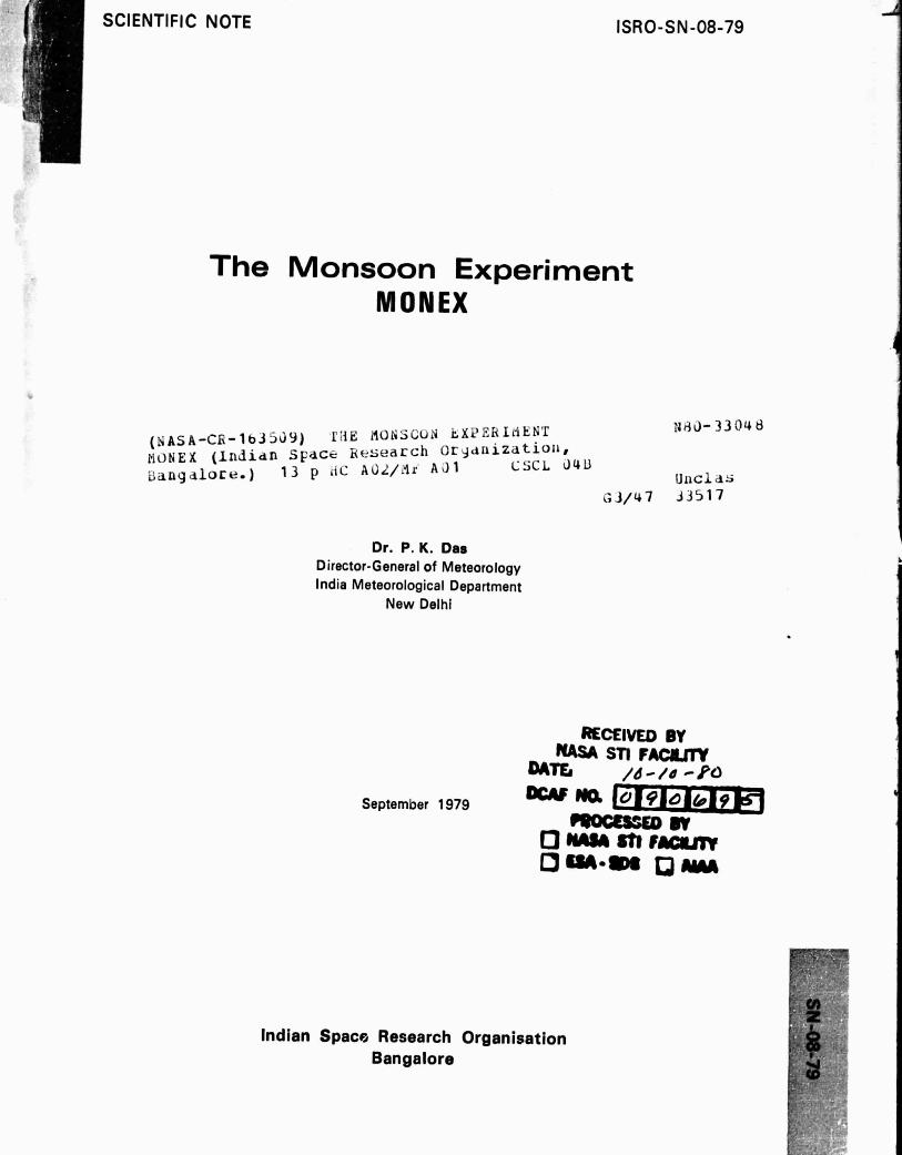
MONEX, with a similar number for the Bay of Bengal part of the experiment. The instrumented
interior of a typical aircraft for data collection is shown in Figure 3.
Figure 3 : The instrumented interior of a typical auuaft for data collection.
The Indian ships were equipped, for the first time, to measure upper winds. This was achieved with
the help of balloon-borne Omegasondes. It used a system based on the intersection of radio beams,
on very low frequencies, to monitor the track of a balloon which, in turn, provided a measure of the
speed and direction of the wind. One of the ships ran into very disturbed sea. It was stationed
fairly near to a cyclone which later struck the coast of Andhra Pradesh. Observations were recorded
with much difficulty.
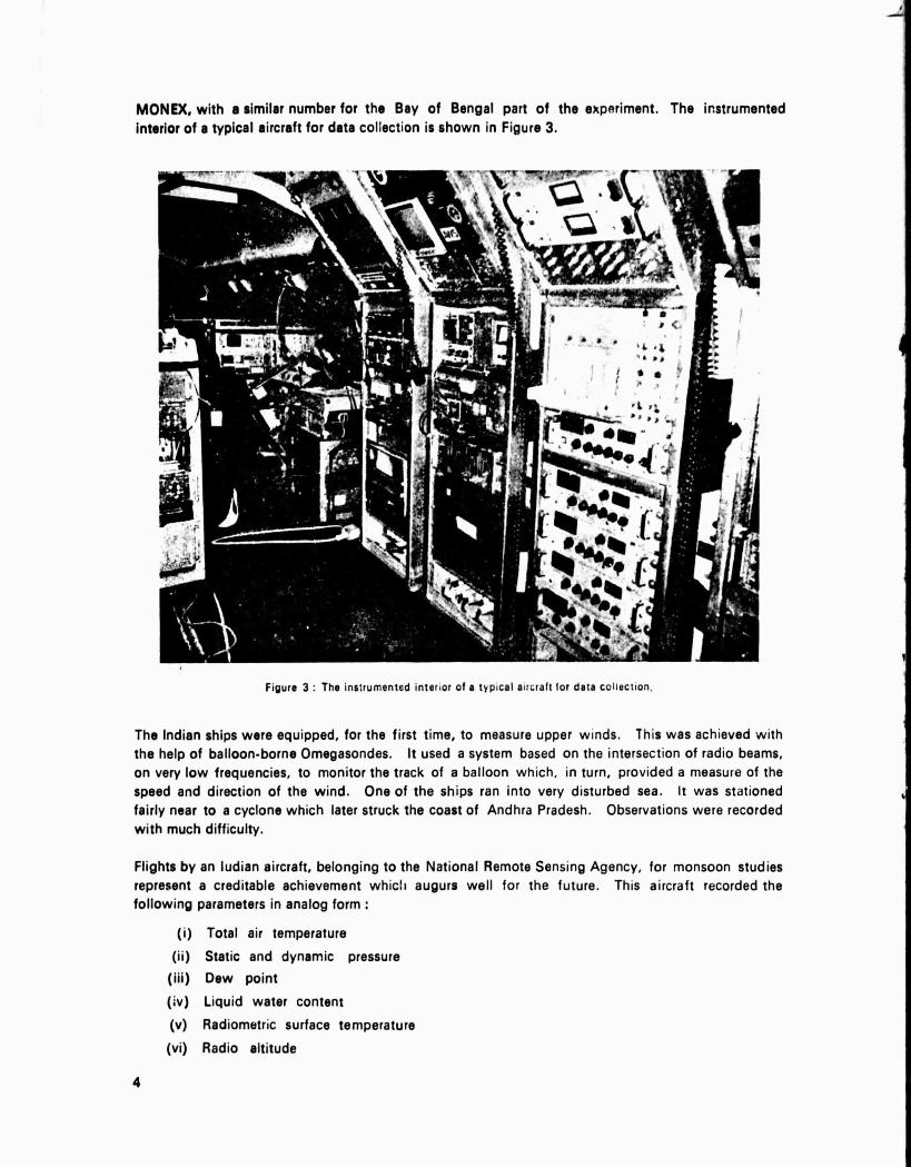
Flights by an ludian aircraft, belonging to the National Remote Sensing Agency, for monsoon studies
represent a creditable achievement which augurs well for the future. This aircraft recorded the
following parameters in analog form :
(i) Total air temperature
(ii) Static and dynamic pressure
(iii) Dew point
(iv) Liquid water content
(v) Radiometric surface temperature
(vi) Radio altitude
4

Some of the data were obtained under conditions o' turbulent and disturbed weather, associated
with depressions and tropical cyclones. These observations owe a good deal to the skill and
courage of the aircraft crew. Typical flight tracks of all the aircraft (US and Indian) taking part
soe ss 70' 75* eo"
Is F__F
2s 1
t j AV RO
' IOMDAY
ELECTRAJoAloe 10 19
17 ^^ t•
17 'IsU 12 2
1 n
^a10
CV_990
e•
s
a
NOTE % o — C-ACLtS INDICATE PoSiTiorrs orD R OF VINDS0I10E L•UMCMES
Ss 60 6s• 70• 7s• S'
Figure 4 : Flight tracks of US and Indian aircraft missions on 27 June 1979
France contributed a ship to track the path followed by the monsoon air with the help of balloons
that flew at a constant altitude. These balloons were designed to reveal the trajectory of the
air as it approached the Indian coastline during the southwest monsoon.
The observation programme of the India Meteorological Department was considerably increased and
intensified to meet the MONEX requirements. ." number of additional stations were set up to
measure upper winds, along with a network of 8 stations for measuring solar and terrestrial radiation
profiles with balloon-borne equipment
A boundary layer programme for measuring meteorological P',,ments near the earth's surface was
designed, jointly, by the Indian Institute of Science, Bangalore and the US MONEX Project. This
26 1
IS
16 1
fE
5

programme achieved a series of extremely interesting observati. -s of tht- flux of momentum, sen-
sible heat and water vapour at Digha, a coastal station near Contra in West Bengal. These
obEsrvations were made with a 10 m mast and they represent, probably for the first Jme, measure-
ments of the flux of atmospheric variables close to the earths surface under Indian conditions. A
very sensitive Lymen-alpha hygrometer was used to measur e: water vapour fluxes.
There were two other programmes which considerably enhanced the overall importance of MONEX.
The first was designed to investigate the lo,rier stratosphere with the help of rockets launched
from (i) Thumba, (ii) Sriharikota, arid (iii) Balasore, with a frequency of approximate'y one
per week. This was organised by the Indian Space Research Organisation (ISRO). The importance
of this programme arises from the fact that it will enable us to assess, probably for the first time,
the response of the stratosphere to the lower tropospheric monsoon circulation in a coordinated
manner. ne of the rocket stations was located near the equator; consequently, this programme
could be valuable for studies on the propagation of the equatorial waves in the lower stratosphere.
It is expected to continue this programme with further expansion in the near fut-ire.
The second programme was concerned with oceanography. Vertical profiles -^* ocean currents
and other oceanographic elements were measured by all ships taking part in this experiment. These
data, apart from being of interest to oceanographers •- will also interest meteorologists, because
they will provide the input for ocean-atmosphere coupled models.
Space platforms
One of the a'tractive features of MONEX was the response it generated from many countries. Several
countries agreed to intensify their national observational programmes during the operational phase of
MONEX and to communicate their data to the International MONEX Management Centre in Delhi.
Weather satellites are now capab!P of measuring an impressive array of meteorological elements.
Television cameras fitted on these satellites observe the structure of clouds beneath them and transmit
them, automatically, to a ground station located on the earth. This is referred to as an Automatic
Picture Transmission (APT) system, and the receiving point on the --aith is an APT station. A net-
work of eight APT stations was set up in India during NIONEX.
Weather satellites are of two broad types : (a) those which orbit round the earth from Pole to Pole,
and (b) those which rotate round the earth with the same speed as that of the earth round its own
axis. The latter are geostationary satellites, because they appear to be stationary with respect to the
earth. The geostationary satellites have the adviintage of being able to monitor, continuously, any part
of the earth's surface round the clock.
A beginning towards reception of data from the geostationi ry satellites was made during MONEX. A
geostationary satellite—GOES INDIAN OCEAN--was specially moved to a location on the equator at
60° E to cover the MONEX region. Clor , ds and cloud clusters observed by GOES were beamed
towards Bombay by another ge ,)stationary satellite, METEOSAT, which was iaunchcd earlier by
the European Space Agency. Cloud imagery from GOES •were first received at Lannion in southern
France, and thence transmitted to METEOSAT for onward cornrnun;cation to Bombay. Ground
reception facilities were set up at Bombay for this purpo,u. One of the pictures received at Bombay
during the early phase of the monsoon is shown in Figure 5. The clarity of the :nd;an land
mass is remarkable. Facilities were also provided at Dacca in Bangladesh for receiving cloud
images from another geostationary satellite launched by J man. Collaboration between India and
Bangladesh thus provided us with satellite coverage for b th the western and the eastern sectors of
the MONEX region
6

Sclentific objectives
MONEX was an exercise at one-time data collection. The greatest value of this experiment lies
in the expectation that it would reveal those features of the monsoon, which we need to monitor
every year for anticipating its performance. The prolonged drought in the current monsoon has
once again emphasized the importance of long range prediction of monsoon rainfall. There are
three facets on which we require Immediate improvement in our prediction capability. They are :
(i) an indication of the likely dates of onset and withdrawal of the monsoon over different
parts of the country,
(ii) a forecast of the total quantum of monsoon rainfall during ttie hundred-day period from
beginning of Jrrne to mid-SeptemLar,
(iii) likely periods o'i either heavy or lean rainfall leading to floods or droughts during the
monsoon s.;ason.
There are several impnrtant -rop y in our country, which a:a grown in areas that depend critically
on rainfall. Faddy Is an example, because the maid rice producing regions are rainfall dependent ;
consequently, an indication of the monsoon features, which we have enumerated above, are important
for the periods just prior to sowing, transplantation, and, finally, the harvest.
There are fairly well identified lines on which research could immediately commence Jter the
MONEX deta become available. One of them is concerned with the earth-atmosphere radiation
balance. There is a delicate balance between the total energy which w9 receive by way of solar
radiation, and the radiation that is lost to space from the gaseous envelope that surrounds the earth.
,: ZWaI 00117-.a 4 ' 1^•1iYZ
Figure b. Sate l lite P i s-ture rucvrvert Uri M„ 1(, 15%J
IS

70 75° E-125°N
A Fie E
,--W'BOMBAY
2Q °NI
Recent satellite data reveal, for example, that the excess or deficiency of incoming solar radiation
over the amount which the atmosphere loses to space is unly of the order of 50 watts per square
metre. Regions of excess in radiation show ivide variations from year to year. It is possible that
the p--formance of the monsoon is linked to this pattern of radiation balance over the MONEX
region The MONEX data could be utilised to study this linkage.
One way of investigating this aspect will depend on modelling experiments. Such experiments are
designed to simulate the monsoon in all its facets by a mathematical model. I f we begin with an
initial state, albeit hypothetical, we could, with the help of an electronic computer, identify those
features of the atmosphere which help to generate the monsoon. The mod:; could help us !o
ascertain, in quantitative terms, what would be the response of the monsoon if some of these
features, such as the input of solar radiation, was either increased or decreased.
It is a fairly well-known fact that the atmosphere is a highly turbulent medium in which a number
of waves on different scales of motion are hurtling round the earth. How do these waves interact
with each other to generate the weather oroducing systems, such as the monsoon depressions and
the tropical cyclones ? The accurate wind data, coupled with information on the thermdl structure of
the atmosphere, would help meteorologists in India to understand these physical processes, The
data collected by the Indian, research aircra f t have shown that the monsoon depressions in the
north Bay of Bengal are often generated in region of strong thermal contrast. Hitherto, it
was widely believed that these depressions were merely cyclonic vortices ernitted in regions of
//Zz
hg,,re 6 : Winds observed around a mid-Lopospheric love by ilia Indian aucrah
8

weak or no thermal contrast, but recent aircraft data suggest a temperature gradient of 6-8^ C over
a distance of 500 km. The interaction between the thermal and wind fields raises several interest-
ing possibiliitias, which have a bearing on the genesis of the monsoon depressions.
Short term changes in the monsoon rainfall are mainly the result of : (i) depressions in the Bay of
Bengal, (ii) mid-tropospheric low pressure system over Gujarat, and (iii) the north-south movement
of an elongated low pressure zone over the Gangetic zore, known as the monsoon trough. By
way of an illustration, we indicate the winds that were observed around a mid-t ropospheric low
by the Indian aircraft during one of its flights (Figure 6). We could not have acquired such data
over a small region by conventional means. The MONEX data will help us to identify these
systems with much greater accuracy.
There is an increasing realisation that in addition to features of regional interest, such as the
depressions and vortices of small dimensions, the monsoon is a much larger phenomenw-, which
makes a big impact on the global circulation of the atmosphere. Observations are beginning to
emerge which suggest that a lean monsoon over India is often balanced by abundant rainfall
in some other parts of the world or vice-versa. Hitherto, we had envisaged the global circulation
of the atmosphere in terms of Hadley or anti-Hadley cells . These cells were either driven by an
excess of radiation near the equator, or at mid-latitudes by the rotation of the earth. It has
been conjectured that there exist large-scale circulations of another type, oriented in an east-'west
direction which are perpendicular to the Hadley and anti-Hadley cells. The dynamics of these
cells is still obscure '),--cause the data for this purpose were not available, but there is t ,e interest-
ing possibhty that by monitoring the intensity c f these atmospheric circulations (east-west cells) in
other parts of the world we could anticipate the performance of the monsoon over India.
It is not too much to expect that, as a result of MONEX, our understanding of these asp9cts will
improve in the near future. The MONEX data will, we hope, enable us to ultimately improve our
capability to predict the behaviour of the monsoon. This experiment represents a significant step
towards helping the rural sector of India through better information on the changes in weather.
9