thinking planning and urbanism - ubc press · thinking, planning and urbanism / beth moore milroy....
TRANSCRIPT

Thinking Planning and Urbanism
moore_milroy.indd 1 11/06/2009 11:53:35 AM

moore_milroy.indd 2 11/06/2009 11:53:35 AM

Thinking Planning and Urbanism
B e T h M o o r e M i l r oy
moore_milroy.indd 3 11/06/2009 11:53:35 AM

© UBC Press 2009
All rights reserved. No part of this publication may be reproduced, stored in a retrieval system, or transmitted, in any form or by any means, without prior written permission of the publisher, or, in Canada, in the case of photocopying or other reprographic copying, a licence from Access Copyright (Canadian Copyright Licensing Agency), www.accesscopyright.ca.
17 16 15 14 13 12 11 10 09 5 4 3 2 1
Printed in Canada with vegetable-based inks on paper that is processed chlorine- and acid-free.
Library and Archives Canada Cataloguing in Publication
Milroy, Beth Moore, 1940-Thinking, planning and urbanism / Beth Moore Milroy.
Includes bibliographical references and index.ISBN 978-0-7748-1614-4
1. City planning – Ontario – Toronto. 2. Sociology, Urban – Ontario – Toronto.I. Title.
HT178.C22T67 2009 307.1’21609713541 C2009-902736-4
UBC Press gratefully acknowledges the financial support for our publishing program of the Government of Canada through the Book Publishing Industry Development Program (BPIDP), and of the Canada Council for the Arts, and the British Columbia Arts Council.
This book has been published with the help of a grant from the Canadian Federation for the Humanities and Social Sciences, through the Aid to Scholarly Publications Programme, using funds provided by the Social Sciences and Humanities Research Council of Canada.
UBC PressThe University of British Columbia2029 West MallVancouver, BC V6T 1Z2 604-822-5959 / Fax: 604-822-6083www.ubcpress.ca
moore_milroy.indd 4 11/06/2009 11:53:35 AM

The true story lies among the other stories ... M a r g a r e t a t w o o d ,
“ t r u e S t o r i e S ”
moore_milroy.indd 5 11/06/2009 11:53:35 AM

moore_milroy.indd 6 11/06/2009 11:53:35 AM

Contents
List of Illustrations / ix
Acknowledgments / xi
Abbreviations / xiii
1 Opening / 1
2 History / 42
(with Nik Luka)
3 Regenerating / 67
4 Redeveloping / 98
5 Defending / 138
6 Implementing / 180
7 Closing / 217
Appendix 1 Selected elements of the planning framework / 238
Appendix 2 Chronology / 250
Appendix 3 Basic characteristics of the planning area / 254
Appendix 4 Socioeconomic information about the planning area / 257
moore_milroy.indd 7 11/06/2009 11:53:35 AM

viii Contents
Appendix 5 Seven development options, Yonge and Dundas area,
December 1996 / 260
Appendix 6 Financial plan and costing scenarios, Yonge and Dundas
area, December 1996 / 262
Appendix 7 Issues raised at public meetings and via correspondence
regarding the redevelopment scheme, spring 1997 / 266
Appendix 8 Bylaws before the Joint Board / 269
Appendix 9 Decision of the Joint Board: Jurisdiction, conclusions and
findings, decision and conditions, and obiter dicta / 271
Appendix 10 Sample calendar of events at Nathan Phillips Square
January to July 2000 / 280
Notes / 282
References / 293
Index / 308
moore_milroy.indd 8 11/06/2009 11:53:35 AM

list of illustrations
Figures
1.1 Toronto in its North American context / 3
1.2 Toronto in its regional context / 4
1.3 Selected subareas of the City of Toronto’s core / 5
1.4 Southeast corner of Yonge and Dundas, 1998 / 6
1.5 Northeast corner of Yonge and Dundas, 1998 / 6
1.6 Looking southeast down Yonge Street, 1998 / 7
1.7 Yonge and Dundas’ new image, 2007 / 7
1.8 Dundas Square, formally named Toronto Life Square, 2008 / 8
2.1 The Toronto Plant of the T. Eaton Co., c. 1919 / 48
2.2 Yonge Street as a boulevard in front of Eaton’s College Street store,
c. 2008 / 48
2.3 Yonge Street Strip, 1975 / 53
2.4 Yonge Street as pedestrian mall, 1974 / 54
2.5 Toronto Eaton Centre interior, 2008 / 58
2.6 Plan to connect Dundas Street West and East / 63
3.1 HMV’s “urban box” form, 2005 / 72
3.2 Looking south on Yonge Street, 1999 / 78
3.3 Reinvestment area and larger community improvement area / 80
3.4 Yonge Street’s built-form context, 1996 / 83
4.1 Development parcels, Yonge Dundas Redevelopment Project / 108
4.2 Original illustration for the redevelopment of the Yonge-Dundas area,
1998 / 109
moore_milroy.indd 9 11/06/2009 11:53:35 AM

x list of illustrations
4.3 Conceptual drawing of the future square and surroundings, 1997 / 110
5.1 Looking south down Yonge Street to Lake Ontario / 147
6.1 Salvation Army building and the Senator, 1998 / 185
6.2 Original design of the Torch, 1999 / 187
6.3 The Torch, 2008 / 188
6.4 Dundas Square, winning design, 1998 / 191
6.5 Triangular sidewalk outside the Eaton Centre, 1999 / 200
6.6 Reduced sidewalk outside the Eaton Centre, 2008 / 200
6.7 Downtown Yonge Business Improvement Area boundaries, 2001 / 202
6.8 Chess players on Gould Street, 1999 / 211
Tables
4.1 Number of police “contact events,” 1995-97 / 132
4.2 Drug, prostitution, and total criminal offences, 1996 and 1997 / 133
6.1 Changing management of Dundas Square / 193
moore_milroy.indd 10 11/06/2009 11:53:35 AM

Acknowledgments
At the beginning of this project, Nik Luka was as deeply immersed in the
Yonge-Dundas material as I was. I thank him for many hours of discussion
and research devoted to trying to decide what to make of the transformation
that was taking place quite literally outside the doors of the Ryerson Univer-
sity planning school. We met at Ryerson, where I was the director of the
planning school. I had recently arrived in Toronto and was digging myself
into the local culture, while he, a Toronto-born young graduate of the plan-
ning program, was preparing to leave town. There was a fruitful period of
overlap. He subsequently went on to other intellectual pursuits, and, in the
fullness of time, the project evolved into something quite different from where
we had started. I gratefully acknowledge his early collaboration, which was
a pleasure to have had, and expressly add that he bears no responsibility
whatever for any judgments, errors, or omissions in the final text.
It was a great help to have been invited to discuss the project with under-
graduate and master’s students in several programs at Ryerson University and
the University of Toronto and in doctoral seminars at the University of To-
ronto and the Università di Roma Tre. As I prepared for each of these events,
my rising level of anxiety about how I would be able to simply and suc-
cinctly say what seemed only complicated and unyielding to abbreviation had
a way of focusing the mind, as the expression goes. I thank all who partici-
pated in debating why with me at these events. My ideas were also sharpened
along the way thanks to exchanges with Heather Campbell, Philippa Campsie,
Brendan Cormier, Frances Frisken, Neil Harris, Michael Neuman, Lucia Nucci,
Giorgio Piccinato, Katharine Rankin, Scott Rodgers, Yvonne Rydin, Huw
Thomas, and several anonymous referees who critically read versions of the
manuscript. I sincerely thank them all for their insightful comments. A special
thank you also goes to Luigi Mazza for several conversations that contributed
moore_milroy.indd 11 11/06/2009 11:53:35 AM

xii Acknowledgments
to this project, all of which took place during delightful periodic walkabouts
in various European and North American cities.
Because of the location and nature of the project, it needed little funding.
However, I was glad to have received several small grants that I used to hire
occasional research assistants and specialized professional services and to
travel to academic meetings in France, England, and the United States to
discuss the work as it progressed. For this most welcome assistance, I thank
Ryerson University and, in particular, the Faculty of Community Services.
I was often given assistance in timely and important ways by friends, col-
leagues, assistants, and strangers regarding materials used in the writing of
this book. Many thanks go to all of them, including, but not limited to, the
following: Judith Bell, Louise Berthiaume, Scéno Plus, Montreal; Carys Craig;
Elizabeth Cuthbertson, City of Toronto; Paula Gallo; Carolyn Gray, senior
copyright advisor, Service Ontario Publications; Gordon Grice, Gordon Grice
and Associates, Toronto; Sherrill Rand Harrison, Mahone Bay, Nova Scotia;
Ian Lord, Weir & Foulds, Toronto; James Robinson, Downtown Yonge Busi-
ness Improvement Area; Zack Taylor; Cheryn Toun, City of Toronto; Stephen
Waqué, Toronto, for permission to quote from “Notes on argument in chief
by the City of Toronto,” 1998; and Richard White.
Finally, my very special appreciation goes to Barbara, Louis, and Jessica,
who lovingly and continuously share so much with me, including their ap-
petite for ideas and learning.
moore_milroy.indd 12 11/06/2009 11:53:35 AM

Abbreviations
BIA business improvement area
BID business improvement district
CCTV closed circuit television
CIP community improvement project
DYBIA Downtown Yonge Business Improvement Area
DTYS Downtown Yonge Street
GDRA Garden District Residents Association
OMB Ontario Municipal Board
OPA official plan amendment
PPP public-private partnership
RFP request for proposals
RFQ request for qualifications
TEDNA Toronto East Downtown Neighbourhood Association;
Toronto East Downtown Neighbourhood Alliance
TEDRA Toronto East Downtown Residents Association
TTC Toronto Transit Commission
UDC urban development corporation
UDP urban development project
UEC urban entertainment centre
YSBRA Yonge Street Business and Residents Association
YSM Yonge Street Mission
moore_milroy.indd 13 11/06/2009 11:53:35 AM

moore_milroy.indd 14 11/06/2009 11:53:35 AM

Thinking Planning and Urbanism
moore_milroy.indd 15 11/06/2009 11:53:35 AM

moore_milroy.indd 16 11/06/2009 11:53:35 AM

CHaPter 1
opening
On one level, this book is about how planners and others puzzled over what
to do with a small downtown area in Toronto and the eventual outcome, a
redevelopment intended to mimic New York’s Times Square and London’s
Leicester Square. It is a story of planners at work on a difficult issue in per-
plexing times, and it is described in detail from conceptualization to imple-
mentation to show precisely how planning was practised. On another level,
this case is paradigmatic of planning problems encountered in a broad spec-
trum of urban areas where pressures of contemporary urbanism are felt. These
pressures include the problem of how to pump new value into small areas
when conventional assumptions about the relationship between an urban
core and its periphery no longer obtain. For example, one outdated assump-
tion is that the core provides essential services for its periphery; another is
that “urbanness” is measured by population density rather than electronic and
other exchanges. At this second level, the book grapples with the adequacy
of the theories planners use to inform their work on a planned intervention
such as this.
The powers and forces configuring urban areas today are considerably differ-
ent from those associated with the industrial revolution of the mid-nineteenth
to mid-twentieth centuries. Many attribute current changes primarily to global-
izing economies and concomitant social conditions. While these forces are
undoubtedly major contributors, the context in which this case study unfolds
points at least as much to technology as a driver of contemporary urban form.
The urban and regional planning field has tended to be less cognizant of
technology’s significance to the evolution of urban form, except as a deriva-
tive of economic and social revolutions.1 Transportation and communications
technology in particular add specific capacities to urban development, such
as being able to spread out over enormous areas while still enabling people
moore_milroy.indd 1 11/06/2009 11:53:35 AM

2 opening
to be connected at any time to anywhere else. How to deal with the diffuse
settlement patterns made possible by the combination of technological, social,
and economic changes is a major question. A complementary question is how
to treat the holes that are left, or made, in contemporary urban space by
expansive development. Together, these questions call for a new form of
urbanity, of conviviality, and for a reciprocal readjustment between the form
of the urban tissue and the forms of engaging with each other.2
The story is about a specific type of small core area space and the argu-
ments for conceptualizing the space in particular ways. Throughout city his-
tory, such debates have been common. In this instance, there is an unusual
opportunity to examine the discussions in detail because the city’s planning
department put forward two proposed solutions concerning the same site,
each of which was dominated by a dramatically different conceptualization
of space. In the first proposal, the aesthetics of space, such as perspective
and proportionality, and its technical features, such as sunlight and relative
location of things, carried considerable weight. In the second proposal, space
was conceptualized as nothing in and of itself but instead as what can be
created out of it by people who seek to use the space to advance their goals,
be they economic, social, or political. That is, the dominant conceptualization
of the second proposal is that space is produced through social relations.
Seeing the two proposals side by side sharpens the distinction between
technical-aesthetic and socioeconomic conceptions of space and prompts
questions about how the two inform theories and practices of planning.
As a point of departure, I accept that both the technical-aesthetic and socio-
economic conceptualizations of space are properly part of urbanism and
urban planning. This study explores a case in which the tension between
the two understandings of space was lost. When the second proposal was
implemented, a model from elsewhere that was expected to solve social
and economic problems was set down in the city core in a location defined
as a suitable receptacle for the proposed treatment. Scholars have analyzed
comparable projects, using social science–based urban theories to uncover
how and why such projects were developed. While recognizing their insights,
I have approached this case differently, immersing myself in its dense detail
to see what questions it raised about planning and urbanism. The manner
of conceptualizing space emerged as a central issue. It shaped the propos-
als of planning practitioners, and it either opened up or closed down the
potential for innovation. The proposals are classic illustrations of how to treat
space, each with centuries of urbanistic practice behind them. I consider
the implications of these conceptualizations of urban space for theorizing
planning.
moore_milroy.indd 2 11/06/2009 11:53:35 AM

3opening
The Story in a Nutshell
The area in question is in the vicinity of the intersection of Yonge and Dun-
das streets in downtown Toronto. (See Figures 1.1 and 1.2 to locate Toronto
in its North American and regional contexts and Figure 1.3 for selected sub-
areas of the city’s core, which is where the case takes place. See Appendix 3
for a written description of the area.) For years people had noted the absence
of redevelopment money going into the ten or so blocks in the vicinity of the
intersection. Some said redevelopment was not happening because the area
C A N A D AU S A
OntarioQuebec
Montreal
Ottawa
Detroit
Chicago
Boston
New York
Atlanta
Washington, DC
Miami
Houston
TORONTO
Halifax
500 km (300 miles)
1000 km (600 miles)
1500 km (900 miles)C A N A D A
KEYAREA
U S A
1.1 Toronto in its North American context. | Adapted from Toronto (1992, 113).
moore_milroy.indd 3 11/06/2009 11:53:36 AM

4 opening
was so down-at-the-heel; others argued the reverse – that it was down-at-
the-heel because the land use restrictions in the city’s official plan discouraged
redevelopment. Whatever the cause, the area was in poorer condition than
civic authorities and a wide range of other people thought appropriate. After
all, this was reputedly the busiest corner in the country and the location of
the main door of the Eaton Centre shopping mall, which is said to have the
highest turnover retail sales space in Canada. It was widely agreed that a
planned solution was needed. Efforts made to fix up the area over more than
two decades were judged to have had little effect.
1.2 Toronto in its regional context. Aside from the City of Toronto, only upper-tier municipal boundaries – counties and regional municipalities prior to amalgamation – are shown. | Adapted from Toronto (1992, 113).
moore_milroy.indd 4 11/06/2009 11:53:36 AM

5opening
For decades there has been hand wringing over the Yonge Street Strip. Older
adults have worried about its influence on their children at least since hippie
youths hung out there in the 1970s, followed by punk youths in the 1980s
and hip-hop youths in the 1990s, always with a certain amount of drug use
and trade happening. From the early ’90s, the picture also included increased
numbers of students at Ryerson University a block away; two youth shelters
and a shelter for homeless men within two blocks of the intersection; increased
numbers of psychiatrically disturbed people wandering around because de-
institutionalization policies were not matched by community care; more
homeless people because senior government funding for all social housing
programs had been stopped; and more panhandling and loitering than had
likely been seen in Toronto since the 1930s because welfare provisions had
been cut by more than 20 percent on top of a deep five-year recession, which
brought high unemployment rates, particularly for young people. By the mid-
1990s Yonge-Dundas looked very stressed, certainly to middle-class eyes. (See
Figures 1.4 to 1.8 for before and after views of the Yonge-Dundas area.)
1.3 Selected subareas of the City of Toronto’s core. | Adapted from Toronto (1990b, 16) and Toronto (1994c,
Map M.2)
moore_milroy.indd 5 11/06/2009 11:53:36 AM

6 opening
1.4 The World’s Biggest Jean Store on the southeast corner of yonge and Dundas, 1998. | Author’s collection.
1.5 Stores on the northeast corner of yonge and Dundas, 1998. | Author’s collection.
moore_milroy.indd 6 11/06/2009 11:53:37 AM

7opening
1.6 looking southeast down yonge Street, 1998. Dundas Square Street is to the left; eaton Centre is on the extreme right. | Author’s collection.
1.7 yonge and Dundas’ new image, 2007. Dundas Square, looking west from the bandstand to eaton Centre with its media tower. | Author’s collection.
moore_milroy.indd 7 11/06/2009 11:53:37 AM

8 opening
In 1996 two solutions were proposed: a gentle regeneration-style solution
was approved but was superseded nine months later by a dramatic expropriate-
and-redevelop proposal. The latter has been in the process of implementation
ever since and is the proposal that receives all of the attention. No one seems
to remember the regeneration plan. Politics had a great deal to do with the
switch from one plan to the other. Because there were two plans from the
same planning department and from some of the same planners for the same
geographic space in overlapping time periods, their foci and rationales can
be compared. In the transition from one to the other, we see the position in
which the planning department (the Planning and Development Department,
which was renamed Urban Development Services in September 1996) found
itself after having been politically forced to reassess its first, gentler strategy.
The routes open to the planning department seemed to be as follows: (1) to
refuse the new, more aggressive model and be sidelined while the planning
framework was operated without the planning department; (2) to strongly
make a case for why the new approach was wrong and then, if the city
1.8 looking south over Dundas Square, formally named Toronto life Square, on a sunny Sunday afternoon in May 2008. hard rock Cafe is just off the square on the right. Financial district towers are in the background. | Courtesy of Sherrill rand harrison.
moore_milroy.indd 8 11/06/2009 11:53:37 AM

9opening
council still insisted on going ahead, to do the best planning job possible by
trying to avoid the worst outcomes; or (3) to be persuaded to go ahead with
it, either because the department saw no alternative or because the second
proposal was the better strategy. Regardless of whether it was in its better
judgment, the planning department took the third route, at least publicly.
Because it chose the third alternative, the planning department had to for-
mally defend it when an appeal was launched.
Planning was central in this case and, indeed, a battleground for political
struggles. In one struggle, planners were pitted against planners: the city used
in-house and contract planners and a coalition of area business interests to
oppose another set of business interests equipped with its own contract plan-
ners, economists, and land evaluation experts. In another struggle, certain
interests were trying to shift the role of planning in Toronto. The justifications
the city gave for its change from regeneration to redevelopment, and for its
preference for its own plans over those proposed by opponents, provide
some evidence for the hypothesis that planning in Toronto was being nudged
toward an entrepreneurial approach, that is, to inviting the private sector to
lead redevelopment initiatives and reap the rewards of property value in-
creases.3 This contrasted sharply with conventional planning approaches in
Toronto, including the predecessor plan for Yonge-Dundas. Using Brindley,
Rydin, and Stoker’s (1989, 11) terms of analysis, the regeneration plan could
be described as a mix of regulative and trend approaches, that is, managing
urban development in the public interest while using a few tools to entice
the market to deliver what it was more or less ready to offer anyway. As for
the redevelopment approach, the term “entrepreneurial” does indeed describe
it. The project site was turned over to private-sector redevelopment interests
to make Toronto more competitive in comparison to other cities; processes
were largely kept away from public scrutiny, and the so-called public square
ended up promoting private consumption. A decade later we can see that
entrepreneurial planning like this has not taken over in Toronto but, like
elsewhere, has become one style among several that a city may employ. As
an approach, entrepreneurial planning is likely to produce repetitious rather
than distinctive environments (see Hall 2002, chap. 11; Loukaitou-Sideris and
Banerjee 1998, 292) and, thus, less competitiveness (Hanna and Walton-
Roberts 2004). However, beyond the matter of planning styles, there is now
an overall greater propensity than there was in the mid-1990s to use more
entrepreneurial attitudes, actions, and language (Courchene and Telmer 1998;
Laxer 1995); to seek to criminalize or ostracize poverty (Gordon 2004; Kipfer
and Keil 2002); and to use mixed public-private ventures to carry out a variety
of municipal activities by various means, as has been seen in many other
moore_milroy.indd 9 11/06/2009 11:53:37 AM

10 opening
cities (e.g., DeFilippis 1997; Eisinger 2000; Gómez 1998; Gómez and Gonzá-
lez 2001; Hagen Hodgson 1997; Hoyt 2003; McGuirk and MacLaran 2001;
Plaza 1999, 2008; Waitt 1999; Williams 2003; Winter and Brooke 1993).
What kind of reasoning went into justifying the second project? Some of it
was sound and appropriate, but much was fallacious (appeals to emotion
were used, symptoms and root problems were elided, solutions used elsewhere
were parroted), and much was post hoc rationalizing with a view to obtaining
approval for a project that proponents wanted, regardless of whether there
was evidence to support it. As was the case in Bent Flyvbjerg’s (1998) Danish
example, rationality took the form of Realrationalität, that is, rationality prac-
tised in the face of power.
One of the fallouts from this entrepreneurial example concerned the com-
mons, which shrank because public space was turned over for private inter-
ests to shape. The use of the term “public space” assumes that it is useful to
define space along a public-private axis, even though meanings will be
specific to cultures and historical periods (Lofland 1998, 8). Not all public
spaces have the same level of publicness. The most public of spaces are
owned by governments and are expected to remain open for public discus-
sion and political expression; traditionally, these are streets, sidewalks, parks,
and squares. Other forums, such as community centres, libraries, universities,
subways, and airports, may have constraints on their use that do not apply
to traditional public spaces. Dina Graser’s (2000, 70) assessment of a govern-
ment’s relationship to public space in the Canadian legal framework is that it
is quasi-fiduciary, which means that governments “have a responsibility not
to unduly restrict freedom of speech in public spaces” and “a corresponding
obligation ... to ensure a right of access for this purpose as an essential part
of a functioning democracy.” In this view, traditional public spaces are places
where political activity may be expected, not places to be protected from
politics (Deutsche 1996, 283). They are places where those people whose
behaviour – sleeping on the street or panhandling – may disrupt a notion of
urban order have a rightful place, along with anyone else who may, when
encountering them on the street, be reminded of the political fact that their
government appears to be failing some of its citizens.4 In the Yonge-Dundas
area, some of the merchants set up a so-called public-private partnership with
the city to mastermind redevelopment of the street. Subsequently, the city
created a board dominated by active proponents of the redevelopment to run
the square, and a new privately managed Business Improvement Area was
established in accordance with provincial regulations to look after the sur-
roundings. It treats the street rather like a mall, so the street’s character changed
from political to economic (Graser 2000, 68-69). The actual street, not simply
moore_milroy.indd 10 11/06/2009 11:53:37 AM

11opening
its uses, was commercialized with the assistance of the city and the province.
The conventional idea of a street was challenged, as was the idea of the city
square. Private security services were procured for the square, and the new
board sought to sell the “public” square to paying users. The administrative
set-up of the square is, therefore, contrary to the grounds upon which the
city approved the development and defended it in a legal wrangle. The degree
to which this development increased cynicism about the commons cannot be
gauged.
The unstated goal of the Yonge-Dundas redevelopment was to increase
consumer spending in the area. All imagery was directed to that aim via
spectacularization – passive watching and being in the presence of spectacles.
Huge lighted screens hang on almost every surface around the square, ad-
vertising products, services, and lifestyles. Spectacular events periodically fill
the square to boost consumption: Sir Richard Branson sliding down a wire
from the Olympic Torch into the square to launch his newest Virgin product;
the World’s Biggest Stir Fry to promote Arctic Gardens food products; a world-
record-seeking, chocolate-milk-chugging contest to advertise Grab, Gulp, and
Go from Nestlé.5 Consumption is an individualized activity for the consumer
and a privatized activity for the provider. When streets and squares are de-
signed to serve individual and private activities, the conventional assumptions
of the public-private axis are completely altered. Part of the unwritten social
contract has been revised – without taking a vote. This is why it is important
to pay attention to the transformation that occurred with the help of the plan-
ning framework.6 Civic place making, as Peter Rowe (1997) describes it, re-
quires both publicness for democratic reasons and aesthetic appeal for a wide
range of people. Together, the socioeconomic and technical-aesthetic can
make a civic place. Torontonians learned not to take for granted that their
civic government would use its property to make a civic place.
A stated goal of the redevelopment phase was to increase the variety of
people using the area; however, the mix was already astonishing. In fact, the
project was designed to flatten the mix to a particular consumer stratum. It is
difficult to avoid the conclusion that the stated goal was code for increasing
the number of people with disposable incomes and discouraging the presence
of loiterers, indigents, and those working in the underground economy.7 Since
no survey was done of who was using the area, the outcome of this large
intervention can never be evaluated from the point of view of its often-stated
goal. Indeed, despite all the money spent on costly contract planners, expro-
priation lawyers, land economists, disturbance damage experts, quantity
surveyors, tax experts, signage rights specialists, and square naming experts,
no one asked what that goal meant and whether physical redevelopment
moore_milroy.indd 11 11/06/2009 11:53:37 AM

12 opening
would achieve it, let alone whether it was the best way to achieve it. The
opponents’ counsel in a quasi-judicial hearing into the need for expropriations
to accommodate this project was the only person who tried to show why that
goal was not achievable via the chosen means.
It is unclear how success should be measured in this case. Were planners
guided by public or private interests? When it comes to planning actions on
the ground, is the putative division of public and private interests even useful?
If the area attracts new international chain retail outlets as was expressly
desired by the project planners, along with family shoppers whom the ward
councillor wanted to see there, and tourists who were the hope of busi-
nesses in the area, then some will take those results as signs that the redevel-
opment worked. And if the dollar stores, drugs, and homeless people move
elsewhere in the downtown area, by what measure would these city-owned
issues have been solved? Has the public interest been served?8 Or, how does
one measure Torontonians’ sense of having been duped when it is found that
the public square is managed first and foremost for commercial interests? How
can this venture be evaluated when the cost to the city can never be known,
at least from outside the bureaucracy? Many of the documents necessary to
make that assessment were purged from public files on the ground of confi-
dentiality. The idea of planning as an activity that serves the public interest
is severely tested in this case. To what extent was society improved by these
activities?
In my view, this case is not unusual. This is a study of decision making and
action as planners often experience them – as struggles over who controls
decisions, investment opportunities, and symbols in a city’s core. Planners
were working on a difficult problem and, in this instance, in a very difficult
context. The planning of Yonge-Dundas took place at a time when the city
was emerging from a deep recession that had lasted five years, from 1989 to
the end of 1994. In mid-1995 a newly elected provincial government came
to power on a platform – the common sense revolution – that had all the
earmarks of neoconservatism. It promised to fix Ontario’s economy via huge
tax cuts, the reduction of social programs, and the introduction of workfare
and law-and-order measures. In the course of this “revolution,” the new
government sought to reduce the number of local governments and their
range of activities, including subsidized housing and libraries (Courchene
and Telmer 1998; Ibbitson 1997). By the end of 1996, the city of Toronto was
trying to stave off legislation to force its own amalgamation with five adjacent
cities and the eradication of the metropolitan level of government, which had
been in place for forty-five years and was a model of success. The metropol-
itan government had been credited with contributing to the Toronto region’s
incorporation of rapid population growth while maintaining a healthy city
moore_milroy.indd 12 11/06/2009 11:53:37 AM

13opening
core, unlike many US cities (Frisken 2008, chap. 1; Lemon 1996, chap. 7;
Sharpe 1996). For a few months in 1997, during the later planning period for
Yonge-Dundas, the attention of city officials and Torontonians was on trying
to convince the provincial government to reverse its amalgamation plans and
a confusing series of moves designed to alter the financial responsibilities of
the municipalities and the province. Once the Toronto amalgamation was
certain to go ahead, politicians and bureaucrats began to position themselves
as best they could, because it was obvious many would lose their jobs by the
end of the year in the next civic election, when the number of elected officials
would be cut in half.
It was in the midst of unprecedented pressure by the province to amalgam-
ate voluntarily or be forcibly amalgamated, and the subsequent reorganization
of local government departments, that those involved in the Yonge-Dundas
project laboured (Frisken 2008, chap. 6; Sancton 2000). Although it was a
busy time and, consequently, there may have been some inattention, the area
around this intersection was not so different that the lessons of the case are
inapplicable to other times and places. Local government is more often than
not a tremendously busy arena, and many who, in the best of all possible
worlds, would want to give individual issues more attention are actually too
busy to do so.
Situating Contemporary Urbanized Space
In order to situate contemporary urbanized space, a quick trip through time
is necessary. Simplifying excessively, Western city formation can be envisaged
as having taken three forms, albeit with many variations, since antiquity. The
first phase is represented by the classic city, in which a person’s place of
residence and citizenship were closely correlated so that a citizen belonged
to a place. City spaces were distinguishable from rural spaces, and activities
in the two were mainly complementary. The building of cities was planned
and managed through various means, including civic governments of admin-
istrators and councils. From at least Roman times, dense population and diverse
activities have been defining features of cities.
The second phase is represented by the city of the Industrial Revolution,
which emerged with massive migrations of people from the countryside as
well as from one country to another. Out of that period of urbanization came
the new word “urbanism,” which refers to reflections on and the shaping and
managing of densely populated and dynamic urban areas. Urbanism is one
name for practices that today include urban and regional planning. The
complementarity of urban and rural ways of life changed gradually as “work”
came to be identified with employment in the cities of the new industrial
capitalism. The identification of work with the city reinforced a core-periphery
moore_milroy.indd 13 11/06/2009 11:53:37 AM

14 opening
relationship in which the city centre was the service site for its hinterland.
Built-form changes included trying to bring, for health and safety reasons,
the country into the city via gardens and open spaces and the city to the
country via low-density new towns. Although explanations for the rise of
industrial cities tend to focus on the economic and social revolutions of the
time, the argument can be made that an ongoing technological revolution in
transportation, communications, electrification, and building techniques was
just as responsible for making the industrial city possible (Ascher 2001; Choay
1994, 27-28).
The third phase – which was also spurred by the ongoing technological
revolution, especially in communications, and associated with new possibilities
for economic production and management, and for urban form – was felt by
the 1960s. Dispersion was added to urban sprawl. As in the previous phase,
settlement continued in suburbs, but it expanded well beyond them into
hinterlands that were not contiguous with urban regions. For example, in
Canada from the early 1990s a growing number of “amenity movers” chose
places that offered pleasure over economic opportunities – perhaps a slower
pace of life, ski hills, hiking trails, beaches, sailing, splendid views, or clean
air – even when these were in isolated locations (Chipeniuk 2005). The city
centre no longer provided essential services for those in the vast periphery.
The complementarity of urban and rural ways of life ceased to be the norm.
The correlation between place of residence, work, and citizenship weakened
so much that a person might live in one location, work in another, and be a
citizen elsewhere. In this “hyperurbanité,” the density of movement is more
significant than population density (Bordreuil 2000, 169). If footloose indus-
tries showed a marked increase in the earlier decades of this phase, footloose
workers – people who can choose where they work and live – have become
more common in its later decades.
There is no consensus on what to call the contemporary phase of urban-
ization, which affects people on five continents, or the type of urban form
that is being generated. The phase and the form are not separable. Regardless
of whether people live in villages or large cities, their experiences are increas-
ingly shaped by “the urban,” a kind of generalized, global urbanness. Louis
Wirth’s phrase “urbanism as a way of life” seems apt, even if his analysis does
not apply today ([1938] 1969). Names for the phase include the information
age, the network society (Castells 1996), l’urbain, l’ère de l’aménagement
reticulée (the era of networked land-use planning) (Choay 1994, 1999), and
société hypertexte (Ascher 2001). On the unanswered question of what to call
the urban areas that are situated within the broader urbanness that shapes
our way of life, Kenza Benali (2006) gives a helpful overview of the issues.
One issue is that the larger urban areas are less reliant on the state than had
moore_milroy.indd 14 11/06/2009 11:53:37 AM

15opening
been typical in the industrializing period, and they function increasingly as
cities linked together in defined ways. Eclipsing conventional metropolitan
and regional forms, terms such as système métapolis (Ascher 2001), “city-re-
gion,” “super-region” (Courchene and Telmer 1998; Jonas and Ward 2007;
Scott and Storper 2003), “polycentric metropolis,” “mega-city region,” “poly-
opolis” (Hall and Pain 2006), or “network” refer to urbanized areas that are
not necessarily contiguous and may even cross national boundaries but link
up to create a competitive edge for some product or service. Sometimes
“postindustrial city” is used, but the term has drawbacks. First, it implies a
counteraction to the industrial city. It draws attention to economic activity
rather than to the opportunities that these areas generate to innovatively
combine a range of activities across various spaces, and it hides new techno-
logical evolution. Second, the term retains the word “city,” which is a problem
given that the complementarity of city-not city has been severed, as has the
connection between territory and citizenship that was a hallmark of the clas-
sic city. “Urban” is more dynamic, less bounded than “city.” To be sure, “city”
will continue to be used, but its users are on notice that the term can obscure
as much as it reveals. In effect, the meaning of centrality as it concerns urban
space is being redefined (Sassen 2001).
Analyses of contemporary urban areas show that the geographic expansive-
ness made possible by technological innovations and the ability to plug in
more or less anywhere and anytime have had disparate effects on core areas.
Some urban areas – the larger, more globally connected – thrive more than
ever but with disparities in income and opportunities that are alarming in
some cases, less so in others (Fainstein 2001b). Middle-scale cities (population
about 100,000 to 500,000) struggle against the odds to keep a vibrant core
(Filion et al. 2004), while the cores of smaller cities may be emptied of retail
and other economic activities that disappear or relocate to the outskirts, where
taxes are lower and access by private vehicles is simpler. All of these develop-
ments require finding ways to reuse city cores because the newly emerging
urbanity brings different conditions but does not annihilate all physical signs
of previous ones. The centres of older cities, some of which predate the
Industrial Revolution, concretely propose forms for living and working in
close proximity. There are lessons to be learned about built form in those
spaces. What techniques can be used to adapt these spaces while opening
the city to innovative activities? What techniques can be applied to ensure
the pleasure of face-to-face communication and built form that respects the
physical features of proportionality, patterns, coherence, and so on, continues?
How can one best use existing patterns, generate extensions, fill holes, or
bridge the space between A and B? Retrofitting is essential because the use
of the core must change when a centre is no longer the service centre to its
moore_milroy.indd 15 11/06/2009 11:53:37 AM

16 opening
periphery. Ongoing innovation and ingenuity are demanded in the practices
of urbanism.
This description of contemporary urban form connects to the book’s case
study in the next chapter, which describes the development of the core dur-
ing the industrializing period and the onset of uncertainty when the effects
of rapid suburbanization begin to alter the core in the late 1950s. Later chap-
ters describe the two proposed treatments that were developed in the mid-
1990s. By that decade, the proposals represented different responses to how
Toronto’s core had gradually changed in relationship to the rest of the region
and, more immediately, was changing under the pressure of economic reces-
sion and increased social problems. These changes were associated with
broader international conditions affecting Canada’s economy that had specif-
ic effects in downtown Toronto via national, provincial, regional, and metro-
politan policies, as would be the case in any location (see Donald 2002a,
2002b; Gertler 2001; Gertler et al. 2000).
Structure of Planning: Activities, Planners, and Frameworks
Planning is often called an art, a science, or a discipline. In my view, planning
is a field of practice in which people reflect on and suggest how to shape
and manage an area that is jurisdictionally defined. Urban areas are prime
examples. A field of practice brings knowledge and skills together with ideas
about better and worse ways to act, given the conditions the practitioner faces.
Planning is but one of the fields of practice engaged in urbanism. A field of
practice differs from a “discipline,” which is a term applied mainly by people
in educational circles to the sciences (social, physical, and biological) and
humanities. A discipline is an area of investigation, the purpose of which is
to better understand the subject matter, not to try to treat it. For instance,
geomorphology is a discipline devoted to studying the earth’s surface. The
discipline’s scholars seek to better understand the origins and transformations
of the surface of the earth to better predict outcomes or explain effects, not
to change the earth’s surface.
Brendan Gleeson’s (2003, 765) straightforward view of public planning
activity is that it takes three forms:
1 development control centring on the regulation of land uses and built environ-
ments at the local scale;
2 assessment of environmental and social impacts of proposed development
activity at the local and regional scales;
3 strategic planning involving the coordination of public and private investment
and of government regulation within particular spatial frames.
moore_milroy.indd 16 11/06/2009 11:53:37 AM

17opening
Strategic planning includes generating planning policies that may appear in
various forms such as in official, strategic, and subarea plans. These policies
are future-oriented, spelling out actions needed in the short to medium term
to serve needs but simultaneously safeguarding opportunities for the long
term. Planning is more than land use regulation: it is more akin to inten-
tional interventions to influence land and building development (see, e.g.,
Brindley, Rydin, and Stoker 1989; Tiesdell and Allmendinger 2005). These
planning activities are carried out by conducting studies and having discus-
sions with those concerned about matters relevant to land and building
development.
To put some boundaries around planning, it is useful to note that not all
urban development outcomes are the results of formal planning. In some
cases planners recommend X, but Y is done; in others, no recommendation
is made using the accoutrements of planning – action comes out of someone’s,
or some group’s, sheer power to act.
The people I call planners fit either or both of the following criteria: (1)
they use the legal and other instruments of planning and are trained as plan-
ners or work in municipal or regional departments or private firms charged
with doing urban planning or (2) they are members of a professional plan-
ning body that accredits planners. These people accept the role and therefore
the responsibility for carrying out planning activities and contributing to the
planning framework. They are the ones whose conduct professional planning
institutes seek to hold accountable by various means, including registration,
licensing, codes of ethics, refresher course requirements, and so on. My def-
inition excludes people who simply comment on planning from the sidelines,
even though their often-critical assessments are welcome and vital to the
well-being of the field. Many people who speak from that position have
catalyzed changes to theory and practice (cf. Myers and Banerjee 2005).
I also distinguish the planning framework from planners and planning
activities. “The planning framework” is a collective term that refers to the
plethora of legislation, tools, and policies that inform land use practices in
a jurisdiction.9 Built up in response to the problems presented by rapid ur-
banization and industrialization, the planning framework, with a century of
usage under its belt, is deeply embedded in the administration of local and
regional governments. Its elements have been altered over time; however,
because the changes have been piecemeal, the framework that applies (at
least in the case at hand) continues to reflect its origins in the industrializing
period and planning styles developed since the late nineteenth century (Wolfe
1989; Healey 1983, 263). Changes around the framework’s edges have in-
cluded the formal planning framework’s adaptation to legislated measures
moore_milroy.indd 17 11/06/2009 11:53:37 AM

18 opening
to promote sustainable environments, to restore brownfields, to protect herit-
age, and so on.
It is essential to separate the framework from specific planning activities
because the framework forms the ground rules that everybody uses in a
jurisdiction, whereas planning activities can vary, provided they satisfy the
formal constraints of the framework. The planning framework can be and is
used not only by people designated as planners but also by politicians and
the whole development industry, including lawyers, architects, builders, and
others. A distinguishing feature of this case study is its illustration of how the
planning framework was used by the many people involved. This is rarely
elucidated by researchers who investigate planning practice. In this case the
planning framework’s importance to the outcome is inescapable. A society is
likely to be more invested in its planning framework than in its planners.
Indeed, planners do not have roles mandated for them in the framework,
although by convention their training and experience have come to accord
them opportunities to work with it on behalf of their employers and clients.
But if there were no planners at all, there would still be a land use planning
framework. The framework incorporates the basic or default planning process
and can serve as a stand-in when local processes are not in place. Appendix
1 offers a brief description of some features of the planning framework that
were relevant in this case.
The framework includes a set of legally binding requirements that govern
land development and to which all who participate in development must
adhere. These are not ethical standards. Ethical standards are the responsibil-
ity of the professional organizations of the various users of the planning
framework, whether they are planners, lawyers, or members of provincial
oversight bodies. The ground for judging a person’s legal right to act in a
proposed manner is one’s individual property rights interpreted in conjunction
with land use legislation that may constrain them.10 The arbiter in challenged
disputes among private owners and government bodies is most often a court
or tribunal with a mandate to serve the public interest. Tribunal decisions are
thus presumed to reflect the public interest, despite how hard a concept that
is to define or defend. The public interest is not a fixed concept. Because
elected city councils and appointed tribunals are the primary custodians of
the concept for municipal purposes, the public interest can shift as their
memberships change. The planning framework can be used to support a wide
range of projects because members of councils and tribunals can articulate
their ideological proclivities through its generalities.
The public interest is also tied to the concept of good planning, and for
the tribunal involved in this case, the two appear to be equivalent (Chipman
2002, 111). According to John Chipman’s (2002, 106) analysis of the Ontario
moore_milroy.indd 18 11/06/2009 11:53:38 AM

19opening
Municipal Board, before which the Yonge-Dundas case was heard, good plan-
ning falls under three broad themes: “conformity with approved planning
policies, impact and compatibility [of a development], and adequacy of process.”
Planning and Urbanism
The relationship between planning and urbanism is hard to sort out for many
reasons, and this is particularly the case in Canada. In Canada, in French, a
planner is an urbaniste or, occasionally, a planificateur, and planning may
be urbanisme, planification urbaine, planification rurale, or, in some circum-
stances, aménagement.11 In this book “planning” and “urbanism” are not used
synonymously. Using Giorgio Piccinato’s analysis (1987), Michael Hebbert
(2006) illustrates how planning in the British-American tradition differs from
urbanism in the Latin tradition. Canadian practices have roots in both Anglo
and Latin traditions, so both planning and urbanism are used. Despite the
difficulties that are raised by distinguishing them, the choice respects, first,
the origins of the term “urbanism” in the late nineteenth-century upheavals
of rapid urbanization and, second, its interpretation in an important land use
dictionary, Dictionnaire de l’urbanisme et de l’aménagement (Merlin and
Choay 2000). Here, “urbanism” is used to refer to reflection on and practices
directed to shaping and managing urban space using some combination of
normative ideas, data, and practicable actions. Over the years, different types
of practitioners – surveyors, engineers, architects, planners, and designers –
have dominated urbanism, and some have tried to carve off a chunk and treat
the part metonymically, as if it was the whole. To add to the confusion, the
tasks of various professionals have been inconsistent over time and across
jurisdictions.
Planners bring one bundle of knowledge and practices to urbanism. Their
tasks, as conventionally understood, were outlined earlier and mainly deal
with policy for overall urban development, research and evaluation, and
regulation. One can use planning to contribute to reflections on “the urban”
and to effect change, but one can also use urban design, engineering, and
financial savvy for the same purposes. Urbanism is a crowded field, but plan-
ning activities are expected to result in policies on land and built form and
in practices that lead to implementation. Once formal planning policies are
approved through the political process and carry the weight of statutory law,
other fields are expected to respect them. The scope of planning activities
can differ substantially from one jurisdiction to another.
To further complicate matters, “urbanism” as a term is used much less among
English speakers than among speakers of Latin-based languages, which is a
development that may have discouraged the formation of a broadly shared
understanding of the word.12 Despite the terminological difficulties, what other
moore_milroy.indd 19 11/06/2009 11:53:38 AM

20 opening
word so aptly conjoins and contextualizes the work planners and others do
in contemporary urban areas?
Questions to Answer
I use the case study details to address two questions about planning practice
and one question about theories. My first concern was to learn how Toronto
ended up with a core area redevelopment scheme that sought to emulate the
new high-energy, razzle-dazzle “shoppertainment” venues that were being
built as urban development projects in the United States and Europe. I
wanted Torontonians to know how that had happened, especially given that
one of the project’s newer elements is the controversial, not-quite-public
public square. Thus, the first question is: How was urban planning practised
in this Toronto case? I wanted to see planning as it was, not as it should have
been. I answer the question by taking the long way around, by going through
as many byways as possible to show in detail what the planners actually did
and what tools, ideas, images, and arguments they used to arrive at and present
their views. I am referring here to planners who were either public-sector
employees working for the city, development consultants working on behalf
of the business lobby in the immediate area, or private-sector planners mak-
ing arguments for or against options.
As for the second question about practice, the deeper I found myself in the
project, the more it seemed to me that the project presented a complex and
not uncommon planning problem – that is, what to do with several blocks
of a declining street dominated by an enormous shopping centre in the
middle of an urban area. The story shows how planners approached the
problem and worked through it within a specific political context, with eco-
nomic conditions constantly changing, and while retailing was in a period of
massive reconfiguration. As mentioned, I discovered that there were two fully
developed plans: a street regeneration plan and a more aggressive redevelop-
ment project. I wanted people who are interested in urban planning and
related fields to see how the plans to fix this piece of a city changed and how
the arguments for the two different solutions were made so plausible that
both could be adopted. Given that the formalities of the planning framework
did not change in any way that affected this project between the regeneration
and redevelopment plans, the second question is: How did planners and
others reason their way to two different recommendations for the same geo-
graphic space? How were the justifications and rationalizations structured and
conveyed, quite literally, at the level of language? It seems to me that answering
this question would help make the planning function and what planners do
more understandable.13
moore_milroy.indd 20 11/06/2009 11:53:38 AM

21opening
The chapters in which these two questions are answered are somewhat
like a planning manual because so many facets of planning in contemporary
space are touched upon: the use of various tools; the interconnections among
planners, politicians, municipal lawyers, and developers; the problems of
citizen participation in planning; and the eternal matter of poverty and how
plans affect the life chances of the least capable. These chapters pose a num-
ber of questions: How long is an economic cycle? What is a planning depart-
ment’s role with regard to supporting economic activity? Are reinvestment
incentives enough to kick-start regeneration? What is a planner to do with
too little data and too little time? Under what circumstances would another
city’s answer to a problem be a good answer for a problem in your city? When
does the law trump ethics? What is the range of options for a planner with a
strong sense of public duty? The Yonge-Dundas case provides an example of
planners trying to figure out which way to move.
The third question mainly concerns theories: How does a planned interven-
tion such as the one examined here correspond to planners’ theories about
their work? How did this planned outcome come about? What theory – or
combination of theories, procedural or substantive, explanatory or prescript-
ive – helps us interpret this outcome? The case does not fit so-called proced-
ural theories or what by convention are called simply “planning theories.”
Those are normative theories of process that describe what planners ought
to do to plan well. Indeed, the actions of the city’s planners during the re-
development phase would be found wanting against any normative theory.
On the other hand, the plan was approved and even praised by the city
council and the adjudicating tribunal, both of which formally represented the
public interest. How are we to square that fact with the injunctions of norma-
tive planning theory? Were the planners’ actions right or wrong? The case is
no better explained by substantive theories about urban phenomena, the so-
called urban theories.14
Planners and Their Theories
Planning involves not only practice but also theorizing. One stands back from
practice and asks questions about it. Those who do this and write up their
findings are mainly in academia or are independent writers interested in urban
matters, although practising planners occasionally write from a theoretical
perspective too. Matters that tend to be investigated include how planners
practise today compared to the past; why they practise as they do; the rela-
tionship between practice and outcomes; and how practice connects to theor-
ies and evidence about urban phenomena such as demographic changes,
economic growth and decline, and much more. The reasons for those kinds
moore_milroy.indd 21 11/06/2009 11:53:38 AM

22 opening
of research are to provide observations on the role that planning practice
plays in the development of human settlements and to improve planning’s
rate of success, however success is defined (see, e.g., Campbell and Fainstein
2003, 2-4; Nigel Taylor 1998, 167-68). To do this kind of theorizing, research-
ers typically use a range of mainly social science methods such as interviews,
surveys, on-site observation, extrapolation from practice, and document an-
alysis. Two or more methods may be used jointly.
Research studies about how planners practise are different from those that
seek to show how planners ought to practise. While the two research ap-
proaches are not cleanly separable – for both can invoke images of norma-
tively desirable means and ends – the basic purposes behind them differ. The
first type of study mainly tries to show or explain actions that evidence con-
firms were taken, while the second seeks to illustrate the ethical correctness,
or lack thereof, of particular actions that may empirically have been taken or
may in theory be taken in the future. The research for this book was of the
first type and, broadly speaking, took the following route: examined practice
as actually carried out; noted the praise for it; and wondered why it was
praised, given that the practice departed from theories. The route for the
second approach, the road not taken here, would be something like this: start
with a normative theory of how practice should be done; check practice as
actually carried out; define the gap between theory and practice; and suggest
how to fix theory and practice so the two better coincide.
The relationship between Planning and Urban Social Science:
has the Analogue between Them Been overextended?
Cases like Yonge-Dundas have mainly been interpreted by using theories
from outside the planning field itself. Most often this has been via theories of
urban political economy. Urban development projects (UDPs), of which this
was an example, and urban development corporations (UDCs) were strategies
governments frequently used from the 1970s to reposition cities in the so-
called new economy (see, e.g., Bartley and Treadwell Shine 2002; Courcier
2005; Deas, Robson, and Bradford 2000; Fainstein 2001a; Gordon 1997; Mou-
laert, Rodriguez, and Swyngedouw 2002; Reichl 1999; Sagalyn 2001). Common
characteristics of UDPs include taking a parcel of land with investment po-
tential out of the usual regulatory regime (which might mean reducing de-
velopment controls and permitting actions to be taken without public
consultation) and allowing a wide range of options to be used to generate
action, often with the help of specific financial incentives to make it more
interesting for land developers to take up the challenge (including temporar-
ily reduced or waived property taxes). This is usually called property-led
development (Healey et al. 1992).
moore_milroy.indd 22 11/06/2009 11:53:38 AM

23opening
Although examining projects using political economy theories and concepts
can provide many insights, it would not show, at least in this case, the con-
tributions made by planners, planning activities, or the planning framework.
Political economy theories swamp the actual practices of planners. They are
not substitutes for theories of planning. The cases cited above, for instance,
describe how politics and economics are articulated through UDPs, not how
the planning function is executed and what its effect is on the outcome. Even
regime theory, one of the most commonly espoused theories, would not
explain this case. An urban regime is defined by its originator as “the informal
arrangements by which public bodies and private interests function together
in order to be able to make and carry out governing decisions” (Stone 1989,
6). Stone (1993, 2) says regime theory “holds that public policies are shaped
by three factors: (1) composition of a community’s governing coalition, (2)
the nature of the relationships among members of the governing coalition,
and (3) the resources that the members bring to the governing coalition.” A
regime is place-specific, and uncovering the structure of a regime in a given
place should explain what occurs better than other explanations. For instance,
one might expect to find a significant amount of informal cooperation among
coalition members. In the Yonge-Dundas case this type of cooperation did
not materialize. Those who wanted to put up office buildings took up a pos-
ition in opposition to important retail property owners. (It is not unusual for
landowners with different capital investment interests to argue over develop-
ment.) Not only that, the two groups argued formally (not informally) over
the interpretation and use of the formal framework (e.g., the provisions of
the official plan and the community improvement plan).
Thus, the first issue this case raises has to do with the relationship of plan-
ning to the social sciences. Have planners overextended the analogue between
their field of practice and the social sciences? The most obvious reason why
urban social science theories cannot account for the role that planning, as a
field of practice, plays in urban development is that planning is not a social
science. This is widely acknowledged. But while theorists can momentarily
forget, practitioners caught in the fray never can. As a field of practice, plan-
ning deals with urbanism, the dynamics of urban life and space. Its job is to
find options for development that are plausible enough to be implemented.
Even the language used can be a problem: the social science theories that
planners use are sometimes collected under the single rubric “urban theory,”
which effectively reduces “urban” to those things that are amenable to inves-
tigation using the social sciences.
The social science theories most often used in conjunction with planning
describe space as being socially constructed through a variety of complex
and reciprocal relations and exchanges that involve money, power, gender,
moore_milroy.indd 23 11/06/2009 11:53:38 AM

24 opening
ethnicity, and so on. That assumption has been very fruitful in social science
theorizing since the 1960s. However, its power also inhibits the contemplation
of space in any other manner, such as in terms of proportion, pattern, exten-
sion, or the spaces between things – in effect, principles that can be used to
generate spatial arrangements. Social science approaches to planning sub-
ordinate principles of spatial organization rather than allowing that they could
also generate good planned milieus.
Planning theories are at risk of being taken over – one might even say col-
onized – by social science perspectives in which the activity of planning is
conceptualized predominantly in terms of social science knowledge. When
the space that planners deal with is conceptualized as a matter of social pro-
duction with pre-established ends (making money, increasing social justice,
etc.), the concomitant metaphor or image at work is one of purposiveness,
of a design in which all the elements are to be brought under control of a
central body. The case described in this book illustrates how the overexten-
sion of the social science analogue inhibits the theorization of planners’
practices in other ways. Françoise Choay’s thesis on the enduring figures in
urban discourses, which I describe later, helps explain the significance of this
tendency to accept a kind of colonization of the field’s theories.
relationship of Process to Substance: Are They Divorced?
The second issue for theory that this case highlights is related to the point
just made: the perennially unresolved matter of how the process of planning
is linked to the substance of planning activities. The turn to urban social sci-
ence theories to bolster planning theory coincided with a period in the 1960s
when planning theorists decided to give precedence to the process of plan-
ning rather than its substance. This remains the principal orientation among
theoreticians of the field today.15 For many, planning theory has moved be-
yond divorcing process from content. However, I agree with Nigel Taylor
(1998, 152) who says that the distinction between procedural and substantive
planning knowledge, which was made by Andreas Faludi in 1973, lives on
and indeed represents a kind of “continuity in the development of planning
theory.”
My interpretation of the status of the planning theory divide is that the two
types of knowledge, procedural and substantive, that planners identified in
their work evolved into a binary and hierarchical relationship between those
two main terms. The dominant term is “procedure”: it gathers under its um-
brella knowledge about how planners should plan normatively, work with
data and other concerned people, and find opportunities and identify con-
straints.16 The subordinate term is “substance,” the repository of substantive
knowledge and theories about the things that planners plan – for example,
moore_milroy.indd 24 11/06/2009 11:53:38 AM

25opening
cities, regions, neighbourhoods, waterfronts, housing complexes, streets, and
so on. Today, “planning theory” refers by convention to procedural theory,
to just one part of the binary, however weakly or strongly procedural theory
is attached to substantive issues.
Procedural theories flow along two main channels, each of which has sev-
eral streams that are epistemologically and procedurally distinctive.17 Theories
in the channel that was developed first rest on concepts of rationality and
betterment. One expects the latter to be achieved by applying the former. For
planners, as for others, the terms “rationality” and “rational” raise endless
problems concerning what they mean in specific contexts and how they can
be used. For example, does “rational” describe decision-making processes in
which each step of the way is based on careful reflection rather than guess-
work, and for which the reasoning is made explicit so that it can be questioned
(Nigel Taylor 1998, 70) – in other words, instrumental rationality? Or should
the term be used to describe both the process of arriving at a decision and
the goal – so-called substantive rationality? Or is it something else altogether?18
Despite the fact that rational planning includes theoretical conundrums and
practices that cannot meet ideals, it has lived on. While it can take many
forms, it tends to refer to planning in which means and ends are logically and
justifiably connected and processes are reasonably transparent and consulta-
tive. It is associated with a series of steps to work from goals to options for
implementation. Rational planning, then, addresses some of the problems
manifested in urban and regional space by using knowledge generated rigor-
ously in fields such as economics, geography, demography, and sociology,
which its practitioners often combine with their own expertise in assessing
and solving urban problems. Rational planning is also known as rational
comprehensive, synoptic, managerial, deliberative, regulatory, or synthesizing
planning. Who carries out the steps may vary, but public planners are cen-
trally involved, as are people who are concerned about a given problem –
residents, corporations, social groups with minority interests to protect,
associations of homebuilders or environmentalists, or government agencies.
The planner’s expertise lies in bringing together knowledge from a number
of relevant areas and from people with interests in the matter at hand and
using the planning framework and practices imaginatively and appropriately
to arrive at recommendations.
A second major type of procedural planning theory emerged in the 1980s
to oppose rational planning. It challenged the epistemology and efficacy of
science- and expert-based approaches. Its various formulations incorporate
ways to question how a recommendation is being developed, who is involved,
whose interests are served and not served, and what knowledge is being used.
The planner establishes a process for communicating with those concerned
moore_milroy.indd 25 11/06/2009 11:53:38 AM

26 opening
about a given issue. Within that process, a degree of mutual understanding
is sought about the issues and relevant knowledge to be used to solve the
problem. Johan Woltjer (2000, 25-26) identifies consensus-oriented planning
processes as being of three main types, although they can and do overlap:
collaboration and learning, bargaining and negotiation, and persuasion and
will shaping. In consensual theory, the planner is a centre person, negotiator,
or facilitator with the task of developing a consensual outcome. The planner’s
expertise in procedure is crucial. The outcome is intended to incorporate the
local or specialist knowledge of participants affected by the plan and to gen-
erate their goodwill and cooperation in the final decision making and imple-
mentation. Like rational planning, this type of theory also has many names.
This highly simplified synopsis of what I collectively call consensual planning
disregards a host of epistemological differences among proponents of ap-
proaches such as communicative, collaborative, and consensus planning, as
well as equity, advocacy, and institutionalist planning.19 Theorists debate
whether it is sensible to pit rational theories against consensual theories as if
it was a matter of one or the other. Both rationality and consensus are (nor-
matively) desirable in a planning exercise; one should not be excluded in
favour of the other. Ernest Alexander (1998) makes this point in theory. Woltjer
(2000) tested it against six Dutch cases of infrastructure planning and con-
cluded that the combination is needed and, at least in his cases, was used in
practice.
Having long ago focused on process, planning theorists have continued to
debate how best to connect the substance of planning to the process of plan-
ning. The two lines of theorizing, rational and consensual, are basic replies
to that question. The first one uses reason to bring knowledge developed by
planners, who often lean on the work and experience of others, to bear on
a problem to reach the best option under the circumstances; the second one
uses theories and techniques of communication to work toward an option on
which people can agree. However, complaints have been raised about both
lines of theorizing; critics say that they have led to theory emptied of content,
which is the substance of what planning is all about – that is, city-regions and
the lives of people in them.
Three broad responses to the so-called emptiness of both lines of theor-
izing can be discerned. The first seeks to incorporate substantive matters by
tying planning theory to urban social science theories. Robert Beauregard
(1990, 211) is one for whom the “drift away from the physical city” is a deep
concern. He wants to return to the kind of city-centred planning theory that
“was about cities in a substantive sense ... inseparable from social reform”
(ibid., 210). The city-building process is planning’s theoretical object, he says,
and planning theory needs to be attached to it because it must be able to
moore_milroy.indd 26 11/06/2009 11:53:38 AM

27opening
show the benefits of a better city obtained through its practice. His city-
building process is described in social science terms – that is, a city is a
phenomenon amenable to analysis regarding progress using the social sci-
ences. Within Beauregard’s strategy, planning theory would be normative and
planners would admit to a political function and forget any claims to objec-
tivity. His brief article was part of a point-counterpoint symposium and his
fellow planner-respondents did not agree with his strategy because they saw
it as politically naive (Foglesong 1990, 215; Bassin 1990, 217; Brooks 1990,
219). Fifteen years later, Fainstein (2005) reasserted Beauregard’s point that
city planning does not make its objective clear. She goes further, however,
because she wants the purpose of city planning to be singular: “to create the
just city” (ibid., 121) that would recognize “the historical roots and justification
for planning” (ibid., 122). She too worries about the procedural-substantive
split in theories used by planners. She calls the first “planning theory” and
the second “urban theory.” She wants planning theory to be tied to urban
theory; otherwise, the objective of consciously creating a just city is unattain-
able because effective planning depends on its context (ibid.). When she
writes about theory, Fainstein derives context from urban social science.
Another effort to fix the problem of “substantively vacuous” planning theor-
ies seeks to embed procedural theory within urban social science theories.
Lauria and Whelan (1995, 8) describe planning theorists as having made a
full circle from the empty rational comprehensive theory of the 1950s to
empty communicative-style theories of the 1990s. For them, content in the
form of a theory about the socio-econo-political workings of cities is essen-
tial. In their view, this might be achieved by embedding procedural theory
in regime theory. However, as I have already suggested above, the result
smothers the actual practice of planning beneath the weight of abstract pol-
itical economy concepts. Allmendinger discusses the approaches proposed
by those who see the merit of a political economy orientation to address the
“contentlessness” of procedural theory. He concludes (2002, 66) by raising
serious doubt about “whether a more critically aware planning could do
without a methodology for making and implementing decisions.” Despite all
the insight that political economy approaches can provide, we still would
not understand planning if we had not studied actual planning practices.
Actual planning actions must be seen to be theorized inductively, not only
situated within political economy frameworks to be explained deductively.
Finally, others imply that the claim that procedure is divided from substance
is itself empty because the problem has been resolved by the newer planning
processes based on consensus, negotiation, and paying attention to institu-
tional relations. These processes are designed to recognize divergent views
about substantive issues and to propose a process that involves representatives
moore_milroy.indd 27 11/06/2009 11:53:38 AM

28 opening
of differing views. If the process is competently and fairly conducted, then
the result will be a solution to disagreements on substance. Thus, it is claimed,
a good process is the best route to a good outcome. Quality of process leads
to quality of place (Healey 2007, 1, 2). However, the assumption that the
problem has been resolved through a new type of process does not satisfy
all those who are concerned with this substance-process matter. Woltjer’s
(2000, 214-15) analysis of several Dutch cases that used consensual planning
shows that these processes did not necessarily produce “a society and en-
vironment with a ‘better quality’ than would be the case with a rational plan-
ning approach”: the selective participation of participants may be less ethical,
and these processes may yield “inadequate results in terms of sustainability,
consistency and cohesion.” Another example is Fainstein, who, as we have
just seen, claims that only by joining procedure and substance within a nor-
mative position on social justice can one figure out the desired outcome of
planning and whether one’s efforts are bearing fruit. To Woltjer’s and Fain-
stein’s concerns I would add two more. First, a public planner has a profes-
sional view about substance, and that view needs to be expressed at least as
strongly as any other view in a process. This cannot happen if the planner is
a fair – that is, neutral – process facilitator. Second, public planners are insti-
tutionally situated in such a way that, if they manage a process in which
development stakes are substantial, there is always the prospect that a polit-
ical solution will be invoked by elected officials who come in over their heads.
When that happens, a planner’s credibility as a facilitator is put into question,
while his or her knowledge about substance has not been a vital part of the
process. That is a lose-lose result. There is no doubt that planners need to
frequently participate in consensual processes; but the reason for being present
should be to bring planning’s contribution to urbanism to the table.
My view, which is corroborated by the case study, is that the problem of
putting process and substance together has not been solved, nor has it dis-
appeared. The substantive-procedural binary, with its hierarchical form in
which process ranks higher than substance, still exists, and theories continue
to be built on the binary, even though it is not acknowledged. In fact, I do
not believe there is a solution to the problem of putting substance and process
together. Rather, it is a tension that will always be present. The tension should
be recognized explicitly in planning theories. On the other hand, the hier-
archical placement of process over substance can be corrected, not by inver-
sion but by formally recognizing the value of both process and substance and
consciously deciding how to balance them on a case-by-case basis. In this
book, inspection of the planning practice in the selected case confirms the
potential for taking this approach. Going further still, the case supports a
reconceptualization of what counts as substance within urban planning.
moore_milroy.indd 28 11/06/2009 11:53:38 AM

29opening
Planner- and Planning-Centred Theories
The brief comments that describe rational and consensus styles of planning
theories indicate that, despite their different orientations, they share three
defining features:
1 They are first and foremost about planning and its processes; that is, they
are not about urbanism and regionalism, cities and regions, or environ-
ments and rural areas, which are secondary or implicit.
2 Planning is led and executed by public-sector planners. The public-sector
planner is at the centre of the action, including consensus-based ap-
proaches, where planners take charge of setting up the process and often
run or mediate it.
3 A planner is expected to be able to choose the planning process that will
be used.
In the redevelopment phase of the Yonge-Dundas project none of these
defining theoretical features were obtained, while in the regeneration phase
only item 2 applied: planning was led and executed by public-sector planners.
This leaves a large gap between theory and practice. In this case, actions were
not as planning-centred or planner-centred as theory suggests.
The data of this case show that economic and political arguments were
filtered through a discourse on urbanism, not planning. This applied to all
arguments, not simply those made by planners. Arguments may have stemmed
from economic, political, social, or planning interests, but their proponents
framed them within theories about cities that were implied rather than named
or defined. Thus, those with money or political power used urbanism as a
framing device to argue in favour of doing things one way rather than another.
Money and power holders did not successfully argue for an approach just
because they had the wherewithal to do so. Potentially self-serving demands
of the moneyed and the powerful were passed through a framework in which
urbanistic decisions were made, imperfect as the framework and those deci-
sions were. Even the Eaton Centre’s problem of a down-at-the-heels street
outside the door of its expensive property could not be addressed until the
Centre’s owners were prepared to enter into a discourse on urban space.
However, my claim about the use of urbanistic discourse is not naive. I am
not in any way discounting the fact that statements made in these circumstances
can be posturing, or even untrue, and made to bluff or wheedle things out
of others. I recognize that such statements by everyone concerned will most
often be deeply informed by self-interest. People’s motives are always com-
plex. My claim is that political and economic influences do not transcend all
others. The data illustrated to me that planning as a field of practice had a
moore_milroy.indd 29 11/06/2009 11:53:38 AM

30 opening
specific role in the Yonge-Dundas case, a role that was governed neither by
capitalists’ nor politicians’ interests. The impact of planning came largely from the skilful use of the planning framework by everyone, including planners.
In other words, with few exceptions, everyone had to don the discourse of
urbanism to some extent to have their interests in built space served. In the
Yonge-Dundas case, the planning framework, with all its accoutrements, in-
cluding the Ontario Municipal Board, which hears disputes about municipal
land, was used as the locus of debates about urbanism.
As a framing device, urbanism is represented in the policies and procedures
of the planning framework and consequently influences how planning is
actually done in practice. Urbanism has been and continues to have a disci-
plining influence on who does what and where they can do it. On the one
hand, innovation, by definition, is tamped down by disciplinarity. On the
other hand, if planners seek to innovate despite the disciplining frame, they
will want to know where openings are possible and how innovation is blocked.
On the first point, the growth of an urbanistic discourse based on attitudes
specific to the nineteenth century and later is widely recognized in a general
way. It relates to more ordered, built environments and the realization that
these bring advantages and drawbacks. Urbanistic discourse has become
public rather than confined to elites, as it was in previous centuries. Con-
sider the following contemporary statements on cities and urbanism.
Capitalism these last 200 years has produced, through its dominant form of
urbanization ... an urbanized human nature, endowed with a very specific sense
of time, space and money as sources of social power and with sophisticated
abilities and strategies to win back from one corner of urban life what may be
lost in another. And while it may be true that some are losers everywhere, the
vast majority find at least minor compensations somewhere while the rest find
solace and hope in the intricacy of the game. Every political movement against
the domination of capital must, at some point, confront such confusions. (Har-
vey 1989b, 199)
Good environment, as the economists would say, is an income-elastic good: as
people, and societies generally, get richer, they demand proportionately more
of it. And, apart from building private estates with walls around them, the only
way they are going to get it is through public action. (Hall 2002, 402)
Raphaël Fischler (1998, especially 395-403) describes the proliferation of
new norms and ideas of normality that have emerged over the last century
or so, especially the standards of need associated with the industrial and
welfare state. These needs brought about the creation of norms that underlie
moore_milroy.indd 30 11/06/2009 11:53:38 AM

31opening
the concept of “standard of living.” Yes, Fischler argues, the apparatuses that
were created and became part of the welfare state were flawed, but they car-
ried with them “a hope, an illusion perhaps, of basic universality and of
rudimentary equality” (ibid., 404). He asks: What exactly are we losing?
Paul Rabinow examined the role of norms and special terms in building an
urbanistic idea of society. For him, the process involved a piecemeal stripping
away by experts of “architectural, historical and social references in the name
of efficiency, science, progress, and welfare” (1989, 322). He calls the gradual
normalizing of activities in cities “middling modernism,” which names prac-
tices that lie between high culture (philosophy, architecture, art, science, and
politics) and the quotidian and engages people who might be called “techni-
cians of general ideas,” people like urban planners who invented and used
“the practices, discourses, and symbols of ‘social modernity’” (ibid., 9).
Those four statements capture the duality of urbanism, the tension within
which planners and others engaged in urbanism work. One outcome of in-
creased regulation has been the erection of a framework that is supported by
laws passed by governments made up of elected representatives and appointed
arbitrators. Egregious harm is mitigated; some discipline is demanded; but
many choices can still be made. The recognition of openings is essential.
That leads to the second point, innovation, and its tie-in with planning. For
help, I turn to Françoise Choay’s ([1980] 1997) thesis on the origin of urban-
ism as a discourse and theory. In her detailed study, Choay traced the emer-
gence of an autonomous discourse on the organization of city space back to
the early Renaissance. Discourse about city space became autonomous in
the sense that, for the first time, it was independent of religious, cosmo-
logical, military, or family structures. It was the beginning of a discourse on
city space per se. (Choay is careful to note that her analysis is specifically
Western in orientation.) She describes two fundamentally different ways to
build cities that emerged in the late fifteenth and early sixteenth centuries.
One was via rules used to generate solutions in space; the other was via
models to be applied as solutions. She shows that the first arose in an archi-
tectural treatise, a study of urban spatial configurations that meet natural laws,
human needs, and aesthetics.20 The second emerged in the utopian form of
writing, which presents criticism of an existing situation counterpoised by its
solution in the form of a model of its opposite. Compared to the rules ap-
proach, the model approach entails mirroring and correction; the generation
of something altogether new “is always secondary, [because] it always pro-
ceeds from preliminary work on and against a given reality whose values are
to be inverted” (ibid., 150).21 The rules and model approaches have both
been in continuous use since their creation. Then, around the 1860s, those
two approaches started to be combined with science, and this combination
moore_milroy.indd 31 11/06/2009 11:53:38 AM

32 opening
was put to use to defend urbanistic actions. This amalgam is a third approach,
and Choay argues that it is in the theory of urbanism that the organization of
space comes to be defined in terms of scientific discourse (ibid., 233-34). It
was a distinctly new approach because instead of merely using technical and
later scientific data to inform city making or urbanism, this approach took its
form from scientific discourse. Choay details when each of the three ap-
proaches started, traces their continuation, and identifies their unique com-
bination of characteristics.
Before the third approach took form, there was a period, which Choay
calls pre-urbanism, during which disciplinarity began to be manifested in
urbanistic practices, attitudes, norms, and terminology. The medicalization of
society has been traced from the eighteenth century onward, and “the birth
of the clinic” approach, so fully illustrated in the work of Michel Foucault,
has contributed to an increasingly therapeutic attitude to urban matters. The
effects of medicalization were epistemological in the sense that the social
sciences began to “bear the imprint of the medical approach,” to adopt con-
cepts of normal and pathological, and to apply them to the social body, and
they were spatial in the sense that urban space was “subjected to the clin-
ician’s eye” (Choay [1980] 1997, 224, 225). Urban space became an object to
medicalize. Once design fell into the hands of scientists, buildings were cut
off from the aesthetic dimension, “whether it be realized through the or-
ganic unity of parts, the axiom of concinnitas, or ornamentation” (ibid., 225).22
Through this analysis, Choay shows that neither disciplinarity nor medical-
ization, both of which were shaping urbanism then and which continue to
do so now, was the result of economic imperatives alone. Urbanism has its
own distinct trajectory.
By the later nineteenth century, the theory of urbanism amalgam began to
appear in urbanistic writings. It sometimes comprised a hyperspatialized,
utopian critique and solution, together with pretensions to scientificity that
were used to show that the critique leads to the solution or the reverse – that
the solution will solve the problem identified in the critique.23 The result was
a scientific theory of urbanism. While both the critique and the solution may
be well devised, one leads to the other only through political and ethical
choice, not through science. Choay cites a series of texts in which this pattern
is found and begins with the text that she analyzed in the most detail and
considers the very first text that employed the theory of urbanism – Ildefons
Cerdá’s Teoría general de la urbanizacíon, the title of which inspired Choay’s
name for this third figure.24 Cerdá’s text has qualities similar to other works,
including Camillo Sitte’s Der Städtebau, Arturo Soria y Mata’s La ciudad lineal,
Ebenezer Howard’s Tomorrow, Tony Garnier’s Une cité industrielle, Le Cor-
busier’s La ville radieuse, Frank Lloyd Wright’s The living city, Paolo Soleri’s
moore_milroy.indd 32 11/06/2009 11:53:38 AM

33opening
Archology, and Christopher Alexander’s Notes on the synthesis of form. To this
list could be added Kevin Lynch’s Good city form, one of the most appreci-
ated books in planning schools. Its first two parts, “Values and cities” and “A
theory of good city form,” are important in their own right; however, one
does not depend on the other for its logic. In these books we find elements
of both the “rule” and “model” figures, combined with variably-sized dollops
of science, social science, and scientism (excessive belief in or the misplaced
application of the scientific method), which are introduced to try to solve
urban problems. Because the built-form solutions are sometimes claimed to
be normatively in the best interests of the society, as supported by scientific
evidence, the choice is rendered normatively scientific, which is a contradic-
tion in terms.
If Choay’s argument that these figures have endured is correct, we could
expect to find signs of them in the mundane outputs of practice, such as
reports and presentations, bylaws, legislation, and so on. I explore this hy-
pothesis further in the final chapter, where I discuss two completely different
orientations to urban space in the case study. The first, which occurred in the
regeneration phase and hinged on the question, What is this place? tends
toward the use of some generative rules and principles. By contrast, the
second, which occurred in the redevelopment phase, responded to the issue
by providing a model, which, although developed elsewhere, was supposed
to be capable of delivering in this new location the mirror opposite of existing
conditions. This second orientation effectively closed down innovation in that
space.
We usually read that contemporary urban planning was prompted into
existence by a number of social and pathological conditions associated with
nineteenth-century cities. The descriptions rarely connect that newly growing
planning enterprise to earlier discourses on space. Consequently, the extent
to which the nineteenth-century ideas from which planning emerged were a
transgressive and disruptive force in an already existing discourse on building
urban space is missed (Choay [1980] 1997, 3). The idea that planning was
only or could only ever be therapeutic, utopian, or a force for doing good
emerges from this truncated perspective on the history of urbanism. We dis-
regard or have forgotten other ways. One significant aspect of Choay’s con-
tribution to understanding planning is its reminder of the dangers of
carelessly reproducing utopian models, a specialty of industrialism, because
they displace spatial principles that have potential for innovation.
We end up face to face again with the problem of how to glue process and
substance together in planning, but we now have new insight into the origins
of the problem and ways to address it. Françoise Choay shows modern urban-
ism (including planning) disrupting a discourse on space, not starting one. A
moore_milroy.indd 33 11/06/2009 11:53:38 AM

34 opening
framework for interpreting planning qua planning can be glimpsed, one that
gives room to its spatial concerns, its utopian analyses, and its pretensions to
social science validity – but with a reminder to be wary of how they are
combined.
To What Does “Planning” Refer?
The term “planning” aggregates distinctive elements, including planning ac-
tivities, planners who work in both the public and private sectors, and the
planning framework. Leaving these elements aggregated muddles attempts
to understand theories that have been developed about planning activity,
planners, and urban development. Because the parts can function independ-
ently of one another, to some extent, it is important to pay attention to which
part is in play. Analyses can be plain wrong if the distinctive elements sub-
sumed under the term are treated together. For instance, in this case, planning
is done without planners, although the term normally implies that planning
is carried out by planners; planning’s legal and administrative framework is
used by everyone, not only planners, because it establishes the rules of en-
gagement for all planning matters, not only for planners; and planning activ-
ities are carried out by planners and by others. Planners can influence the
framework and actions but not control them.
A second problem is that when planning is treated as a bundle of undiffer-
entiated elements, distinctions between public-sector and private-sector plan-
ners, as well as between planning for public-sector interests versus planning
for private-sector interests, are obscured. The common element is the plan-
ning framework. Private- and public-sector planners with training and exper-
tise have the right to present positions to councils and adjudicating bodies.
However, the notion of public interest is usually more constrained for private-
sector planners: their employers’ actions concern a site, not the larger urban
tissue, and a shorter rather than longer time frame. Consequently, their inter-
pretations of the public interest will often diverge. The best reason to have a
strong official plan (or comparable policy document) that clearly states the
direction in which the municipality wishes to head is so that a defensible
policy framework exists against which to assess individual options, applica-
tions, and recommendations. It probably would not hold up to every challenge,
but without it the chance of planners being able to justify an opinion on a
development is much reduced.
Finally, when planning is treated in the aggregate,planners can become
scapegoats for what people do not like about land development. In the Yonge-
Dundas case, planners and planning activities were the butts of hostility ex-
pressed by various people toward constraints on actions. If private-sector
interests or the ward councillor wanted to do something that was out of
moore_milroy.indd 34 11/06/2009 11:53:38 AM

35opening
bounds, planners were often said to be the ones laying on the restrictions or
snuffing out initiative and innovation. In reality, restrictions are not applied
by planners; they emerge from the application of the planning framework
that, as discussed, is developed and maintained collectively and is not con-
trolled exclusively by planners. We tend to forget that planning activities are
governed largely by legislation, influenced by elected representatives, and
tested at law, and that planners try to find plausible options within that scope,
often amid a pandemonium of interests. Furthermore, planners recommend.
Politicians decide. However, if planners’ proposals lack imagination and in-
novation, it is a genuine problem for which they are responsible and that they
need to tackle.
Each of these four issues – overextension of the social science analogue,
the process-substance relationship, planner- and planning-centredness, and
imprecision about planning referents – raises a different question about how
adequately a case such as this can be described or explained using existing
procedural and substantive theories.
Investigative Approach
There is considerable debate about how to connect procedural theory, which
is conceptualized as planning theory, to substantive theory, which is presented
as urban theory. My aim in this research was to describe planning, as practised
in the vicinity of Yonge and Dundas, in a way that could shed light on this
debate. I did not want to marshal facts and fit them into existing theories,
because I was interested in both process and substance, which at this time
are split into different theoretical realms. The best way to loosen the grip of
conventional interpretations while maintaining the ability to ask new questions
and find new insights is deep immersion in the details. That is the route I
have taken here, and I expressly disregarded, as much as I could, all of the
planning theories and structured social science–based urban theories about
what was going on during the immersion. I do not say this naively, assuming
I have no biases, but rather to emphasize that I did not start with any of the
conventional structural theories to explain what I found. I readily declare my
bias toward democratic, open, and fair processes, toward urban form that is
carefully scaled and contextualized and aesthetically interesting, and toward
urban form that facilitates the pursuit of people’s hopes and dreams.
To describe this poststructural approach, it may be helpful to compare it
to more readily recognized structural approaches. Structuralism takes as a
given the “thereness” of structure. The structuralist’s task is to identify struc-
tures and show how they are constructed, whether by type (e.g., economic,
social, political, or philosophical), by characteristics (e.g., strength and how
parts interconnect), or by effects (e.g., rules, decisions, influence, and the
moore_milroy.indd 35 11/06/2009 11:53:38 AM

36 opening
capacity to command). Structuralists posit the existence of a structure that in
principle is knowable. A structure provides constraints and possibilities for
thought and action. It provides the range of logic within which actors act. But
a structure is created reciprocally so that it places ranges on people’s actions,
and those actions, in turn, affect the structure’s features. Structural approach-
es include social constructionism, structure-agency, institutional analysis,
contemporary capitalist economy structural theories, and earlier approaches
such as structural functionalism, Marxist and neo-Marxist analyses, and clas-
sical and neoclassical economics. Regime theory, referred to above, is a
structural theory.
Structuralism claims to provide ways to objectively analyze sociocultural
phenomena, without recourse to transcendental elements – that is, phenom-
ena beyond the material universe – to explain them. It has gradually sup-
planted conventional science as the principal approach to studying
on-the-ground social practices. Its approaches are not objective in the way
that the scientific method is said to deliver replicable findings relatively un-
tainted by observational bias; rather, they are systematic in that a researcher
can reliably identify phenomena and validly assess their meanings because,
in principle, other students of a given structure could repeat a study and ar-
rive at similar conclusions. Producing relatively objective analyses of structures
in this way has become widely accepted in the academy.
It is precisely on the structuralist claim that a structure can provide rela-
tively objective truth that poststructuralists bring their challenge. The latter
contend that structuralists, by seeking meaning via the concept of structure,
have exchanged the anchor of truth – called God in earlier times, and science
more recently – for the anchor of structure. Poststructuralists say that anyone
who tries to illustrate this objectivity will find himself or herself enmeshed in
metaphors and contingent meanings, never arriving at objectivity but remain-
ing situated in a cultural soup of meanings. Poststructuralists do not try to rise
above structure (as the “post” might suggest) but to think through it, primar-
ily by not giving it life as a centre, or as a presence, which proposes the
existence of something else that is absent. “Post” in “poststructuralism” does
not imply a subsequent time period, either. It signifies an approach that does
not assume that structure is a thing with a form evidenced by the obvious
pronouncements of central figures through their practices and texts. The
poststructuralist seeks to critically reflect on the dynamics of structuring, such
as by asking how this field of practice or argument is being structured. Like
structuralism, poststructuralism is loosely associated with various ways of
reading human activities to make them more open to reflection. Some ex-
amples are genealogy, as developed by Michel Foucault; deconstruction, as
developed by Jacques Derrida; and mimesis, as developed by Luce Irigaray.
moore_milroy.indd 36 11/06/2009 11:53:38 AM

37opening
In contrast with structuralism, poststructuralism has not been well received
in the academy except in very weak forms. The strong forms severely chal-
lenge the objectivity of structure building among structuralists. Certainly,
planning has very few examples. In poststructural approaches the focus is as
much on what is absent as on what is present, on “not” as much as “is.” There
is no fundamental order, logic, or truth; rather, the assumption is made that
people organize knowledge into structures at various times and for various
purposes, including to convey order, logic, and truth. Each structure has flaws,
the main flaw in every case being that a feature essential to the coherence of
the structure will, on examination of the structure, be found to have been
ignored or treated as if it was inconsequential. Thus, the coherence of the
structure is called into question. For example, public-sector planners build
the structure of their field on the claim that it serves the public interest. How-
ever, at the heart of the practice of planning are private interests that need to
be recognized, tamed, encouraged, and so on. After all, cities are built
largely from private capital and interests. The task of planners is not only to
make plans on paper but also to make plans that generate and guide imple-
mentation. A plan without reasonable potential for follow-through is not much
of a plan. This was one of John Friedmann’s (1969) early contributions: that
planning is not simply about decisions but also about action. However we
look at that task (aside from a Marxist perspective), planners are hooked in
some fashion to the market and its private interests because that is where
most development comes from. Based on the kind of actions it must engage
in to do its work, the structure of planning cannot be as coherent as some
claim it to be if private interests are not recognized as part of its structure
(Milroy 1989).
Poststructuralists try to understand how and why a particular truth, logic,
or order is promoted and to inquire into what it leaves out and why. A new,
also flawed, logic ensues, but it is one that better accounts for how power
works in a given circumstance. We do not solve the problem of power; we
keep reworking it. It is a hard approach to sell because people generally do
not like the feeling of eternal openness. However, insights gained from work-
ing with the approach can be profound and can be used in various ways. In
this case the question that emerged from attempts to interpret the data is, why
are principles of spatial organization left out of theorizing planning?
Complaints are repeatedly levelled against poststructural approaches to
dismiss them as irrelevant. One concern is that economics and politics should
be the important factors in the pursuit of justice and equitable cities. Econom-
ics and politics are “real” and, thus, where the focus for researchers should
lie. They are serious, politically engaged, and where the work happens. By
contrast, poststructural approaches are often inaccurately reduced to discourse
moore_milroy.indd 37 11/06/2009 11:53:38 AM

38 opening
analysis, which is represented as frivolous, peripheral, and unable to lead to
action. Most damning of all, poststructural approaches are called apolitical.25
On the contrary, poststructural analyses can be deeply political, for they can
question even what passes for political.26
Another complaint is that poststructural approaches are nihilistic because
there is no conclusion from the findings. It is true that there is no conclusion.
But this does not lead to nihilism. The findings undoubtedly demonstrate that
we are always in a soup of meanings, habits of thought, and regulatory devices
– we do not escape them. But we can make them more obvious to ourselves
so as not to be taken in by them. This is where poststructuralism excels. What
is done to change habits, and so on, becomes everyone’s responsibility.
Both structural and poststructural approaches are useful for those who
want not only to understand but also to change the status quo. One might
hazard to say that structuralists believe they can find the levers that, if ad-
justed, would increase social justice – for example, finding the right way to
connect the planning process to substance. Poststructuralists believe that
exposing how levers come into effect and are valued provides people with
the kind of knowledge they need to expose injustice that parades as justice
– for example, revealing the origin and evolution of the utopian model in
planning that when reproduced obviates hard analysis and innovation. Those
who work in a poststructuralist vein, more so than structuralists, leave no
doubt that thinking subjects must do the hard work to change practices. The
choice I made to use a poststructuralist approach in this instance does not
deny the potential value of a structuralist one to investigate other facets of
the same case.
Methods and Sources
My research began in 1999. The primary method used for the case study was
document analysis. Because the development was challenged by owners of
some of the properties to be expropriated, there was a lengthy quasi-judicial
hearing at which evidence was presented and arguments were made. That
public hearing left extensive records of the formal planning of and legal argu-
ments for and against the Yonge-Dundas development. Technically, the hear-
ing was before a Joint Board because both planning and expropriation
matters were being contested. However, in this case, both of the hearing of-
ficiers were from the Ontario Municipal Board roster. I read the hearing
documents at the offices of the Ontario Municipal Board over two separate
periods between June 1999 and August 2001. Nik Luka, in his capacity as a
postgraduate research assistant, helped me with that task. I also read news-
paper reports on the project. I examined planning legislation, official plans,
and economic studies of Toronto; attended selected meetings of the downtown
moore_milroy.indd 38 11/06/2009 11:53:38 AM

39opening
community council of the new post-amalgamation Toronto; and reviewed the
literature on contemporary core-area redevelopment that emphasized the
experiences of cities that used similar combinations of public space, shopping,
and entertainment as were being proposed for Yonge-Dundas. In addition, I
reread a great deal of the literature on planning theories and planning practice
to ponder them in the specific context of this case. Nik Luka also searched
local histories to determine where Toronto’s “heart” was in different periods
and by whose definition, and he found records of earlier attempts to fix up
this section of Yonge Street. Using that information, he wrote the first version
of Chapter 2, “History,” which I have altered considerably.
After reading and analyzing the information and writing the first draft of
the study, I tested, corrected, and extended my information by conducting
interviews with twelve people who were centrally involved in the case. With
the exception of the ward councillor, who holds public office, these interviews,
which were conducted and tape-recorded between June 2003 and June 2005,
were done on the basis of confidentiality and the nonattribution of quotes. I
was greatly helped by the insights of these people, and I have tried to capture
them in the text. However, their voices are buried so that statements cannot
be identified with individuals. I am very grateful to the interviewees for the
generous amount of time they gave me and for their spirit of candidness,
especially given that they could not know how I would interpret their views
and actions. My hope is that I have been both accurate and fair.
In my discussion of planning tasks and planners, I have often used a pos-
ition title or general role instead of the person’s name. The decision to use a
name has been based on whether it was possible to adequately indicate the
source of a point of view, data, analysis, proposal, and so on. However, the
names of journalists, companies, and organizations are generally used if they
are the authors of documents. The rationale for my overall approach is that
the study is not about specific people but about planning as a function, with
its tasks, tools, structures, and specialists, all of which are embedded in the
larger context of urbanism.
I offer this case as an instance of planners tackling an urban problem in a
specific historical and spatial context. Critical analyses of it will lead to differ-
ent judgments about the quality of the planners’ contributions. The case is
offered for just that purpose, so we can learn and better bridge theory and
history by knowing the actions of planners (Fischler 1995).
Chapter by Chapter
Chapter 2 concerns the history of the study area. It focuses on five events
between 1950 and 1990, each of which altered how Yonge Street was able to
function in the context of the city as a whole. It sets the stage for the next
moore_milroy.indd 39 11/06/2009 11:53:38 AM

40 opening
five chapters, which begin in 1994 with the regeneration ideas that would
subsequently be transformed en route to implementation. We see the problems
the city was up against, and there is little doubt that this was a difficult area
to treat. Chapter 2 also illustrates how rhetoric was used in this case. Rhetoric
is an important tool in the promotion of redevelopment projects. The geo-
graphical location in question was identified as the heart of Toronto. The
heart was said to be in disgraceful condition. If the heart was failing, then the
city was inevitably on its way downhill. Indeed the predicted fate would
spread through the whole region because was not Toronto, in turn, the heart
of the region? Surely such a dire analysis calls for immediate, decisive action.
Whether Yonge-Dundas was ever really the heart of Toronto is disputable.
However, it was on the edge of the heart in the city’s early days, and it was
one of several hearts more recently. Facts did stop heart imagery, which began
to appear around 1996, from being used, nor have they since – which is the
very point of rhetoric. That is, whether Yonge-Dundas was ever the heart of
Toronto does not really matter. What matters is whether that rhetorical flour-
ish could serve the purpose of persuasion.
Chapter 3, “Regenerating,” describes the city’s plan, which began in 1994,
to regenerate the few blocks in question with a range of relatively modest
initiatives. This multifaceted approach went through standard planning pro-
cesses that began with involving affected businesses, citizens, and many
others. Reports about the steps that were being taken went through the well-
established committee and council approval stages. The chapter lays out the
reasoning for this strategy and what it entailed, details the main points of the
studies and reports, and identifies significant players who were involved in
reaching decisions about actions for this area.
Chapter 4, “Redeveloping,” discusses the parallel planning process that
came from the private sector and was championed by the ward councillor.
The city was persuaded to join its efforts to the private one in a loosely de-
vised public-private partnership. Initiatives from this new planning arrangement
overtook the regeneration project and converted it into a large-scale redevel-
opment. This project was developed in secret. It involved taking a dozen
private properties, selling six of them at cost to a private developer to build
a specific structure, and using four for a city-constructed public square (two
properties were intended for other related purposes). The chapter describes
the characteristics of the land parcels, how development options were gen-
erated and costed, the planning issues that were under review during the
approval process, and other technical matters that related to requests for
proposals, revisions to the official plan, the zoning bylaw, and the use of
sections of the provincial Planning Act.
moore_milroy.indd 40 11/06/2009 11:53:38 AM

41opening
Because this redevelopment project was challenged, and because property
expropriation was involved, a quasi-judicial hearing was required to settle the
dispute as to whether the project should proceed. The hearing produced
extensive written records that detailed how proponents conceptualized and
defended the project and how opponents argued that it contravened good
planning practice, if not the law. Thus, Chapter 5, “Defending,” offers a de-
tailed description of the planning and legal arguments that were put forward
in support of or against the redevelopment. It provides an excellent occasion
to see the connections among planning actions, planning legislation, and
various actors.
Once the project received all formal clearances in the latter part of 1998,
implementation began and has been underway since. Chapter 6, “Imple-
menting,” describes the development taking shape in ways that were not
always expected, given the arguments made in the course of promoting it.
The chapter discusses the new public square, the redevelopment around the
square and in the improvement area as a whole, the institution of the new
Business Improvement Area organization and how it expresses its interests
in the square and surrounding area, and where the problems that were not
solved went to.
The last chapter, “Closing,” is situated within the crucible of evolving con-
temporary urban form (as described in the first chapter), in which a com-
bination of technological, economic, and social changes are at work, and in
which the issue of the relationship between expansive urban development
and small spaces needs renewed attention from urbanists. I address questions
about the correspondence, or lack of it, between the practice described in
the case and current theorizing about planning practice by referring to four
issues: (1) the overextension of the social science analogue, (2) the process-
substance relationship, (3) planner- and planning-centredness, and (4) impre-
cision about planning referents. The conclusion put forward is that the
decision made by planning theorists to accentuate process over substance has
kept eyes focused on planning per se and away from the larger question of
urbanism, and this choice has exacerbated the tendency to focus on space
only as a product of social relations. In the face of major urban reconstruction
challenges beginning in the 1980s, the connection of procedural theories to
urbanism was fraught with difficulties. Those actors who were prepared to
fix tattered urban spaces could step over planners and their traditional ap-
proaches to use the elaborate planning frameworks that had been put
together over many decades of the twentieth century. Many planning practi-
tioners have since been drawn into the new work of urbanism. Practices
changed. Theory has not caught up.
moore_milroy.indd 41 11/06/2009 11:53:38 AM

CHaPter 2 historyWith Nik Luka
Predicting a city’s imminent heart failure is a common strategy when a group
wants support for an action. We saw it in Berlin during the rebuilding of
Potsdamer Platz (Sewing 2000) and in New York during the Times Square
redevelopment (Reichl 1999, especially chap. 3). Speaking generally, using
the theme of rise and decline to appeal to emotions is prevalent in city de-
velopment literature (Beauregard 1993; Ward 1997b). The emotional impact
is achieved with considerable effect through the use of metaphor, a semantic
structure that is used widely to interpret something unknown in terms of
something known. The use of an image like impending heart failure – even
though it is blatantly metaphorical and therefore readily seen as somewhat
exaggerated and not quite correct – can nonetheless become compelling
enough to spur action aimed at diverting that danger, even in what is technic-
ally not a heart at all.
Toronto’s case falls into this type of experience. The intersection of Yonge
and Dundas was described both as the heart of Toronto and as a rotting core.
Even if both claims were exaggerated, the imagery had an effect on the re-
development process. Yonge Street as a whole is central to life in Toronto,
but this particular intersection with Dundas Street was not important until the
Eaton Centre opened in the late 1970s. Even that event spread no prestige to
Dundas, east or west of Yonge, or to Yonge Street itself. In this chapter we
review the evolution of these streets in the context of the heart and rot meta-
phors since these are the images used by the project’s proponents.1
The corner of Yonge and Dundas was described as the heart of the city in
at least three respects. Each description is a little bit accurate, but only a little
bit. First, the corner was said to have been the historical core of shopping
and entertainment in Toronto. The members of the Ontario Municipal Board
(OMB), hearing the case for expropriation, accepted the idea that Yonge-
Dundas had once been a shopping and entertainment mecca for Torontonians.
moore_milroy.indd 42 11/06/2009 11:53:38 AM

43history
In its decision to allow expropriation to proceed, it said: “During the 1950s
and 1960s, Yonge and Dundas was ‘the’ retail shopping strip, the people
place, where the sidewalks were full of people, the retail stores, restaurants
and movie theatres vibrant and successful” (Joint Board 1998k, 3). A news-
paper journalist who specializes in Toronto issues expressed the same view
when writing about the Dundas Square project: “With luck, the project will
turn back the clock to the days when people came to Yonge and Dundas to
find the latest fashions or to catch a show” (Immen 1998a). It continues to
form part of the story as it is described on the Square’s website. This image
was not quite accurate.
Second, Yonge and Dundas was described as a symbol of the well-being
of the entire city and even the region. At the 1998 public hearing into expro-
priations for the redevelopment, a prominent private-sector planner in To-
ronto said that “the low-rise retail strip in the area of Yonge/Dundas is the
most important in the region, and its location by the Eaton Centre makes the
strip functionally and symbolically important in the region” (Joint Board 1998h,
14). The City of Toronto’s planner for the area used more subtle phrasing
without emphasizing the specific intersection, saying, “There is a fundamen-
tal incongruity between the street’s overall diminished role and appearance
and the notion that Yonge Street is viewed as Toronto’s main street and the
‘front door’ to visitors to the City” (Joint Board 1998b, Exhibit 69, 7). Another
frequently used idea or phrase, which was first expressed in 1996, was that
Yonge Street’s condition was central to the city’s “health, image and sustain-
ability” (see, e.g., ibid., 23). The well-being of the city, if not the region, was
said to depend on the successful redevelopment of this small area.
Third, Yonge-Dundas was called a focal point for public life and major
celebrations and was acclaimed as such by “the people.” The area planner
argued at the public hearing that this intersection was “the location of City
celebrations, protests and gatherings and has national and historic importance
as a visual symbol of downtown Toronto” (Joint Board 1998b, Exhibit 69, 9).
But there was a bit of slippage regarding the location. Throughout the city’s
history, celebrations, parades, and events have indeed taken place on differ-
ent parts of Yonge Street. As early as 1837, a stretch well north of the intersec-
tion was the scene of a brief but legendary armed rebellion led by William
Lyon Mackenzie, a newspaper editor and Toronto’s first mayor. But in the
1850s, ’60s, and ’70s, King Street, which runs perpendicular to Yonge and lies
about one kilometre south of Dundas, usurped Yonge’s place as the street for
public demonstrations, including those that marked Queen Victoria’s birthday
in 1854 and Canadian Confederation in 1867, the funeral cortège for the
Compact sympathizer Bishop John Strachan in 1867, and the mobbing of a
Fenian by Orangemen in 1878 (Fleming 1996). The intersection of King and
moore_milroy.indd 43 11/06/2009 11:53:38 AM

44 history
Yonge streets then became the focal point for celebrations – Queen Victoria’s
Diamond Jubilee in 1897, British success in the Boer War in 1902, and the
armistice of the First World War in 1918. At that time Dundas did not even
intersect with Yonge.
Large stretches of Yonge Street served as parade routes throughout the
twentieth century, for King George VI and Queen Elizabeth in 1939, for cir-
cuses, Santa Claus, anti–Vietnam War demonstrations, and so on. The massive
Pride Parade annually takes over Yonge Street from Bloor Street south to
Gerrard. Spontaneous celebrations are also associated with Yonge. A re-
spected observer of the city and its places noted: “There is a venerable To-
ronto tradition of crowds taking over Yonge Street for a night of merry
wildness on special occasions, usually victories in sport” (Mays 1994, 198).
In the early 1990s, crowds marked the victory of the city’s Major League
Baseball team, the Toronto Blue Jays, in the World Series by filling large
stretches of Yonge all the way north past Lawrence Avenue. James Lemon
(1985, 151) noted that hundreds of central city residents came to Yonge Street
in 1971 to celebrate the provincial government’s decision to halt the construc-
tion of the Spadina Expressway, which would have required the demolition
of hundreds of houses and the destruction of stable inner-city neighbourhoods.
Finally, crowd hooliganism has also been associated with Yonge, notably
against Greek restaurateurs in 1918 (Gallant 2004) and, reportedly, in response
to the Rodney King incident in Los Angeles in 1992. In the latter case, a num-
ber of white police officers in Los Angeles had been videotaped apparently
beating a black motorist. When charges against the officers were dismissed,
there were riots in central Los Angeles and outbursts of anger elsewhere,
including in Toronto.
These types of events took place, and continue to take place, over different
stretches of Yonge Street. Yet the heart of the city was claimed by project
proponents to be, quite precisely, at Yonge and Dundas. As a final point, it
is worthwhile to note that celebration, organized or spontaneous, has been
associated with movement through space, not with a fixed place. Peter Goheen
has argued that for nineteenth-century Torontonians the street, not the square,
was the focal point for demonstrations, regardless of whether they were for-
mal, informal, or mob-like. However, other public spaces could be used as
adjunct spaces. Adjunct spaces “served both for public assembly and speech-
es associated with parades and occasionally as turf for riots. All were cen-
trally located public open spaces, and hence governed by many of the same
protocols of access and control” (Goheen 1993, 142).
The observations that were made in association with the redevelopment
plans established a picture of a rotting heart that could be, and indeed had
to be, repaired to keep the city from collapse, from presenting a poor image
moore_milroy.indd 44 11/06/2009 11:53:38 AM

45history
to the world, and from unsustainability. The rotting heart became a metaphor
for the perceived deterioration of Toronto, which had been walloped by the
deep recession and economic restructuring that took place between 1989 and
1994. The redevelopment was held up as a harbinger of whether Toronto
would be world-class or ordinary.
The following discussion explores the history of lower Yonge Street and
the Yonge-Dundas intersection to give a sense of their importance, or lack
thereof, over the years. The street-related enterprises in the area in question
gradually changed from sober butchers, haberdashers, milliners, and house
painters to clothing retailers, taverns, tea rooms, restaurants, and cinemas to
fast-food outlets, game arcades, massage parlours, electronics retailers, and
souvenir stores. Much of what was happening to the retail and commercial
segment of the street was tied to the large-scale influences that came with
post–Second World War growth: the city’s form shifted from being mono-
centric (centralized transit and pedestrian shopping) to being polycentric
(decentralized, car-oriented shopping). This change was happening all over
Canada and the United States.
However, the case study was also distinguished by a specific condition.
The T. Eaton Company, which had been a major employer in the city in the
first half of the twentieth century, owned a large proportion of the land in
the subject area on the west side of Yonge between Queen and Dundas and
at Yonge and College. It was a family-owned business that originated in
Toronto but eventually established itself Canada-wide. Its Toronto activities
were primarily department store retail, catalogue sales, and product manu-
facturing (mainly clothes). Family members were wealthy and carried on in
a semi-regal fashion. In its later years, Eaton’s had weak leadership and shoddy
vision, which hobbled the company and prevented others from being able
to reorganize Yonge Street’s activities in the face of large-scale changes to
this industrial-era city.
Toronto’s city government had a mixed relationship with this powerful
company. On the one hand, it was well aware of Eaton’s importance as an
employer and taxpayer; on the other, city government had to struggle to deal
with its power. It had a strong tendency to side with Eaton’s, but, as we will
see as the story progresses, citizen actions derailed some of Eaton’s worst
plans. In the end, the fifth generation of the family brought the company
crashing into bankruptcy. This occurred in 1997-98, just when the redevelop-
ment project was receiving final approval.
Yonge Street
Yonge Street as a whole is important because its history is closely linked to
that of the city itself. Indeed, “anywhere in Canada, the name ‘Yonge Street’
moore_milroy.indd 45 11/06/2009 11:53:38 AM

46 history
is instantly recognized as a Toronto place name” (Kluckner 1988, 70). It may
be the longest street anywhere. In 1793, when the governor of Upper Canada,
John Graves Simcoe, selected the “Toronto carrying place” as the capital of
the new province of Upper Canada, he laid out a military road to allow for,
in times of war, the quick movement of troops from the original fort and
harbour northward, from Lake Ontario to Lake Simcoe (ibid.). Simcoe named
the road for Sir George Yonge, the British home secretary at the time. From
then onward, the street served as a reference point in several ways. For ex-
ample, it became the literal and figurative dividing line of the city as streets
were laid out and numbered from zero, starting at Yonge. Many Torontonians
think of themselves as coming from either the east or west end, because fam-
ilies traditionally settled in one or the other, and they rarely crossed Yonge
when moving house. Consider the following excerpt from a feature article in
Toronto’s major newspaper on Yonge Street’s “dividing line” effect: “It’s an
age-old bias in the former City of Toronto: you’re a loyal east-ender or west-
ender and never the twain shall meet. The other side is, well, foreign” (White
1999).
early Growth
As the small town (originally called York) grew during the nineteenth century,
the most important cross street (east-west) was King Street, seven blocks south
of where Dundas is today. Dundas did not exist at that time in the area near
Yonge. In 1873 the Yonge and King intersection was identified as the “heart
of the town” by one of Toronto’s first historians, Henry Scadding ([1873] 1966,
276). The city’s most prestigious businesses established themselves on King,
and toward the end of the century the first fashionable shops also opened up
along it. Scadding wondered, however, whether “the needs of the population
and the exigencies of business” would draw the heart northwest, following
the direction it had taken over its 100-year history, to what is now Spadina
and Queen (ibid.).
By the early twentieth century, this “heart” had shifted a short distance straight
northward to the intersection of Yonge and Queen streets. Queen Street, like
Yonge, was laid out by Simcoe as a key military road, and it was considered
the principal east-west axis of the city until the 1960s. It was originally called
Lot Street, because it was lined by “a range of 100-acre lots which were
granted as douceurs to the officials as compensation for having to come to
York” (Arthur 1978, 14). These estates ran north to Bloor Street. At the inter-
section of Yonge and Queen, Toronto’s two major retailers, the Robert Simp-
son Company and the T. Eaton Company, faced each other across Queen
Street. Each catered to a particular clientele: “Eaton’s for the masses, Simpson’s
for the classes,” a local saying went (McQueen 1999, 18). In an era when most
moore_milroy.indd 46 11/06/2009 11:53:38 AM

47history
Torontonians travelled by streetcar, the meeting of the city’s principal cross-
town Queen route and the north-south Yonge route (the spine of the system)
made this crossroads extremely important. The Yonge-Queen intersection had
thus become the undisputed shopping hub of the city; in fact, there was a
special car stop on Queen adjacent to the main entrances of the two depart-
ment stores. South of Queen, Yonge Street was lined with shops and boutiques.
The principal retail product in the area was clothing. Kluckner (1988, 22)
notes that at the turn of the century the garment manufacturing industry em-
ployed more people than any other sector in the city. In fact, the ongoing
importance of this junction was demonstrated by the City of Toronto’s (1963)
Plan for downtown Toronto, which suggested marking Yonge and Queen with
a dramatic structure over the intersection.
One consequence of growth and change was a concerted effort, which
began in the 1890s, to transform Yonge Street into a formal avenue with an
almost European character. Its role as Toronto’s main thoroughfare was to
have been affirmed by an elegant and continuous street wall of “majesty and
controlled uniformity” (Lyon 1978, n.p.). During this period a number of fine
buildings were erected along Yonge Street, such as the Board of Trade build-
ing at the corner of Front and Yonge streets, the Fairweather and Robert
Simpson stores farther north, and the Ryrie Building at Shuter Street (one
block south of the Dundas Square site). Perhaps for economic reasons, or
perhaps because the focus of the city’s property market had already begun
to shift, the street wall was never completed (ibid.). Nonetheless, at the turn
of the century, Yonge Street, between King and Queen streets, was the main
street of Toronto. Period images of this area depict a bustling street, packed
with people going about their daily business.
The 1920s to the 1940s
The intersection at Yonge and Queen was an important node, but Toronto
retailing continued to change and grow. By the 1920s luxury clothing shops
had opened along Bloor Street (Lemon 1985, 41), and more followed. Bloor
Street runs from east to west about eighteen blocks north of and parallel to
Queen Street. City officials acknowledged in Plan for downtown Toronto
(Toronto 1963) that Bloor-Yonge was the focus for high-end retail, although
they still considered Yonge and Queen the main shopping district. The dif-
ferences between the two districts continued. Specialty shopping leapfrogged
northward toward the Yonge-Bloor area throughout the 1960s, eventually
spilling westward into the village of Yorkville, which in the 1960s had become
the focus of Toronto’s hippie counterculture. In the 1970s substantial private-
sector redevelopment occurred, resulting in tony shopping complexes being
introduced, especially Hazelton Lanes and the Holt Renfrew Centre. Both
moore_milroy.indd 47 11/06/2009 11:53:38 AM

48 history
2.1 The Toronto Plant of the T. eaton Co., c. 1919. Foreground, store building; left centre, home furnishings store and its annex; right centre, three mail-order buildings; background, two factory buildings; rear left, old City hall. | illustration courtesy of Archives of ontario; Ditchett (1923, 11).
2.2 looking north on yonge Street, c. 2008. The street has been widened and turned into a boulevard in front of what was eaton’s College Street store, seen on the left. | Courtesy of Sherrill rand
harrison.
moore_milroy.indd 48 11/06/2009 11:53:39 AM

49history
complexes reinforced the current role of the Yonge-Bloor area as the pro-
vider of high-end retail in Toronto.
The most notable event of the period was the effort on the part of Eaton’s
to try to impose its designs on others. It wanted to shift shopping north by
abandoning Queen Street, leapfrogging over Dundas Street, and re-establishing
the shopping district at College Street. From the time it was founded in 1869,
Eaton’s had grown enormously from a small shop on Yonge Street to a major
department store located at Yonge and Queen. It occupied what had become
a disjointed collection of buildings that covered much of the area from Queen
north to Dundas. The Eaton’s buildings that were located in the quadrant
defined by Dundas, Yonge, Queen, and Bay streets are illustrated in Figure
2.1. However, Eaton’s wanted to consolidate its retail in a massive purpose-
built complex (Dendy 1986, 291). To this end, it began to secretly buy up
College Street properties near Yonge Street in the 1910s. The family hoped
to transform College Street into Toronto’s fashionable shopping street (Mc-
Queen 1999, 65). It was a bold move because Yonge Street was not fashion-
able in this stretch. In fact, anywhere north of Queen seems to have been
considered undesirable. And its desired location ignored the fact that Bloor
was already becoming the city’s fashionable street (George Hume 1999;
Lemon 1985, 41). In the 1920s Eaton’s tried to persuade the Robert Simpson
Company, its across-the-street competitor at Queen, to go north too and even
offered it some of Eaton’s landholdings along College Street (McQueen 1999,
65). But Simpson’s wisely declined. The whole concept was ill-devised.
Notwithstanding cautionary signs, in 1928 Eaton’s began constructing a
shopping and entertainment complex that became known as Eaton’s College
Street and is currently known as College Park. The new edifice was art deco
styled, complete with an upscale restaurant and one of the finest auditoriums
in the city. The T. Eaton Company also deeded a strip of its land along the
Yonge Street facade to the City of Toronto so that its new store could be
offset by an appropriately handsome boulevard. This accounts for the un-
expected widening of Yonge Street from Gerrard Street north to College Street,
which is shown in Figure 2.2.
As is noted by Rod McQueen (1999, 67), the move to College Street was
unsuccessful for several reasons. The building, in fact, became known as a
white elephant because of its white limestone cladding. The Great Depression
had set in, shattering consumer confidence, not to mention disposable in-
comes. Eaton’s had to delay indefinitely the construction of the other phases
of the development, including an office tower. The Depression notwith-
standing, Eaton’s failure was also a case of poor decision making. McQueen
(ibid., 68) argued that the Eaton’s College Street store was too upscale for its
customers, who were predominantly working- and middle-class, not the
moore_milroy.indd 49 11/06/2009 11:53:39 AM

50 history
wealthy elite of Toronto. With Simpson’s still located at the shopping hub of
Yonge and Queen, there simply was not enough pedestrian movement up
Yonge Street to the College Street location – which was in the middle of a
very long stretch of Yonge – neither at Queen nor at Bloor. Shoppers were
not lured north in large part because of the very subject of this discussion:
the Yonge-Dundas area. The original plan to close the Queen Street store was
never realized, and for forty years two Eaton stores, just six blocks apart,
operated on Yonge.
Eaton’s, a major employer and an important property tax contributor, was
very successful in the early decades at building and running a vertically inte-
grated corporation that covered manufacturing, retail sales, mail order sales,
and shipping. It was much less successful at understanding how a city func-
tions, which is to say that it had a poor grasp on how its business operations
fit into a larger physical and social context. Ironically, the view of one of the
developers involved in one of Eaton’s many schemes, William Zeckendorf of
Webb & Knapp, was that Eaton’s itself was the “biggest stumbling block in
this city.” He argued that its extensive properties were the source of lower
Yonge Street’s misery because the greater part of the company’s land “lies
idle, either as parking lots or as dusty, truck-choked warehousing. Sprawled
out like a great patch of crabgrass on a lawn, the Eaton holdings effectively
choke any new growth trying to get underway alongside” (cited in McQueen
1999, 164).
First intervention: The yonge Street Subway
Until the middle of the twentieth century, Toronto was a relatively dense,
compact city that had businesses and shops in the centre and residential areas
that spanned outward. Most residents walked or used streetcars. The first
streetcar line in Canada was installed in 1861 on Yonge Street between King
Street and Yorkville’s town hall. Initially horse drawn, the lines were later
electrified. Speeds and service increased, but Yonge, being the central north-
south artery, was often congested. A proposal to build an underground
streetcar line had been put before Torontonians as early as 1910, but it was
defeated in a referendum (Toronto 1987, 10). By the late 1940s, when packed
streetcars were running in two-vehicle trains along Yonge Street at headways
of less than one minute (Lowry 1996, 65), the pressure to build an underground
line surged. However, Yonge Street merchants dreaded trading surface street-
cars, from which passengers could easily see their shops, for underground
rail, with its more widely spaced stops. A popular line was, “A carstop is never
too far from any store” (Ted Wickson, cited in Filey 1986, n.p.).
Despite the merchants’ concerns, construction of the subway line from Front
Street northward to Eglinton Avenue began in 1949 (Toronto 1987, 11). Yonge
moore_milroy.indd 50 11/06/2009 11:53:39 AM

51history
Street thus experienced its first major trauma, because access was severely
limited over the next five years. For months at a time, entire blocks were
closed to vehicular traffic and the streetcars were rerouted on parallel streets
while the trenches that would form the train tunnels were dug and the streets
were rebuilt over them (Greenberg 1991, 196). Although pedestrians always
had access to the shops and restaurants along Yonge, the curtailment of ve-
hicular access in a rapidly motorizing city was the first of several blows to
street-oriented retail.
The first phase of the subway, from Union Station to Eglinton, opened in
March 1954. It was immediately successful as a mode of transportation, carry-
ing 2 million riders in the first week of operation. The subway affirmed Yonge
Street’s role as the spine of the city and served to reinforce the stability of the
downtown core (Lowry 1996, 64-65). In fact, by 1962 property values had
skyrocketed, by as much as four times the city average, along the subway
corridor (Toronto 1987, 33).
At the same time, however, the subway line had a significant effect on
street-oriented retail activities along Yonge. When the subway opened, the
streetcars were removed from Yonge. In 1973 the trolley buses were removed.
It did not take long before the traditional strip retail gave way to concen-
trated development around the subway stations (Greenberg 1991). In fact, as
early as the 1960s, some stretches of lower Yonge Street showed signs of
decline associated with the subway. The merchants’ fears had been well
founded. Herbert Lowe, who owned a shoe store on lower Yonge Street,
commented in response to a 1963 draft version of the Plan for downtown
Toronto: “For small independent retailers, the downtown area has become a
‘decaying heart of the city’ ... It is not a matter of earning a living or making
a profit, but rather a question of who can afford to lose money and hang on
the longest” (cited in City People Community Planning and Research 1974,
20). Lowe believed that this was due to the subway exits that carried people
directly into the Eaton’s or Simpson’s department stores. But other factors
were at work, too. Lowe identified inadequate car parking and the rise of
suburban shopping centres as issues.
The 1960s and the rise of the yonge Street Strip
Yonge Street changed throughout the 1960s and 1970s. The section from Col-
lege to Queen Street began to offer more contemporary leisure and entertain-
ment services rather than live theatre and classical music, which had been
offered until the late 1920s. Entertainment had by and large shifted to movie
theatres; Maple Leaf Gardens, the hockey arena, at College Street (opened in
1931); and taverns, bars, and restaurants, including two especially well-known
restaurants, the Silver Rail and the Brown Derby.
moore_milroy.indd 51 11/06/2009 11:53:39 AM

52 history
When it prepared its 1963 official plan, the City of Toronto acknowledged
the existing entertainment focus of Yonge and wanted to see it, together with
shopping, emphasized and encouraged: “The east side of the street, from
Gerrard to Richmond, has already taken on the distinctive character of an
entertainment strip and this should expand as the population grows ... Any
rebuilding should concentrate on shopping on the west side and entertain-
ment on the east side, especially north of Queen, since these are important
functions of the street” (Toronto 1963, 29-30).
The rate at which replacement activities moved into the area may have
helped mask the fact that Yonge Street was no longer the shopping destina-
tion of choice for Torontonians. For decades shops had been moving away
from the hub of Yonge and Queen. As already mentioned, fashionable bou-
tiques had shifted to Bloor Street West and farther north on the Yonge subway
line at St. Clair Avenue, which was closer to the affluent neighbourhoods of
Rosedale, Moore Park, and Forest Hill. In the 1960s the Canadian department
store chain Hudson’s Bay Company opened a large store at Yonge and Bloor,
at the intersection of the newly opened Bloor subway line and the Yonge
line. This created a secondary core in an interceptor location and strong
competition for consumer traffic on Yonge Street (see Joint Board 1998b,
Exhibit 207A, 5). Shopping centres were opening in the growing suburbs and
offering a wide range of goods and services in climate-controlled environ-
ments, which was a significant consideration in a region with cold, windy
winters and hot, humid summers. As well, stores in this section of Yonge had
gathered in the underground pathways that linked subway stations and major
buildings.
But other activities were moving elsewhere, too. The Yonge Street area may
once have served as a crucible of sorts for Toronto’s budding music and arts
scene, but by the 1970s this scene was relocating southwest to Queen and
King streets. For example, the restoration of the Royal Alexandra Theatre in
1963 and the opening of several restaurants along King Street West in the
1970s were followed by the Toronto Symphony Orchestra moving to Roy
Thomson Hall in the King West area in 1982. The symphony’s departure from
its long-time home at Massey Hall left the 1894 concert hall at Shuter and
Victoria without a resident ensemble. And then, too, Yonge-Dundas was left
without one of its anchoring entertainment functions.
It was not long before retail businesses along Yonge Street came to be
dominated by record stores, novelty shops, and discount outlets, and by the
early 1970s the sex trade was well established. The blocks between Dundas
Square and Gerrard Street were host to a particularly raunchy range of taverns,
exotic dance halls, body-rub parlours, and bookstores that allegedly sold
pornography and the like, and they soon came to be known as the “Yonge
moore_milroy.indd 52 11/06/2009 11:53:39 AM

53history
Street Strip,” the area shown in Figure 2.3. Myers (1977, 122) notes that there
were about thirty body-rub parlours in the area in 1973 and about one hun-
dred in 1975. Despite a clampdown on the sex trade, including the licensing
of massage parlours, Yonge Street had clearly found a new niche in the retail
market as the city’s one and only strip. In fact, the redevelopment scheme
tried to hold onto part of the strip’s reputation – its flashing lights, noise, ac-
tion, and intensity – but tried to attach it to uncontroversial retail aimed at
higher-income users and families. The plan was to attract retailers who would
not sell sex per se but who would doubtless use sexualized images to stimu-
late sales.
2.3 The built form of the yonge Street Strip, as it was in 1975. | Adapted from Toronto (1975, 50).
moore_milroy.indd 53 11/06/2009 11:53:40 AM
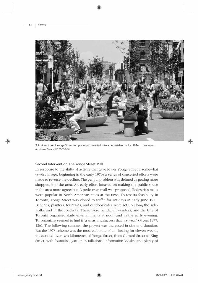
54 history
Second intervention: The yonge Street Mall
In response to the shifts of activity that gave lower Yonge Street a somewhat
tawdry image, beginning in the early 1970s a series of concerted efforts were
made to reverse the decline. The central problem was defined as getting more
shoppers into the area. An early effort focused on making the public space
in the area more agreeable. A pedestrian mall was proposed. Pedestrian malls
were popular in North American cities at the time. To test its feasibility in
Toronto, Yonge Street was closed to traffic for six days in early June 1971.
Benches, planters, fountains, and outdoor cafés were set up along the side-
walks and in the roadway. There were handicraft vendors, and the City of
Toronto organized daily entertainments at noon and in the early evening.
Torontonians seemed to find it “a smashing success that first year” (Myers 1977,
126). The following summer, the project was increased in size and duration.
But the 1973 scheme was the most elaborate of all. Lasting for eleven weeks,
it extended over two kilometres of Yonge Street, from Gerrard Street to King
Street, with fountains, garden installations, information kiosks, and plenty of
2.4 A section of yonge Street temporarily converted into a pedestrian mall, c. 1974. | Courtesy of
Archives of ontario, rG 65-35-2-68.
moore_milroy.indd 54 11/06/2009 11:53:40 AM

55history
street furniture (ibid.; Kilbourn 1984, 22). Figure 2.4 shows the mall in oper-
ation. But the following year, the mall was closed down early, after being
only six weeks in operation. Several reasons were given: the disruption in
traffic was not justifiable, the mall became a gathering place for “degenerates,”
the experiment failed to increase sales for merchants, and there was an in-
crease in nuisance crimes associated with crowd control (Myers 1977, 126-27).
The reasons for closing it down were questioned by a local journalist who
grew up on Yonge Street and who at the time was a newly graduated city
planner. He and several planning school colleagues formed a cooperative that
was hired in 1974 to study the mall. He said they surveyed every single mer-
chant on the street where the pedestrian mall operated and “found that a
majority of the merchants supported the mall. But the big department stores
were against it. They didn’t want people outside listening to speakers and
street musicians. They wanted them inside shopping” (Stein 1996).
Another study of the mall was commissioned by Toronto City Council,
which asked whether the mall should be made permanent. The study recom-
mended that Yonge Street be closed to vehicular circulation from Queen Street
south to Wellington Street and that the sidewalks from Dundas Street to Col-
lege Street be widened. It is interesting to note that, according to this study,
the portion of Yonge most suitable for a full-fledged mall was south of Queen
Street, which suggests that the greatest concentration of activity was in that
area and not near Dundas Street. Pedestrian counts taken in 1969-70 lend
weight to this hypothesis. For example, over the course of the eight-hour day
during which observations were made, the total number of pedestrians at
the Yonge-Queen intersection was about 43,000, while the total number of
pedestrians at Yonge-Dundas was about 30,900, or about 25 percent less. In
addition, although the number of pedestrians at Yonge-Dundas was rela-
tively steady throughout the day, foot traffic at Yonge-Queen more than
doubled in the afternoon, suggesting that this area was a popular destination
for leisure activities in the afternoon and evening. By contrast, the number of
cars passing through the Yonge-Dundas intersection was considerably great-
er (Harrold et al. 1971).
That was not the end of the studies. A subsequent consultants’ report rec-
ommended the opposite, that Yonge Street be kept open in its usual fashion
because “the absence of vehicles and surface transit systems created a some-
what artificial atmosphere – an atmosphere which was sometimes exploited
by hawkers and propagandists” (Globe and Mail 1974).
Ultimately, the pedestrian mall was rejected. It seemed to cause more prob-
lems than it solved. In Kenneth Greenberg’s view, it “amplified the problems
of prostitution, panhandling, and drugs, and created an atmosphere that was
moore_milroy.indd 55 11/06/2009 11:53:40 AM

56 history
perceived to be unpleasant and out of control” (1991, 196). As constructed,
the mall did not address the underlying socioeconomic or investment prob-
lems that, by that time, were clearly manifesting themselves along the street.
Third intervention: The Construction of the eaton Centre
The Yonge and Queen intersection was still the focal point of downtown
shopping in 1963, when the City of Toronto was preparing its self-study
prior to writing its official plan. However, there were early signs that the
clientele of core-area retailers was changing. Their traditional clientele base
had been shoppers from all over the city. Shoppers were now increasingly
downtown workers. The general population was making more and more of
its purchases outside of the core (Toronto 1963, 29). In response, the city
looked to Eaton’s to lead the way in reinforcing the vitality of the downtown
shopping district. The official plan noted that “perhaps the best opportunity
lies in any redevelopment of the extensive T. Eaton Co. Ltd. properties be-
tween Yonge and Bay, north of Queen. As a well-designed project this could
have the great merit of building onto what is already the great downtown
shopping centre” (ibid.).
By the late 1960s, Eaton’s had acquired most of the land that extended from
Yonge Street west to Bay Street and from Queen Street north to Dundas Street.
Its retail operations were still spread throughout a disjointed collection of
buildings that made up the flagship store at Yonge and Queen and the store
at College Street, while manufacturing, catalogue sales, and warehousing were
located in the area south of Dundas Street between Yonge and Bay. It was
time to consolidate. Eaton’s wanted to demolish the whole Queen-Dundas-
Yonge-Bay area and build a new complex that would include office towers,
a new flagship store, and an indoor shopping concourse. Discussions about
a series of plans went on for more than fifteen years. Designs by I.M. Pei were
supplanted by those of E.L. Hankinson; James A. Murray and Victor Gruen;
and Haldenby and Mathers, in conjunction with Skidmore, Owings and Mer-
rill, LLP, respectively (McQueen 1999, 163). By this time it was becoming clear
that redevelopment plans included tearing down the Old City Hall, a classic
late nineteenth-century sandstone building with a clock tower that stood at
Queen and Bay, as well as the Church of the Holy Trinity near Dundas, which
dated from 1847. In addition to the church’s historical and architectural merits,
it had social significance. It was the first Anglican church in Toronto in which
“the working class residents of what was then the outskirts of Toronto could
worship for free” (ibid., 164). In other churches, pews were rented.
Arguments over the sweeping plans to destroy these two landmarks continued
in 1967, when a plan was rejected thanks to the work of an organization
moore_milroy.indd 56 11/06/2009 11:53:40 AM

57history
called Friends of Old City Hall, and in 1972, when another scheme bit the
dust, rejected by Toronto City Council. That scheme was typical for the era:
it called for a fortress-like megastructure that turned its back on the surround-
ing streets. The proposal was a dramatic change from the existing store, which
was known for its elaborate window displays that drew enormous crowds at
Christmas (Toronto 1990a). Under the new scheme, there would be no more
traditional window displays because there would be no windows: “The basic
principle behind the planning of the Centre was that all shoppers, and even
casual pedestrians, would be drawn inside, leaving the city’s streets and
sidewalk-oriented businesses behind” (Dendy 1986, 291).
The plan also called for the demolition of the Church of the Holy Trinity
and the Old City Hall. This sparked another uproar. Torontonians, having
already lost many historic buildings, had become sensitized to their dwindling
built heritage, and the proposal for an Eaton Centre was rejected by Toronto
City Council in 1972. New discussions led Eaton’s to hire the Toronto architect
Eberhard Zeidler to develop a proposal that would better integrate the struc-
ture within the surrounding urban fabric. His design consisted of a huge
galleria, which was modelled loosely on the Galleria Victor Emmanuel in
Milan (which dated from 1867); office towers; and a new nine-storey flagship
store for Eaton’s, which was to be built with its main entrance at Yonge and
Dundas (Toronto 1990a, 24; McQueen 1999). The galleria linked the new
Eaton’s with Simpson’s department store, still at Queen Street. The two de-
partment stores were to be the anchors for smaller shops and restaurants
located on several levels in the galleria. This scheme was thought to be much
better: like Milan’s Galleria, Zeidler’s initial scheme called for a mixture of
uses, including housing, a library, and genuine indoor public space (Dendy
1986, 291). But the developers were not keen on a mixed-use development,
and the concept was dropped. Like earlier plans, Zeidler’s also turned inward
from Yonge Street.2
Construction of the Eaton Centre started in 1973 and took five years to
complete. Once again, access to Yonge Street was made difficult in that area,
just as it had been when the subway was being built (Lemon 1985, 160).
However, although street-level merchants did suffer during the construction
period, the popularity of the Eaton Centre, once completed, brought new life
to a part of the city that had been stagnating, if not declining. When it opened
in 1977, it was an instant success: the number of people entering the mall
averaged 500,000 a week and increased to 750,000 a week during the Christ-
mas season, and Eaton’s total sales increased by 38 percent in the first eight
months of operation (McQueen 1999, 207).3 The number of people entering
the Eaton Centre annually now runs to the tens of millions. Figure 2.5 shows
moore_milroy.indd 57 11/06/2009 11:53:40 AM

58 history
2.5 Toronto eaton Centre interior, looking north, 2008. The photograph shows activity on several levels, the glass arcade effect, and the Canada geese sculptures. | Courtesy of Sherrill rand harrison.
moore_milroy.indd 58 11/06/2009 11:53:40 AM

59history
the Eaton Centre’s interior. According to one commentator, the redevelopment
process gave Torontonians new confidence that city government could have
a positive and formative role in guiding development (Dendy 1986, 293).
Fourth intervention: Downzoning and the 1978 yonge Street
revitalization Project
The Eaton Centre was an anomaly on the Yonge Street Strip: it could com-
mand much higher rents from retailers than other properties, and it attracted
higher-income shoppers. A 1975 plan for the Central Area reduced the floor
space index from 12 to 2 for the east side of the street (Toronto 1975).4 This
is how an economic researcher described that action: “The restrictive planning
policies developed [after the Eaton Centre was underway] assured that the
hugely successful experience could not be repeated on the east side of Yonge
Street as the market would otherwise have encouraged” (Joint Board 1998b,
Exhibit 207A, 17). The siting of the Eaton Centre right at the Yonge Street
sidewalk, and its almost entirely closed facade, brought two-sided retail to a
dead stop along the full length of Yonge Street, from Dundas to Queen.
Amid these circumstances, a consulting firm was hired in 1978 to develop
a strategy to make the street healthy and vibrant (Lyon 1978). It recommended
creating a European-style pedestrian shopping street.5 The long-term vision
for the Central Area included a pedestrianized downtown area (defined by
Yonge, Bay, King, and Queen streets), a ring road system (consisting of Uni-
versity Avenue, College/Carlton streets, Jarvis Street, and Front Street), and
extensive parking facilities at the periphery of the pedestrian precinct. Because
traffic impact studies had not been done to establish the wisdom of making
such dramatic changes, an interim plan proposed widening the sidewalks by
reducing the number of vehicle lanes from four to two to discourage through
traffic. A high-quality pedestrian realm would be created, with appropriate
surface treatments; weather protection in the form of arcades, awnings, and
glass canopies; plantings; seating; outdoor patios for restaurants and cafés;
public toilets at street level; and enhanced entrances to the subway stations
(Greenberg 1991, 196).
The 1978 revitalization proposal was nonetheless rejected. Yonge Street
was not controlled by the city but by the Metropolitan Toronto government,
which designated Yonge Street an important regional traffic artery. It refused
to allow the number of lanes on lower Yonge Street to be reduced, in spite
of the fact that it carried many more people on foot than by car.6 Some at-
tributed this refusal to the fact that the Metropolitan Toronto Council had
more suburban than urban councillors – the former could not grasp the ur-
banity issue that was being presented to them.
moore_milroy.indd 59 11/06/2009 11:53:40 AM

60 history
Derailed but not defeated, the City of Toronto shifted its attention to en-
hancing the streets that intersected with Yonge and over which it had control.
Changes by the city included widening the Gould Street sidewalk on the north
side and installing permanent, canopied vendors’ spaces and several chess
tables and seats. These changes were very successful at the time.
In 1982 another move by city council was to designate the Theatre Block
(bounded by Queen, Yonge, Shuter, and Victoria streets) as a redevelopment
area. The block contains several listed or designated heritage structures, in-
cluding the Elgin and Winter Garden theatres located at 189 Yonge Street, the
concert facilities of Massey Hall at 15 Shuter Street, three historical bank build-
ings (at 173, 197, and 205 Yonge Street), and the former Heintzman building
at 193 Yonge Street.7 Between two of the banks was the Colonial Tavern,
which was listed by the Toronto Historical Board solely to protect the facades
of the banks it abutted. This is not to say that the Colonial Tavern had not had
its own moments of significance. Members of Jazz Watch and the Jazz Action
Society came to council to attest that “international musicians such as Duke
Ellington, Count Basie, Oscar Peterson, Miles Davis, Dizzy Gillespie, Sarah
Vaughan, and Buck Clayton found Toronto and the Colonial one of their fa-
vourite places to perform” (Joint Board 1998b, Exhibit 96). However, the
Colonial Tavern had fallen on hard times and, by then, belonged to the city.
A revitalization concept for part of the block began to take shape when the
provincial and federal governments announced they would contribute to
restoring the Elgin and Winter Garden theatres, which were then owned by
the province’s Ministry of Citizenship and Culture and the Ontario Heritage
Foundation. The councillor who headed the task force on the Theatre Block
likened the initiative to “a cross between a miniature Lincoln Centre and Times
Square, if all its theatres were to be cleaned up” (cited in Godfrey 1983). The
idea was to demolish the Colonial Tavern, which was dilapidated, and create
a landscaped passage between the two rather beautiful old banks from Yonge
through to Victoria Street. The Colonial Tavern’s golden age of jazz would be
recalled through the design of the passage and by naming it “Jazz Place.”
Meanwhile, the Pantages Theatre on Victoria Street was undergoing chan-
ges. The theatre has a fascinating history. With 3,373 seats, it was the largest
and most elegant Canadian theatre that served both vaudeville and motion
picture audiences (Mirvish Productions; for a different, colourful account, see
Drabinsky 1995, chap. 14). It was designed by Thomas Lamb, built in 1920
by the Canadian motion picture distributor Nathan L. Nathanson, owned by
Pericles Alexander Pantages until he was jailed in 1929, sold to RKO Pictures,
which became Famous Players, and renamed the Imperial in 1930. The theatre
was later divided into a six-plex cinema in 1973; half of it was seized by
moore_milroy.indd 60 11/06/2009 11:53:40 AM

61history
Cineplex Odeon in 1986 through an administrative oversight by Famous Play-
ers. It was soon transferred to Garth Drabinsky’s Livent, rebuilt for live theatre
again under the name the Pantages, and reopened in 1989, only to be lost in
bankruptcy proceedings to SFX/Clear Channel Entertainment. The theatre,
having been renamed the Canon Theatre in 2001 in recognition of financial
support from Canon Canada, is currently managed and programmed by Mir-
vish Productions. It is oddly configured in that it has a fancy, if small, entrance
on Yonge Street, while the bulk of the building is on Victoria Street, where
the box office is located.
The Elgin and Winter Garden theatres were built together as a unit in 1913.
Like the Pantages, they were designed by Thomas Lamb and have spotty
histories. The Winter Garden, fitted out like a botanical fantasy, was closed
in 1928, while the Elgin continued as a movie theatre. The Ontario Heritage
Foundation bought both buildings in 1981, renovated them at a cost of $30
million, and reopened them – the Elgin in 1985 and the Winter Garden in
1989 – as live performance theatres (see also Ontario Heritage Foundation).
The city was thus moving along with initiatives when it could see an open-
ing. But private investment in the street’s properties was not forthcoming,
which meant public investments had modest effect. Within a couple of years,
the city was gripped in a serious economic recession, as were other levels of
government and the private sector. This would all but halt investments for
about five years.
Fifth intervention: Cityplan ’91 and the retailing Problem
The fifth intervention played out in 1994. Eaton’s threatened to challenge the
city’s newly created official plan at the Ontario Municipal Board because, in
the company’s view, the plan did not adequately champion retailing in the
core. The negotiations between the city and the company that ensued were
directly connected to plans for redeveloping the Yonge-Dundas area, which
is the subject of this book, so discussion of this intervention is postponed
until the next chapter.
In concluding this look at the evolution of lower Yonge Street, it is obvious
that its character, including the location and nature of shopping and entertain-
ment over the stretch between King and College/Carlton streets, has been
anything but constant. For a period in the first half of the twentieth century,
portions of the street served as the city’s shopping district of choice, but this
changed after the Second World War. Major public-sector interventions have
had mixed effects. To successfully change the pattern of use on Yonge Street
is undoubtedly complicated. The city has been careful over the decades not
to leap too quickly.
moore_milroy.indd 61 11/06/2009 11:53:40 AM

62 history
Before investigating the most recent proposals and actions, which are dis-
cussed in the next chapter, we turn our attention to the history of the Yonge-
Dundas intersection. In arguments about fixing the area, the intersection was
referred to as the “Main and Main” of the city and also as its heart (Joint Board
1998k, 3).
Yonge and Dundas
Although Yonge Street as a whole is clearly of great importance to Toronto,
the idea that Yonge-Dundas has traditionally been a major urban hub is er-
roneous. Dundas has been relatively insignificant as an east-west axis. In the
nineteenth century there was a Dundas Street that began far to the west of the
city centre at what is now the intersection of Ossington Avenue and Queen
Street. It meandered westward toward the town of Dundas, near the city of
Hamilton (Careless 1984, 25; Armstrong 1988, 44), just as Kingston Road in the
eastern suburbs led to the city of Kingston. The current incarnation of Dundas
Street is the result of a civic improvement project of the early part of the twen-
tieth century, the goal of which was to create a new east-west traffic link to
improve the efficiency of the city’s circulation networks (Careless 1984, 193).
Starting in 1916, a series of east-west streets that ran a suitable distance north
of Queen were joined together and renamed Dundas Street (Filey 1986).8 The
new crosstown route linked the west end road known originally as Dundas
with neighbourhoods to the east, beyond the Don Valley.9 This improvised
street wanders across Toronto’s orthogonal grid with a great many jogs and
several unusual intersections.
At what is now Yonge and Dundas, creating the intersection involved forcing
Wilton Street (on the east of Yonge) and Agnes Street (on the west of Yonge)
to meet. At Yonge Street, these two streets were out of alignment by about
seventy metres. Figure 2.6 shows the proposed route of the alignment. Sev-
eral properties on Yonge Street and Victoria Street (to the east) had to be
demolished so that the continuation of Dundas was straight enough to support
a streetcar line.10 This left a parcel of land that was called Old Wilton Square
and later renamed Dundas Square (Joint Board 1998b, Exhibit 162, 7).
Throughout the nineteenth century, the streets around Dundas and Yonge
were local in nature and largely residential in use. The housing was built and
poorly serviced, and it was overcrowded. To the west of what is now Yonge
and Dundas was one of Toronto’s lowest-income neighbourhoods, a settle-
ment area for successive waves of impoverished immigrants – Irish, eastern
Europeans, Italians, and Chinese (Careless 1984, 157; Kluckner 1988, 135-42).
The streets also housed Eaton’s back offices, which supported the company’s
sprawling store to the south and its national retail activities. The company’s
moore_milroy.indd 62 11/06/2009 11:53:40 AM

63history
central mail-order warehouse was located there, as was a multistorey manu-
facturing complex in which much of the clothing Eaton’s distributed to its
stores across Canada was made (Dendy 1986, 291; Lemon 1985, 39). Residents
of the area provided cheap labour for these clothing manufacturers: “Sharing
the blocks with the little houses and shops were factories of every size and
description ... there was scarcely a block that did not have some sort of tailor-
ing enterprise, ranging from well-organized factories in lofts to the meanest,
most pitiful sweatshops in grubby lean-tos in the back alleyways” (Kluckner
1988, 135).
The 1934 Bruce Report on housing conditions in Toronto showed that
dwellings with below-standard amenities began to be concentrated west of
2.6 Plan to connect Dundas Street West and east. | Daily Star 1921.
moore_milroy.indd 63 11/06/2009 11:53:40 AM

64 history
Yonge, from about Dundas to near College, and increased in density as one
moved farther west to Spadina and Bathurst (Toronto 1934, 16-17).
Still on the west side of Yonge, the city’s poorhouse (known as the House
of Industry) occupied almost an entire block on Elm Street, just a stone’s throw
from the Dundas Square site. Slightly west of that, on Centre Avenue, was the
city’s equivalent of a red-light district (Kluckner 1988, 135). Consequently, in
the Toronto of old, steeped as it was in Victorian notions of morality, this area
was often perceived as being marked by immorality and crime.
The character of the land use was no more polished on the east side of
Yonge than on the west. There was likewise a mix of residential, commercial,
and retail property or land, but there was only one major industrial use –
brewing. According to an environmental assessment of the area prepared for
the city by consultants, “the only industrial development in the area was the
O’Keefe Brewing Co. Ltd. which was located on the east and west side of
Victoria Street, between Gould Street and Dundas Street East. The O’Keefe
Brewing Co. Ltd. discontinued operations at the site in the mid-1960s. The
buildings were vacated and remained unused until demolition. The property
was subsequently purchased by Ryerson Polytechnical Institute” (Joint Board
1998b, Exhibit 162, 6). Just to the northeast of the brewery was St. James
Square, one of Toronto’s few planned open spaces (Dendy 1993, 150). It was
surrounded by three elegant buildings that housed the Normal School, the
Model School, and the Department of Education. These buildings later became
the home of what is now Ryerson University. When Ryerson was founded on
the site in 1949, it was sitting in the midst of what Ron Stagg (1998) has de-
scribed as “one of the less desirable areas of Toronto.”
From 1899 the Society for Working Boys operated a home for disadvantaged
youth on Gould Street, a block north of Dundas. In 1958 that building became
the Ryerson Student Union building. Just a couple of blocks away, on the east
side of Yonge between Gould and Gerrard (at no. 381), was the Yonge Street
Mission. It has continuously operated at that location since 1904, serving vari-
ous publics, most recently youth. It was named Evergreen in 1979 (Mathers
and Mohamed 2004, 1-2).
The uses that have occupied the four corners of Yonge and Dundas over
the years have not convinced us that the area has been the heart of the city,
the main and main. The city’s 1959 interim plan predicted that the area would
consist of higher-density housing, with local shopping along Yonge Street
north of Dundas (Toronto 1959). In the 1960s the City of Toronto (Toronto
1963, 40) noted that, aside from limited warehousing and manufacturing uses,
and some wholesale or retail activity along Victoria Street, the area was pri-
marily residential. The city’s own interpretation of the area on the east side
moore_milroy.indd 64 11/06/2009 11:53:40 AM

65history
of Yonge at Dundas was as follows: “In all, this part of downtown is occupied
by a number of distinct elements and several very mixed pockets. It is not a
cohesive unit, but rather a backwater between more important, recognizable
areas ... The area has no special advantage for office or retail business which
would change its character” (ibid., 40-41).
A few years later, in 1971, the director of the City of Toronto Planning
Board, on the subject of Dundas’ role as an east-west axis, said that “any
concept of Dundas Street as a cross-City connector seems questionable” (To-
ronto 1971, 2).
Although Dundas Street does have a role as a local shopping street in certain
sections (e.g., in Kensington Market, west of Spadina), for the most part it is
not distinctive. In fact, to the east of the Don Valley, Dundas is primarily a
residential street. Clearly, Dundas, unlike Queen to the south or Bloor to the
north, never did develop as an important east-west axis of any sort.
Taking the background of Yonge and Dundas into account, it is odd that
this intersection should be described as the “main and main” of Toronto. If it
is the heart, it has come by this distinction because of the Eaton Centre en-
trance, not because the intersection was especially distinctive otherwise. As
we will see, that distinctive entrance was removed in the course of redevelop-
ment because it was a magnet for people who liked to hang around, to
proselytize, and to ply the informal economy.
Conclusion
The Yonge-Dundas area has been constantly busy over the years with retail
or commercial and residential uses, as well as brewing, warehousing, and
garment manufacturing. Whatever stylishness one could attribute to the area
tended to be found closer to Queen than to Dundas. More raunchy activities
had asserted their presence on Yonge north of Shuter and mainly north of
Dundas by around the early 1970s.
The claim made by proponents of this project that Yonge-Dundas was once
the flourishing and vibrant heart of the downtown is not corroborated by
historical evidence. Nor is there substance to the claim that it was a fashion-
able part of the city that had fallen on hard times. In 1963 the City of To-
ronto described Yonge-Dundas as the “backwater between more important,
recognizable areas.” It has been given a nostalgic past that is more correctly
attributed to other nodes on Yonge.
These facts did not stop the fall-and-redemption and rotting heart imagery
from being used with considerable effect in efforts to generate support for
redevelopment plans. The use of this type of blatant imagery is common in
the business of selling cities and development. It is unlikely to work on its
moore_milroy.indd 65 11/06/2009 11:53:41 AM

66 history
own, but as part of building up meaning through images, and as a form of
rhetoric used in the course of trying to persuade, it is often part of a purpose-
ful strategy for gaining attention. Indeed, speakers often use metaphors
without being aware of doing so or of how inaccurate the imagery is, which
is probably the case here.
On the one hand, we have no choice but to use metaphors. On the other,
we should not be taken in by our own metaphors. Use of metaphor is built
deep into Western ways of thinking, speaking, and writing. Consequently, we
should be urged to ask in any given instance, what metaphor is at work? It
should be opened up to critical analysis.
If the use of imagery in urban redevelopment is common, why do we need
yet another story to illustrate it? The answer is because we still have not in-
corporated imagery and its effects into a theory of how planning works.
Imagery is still treated as if it were an aberration rather than part of how
planning functions. Certainly, metaphors should not stand unquestioned as
the basis for a redevelopment project.11 This is a central message of this book.
This chapter has also illustrated how the core of the city altered, over a
century or so, in concert with changes occurring to its surrounding urban
region. What was left was a small space that no longer provided the essential
goods and services of daily life to the growing population on its ever expanding
periphery.
moore_milroy.indd 66 11/06/2009 11:53:41 AM