there’s no difference between grid and ground · there’s no difference nysapls 2011 conference...
TRANSCRIPT
1
There’s No Difference There’s No Difference
NYSAPLS 2011 Conference
January 19, 2011
Between Grid and Ground Between Grid and Ground
Joseph V.R. Paiva, PhD, PS, PEJoseph V.R. Paiva, PhD, PS, PE
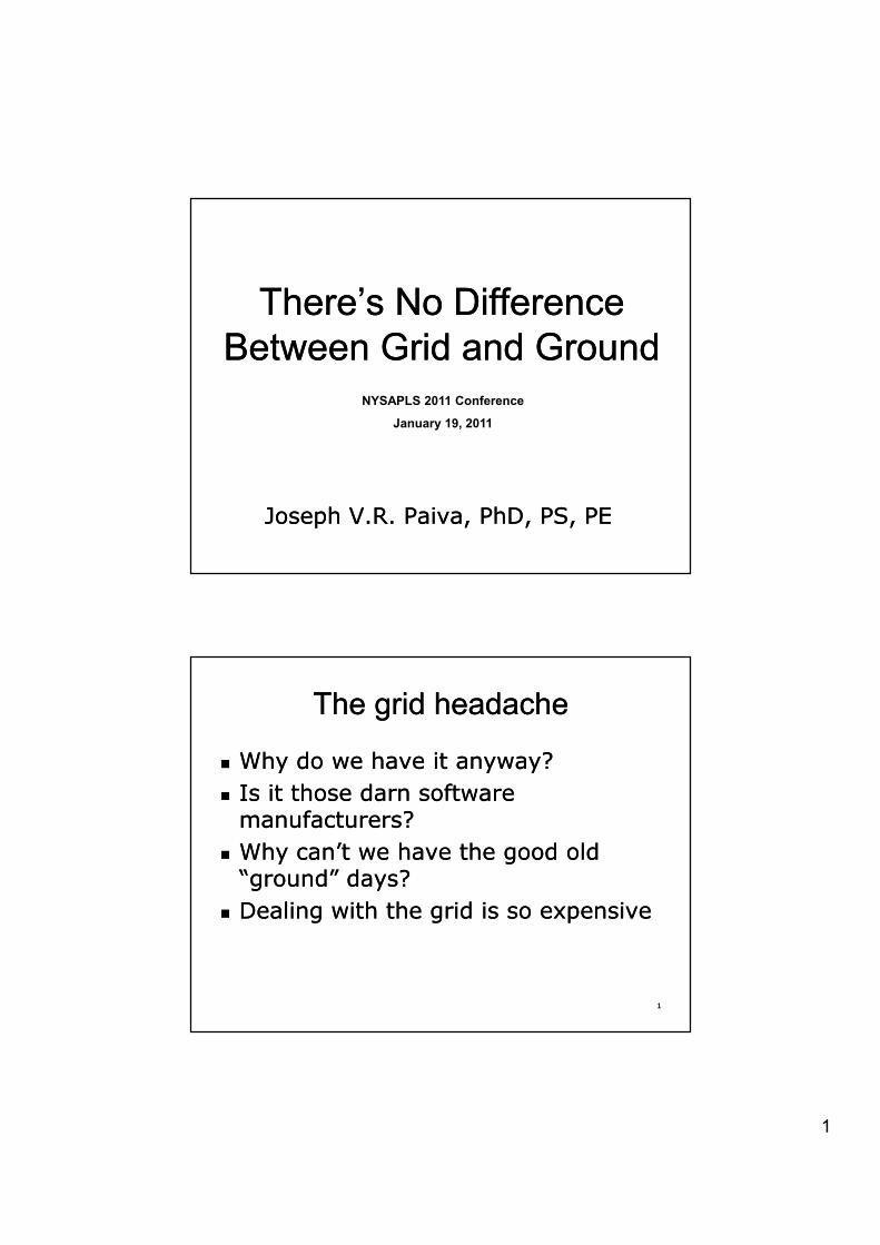
The grid headacheThe grid headache
�� Why do we have it anyway?Why do we have it anyway?�� Is it those darn software Is it those darn software
manufacturers?manufacturers?�� Why can’t we have the good old Why can’t we have the good old
“ground” days“ground” days??Dealing with the grid is so expensiveDealing with the grid is so expensive
11
�� Dealing with the grid is so expensiveDealing with the grid is so expensive
2
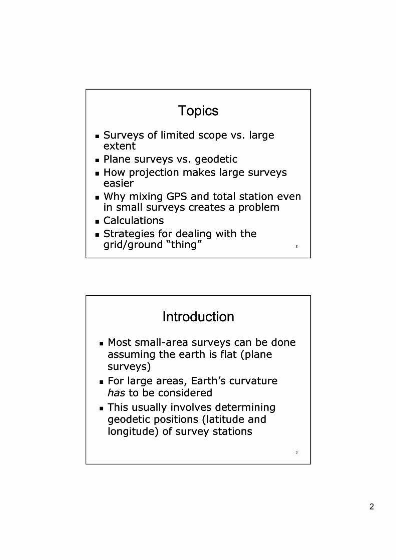
TopicsTopics
�� Surveys of limited scope vs. large Surveys of limited scope vs. large extentextentextentextent
�� Plane surveys vs. geodeticPlane surveys vs. geodetic�� How projection makes large surveys How projection makes large surveys
easiereasier�� Why mixing GPS and total station even Why mixing GPS and total station even
22
ggin small surveys creates a problemin small surveys creates a problem
�� CalculationsCalculations�� Strategies for dealing with the Strategies for dealing with the
grid/ground grid/ground “thing”“thing”
IntroductionIntroduction
�� Most smallMost small--area surveys can be done area surveys can be done i th th i fl t ( l i th th i fl t ( l assuming the earth is flat (plane assuming the earth is flat (plane
surveys)surveys)�� For large areas, Earth’s curvature For large areas, Earth’s curvature
hashas to be consideredto be considered�� This usually involves determining This usually involves determining
33
�� This usually involves determining This usually involves determining geodetic positions (latitude and geodetic positions (latitude and longitude) of survey stationslongitude) of survey stations

3
State Plane Coordinate SystemState Plane Coordinate System
�� SPCS was designed in the early SPCS was designed in the early 1930 b th (th ) C t d 1930 b th (th ) C t d 1930s by the (then) Coast and 1930s by the (then) Coast and Geodetic survey to solve the problem Geodetic survey to solve the problem of surveys of large extents for the of surveys of large extents for the “local” surveyor“local” surveyor
�� In addition to allowing plane survey In addition to allowing plane survey
44
In addition to allowing plane survey In addition to allowing plane survey concepts to be used, it delivers concepts to be used, it delivers several additional benefitsseveral additional benefits
SPCS benefitsSPCS benefits
�� Simplifies calculations for surveys Simplifies calculations for surveys over large distancesover large distancesover large distancesover large distances
�� Provides common datum of reference Provides common datum of reference for all surveys (if tied in)for all surveys (if tied in)
�� Well suited for engineering projects Well suited for engineering projects of large extent, i.e. highways, but of large extent, i.e. highways, but l h t t l l l h t t l l
55
also photogrammetry, large scale also photogrammetry, large scale cadastral surveys, etc.cadastral surveys, etc.
4
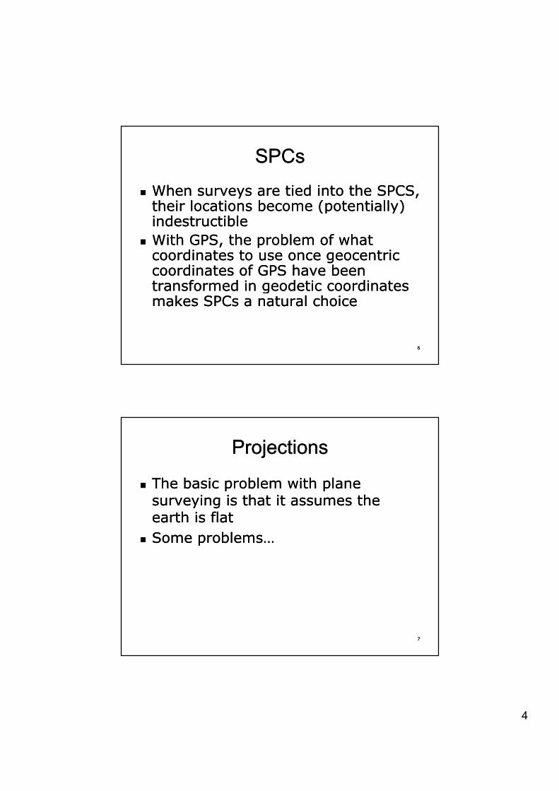
SPCsSPCs
�� When surveys are tied into the SPCS, When surveys are tied into the SPCS, their locations become (potentially) their locations become (potentially) their locations become (potentially) their locations become (potentially) indestructibleindestructible
�� With GPS, the problem of what With GPS, the problem of what coordinates to use once geocentric coordinates to use once geocentric coordinates of GPS have been coordinates of GPS have been transformed in geodetic coordinates transformed in geodetic coordinates
66
transformed in geodetic coordinates transformed in geodetic coordinates makes SPCs a natural choicemakes SPCs a natural choice
ProjectionsProjections
�� The basic problem with plane The basic problem with plane i i th t it th i i th t it th surveying is that it assumes the surveying is that it assumes the
earth is flatearth is flat�� Some problems…Some problems…
77
5
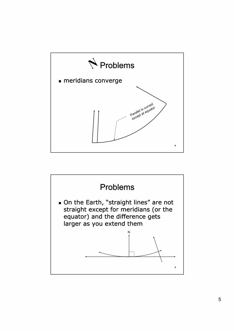
ProblemsProblems
�� meridians convergemeridians converge
88
ProblemsProblems
�� On the Earth, “straight lines” are not On the Earth, “straight lines” are not t i ht t f idi ( th t i ht t f idi ( th straight except for meridians (or the straight except for meridians (or the
equator) and the difference gets equator) and the difference gets larger as you extend themlarger as you extend them
N
99
6
ProblemsProblems
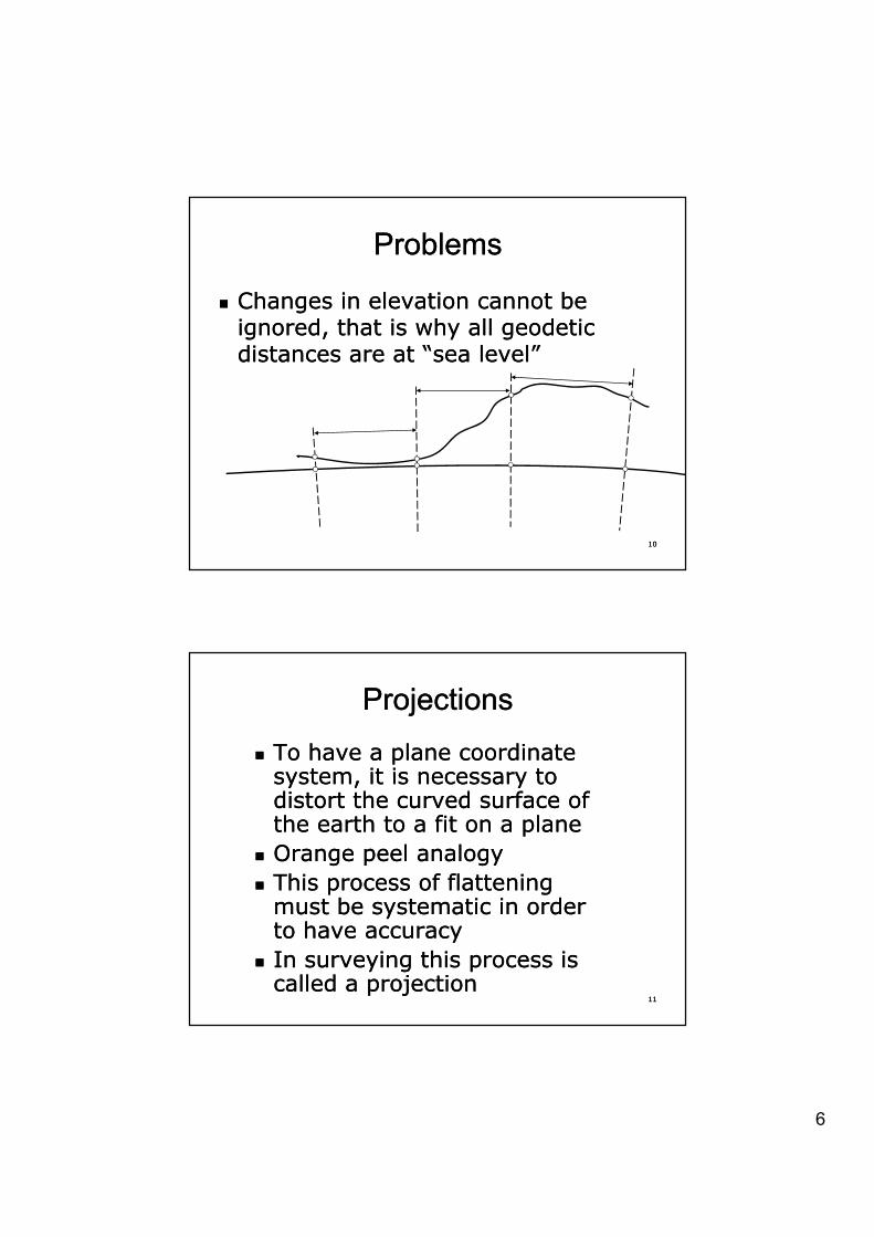
�� Changes in elevation cannot be Changes in elevation cannot be i d th t i h ll d ti i d th t i h ll d ti ignored, that is why all geodetic ignored, that is why all geodetic distances are at “sea level”distances are at “sea level”
1010
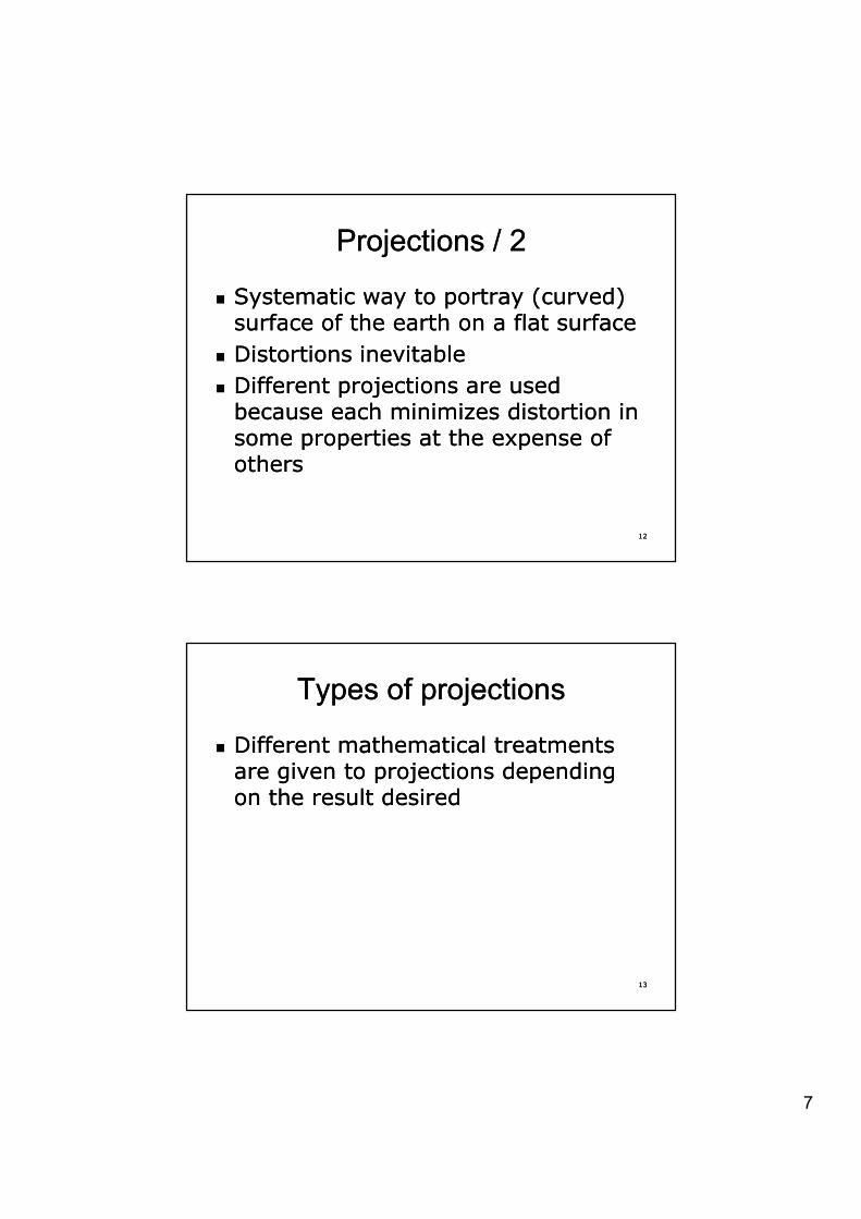
ProjectionsProjections�� To have a plane coordinate To have a plane coordinate
system it is necessary to system it is necessary to system, it is necessary to system, it is necessary to distort the curved surface of distort the curved surface of the earth to a fit on a planethe earth to a fit on a plane
�� Orange peel analogyOrange peel analogy�� This process of flattening This process of flattening
t b t ti i d t b t ti i d
1111
must be systematic in order must be systematic in order to have accuracyto have accuracy
�� In surveying this process is In surveying this process is called a projectioncalled a projection
7
Projections / 2Projections / 2
�� Systematic way to portray (curved) Systematic way to portray (curved) f f th th fl t ff f th th fl t fsurface of the earth on a flat surfacesurface of the earth on a flat surface
�� Distortions inevitableDistortions inevitable�� Different projections are used Different projections are used
because each minimizes distortion in because each minimizes distortion in some properties at the expense of some properties at the expense of
1212
some properties at the expense of some properties at the expense of othersothers
Types of projectionsTypes of projections
�� Different mathematical treatments Different mathematical treatments i t j ti d di i t j ti d di are given to projections depending are given to projections depending
on the result desiredon the result desired
1313
8
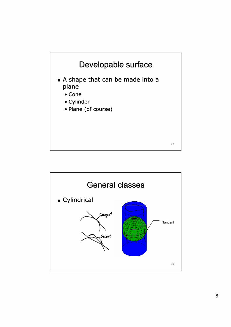
Developable surfaceDevelopable surface
�� A shape that can be made into a A shape that can be made into a llplaneplane
•• Cone Cone •• CylinderCylinder•• Plane (of course)Plane (of course)
1414
General classesGeneral classes
�� CylindricalCylindrical
Tangent
1515
9
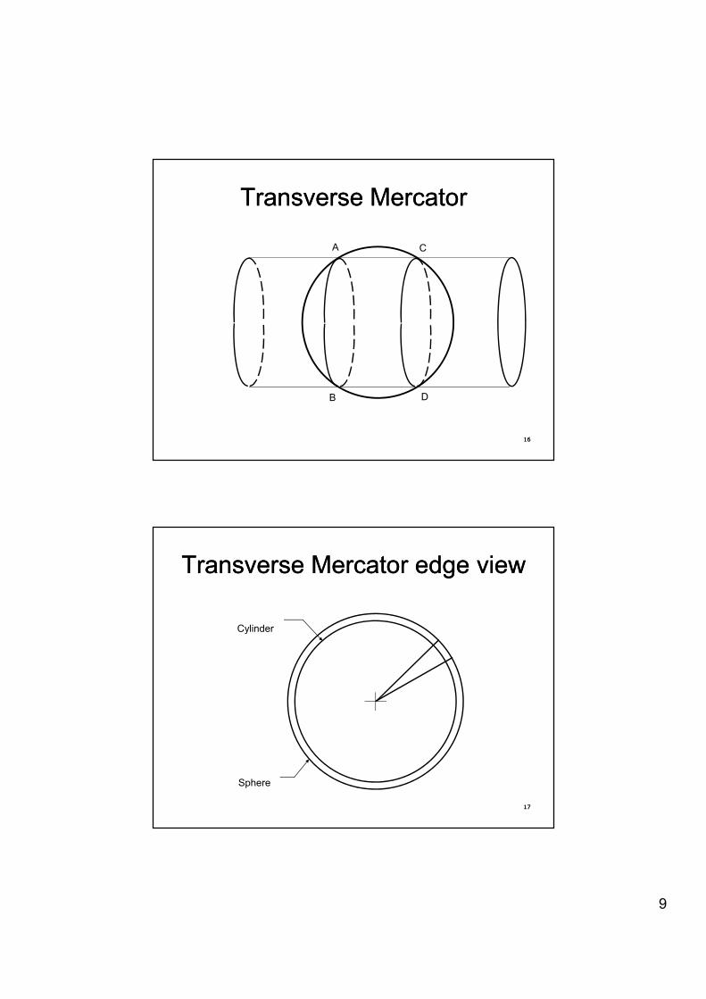
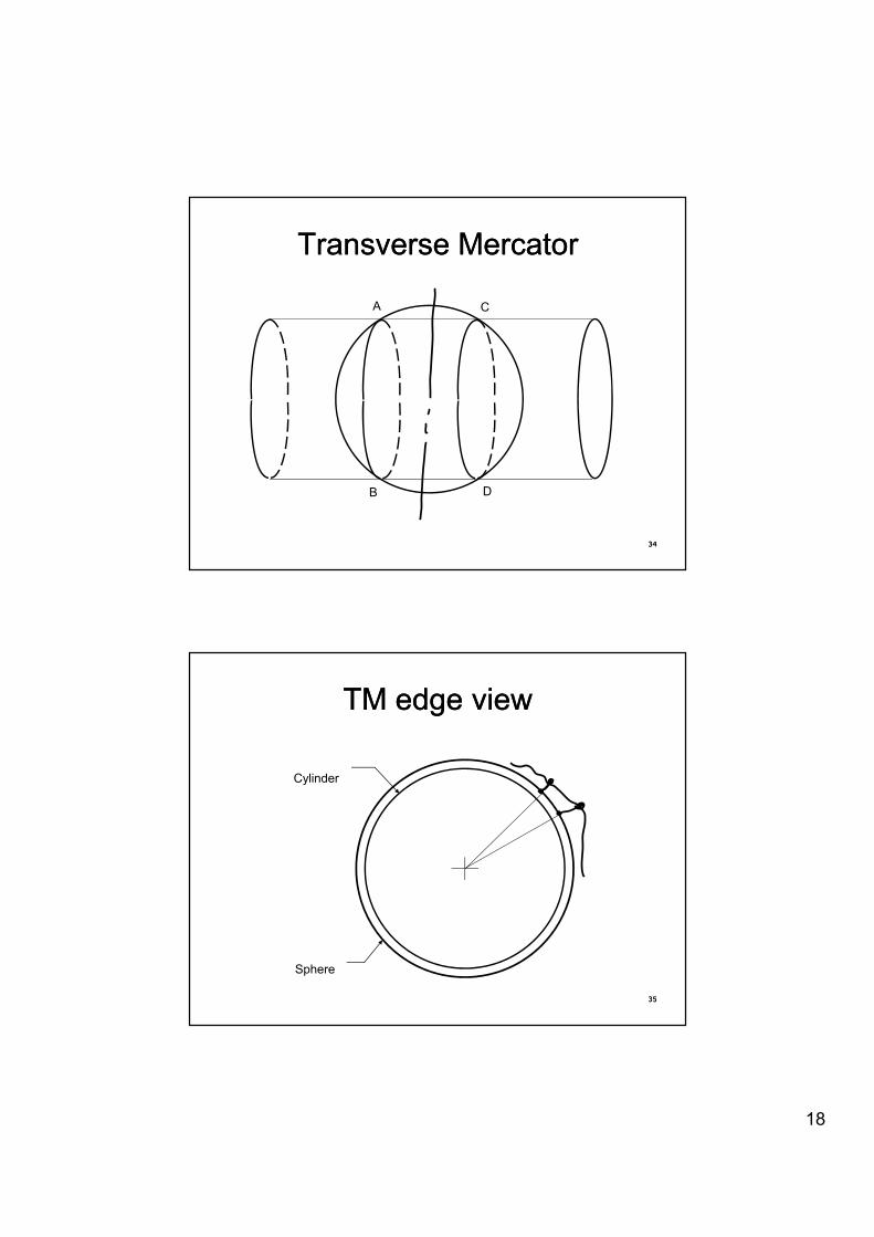
Transverse MercatorTransverse Mercator
A C
1616
B D
Transverse Mercator Transverse Mercator edge viewedge view
CylinderCylinder
1717
Sphere
10
General classesGeneral classes
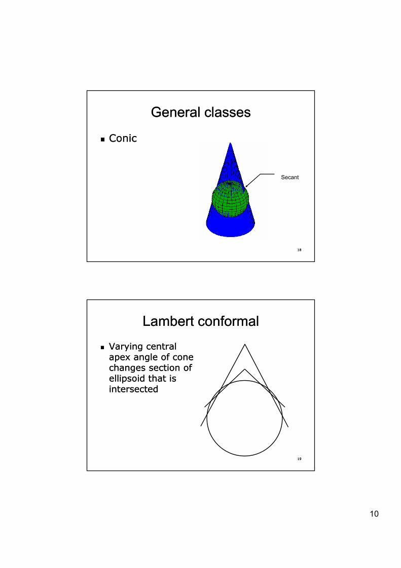
�� ConicConic
Secant
1818
Lambert conformalLambert conformal
�� Varying central Varying central apex angle of cone apex angle of cone apex angle of cone apex angle of cone changes section of changes section of ellipsoid that is ellipsoid that is intersectedintersected
1919
11
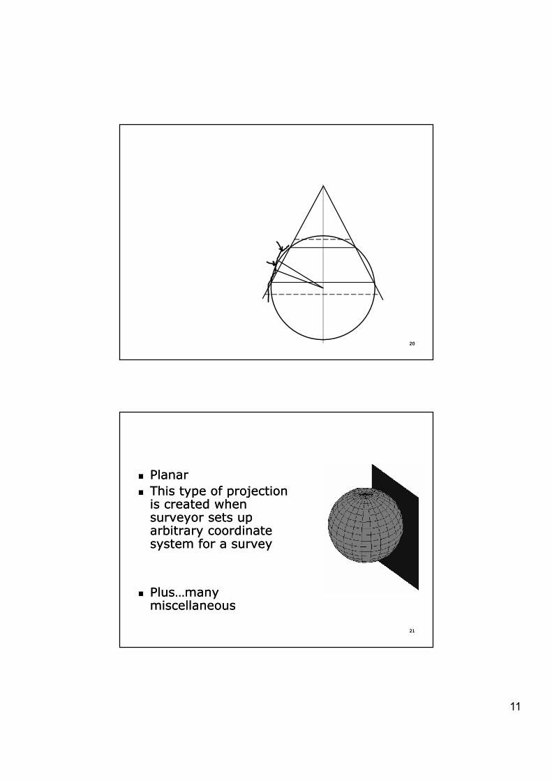
2020
�� PlanarPlanarThis type of projection This type of projection �� This type of projection This type of projection is created when is created when surveyor sets up surveyor sets up arbitrary coordinate arbitrary coordinate system for a surveysystem for a survey
2121
�� Plus…many Plus…many miscellaneousmiscellaneous
12
Next stepNext step
�� Once developable surface Once developable surface parameters are picked plane is parameters are picked plane is parameters are picked, plane is parameters are picked, plane is createdcreated
�� Because a developable surface is Because a developable surface is used, while there are distortions in used, while there are distortions in converting coordinates on the earth converting coordinates on the earth to the developable surface there is to the developable surface there is
2222
to the developable surface, there is to the developable surface, there is no further distortion of shape or size no further distortion of shape or size when it is unrolled or “developed”when it is unrolled or “developed”
Most common surfaces in SPCSMost common surfaces in SPCS
�� Lambert conformal (conic)Lambert conformal (conic)�� Transverse Mercator (cylinder)Transverse Mercator (cylinder)�� Also…skewed (or oblique) Also…skewed (or oblique) Mercator Mercator
where axis of cylinder is not eastwhere axis of cylinder is not east--westwest
2323
13
State Plane Coordinate State Plane Coordinate Systems (83)Systems (83)
�� System for specifying System for specifying d ti t ti i l d ti t ti i l geodetic stations using plane geodetic stations using plane
rectangular coordinatesrectangular coordinates�� Over 120 zones for U.S.Over 120 zones for U.S.�� Long Long NN--SS states use states use
Transverse MercatorTransverse Mercator
2424
Transverse MercatorTransverse Mercator�� Long Long EE--WW states use Lambertstates use Lambert�� If square, use eitherIf square, use either
SPCS (83)SPCS (83)
�� Alaska, Florida and New York use Alaska, Florida and New York use b th t f j tib th t f j tiboth types of projectionsboth types of projections
�� In addition Alaska has an oblique In addition Alaska has an oblique projection for the southeastern part projection for the southeastern part of the stateof the state
2525
14
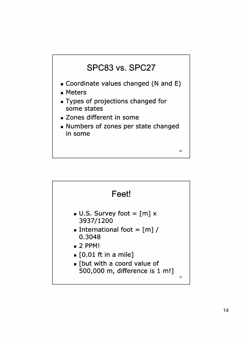
SPC83 vs. SPC27SPC83 vs. SPC27
�� Coordinate values changed (N and E)Coordinate values changed (N and E)�� MetersMeters�� Types of projections changed for Types of projections changed for
some statessome states�� Zones different in someZones different in some
b f h db f h d
2626
�� Numbers of zones per state changed Numbers of zones per state changed in somein some
Feet!Feet!
�� U.S. Survey foot = [m] x U.S. Survey foot = [m] x U.S. Survey foot [m] x U.S. Survey foot [m] x 3937/12003937/1200
�� International foot = [m] / International foot = [m] / 0.30480.3048
�� 2 PPM2 PPM!!
2727
�� [0.01 ft in a mile][0.01 ft in a mile]�� [but with a [but with a coordcoord value of value of
500,000 m, difference is 1 500,000 m, difference is 1 m!]m!]
15
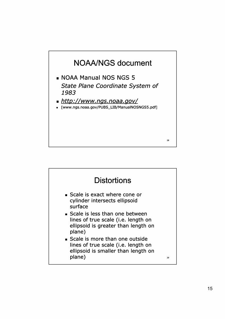
NOAA/NGS documentNOAA/NGS document
�� NOAA Manual NOS NGS 5NOAA Manual NOS NGS 5State Plane Coordinate System of State Plane Coordinate System of 19831983
�� http://www.ngs.noaa.gov/http://www.ngs.noaa.gov/�� [www.ngs.noaa.gov/PUBS_LIB/ManualNOSNGS5.pdf][www.ngs.noaa.gov/PUBS_LIB/ManualNOSNGS5.pdf]
2828
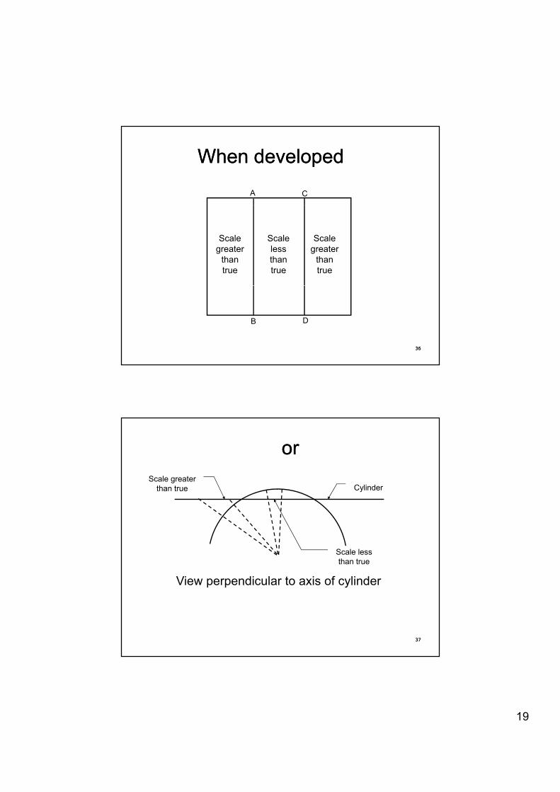
DistortionsDistortions
�� Scale is exact where cone or Scale is exact where cone or cylinder intersects ellipsoid cylinder intersects ellipsoid cylinder intersects ellipsoid cylinder intersects ellipsoid surfacesurface
�� Scale is less than one between Scale is less than one between lines of true scale (i.e. length on lines of true scale (i.e. length on ellipsoid is greater than length on ellipsoid is greater than length on plane)plane)
2929
plane)plane)�� Scale is more than one outside Scale is more than one outside
lines of true scale (i.e. length on lines of true scale (i.e. length on ellipsoid is smaller than length on ellipsoid is smaller than length on plane)plane)
16
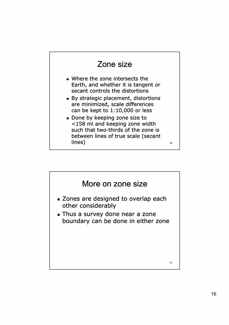
Zone sizeZone size
�� Where the zone intersects the Where the zone intersects the Earth and whether it is tangent or Earth and whether it is tangent or Earth, and whether it is tangent or Earth, and whether it is tangent or secant controls the distortionssecant controls the distortions
�� By strategic placement, distortions By strategic placement, distortions are minimized, scale differences are minimized, scale differences can be kept to 1:10,000 or lesscan be kept to 1:10,000 or lessDone by keeping zone size to Done by keeping zone size to
3030
�� Done by keeping zone size to Done by keeping zone size to <158 mi and keeping zone width <158 mi and keeping zone width such that twosuch that two--thirds of the zone is thirds of the zone is between lines of true scale (secant between lines of true scale (secant lines)lines)
More on zone sizeMore on zone size
�� Zones are designed to overlap each Zones are designed to overlap each th id blth id blother considerablyother considerably
�� Thus a survey done near a zone Thus a survey done near a zone boundary can be done in either zoneboundary can be done in either zone
3131
17
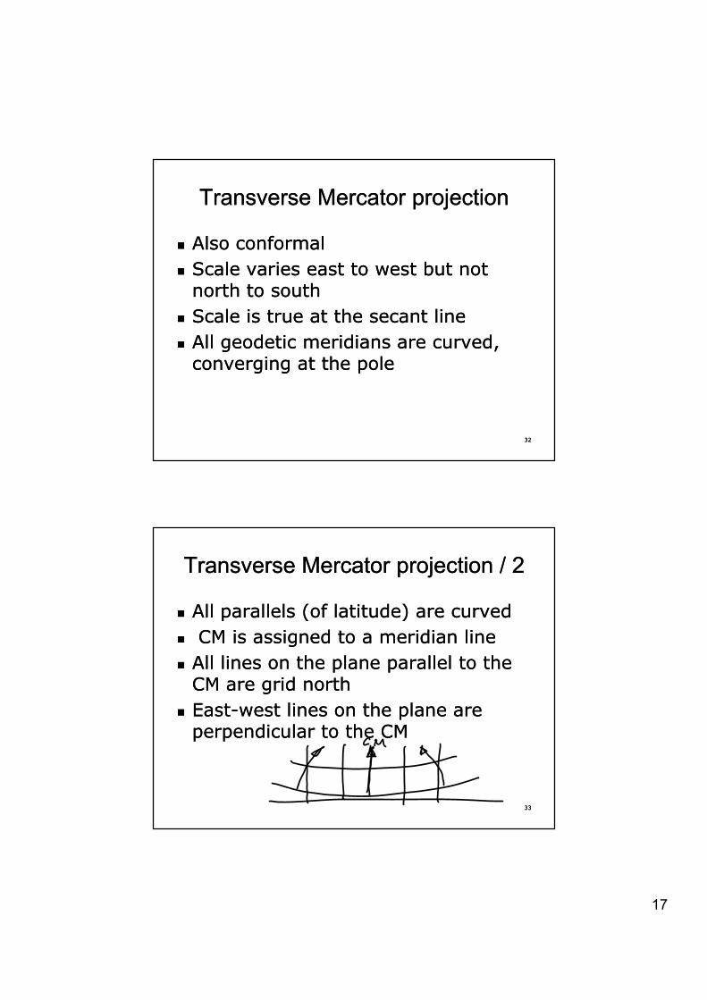
Transverse Mercator projectionTransverse Mercator projection
�� Also conformalAlso conformal�� Scale varies east to west but not Scale varies east to west but not
north to southnorth to south�� Scale is true at the secant lineScale is true at the secant line�� All geodetic meridians are curved, All geodetic meridians are curved,
converging at the poleconverging at the pole
3232
converging at the poleconverging at the pole
Transverse Mercator projection / 2Transverse Mercator projection / 2
�� All parallels (of latitude) are curvedAll parallels (of latitude) are curved�� CM is assigned to a meridian lineCM is assigned to a meridian line�� All lines on the plane parallel to the All lines on the plane parallel to the
CM are grid northCM are grid north�� EastEast--west lines on the plane are west lines on the plane are
perpendicular to the CMperpendicular to the CM
3333
perpendicular to the CMperpendicular to the CM
18
Transverse MercatorTransverse Mercator
A C
3434
B D
TM edge viewTM edge view
CylinderCylinder
3535
Sphere
19
When developed When developed
A C
Scale greater
than true
Scale greater
than true
Scale less than true
3636
B D
or or
CylinderScale greater
than true
Vi di l t i f li d
Scale less than true
3737
View perpendicular to axis of cylinder
20
Mapping angleMapping angle
�� Also called grid declination or Also called grid declination or i tii tivariationvariation
�� Greek letter Greek letter -- JJ [gamma][gamma]
3838
Grid overlaid on developed Grid overlaid on developed surfacesurface
CM (C t l M idi )CM (Central Meridian)E0
3939
21
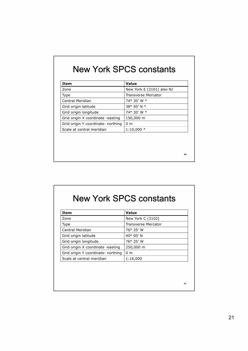
New York SPCS constantsNew York SPCS constantsItem ValueZone New York E (3101) also NJ( )Type Transverse MercatorCentral Meridian 74° 30’ W *Grid origin latitude 38° 50’ N *Grid origin longitude 74° 30’ W *Grid origin X coordinate -easting 150,000 mGrid origin Y coordinate- northing 0 mScale at central meridian 1:10,000 *
4040
New York SPCS constantsNew York SPCS constantsItem ValueZone New York C (3102)( )Type Transverse MercatorCentral Meridian 76° 35’ W Grid origin latitude 40° 00’ N Grid origin longitude 76° 35’ W Grid origin X coordinate -easting 250,000 mGrid origin Y coordinate- northing 0 mScale at central meridian 1:16,000
4141

22
New York SPCS constantsNew York SPCS constantsItem ValueZone New York W (3103)( )Type Transverse MercatorCentral Meridian 78° 35’ W Grid origin latitude 40° 00’ N Grid origin longitude 78° 35’ W Grid origin X coordinate -easting 350,000 mGrid origin Y coordinate- northing 0 mScale at central meridian 1:16,000
4242
New York SPCS constantsNew York SPCS constantsItem ValueZone Lambert (3104)( )Type Lambert ConformalCentral Meridian 74° 00’ W Standard parallel N 41° 02’ N Standard parallel S 40° 40’ W Grid origin latitude 40° 10’N *Grid origin longitude 74° 00’WGrid origin X coordinate -easting 300,000 mGrid origin Y coordinate- northing 0 mScale at central meridian 1:16,000
4343

23
From Appendix CFrom Appendix C
4444
Calculation of ECalculation of EPP’’Distance from Central Meridian
N
E0
EP’
CM
4545
E
P
EP
24
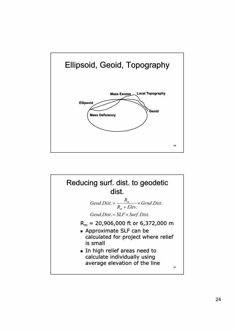
Ellipsoid, Geoid, TopographyEllipsoid, Geoid, Topography
Local TopographyLocal Topography
GeoidGeoid
EllipsoidEllipsoid
Mass DeficiencyMass Deficiency
Mass ExcessMass Excess
4646
Reducing surf. dist. to geodetic Reducing surf. dist. to geodetic dist.dist.
.... DistGrndElevRR
DistGeod m u�
RRmm = 20,906,000 ft or 6,372,000 m= 20,906,000 ft or 6,372,000 m�� Approximate SLF can be Approximate SLF can be
calculated for project where relief calculated for project where relief llll
.....DistSurfSLFDistGeod
ElevRmu �
4747
is smallis small�� In high relief areas need to In high relief areas need to
calculate individually using calculate individually using average elevation of the lineaverage elevation of the line
25
Reducing Reducing geodgeod. dist. to grid dist.. dist. to grid dist.
kDistGeodDistGrid u . �� k is sometimes called SF (scale k is sometimes called SF (scale
factor)factor)�� k is calculated from equations or k is calculated from equations or
interpolated from tables in state interpolated from tables in state or NOAA documentsor NOAA documents
4848
Scale factor (Mercator)Scale factor (Mercator)
�� “k” based on longitude (E“k” based on longitude (EPP’)’)�� A single Scale Factor (SF), can be A single Scale Factor (SF), can be
picked for projects that are not large picked for projects that are not large (under ~8 km)(under ~8 km)
4949
26
Direct conversion from surf. dist. to Direct conversion from surf. dist. to grid dist.grid dist.
Grid Dist = Surf Dist x SLF x SF Grid Dist = Surf Dist x SLF x SF If l ti d E f th If l ti d E f th �� If average elevation and E for the If average elevation and E for the project are being used, multiply SLF project are being used, multiply SLF and SF and use it as the Grid Factor and SF and use it as the Grid Factor (GF)(GF)
�� Grid factor also sometimes called Grid factor also sometimes called “C bi d S l F t ” (CSF)“C bi d S l F t ” (CSF)
5050
“Combined Scale Factor” (CSF)“Combined Scale Factor” (CSF)�� SF converts from geodetic to gridSF converts from geodetic to grid�� GF converts from ground to gridGF converts from ground to grid
Grid AzimuthGrid Azimuth
Grid Az = Geod Az Grid Az = Geod Az -- JJ + Second + Second TTTermTerm
�� For most surveys Second For most surveys Second Term can be ignored (lines Term can be ignored (lines under 8 km)under 8 km)
5151
27
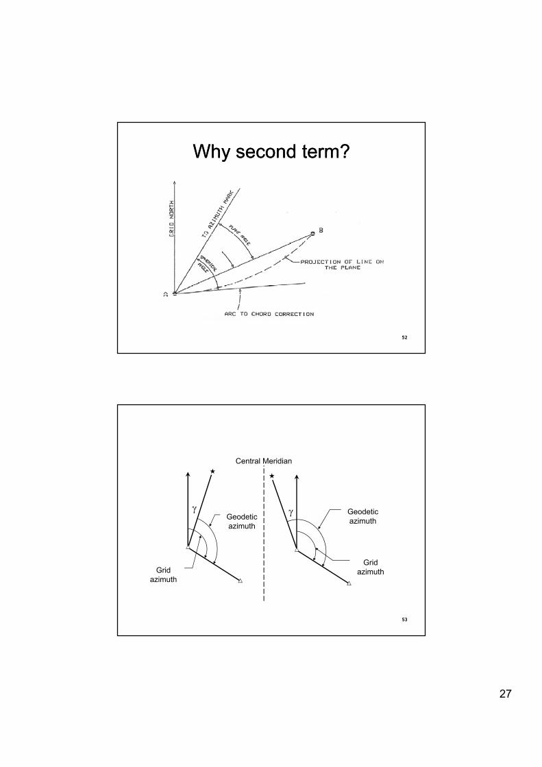
Why second term?Why second term?
5252
��
Central Meridian
J Geodetic azimuth
JGeodetic azimuth
5353
Grid azimuthGrid
azimuth
28
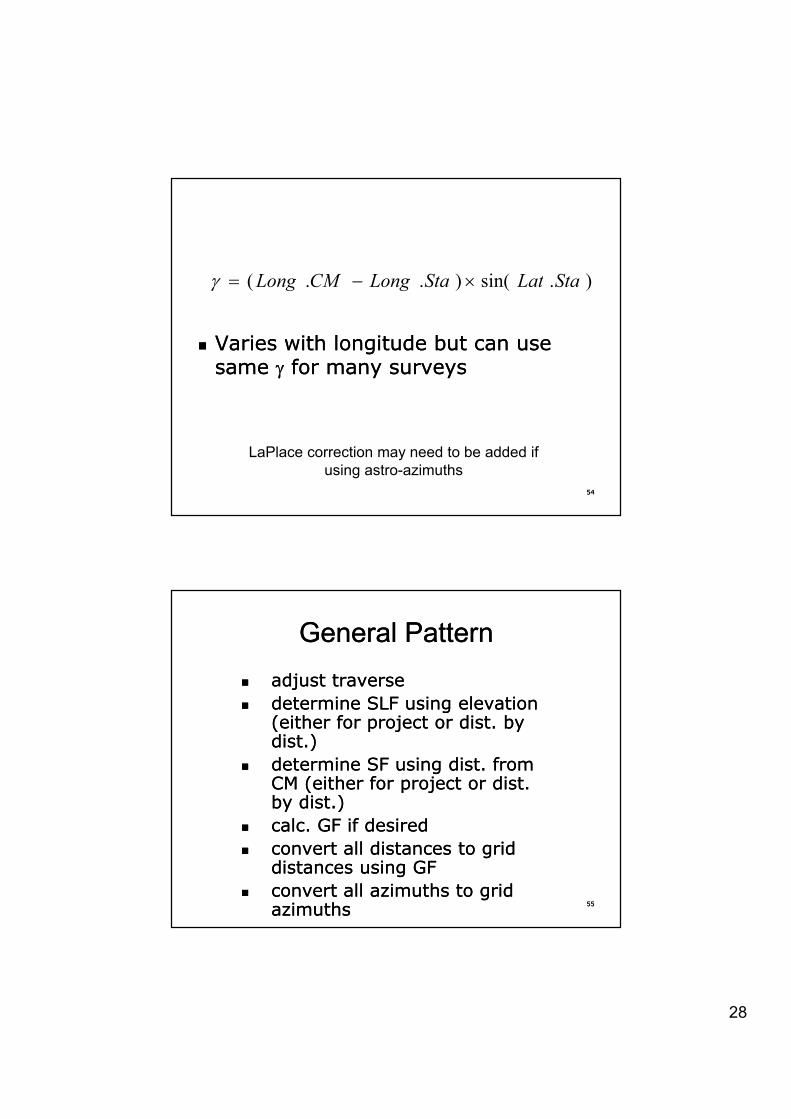
).sin()..( StaLatStaLongCMLong u� J
�� Varies with longitude but can use Varies with longitude but can use same same JJ for many surveysfor many surveys
)()( ggJ
5454
LaPlace correction may need to be added if using astro-azimuths
General PatternGeneral Pattern�� adjust traverseadjust traverse
determine SLF using elevation determine SLF using elevation �� determine SLF using elevation determine SLF using elevation (either for project or dist. by (either for project or dist. by dist.)dist.)
�� determine SF using dist. from determine SF using dist. from CM (either for project or dist. CM (either for project or dist. by dist.)by dist.)
5555
�� calc. GF if desiredcalc. GF if desired�� convert all distances to grid convert all distances to grid
distances using GFdistances using GF�� convert all azimuths to grid convert all azimuths to grid
azimuthsazimuths

29
General pattern / 2General pattern / 2
�� Assuming one of the traverse points Assuming one of the traverse points h k SPC l f th h k SPC l f th has a known SPC, calc of the has a known SPC, calc of the coordinates (SPC) of the other points coordinates (SPC) of the other points is straightforwardis straightforward
�� Always multiply distancesAlways multiply distances�� NEVER multiply coordinates!NEVER multiply coordinates!
5656
�� NEVER multiply coordinates!NEVER multiply coordinates!
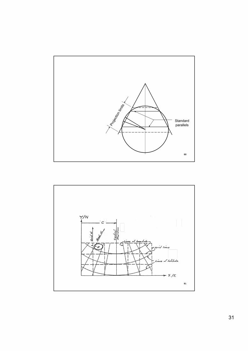
Lambert conformal conic projectionLambert conformal conic projection
�� Conformal: true angular relationships Conformal: true angular relationships are maintained around all points in are maintained around all points in are maintained around all points in are maintained around all points in small regionssmall regions
�� Scale varies north to south but not Scale varies north to south but not east to westeast to west
�� Secant lines, where scale is true, are Secant lines, where scale is true, are ll d ll d t d d ll lt d d ll l
5757
called called standard parallelsstandard parallels�� All geodetic meridians are straight, All geodetic meridians are straight,
converging at the poleconverging at the pole
30
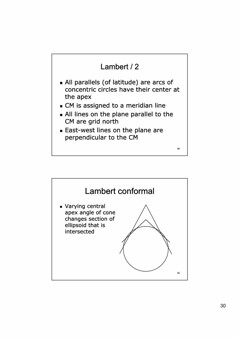
Lambert / 2Lambert / 2
�� All parallels (of latitude) are arcs of All parallels (of latitude) are arcs of t i i l h th i t t t i i l h th i t t concentric circles have their center at concentric circles have their center at
the apexthe apex�� CM is assigned to a meridian lineCM is assigned to a meridian line�� All lines on the plane parallel to the All lines on the plane parallel to the
CM are grid northCM are grid north
5858
CM are grid northCM are grid north�� EastEast--west lines on the plane are west lines on the plane are
perpendicular to the CMperpendicular to the CM
Lambert conformalLambert conformal
�� Varying central Varying central apex angle of cone apex angle of cone apex angle of cone apex angle of cone changes section of changes section of ellipsoid that is ellipsoid that is intersectedintersected
5959
31
Standard parallels
6060
p
6161

32
Mapping angleMapping angle
�� Also called grid declination or Also called grid declination or i tii tivariationvariation
�� Greek letter Greek letter -- TT [theta][theta]
6262
Calculations (Lambert)Calculations (Lambert)
�� Same as for Transverse Mercator Same as for Transverse Mercator ttexcept…except…
�� Tables for the zone have the value Tables for the zone have the value
lStaLongCMLongAzGeodAzGrid
u� �
.)..(....
TT
6363
of the long. of the CM and of the long. of the CM and ll�� General pattern for calcs is the General pattern for calcs is the
samesame
33
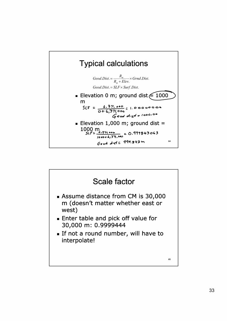
Typical calculationsTypical calculations
...
.. DistGrndElevRR
DistGeodm
m u�
�� Elevation 0 m; ground dist = 1000 Elevation 0 m; ground dist = 1000 mm
.... DistSurfSLFDistGeodm
u
6464
�� Elevation 1,000 m; ground dist = Elevation 1,000 m; ground dist = 1000 m1000 m
Scale factorScale factor
�� Assume distance from CM is 30,000 Assume distance from CM is 30,000 (d ’t tt h th t (d ’t tt h th t m (doesn’t matter whether east or m (doesn’t matter whether east or
west)west)�� Enter table and pick off value for Enter table and pick off value for
30,000 m: 0.999944430,000 m: 0.9999444�� If not a round number will have to If not a round number will have to
6565
�� If not a round number, will have to If not a round number, will have to interpolate!interpolate!
34
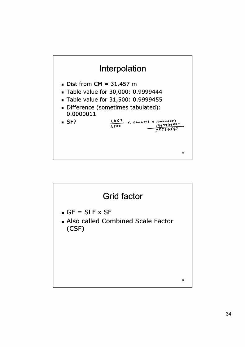
InterpolationInterpolation
�� Dist from CM = 31,457 mDist from CM = 31,457 mT bl l f 30 000 0 9999444T bl l f 30 000 0 9999444�� Table value for 30,000: 0.9999444Table value for 30,000: 0.9999444
�� Table value for 31,500: 0.9999455Table value for 31,500: 0.9999455�� Difference (sometimes tabulated): Difference (sometimes tabulated):
0.00000110.0000011�� SF?SF?
6666
Grid factorGrid factor
�� GF = SLF x SFGF = SLF x SF�� Also called Combined Scale Factor Also called Combined Scale Factor
(CSF)(CSF)
6767
35
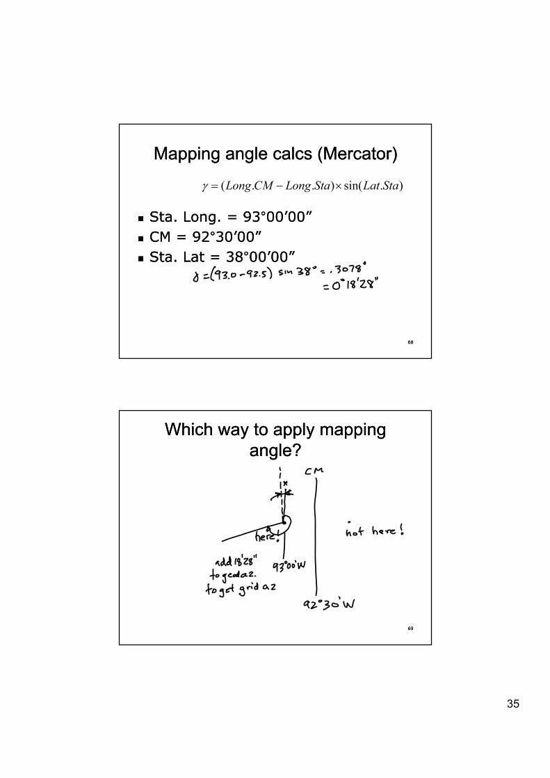
Mapping angle calcs (Mercator)Mapping angle calcs (Mercator)
).sin()..( StaLatStaLongCMLong u� J
�� Sta. Long. = 93Sta. Long. = 93°°00’00”00’00”�� CM = CM = 9292°°30’00”30’00”�� Sta. Lat = Sta. Lat = 3838°°00’00”00’00”
6868
Which way to apply Which way to apply mapping mapping angle?angle?
6969
36
Practical usePractical use
�� Tie in to monuments with SPCs, Tie in to monuments with SPCs, therefore don’t need to calculate therefore don’t need to calculate therefore don t need to calculate therefore don t need to calculate mapping anglemapping angle
�� Project coordinates sometime usedProject coordinates sometime used——be careful!be careful!
�� On plats show SPCs. If you must On plats show SPCs. If you must h d di t h d di t h id h id
7070
show ground distances, show ground distances, show grid show grid distances also!distances also!
�� Meta data!Meta data!
WhewWhew
�� How to use?How to use?M ti ll id ( di t ) M ti ll id ( di t ) �� My suggestion: use all grid (coordinates) My suggestion: use all grid (coordinates) or all ground (distances)or all ground (distances)
�� If all ground distances, publish a table of If all ground distances, publish a table of grid coordinates of all the pointsgrid coordinates of all the points
�� If all grid coordinates, publish a table of all If all grid coordinates, publish a table of all d d di tdi t d if d i d d if d i d
7171
ground ground distancesdistances and, if desired, and, if desired, azimuths/bearings on nonazimuths/bearings on non--grid basisgrid basis
37
Grid vs. groundGrid vs. ground
�� DO NOT publish “ground DO NOT publish “ground di t ” l X d Y l di t ” l X d Y l coordinates” unless X and Y values coordinates” unless X and Y values
are readily differentiableare readily differentiable�� On the plat if you show ground On the plat if you show ground
values and grid values use a suffix or values and grid values use a suffix or prefix (GRID & ground)prefix (GRID & ground)
7272
prefix (GRID & ground)prefix (GRID & ground)
Grid vs. groundGrid vs. ground
�� If you have to, use different fonts or If you have to, use different fonts or diff t t l ( l diff t t l ( l it li )it li )different styles (regular vs. different styles (regular vs. italics)italics)
�� But make sure they can be easily But make sure they can be easily differentiateddifferentiated
�� Do NOT use different colors Do NOT use different colors to to differentiate; remember differentiate; remember that that
7373
differentiate; remember differentiate; remember that that whatever you prepare may become whatever you prepare may become monochromemonochrome
38
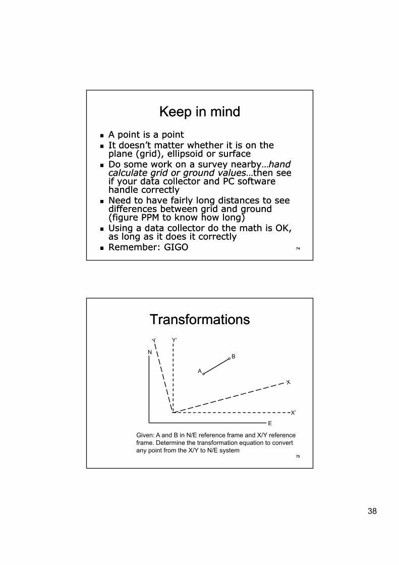
Keep in mindKeep in mind�� A point is a pointA point is a point�� It doesn’t matter whether it is on the It doesn’t matter whether it is on the �� It doesn t matter whether it is on the It doesn t matter whether it is on the
plane (grid), ellipsoid or surfaceplane (grid), ellipsoid or surface�� Do some work on a survey nearby…Do some work on a survey nearby…hand hand
calculate grid or ground valuescalculate grid or ground values…then see …then see if your data collector and PC software if your data collector and PC software handle correctlyhandle correctly
�� Need to have fairly long distances to see Need to have fairly long distances to see
7474
y gy gdifferences between grid and ground differences between grid and ground (figure PPM to know how long)(figure PPM to know how long)
�� Using a data collector do the math is OK, Using a data collector do the math is OK, as long as it does it correctlyas long as it does it correctly
�� Remember: GIGORemember: GIGO
TransformationsTransformations
N
Y’
B
X’
A
B
7575
E
X’
Given: A and B in N/E reference frame and X/Y reference frame. Determine the transformation equation to convert any point from the X/Y to N/E system
39
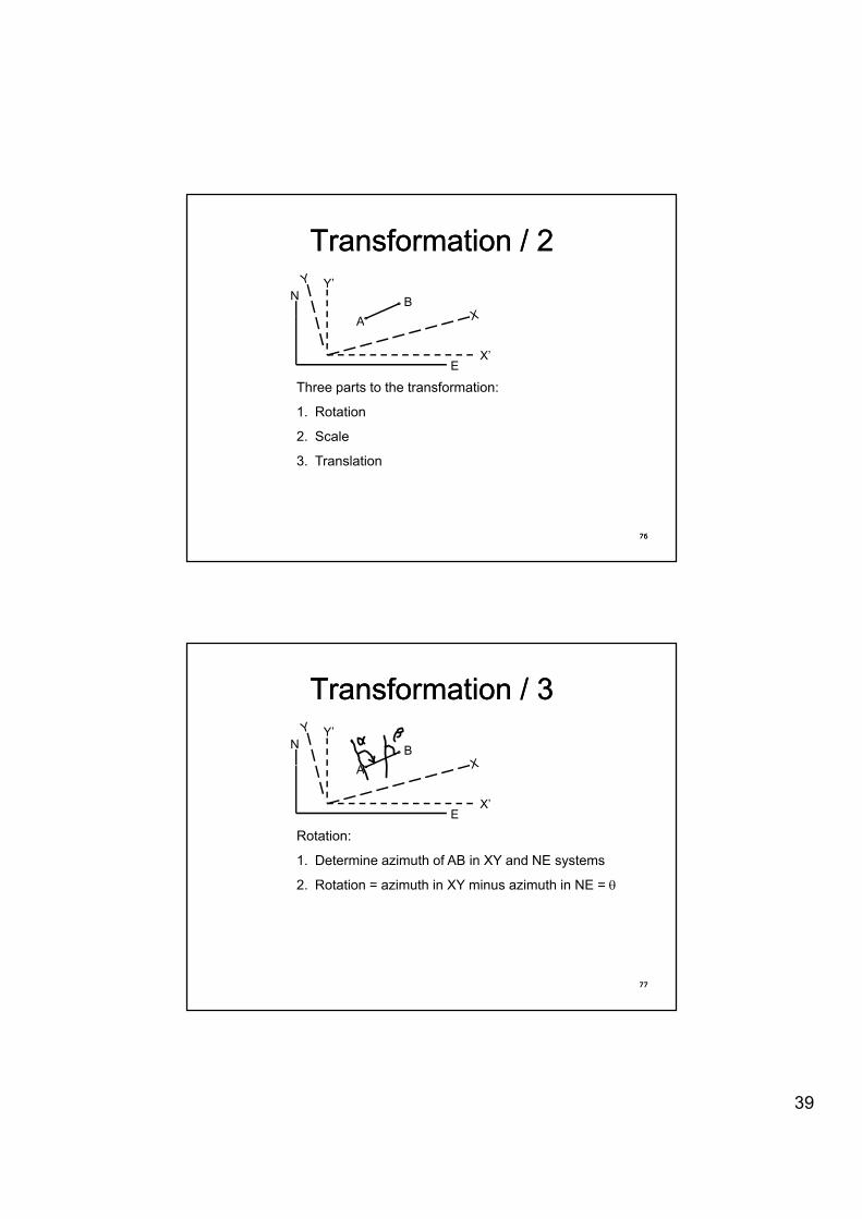
Transformation / 2Transformation / 2N
Y’
AB
EX’
A
Three parts to the transformation:
1. Rotation
2 Scale
7676
2. Scale
3. Translation
Transformation / 3Transformation / 3N
Y’
AB
EX’
A
Rotation:
1. Determine azimuth of AB in XY and NE systems
2 Rotation = azimuth in XY minus azimuth in NE = T
7777
2. Rotation azimuth in XY minus azimuth in NE T
40
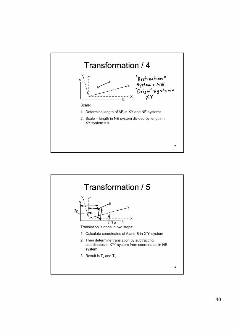
Transformation / 4Transformation / 4N
Y’
AB
EX’
A
Scale:
1. Determine length of AB in XY and NE systems
2 Scale = length in NE system divided by length in
7878
2. Scale length in NE system divided by length in XY system = s
Transformation / 5Transformation / 5N
Y’
AB
EX’
A
Translation is done in two steps:
1. Calculate coordinates of A and B in X’Y’ system
2 Then determine translation by subtracting
7979
2. Then determine translation by subtracting coordinates in X’Y’ system from coordinates in NE system
3. Result is Tx and TY
41
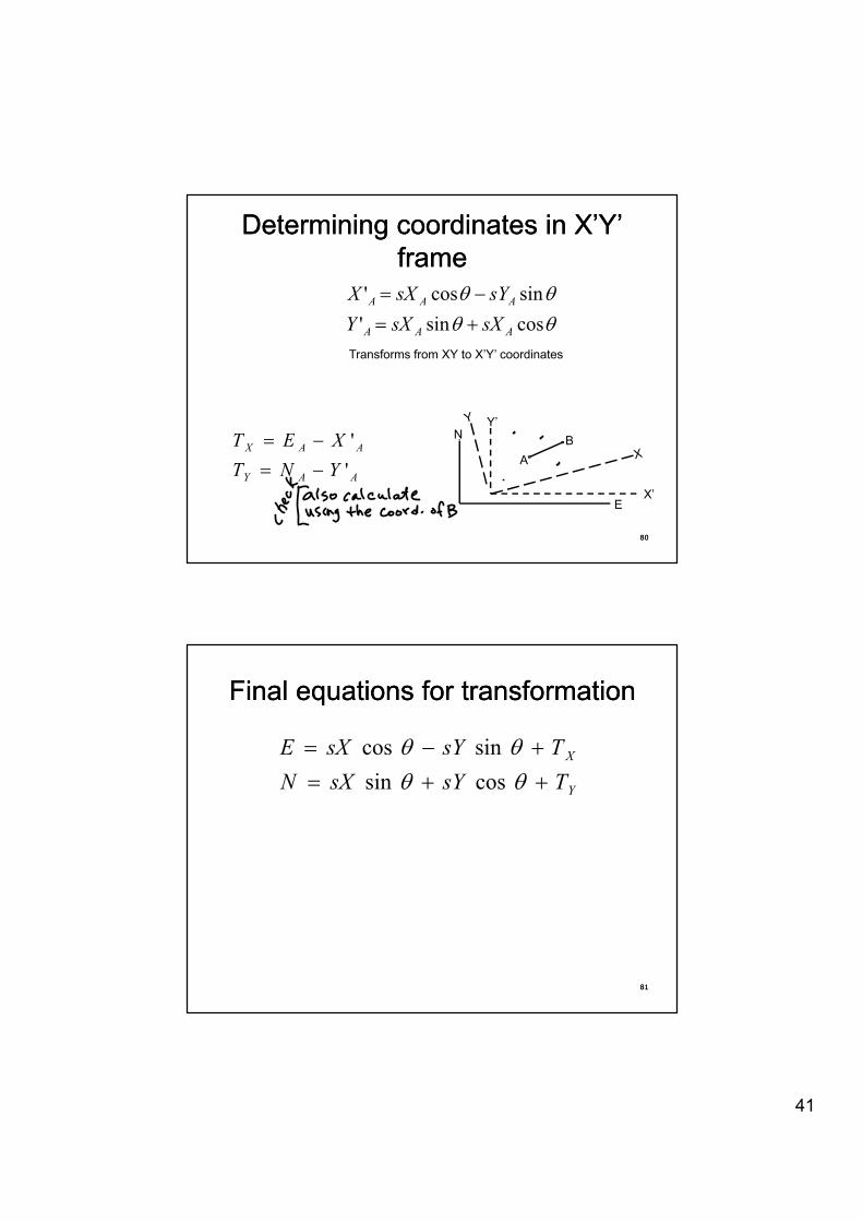
Determining coordinates in X’Y’ Determining coordinates in X’Y’ frameframe
TTTT
i'sincos' AAA
XXYsYsXX �
TT cossin' AAA sXsXY � Transforms from XY to X’Y’ coordinates
NY’
BXET '
8080
EX’
AB
AAY
AAX
YNTXET
'� �
Final equations for transformationFinal equations for transformation
XTsYsXE �� TT sincos
YTsYsXN �� TT cossin
8181
42
Questions?Questions?Questions?Questions?
8282
About&the&seminar&presenter& Joseph V.R. Paiva, PhD, PS, PE Joseph V. R. Paiva, is a consultant in the field of geomatics and general business, particularly to international developers, manufacturers and distributors of instrumentation and other geomatics tools. His career includes: managing director of Spatial Data Research, Inc., a GIS data collection, compilation and software development company; various assignments at Trimble Navigation Ltd. including senior scientist and technical advisor for Land Survey research & development, VP of the Land Survey group, and director of business development for the Engineering and Construction Division; vice president and a founder of Sokkia Technology, Inc., guiding development of GPS- and software-based products for surveying, mapping, measurement and positioning. He has also held senior technical management positions in The Lietz Co. and Sokkia Co. Ltd. Prior to that was assistant professor of civil engineering at the University of Missouri-Columbia, and a partner in a surveying/civil engineering consulting firm. He has continued his interest in teaching by serving as an adjunct instructor at the Missouri University of Science and Technology. His key contributions in the development field are: design of software flow for the SDR2, SDR20 series and SDR33 Electronic Field Books; software interface for the Trimble TTS500 total station. He is a Registered Professional Engineer and Professional Land Surveyor, has served as ACSM representative to the Accrediting Board for Engineering and Technology (ABET), serving as a program evaluator, team chair, and commissioner and has more than 30 years experience working in civil engineering, surveying and mapping. He writes for POB and The Empire State Surveyor magazines and has been a past contributor of columns to Civil Engineering News. As a consultant to the Geomatics Industry Association of America, later reorganized under the Association of Equipment Manufacturers (AEM) as the Geospatial Industry Group, Joe has organized and presented workshops and authored and edited articles for the technical press. He is currently working on a practitioner’s guide to the optimal use of total stations. Joe can be contacted at [email protected]; mobile phone 1-816-225-7163; Skype: joseph_paiva. Mailing address: P.O. Box 7247, Kansas City, MO 64113-0247.
Jan 2012