the zambezi river valley and surrounding areas, july, 2011
TRANSCRIPT
Seasonal Biomass Burning in Africa and its effects on air quality: a study
of AOD in 2008-2010 with some comments on long-range transport
The Zambezi River Valley and surrounding areas, July, 2011.

with
Ben Sumlin
MODIS above the Democratic Republic of Congo, May 16, 2002.

Biomass Burning in Africa
• Divided in to two regions– Northern burns occur January-April– Southern burns occur May-August
• No reliable Aeronet data for southern regions
• Agricultural Reasons– Clear fields for new crops– Fertilize soil
• Consequences– Long-range transport

Motivation for this Case Study
• Compare satellite data against ground-based data to determine assess validity of both
• Explore yearly trends and anomalies at Ilorin, Africa, located in the heart of the northern burn areas
• Ascension Island

Two Aeronet Stations
• Ilorin, Africa– 8N, 4E– Right in the heart of burn country
• Ascension Island– 15S, 23W– Monitor offshore transport
• Largely incomplete data set
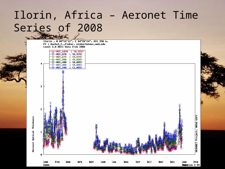
Ilorin, Africa – Aeronet Time Series of 2008

Ilorin, Africa – MODIS area-averaged time series of 2008

Ilorin, Africa – February 28, 2008

Ilorin – September 16, 2008

Ilorin, Africa – Aeronet 2009
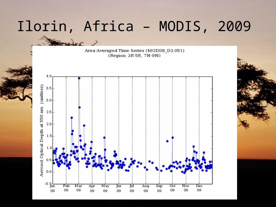
Ilorin, Africa – MODIS, 2009

Ilorin, Africa – February 14, 2009

Ilorin, Africa – Aeronet 2010

Ilorin, Africa – MODIS, 2010
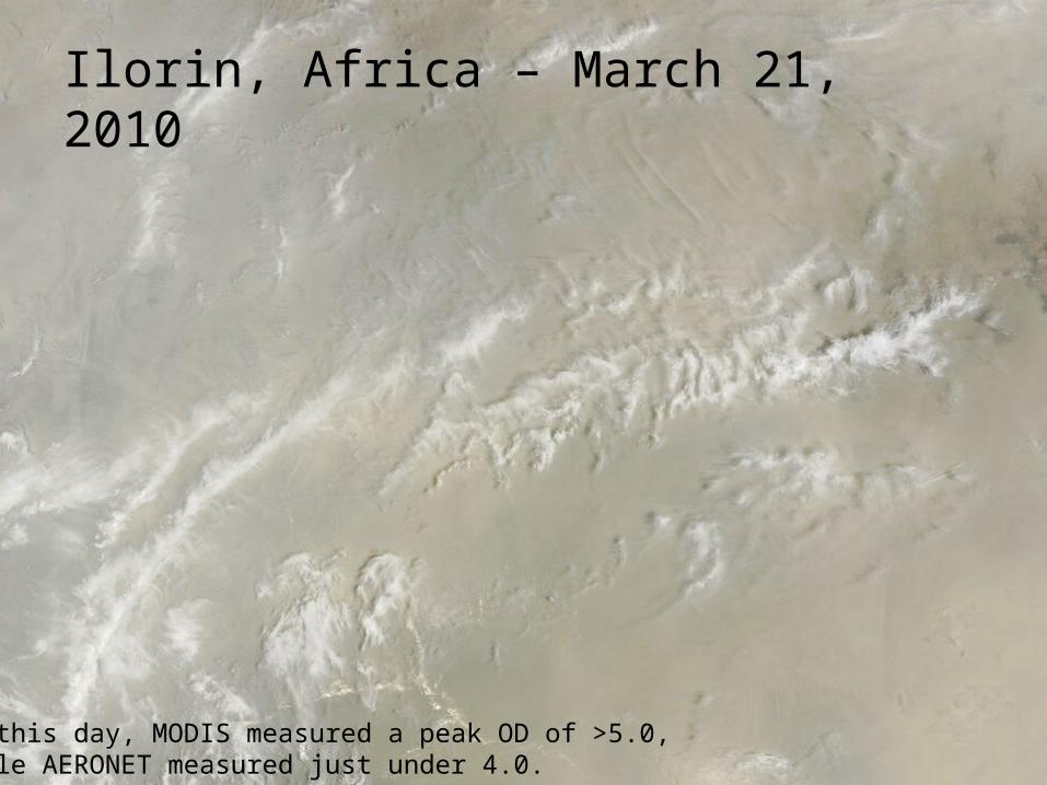
Ilorin, Africa – March 21, 2010
On this day, MODIS measured a peak OD of >5.0,while AERONET measured just under 4.0.

MODIS vs. Aeronet at Ilorin
• 2008– Reasonable correlation, even during anomalies
• 2009– AOD spike on February 14
• MODIS: 4.0• AERONET: 2.5.
• 2010– AOD spike on March 21
• MODIS: >5.0• AERONET: <4.0

Seasonal Trends
• AOD trends were identified consistent with the burning seasons

Offshore transport:Ascension Island

Ascension Island: ~7S, 14W
• Small volcanic island in the Pacific Ocean– Under the jurisdiction of the UK
• Communications hub• AERONET site
– Sparse dataset
• We expect to see AOD spikes over Ascension Island during the southern burn months.– More pronounced transport over the island;
Northern burn emissions pass to the North of the island.

Prevailing Wind Patterns off Africa

Ascension Island – Aeronet time series for 2008

Ascension Island – MODIS area-averaged time series for 2008

Ascension Island – September 27, 2008

Ascension Island – Aeronet, 2009

Ascension Island – MODIS, 2009

Ascension Island – September 19, 2009

Ascension Island – Aeronet, 2010
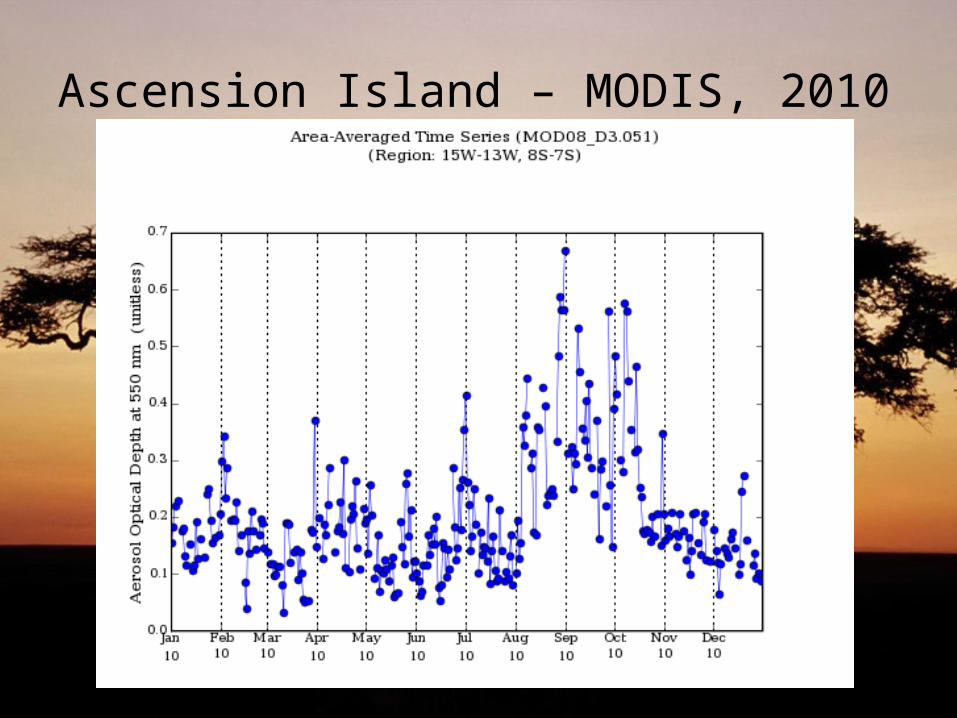
Ascension Island – MODIS, 2010
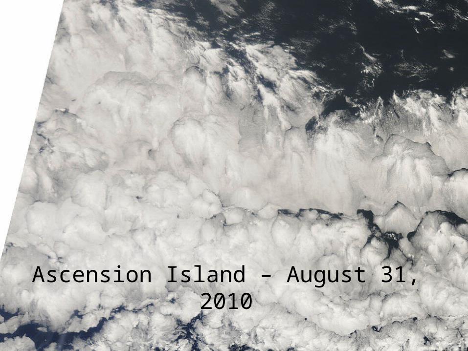
Ascension Island – August 31, 2010

MODIS vs. Aeronet at Ascension Island
• Sparse 1.5 and 2.0 Aeronet datasets make comparisons difficult– Cloud cover– Some transport possibly identified
• Inconsistencies in datasets– Level 1.5 vs. level 2.0

Comments on discrepancies
• Sources of error– Area-averaging
• Single column integrated measurement vs. area-averaged measurement
– Algorithms– Discarded data
• Ascension Island enjoys cloudy weather• Cloud readings are rejected by CIMEL stations.