the weather aspect of disaster planning and preparedness ... · the weather aspect of disaster...
TRANSCRIPT
Reprint 539
The Weather Aspect of Disaster Planning
and Preparedness in Hong Kong
C. Y. Lam
Symposium on Planning and Preparedness for
Weather-related Disasters, Hong Kong, China, 29-30 March 2004
1
The Weather Aspect of Disaster Planning and Preparedness in Hong Kong
C Y Lam Hong Kong Observatory
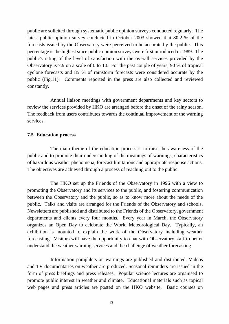
1. Introduction Weather-related disasters in Hong Kong are mostly the results of tropical cyclones and rainstorms. On top of casualties, these events could result in considerable economic loss and disruptions to social activities. More than US$ 45 million (~HK$350 million) of direct economic losses were reported due to tropical cyclones, rainstorms, floods and landslides during the past decade. In step with the rapid development of Hong Kong as an international metropolis in the past half century, the Hong Kong Observatory (HKO) has expended much effort to improve the timeliness and reliability of weather warnings to ensure public safety and to minimise loss in weather-induced disasters. As a result of reliable warnings, timely information dissemination, persistent public education and improved coordination, losses and casualties in tropical cyclones, rainstorms, floods and landslides in Hong Kong have decreased substantially. The annual numbers of casualties due to tropical cyclones over the years are shown in Fig. 1. In 1962, more than 180 people were reported dead or missing due to tropical cyclones. By contrast, Typhoon York hit in 1999 necessitating the hoisting of the No. 10 signal, but only two were lost. The tropical cyclone warning system has evolved during the period to become a well-trusted trigger for the organized response of the government and the community as a whole whenever tropical cyclones pose a threat. 2. The HKSAR Government Contingency Plan for Natural Disasters The success in reducing of casualties in Hong Kong is achieved principally through improvements in the effectiveness of planning and preparedness for weather-related disasters. A holistic approach focusing on reducing vulnerabilities and preventing disasters rather than reacting to hazards is adopted. In this approach, the process of planning, preparation and implementation is the coordinated effort of the government, emergency response units, weather services, the private sector and the general public.
2
The comprehensive HKSAR Government Contingency Plan for Natural Disasters (CPND) provides a proven framework for emergency responses in weather-related disasters. A bottom-up approach is adopted in which the emergency response is kept as simple as possible by limiting the number of departments and agencies involved. It minimises the amount of communication within the emergency response system, and delegates necessary authority and responsibility to those at the scene of an emergency.
The CPND summarizes the Government’s alerting system and organizational framework for responding to natural disasters. The plan stipulates the triggering mechanisms of the alerting system, spells out the responsibilities of various bureaux and departments as well as non-government organizations in responding to specific types of severe weather warnings relating to tropical cyclones, rainstorms, flooding, landslip and thunderstorms. More than 20 bureaux/departments/agencies are involved in this plan as response units. The HKO, one of the key player of the CPND, issues weather warnings, together with advice on precautions, to the media and key Government departments through a robust network. The weather information is transmitted by the Information Services Department (ISD) to other Government departments and parties according to an alerting system in the plan so as to ensure effective dissemination. The HKO is also proactive in keeping the government’s Emergency Monitoring and Support Centre (EMSC) and other relevant departments fully informed about imminent severe weather in a timely manner, to enable them to make good advance preparations for the public’s reactions to HKO warnings broadcast by the media.
To ensure a smooth and effective flow of disaster-related information, the CPND also clearly states the controlling authorities in the rescue, recovery and restoration phases, with an emphasis on direct liaison and coordination among relevant working parties. In the event of a major incident involving widespread threats to life, property and security and where extensive Government emergency response operations are required, the EMSC is activated upon the direction of the Secretary for Security. On activation, EMSC is charged with establishing links with the HKO, ISD, Home Affairs Department, Police , Fire Services, Government Flying Service, Civil Engineering Department, Drainage Services Department, Highways Department, Environment, Transport and Works Bureau, Transport Department, Lands Department, Marine Department, Housing Authority, Education and Manpower Bureau, Social Welfare Department and other relevant parties.
3
Regular communication exercises are held to evaluate the effectiveness of the alerting mechanism and the communication links among key bureaux/departments. In addition to the contingency plan, close cooperation among disaster management organizations, effective communication and a well-established public information/education programme together contribute to making Hong Kong resistant in the fall of disasters.
3. Guiding Thoughts regarding Weather Warning Systems
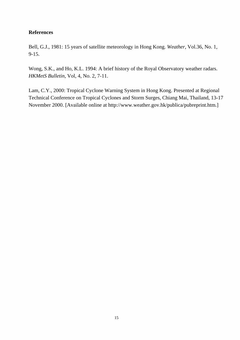
Central to the CPND is a suite of weather warning systems operated by the HKO. To be useful to disaster prevention and preparedness, a severe weather warning system is more than just a set of definitions of different "warning status" or the warning criteria. The concept of “warning” includes communicating relevant information to the intended audience so as to enable them to take appropriate responsive actions to avoid danger or to minimize risk. The form which a warning system takes depends on the state of the meteorological science, the technological means of communication available, the built environment including dwellings and transport infrastructure, and most importantly, on the expectations of the society (Fig.2). The key requirements of a good warning system are (a) easy to understand, (b) facilitating collective and effective response by the community, and (c) meeting the expectations of the society. These points are illustrated by a number of the warnings as discussed in sections 4 - 8 below. 4. Tropical Cyclone Warning System
The tropical cyclone warning system in Hong Kong has been in existence since 1884. At that time, Hong Kong was a small fishing and trading port and the focus in typhoon passage was on casualties. Over the past half century, Hong Kong has evolved into a fast-pace modern metropolis with a vibrant economy. The public has evolved into numerous sectors with diversified interests and requirements. A wide range of activities, including economic ones, are affected by severe weather. While the loss of lives due to tropical cyclones has decreased with time, the economic losses have risen significantly. The commercial sector is becoming increasingly intolerant of over-warning in the face of perceived economic loss. The general public on the other hand is extremely critical of under-warning and nowadays would not accept the loss of a single life (Lam, 2000). The tropical cyclone warning system has evolved with time, adjusting itself to changing needs and availing itself to emerging technologies. This evolution is
4
sketched below to illustrate how various factors have interplayed to determine the form of the warning system at the time. 4.1 The Early Years up to 1950’s
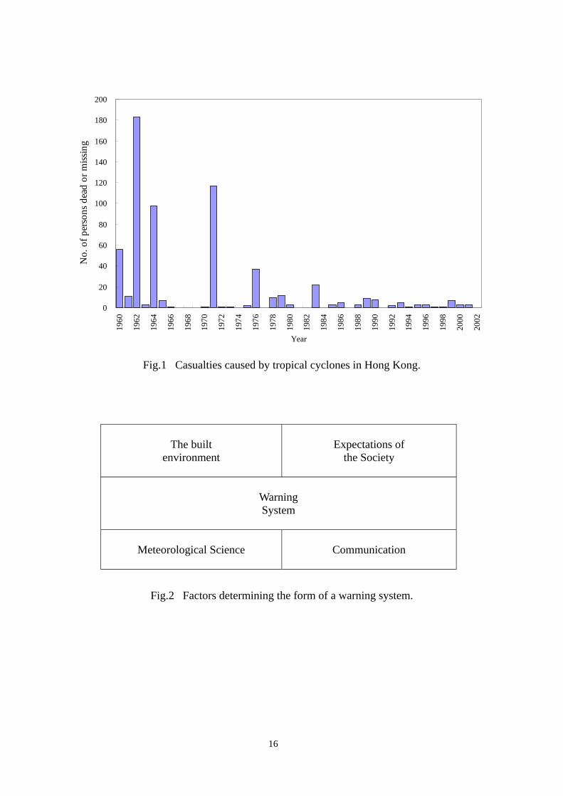
Many people in Hong Kong lived in boats and flimpsy huts. Destructive winds from typhoons were the prime concern and simplicity was the key requirement of the tropical cyclone warning system.
The HKO established its first tropical cyclone warning system in 1884, which was aimed at giving information to the mariners in port. A system of visual signals viz. drum, ball and cone gave indications of the existence and approximate location of a tropical cyclone. It was modified into a numbered signal system in 1917, to give warnings to the local public of wind conditions in Hong Kong. Various changes were made from time to time. By 1973, it settled down into the pattern still in use today (Table 1).
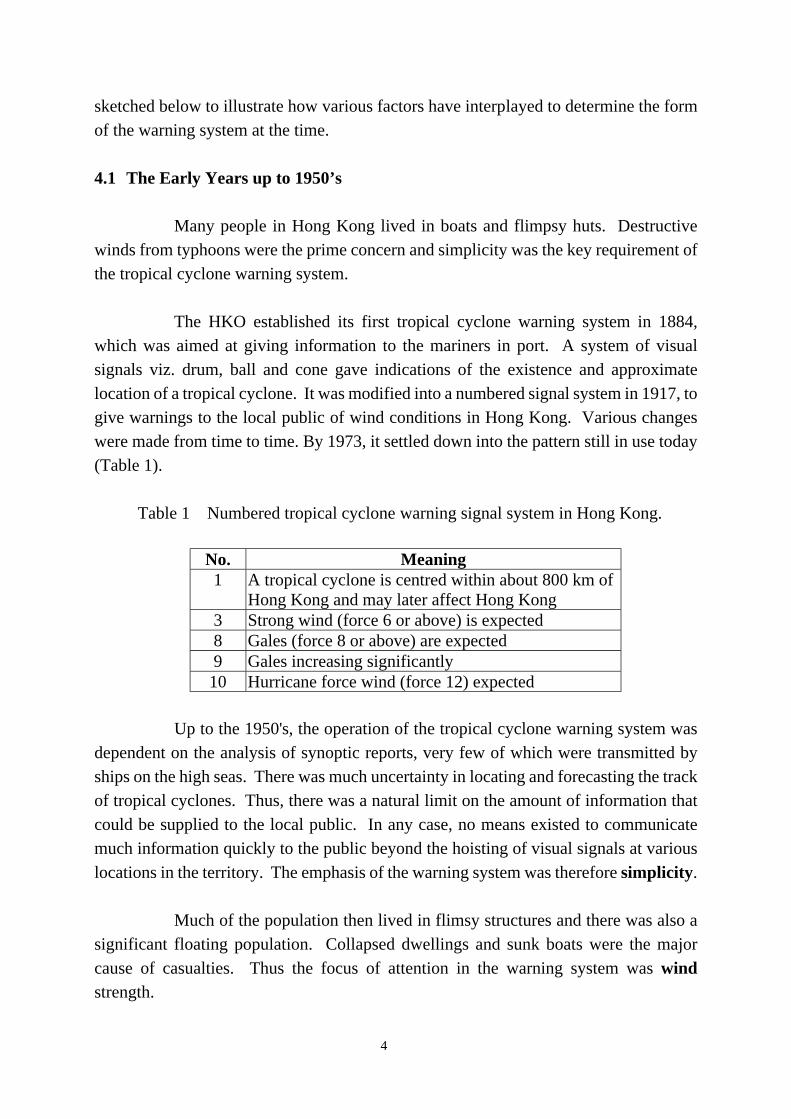
Table 1 Numbered tropical cyclone warning signal system in Hong Kong.
No. Meaning 1 A tropical cyclone is centred within about 800 km of
Hong Kong and may later affect Hong Kong 3 Strong wind (force 6 or above) is expected 8 Gales (force 8 or above) are expected 9 Gales increasing significantly
10 Hurricane force wind (force 12) expected Up to the 1950's, the operation of the tropical cyclone warning system was dependent on the analysis of synoptic reports, very few of which were transmitted by ships on the high seas. There was much uncertainty in locating and forecasting the track of tropical cyclones. Thus, there was a natural limit on the amount of information that could be supplied to the local public. In any case, no means existed to communicate much information quickly to the public beyond the hoisting of visual signals at various locations in the territory. The emphasis of the warning system was therefore simplicity.
Much of the population then lived in flimsy structures and there was also a significant floating population. Collapsed dwellings and sunk boats were the major cause of casualties. Thus the focus of attention in the warning system was wind strength.
5
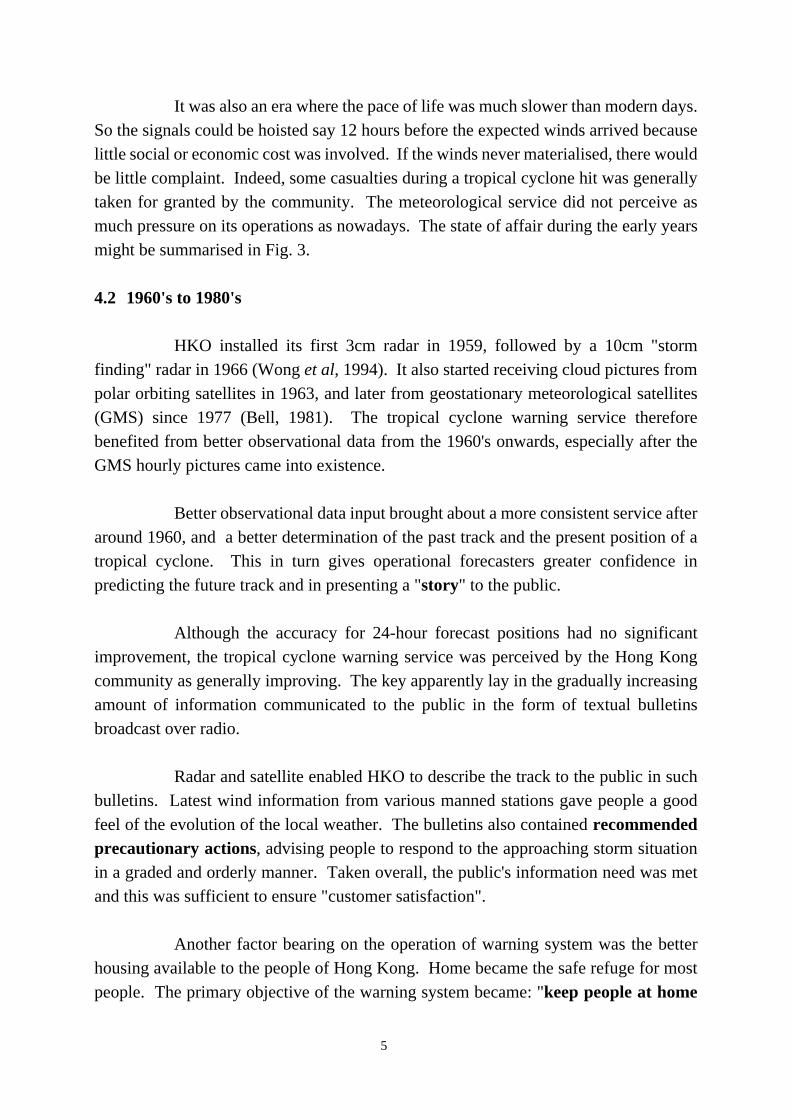
It was also an era where the pace of life was much slower than modern days. So the signals could be hoisted say 12 hours before the expected winds arrived because little social or economic cost was involved. If the winds never materialised, there would be little complaint. Indeed, some casualties during a tropical cyclone hit was generally taken for granted by the community. The meteorological service did not perceive as much pressure on its operations as nowadays. The state of affair during the early years might be summarised in Fig. 3. 4.2 1960's to 1980's
HKO installed its first 3cm radar in 1959, followed by a 10cm "storm finding" radar in 1966 (Wong et al, 1994). It also started receiving cloud pictures from polar orbiting satellites in 1963, and later from geostationary meteorological satellites (GMS) since 1977 (Bell, 1981). The tropical cyclone warning service therefore benefited from better observational data from the 1960's onwards, especially after the GMS hourly pictures came into existence.
Better observational data input brought about a more consistent service after around 1960, and a better determination of the past track and the present position of a tropical cyclone. This in turn gives operational forecasters greater confidence in predicting the future track and in presenting a "story" to the public.
Although the accuracy for 24-hour forecast positions had no significant improvement, the tropical cyclone warning service was perceived by the Hong Kong community as generally improving. The key apparently lay in the gradually increasing amount of information communicated to the public in the form of textual bulletins broadcast over radio. Radar and satellite enabled HKO to describe the track to the public in such bulletins. Latest wind information from various manned stations gave people a good feel of the evolution of the local weather. The bulletins also contained recommended precautionary actions, advising people to respond to the approaching storm situation in a graded and orderly manner. Taken overall, the public's information need was met and this was sufficient to ensure "customer satisfaction".
Another factor bearing on the operation of warning system was the better housing available to the people of Hong Kong. Home became the safe refuge for most people. The primary objective of the warning system became: "keep people at home
6
before high winds strike". A tradition eventually emerged in which schools would close and people would be released from work if a number 8 signal was hoisted during office hours. Or if the signal was hoisted before school and office started, people would stay home. This was a simple but very effective measure; the number of casualties due to tropical cyclones dropped significantly through the years, as is evident in Fig. 1. However, this translated into another demand from the public - HKO would be flooded by enquiries on whether the hoisting of the number 8 was imminent. To this demonstrated information need, HKO responded in 1987 after much reluctance and trepidation by starting to give a 2-hour advance alert to government departments, transport operators and the public whenever that the signal number 8 would be hoisted. To the pure scientist, this would appear to be an awkward and illogical step to take. But the public took it as an improvement, showing that the meteorological service care about them.
The caring image was further strengthened by the deployment of professional meteorologists to deliver regular briefings on approaching tropical cyclones on television. Such TV appearances reassured the public that HKO professionals were in control of the situation. By the careful choice of words spoken by the meteorologists, TV viewers would feel that they received advice from HKO people directly. This sense of direct contact was instrumental in nurturing rapport between HKO and the public.
One final aspect about the period was the faster pace of life associated with the developing and booming economy. By 1980, it was becoming clear that the sophistication of the population and the better transport system generally enabled the community to respond swiftly to warning signals and to complete necessary precautions. In line with this development and without a conscious decision being made at the time, HKO gradually operated the signals allowing less false alarms, that is, less lead time before the expected wind strength was reached. This was aided to a great extent by the hourly GMS pictures available since the late 1970's. We may represent the situation for the 1960's to the 1980's schematically in Fig. 4.
4.3 1990's to 2000’s
The 1990's saw Hong Kong's transformation into an international metropolis with a complex array of economic activities running at a fast pace round the clock. Paradoxically, the city became more vulnerable to tropical cyclones and its associated weather. It was not just a question of casualties. A wide range of economic activities
7
were affected by weather. For example, the container port which is among the busiest in the world would scale down or even stop operation in force 6 winds. A number 8 signal indicating force 8 winds would cause banks, the stock exchange, courts, schools, most offices and shops to close and buses and ferries to stop running. That is, the city would come to a standstill.
The Hong Kong society has become very intolerant of both over-warning and under-warning. The better educated population is more ready than ever to complain and knows how to do it with effectiveness. The tropical cyclone warning system is therefore under microscopic examination by different sectors of the community, each with their own interest, every time a tropical cyclone hit Hong Kong. This put enormous pressure on HKO.
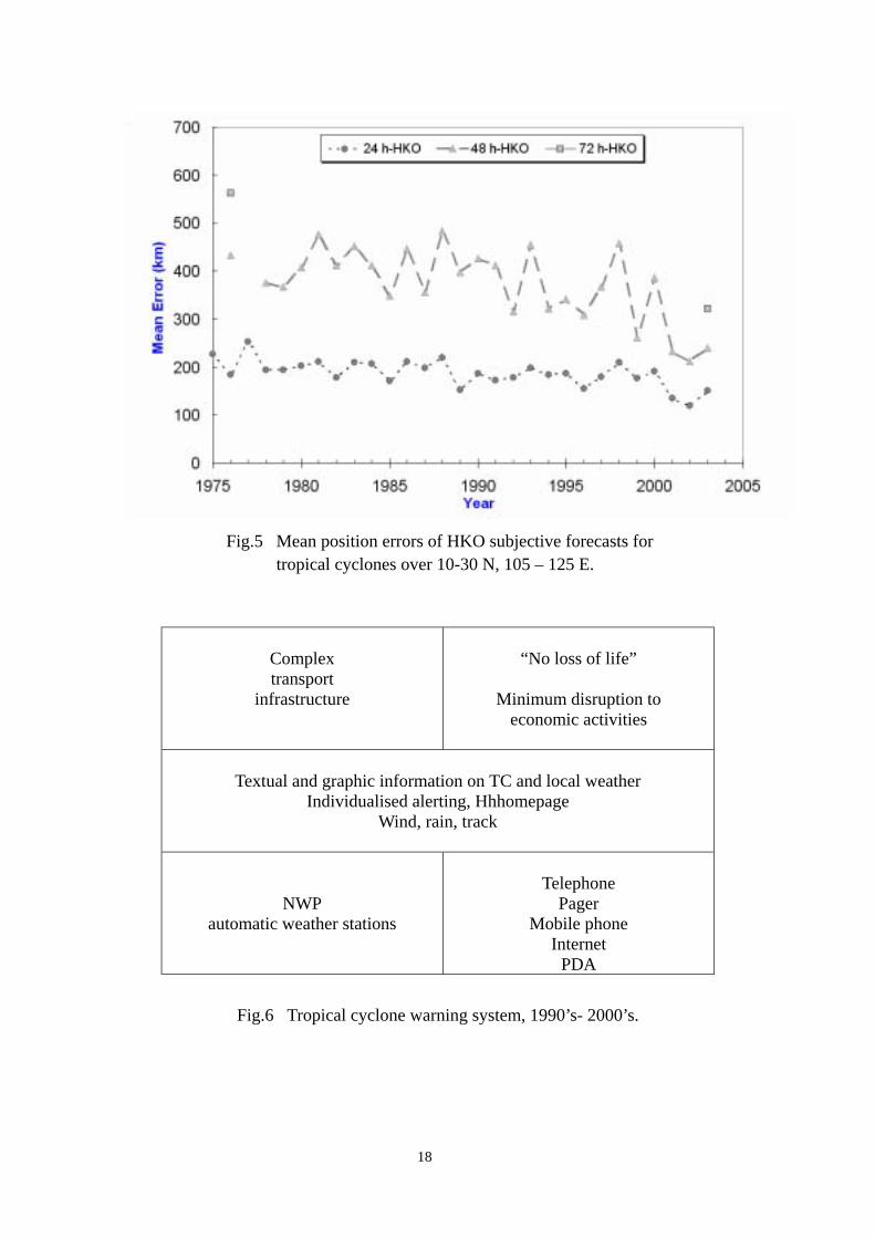
Fortunately, numerical weather prediction (NWP) has come of age. Towards the end of the decade, operational NWP models began showing significant skill in tropical cyclone track predicting up to 72 hours (Fig. 5). It enabled forecasters to anticipate the forecast tropical cyclone scenario in the next couple of days and to communicate it to the public. The addition of this information to the weather bulletins was a great boost to the image of HKO, because it was badly needed information for those who would like to plan ahead.
On the delivery of warning information to the public, HKO was greatly
helped by the successive emergence of pagers, mobile phones and the internet. Millions of people would know about changes in warning status virtually in minutes. It was a new age in which individual alerting became possible. The internet also revolutionized the delivery process by enabling the transmission of graphic information such as predicted tropical cyclone tracks and real-time weather situation in Hong Kong.
With tropical cyclone track charts and automatic weather station
information available online, the intelligent members of the public could now make their own judgement about what to do as a tropical cyclone approaches. To them, the conventional warning signal system has a diminishing role in guiding their responsive actions. The situation of the tropical cyclone warning service in late 1990's and early 2000's is represented schematically in Fig. 6.
8
5. Rainstorm Warning System
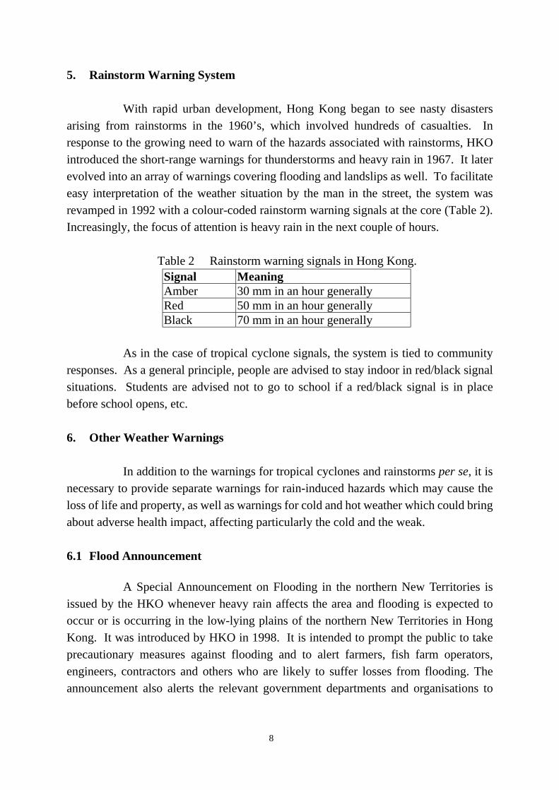
With rapid urban development, Hong Kong began to see nasty disasters arising from rainstorms in the 1960’s, which involved hundreds of casualties. In response to the growing need to warn of the hazards associated with rainstorms, HKO introduced the short-range warnings for thunderstorms and heavy rain in 1967. It later evolved into an array of warnings covering flooding and landslips as well. To facilitate easy interpretation of the weather situation by the man in the street, the system was revamped in 1992 with a colour-coded rainstorm warning signals at the core (Table 2). Increasingly, the focus of attention is heavy rain in the next couple of hours.
Table 2 Rainstorm warning signals in Hong Kong. Signal Meaning Amber 30 mm in an hour generally Red 50 mm in an hour generally Black 70 mm in an hour generally
As in the case of tropical cyclone signals, the system is tied to community responses. As a general principle, people are advised to stay indoor in red/black signal situations. Students are advised not to go to school if a red/black signal is in place before school opens, etc. 6. Other Weather Warnings
In addition to the warnings for tropical cyclones and rainstorms per se, it is necessary to provide separate warnings for rain-induced hazards which may cause the loss of life and property, as well as warnings for cold and hot weather which could bring about adverse health impact, affecting particularly the cold and the weak.
6.1 Flood Announcement
A Special Announcement on Flooding in the northern New Territories is issued by the HKO whenever heavy rain affects the area and flooding is expected to occur or is occurring in the low-lying plains of the northern New Territories in Hong Kong. It was introduced by HKO in 1998. It is intended to prompt the public to take precautionary measures against flooding and to alert farmers, fish farm operators, engineers, contractors and others who are likely to suffer losses from flooding. The announcement also alerts the relevant government departments and organisations to
9
take appropriate actions, such as opening of temporary shelters, search and rescue operations, closure of individual schools and relief work. 6.2 Landslip Warning The HKO issues a Landslip Warning in conjunction with the Geotechnical Engineering Office (GEO) whenever there is a high risk of a significant number of landslips arising from persistent heavy rainfall. An announcement on precautionary measures accompanies the warning message and is sent to radio and television stations for broadcast to the public. As in the case of the Flood Announcement, the warning also alerts relevant government departments and organisations to take appropriate actions. 6.3 Cold and Hot Weather Warnings
In recent years, owing to the increasing number of elderly people living alone, Hong Kong sees more deaths directly or indirectly caused by the occurrence of cold and hot weather, especially if it occurs in long spells. Responding to this new pattern, HKO introduced in 1999 a new Cold Weather Warning. It is issued whenever cold conditions sufficient to bring about noticeable increase in deaths (based on past statistics) are forecast to occur. The public are advised to keep warm and to visit or contact the elderly people or those with chronic illness whom they know. Similarly, in very hot weather that might kill, the Observatory issues the Very Hot Weather Warning to alert the public of the risk of heatstroke and sunburn.
These warnings alert relevant government departments, such as the Social Welfare Department and the Home Affairs Department to consider the need to take actions, such as the distribution of blankets and the opening of temporary shelters.
In case cold or very hot weather persists, the Observatory repeats the special announcements to remind the public. It also holds press briefings if the episode deserves special attention, such as if the spell lasts exceptionally long.
7. Design and Operation of Weather Warnings
The history of the various weather warning systems operated by the HKO as portrayed in Fig. 7 illustrates that warning systems are more than just a set of different “warning status” or warning criteria. An integrated perspective has to be taken in which we see the public as human beings whom we cares about. “Warnings with a heart” is
10
what we aim to deliver. The incorporation of precautionary announcements and caring wordings with a human touch are but the tactics. “Warnings with a heart” are achieved through the aggregate of the processes of development, warning, decision-making, review and education as shown in Fig. 8 (Lam et al., 2002). 7.1 Development process – “Service based on science”
Scientific and technological advances are to be translated into skills in weather forecasting. The goal is to provide useful information and effective warnings of hazardous weather for the public in a timely manner. HKO has been running the Operational Regional Spectral Model (ORSM) at 20-km resolution and operating a nowcasting system (Short-range Warning of Intense Rainstorm in Localized Systems or SWIRLS) since 1999. Rain-related products from SWIRLS and ORSM are combined and transformed into computer-generated alerts and displays to help forecasters interpret the systems’ outputs and to support forecasters when issuing rainstorm warnings. HKO is also exploring the use of non-hydrostatic models and variational data assimilation methods to raise its capability in short-range forecasting of mesoscale storms by better utilising high resolution observations from dense networks of automatic weather stations and raingauges, wind profilers and Doppler weather radars. A Rainstorm Analysis and Prediction Integrated Data-processing System (RAPIDS) is being developed to provide very short-range rainfall forecasts in support of rainstorm forecasting and warning, merging nowcasting techniques and numerical weather prediction. 7.2 Warning process
The warning process consists of the detecting and forecasting of hazardous
weather, dissemination of warnings, communication of relevant information to users to enable them to take precautions and giving advice to emergency response organisations including transport operators.
On the delivery of service to public, there is now a strong demand for quick
and widespread delivery of information through multiple channels. Members of the public in Hong Kong can now access weather information and warnings through a diversity of means such as telephone, fax, pager, mobile phone, TV, radio and Internet.
HKO launched its Internet website in 1996. Since then, it has become a very popular and efficient means for the public to access information from HKO. Web pages in a variety of formats viz. graphics, text-only, audio, WAP (Wireless Application
11
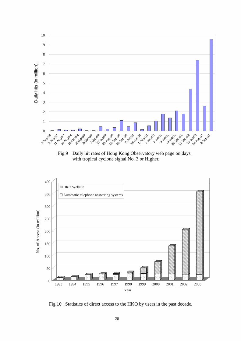
Protocol) and XML (eXtensible Markup Language) versions are available to satisfy the needs of diversified users ranging from those with visual impairment to those high-tech users with the latest generation of computing devices and mobile phones. The WAP site is gaining popularity and the access figures in 2003 was over 1 million, some four times that of 2002. There were over 330 million page visits to the HKO's website as a whole in 2003. Increasingly high hit rates have been recorded on days with approaching tropical cyclones as the internet-connected population grew (Fig. 9). Typhoon York brought more than a million hits on 16 September 1999 when it crossed Hong Kong. Typhoon Dujuan brought a record high of around 9.6 million hits on 2 September 2003. The HKO's website will be further enhanced by introducing the PDA version in April 2004. The public could then access weather information anywhere anytime.
The HKO greatly values this opportunity to deliver service directly to the
customers. We could now receive feedback from them and respond by adjusting our operations without going through any intermediaries. This is conducive to the continual improvement of our service in a way desired by the community we serve. Figure 10 shows the great increase in the number of direct access to the HKO by users during the past decade as a result of the Internet. The traditional fax, dedicated telephone links and automatic telephone answering systems are however retained as we could never ignore the majority especially the underprivileged who still have to rely on the phone or the basic radio.
The Dial-a-Weather service answers telephone calls from the public and
delivered taped recordings of weather information including tropical cyclone position and signal status. It handled 0.1 million calls in 1985 but grew rapidly, exceeding 20 million calls by 1995. Information is updated round the clock at hourly intervals or as new warnings are issued. The system is operated in Cantonese, English and Putonghua, reflecting the multi-lingual nature of the Hong Kong community. The Telephone Information Enquiry System (TIES), an interactive telephone answering system providing recording of local weather forecasts and weather information on other cities as well as fax-on-demand service of forecasts and weather maps, is another popular channel for the public to access weather information. In 2003, a total of around 780,000 calls were handled.
Close coordination with the media and collaboration with telecommunication service providers help cast a wide and efficient net for the dissemination of warnings. Hourly briefings by HKO professionals are broadcast on TV and radio during the passage of tropical cyclones and rainstorms. The public is given

12
up-to-date weather information while at the same time a caring and professional image is projected by HKO officers through the mass media.
Coordination with government departments and major private sector users
are enhanced through the use of dedicated web-based weather information servers. Some tailor-made products are made available to government users at dedicated webpages on the GOvernment Weather Information SErver (GOWISE) to facilitate their decision making in weather-related hazards. More specialised and tailor-made information is transmitted through this channel for the interpretation and consideration by the professionals and administrators. In addition, decision makers are also alerted to the issuance of warnings via emails. Unlisted telephone hotlines are reserved for key decision-makers to have direct consultations with HKO forecasters.
To further expand the dissemination net, HKO works with partners in the
private sector to display weather warnings on advertising boards in the streets, computer terminals at the airport and rail stations as well as electronic display boards on highways, etc. HKO also works closely with the local telecommunication service providers to deliver individualised alerts to customers. 7.3 Interpretation and decision-making process
The ultimate purpose of the warning services is to help the public incorporate
weather information into their decision making effectively. The diverse requirements from different sectors such as transportation and utility operators, aviation users, government departments, commercial companies, financial markets and tourists have to be met. At the one end, the warning system should be simple and easy-to-interpret, to serve as a trigger for the orderly response of the man in the street and that of the government. At the other end, comprehensive warning information has to be supplied to enable sophisticated individuals to decide on their own actions on the basis of cost-benefit analysis and risk assessment. 7.4 Review process
After individual severe weather events, the performance of the warning
services is reviewed to identify deficiencies as the basis to identify improvement measures. The Observatory started to use objective verification methods to calculate performance scores of weather forecasts in 1984. Objective verification results for 2003 indicated that 89.9 % of the forecasts were “acceptable”. Views and comments from the
13
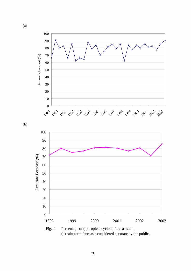
public are solicited through systematic public opinion surveys conducted regularly. The latest public opinion survey conducted in October 2003 showed that 80.2 % of the forecasts issued by the Observatory were perceived to be accurate by the public. This percentage is the highest since public opinion surveys were first introduced in 1989. The public's rating of the level of satisfaction with the overall services provided by the Observatory is 7.9 on a scale of 0 to 10. For the past couple of years, 90 % of tropical cyclone forecasts and 85 % of rainstorm forecasts were considered accurate by the public (Fig.11). Comments reported in the press are also collected and reviewed constantly.
Annual liaison meetings with government departments and key sectors to
review the services provided by HKO are arranged before the onset of the rainy season. The feedback from users contributes towards the continual improvement of the warning services. 7.5 Education process
The main theme of the education process is to raise the awareness of the
public and to promote their understanding of the meanings of warnings, characteristics of hazardous weather phenomena, forecast limitations and appropriate response actions. The objectives are achieved through a process of reaching out to the public.
The HKO set up the Friends of the Observatory in 1996 with a view to promoting the Observatory and its services to the public, and fostering communication between the Observatory and the public, so as to know more about the needs of the public. Talks and visits are arranged for the Friends of the Observatory and schools. Newsletters are published and distributed to the Friends of the Observatory, government departments and clients every four months. Every year in March, the Observatory organizes an Open Day to celebrate the World Meteorological Day. Typically, an exhibition is mounted to explain the work of the Observatory including weather forecasting. Visitors will have the opportunity to chat with Observatory staff to better understand the weather warning services and the challenge of weather forecasting.
Information pamphlets on warnings are published and distributed. Videos
and TV documentaries on weather are produced. Seasonal reminders are issued in the form of press briefings and press releases. Popular science lectures are organised to promote public interest in weather and climate. Educational materials such as topical web pages and press articles are posted on the HKO website. Basic courses on

14
meteorology are conducted for members of the public and government departments, with a view to strengthening their ability to interpret the radar and satellite imageries as well as weather charts posted on the HKO website.
The outreach activities has recently been strengthened, with colleagues
giving lectures to primary school students to foster their interest in weather. Visits to elderly people are also organised, to help them appreciate the meanings of the various warnings issued by the Observatory, especially the Cold Weather Warning and the Very Hot Weather Warning, so that they can take better care of themselves in inclement weather. 8. Overall Strategy and Looking Ahead
In operating the weather warning systems in Hong Kong, the HKO has in mind the wide spectrum of users, from the underprivileged who remains dependent on broadcasts on a simple radio to the high-tech, sophisticated individuals who follow closely the latest advances in telecommunication and computing devices. At one end of the spectrum, simple warning systems, such as the numbered Tropical Cyclone Warning System, serve to trigger the organized response of the government and that of the man in the street. The virtue is simplicity linked to a well-established behaviour pattern, which is conducive to an orderly response to approaching threat. At the other end, comprehensive information provided by HKO enables individuals to decide for themselves on actions to take to suit their own special circumstances. Thus, expressed in commercial parlance, HKO is marketing a diversity of products to serve a wide spectrum of niches, in the form of customers with different requirements and different degrees of sophistication. With the aid of the Internet and other emerging technology, the HKO will expand its identification of market niches and develop tailor-made services supported by science and commensurate with the needs of these niches. In summary, the overall strategies are diversity, aimed at serving users of different needs, and reaching out, which serves to impart knowledge to the public to enable them to understand weather warnings.
15
References Bell, G.J., 1981: 15 years of satellite meteorology in Hong Kong. Weather, Vol.36, No. 1, 9-15. Wong, S.K., and Ho, K.L. 1994: A brief history of the Royal Observatory weather radars. HKMetS Bulletin, Vol, 4, No. 2, 7-11. Lam, C.Y., 2000: Tropical Cyclone Warning System in Hong Kong. Presented at Regional Technical Conference on Tropical Cyclones and Storm Surges, Chiang Mai, Thailand, 13-17 November 2000. [Available online at http://www.weather.gov.hk/publica/pubreprint.htm.]
16
0
20
40
60
80
100
120
140
160
180
200
1960
1962
1964
1966
1968
1970
1972
1974
1976
1978
1980
1982
1984
1986
1988
1990
1992
1994
1996
1998
2000
2002
Year
No.
of p
erso
ns d
ead
or m
issin
g
Fig.1 Casualties caused by tropical cyclones in Hong Kong.
The built
environment
Expectations of
the Society
Warning System
Meteorological Science
Communication
Fig.2 Factors determining the form of a warning system.
17
Flimsy structures
Some loss of lives taken
for granted
Slow pace
Numbered signals
focus on wind
Little data
Visual signals
Fig.3 Tropical cyclone warning system in the early years.
better houses
Increasing value placed on life Faster pace
Textual information
Broadcasts Wind & track
Satellite Radar
Radio
TV
Fig.4 Tropical cyclone warning system, 1960’s to 1980’s.
18
Fig.5 Mean position errors of HKO subjective forecasts for
tropical cyclones over 10-30 N, 105 – 125 E.
Complex transport
infrastructure
“No loss of life”
Minimum disruption to
economic activities
Textual and graphic information on TC and local weather
Individualised alerting, Hhhomepage Wind, rain, track
NWP automatic weather stations
Telephone
Pager Mobile phone
Internet PDA
Fig.6 Tropical cyclone warning system, 1990’s- 2000’s.
19
Fig.7 History of severe weather warning systems in Hong Kong.
Fig.8 “Warnings with a heart” – a schematic diagram.
Warning Process
Review Process Development Process
Interpretation and Decision-making Process
Education Process
IMPACT NATURAL HAZARD
HUMAN SOCIETY
20
0
1
2
3
4
5
6
7
8
9
10
8-Sep-9
6
2-Aug-9
7
21-A
ug-97
10-A
ug-98
25-O
ct-98
30-A
pr-99
2-May-9
9
7-Jun
-99
27-Ju
l-99
23-A
ug-99
16-S
ep-99
26-S
ep-99
7-Oct-
99
18-Ju
n-00
1-Sep-0
0
7-Sep-0
0
2-Jul-
01
5-Jul-
01
25-Ju
l-01
20-S
ep-01
11-S
ep-02
23-Ju
l-03
24-A
ug-03
2-Sep-0
3
Dai
ly h
its (i
n m
illion
).
Fig.9 Daily hit rates of Hong Kong Observatory web page on days with tropical cyclone signal No. 3 or Higher.
���������������������������������������
����������������������
������
�������������������������� ���
�������������������������������������������������� ���
�������������������������������������������������� ���
��������������������������������
���������������
���������������������� ���
������������������������������
���������
����������������
����������������������
��������
���������������������������
����������������
������������������������
����������������������
��������
���������������������������
����������������������������
��������������������������������������������������������
�����������
��������
���������������������������
��������������������������������������������
��������������������������������������������������������������������������������
����������������������
������
��������������������������
���������������������������������������������������������
������������������������������������������������������������������������������������������������������������������������������������������������
��������������������
0
50
100
150
200
250
300
350
400
No.
of A
cces
s (in
mill
ion)
1993 1994 1995 1996 1997 1998 1999 2000 2001 2002 2003Year
��������HKO Website����
Automatic telephone answering systems
Fig.10 Statistics of direct access to the HKO by users in the past decade.
21
(a)
0
10
20
30
40
50
60
70
80
90
100
1989
1990
1991
1992
1993
1994
1995
1996
1997
1998
1999
2000
2001
2002
2003
Acc
urat
e Fo
reca
st (%
)
(b)
0
10
20
30
40
50
60
70
80
90
100
1998 1999 2000 2001 2002 2003
Acc
urat
e Fo
reca
st (%
)
Fig.11 Percentage of (a) tropical cyclone forecasts and
(b) rainstorm forecasts considered accurate by the public.