‘the way forward’ - tonbridge and malling · currently about 3,000 homes at kings hill. to...
TRANSCRIPT

Tonbridge & Malling
Borough Council
Local Plan
‘The Way
Forward’
Regulation 18
Issues and Options
September 2016


Foreword
We would like to thank you for taking part in this consultation on the new Local Plan for Tonbridge & Malling.
This consultation marks the first stage of plan-making. It is about identifying and sharing with you the issues the borough will face in the coming years and how we could, through positive planning policy, provide for the needs of our communities in a way that is responsible and sustainable.
There are many issues we need to consider including homes, jobs, community facilities and transport. We also need to recognise the importance of protecting valued natural and heritage assets and understand matters such as flood risk and biodiversity.
As this is the first stage of plan-making, this consultation focusses on strategic matters and we are keen to receive your views on the direction the Local Plan should take.
We hope that you take this opportunity to help us in preparing a new Local Plan for Tonbridge & Malling by responding to the questions posed in this document.
Cllr Nicolas Heslop Leader of the Council
Cllr Howard Rogers Cabinet Member for Strategic Planning and Infrastructure


i
A New Local Plan for Tonbridge and Malling - The Way Forward Explained
Introduction
Tonbridge and Malling Borough Council is preparing a new Local Plan. This is a very important document that will guide and manage future development in the Borough up to 2031.
The purpose of having a Plan is to identify future needs for new homes, jobs and community facilities such as schools, medical facilities, roads and public open space and then to put policies and plans in place to meet them. The Plan also provides a framework for considering and determining planning applications for anything from home improvements to major new developments.
Most people only become aware of Local Plans when they make a planning application themselves or if they have been consulted on an application nearby, but most Local Authorities have one and they have to be kept up to date. In areas where there are no Plans in place or existing Plans are becoming out of date Local Authorities and the communities they serve have less control over where and when development can take place.
Fortunately, Tonbridge and Malling is not in this position. We have an existing Plan adopted between 2007-10 and sufficient land supply to meet our needs for at least the next five years. Even so we must not be complacent. The Government wants Local Authorities to prepare their new Local Plans as soon as possible to take on board the planning reforms introduced over recent years. These reforms are mainly aimed at encouraging economic growth and ensuring a strong future supply of new homes. That is why we are pushing ahead with our timetable, which will see the new Plan adopted in 2019.
During this consultation we would like to invite you to become involved and share your views and comments on the emerging Plan. We will help you by guiding you through the process and by offering a number of different ways to respond to this consultation exercise.
Your comments will be carefully considered and taken into account as the Plan progresses. There will also be further consultations and opportunities for comment before the Plan is submitted to the Government next year.
This document summarises the progress we have made so far in compiling the evidence to support the Plan. It also sets out as simply as possible some of the national and local planning objectives that we are seeking to achieve. It then looks at a proposed way forward in the form of a potential development strategy.

ii
More detailed policies will follow in future drafts of the Plan while at this stage we are setting out the main issues for the Plan to address and establish a high level approach that will form the basis for the rest of the Local Plan.
This note will conclude by providing links to further information and full versions of the consultation documents as well as a summary of how to get involved.
A New Local Plan for Tonbridge and Malling – Progress So Far
In order to plan for future development we have to understand what future needs will be and this has been the focus of the work so far. One of the most fundamental needs is for homes and for this reason one of the first pieces of evidence prepared was something called a Strategic Housing Market Assessment or SHMA.
Using an approach prescribed by Government, the SHMA estimates the need for new housing up to 2031 based on population changes, how households change and how people move home into and out of the Borough. It also looks at ‘hidden households’, where people are not able to get the homes they need usually because of the affordability of the housing that is available.
The SHMA also considers where the needs should be met in the Borough depending on where the need arises, the type and tenure of housing (from flats to family homes, homes for older people and those buying their first home, for ownership or renting). Importantly, it also considers the affordability of new housing.
The SHMA will continue to be reviewed regularly to ensure it is up to date. In the summer of 2016 based on the prescribed approach our need was for 13,920 new homes over the 20 year Local Plan period or 696 a year. However, once existing planning permissions and known sites are taken into consideration, we need to find land for approximately 6,000 additional homes. To put that into context, there are currently about 3,000 homes at Kings Hill.
To begin the process of finding sites where this future growth could be located we have also invited suggestions through a ‘call for sites’ during which we received over 250 submissions across the Borough. These have been assessed for their practical potential to deliver future growth by 2031. This exercise forms part of our Strategic Land Availability Assessment (or SLAA) which is an important part of our evidence but does not mean that the sites coming through will end up being allocated for development. We do believe though, that the evidence shows that we should be able to provide for our future housing needs. Other parts of the evidence base have considered our future needs for employment land and jobs. Like the housing assessments, this has been broken down into what type of employment land and

iii
jobs are needed and where it should be located. The evidence shows that we need to find up to a further 33 hectares of employment land up to 2031 or the equivalent of about 20 football pitches.
This Local Plan will consider the best way to meet our future development needs and also deliver some of our other planning objectives, such as improving community facilities and protecting the best of our local environment, heritage assets and amenities. The consultation document ‘The Way Forward’ explains how we propose to do this and we would really appreciate your views, particularly in respect of the suggested development strategy.
Once the development strategy starts to take shape the rest of the Local Plan can be worked up, such as deciding where new schools and GP surgeries will be located, how and when improvements to the road network and other forms of transport will be introduced and the preparation of more detailed planning policies to supplement the national planning framework. We will also seek your views on these next year.
The Way Forward – A Proposed Development Strategy for the Local Plan
The Way Forward document explains in more detail why we are preparing this Plan, what it has to address and the thinking that leads to a proposed strategy. Questions are posed throughout the document and there are a number of ways that you can respond, which will be explained at the end of this note.
To meet the needs we have identified we start by looking at the sites and the opportunities that the Government and our own residents would expect us to prioritise, for example, any sites that have been previously developed (also known as ‘brownfield’ sites) and other sites located within built up areas that are at the least risk from flooding. There are also sites in the current Plan that have been previously identified as having potential for meeting future needs, safeguarded sites and opportunity areas. We have called these the building blocks for the strategy. They are the obvious starting point, but they alone will only meet about a third of our needs.
To meet the remainder we have applied a number of guiding principles based on national and local planning policy objectives. These include meeting needs where they arise across the two housing market areas and making the most of existing infrastructure by locating development around transport hubs, for example in locations close to railway stations and bus routes.
It is also important to ensure that there is a range of sites, both large and small, so that the benefits of new growth can sustain local services and businesses in some of

iv
our smaller settlements while also delivering a higher volume of new homes through larger developments to sustain our 5 year housing land supply which we are required to make available.
Some of those larger sites may also provide opportunities to deliver much needed, strategic infrastructure improvements, such as relief roads or new schools, the funding for which from more traditional sources is falling. However, such sites should be of a proportionate size capable of delivering the infrastructure to meet the needs of the new community.
The potential development strategy contained in the Way Forward is derived from tackling the issues arising from the evidence described earlier and working with these building blocks and guiding principles to suggest a quantum and distribution of future development that best meets our future needs while delivering on a number of national and local planning objectives in the most sustainable way.
We would welcome your views on the Way Forward whether you think we have got it about right or whether you think there might be an alternative way. Further information on how to get involved can be found below.
How to Get Involved in the Local Plan and Have Your Say on the ‘Way Forward’
The first public consultations on the new Local Plan for Tonbridge and Malling will commence on Friday 30th September 2016 and run for 8 weeks closing at 5pm on the 25th November.
There will be copies of everything you need on our website, but if you would prefer to see a hard copy of the consultation documents they will be placed at the Borough Council’s main offices at Kings Hill and Tonbridge Castle, and in all libraries in the Borough. Copies will also be provided to each of the 27 Parish and Town Councils in Tonbridge and Malling.
There are 15 questions in the consultation document, to which we would welcome your responses either in writing, by email or by filling out a survey on-line. Alternatively you may wish to make your own comments, which again, we would welcome either in writing or by email (see addresses at the foot of this note).
There will be some small public exhibitions around the Borough for set periods during the 8 week consultation and these will be manned at certain times if you would prefer to talk to one of us about the Local Plan. Details can be found on our website.

v
To find out more about the Local Plan, the evidence base and see the full consultation documents and how to respond please visit our web-site here:
https://www.tmbc.gov.uk/services/planning-and-development/planning/planning-local-plans
Our address is: Tonbridge and Malling Borough Council, Local Plans Team, Gibson Building, Gibson Drive, Kings Hill, West Malling, ME19 4LZ
Our email address is: [email protected]
If you would like to be kept up to date with progress on the Local Plan and/or be contacted as part of future consultations you may wish to be included on our Local Plan mailing list? If so please send us your name and address and/or email address.
We look forward to hearing from you.

vi

Table of Contents
1. INTRODUCTION 1 1.1. What is the role of the Local Plan? 1 1.2. Why is it important to be involved with the making of a new Plan? 1 1.3. What is this consultation exercise aiming to achieve? 1
2. CONTEXT 3 2.1. Why is there a need to prepare a new Plan now? 3 2.2. What are the expectations of the Government? 3 2.3. Why is the Government keen to meet needs and boost significantly the supply of housing? 4 2.4. What are the risks of not preparing a new Plan or preparing a new Plan that does not respond to the Government’s objectives? 4 2.5. What are the benefits of preparing a new Plan that responds to the Government’s objectives? 5
3. PLAN-MAKING PROCESS 7 3.1. How will the new Local Plan be prepared? 7 3.2. How will the Plan be assessed? 8
4. LOCAL PLAN ISSUES AND OBJECTIVES 9 4.1. How were the issues identified? 9 4.2. What broad issues does the existing evidence identify? 9 4.3. What key issues has the evidence identified? 16 4.4. What the Local Plan cannot address 16 4.5. Which key objectives does the Plan need to address? 17
5. LOCAL PLAN – STRATEGY CONSIDERATIONS 19 5.1. Introduction 19 5.2. What are the building blocks for the Local Plan strategy? 19 5.3. How can the building block opportunities be assessed? 19 5.4. How is the potential contribution of each building block assessed? 20 5.5. How do the building blocks perform in the assessment? 21 5.6. Which principles should guide the development strategy for the new Local Plan? 21 5.7. What do we need to consider when applying the guiding principles to the formulation of a development strategy for the Local Plan? 23 5.8. How can we find a proportionate policy response? 24 5.9. What could a sustainable development strategy for the new Local Plan look like? 25
6. LOCAL PLAN – OTHER KEY STRATEGIC CONSIDERATIONS 35 6.1. How should the new Local Plan respond to the economic evidence? 35 6.2. What should be the future role of Tonbridge Town Centre? 36 6.3. What should the Green Belt boundaries be in the Local Plan? 37
7. LOCAL PLAN – MANAGING DEVELOPMENT 41 7.1. In delivering sustainable growth, what issues are important to you? 41 7.2. How should the Local Plan respond to the optional National Standards? 42
8. LOCAL PLAN – PARTICIPATION 45 8.1. How can you participate in this consultation? 45
Appendix A: Glossary of Terms 51 Appendix B: Key Constraints 55 Appendix C: Building Blocks Assessment Pro-forma 57 Appendix D: Building Blocks (A, B and C) Pro-formas 59 Appendix E: Combined Building Blocks (A, B and C) Map and Pro-forma assessment 63 Appendix F: Potential Development Strategy 65


Local Plan – The Way Forward
1
Tonbridge & Malling Borough Local Plan
The Way Forward
An invitation to have your say in shaping the future of where you live
1. Introduction
What is the role of the Local Plan? 1.1.
The Local Plan should set out a vision and a framework for the future 1.1.1.sustainable growth of the borough, addressing needs and opportunities for housing, the economy, community facilities and infrastructure as well as safeguarding natural and heritage assets and securing good design.
Why is it important to be involved with the making of a new 1.2.Plan?
Your involvement will help the overall understanding of local priorities, 1.2.1.opportunities for sustainable growth and constraints to future development.
This consultation is an opportunity to shape policies that, once adopted, will 1.2.2.represent the starting point for decision-taking on development proposals for the next 10-15 years.
What is this consultation exercise aiming to achieve? 1.3.
To have a clear direction the Plan needs to take account of local views in 1.3.1.responding positively to meeting the needs of communities. It is important that we encourage constructive thoughts and support about how we can plan in this way.

Local Plan – The Way Forward
2

Local Plan – The Way Forward
3
2. Context
Why is there a need to prepare a new Plan now? 2.1.
The Borough Council’s existing Development Plan Documents are now a 2.1.1.little dated; there is a need to respond to the National Planning Policy Framework and importantly to reflect current local evidence including objectively assessed needs for homes, land availability, flooding and employment.
What are the expectations of the Government? 2.2.
The Government’s objectives are set out in the National Planning Policy 2.2.1.Framework (NPPF). The NPPF places Local Plans at the heart of the planning system, so it is essential that they are in prepared and kept up-to-date. It makes it clear that local authorities should:
• positively seek opportunities to meet the development needs of their area (para.14)
• boost significantly the supply of housing (para.47) • follow the approach of the presumption in favour of sustainable
development so that it is clear that development which is sustainable can be approved without delay (para.15)
• deliver a sound plan which is positively prepared in terms of seeking to meet objectively assessed needs; is justified by the evidence; is deliverable; and consistent with national policy, (para. 182)
• work with neighbouring authorities to ensure that strategic priorities across local boundaries are properly coordinated and clearly reflected in individual Local Plans (para.179).
• have regard to conserving biodiversity as part of policy and decision
making. This is known as the Biodiversity Duty.

Local Plan – The Way Forward
4
Why is the Government keen to meet needs and boost 2.3.significantly the supply of housing?
The supply of housing across the country, particularly in the South-East, is 2.3.1.not keeping up with need. This mismatch has meant that affordability has become an acute problem.
Figure 1: Earnings compared with house prices in Tonbridge & Malling (2014)
Source: Strategic Housing Market Assessment (Figures 26 & 31) (June 2015)
In Tonbridge & Malling, mid-point house prices (overall) are over 8 times 2.3.2.greater than mid-point earnings.
This means that there are many households in Tonbridge & Malling that are 2.3.3.unable to access the housing market. Adding to the supply of homes of varying types, sizes and tenures will help address this. The Local Plan should take a constructive and positive stance towards meeting identifiable needs for new homes which will inevitably mean some challenging decisions in some parts of the borough.
What are the risks of not preparing a new Plan or preparing a 2.4.new Plan that does not respond to the Government’s objectives?
There are three significant risks: 2.4.1.
• Uncertainty – The absence of a plan means that there would be no confidence over where development may or may not happen over the next 10-15 years. It could also stifle labour supply and economic growth.
29,706
250,000
0
50,000
100,000
150,000
200,000
250,000
300,000
Mid-pointEarnings
Mid-pointHouse Price

Local Plan – The Way Forward
5
• Planning by Appeal – In the absence of an up to date plan planning
decisions may be subject to challenge by appeal meaning that decisions on proposals will increasingly be made by an independent Inspector with no local connection rather than through local decision-making
• Government intervention - If the Borough Council does not move forward with plan-making, there is the risk that the Government will intervene and force a local plan to be prepared for the borough.
All of these risks have one thing in common; reduced local influence over 2.4.2.what happens in the borough.
What are the benefits of preparing a new Plan that responds 2.5.to the Government’s objectives?
A sound plan, shaped by local people, provides certainty, and therefore 2.5.1.confidence, in many ways:
• Clarity over where sustainable growth should take place.
• Certainty over the level of growth needed to deliver improvements in infrastructure to benefit existing and new communities.
• Supports economic growth.
• Clarity over which important natural and heritage assets can be protected from development.
• Ensuring that the basis for decision-making on proposals is clear and has been shaped by local evidence and local communities through on-going engagement.

Local Plan – The Way Forward
6

Local Plan – The Way Forward
7
3. Plan-making process
How will the new Local Plan be prepared? 3.1.
The starting point in the process is gathering evidence about key matters 3.1.1.that will influence future development. The Council has collated, and continues to update, evidence covering matters including, population housing, jobs and flooding, as set out below. This has been shaped by the expectations of the Government. This evidence is explained in more detail in Section 4.
• Strategic Housing Market Assessment
• Strategic Land Availability Assessment
• Housing Land Supply Position
• Economic Futures Forecasting
• Employment Land Review
• A20 Corridor Study
• Gypsy and Traveller Accommodation Assessment
• Strategic Flood Risk Assessment
• Kent Habitats Survey
• Green Belt Study
• Plan Viability
This consultation is the next stage and introduces the issues the new Plan 3.1.2.will need to tackle, together with the potential responses available to positively respond to them.
The Borough Council will carefully consider responses received during the 3.1.3.initial consultation. This will inform the next stage in the plan-making process.
The full timetable can be found here: www.tmbc.gov.uk/localplan 3.1.4.

Local Plan – The Way Forward
8
How will the Plan be assessed? 3.2.
The environmental, economic and social credentials of the development 3.2.1.options and policies in the emerging Local Plan will be subject to a Sustainability Appraisal (SA). The Sustainability Appraisal plays an important role in demonstrating that the Local Plan reflects sustainability objectives and has considered all reasonable alternatives. It incorporates the requirements of the Strategic Environmental Assessment (SEA) Directive.
The Local Plan will also be subject to a Habitats Regulations Assessment 3.2.2.(HRA) undertaken in accordance with the Habitats Directive.
Both the Sustainability Appraisal, incorporating the requirements of the 3.2.3.Strategic Environmental Assessment, and the Habitats Regulations Assessment will be published alongside this document for consultation.

Local Plan – The Way Forward
9
4. Local Plan issues and objectives
How were the issues identified? 4.1.
The Government’s policy is very clear that ‘…every effort should be made 4.1.1.objectively to identify and then meet the housing, business and other development needs of an area…’ (NPPF, para.17, core principle 3). In response to this requirement the Council undertook evidence gathering for various issues including housing, employment and environmental matters. Set out below are the headlines from each piece of work. Further details, including the evidence itself, are available from the Local Plan web page: www.tmbc.gov.uk/localplan.
What broad issues does the existing evidence identify? 4.2.
Housing
The Strategic Housing Market Assessment (SHMA) provides an 4.2.1.understanding of housing market dynamics, an assessment of future housing needs for both market and affordable housing and the housing requirements of different groups within the population. The Strategic Housing Market Assessment concluded that there are, broadly speaking, two Housing Market Areas (HMAs) exerting an influence across the borough:
• Maidstone & Malling • Sevenoaks/Tunbridge Wells/Tonbridge
A housing market area is a geographical area defined by household demand 4.2.2.and preferences for all types of housing, reflecting the key functional linkages between places where people live and work. To determine the geographical extent of HMAs, data including house prices, migration flows and travel to work areas is analysed.
Figure 2 illustrates the extent of the influence of each of these HMAs across 4.2.3.the borough. An appreciation of this pattern of HMAs is important for understanding how far we can meet needs where they are generated and achieve sustainable patterns of development.

Local Plan – The Way Forward
10
Figure 2: Influence of different Housing Market Areas on Tonbridge & Malling Borough
The Strategic Housing Market Assessment (SHMA) has identified an 4.2.4.Objectively Assessed Need (OAN) of 696 homes per annum for the period 2011-2031. This is a demographic-based projection that has been subject to local sensitivity testing as required by the Government’s Planning Practice Guidance.
The figure of 696 homes per annum is the gross need for the borough; 4.2.5.completions and outstanding commitments since the base date (2011) need to be subtracted, to work out the net need that the new Local Plan needs to address. As a result of positive planning by the Borough Council a significant amount of homes have been built since 2011 (2,845 units) and there are many units in the pipeline that already have planning permission (4,244 units as at 31st March 2016). In addition there are 104 units from unimplemented allocations in the existing Development Plan. Taking account of a modest

Local Plan – The Way Forward
11
windfall projection from small sites (fewer than five units in capacity) of 44 units per annum1, this translates to a net need that the Plan must respond to of approximately 6,000 units (400 units per annum, 2016-2031).
In addition the SHMA identified an affordable housing need of 277 homes 4.2.6.per annum and a registered care need (C2 use class) of 20 bed spaces per annum for the plan period (2011-2031). The need to address affordable housing provision is particularly important in Tonbridge and Malling. Our evidence shows this and whilst there is has been a relatively strong supply in the recent past, changes to national policy and funding to Registered Housing Providers is making this task more challenging. We will need to set a policy with an intention to maintain the supply of affordable housing within that context. Inevitably that will mean different types of affordable homes, such as more starter homes, but we must also strive to seek more traditional forms of social rented accommodation.
Local evidence has concluded that there is a net need of 21 pitches (2012-4.2.7.2028) for Gypsy and Traveller accommodation. Analysis of data has shown a need for 2 plots for Travelling Showpeople over the assessment period.
Historic Housing Land Supply: Since the base date of the adopted 4.2.8.Development Plan (2006/07), cumulative housing completions have consistently exceeded the cumulative requirements as illustrated in Figure 3 (below). This demonstrates that the Borough Council has a sound record of delivery, according to the criteria set out in the Government’s Planning Practice Guidance.
Figure 3: Housing Trajectory
4.2.9. This is a result of positive planning for significant opportunities that have arisen in the past including at Peter’s Village, Kings Hill, Leybourne Chase
1 Discounted (by 50%) of average supply from small site windfalls over the last five years (2011/12-2015/16) (excluding back gardens)

Local Plan – The Way Forward
12
and Holborough Lakes. The expectations of the Government are that this positive planning approach needs to continue. However, due to a long history of making the most of brownfield land to meet needs, the opportunities for locating new development on brownfield land are becoming few and far between. This presents challenges for the new Local Plan, to broadly maintain historical levels of development without the brownfield land resource to assist. In other words, significant areas of fresh land will need to be identified.
4.2.10. Projected Five-Year Housing Supply:. As a result of positive local planning the Borough Council can demonstrate 5.3 years’ worth of land supply as measured against the Objectively Assessed Need from the SHMA of 696 units per annum (+ 5% - see Table 1 below). This means that the relevant policies in the Borough Council’s adopted Development Plan on supply are still current and not out-of-date, according to the requirements of para.49 in the NPPF. But that is no reason for complacency. Rather it is a demonstration that forward looking planning provides the best way of managing the future of development in the borough.
Table 1: Housing Land Supply Position as at 31st March 2016
Year Sites with
Permission (1)
Small Sites Estimate
Large Sites Windfalls
Allocations (2)
Kings Hill Phase 3
Kings Hill (3)
Holborough Quarry (4)
Leybourne Grange
Peters Pit
Tonbridge Central Area completions
and permissions
Completions 5 Year Totals Total Supply 2006-2021
5 Year Supply
2016/17-2020/21
2006/07 437 281 85 47 8502007/08 349 300 137 53 8392008/09 280 224 91 203 798 32102009/10 209 93 47 16 7 3722010/11 145 55 18 59 74 3512011/12 119 90 100 22 113 4442012/13 151 84 59 70 30 3942013/14 257 108 12 82 149 608 28452014/15 267 91 43 26 60 4872015/16 441 74 64 14 319 912 99072016/17 361 44 5 53 82 95 50 198 8882017/18 458 44 25 50 0 80 118 100 30 9052018/19 463 44 33 100 0 80 100 152 77 1049 3852 38522019/20 35 44 20 100 0 80 95 150 4 5282020/21 6 44 21 100 48 80 33 150 4822021/22 0 44 100 62 150 3562022/23 6 44 100 150 3002023/24 44 85 98 227 9712024/25 44 442025/26 44 44Totals 3984 440 0 104 635 1501 1120 730 1000 1364 10878
5-Year Supply (6)
No. of years of HLS (7)
Note (1) Excluding Strategic Sites & Tonbridge Town CentreNote (2) Includes 65 dwellings on allocated land at Kings Hill. 21 units phased in 2020/21 are on an allocation where the planning permission has expired.Note (3) Excludes 65 dwellings on allocated land without permissionNote (4) Holborough Quarry 2008/09 error - should have been 91 units not 182 unitsNote (5) Objectively Assessed Need (OAN) for housing identified in the Strategic Housing Market Assessment (SHMA) (Update, September 2016) plus 5% buffer as required by para. 47 in the NPPFNote (6) Supply of ready to develop housing sites as a % of the 5-year OAN requirement (see footnote (5))Note (7) Number of years of Housing Land Supply (HLS) measured against 5-year OAN requirement + 5% (see footnote (5))
Next 5 years of projected housing supply 5-year supply as a percentage of the OAN requirement (see footnote (5)) Post Plan Period (2006-2021) Number of years of housing land supply measured against 5-year SHMA requirement (see footnote (5))
5.3
SHMA 5 yr OAN +5% (5) 3654Difference 198
105%

Local Plan – The Way Forward
13
Employment
The Employment Land Review concluded that there is just enough supply, in 4.2.11.quantitative terms, to meet office needs but there is a shortfall of industrial space of up to 33 ha. It is for the Local Plan to consider positive strategies for addressing this for the benefit of local people.
The Employment Land Review also concluded that given that much of the 4.2.12.Borough is rural in nature, it is important that planning policy supports sustainable rural based employment development and responds positively to proposals that encourage the reuse of redundant agricultural buildings to meet future industrial and office based needs. The current roll-out of fibre broadband across Kent (which will extend coverage to significant parts of Tonbridge & Malling’s rural areas) will help to overcome some key infrastructure and accessibility barriers typically faced by rural businesses and provide the opportunity for the Borough’s rural locations to play a greater economic role in future.
Strategic Flood Risk
The Level 1 Strategic Flood Risk Assessment (SFRA) (August 2016) 4.2.13.recommends a risk-based and sequential approach to development and flood risk, so that development is located in low flood risk areas where possible; it is recommended that this approach is adopted for future developments within the borough. The SFRA recommends that development must seek opportunities to reduce overall levels of flood risk at sites, for example by: reducing volume and rate of surface water runoff; locating development to areas with lower flood risk; creating space for flooding; and/or integrating green infrastructure into mitigation measures for surface water runoff from potential development. It includes an assessment of the potential increase in flood risk due to climate change.
Green Belt
An assessment of the robustness of the existing boundaries of the Green 4.2.14.Belt, as measured against the purposes identified in the Government’s NPPF, has been prepared in parallel with considering where the main areas of potential for new development might be. The objective is to ensure that, at the end of this exercise, the boundaries are robust and can endure at least for the duration of the plan period (up to 2031).

Local Plan – The Way Forward
14
Kent Habitats and the Natural Environment
Tonbridge and Malling is home to a variety of internationally, nationally and 4.2.15.locally important wildlife sites, as well as two Areas of Outstanding Natural Beauty (AONB); the Kent Downs AONB to the north, and the High Weald AONB to the south.
The Kent Habitats Survey (2012) identifies that Tonbridge & Malling borough 4.2.16.extends over four National Character Areas (NCAs), which contribute to the wide variety of habitats found within the area. Six Biodiversity Opportunity Areas (BOAs) have been identified across the borough and these include a range of UK Biodiversity Action Plan (BAP) Priority Habitats, some of which contribute significantly to Kent’s overall resource.
Approximately 11% of the borough (2,621ha) is covered by Ancient 4.2.17.Woodland (Ancient Woodland Survey 2010).
Infrastructure
As part of the assessment of the Call for Sites submissions, key 4.2.18.infrastructure providers were engaged with to help with the assessment of suitability and the likely requirements for supporting infrastructure such as schools, healthcare and highways. The assessment of potential development options for the new Local Plan will need to take into account the land-take required for new community facilities and infrastructure. Equally, it is important that we positively plan for a level of sustainable growth that can facilitate significant improvement to infrastructure taking into account the capacity and pressure on existing community facilities and infrastructure and the requirements generated by households within new communities. It will be important for the sites that eventually emerge as Local Plan allocations have the provision of appropriate community facilities and Infrastructure as an integral part of the allocation process to ensure the best opportunities for delivery...
A study to establish the baseline data for the A20 between Ashton Way and 4.2.19.the Coldharbour roundabout was completed in May 2016. The study clarifies and confirms existing capacity issues along the corridor and identifies some minor improvements to junctions and traffic management measures. It also prepares the way for further modelling work that will ‘test’ the acceptability of potential new development allocations and importantly provide the justification for more significant improvements that could be delivered through the Local Plan.

Local Plan – The Way Forward
15
Strategic Land Availability Assessment (SLAA)
This piece of evidence identifies those sites that were brought forward as 4.2.20.part of the ‘Call for Sites’ exercise as being potentially suitable and deliverable for development.
This assessment is a technical exercise in accordance with National 4.2.21.Guidance, primarily to clarify practical aspects of the sites, rather than to judge whether or not they should feature as future allocations for development in the Local Plan. This means that the assessment did not take account of local policy considerations, including the extent of Green Belt boundaries, which are matters for consideration during the making of the Local Plan itself.
Based upon an average yield of 30 dwellings per hectare, the SLAA 4.2.22.concluded that those sites assessed as suitable and deliverable have an overall capacity of approximately 26,000 homes. The outcome of this calculation is by no means a final figure or indeed any indication of what is acceptable in planning terms; if and when the sites are progressed through to this plan-making stage a more detailed assessment will be required, see later in this report. At that stage planning judgements about how much, if any, of a site is appropriate for development will need to be made which might well reduce the area and yield significantly. Again, at that stage it will be necessary to understand fully the land-take for supporting uses including schools, healthcare facilities, playing fields, amenity space and roads. Potential yield at this stage is therefore very much a starting point for this exercise.
Viability
‘Whole plan viability’ will need to be assessed in accordance with 4.2.23.government guidelines that seek to ensure that sites will come forward and not be stalled by financial burdens. The assessment needs to demonstrate that the sites and scale of development are viable, taking into account the need for infrastructure provision and the effect of other policies regarding development standards and, importantly affordable housing provision. The opportunity to undertake this assessment is when we have a clear development strategy and detailed policies.

Local Plan – The Way Forward
16
What key issues has the evidence identified? 4.3.
The evidence highlighted above has identified the following key issues: 4.3.1.
• Objectively Assessed Need (OAN) for housing of 696 units per annum (2011-2031)
• Affordable housing need of 277 units per annum (2011-2031) • Registered care need (C2 use class) of 20 bed spaces per annum (2011-
2031) • Good long-term record of housing delivery • 5.3 years’ worth of housing land supply, see Table 1 • Shortfall of up to 33 ha of industrial space • A range of UK Biodiversity Action Plan (BAP) Priority Habitats, some of
which contribute significantly to Kent’s overall resource. • A significant number of potential sites providing choice for future
development.
What the Local Plan cannot address 4.4.
In addition to considering what the Plan needs to cover, it is equally 4.4.1.important to understand what the Plan cannot include. The Government’s Planning Practice Guidance makes it very clear what Local Plans should exclude:
‘…In drafting policies the local planning authority should avoid undue repetition, for example by using generic policies to set out principles that may be common to different types of development…’. (Paragraph: 010 Reference ID: 12-010-20140306)
‘…There should be no need to reiterate policies that are already set out in the National Planning Policy Framework…’. (Paragraph: 010 Reference ID: 12-010-20140306)
Where it is not supported by evidence to add anything locally-distinctive to 4.4.2.the national policy objective(s), the Local Plan will sign-post the reader to the relevant policy in the NPPF or current Government policy at the time the plan is published. Examples of such National policies include those relating to natural and historic assets, for example: Conservation Areas, Listed Buildings, and Sites of Special Scientific Interest. In addition, the purposes and policy objectives of the Green Belt will not be replicated, although the existing boundaries will be assessed as part of the plan-making process as expected by the Government in the NPPF.

Local Plan – The Way Forward
17
Which key objectives does the Plan need to address? 4.5.
The local evidence, Government policy and initiatives promoting the most of 4.5.1.brownfield land and transport hubs, point to the following set of objectives that the Local Plan should aim to achieve:
Plan Objective 1: As far as possible to provide for homes and jobs that are best suited to meet identified local needs.
Plan Objective 2: Support and sustain local communities across the borough, big and small, by planning to meet identified needs, including needs for community facilities.
Plan Objective 3: Protect high value, important natural and heritage assets.
Plan Objective 4: Deliver sustainable growth to support urban and rural economies, making the best use of infrastructure.
Q1. Do you agree or disagree with this set of objectives for the new Local Plan?
Please explain.

Local Plan – The Way Forward
18
Local Plan – The Way Forward
19
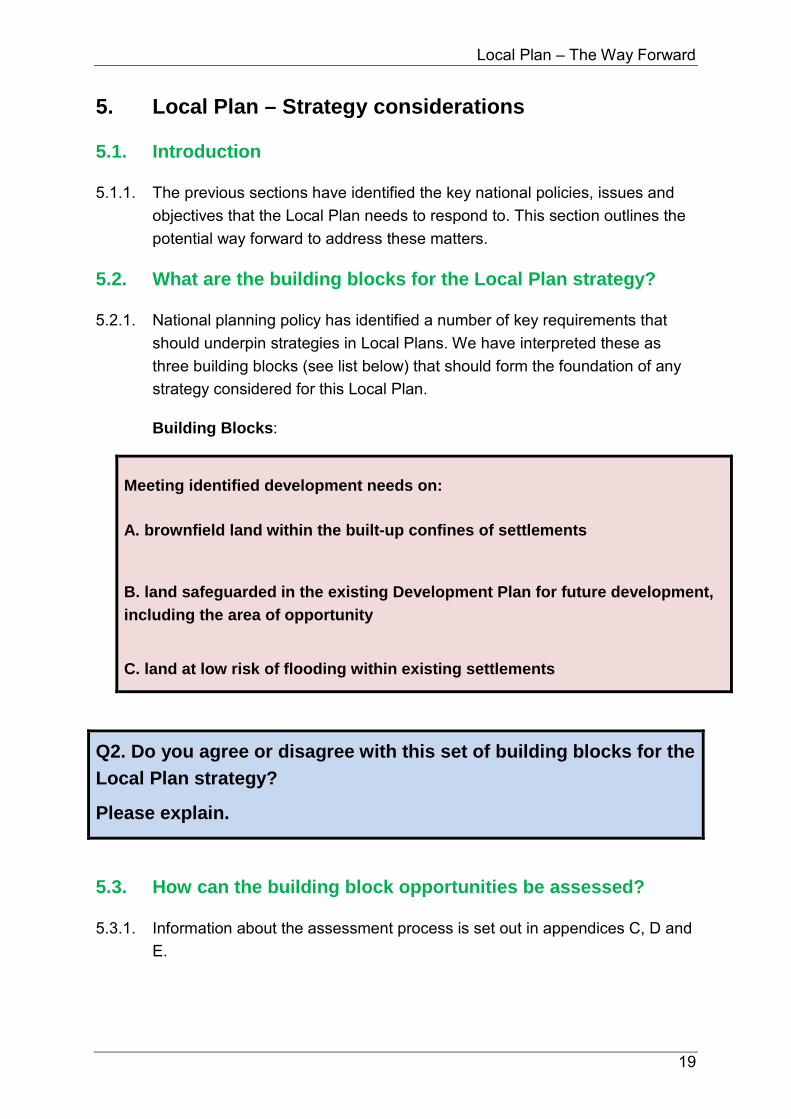
5. Local Plan – Strategy considerations
Introduction 5.1.
The previous sections have identified the key national policies, issues and 5.1.1.objectives that the Local Plan needs to respond to. This section outlines the potential way forward to address these matters.
What are the building blocks for the Local Plan strategy? 5.2.
National planning policy has identified a number of key requirements that 5.2.1.should underpin strategies in Local Plans. We have interpreted these as three building blocks (see list below) that should form the foundation of any strategy considered for this Local Plan.
Building Blocks:
Meeting identified development needs on: A. brownfield land within the built-up confines of settlements
B. land safeguarded in the existing Development Plan for future development, including the area of opportunity
C. land at low risk of flooding within existing settlements
Q2. Do you agree or disagree with this set of building blocks for the Local Plan strategy?
Please explain.
How can the building block opportunities be assessed? 5.3.
Information about the assessment process is set out in appendices C, D and 5.3.1.E.

Local Plan – The Way Forward
20
This assessment asked key questions including: 5.3.2.
• Does this make a positive contribution to addressing assessed needs? • Which plan objectives does this respond to? • Would this achieve a sustainable pattern of development?
How is the potential contribution of each building block 5.4.assessed?
The starting point is the assessment of the Call for Sites submissions. This 5.4.1.was a technical assessment that took account of high-level constraints beyond the control of the Borough Council but which precluded development, for example, in Special Areas of Conservation, and areas at high risk of flooding.
Now that we are at the plan-making stage, consideration needs to be given 5.4.2.to designations which will have more bearing on what could be realistically achieved. These include: Air Quality Management Areas; Conservation Areas; Listed Buildings; Historic Parks & Gardens, Areas of Outstanding Natural Beauty; Grade 1 Agricultural Land; Local Wildlife Sites and Priority Habitat Areas.
In assessing the development potential of sites, these designations are 5.4.3.discounted from the developable area. In some cases this results in suitable and deliverable sites being eliminated altogether.
In respect of the Green Belt, the Government’s National Planning Policy 5.4.4.Framework is very clear that the preparation of the Local Plan is the time to review the boundaries of the Green Belt (para.83). With this in mind, land that currently falls within the Green Belt is not discounted, in the first instance, but instead the risks posed to the Green Belt are highlighted.
The outcome of this process is an area which is then multiplied by 30 5.4.5.(average density of housing units per hectare) to understand the broad development potential.
Please Note: This development potential should be treated with caution because it is inevitable that there will be land-take for necessary supporting infrastructure, for example roads and amenity space. For the larger sites, the land-take for supporting infrastructure is likely to be more significant because of the need for facilities including education, healthcare and local centres. This is something that will be revisited and worked-up in more detail in consultation with key infrastructure

Local Plan – The Way Forward
21
providers once we have a clearer direction for the new Local Plan.
How do the building blocks perform in the assessment? 5.5.
It is evident from the assessments that the building blocks would not produce 5.5.1.enough potential to form a sound approach to housing affordability and labour supply to support the local economy. It is also evident from the assessments that, individually, the building blocks would not adequately address the draft Plan Objectives. It is also the case that whilst making a significant contribution, the combination of all three building blocks would also not address the full set of Plan Objectives.
Table 2: Cumulative contribution of the building blocks
Building Block Description Potential Yield
A Meeting identified development needs on brownfield land within the built-up confines of settlements
267
B
Meeting identified development needs on land safeguarded in the existing Development Plan for future development, including the area of opportunity
2,087
C Meeting identified development needs on land at low risk of flooding within existing settlements
276
Total Potential Yield 2,363*
*excluding double-counting where there is overlap between the building blocks
Although the potential development arising from the application of these 5.5.2.building blocks alone would fall significantly short of the identified need for development, they are sound components that should form the foundation of whatever strategy ultimately underpins the new Local Plan.
Which principles should guide the development strategy for 5.6.the new Local Plan?
The outcome of the assessment of the building blocks means that in order to 5.6.1.effectively respond to Government policy, local evidence and the draft plan objectives, we need to consider opportunities beyond existing settlement confines.

Local Plan – The Way Forward
22
To help guide decision-making on which opportunities should be considered 5.6.2.in more detail, a set of principles have been prepared.
The principles identified to guide decisions about the location of future development are as follows:
1. Focussing opportunities adjacent to the principal urban areas of the
Medway Gap and Tonbridge, in each housing market area
2. Focussing opportunities adjacent to a range of settlements across the borough to help support and sustain local communities, big and small
3. Locating new development in reasonable proximity to transport hubs, utilising and building upon existing infrastructure
4. Locating new development in the least constrained parts of the borough
5. To provide a mixed portfolio and location of sites, big and small, to meet a range of needs throughout the duration of the plan period up to 2031, over the short-term (up to 5 years), medium-term (6-10 years) and over the long-term (11-15 years)
6. To deliver a level of growth at key locations to facilitate significant improvements to support infrastructure, eg schools, highways and healthcare, for the benefit of local communities
7. Focussing development on the contribution that larger potential sites could deliver in a proportionate way to meet wider plan objectives and ensure delivery in the plan period.
Please Note: These principles should not be read in isolation.
Q3. Do you agree or disagree with this set of guiding principles?
Please explain.

Local Plan – The Way Forward
23
What do we need to consider when applying the guiding 5.7.principles to the formulation of a development strategy for the Local Plan?
What is the desired outcome?
We want to achieve a future for the borough where people have a desire and 5.7.1.ability to live locally because of the quality of life. This means that we need to consider a positive policy response to the evidence that can sustainably meet the plan objectives in a way that is shaped by the guiding principles. To help appreciate this process the following flow-chart has been prepared.
Figure 4: Local Plan Development Strategy: Decision-making flow-chart How important is the size and mix of sites?
In determining what would make a sustainable and deliverable strategy for 5.7.2.the new Local Plan it is important to consider the mix as well as the location of potential development sites. A strategy dominated by small to mid-sized sites may not generate the critical mass required for significant improvements to infrastructure (schools, highways and healthcare) which could benefit existing as well as new communities. A strategy dominated by a few strategic sites would bring in to question whether the short to medium-term housing needs of the borough would be adequately addressed because larger sites, by their nature, may not deliver at a rate required to sustain a five year supply.
What could be realistically achieved?
In addition, it is important to consider the magnitude of development. The 5.7.3.Local Plan needs to be realistic in terms of what the market can deliver. Historically, the local market has delivered just over 600 homes per year2. In
2 615 units per annum average (2001/2 to 2011/12), para. 4.109, Strategic Housing Market Assessment (March 2014)
National Policy
Local Evidence
Plan Objectives
Guiding Principles
Potential Development
Strategy
Building Blocks
Plan Issues

Local Plan – The Way Forward
24
considering the magnitude of development, the Local Plan needs to strike the balance between positively addressing our assessed needs with making sure opportunities remain to meet the longer-term needs of the borough beyond 2031. It is important to bear in mind that this plan has a time horizon of 2031 and that in preparing it we must have an eye on how we can possibly meet longer-term development needs stretching beyond the plan period. This is an expectation of the Government. If we are to effectively respond to this expectation it would be unwise to exhaust all of our genuine opportunities in the short-medium term; that would not be good husbandry.
What could happen if we allocated all the potential development sites?
With these considerations in mind, it is evident that the unfettered allocation 5.7.4.of all of the potentially suitable and deliverable sites (as evidenced in the Strategic Land Availability Assessment) beyond but adjacent to the confines of existing settlements would result in an unsustainable and unrealistic development strategy. The sheer quantum of development would put significant pressure on infrastructure and pose a serious risk to air quality, local amenity, natural and heritage assets and biodiversity and the local economy. Furthermore, in light of what the local market has previously delivered, it is questionable whether all the sites would be realistically deliverable in the plan period. That is why we should plan for a selective range of sites to come forward.
How can we find a proportionate policy response? 5.8.
To help focus on what could represent a proportionate approach to future 5.8.1.development, the Borough Council has devised a set of sustainability buffers. These are areas beyond but immediately adjacent to the settlement confines. These buffers extend beyond the confines by 500 metres for urban areas and 250 metres for all other settlements. These are considered to be reasonable sustainable distances from the outer extents (a maximum of 10 mins walking distance) which would help avoid the coalescence of settlements, thereby protecting the integrity and separate identity of urban areas and villages. We appreciate that this is important to local communities.
These buffers have only been devised as a guide for focussing on a potential 5.8.2.way forward; they are not prescriptive. In some cases, the potential developable area identified for each opportunity site is not necessarily the full extent of the land within the buffer that is free from constraint and local

Local Plan – The Way Forward
25
designations. Issues including topography, landscape, existing operations (on-site and neighbouring) and access have been considered which has had the effect of reducing the extent of the potential developable area.
The application of the buffers to the urban areas, rural service centres and 5.8.3.rural settlements has resulted in a number of opportunities across the borough for consideration.
What could a sustainable development strategy for the new 5.9.Local Plan look like?
With the plan objectives, building blocks, guiding principles and the 5.9.1.Government’s expectations in mind, the overall strategy illustrated on the map at Appendix F could represent a sound direction for the new Local Plan to take. This could, potentially, deliver in the region of 10,000 homes so it builds in some flexibility and choices at this stage, although this estimate would need to be subject to more detailed assessment.
The following descriptions provide a brief summary of the key locations that 5.9.2.could form components of a strategy for future development and upon which we would like to hear your views:
The East Bank of the Medway: This area of the borough has seen 5.9.3.significant change in the shape of the planned community at Peter’s Village and the related transport improvements including the construction of a new Medway bridge. In the current development plan an area known as Bushey Wood is earmarked as an Area of Opportunity for future development that could, in part, take advantage of some of those infrastructure improvements. A refinement of the wider Area of Opportunity, taking into account local constraints, could provide a way forward for development in the general vicinity of Eccles village. It would be of a scale to support investment in a new primary school and other community facilities.
At Aylesford Quarry, an opportunity arises to consider some housing 5.9.4.development to the north of Aylesford Village together with the provision of leisure and community uses. Accessibility needs to be tested here as does the general impact on the village. It is an opportunity to scope a development that could bring forward some currently despoiled land but, if it proceeds, the scale would need to be determined by further investigations of land conditions and other practical matters.

Local Plan – The Way Forward
26
Figure 5: Local Plan Strategy: The East Bank of the Medway and Aylesford Quarry
South Aylesford and Ditton: The area, broadly from the A20, south and 5.9.5.
eastwards across Hermitage Lane to Kiln Barn Lane, is worthy of further
consideration as a strategic development opportunity. It includes land
currently farmed and part of the East Malling Trust land. This is an area that
has historically provided some open separation between communities in the
borough and Maidstone, but is otherwise relatively free of land use planning
constraints. Development in Maidstone Borough has continued in a
piecemeal form up to the borough boundary and along Hermitage Lane.

Local Plan – The Way Forward
27
Figure 6: Local Plan Strategy: South Aylesford and Ditton
There is an opportunity here to consider a strategic approach to housing 5.9.6.provision and some employment development of a scale that could provide longer term solutions to transport challenges in the vicinity. It would need a collaborative approach between landowners otherwise the essential purpose would be lost. A new road could link the south side of the South Aylesford Business Park across Hermitage Lane to the A20 and M20 to provide a highway solution that could bring significant benefit. This will need careful testing. There may also be an opportunity to improve Barming railway station and to integrate new education and health care facilities.
On part of Broadwater Farm, there is an opportunity to plan for a further 5.9.7.phase of the successful development at Kings Hill. This could support and benefit from existing community facilities at Kings Hill, complimented by further provision for example in education provision. Any expansion here though must be proportionate and recognise the impact on the wider rural area and existing settlements. That is essentially why the indicative boundary has been drawn to suggest a more modest proposition

Local Plan – The Way Forward
28
(approximately 50 hectares of potential developable area) than that envisaged at the ‘call for sites’ stage. The separation between existing settlements, particularly Kings Hill and West Malling, is critical and to address that in part, a new extension to the Green Belt boundary east from West Malling has been considered (see section 6.3 below)
Figure 7: Local Plan Strategy: Broadwater Farm
At Borough Green and Platt a major initiative for new development to the 5.9.8.north of the villages extending eastwards to Nepicar was put forward by a consortium of landowners at the call for sites stage. The proposition is for very significant housing and employment development incorporating a new road which would link through the development from east to west. The extent to which this could function as relief to traffic and air quality conditions on the A25 will need to be assessed fully. Borough Green is one of the larger villages in the Borough and a local centre, having a range of services including a main line railway station. It also falls within the Tonbridge/Sevenoaks housing market area where it will be expected that provision for growth will be made. In that context, consideration of development in this Local Plan seems right.

Local Plan – The Way Forward
29
Part of the land in the west of the site is practically available but there is less 5.9.9.clarity over land generally to the east of the A227 where mineral workings are still live. This matter remains to be fully examined to practically test whether comprehensive development is a realistic prospect in the timeframe of this Local Plan to 2031. Clearly development of the whole of the land here would bring substantial change to the local area. It would also mean removing a significant area of land from the Green Belt, albeit contained to an extent by roads which would then provide a firm boundary moving into the future. It would, however, also be an opportunity to provide a level of investment in the village centre of Borough Green along with necessary community facilities. The scale of development could provide a long term supply of housing and employment for the borough as a whole, in the way that strategic sites of this nature have previously done in the current Development Plan.
Figure 8: Local Plan Strategy: Borough Green and Platt
At Tonbridge the overall choices for new development are limited by flood 5.9.10.risk and other constraints including Green Belt. That said, the town has seen

Local Plan – The Way Forward
30
considerable outward expansion and in recent years there has been a focus on new, relatively high density development in and close to the town centre which has supported businesses and local services. Investment in the High Street has also served to assist that strategy.
Generally speaking, little contribution to the Local Plan objectives is 5.9.11.achieved by major further outward suburban expansion that would simply add to traffic problems into the town and erode open unspoilt countryside. Nevertheless, along with Borough Green this area of the borough falls within a different housing market area to the northern part of the borough and it is right for some new development to be considered to address needs where they arise. The land to the south west of the town in the Haysden area offers the most contained and logical opportunity to examine the prospects for new housing development. It is relatively well located in respect of the town centre, railway station and education facilities. Similarly there seems merit in looking at the potential of some areas to the north west of the town and at a smaller scale in Hildenborough. To the east of the existing industrial estate there is an opportunity to explore new employment uses.
Figure 9: Local Plan Strategy: Tonbridge

Local Plan – The Way Forward
31
Smaller settlements: At Hadlow, East Peckham and West Malling some 5.9.12.sites have emerged that present opportunities to consider provision for local development needs and a contribution to the needs of the Borough overall. Appropriate and proportionate levels of development at these locations could contribute to the sustainability of local services and the particular housing needs of those communities. There may be alternative and additional sites that emerge in these and other smaller settlements that arise during the consultation for the Council to consider further.
Figure 10: Local Plan Strategy: Smaller settlements
What contribution could this strategy make to the plan objectives?
A potential development strategy of this type could make a positive 5.9.13.contribution to the Plan Objectives by supporting growth across the borough in communities in each of the Housing Market Areas, thereby enabling a

Local Plan – The Way Forward
32
sustainable pattern of development with good connectivity to local services and employment opportunities (locally and further afield).
Would this potential strategy represent a proportionate policy response?
This foundation is built-upon by the opportunities presented by the guiding 5.9.14.principles (the reasonable alternatives), making sure a proportionate policy response is achieved in light of the assessed needs, infrastructure capacity, local natural and heritage assets and biodiversity, and the need to consider long-term development needs beyond the plan-period.
Would this potential strategy deliver a mixed portfolio of development sites?
These opportunities would enable the supply of a mixed portfolio of sites that 5.9.15.should enable the delivery of homes over the period of the Plan (short, medium and long-term, as sourced from the Strategic Land Availability Assessment) for the benefit of urban and rural communities. The inclusion of strategic sized development areas will facilitate, in the medium to long-term, significant improvements in infrastructure provision which will be of benefit not just to those people moving into the new homes but the wider local community.
How does this potential strategy perform against the Sustainability Appraisal objectives?
Summary of Interim Assessment: Although avoiding areas of high 5.9.16.environmental value and flood risk and making use of existing brownfield land this option does require the use of some greenfield land. The dispersed pattern of development at a range of settlements across the borough provides support for both the urban and rural economies and attempts to address the needs of a range of communities, including significant support for the town centre. A distribution of sites across both HMAs supports a sustainable pattern of development. The smaller sites are likely to result in short-term small scale impacts which could be mitigated where necessary. However, the large strategic sites may have a long lead in time which could mean that they are more likely to begin delivery in the medium to long-term, and therefore any impacts are also likely to see a similar time frame.
What to do next
We would like your views on this potential approach to a development 5.9.17.strategy for the new Local Plan. When considering your response, please

Local Plan – The Way Forward
33
bear in mind the evidence base, the Government’s expectations, the plan objectives and the guiding principles.
Q4. Do you agree or disagree that this potential approach to a development strategy could provide a sound direction for the new Local Plan to take?
Please explain.

Local Plan – The Way Forward
34

Local Plan – The Way Forward
35
6. Local Plan – Other key strategic considerations
How should the new Local Plan respond to the economic 6.1.evidence?
The Employment Land Review concluded that there is just enough supply, in 6.1.1.quantitative terms, to meet office needs but there is a shortfall of industrial space of up 33 ha, depending on the scenario for future growth.
National planning policy in respect of employment land has evolved 6.1.2.significantly since the existing Development Plan was prepared. The expectation of the Government is that a more flexible approach to economic development needs to be deployed by local planning authorities in order support its growth. The NPPF, at para. 22, states:
‘…Planning policies should avoid the long term protection of sites allocated for employment use where there is no reasonable prospect of a site being used for that purpose. Land allocations should be regularly reviewed. Where there is no reasonable prospect of a site being used for the allocated employment use, applications for alternative uses of land or buildings should be treated on their merits having regard to market signals and the relative need for different land uses to support sustainable local communities….’
It is important to bear in mind the degree to which the Local Plan can 6.1.3.actually influence current and future patterns of economic development. For example, offices can now be converted to residential properties under permitted development rights.
In light of these changes and policy expectations, we need to consider how 6.1.4.we can effectively respond to the economic evidence in a way that is compliant with national policies and regulations and nurtures (and does not hinder) economic growth.
Q5. Should the new Local Plan continue to support and focus new economic development at and around existing economic hubs such as the Tonbridge Industrial Estate, New Hythe Lane, Kings Hill, Hermitage Lane and Quarry Wood or should an alternative strategy be considered?
Please explain.

Local Plan – The Way Forward
36
Q6. Should we consider a wide range of employment generating uses within existing economic hubs in the borough, Yes/No?
Please explain.
Q7. Should the Local Plan be supportive of more mixed-use developments, including start-up units within residential schemes, Yes/No?
Please explain.
What should be the future role of Tonbridge Town Centre? 6.2.
Tonbridge is the principal town in the Borough. 6.2.1.
Tonbridge Town Centre has undergone a significant transformation over the 6.2.2.past 10 years. A key part of this has been steered by the Borough Council’s Tonbridge Central Area Action Plan which has seen more people living in the heart of the town. Improvements to the High Street have been undertaken this year to help improve the environment for shoppers, workers and visitors alike.
At the same time, rapid transformation has occurred in shopping habits 6.2.3.which has had a consequential impact on retail markets and the types of activity that we see in the town centre today.
As a result, the character of Tonbridge has evolved, and the use of property 6.2.4.in the High Street and immediately adjoining areas is changing too, with a stronger emphasis on leisure, service and more individual retailing. Equally, the area just beyond and adjoining the heart of the town centre is currently the subject of change and investment proposals.
With these changes in mind, and with a view that the rate of change for 6.2.5.some of the influences on Tonbridge, eg retail market, has proven to be quicker than the cycle of Local Plan making itself, we need to carefully consider what the best policy response is for the Town moving forward. We must consider how we can effectively balance the need to protect Tonbridge’s identity with the need to allow it to effectively respond to changing markets and the opportunities they present to allow it to thrive and be a vital place.

Local Plan – The Way Forward
37
Q8. What should be the main role of Tonbridge Town Centre moving forward? Should the priority be for shopping or for social and cultural uses or a balance of these or other approaches?
Please explain.
Q9. Should the Local Plan include a more flexible policy framework for Tonbridge to allow the Town to respond to future market investment opportunities for a range of land uses and developments Yes/No?
Please explain.
Q10. Do you have other thoughts about how planning policy should guide development in and around the town centre?
What should the Green Belt boundaries be in the Local Plan? 6.3.
As part of the evidence gathering for the new Local Plan, the robustness of 6.3.1.the existing Green Belt boundaries was assessed against the five purposes of the Green Belt as identified in the Government’s NPPF:
• to check the unrestricted sprawl of large built-up areas; • to prevent neighbouring towns merging into one another; • to assist in safeguarding the countryside from encroachment; • to preserve the setting and special character of historic towns; and • to assist in urban regeneration, by encouraging the recycling of derelict
and other urban land.
The Government’s National Planning Policy Framework is very clear that the 6.3.2.preparation of the Local Plan is the time to review the boundaries of the Green Belt (para.83). Furthermore, the NPPF makes it very clear (para.84) that in….
‘…reviewing Green Belt boundaries local planning authorities should take account of the need to promote sustainable patterns of development…’
It further states: 6.3.3.
‘…They should consider the consequences for sustainable development of channelling development towards urban areas inside the Green Belt

Local Plan – The Way Forward
38
boundary, towards towns and villages inset within the Green Belt or towards locations beyond the outer Green Belt boundary…’.
With this in mind and taking account of the Housing Market Areas exerting 6.3.4.an influence over the borough, it is evident that if the new Local Plan is to effectively promote sustainable patterns of development and positively address assessed needs to support and sustain communities across the borough, some land will inevitably need to be taken out of the Green Belt.
This is a difficult decision to take but it would, ultimately, be positive action 6.3.5.that could help improve housing affordability and help mitigate wider negative impacts on the environment, amenity and the local economy of sustainable growth. It is important that the Green Belt boundaries that feature in the new plan are strategically defensible and can endure for at least the lifetime of the plan.
Having said this, the preparation of the new Local Plan presents an 6.3.6.opportunity to consider whether certain boundaries need to be re-aligned so that the Green Belt performs a more effective function (as measured against the five purposes outlined in the Government’s NPPF – see above). This could have the consequence of increasing the amount of land within the Green Belt in certain locations which, overall, could ensure the quantum of land within the Green Belt across the borough is not significantly eroded.
Figure 11 (overleaf) suggests a proposed strategic extension to the Green 6.3.7.Belt in the vicinity of West Malling and Kings Hill. It is considered that this potential addition of 134 Ha would be a more reliable and defendable boundary that would contribute positively to purposes of the Green Belt.
Q11. Do you agree or disagree that the Local Plan should put land into the Green Belt east of West Malling?
Please explain.
Q12. Are there any other parcels of land in the borough that you think could be justifiably (as measured against the five purposes) put in, or alternatively removed from the Green Belt, without putting at risk the requirement for the Local Plan to positively address

Local Plan – The Way Forward
39
assessed needs in a sustainable way?
Please explain.
Figure 11: Proposed extension of the Green Belt in the vicinity of West Malling and Kings Hill

Local Plan – The Way Forward
40

Local Plan – The Way Forward
41
7. Local Plan – Managing development
In delivering sustainable growth, what issues are important 7.1.to you?
It is important that when development takes place, it does so in a way that 7.1.1.will achieve a quality living experience for the benefit of local communities. However, in pursuing this objective the Borough Council needs to be mindful of the need for the sites allocated for development in the new Local Plan to be viable and therefore deliverable. This message is made very clear in the Government’s National Planning Policy Framework (para 174) which states:
‘…In order to be appropriate, the cumulative impact of these standards and policies should not put implementation of the plan at serious risk…’.
With this in mind, the Borough Council needs to understand which local 7.1.2.standards are important to you.. The extent to which the Borough Council can pursue any or a combination of the following local standards will be informed by evidence but will ultimately be determined by viability assessments. It should be noted that a significant outcome of the Government’s Housing Standards Review was the withdrawal of the Code for Sustainable Homes and the integration of the requirements in respect of the environmental performance of new buildings (carbon emissions) within the Building Regulations.
Q13. In delivering new development, what features are important to you locally? Please can you rank the following in order of importance, giving 1 for the most important down to 7 for the least important:
Providing affordable housing (not full market housing – see
Glossary for full definition)
Providing publicly accessible open space
Stipulating car parking standards

Local Plan – The Way Forward
42
Controlling housing densities
Applying internal space standards
Achieving greater accessibility standards
Applying water efficiency standards
Are there any other priorities that you think should be
considered when delivering new development?
How should the Local Plan respond to the optional National 7.2.Standards?
One of the outcomes of the Government’s Housing Standards Review was 7.2.1.the establishment of additional technical requirements exceeding the minimum standards required by Building Regulations in respect of access and water, and an optional nationally described space standard. The Government’s Planning Practice Guidance makes it very clear that the time to consider exceeding and/or pursuing the optional space standard is at the plan-making stage and that these should only be justified through local evidence and viability testing.
The Government’s Technical housing standards – nationally described 7.2.2.space standard. The minimum gross internal space standards in the technical housing standards are set out in Table 3.
Further information on the access and water efficiency standards in the 7.2.3.Building Regulations is available from the Planning Portal.

Local Plan – The Way Forward
43
Table 3 - Minimum gross internal floor areas and storage (m2)
Number of bedrooms (b)
Number of bed spaces (persons)
1 storey dwellings
2 storey dwellings
3 storey dwellings
Built-in storage
1b 1p 39 (37)2 1.0 2p 50 58 1.5
2b 3p 61 70
2.0 4p 70 79
3b 4p 74 84 90
2.5 5p 86 93 99 6p 95 102 108
4b
5p 90 97 103
3.0 6p 99 106 112 7p 108 115 121 8p 117 124 130
5b 6p 103 110 116
3.5 7p 112 119 125 8p 121 128 134
6b 7p 116 123 129
4.0 8p 125 132 138
Q14. Do you think the Borough Council should assess the viability of including the nationally described space standards in the new Local Plan, Yes/No?
Please explain.
Q15. Do you think the Borough Council should assess the viability of exceeding the minimum standards required by Building Regulations in respect of access and water, Yes / No?
Please explain.

Local Plan – The Way Forward
44

Local Plan – The Way Forward
45
8. Local Plan – Participation
How can you participate in this consultation? 8.1.
There are many ways that you can take part in this consultation: 8.1.1.
• Online – The consultation document and an interactive form is available from the Council’s website: www.tmbc.gov.uk/localplan
• E-mail – You can download the consultation form and complete it offline and e-mail it to: [email protected]
• In-writing – You can submit your responses to the questions to the following postal address:
o Ian Bailey, Planning Policy Manager, Tonbridge & Malling Borough Council, Gibson Building, Gibson Drive, Kings Hill, West Malling, Kent ME19 4LZ
The document is also available to view at the Council’s offices at Kings Hill 8.1.2.and Tonbridge Castle. In addition public exhibitions will be held at locations across the borough, please see the website for details.
As a reminder, the full set of consultation questions are listed on the 8.1.3.following pages.
The deadline for comments is 25 November 2016. 8.1.4.

Local Plan – The Way Forward
46

Local Plan – The Way Forward
47
Summary of Consultation Questions
Q1. Do you agree or disagree with this set of objectives for the new Local Plan? (p.17)
Please explain.
Q2. Do you agree or disagree with this set of building blocks for the Local Plan strategy? (p.19)
Please explain.
Q3. Do you agree or disagree with this set of guiding principles? (p.22)
Please explain.
Q4. Do you agree or disagree that this potential approach to a development strategy could provide a sound direction for the new Local Plan to take? (p.33)
Please explain.
Q5. Should the new Local Plan continue to support and focus new economic development at and around existing economic hubs such as the Tonbridge Industrial Estate, New Hythe Lane, Kings Hill, Hermitage Lane and Quarry Wood or should an alternative strategy be considered? (p.35)
Please explain.
Q6. Should we consider a wide range of employment generating uses within existing economic hubs in the borough, Yes/No? (p.36)
Please explain.

Local Plan – The Way Forward
48
Q7. Should the Local Plan be supportive of more mixed-use developments, including start-up units within residential schemes, Yes/No? (p.36)
Please explain.
Q8. What should be the main role of Tonbridge Town Centre moving forward? Should the priority be for shopping or for social and cultural uses or a balance of these or other approaches? (p.37)
Please explain.
Q9. Should the Local Plan include a more flexible policy framework for Tonbridge to allow the Town to respond to future market investment opportunities for a range of land uses and developments Yes/No? (p.37)
Please explain.
Q10. Do you have other thoughts about how planning policy should guide development in and around the town centre? (p.37)
Q11. Do you agree or disagree that the Local Plan should put land into the Green Belt east of West Malling? (p.38)
Please explain.
Q12. Are there any other parcels of land in the borough that you think could be justifiably (as measured against the five purposes) put in, or alternatively removed from the Green Belt, without putting at risk the requirement for the Local Plan to positively address assessed needs in a sustainable way? (p.38)

Local Plan – The Way Forward
49
Please explain.
Q13. In delivering new development, what features are important to you locally? Please can you rank the following in order of importance, giving 1 for the most important down to 7 for the least important (p.41):
Providing affordable housing (not full market housing – see
Glossary for full definition)
Providing publicly accessible open space
Stipulating car parking standards
Controlling housing densities
Applying internal space standards
Achieving greater accessibility standards
Applying water efficiency standards
Are there any other priorities that you think should be considered when delivering new development?
Q14. Do you think the Borough Council should assess the viability of including the nationally described space standards in the new Local Plan, Yes/No? (p.43)
Please explain.
Q15. Do you think the Borough Council should assess the viability of exceeding the minimum standards required by Building

Local Plan – The Way Forward
50
Regulations in respect of access and water, Yes/No? (see p.43)
Please explain.

Local Plan – The Way Forward
51
Appendix A: Glossary of Terms
Please also refer to the Glossary in the National Planning Policy Framework.
Affordable Housing: This is housing that is made available below the full market value for those people who are unable to compete on the open market and includes, for example, shared ownership, affordable rent and social rent products. A more detailed definition is set out in the National Planning Policy Framework Glossary.
Area of Opportunity: This refers to the Bushey Wood area near Eccles. This area is safeguarded in the Council’s adopted Development Plan for long-term development beyond the time horizon of the existing plan of 2021. It is an area of search within which development may eventually take place if and when it is needed.
Areas of Outstanding Natural Beauty Management Plans: Both the Kent Downs and High Weald Areas of Outstanding Natural Beauty have their own Management Plans 2014-2019, prepared in partnership with the relevant Local Authorities, to support the management of these landscapes.
Biodiversity Opportunity Areas: These identify where habitat enhancement, restoration and recreation should be focused in order to secure the maximum biodiversity benefits including the best opportunities for establishing large habitat areas and/or ecological networks at a landscape scale to support flora and fauna. Six BOAs have been identified across the District, and these include a range of UK Biodiversity Action Plan (BAP) Priority Habitats, some of which contribute significantly to Kent’s overall resource, as well as some protected and priority species.
Brownfield land: This refers to land that has been previously developed.
Building Blocks: These are core elements of the development strategy for the Local Plan. They reflect key objectives of National and local planning policy and are applied in the assessment of sites to determine which sites have the potential to form part of the development strategy.
Constraints: These are designations and/or policies that restrict the development potential of a site.
Deliverability: This refers to the economic viability of sites and whether or not there is a reasonable prospect of a site being developed within the plan period up to 2031.
Density: This is the number of dwellings per hectare and it is applied to calculate the development potential.
Development Potential: This is a basic assessment of how many homes a site could accommodate taking account of constraints and a density of 30 dwellings per

Local Plan – The Way Forward
52
hectare. The starting point for this work is the Strategic Land Availability Assessment.
Employment Land Review: This study provides an up-to-date understanding of the potential employment growth in Tonbridge & Malling Borough to help inform employment targets in the new Local Plan, as well as an updated assessment and review of existing employment land and premises.
Flood Risk: This refers to the probability of an area being susceptible to flooding from all sources including rivers and the sea, directly from rainfall on the ground surface and rising groundwater, overwhelmed sewers and drainage systems, and from reservoirs, canals and lakes and other artificial sources.
Guiding Principles: These have been directed by National policy, the local evidence base and the draft plan objectives and they have been devised to help provide focus for where growth should be located in the borough.
Infrastructure: This includes roads and other transport facilities, flood defences, schools and other educational facilities, medical facilities, sporting and recreational facilities, open spaces which are needed to support and serve communities living in developments.
Kent Biodiversity Strategy: This is prepared by the Kent Local Nature Partnership (LNP) and identifies the priorities for the natural environment in Kent and uses the results of the Kent Habitat Survey 2012 and 2015 Biodiversity Opportunity Areas (BOAs) to identify where action should take place.
National Planning Policy Framework: This was published on 27 March 2012 and it sets out the Government’s planning policies for England and how these are expected to be applied. It provides the wider context for the Local Plan.
National Planning Practice Guidance: This was initially published on 6 March 2014 and it sets out how the Government’s expects the planning policies in the National Planning Policy Framework to be interpreted and implemented.
Objectively Assessed Need: The Objectively Assessed Need (OAN) is the overall need for housing across the borough that has been calculated for the period 2011-2031.
Quantum of Development: This means the amount of development, either expressed as the number of homes or the area of commercial floorspace.
Safeguarded Land: This is land between the urban areas and the Green Belt identified in the Council’s existing Development Plan in order to meet longer-term development needs.
Sensitivity-Testing: This involves an analysis of local economic and social circumstances and assessing whether these exert any pressure for an uplift of the

Local Plan – The Way Forward
53
housing need figure arising from the Government’s Household Projections. Local circumstances that are taken into account include jobs forecast and the affordability of housing.
Strategic Housing Market Assessment: The Strategic Housing Market Assessment (SHMA) is a piece of evidence that provides an understanding of housing market dynamics, an assessment of future housing needs for both market and affordable housing and the housing requirements of different groups within the population.
Strategic Land Availability Assessment: This identifies a potential future supply of land which is suitable, available and achievable for housing and economic development uses over the plan period.
Sustainable Development: This is growth that meets the social and economic needs of the community within the environmental limits without compromising the ability of future generations to meet their own needs.
Sustainability Appraisal: This is an audit of the environmental, economic and social credentials of the strategy and policies in the Local Plan.
Viability: This refers to the economic costs of delivering development and whether or not there is a reasonable prospect of development taking place on a site within the plan period up to 2031.

Local Plan – The Way Forward
54

Local Plan – The Way Forward
55
Appendix B: Key Constraints

Local Plan – The Way Forward
56

Local Plan – The Way Forward
57
Appendix C: Building Blocks Assessment Pro-forma
Building Block Title
Description A brief description of the building block, outlining what it means.
Does this make a positive contribution to addressing assessed needs?
A high-level assessment of whether this option could deliver, across the time frame of the plane period (up to 2031) a quantum of development that could positively address assessed needs, in particular the Objectively assessed Need for housing. This assessment would take account of high level constraints3 and designations4.
Which Plan Objectives does this respond to?
A list of Plan objectives that this building block would make a contribution to.
Would this achieve a sustainable pattern of development?
An assessment of whether the resultant quantity, deliverability and geographical spread of sites would amount to a sustainable pattern of development. The objective of the Government is for Local Plan strategies to promote sustainable patterns of development, particularly when reviewing Green Belt boundaries (see para. 84 in the NPPF). In answering the question ‘Will this strategy achieve a sustainable pattern of development?’ factors including housing market areas and economic generating opportunities, as well as important natural and heritage assets, are taken into account.
What are the risks of pursuing this alone?
An initial assessment of the consequences of pursuing this building block alone without considering alternative/additional opportunities.
3 High-level constraints that preclude development are: Special Areas of Conservation (SAC); Sites of Special Scientific Interest (SSSI); Flood Zone 3 (for more vulnerable uses, eg residential); Ancient Monuments; Ancient Woodlands; and areas, parks and woodlands covered by Tree Preservation Orders
4 Air Quality Management Areas; Conservation Areas; Listed Buildings; Historic Parks & Gardens, Areas of Outstanding Natural Beauty; Green Belt; and Local Wildlife Sites

Local Plan – The Way Forward
58

Local Plan – The Way Forward
59
Appendix D: Building Blocks (A, B and C) Pro-formas
Building Block A Meeting identified development needs on brownfield land within the built-up confines of settlements
Description This building block focusses on the opportunities of responding to assessed needs on previously-developed land within the built-up confines of existing settlements5. This is, essentially, land which is or was occupied by development, including the curtilage of the developed land. It excludes land that is or has been occupied by agricultural or forestry buildings; land that has been developed for minerals extraction or waste disposal by landfill purposes where provision for restoration has been made through development control procedures; land in built-up areas such as private residential gardens, parks, recreation grounds and allotments; and land that was previously-developed but where the remains of the permanent structure or fixed surface structure have blended into the landscape in the process of time.
Does this make a positive contribution to addressing assessed needs?
No. This building block, alone, would not generate a mixed portfolio of suitable and deliverable sites over the short, medium and long-term of the plan period (up to 2031) to positively address the net Objectively Assessed Need. It would only generate a potential yield of 267 units, all of which are small. A basic assessment discounting high level constraints and designations means that there is limited potential from this source.
Which Plan Objectives does this respond to?
Objectives 3
Would this achieve a sustainable pattern of development?
No. Whilst this building block would make the best use of existing previously-developed land within the built-up confines of the settlements across the borough in both housing market areas, it would, in reality, deliver very few new homes. Opportunities to support and sustain a range of communities across the borough would be limited.
What are the risks of pursuing this alone?
A significant risk of pursuing this building block, alone, is that affordability is likely to worsen, resulting in more and more local people being unable to access housing in the borough (to buy/rent).
5 built-up confines of urban areas, rural service centres and rural settlements as defined in the Council’s existing Development Plan. These are illustrated on the Proposals Map

Local Plan – The Way Forward
60
Building Block B Meeting identified development needs on land safeguarded in the existing Development Plan for future development, including the area of opportunity
Description This building block focusses on the opportunities of responding to assessed needs on land safeguarded in the Council’s existing Development Plan to meet longer-term development needs beyond the existing plan period (up to 2021). This includes sites identified in Policy CP4 in the Core Strategy as well as the Bushey Wood Area of Opportunity (Policy CP16 in the Core Strategy).
Does this make a positive contribution to addressing assessed needs?
No. This building block, alone, would not generate a mixed portfolio of suitable and deliverable sites, particularly over the short-term of the plan period, to positively address the net Objectively Assessed Need. It would only generate a potential yield of 2,087 units, with the majority of potential on a single site (Bushey Wood Area of Opportunity). A basic assessment discounting high level constraints and designations means that there is limited potential from this source.
Which Plan Objectives does this respond to?
Partially Objectives 1, 2 and 3
Would this achieve a sustainable pattern of development?
No. Whilst this building block would make use of previously identified opportunities at locations in each Housing Market Area, it would not deliver a mixed portfolio of sites and would not deliver a sufficient number of new homes. Opportunities to support and sustain a range of communities across the borough would be limited.
What are the risks of pursuing this alone?
A significant risk of pursuing this building block, alone, is that affordability is likely to worsen, resulting in more and more local people being unable to access housing in the borough (to buy/rent). Furthermore there is the risk that there would be an adequate supply of new homes in the short to medium term of the Local Plan.

Local Plan – The Way Forward
61
Building Block C Meeting identified development needs on land at low risk of flooding within existing settlements
Description This building block focusses on the opportunities of responding to assessed needs on suitable and deliverable sites in areas at low risk of flooding (Flood Zone 1) within existing settlements. The Government’s Planning Practice Guidance is very clear that the Sequential Test should be applied in the preparation of a Local Plan, hence the assessment of this strategy option. The Sequential Test essentially involves, in the first instance, the assessment of whether or not sustainable development can be achieved through new development located entirely within areas with a low probability of flooding (Flood Zone 1). For the purposes of this assessment, ‘sustainable development’ is defined as development close to services and centres, i.e. within the built-up confines of existing settlements6.
Does this make a positive contribution to addressing assessed needs?
No. This building block, alone, would not generate a mixed portfolio of suitable and deliverable sites, to positively address the net Objectively Assessed Need. It would only generate a potential yield of 276 units. A basic assessment discounting high level constraints and designations means that there is limited potential from this source.
Which Plan Objectives does this respond to?
Partially Objective 3.
Would this achieve a sustainable pattern of development?
No. Whilst this building block would make use of opportunities at locations in each Housing Market Area, it would not deliver a mixed portfolio of sites and would not deliver a sufficient number of new homes. Opportunities to support and sustain a range of communities across the borough would be limited.
What are the risks of pursuing this alone?
A significant risk of pursuing this building block, alone, is that affordability is likely to worsen, resulting in more and more local people being unable to access housing in the borough (to buy/rent).
6 built-up confines of urban areas, rural service centres and rural settlements as defined in the Council’s existing Development Plan. These are illustrated on the Proposals Map

Local Plan – The Way Forward
62

Local Plan – The Way Forward
63
Appendix E: Combined Building Blocks (A, B and C) Map and Pro-forma assessment
Building Blocks A, B and C Combination of all 3 (Meeting identified development needs on brownfield land within the built-up confines of settlements, Meeting identified development needs on land safeguarded in the existing Development Plan for future development, including the area of opportunity and ) Meeting identified development needs on land at low risk of flooding within existing settlements
Description See above and the pro forma for each building block
Does this make a positive contribution to addressing assessed needs?
No, it would not make a very positive contribution. Cumulatively the building blocks would generate a potential yield of 2,363 units (excluding double-counting where there is an overlap between the building blocks). It is questionable whether the portfolio is sufficiently mixed to meet the short, medium and long-term assessed needs. A basic assessment discounting high level constraints and designations means that there is limited potential from this source.
Which Plan Objectives does this respond to?
Partially Objectives 1 and 2. Objective 3.
Sustainability Appraisal
(Interim Assessment)
Although avoiding areas of high environmental value and flood risk, making use of existing brownfield land, and supporting local economies, the quantum of development will be insufficient to meet identified need. The small sites are likely to result in short-term small scale impacts which could be mitigated where necessary. However, a large strategic site may have a long lead in time which means that it is more likely to begin delivery in the medium to long-term, and therefore any impacts are also likely to see a similar time frame.
Would this achieve a sustainable pattern of development?
To a degree, yes. The combination of the building blocks would generate opportunities at locations in each Housing Market Area. However, it is highly questionable whether this distribution is adequately balanced across the two HMAs with a significant amount of potential focussed in the Maidstone & Tonbridge & Malling area (north-east part of the borough). Opportunities to support and sustain a range of communities across the borough would be limited. Furthermore, the majority of the potential is on a couple of large sites which means that there would be a limited range of opportunities to address needs throughout the plan period (short, medium and long-term).

Local Plan – The Way Forward
64
Building Blocks A, B and C Combination of all 3 (Meeting identified development needs on brownfield land within the built-up confines of settlements, Meeting identified development needs on land safeguarded in the existing Development Plan for future development, including the area of opportunity and ) Meeting identified development needs on land at low risk of flooding within existing settlements
What are the risks of pursuing a combination of these building blocks?
A risk of pursuing a combination of these building blocks is that the assessed needs may not be fully addressed which could have negative consequences on affordability, although not as severe if only one building block underpinned the new Local Plan. There is also the risk that the imbalance of suitable and deliverable sites across the two HMAs could result in unsustainable patterns of development emerging with the generation of new, long trips by the car between people living in one HMA (Maidstone and Tonbridge & Malling) and commuting to places of work in the other HMA (Sevenoaks, Tunbridge Wells and Tonbridge & Malling). This could have negative impacts on the environment (air) and, at times, on the economy (traffic delays). In addition the long-term sustainability of some local communities is at risk because they would not benefit from the opportunities presented by this approach. Furthermore, there is the risk that the needs throughout the plan-period are inadequately addressed as a result of a limited mix of sites.

Local Plan – The Way Forward
65
Appendix F: Potential Development Strategy
(see separate pdf - A3 size)

Local Plan – The Way Forward
66


Local Plan Team
Email: [email protected]
Telephone: 01732 876268
If you have difficulty reading this document and would like the information in another format,
please call 01732 876268 or email [email protected]