the walking wiki goes to kandersteg - webhome < …€¦ · full-day walks in the alps the...
TRANSCRIPT

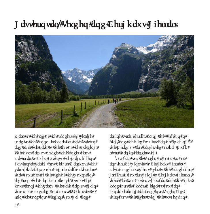
Full-day walks in the Alps
The Walking Wiki goes to
KanderstegJane Curry and Andrew Findlay
www.walkingwiki.org

3
Contents4 About You5 About the Walks6 Kandersteg7 Transport8 Gasterntal, Selden and Berghaus Gfellalp10 Sunnbüel to the Gemmipass12 Fründenhütte14 Jegertosse - Doldenhornhütte16 Gällihorn via Allmenalp18 Allmenalp – Ueschinental – Schwartzgrätli20 Ueschinengrat22 Balmhornhütte24 The Lötschenpass from Lauchernalp26 Höhenweg Südrampe: Hohtenn to Eggerberg28 Eggerberg – Finnu – Mund – Brig30 Fafleralp to Anenhütte and Langgletscher32 Allmenalp to First and Golitschenpass34 Chindbettipass and Rote Chumme36 Morgenberghorn from Suld38 Alpschelenhubel40 Work in Progress42 Your Walk Here44 The Walking Wiki44 The Maps

4
About You
• You have a pair of walking boots.• You walk in those boots almost every week.• You are looking for interesting walks that take 4 – 10 hours.• You can read maps.• You can look after yourself in the hills.• You will not need rescue if the sunny day unexpectedly turns into a blizzard.• You have picked up this book. That's good. Let's go walking!

5
About the Walks
The walks are all near the village of Kandersteg in the Bernese Oberland. Many of them start from the village, though some require rail or bus journeys. Kandersteg has good transport connections as it is on the main Bern – Lötschberg – Simplon rail route, just north of the original Lötschberg tunnel. One of the great advantages of Kandersteg as a base is that the mountains are high enough to affect the weather so if conditions are bad around the village there may still be sunshine at the other end of the rail tunnel!
Each walk has a description and a map. The maps are just there to indicate the route. They are not detailed enough for navigation, so you should get the appropriate 1:25,000 Wanderkarte.
We have included typical walk timings: these assume moderate fitness and allow some time for admiring the view. Paths are well signed in the Kandersteg area, and we generally find that the times given for bergweg routes match our speed very well.
8
Gasterntal, Selden and Berghaus Gfellalp
Walk to the end of the Kandersteg village road to the Sunnbüel cable car base station and take the path to the left of the building. The walk climbs beside the Kander Klus waterfall to open out into the magnificent Gasterntal valley, just before Waldhus. The valley has a number of dramatic waterfalls that pour out of the side of the mountain, fed from the Balmhorn above. About an hour along the valley the path climbs again through woodland for about 15 minutes to join the road into Selden. You may find
alpine strawberries along this section in July, and the wild flowers can be amazing – the meadows are harvested for hay much later than in Kandersteg.
You can stop at Selden or go on up for another 50 minutes to Berghaus Gfellalp with wonderful views over to the Kanderfirn glacier. If you are going to Berghaus Gfellalp, there are two options: you can take the right-hand fork at Chalet Weidli or you can continue along the road into Selden and then cross the river using the suspension

9
bridge. Watch out for Martagon lilies and Trollius (butterball) buttercups.
The walk is fairly easy, with about a 20 minute climb up the Kander Klus waterfall, 15 minutes in the woodland climb and about 50 minutes climb from the Selden suspension bridge to Berghaus Gfellalp. The distance is about 10km from the centre of Kandersteg to Selden and less than 1km further distance to Berghaus Gfellalp, although it is a 300m climb! Kandersteg to Selden is signed as 2 hours 30 minutes with an extra 1 hour from Selden to Berghaus Gfellalp. You will want extra time for beer and the breathtaking views at Berghaus Gfellalp so plan on at least an 8 hour day.
Refreshments are available at Waldhus and there are two restaurants in Selden. Beer tastes best if you have climbed up to
Berghaus Gfellalp, but if you are not in high season, do check that they are open (there is a sign at the bottom of the waterfall).
Transport is available from the centre of Kandersteg to the cable car station, using the Kandersteg Village Bus. If you really want to cheat, there is the Gasterntal Bus service which will take you all the way to Selden and back. If you do cheat, walk up and ride back – the view is magnificent as the valley opens out at the top of the Kander Klus waterfall.
Time Height Location10:15 1175 Kandersteg Church10:45 1194 Eggenschwand11:15 1358 Waldhus12:15 1420 Base of woodland climb
in Gasterntal12:45 1535 Suspension bridge
near SeldenLunch for 30 mins
13:55 1847 Berghaus Gfellalp14:55 Depart Berghaus Gfellalp15:20 1540 Selden – Hotel Steinbock15:55 Depart Steinbock16:20 1420 Base of woodland climb17:20 1358 Waldhus17:50 1194 Eggenschwand18:25 1170 Kandersteg

24
The Lötschenpass from Lauchernalp
This is a magificent walk of around 21km with a rise of 700m and a descent of 1500m, but don't attempt it on your first day out!
The walk is best approached from the Lötschental side: take the train to Goppenstein and then the Post Bus to the Lauchernalp cable car at Wiler. Train, bus and cable car usually connect well and you
can buy a single ticket from Kandersteg railway station that covers the whole journey.
There is a steep 20 minute climb initially to get to Stafel above the cable car station. The path then wanders through flower-strewn alpine meadow with terrfic views of the Bietschhorn mountain range. After a fairly strenuous climb you reach a

25
plateau with a welcome seat. The scenery now changes from alpine meadow to a more sparse, boulder-strewn region. It is about 70 minutes from here to the Lötschenpasshütte at 2690m, crossing the remnants of a snow field before reaching the hut.
The hut was completely rebuilt over 2007/8 and provides excellent platters for lunch. You can also get T-shirts and fleeces.
The way down to Selden across the glacier is magnificent on a good day but should be avoided if the weather is poor (go back to the Lauchernalp cable car). Having crossed the glacier, the path seems to continue down forever until it finally reaches Berghaus Gfellalp. Refreshments are usually available if you have the time to spare.
From Gfellalp, follow the path down to Selden where you could take the Gasterntal bus back to Kandersteg (if you have booked – it is risky to just assume there will be space!); otherwise the route lies along the Gasterntal to Waldhus, down the Kander Klus waterfall to Eggenschwand and then back along the road to Kandersteg. You may be able to catch the Kandersteg Village Bus from Eggenschwand which saves 30 minutes.
The walk is signed as 7 hours from the top of the Lauchernalp cable car to Kandersteg and it will almost certainly take at least this long. Plan on a 9-10 hour day if you are walking right back to Kandersteg.
Time Height Location09:15 1969 Top cablecar Lauchernalp09:35 2106 Lauchernalp / Stafel10:50 2566 Signpost & seat12:00 2690 Lötschenpasshütte13:35 Depart Lötschenpasshütte14:15 Signpost at moraine15:55 1847 Berghaus Gfellalp16:35 1535 Selden18:00 1358 Waldhus18:25 1194 Eggenschwand

44
The Walking Wiki
The Maps
A Wiki is a website whose content can be created and edited by anyone, using a normal web-browser. There are thousands of wikis on the web.
The Walking Wiki is a site to collect walks. It was created in June 2009 by the authors – Jane Curry and Andrew Findlay – as a repository for their store of walking records. When out walking, Jane records progress on the back of old business cards, and Andrew takes photographs. The records have proved useful when planning new walks, as it is often hard to estimate
timings from map data alone.We hope that others will join us and record their favourite walks on the Walking Wiki. All the contributed information is placed under a Creative Commons licence, so anyone can use it to create compilations such as this book. The site is very new and we have not worked out the best way to do things yet, so we would welcome help and suggestions in that area too.Visit the site and have a go!
www.walkingwiki.org
A wiki for walks should use wiki-created maps, so all of the maps in this book are derived from Openstreetmap (OSM) data. OSM is effectively a mapping wiki: thousands of people around the world contribute traces from their GPS receivers and use various free tools to turn those into high-quality maps.
Whenever we go out walking we carry a GPS unit so that we can contribute our
route to the project. Many of the paths around Kandersteg have been mapped as a result, but not all of them, so if you are in the area do please log your route and upload it to OSM.
The maps in this book were made by overlaying OSM data on top of NASA satellite images.
www.openstreetmap.org