the use of aeromagnetic surveys in the framework of ctbto

1
Summary. Aeromagnetic surveys constitute a quick and straightforward method to obtain a geological picture of the area under study, and at the same time it can be applied to identify the possible presence of anthropogenic magnetic signatures. This technique is regularly applied in the minerals and oil and gas exploration industries, geological studies, and detection of unexploded ordnance (UXO), among many other fields. The use of magnetic field mapping is allowed during the continuation period of an on-site inspection (OSI) in the framework of the Comprehensive Nuclear-Test-Ban Treaty (CTBT). When properly applied, it contributes to the search logic of the inspection team by offering a comprehensive coverage of the inspection area in a short period of time, providing basic information about the geology as well as identifying potential targets that can be inspected later from the ground. This paper provides an overview of the aeromagnetic surveys conducted during the Integrated Field Exercise (IFE08), held in September 2008 in the former Soviet nuclear test site at Semipalatinsk, Kazakhstan. Most of the magnetic signatures identified after analysis of the data can be attributed to geological units. However, other magnetic anomalies would require further investigation from the ground in order for their origin to be clarified, demonstrating the utility of this technique in the framework of an OSI. Cesium magnetometer Electronics Towed non-magnetic bird 1 2 3 4 5 6 Airborne GIS 1 - Pilot guidance unit 2 - Planned survey 3 - Real survey conducted 4 - Real-time airplane location 5 - Real-time magnetic field 6 - Real-time coordinates Aerogeophysical Equipment Used During IFE08 Contribution in kind from INGV, Italy Cs2 Cesium Magnetometer Laser Altimeter Global Positioning System Airborne GIS Aeromagnetic Survey Flight Plan Conducted over the eastern part of the inspection area to investigate the possible presence of anthropogenic magnetic signatures over the restricted access site (RAS, square in the top part of the surveyed area) and a scraped zone (lower part). Base station magnetometer installed at the base of operations to monitor daily variations in the Earth’s magnetic field. Aeromagnetic data acquired on 19 September during relative magneticcalm. Survey parameters: 100 metres flight line spacing, constant altitude of 100 metres above ground level, magnetometer towed approximately 30 metres below the helicopter. Length of survey: 5 hours dividedinto two legs. Conclusions. Most of the visible magnetic signatures on the final analytic signal map were attributed to geological and/or topographic units, as could be expected from the survey planning oriented to an initial reconnaissance of the area. However, discrete short wavelength magnetic anomalies were identified, one of them for example in the middle of the RAS, which warranted further investigation from the ground by the inspection team to determine their origin. Therefore, even though the particular aerogeophysical platform and survey were conceived for exploration purposes, aeromagnetism shows its value in the framework of OSI. Further effort shouldbe focused on the developmentand implementation of this technique withinthe search logic of an on-site inspection. Planned survey Real flight path over DEM from GPS altitude collected during survey Total magnetic field: raw data after removing line-crossing and turnovers Total magnetic field: data cleaned with spikes removed Analytic signal (AS) AS over DEM. Main anomalies can be correlated with topographic lineaments Borehole 3001 RAS The Use of Aeromagnetic Surveys in the Framework of CTBTO On-Site Inspections – Experience from IFE08 Luis R. Gaya-Piqué 1 , Ashley Grant 2 , Matthew Purss 3 and George Tuckwell 4 1 On-Site Inspection Division, CTBTO PrepCom, Vienna International Centre, P.O. Box 1200, A-1400, Vienna, Austria, e-mail: [email protected] 2 ARKeX Limited, Newton House, Cambridge Business Park, Cambridge, CB4 0WZ, UK 3 Geoscience Australia, GPO Box 378, Canberra, ACT, 2601, Australia 4 STATS Limited, 18 Frogmore Rd, Hemel Hempstead, HP3 9RT, UK

Upload: others

Post on 21-Jan-2022

2 views

Category:

Documents


0 download

TRANSCRIPT

Summary. Aeromagnetic surveys constitute a quick and straightforward method to obtain a geological picture ofthe area under study, and at the same time it can be applied to identify the possible presence of anthropogenicmagnetic signatures. This technique is regularly applied in the minerals and oil and gas exploration industries,geological studies, and detection of unexploded ordnance (UXO), among many other fields. The use of magneticfield mapping is allowed during the continuation period of an on-site inspection (OSI) in the framework of theComprehensive Nuclear-Test-Ban Treaty (CTBT). When properly applied, it contributes to the search logic ofthe inspection team by offering a comprehensive coverage of the inspection area in a short period of time,providing basic information about the geology as well as identifying potential targets that can be inspected laterfrom the ground. This paper provides an overview of the aeromagnetic surveys conducted during the IntegratedField Exercise (IFE08), held in September 2008 in the former Soviet nuclear test site at Semipalatinsk,Kazakhstan. Most of the magnetic signatures identified after analysis of the data can be attributed to geologicalunits. However, other magnetic anomalies would require further investigation from the ground in order for theirorigin to be clarified, demonstrating the utility of this technique in the framework of an OSI.

Cesium magnetometer Electronics

Towed non-magnetic bird

1

2

34

56

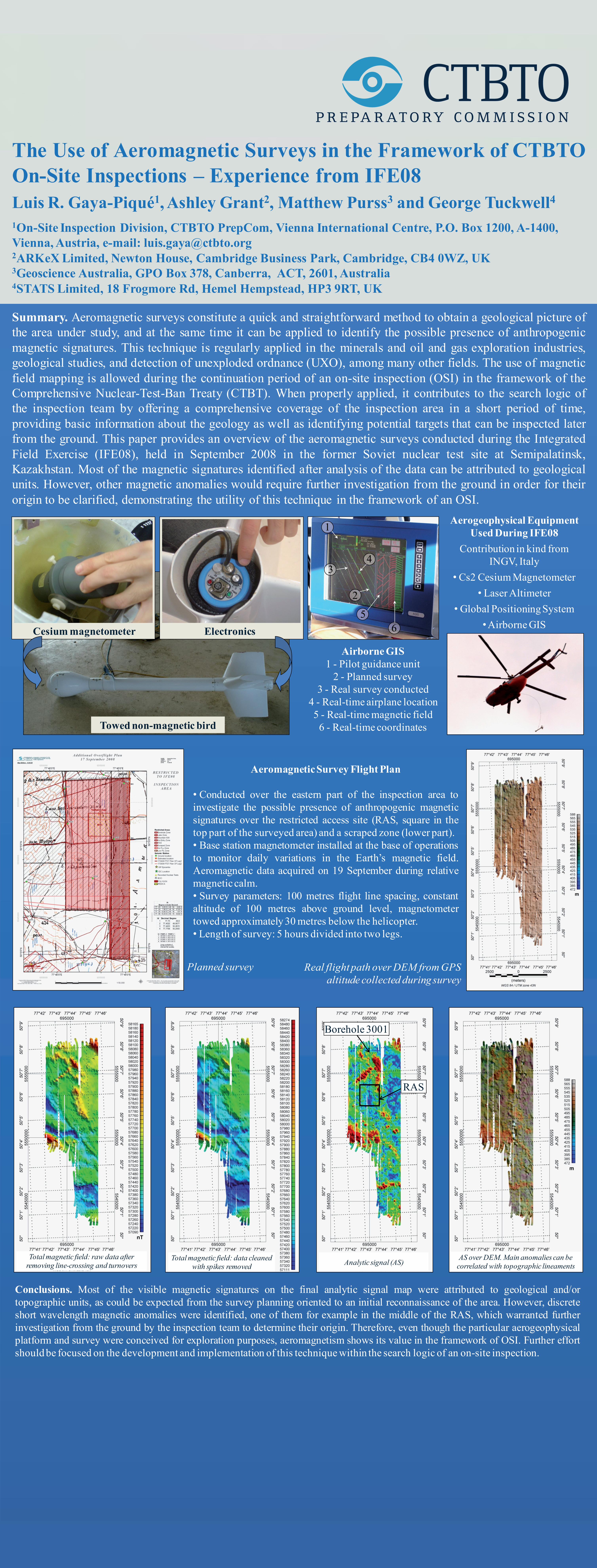
Airborne GIS1 - Pilot guidance unit

2 - Planned survey3 - Real survey conducted

4 - Real-time airplane location5 - Real-time magnetic field

6 - Real-time coordinates

Aerogeophysical Equipment Used During IFE08

Contribution in kind from INGV, Italy

• Cs2 Cesium Magnetometer• Laser Altimeter

•Global Positioning System•Airborne GIS

Aeromagnetic Survey Flight Plan

• Conducted over the eastern part of the inspection area toinvestigate the possible presence of anthropogenic magneticsignatures over the restricted access site (RAS, square in thetop part of the surveyed area) and a scraped zone (lower part).• Base station magnetometer installed at the base of operationsto monitor daily variations in the Earth’s magnetic field.Aeromagnetic data acquired on 19 September during relativemagneticcalm.• Survey parameters: 100 metres flight line spacing, constantaltitude of 100 metres above ground level, magnetometertowed approximately 30 metres below the helicopter.• Length of survey: 5 hours divided into two legs.

Conclusions. Most of the visible magnetic signatures on the final analytic signal map were attributed to geological and/ortopographic units, as could be expected from the survey planning oriented to an initial reconnaissance of the area. However, discreteshort wavelength magnetic anomalies were identified, one of them for example in the middle of the RAS, which warranted furtherinvestigation from the ground by the inspection team to determine their origin. Therefore, even though the particular aerogeophysicalplatform and survey were conceived for exploration purposes, aeromagnetism shows its value in the framework of OSI. Further effortshould be focused on the development and implementation of this technique within the search logic of an on-site inspection.

Planned survey Real flight path over DEM from GPS altitude collected during survey

Total magnetic field: raw data after removing line-crossing and turnovers

Total magnetic field: data cleaned with spikes removed Analytic signal (AS)

AS over DEM. Main anomalies can be correlated with topographic lineaments

Borehole 3001

RAS

The Use of Aeromagnetic Surveys in the Framework of CTBTOOn-Site Inspections – Experience from IFE08Luis R. Gaya-Piqué1, Ashley Grant2, Matthew Purss3 and George Tuckwell4

1On-Site Inspection Division, CTBTO PrepCom, Vienna International Centre, P.O. Box 1200, A-1400, Vienna, Austria, e-mail: [email protected] Limited, Newton House, Cambridge Business Park, Cambridge, CB4 0WZ, UK3Geoscience Australia, GPO Box 378, Canberra, ACT, 2601, Australia4STATS Limited, 18 Frogmore Rd, Hemel Hempstead, HP3 9RT, UK